DSM generation with the Leica/Helava DPW 770 and VirtuoZo digital photogrammetric systems
|
|
|
- Brendan Goodman
- 6 years ago
- Views:
Transcription

1 Research Collection Other Conference Item DSM generation with the Leica/Helava DPW 770 and VirtuoZo digital photogrammetric systems Author(s): Baltsavias, Emmanuel P. Publication Date: 1996 Permanent Link: Rights / License: In Copyright - Non-Commercial Use Permitted This page was generated automatically upon download from the ETH Zurich Research Collection. For more information please consult the Terms of use. ETH Library
2 DSM Generation with the Leica/Helava DPW 770 and VirtuoZo Digital Photogrammetric Systems 1
3 Aims Comparison: Two digital photogrammetric systems DPW770 (Leica/Helava), VirtuoZo (VirtuoZo Systems), especially regarding DSM generation Test: Is automatic DSM generation in mountainous regions with glaciers possible? 2
4 High price Extended functionality Complicated to use Uses epipolar images Image pyramid, 6 levels, set in the strategy file Leica/Helava DPW 770 Matching method: crosscorrelation + object space matching 3 basic strategies and 7 new ones with the IOR matching method Possibility to modify and create new strategy files Regular grid in object space Patch size set in strategy file for each pyramid level, can be changed by user Patch size used in matching 15 x 15 pixels Main System Characteristics Low price Limited functionality VirtuoZo Easy to use, intuitive user interface DSM Generation Uses epipolar images Image pyramid, > 3 levels, automatically determined Matching method: crosscorrelation + global relaxation matching technique 5 strategies (actually not used) No parameters can be set except patch and grid size Regular grid in left image Basic patch size selected by user, changed automatically for higher pyramid levels Patch size used in matching 9 x 9 pixels 3
5 Glacier Data Set 2 aerial images of the Morteratsch glacier, image scale 1:10,000 with overlap 85% scanned on PS1 scanner with pixel size 15µm, reduced to 30µm for DTM generation Reference DTM measured on the analytical plotter AC1 Orientation parameters from bundle adjustment 4


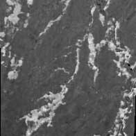
6 Eidgenössische Contrast enhancement with Wallis Filter Original image After Wallis filtering 5

7 Morteratsch glacier with overlayed contours 6
8 Orthoimage 7

9 Unreliable points (determined automatically by DPW 770) 8
10 Statistics of height differences Version Number of points compared Time / Number of match points Maximum absolute (m) Mean (m) RMS (m) DPW 770 (whole image): all points s / 462, DPW 770 (whole image): points with quality code * > , VirtuoZo (whole image) s / 467, DPW 770 (region without big blunders) VirtuoZo (region without big blunders) * Code provided by DPW. Points with code > 32 are considered reliable. 9
11 Percentage of points for various classes of differences Version > 15 DPW 770 (whole image): all points / DPW 770 (whole image): points with code > VirtuoZo (whole image) DPW 770 (region without big blunders) VirtuoZo (region without big blunders)


12 Accuracy analysis in the region without big blunders - 17 m 0 m 10 m 11
13 Yverdon Data Set 2 aerial images of Yverdon, Switzerland, image scale 1:68,000 with overlap 50% scanned with DSW 200, pixel size 12.5µm reduced to 25µm for DTM generation Reference DHM25 from Swiss Federal Office of Topography with RMS of 1.8m Orientation parameters from AC1 12

14 3D parallel view of Yverdon 13

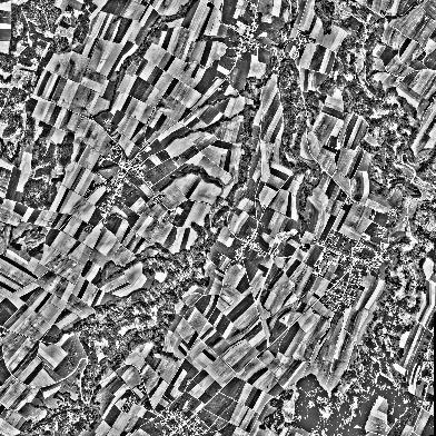
15 Portion of the test region 14

16 DHM25 of Yverdon rolling terrain height differences ca. 430m creeks, forests, urban areas 15

17 Orthoimage of the test region 16
18 Version Statistics of height differences Number of points compared Maximum absolute (m) Mean (m) RMS (m) DPW 770 (nonforested area) 127, DPW 770 (forest area) 42, VirtuoZo (nonforested area) 134, VirtuoZo (forest area) 44, Percentage of points for various classes of differences Version DPW 770 (nonforested area) VirtuoZo (nonforested area)
19 80% m Distribution of the differences 18

20 Differences between VirtuoZo DTM and DHM25 19
21 Difference of DTM Orthoimage 20
22 Strategies for DTM Generation Leica/Helava DPW 770 Strategy files and algorithms behind them generally positive, need improvement User with little knowledge will use the strategies as black box and might run into problems VirtuoZo In reality all strategies delivered completely identical results Strategies are black box. User has no possibility to modify them or create its own Sophisticated user needs more information about parameters, internal computations, etc. Both Systems Matching parameters should be automatically adapted to terrain type, pixel footprint etc. 21
23 DTM Editing Leica/Helava DPW 770 Quality code accessible by user, not reliable enough Editing tools before matching Filtering of spikes, trees, houses possible but needs improvement VirtuoZo Quality is coded with three colors, not accessible by user, not reliable enough Both Systems Provide tools to check errors: contours, color coding of matching points Provide tools to edit data point- or regionwise Need additional quality criteria, e.g. differences of stereo orthoimages 22
24 Advantages (compared to Analytical Plotters) Similar to much lower price Additional functionality (sensor models for satellite imagery, orthoimage, etc.) Advantages of automatic DTM generation: - processing speed (over 100 points per second) - possibility to derive a very dense DTM more accurate terrain representation (implicit measurement of breaklines, etc.) 23
25 Disadvantages The systems are not open and flexible enough Both systems input uncommon image formats which leads to increase of required disk space and processing delays The documentation is poor Many processes appear as a black box to the user 24
26 Conclusions Both systems (DPW 770 and VirtuoZo) are useful for automatic DTM generation and deliver similar accuracy DPW 770 has more functions, but is also more expensive and complicate to use; VirtuoZo offers userfriendliness and low price Efficient, fast and comfortable methods for the automatic detection and exclusion of DTM blunders are still missing in both systems 25
DSM GENERATION FROM EARLY ALOS/PRISM DATA USING SAT-PP
 DSM GENERATION FROM EARLY ALOS/PRISM DATA USING SAT-PP K. Wolff, A. Gruen Institute of Geodesy and Photogrammetry, ETH-Zurich, CH-8093 Zurich, Switzerland @geod.baug.ethz.ch KEY WORDS: PRISM
EVALUATION OF WORLDVIEW-1 STEREO SCENES AND RELATED 3D PRODUCTS
 EVALUATION OF WORLDVIEW-1 STEREO SCENES AND RELATED 3D PRODUCTS Daniela POLI, Kirsten WOLFF, Armin GRUEN Swiss Federal Institute of Technology Institute of Geodesy and Photogrammetry Wolfgang-Pauli-Strasse
SPOT-1 stereo images taken from different orbits with one month difference
 DSM Generation Almost all HR sensors are stereo capable. Some can produce even triplettes within the same strip (facilitating multi-image matching). Mostly SPOT (1-5) used for stereo and Ikonos (in spite
Section 5 Orthoimage generation
 Section 5 Orthoimage generation Emmanuel Baltsavias Orthoimage Generation Older sensor models methods: Kratky s Polynomial Mapping Functions (PMFs) Relief corrected affine transformation - Project GCPs
Tree height measurements and tree growth estimation in a mire environment using digital surface models
 Tree height measurements and tree growth estimation in a mire environment using digital surface models E. Baltsavias 1, A. Gruen 1, M. Küchler 2, P.Thee 2, L.T. Waser 2, L. Zhang 1 1 Institute of Geodesy
AUTOMATIC DSM GENERATION FROM LINEAR ARRAY IMAGERY DATA
 AUTOMATIC DSM GENERATION FROM LINEAR ARRAY IMAGERY DATA Zhang Li, Armin Gruen Institute of Geodesy and Photogrammetry, Swiss Federal Institute of Technology Zurich ETH Hoenggerberg; CH-8093 Zurich, Switzerland
AUTOMATED DTM GENERATION FOR LOW TEXTURED IMAGES USING MULTIPLE PRIMITIVE MULTI-IMAGE MATCHING (MPM)
") AUTOMATED DTM GENERATION FOR LOW TEXTURED IMAGES USING MULTIPLE PRIMITIVE MULTI-IMAGE MATCHING (MPM) M. Sauerbier ETH Zurich, Institute of Geodesy and Photogrammetry, 8093 Zurich, Switzerland martin.sauerbier@geod.baug.ethz.ch
AUTOMATED DTM GENERATION FOR LOW TEXTURED IMAGES USING MULTIPLE PRIMITIVE MULTI-IMAGE MATCHING (MPM) M. Sauerbier ETH Zurich, Institute of Geodesy and Photogrammetry, 8093 Zurich, Switzerland martin.sauerbier@geod.baug.ethz.ch
Mountain mapping and DSM generation using high resolution satellite image data
 Mountain mapping and DSM generation using high resolution satellite image data Mountain Mapping and Visualization Lenk, Switzerland, February 2008 K. Wolff, A. Grün Institut für Geodesie und Photogrammetrie
DIGITAL SURFACE MODELS OF CITY AREAS BY VERY HIGH RESOLUTION SPACE IMAGERY
 DIGITAL SURFACE MODELS OF CITY AREAS BY VERY HIGH RESOLUTION SPACE IMAGERY Jacobsen, K. University of Hannover, Institute of Photogrammetry and Geoinformation, Nienburger Str.1, D30167 Hannover phone +49
UP TO DATE DSM GENERATION USING HIGH RESOLUTION SATELLITE IMAGE DATA
 UP TO DATE DSM GENERATION USING HIGH RESOLUTION SATELLITE IMAGE DATA K. Wolff*, A. Gruen Institute of Geodesy and Photogrammetry, ETH Zurich Wolfgang-Pauli-Str. 15, CH-8093 Zurich, Switzerland (wolff,
GALILEO SISCAM APPROACH TO DIGITAL PHOTOGRAMMETRY. F. Flamigni A. Viti Galileo Siscam S.p.A.
 GALILEO SISCAM APPROACH TO DIGITAL PHOTOGRAMMETRY F. Flamigni A. Viti Galileo Siscam S.p.A. ABSTRACT: The application of the least squares matching procedure to an analytical stereoplotter is described.
3D CITY MODELLING WITH CYBERCITY-MODELER
 1 3D CITY MODELLING WITH CYBERCITY-MODELER Kilian Ulm 1 and Daniela Poli 1 1. CyberCity AG, Zurich, Switzerland, (kilian.ulm, daniela.poli)@cybercity.tv ABSTRACT 3D city models using stereo aerial-/satellite
Files Used in this Tutorial
 Generate Point Clouds and DSM Tutorial This tutorial shows how to generate point clouds and a digital surface model (DSM) from IKONOS satellite stereo imagery. You will view the resulting point clouds
SEMI-AUTOMATIC CITY MODEL EXTRACTION FROM TRI-STEREOSCOPIC VHR SATELLITE IMAGERY
 SEMI-AUTOMATIC CITY MODEL EXTRACTION FROM TRI-STEREOSCOPIC VHR SATELLITE IMAGERY F. Tack a,, R. Goossens a, G. Buyuksalih b a Dept. of Geography, Ghent University, Krijgslaan 281, 9000 Ghent, Belgium (f.tack,
MASI: Modules for Aerial and Satellite Imagery
 MASI: Modules for Aerial and Satellite Imagery Product Descriptions and Typical Applied Cases Dr. Jinghui Yang jhyang@vip.163.com Sept. 18, 2017 File Version: v1.0 VisionOnSky Co., Ltd. Contents 1 Descriptions
GENERATION OF DIGITAL SURFACE MODEL FROM HIGH RESOLUTION SATELLITE IMAGERY
 GENERATION OF DIGITAL SURFACE MODEL FROM HIGH RESOLUTION SATELLITE IMAGERY Chunsun Zhang a, *, Clive Fraser b a Geographic Information Science Center of Excellence (GIScCE), South Dakota State University,
EVALUATION OF WORLDVIEW-1 STEREO SCENES
 EVALUATION OF WORLDVIEW-1 STEREO SCENES Daniela Poli a, Kirsten Wolff b, Armin Gruen b a. European Commission, JRC, via Fermi 2749, Ispra (VA), Italy - daniela.poli@cec.europa.eu b. Swiss Federal Institute
IMPROVING CARTOGRAPHIC ROAD DATABASES BY IMAGE ANALYSIS
 IMPROVING CARTOGRAPHIC ROAD DATABASES BY IMAGE ANALYSIS Chunsun Zhang, Emmanuel Baltsavias Institute of Geodesy and Photogrammetry, Swiss Federal Institute of Technology Zurich, ETH Hoenggerberg, CH-8093
Integration of raster and vector data for 3D city modelling URMO3D Orfeo Project OR/02/02 Dennis Devriendt Prof. Rudi Goossens
 Integration of raster and vector data for 3D city modelling URMO3D Orfeo Project OR/02/02 Dennis Devriendt Prof. Rudi Goossens 1 Presentation overview URMO3D In one sentence Objectives Study areas Methodology
Digital Elevation Models (DEMs)
") Digital Elevation Models (DEM) - Terrain Models (DTM) How has relief depiction on maps and online changed with digital mapping/ GIS?.. Perhaps more than the other map elements / layers Digital Elevation
Digital Elevation Models (DEM) - Terrain Models (DTM) How has relief depiction on maps and online changed with digital mapping/ GIS?.. Perhaps more than the other map elements / layers Digital Elevation
Automated Orientation of Aerial Images
 Automated Orientation of Aerial Images Joachim Höhle Aalborg University Denmark jh@i4.auc.dk Abstract Methods for automated orientation of aerial images are presented. They are based on the use of templates,
OPTIMISING THE WORKFLOW IN A HYBRID PRODUCTION SYSTEM OF ANALYTICAL AND DIGITAL PRODUCTION OF GEODATA USING AERIAL PHOTOGRAPHS
 OPTIMISING THE WORKFLOW IN A HYBRID PRODUCTION SYSTEM OF ANALYTICAL AND DIGITAL PRODUCTION OF GEODATA USING AERIAL PHOTOGRAPHS H. O. Kena a, *, T. Wemegah a a Rudan Engineering Limited, Mapping Unit, P.O.
GENERATION OF DIGITAL SURFACE MODEL FROM HIGH RESOLUTION SATELLITE IMAGERY INTRODUCTION
 GENERATION OF DIGITAL SURFACE MODEL FROM HIGH RESOLUTION SATELLITE IMAGERY Chunsun Zhang, Associate Professor Geographic Information Science Center of Excellence (GIScCE) South Dakota State University
TrueOrtho with 3D Feature Extraction
 TrueOrtho with 3D Feature Extraction PCI Geomatics has entered into a partnership with IAVO to distribute its 3D Feature Extraction (3DFE) software. This software package compliments the TrueOrtho workflow
Digital Aerial Triangulation with the Helava Automated Triangulation System
 Digital Aerial Triangulation with the Helava Automated Triangulation System Thomas Kersten, Willie O Sullivan swissair Photo+Surveys Ltd. Dorfstr. 53, CH - 8105 Regensdorf-Watt, Switzerland Phone +41 1
Geometric Accuracy Evaluation, DEM Generation and Validation for SPOT-5 Level 1B Stereo Scene
 Geometric Accuracy Evaluation, DEM Generation and Validation for SPOT-5 Level 1B Stereo Scene Buyuksalih, G.*, Oruc, M.*, Topan, H.*,.*, Jacobsen, K.** * Karaelmas University Zonguldak, Turkey **University
Improving wide-area DEMs through data fusion - chances and limits
 Improving wide-area DEMs through data fusion - chances and limits Konrad Schindler Photogrammetry and Remote Sensing, ETH Zürich How to get a DEM for your job? for small projects (or rich people) contract
Investigations on Two Methods of DEM Extraction
 Santhakumar: Investigations on Two Methods of DEM Extraction Investigations on Two Methods of DEM Extraction Rasheed Saleem Abed Lecturer, Remote Sensing Centre University of Mosul Iraq mosul_5@yahoo.com
DENSE 3D POINT CLOUD GENERATION FROM UAV IMAGES FROM IMAGE MATCHING AND GLOBAL OPTIMAZATION
 DENSE 3D POINT CLOUD GENERATION FROM UAV IMAGES FROM IMAGE MATCHING AND GLOBAL OPTIMAZATION S. Rhee a, T. Kim b * a 3DLabs Co. Ltd., 100 Inharo, Namgu, Incheon, Korea ahmkun@3dlabs.co.kr b Dept. of Geoinformatic
POSITIONING A PIXEL IN A COORDINATE SYSTEM
 GEOREFERENCING AND GEOCODING EARTH OBSERVATION IMAGES GABRIEL PARODI STUDY MATERIAL: PRINCIPLES OF REMOTE SENSING AN INTRODUCTORY TEXTBOOK CHAPTER 6 POSITIONING A PIXEL IN A COORDINATE SYSTEM The essential
A NEW STRATEGY FOR DSM GENERATION FROM HIGH RESOLUTION STEREO SATELLITE IMAGES BASED ON CONTROL NETWORK INTEREST POINT MATCHING
 A NEW STRATEGY FOR DSM GENERATION FROM HIGH RESOLUTION STEREO SATELLITE IMAGES BASED ON CONTROL NETWORK INTEREST POINT MATCHING Z. Xiong a, Y. Zhang a a Department of Geodesy & Geomatics Engineering, University
EPIPOLAR IMAGES FOR CLOSE RANGE APPLICATIONS
 EPIPOLAR IMAGES FOR CLOSE RANGE APPLICATIONS Vassilios TSIOUKAS, Efstratios STYLIANIDIS, Petros PATIAS The Aristotle University of Thessaloniki, Department of Cadastre Photogrammetry and Cartography Univ.
COMPARATIVE CHARACTERISTICS OF DEM OBTAINED FROM SATELLITE IMAGES SPOT-5 AND TK-350
 COMPARATIVE CHARACTERISTICS OF DEM OBTAINED FROM SATELLITE IMAGES SPOT-5 AND TK-350 Dr. V. F. Chekalin a*, M. M. Fomtchenko a* a Sovinformsputnik, 47, Leningradsky Pr., 125167 Moscow, Russia common@sovinformsputnik.com
A SYSTEM OF THE SHADOW DETECTION AND SHADOW REMOVAL FOR HIGH RESOLUTION CITY AERIAL PHOTO
 A SYSTEM OF THE SHADOW DETECTION AND SHADOW REMOVAL FOR HIGH RESOLUTION CITY AERIAL PHOTO Yan Li a, Tadashi Sasagawa b, Peng Gong a,c a International Institute for Earth System Science, Nanjing University,
ATOMI Automatic road centreline extraction
 ATOMI input and output data Ortho images DTM/DSM 2D inaccurate structured road vector data ATOMI Automatic road centreline extraction 3D accurate structured road vector data Classification of roads according
Image matching, point transfer, DSM generation
 Image matching, point transfer, DSM generation Dr. Maria Pateraki Department of Rural and Surveying Engineering Aristotle University of Thessaloniki tel:30 2310 996407, email: mariapat@topo.auth.gr, URL:
THE EUROSDR PROJECT AUTOMATED CHECKING AND IMPROVING OF DIGITAL TERRAIN MODELS
 THE EUROSDR PROJECT AUTOMATED CHECKING AND IMPROVING OF DIGITAL TERRAIN MODELS Dr. Joachim Höhle Aalborg University 9220 Aalborg, Denmark jh@land.aau.dk ABSTRACT The results of the research project Checking
A COMPARISON OF LIDAR TERRAIN DATA WITH AUTOCORRELATED DSM EXTRACTED FROM DIGITALLY ACQUIRED HIGH OVERLAP PHOTOGRAPHY BACKGROUND
 A COMPARISON OF LIDAR TERRAIN DATA WITH AUTOCORRELATED DSM EXTRACTED FROM DIGITALLY ACQUIRED HIGH OVERLAP PHOTOGRAPHY Devin Kelley, Project Manager, Certified Photogrammetrist (ASPRS) Thomas Loecherbach,
Research Collection. Metric information extraction from spot images and the role of polynomial mapping functions. Conference Paper.
 Research Collection Conference Paper Metric information extraction from spot images and the role of polynomial mapping functions Author(s): Baltsavias, Emmanuel P.; Stallmann, Dirk Publication Date: 1992
PHOTOGRAMMETRIC PROCESSING OF LOW ALTITUDE IMAGE SEQUENCES BY UNMANNED AIRSHIP
 PHOTOGRAMMETRIC PROCESSING OF LOW ALTITUDE IMAGE SEQUENCES BY UNMANNED AIRSHIP Yongjun Zhang School of Remote Sensing and Information Engineering, Wuhan University, Wuhan, Hubei, 430079, P.R. China - zhangyj@whu.edu.cn
AUTOMATIC EXTRACTION OF 3D MODEL COORDINATES USING DIGITAL STEREO IMAGES
 AUTOMATIC EXTRACTION OF 3D MODEL COORDINATES USING DIGITAL STEREO IMAGES Evangelos G Papapanagiotu, Ph.D. Candidate (1) Prof. Dr. John N Hatzopoulos, Director (2) Remote Sensing Laboratory, Department
ABSTRACT 1. INTRODUCTION
 Published in SPIE Proceedings, Vol.3084, 1997, p 336-343 Computer 3-d site model generation based on aerial images Sergei Y. Zheltov, Yuri B. Blokhinov, Alexander A. Stepanov, Sergei V. Skryabin, Alexander
Photogrammetric Performance of an Ultra Light Weight Swinglet UAV
 Photogrammetric Performance of an Ultra Light Weight Swinglet UAV J. Vallet, F. Panissod, C. Strecha, M. Tracol UAV-g 2011 - Unmanned Aerial Vehicle in Geomatics September 14-16, 2011ETH Zurich Summary
Thomas Labe. University ofbonn. A program for the automatic exterior orientation called AMOR was developed by Wolfgang
 Contributions to the OEEPE-Test on Automatic Orientation of Aerial Images, Task A - Experiences with AMOR Thomas Labe Institute of Photogrammetry University ofbonn laebe@ipb.uni-bonn.de (in: OEEPE Publication
A NEW APPROACH FOR GENERATING A MEASURABLE SEAMLESS STEREO MODEL BASED ON MOSAIC ORTHOIMAGE AND STEREOMATE
 A NEW APPROACH FOR GENERATING A MEASURABLE SEAMLESS STEREO MODEL BASED ON MOSAIC ORTHOIMAGE AND STEREOMATE Mi Wang State Key Laboratory of Information Engineering in Surveying Mapping and Remote Sensing
3-D Building Reconstruction with ARUBA: A Qualitative and Quantitative Evaluation
 AutomaticExtraction of Man-Made Objects from Aerial and Space Images (II) Monte Veritl, @ 1997 Birkhiiuser Verlag Basel 65 3-D Building Reconstruction with ARUBA: A Qualitative and Quantitative Evaluation
New Requirements for the Relief in the Topographic Databases of the Institut Cartogràfic de Catalunya
 New Requirements for the Relief in the Topographic Databases of the Institut Cartogràfic de Catalunya Blanca Baella, Maria Pla Institut Cartogràfic de Catalunya, Barcelona, Spain Abstract Since 1983 the
Lecture 4: Digital Elevation Models
 Lecture 4: Digital Elevation Models GEOG413/613 Dr. Anthony Jjumba 1 Digital Terrain Modeling Terms: DEM, DTM, DTEM, DSM, DHM not synonyms. The concepts they illustrate are different Digital Terrain Modeling
High-Accuracy Satellite Image Analysis and Rapid DSM Extraction for Urban Environment Evaluations (Tripoli-Libya)
") High-Accuracy Satellite Image Analysis and Rapid DSM Extraction for Urban Environment Evaluations (Tripoli-Libya) Abdunaser Abduelmula, Maria Luisa M. Bastos, José A. Gonçalves International Science Index,
High-Accuracy Satellite Image Analysis and Rapid DSM Extraction for Urban Environment Evaluations (Tripoli-Libya) Abdunaser Abduelmula, Maria Luisa M. Bastos, José A. Gonçalves International Science Index,
Precise laser-based optical 3D measurement of welding seams under water
 Precise laser-based optical 3D measurement of welding seams under water ISPRS/CIPA Workshop Underwater 3D Recording & Modeling" Piano di Sorrento (Napoli), Italy 16. 17. April 2015 Tanja Ekkel (M.Sc.)
Trimble Geospatial Division Integrated Solutions for Geomatics professions. Volker Zirn Regional Sales Representative
 Trimble Geospatial Division Integrated Solutions for Geomatics professions Volker Zirn Regional Sales Representative 1 Agenda Trimble GeoSpatial Division Airborne System Solutions Trimble Inpho Software
Digital photogrammetry project with very high-resolution stereo pairs acquired by DigitalGlobe, Inc. satellite Worldview-2
 White PAPER Greater area of the City of La Paz, Bolivia Digital photogrammetry project with very high-resolution stereo pairs acquired by DigitalGlobe, Inc. satellite Worldview-2 By: Engineers Nelson Mattie,
Automatic DEM Extraction
 Technical Specifications Automatic DEM Extraction The Automatic DEM Extraction module allows you to create Digital Elevation Models (DEMs) from stereo airphotos, stereo images and RADAR data. Image correlation
Creating, balancing and mosaicing Orthophotos
 Creating, balancing and mosaicing Orthophotos Wizards Map production 3D presentations Annotation Orthophoto Surface gridding Contouring Image mosaicing Data compression Geocoding Spatial analysis Raster
TRIMBLE BUSINESS CENTER PHOTOGRAMMETRY MODULE
 TRIMBLE BUSINESS CENTER PHOTOGRAMMETRY MODULE WHITE PAPER TRIMBLE GEOSPATIAL DIVISION WESTMINSTER, COLORADO, USA July 2013 ABSTRACT The newly released Trimble Business Center Photogrammetry Module is compatible
Snake-based approach for building extraction from high-resolution satellite images and height data in urban areas
 Snake-based approach for building extraction from high-resolution satellite images and height data in urban areas Tao Guo* Yoshifumi Yasuoka** *Institute of Industrial Science, University of Tokyo Ce-509,
Accuracy Characteristics of ALOS World 3D 30m DSM
 Accuracy Characteristics of ALOS World 3D 30m DSM Karsten Jacobsen Leibniz University Hannover, Germany Institute of Photogrammetry and Geoinformation jacobsen@ipi.uni-hannover.de 1 Introduction Japanese
Improvement of the Edge-based Morphological (EM) method for lidar data filtering
 method for lidar data filtering") International Journal of Remote Sensing Vol. 30, No. 4, 20 February 2009, 1069 1074 Letter Improvement of the Edge-based Morphological (EM) method for lidar data filtering QI CHEN* Department of Geography,
International Journal of Remote Sensing Vol. 30, No. 4, 20 February 2009, 1069 1074 Letter Improvement of the Edge-based Morphological (EM) method for lidar data filtering QI CHEN* Department of Geography,
Light Detection and Ranging (LiDAR)
") Light Detection and Ranging (LiDAR) http://code.google.com/creative/radiohead/ Types of aerial sensors passive active 1 Active sensors for mapping terrain Radar transmits microwaves in pulses determines
Light Detection and Ranging (LiDAR) http://code.google.com/creative/radiohead/ Types of aerial sensors passive active 1 Active sensors for mapping terrain Radar transmits microwaves in pulses determines
Merging LiDAR Data with Softcopy Photogrammetry Data
 Merging LiDAR Data with Softcopy Photogrammetry Data Cindy McCallum WisDOT\Bureau of Technical Services Surveying & Mapping Section Photogrammetry Unit Overview Terms and processes Why use data from LiDAR
[Youn *, 5(11): November 2018] ISSN DOI /zenodo Impact Factor
![[Youn *, 5(11): November 2018] ISSN DOI /zenodo Impact Factor](/thumbs/91/105079225.jpg "[Youn *, 5(11): November 2018] ISSN DOI /zenodo Impact Factor") GLOBAL JOURNAL OF ENGINEERING SCIENCE AND RESEARCHES AUTOMATIC EXTRACTING DEM FROM DSM WITH CONSECUTIVE MORPHOLOGICAL FILTERING Junhee Youn *1 & Tae-Hoon Kim 2 *1,2 Korea Institute of Civil Engineering
GLOBAL JOURNAL OF ENGINEERING SCIENCE AND RESEARCHES AUTOMATIC EXTRACTING DEM FROM DSM WITH CONSECUTIVE MORPHOLOGICAL FILTERING Junhee Youn *1 & Tae-Hoon Kim 2 *1,2 Korea Institute of Civil Engineering
AUTOMATIC TERRAIN EXTRACTION USING MULTIPLE IMAGE PAIR AND BACK MATCHING INTRODUCTION
 AUTOMATIC TERRAIN EXTRACTION USING MULTIPLE IMAGE PAIR AND BACK MATCHING Bingcai Zhang, Chief Photogrammetrist Scott Miller, Chief Engineer Kurt DeVenecia, Product Manager Stewart Walker, Director of Marketing
Extracting Elevation from Air Photos
 Extracting Elevation from Air Photos TUTORIAL A digital elevation model (DEM) is a digital raster surface representing the elevations of a terrain for all spatial ground positions in the image. Traditionally
ACCURACY ANALYSIS AND SURFACE MAPPING USING SPOT 5 STEREO DATA
 ACCURACY ANALYSIS AND SURFACE MAPPING USING SPOT 5 STEREO DATA Hannes Raggam Joanneum Research, Institute of Digital Image Processing Wastiangasse 6, A-8010 Graz, Austria hannes.raggam@joanneum.at Commission
AUTOMATIC IMAGE ORIENTATION BY USING GIS DATA
 AUTOMATIC IMAGE ORIENTATION BY USING GIS DATA Jeffrey J. SHAN Geomatics Engineering, School of Civil Engineering Purdue University IN 47907-1284, West Lafayette, U.S.A. jshan@ecn.purdue.edu Working Group
IMAGE MATCHING TOWARDS MATURITY
 IMAGE MATCHING TOWARDS MATURITY Dimitris P. SKARLATOS Department of Surveying, National Technical University, GR-1578 Athens, Greece dskarlat@survey.ntua.gr Working Group III/2 KEY WORDS: Image Matching,
PRACTICAL METHODS FOR THE VERIFICATION OF COUNTRYWIDE TERRAIN AND SURFACE MODELS
 PRACTICAL METHODS FOR THE VERIFICATION OF COUNTRYWIDE TERRAIN AND SURFACE MODELS Roberto Artuso, Stéphane Bovet, André Streilein roberto.artuso@swisstopo.ch Swiss Federal Office of Topographie, CH-3084
BUILDING DETECTION AND STRUCTURE LINE EXTRACTION FROM AIRBORNE LIDAR DATA
 BUILDING DETECTION AND STRUCTURE LINE EXTRACTION FROM AIRBORNE LIDAR DATA C. K. Wang a,, P.H. Hsu a, * a Dept. of Geomatics, National Cheng Kung University, No.1, University Road, Tainan 701, Taiwan. China-
DEVELOPMENT OF ORIENTATION AND DEM/ORTHOIMAGE GENERATION PROGRAM FOR ALOS PRISM
 DEVELOPMENT OF ORIENTATION AND DEM/ORTHOIMAGE GENERATION PROGRAM FOR ALOS PRISM Izumi KAMIYA Geographical Survey Institute 1, Kitasato, Tsukuba 305-0811 Japan Tel: (81)-29-864-5944 Fax: (81)-29-864-2655
Presented at the FIG Congress 2018, May 6-11, 2018 in Istanbul, Turkey
 Presented at the FIG Congress 2018, May 6-11, 2018 in Istanbul, Turkey Evangelos MALTEZOS, Charalabos IOANNIDIS, Anastasios DOULAMIS and Nikolaos DOULAMIS Laboratory of Photogrammetry, School of Rural
Airborne Laser Survey Systems: Technology and Applications
 Abstract Airborne Laser Survey Systems: Technology and Applications Guangping HE Lambda Tech International, Inc. 2323B Blue Mound RD., Waukesha, WI-53186, USA Email: he@lambdatech.com As mapping products
MODELING OF THE PLAN DA MATTUN ARCHAEOLOGICAL SITE USING A COMBINATION OF DIFFERENT SENSORS
 MODELING OF THE PLAN DA MATTUN ARCHAEOLOGICAL SITE USING A COMBINATION OF DIFFERENT SENSORS D. Novák, P. Tokarczyk*, P.W. Theiler Institute of Geodesy and Photogrammetry, ETH Zürich, 8093 Zürich, Switzerland
Literature review for 3D Design Terrain Models for Construction Plans and GPS Control of Highway Construction Equipment
 Literature review for 3D Design Terrain Models for Construction Plans and GPS Control of Highway Construction Equipment Cassie Hintz Construction and Materials Support Center Department of Civil and Environmental
Stereo Analyst User s Guide
 User s Guide Copyright 2006 Leica Geosystems Geospatial Imaging, LLC All rights reserved. Printed in the United States of America. The information contained in this document is the exclusive property of
Iowa Department of Transportation Office of Design. Photogrammetric Mapping Specifications
 Iowa Department of Transportation Office of Design Photogrammetric Mapping Specifications March 2015 1 Purpose of Manual These Specifications for Photogrammetric Mapping define the standards and general
A BIRD S EYE VIEW ON SWITZERLAND IN THE 18 TH CENTURY: 3D RECORDING AND ANALYSIS OF A HISTORICAL RELIEF MODEL
 A BIRD S EYE VIEW ON SWITZERLAND IN THE 18 TH CENTURY: 3D RECORDING AND ANALYSIS OF A HISTORICAL RELIEF MODEL Jana Niederoest Institute of Geodesy and Photogrammetry, Swiss Federal Institute of Technology
EVALUATION OF ZY-3 FOR DSM AND ORTHO IMAGE GENERATION
 EVALUATION OF FOR DSM AND ORTHO IMAGE GENERATION Pablo d Angelo German Aerospace Center (DLR), Remote Sensing Technology Institute D-82234 Wessling, Germany email: Pablo.Angelo@dlr.de KEY WORDS:, Satellite,
DEVELOPMENT AND STATUS OF IMAGE MATCHING IN PHOTOGRAMMETRY
 The Photogrammetric Record 27(137): 36 57 (March 2012) DOI: 10.1111/j.1477-9730.2011.00671.x DEVELOPMENT AND STATUS OF IMAGE MATCHING IN PHOTOGRAMMETRY Armin Gruen (armin.gruen@geod.baug.ethz.ch) Institute
DTM EXTRACTION FROM MIDDLE-RESOLUTION SATELLITE IMAGERY FOR LANDSCAPE MODELING AND GIS APPLICATIONS
 DTM EXTRACTION FROM MIDDLE-RESOLUTION SATELLITE IMAGERY FOR LANDSCAPE MODELING AND GIS APPLICATIONS D. Poli, C. Dolci, F. Remondino ETH Zurich, Institute of Geodesy and Photogrammetry 8093 Zurich, Switzerland
DIGITAL SURFACE MODELS IN BUILD UP AREAS BASED ON VERY HIGH RESOLUTION SPACE IMAGES
 DIGITAL SURFACE MODELS IN BUILD UP AREAS BASED ON VERY HIGH RESOLUTION SPACE IMAGES Gurcan Buyuksalih*, Karsten Jacobsen** *BIMTAS, Tophanelioglu Cad. ISKI Hizmet Binasi No:62 K.3-4 34460 Altunizade-Istanbul,
Aalborg Universitet. Published in: Accuracy Publication date: Document Version Early version, also known as pre-print
 Aalborg Universitet A method for checking the planimetric accuracy of Digital Elevation Models derived by Airborne Laser Scanning Høhle, Joachim; Øster Pedersen, Christian Published in: Accuracy 2010 Publication
DIGITAL TERRAIN MODELS
 DIGITAL TERRAIN MODELS 1 Digital Terrain Models Dr. Mohsen Mostafa Hassan Badawy Remote Sensing Center GENERAL: A Digital Terrain Models (DTM) is defined as the digital representation of the spatial distribution
Experience in Applying Matching Techniques Using Images from Digital Cameras
 'Photogrammetric Week 05' Dieter Fritsch, Ed. Wichmann Verlag, Heidelberg 2005. Heuchel 181 Experience in Applying Matching Techniques Using Images from Digital Cameras TOBIAS HEUCHEL, Stuttgart ABSTRACT
AN INTEGRATED SENSOR ORIENTATION SYSTEM FOR AIRBORNE PHOTOGRAMMETRIC APPLICATIONS
 AN INTEGRATED SENSOR ORIENTATION SYSTEM FOR AIRBORNE PHOTOGRAMMETRIC APPLICATIONS M. J. Smith a, *, N. Kokkas a, D.W.G. Park b a Faculty of Engineering, The University of Nottingham, Innovation Park, Triumph
Surpac Google Earth Tools
 Surpac Google Earth Tools Google Earth is a free software program that lets you fly anywhere on Earth to view satellite imagery, maps, terrain and 3D buildings. When used in conjunction with SURPAC, it
SimActive and PhaseOne Workflow case study. By François Riendeau and Dr. Yuri Raizman Revision 1.0
 SimActive and PhaseOne Workflow case study By François Riendeau and Dr. Yuri Raizman Revision 1.0 Contents 1. Introduction... 2 1.1. Simactive... 2 1.2. PhaseOne Industrial... 2 2. Testing Procedure...
THE RESULTS OF THRESHOLD SETTINGS ON MODELBASED RECOGNITION AND PARAMETER ESTIMATION OF BUILDINGS FROM MULTI-VIEW AERIAL IMAGERY
 THE RESULTS OF THRESHOLD SETTINGS ON MODELBASED RECOGNITION AND PARAMETER ESTIMATION OF BUILDINGS FROM MULTI-VIEW AERIAL IMAGERY Luuk Spreeuwers, Klamer Schutte and Zweitze Houkes Laboratory for Measurement
National Science Foundation Engineering Research Center. Bingcai Zhang BAE Systems San Diego, CA
 Bingcai Zhang BAE Systems San Diego, CA 92127 Bingcai.zhang@BAESystems.com Introduction It is a trivial task for a five-year-old child to recognize and name an object such as a car, house or building.
GIS Data Collection. This chapter reviews the main methods of GIS data capture and transfer and introduces key practical management issues.
 9 GIS Data Collection OVERVIEW This chapter reviews the main methods of GIS data capture and transfer and introduces key practical management issues. It distinguishes between primary (direct measurement)
MASI: Modules for Aerial and Satellite Imagery. Version 3.0 Aerial Modules. Tutorial
 MASI: Modules for Aerial and Satellite Imagery Version 3.0 Aerial Modules Tutorial VisionOnSky Co., Ltd. www.visiononsky.com File Version: v1.0 Sept. 12, 2018 Special Notes: (1) Before starting the tour
LIDAR MAPPING FACT SHEET
 1. LIDAR THEORY What is lidar? Lidar is an acronym for light detection and ranging. In the mapping industry, this term is used to describe an airborne laser profiling system that produces location and
MASI: Modules for Aerial and Satellite Imagery. Version 3.0 Satellite Modules. Tutorial
 MASI: Modules for Aerial and Satellite Imagery Version 3.0 Satellite Modules Tutorial VisionOnSky Co., Ltd. www.visiononsky.com File Version: v1.0 Sept. 14, 2018 Special Notes: (1) Before starting the
QGIS plugin or web app? Lessons learned from the development of a 3D georeferencer.
 QGIS plugin or web app? Lessons learned from the development of a 3D georeferencer. Produit Timothée 1, Jens Ingensand 2, and Gillian Milani 3 1-2 University of Applied Sciences Western Switzerland, G2C
A Rule-Based System for House Reconstruction from Aerial Images
 A Rule-Based System for House Reconstruction from Aerial Images Wolfram Willuhn and Frank Ade Communication Technology Lab, Swiss Federal Institute of Technology Zürich CH-8092 Zürich, Switzerland E-mail:
Leica Photogrammetry Suite Automatic Terrain Extraction
 Leica Photogrammetry Suite Automatic Terrain Extraction Copyright 2006 Leica Geosystems Geospatial Imaging, LLC All rights reserved. Printed in the United States of America. The information contained in
THE PHOTOGRAMMETRIC DERIVATION OF DIGITAL TERRAIN MODELS IN BUILT-UP AREAS. Geoinformatics and Cartography, Czech Republic
 The Photogrammetric Journal of Finland, Vol. 22, No. 1, 2010 Received 18.9.2009, Accepted 21.05.2010 THE PHOTOGRAMMETRIC DERIVATION OF DIGITAL TERRAIN MODELS IN BUILT-UP AREAS Joachim Höhle 1, Christian
Digital Photogrammetric System. Version 6.3 USER MANUAL. DTM Generation
 Digital Photogrammetric System Version 6.3 USER MANUAL Table of Contents 1. Purpose of the document... 5 2.... 5 3. Regular grid of nodes... 5 3.1. Grid creation... 5 3.2. Grid parameters... 7 4. Points...
INVESTIGATION OF 1:1,000 SCALE MAP GENERATION BY STEREO PLOTTING USING UAV IMAGES
 INVESTIGATION OF 1:1,000 SCALE MAP GENERATION BY STEREO PLOTTING USING UAV IMAGES S. Rhee a, T. Kim b * a 3DLabs Co. Ltd., 100 Inharo, Namgu, Incheon, Korea ahmkun@3dlabs.co.kr b Dept. of Geoinformatic
Surface Contents Author Index
 Surface Contents Author Index Younian WANG, Xinghe YANG, Mladen Stojic & Brad Skelton A NEW DIGITAL PHOTOGRAMMETRIC SYSTEM FOR GIS PROFESSIONALS Younian WANG, Xinghe YANG, Mladen Stojic, Brad Skelton Leica
CO-REGISTERING AND NORMALIZING STEREO-BASED ELEVATION DATA TO SUPPORT BUILDING DETECTION IN VHR IMAGES
 CO-REGISTERING AND NORMALIZING STEREO-BASED ELEVATION DATA TO SUPPORT BUILDING DETECTION IN VHR IMAGES Alaeldin Suliman, Yun Zhang, Raid Al-Tahir Department of Geodesy and Geomatics Engineering, University