ATOMI Automatic road centreline extraction
|
|
|
- Winfred Roberts
- 5 years ago
- Views:
Transcription

1 ATOMI input and output data Ortho images DTM/DSM 2D inaccurate structured road vector data ATOMI Automatic road centreline extraction 3D accurate structured road vector data Classification of roads according to landcover forest urban rural area 1


2 General Strategy Use of existing knowledge, rules and models Use and fusion of multiple cues about road existence Creation of redundancy through multiple cues to account for errors Early transition to object space, use of 2D and 3D interactions to bridge gaps and missing road parts Object-oriented approach in multiple objects (e.g. road classes) + Features, Cues and Algorithms Input Stereo color aerial images / orthos Processing Feature Extraction Features, cues zebra crossings 2-D straight edges 2-D road marks Image Matching 3-D straight edges 3-D road marks DSM Image Classification ndsm Generation road regions shadows vegetation buildings above-ground and ground objects Geodatabase Information Derivation road geometry road attributes road topology landcover


3 How ATOMI road extraction works a. Straight edge extraction b. Removal of irrelevant edges c. Detection of Parallel Road Sides d. Evaluation of Missing Road Sides e. Bridging Gaps f. Linking Road Sides to Extract Roads 3

")
 Quickbird")


4 Test site in Switzerland Geneva 7km² Aerial Film 50cm (summer 98) IKONOS PSM 100cm (May 01) Quickbird PSM 70cm (July 03) Manually measured reference data from 50cm orthophotos Results from Geneva (yellow VECTOR25, black result) 50cm Aerial Film 100cm IKONOS 70cm QUICKBIRD 4


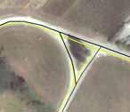

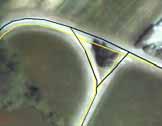
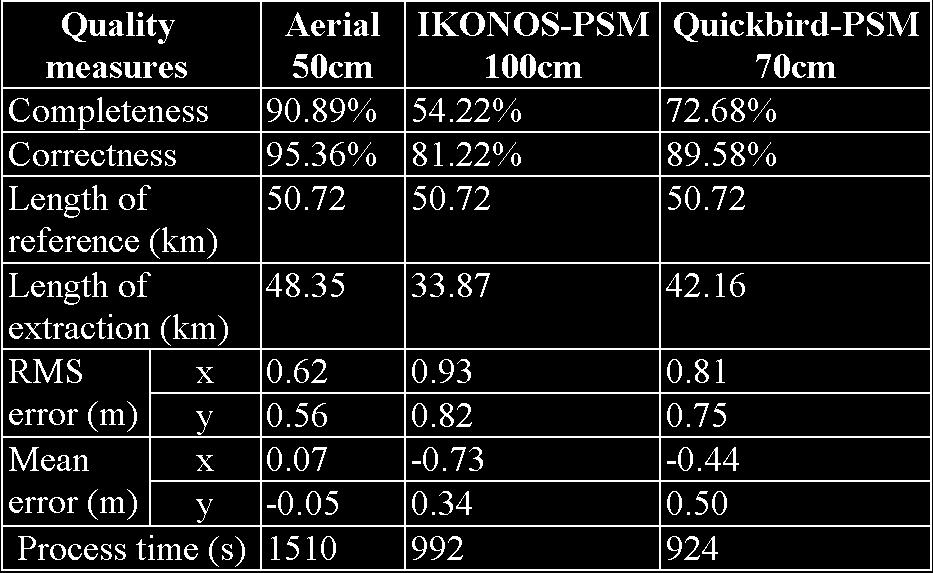
5 50cm Film 100cm IKON 70cm QBIRD 50cm Film 100cm IKON 70cm QBIRD Quality evaluation of the results of Geneva 5
 of the satellite data was inferior to aerial imagery, especially the 1m IKONOS imagery In the satellite data, higher class (wider) roads were usually")
6 Results from Geneva The system achieved good results with the 50cm aerial film imagery with 90% of rural roads extracted. The performance (mainly the completeness) of the satellite data was inferior to aerial imagery, especially the 1m IKONOS imagery In the satellite data, higher class (wider) roads were usually extracted, while most lower class (narrower) roads were not. This is because of ATOMI s algorithm requirement of min. 3 pixels road widths was not fulfilled. The smaller GSD of Quickbird made more roads visible and the road surface and road edges were clearer. But compared to aerial film the completeness was lower. With smaller GSD, correctness and accuracy do not deteriorate much, but completeness yes. Building Extraction, Ikonos, Melbourne Roof corners 19 roof corners measured by GPS Measured in mono and stereo in all three images of Melbourne Results from stereo images and 6 GCPs (RMSE): RPCs: XY = 0.7m Z = 0.9m 6
 Ikonos 1m Pan Stereo")
 Building Extraction 3D Model of")

7 Building Extraction Aerial Photography (1:15,000) Ikonos 1m Pan Stereo Omission of 15% of buildings (small & large) Building Extraction 3D Model of University of Melbourne Campus from Ikonos 1m PAN Stereo Produced with CyberCity Modeler 7


")
8 Building Extraction 3D Model of University of Melbourne Campus from Ikonos 1m PAN Stereo Produced with CyberCity Modeler Building Extraction Aerial Photography (1:15,000) Ikonos 1m Stereo Imagery 8
 Ikonos")


9 Building Extraction Aerial Photography (1:15,000) Ikonos Stereo Ikonos Nadir Pan-Sharp. Conducive to building feature measurement Building Extraction Aerial Photography (1:15,000) Ikonos Stereo Ikonos Nadir Pan-Sharp. Ikonos stereo of questionable value to building feature measurement in this case 9
 Ikonos stereo of questionable value to building feature measurement in this case High-Resolution Satellite Imagery")


10 Building Extraction Ikonos Stereo Ikonos Nadir Pan-Sharp. Aerial Photography (1:15,000) Ikonos stereo of questionable value to building feature measurement in this case High-Resolution Satellite Imagery Precision Processing Software SAT-PP (ETHZ) Main Features of SAT-PP: High-Resolution Satellite Imagery (HRSI): 5 m Geometrical Resolution Joint Sensor Model for IKONOS, QuickBird, SPOT, ALOS/RPISM and etc. Specially Designed Image Matching Procedure for Linear Array Imagery Software SAT-PP: New Processing Methods / Products for HRSI Input Imagery with Supplementary Data + IKONOS + QuickBird + SPOT GCPs SAT-PP + Image Orientation + Image Matching + Feature Collection + 3D City Modeling + Image Pan-Sharpening + DTM & Ortho-Image Generation. Products + DSM / DTM + Ortho-Images + Pan-Sharpened Images + 3D Vector Data + Digital Image Maps + 3D City Models. 10


11 Main Features of SAT-PP: Project and Data Management + Multi-sensor HRSI data support, including IKONOS, QuickBird, SPOT and ALOS/PRISM + Image enhancement with an edge-preserving adaptive smoothing filter Image Orientation + Manual and semi-automated GCP / tie point measurement in multi-image environment + Both rigorous sensor models and generalized sensor models such as rational function models (RFM), affine projection model and projective direct linear transformation model (DLT) + On-line quality control and error analysis with interaction of graphics elements Quasi-Epipolar Resampling for Stereoscopic Feature Collection and Automated DSM / DTM Generation Automated DTM / DSM Generation + A hybrid image matching procedure, which exploits the characteristics of linear array imagery and its image geometry, is used to produce dense, precise, and reliable results for DSM / DTM generation Main Features of SAT-PP: Orthorectification Image Generation Image Pan sharpening + Fully automated sub-pixel image registration between multi-spectral and panchromatic imagery + Enhancement of the visual information of multispectral imagery by fusing it with the detailed spatial information of panchromatic imagery Feature Collection and Semi-Automated 3D City Modelling + Works in stereoscopic and multi-image monoscopic mode + Features can be collected manually or semi-automatically + Mono-plotting with existing terrain data + Works with semi-automatic 3D city modeling software CyberCity Modeler TM 11

12 Application Case 1: IKONOS Geo Product; Hobart, Australia Semi-Automated GCP Measurement Application Case 1: IKONOS Geo Product; Hobart, Australia Ellipse Fitting GCP Measurement & Triangulation 12
; Left: with 1 GCP only;")

")
13 Application Case 1: IKONOS Geo Product; Hobart, Australia 1 GCP Error Vectors of the Triangulation Procedure (with RPCs); Left: with 1 GCP only; Right: with all 124 GCPs Orientation Results of IKONOS Triplet Application Case 1: IKONOS Geo Product; Hobart, Australia Automated Extracted DSM by Image Matching Feature Points + Line Features 3D Visualization of 5 m Grid DSM DSM Accuracy Test Results: (Checked by more than 100 Feature (GPS) Points) RMS: 0.9 m 13


14 Application Case 1: IKONOS Geo Product; Hobart, Australia Ortho-Image Overlaid with Collected Features & Contours Visualization of 3D City Model Application Case 2: IKONOS Geo Product; Thun, Switzerland Shadow Area Original IKONOS Image Enhanced IKONOS Image 14

 Whole Area: RMS: 4.")
15 Application Case 2: IKONOS Geo Product; Thun, Switzerland Matched Ridge Lines Image Overlaid with Matched Line Features Application Case 2: IKONOS Geo Product; Thun, Switzerland Vegetation Image Orientation Accuracy: RMS-X: 0.48 m RMS-Y: 0.82 m RMS-Z: 0.79 m Thun City DSM Accuracy Test Results: (With 2 m Reference DSM generated from LIDAR) Whole Area: RMS: 4.8 m City Area: RMS: 2.9 m Open Area: RMS: 1.3 m 5 m Grid DSM Generated from 5 IKONOS Images 15

")


16 Application Case 3: SPOT5-HRS Imagery; CNES-ISPRS Study Team Matched Line Features SPOT5 Scene Bavaria 5 m Along-, 10 m Cross- Track Image Orientation Results: (43 GCPs) RMS-X: 6.48 m; RMS-Y: 3.28 m; RMS-Z: 1.85 m 25 m Grid DSM Application Case 1: SPOT5-HRS Imagery; CNES-ISPRS Study Team Reference DSM DSM from matching DSM Accuracy Test Report 16


")
17 Application Case 4: SPOT5 Across-Track 2.5 m Stereo; Bamiyan, Afghanistan Image Orientation Accuracy: RMS-X: 1.2 m; RMS-Y: 2.1 m RMS-Z: 1.8 m Visualization of 20 m DTM Application Case 4: SPOT5 Across-Track 2.5 m Stereo; Bamiyan, Afghanistan The Great Buddha 3D Visualization of the Bamiyan Area (SPOT DSM overlaid with 1 m IKONOS Image) 17

 18")
18 Application Case 5: QuickBird 0.7 m Stereo 1B Product; Yokohama, Japan Application Case 5: QuickBird 0.7 m Stereo 1B Product; Yokohama, Japan 3D Visualization of Textured DSM (overlaid with 2.8 m Multispectral Image) 18


19 Application Case 5: QuickBird 0.7 m Stereo 1B Product; Yokohama, Japan Image Pan-Sharpening: Enhance the visual information of multispectral imagery by fusing it with detailed spatial information in panchromatic imagery 0.7 m Panchromatic Image 2.8 m Multispectral Image 0.7 m Pan-Sharpened Image Application example of High Resolution Satellite Images 3D modeling and visualization of cultural heritage sites from high-resolution satellite imagery 19


20 Motivation Modeling of large cultural heritage areas can be required for monitoring, visualization, documentation or cartographic mapping C.H. areas are often located in areas not easily accessible or in problematic countries (High-resolution) satellite imagery offer a great alternative to standard aerial photo for mapping purposes Cultural Heritage sites from space Ikonos over Mexico 20


21 Cultural Heritage sites from space Quickbird over Peru High-Resolution satellite data Almost instant availability Large area coverage Increasing resolution Different products (PAN, multispectral, stereo, ) High costs Scene orientation (strict sensor model vs. RPCs) DTM/DSM generation Visualization 21
22 Satellite data and UNESCO UNESCO has recently started the OPEN INITIATIVE, a partnership with different space agencies to support and assist in the monitoring and documentation of World Heritage sites, natural hazards and for the sustainable development using satellite data => great interest (not only in the scientific community) towards mapping from satellite data Different sensors available with resolution less than 5 m (QuickBird, IKONOS, SPOT-5/HRG, IRS-1C/1D,...) Satellite data used for documentation and visualization of the C.H. area of Bamiyan, Afghanistan The Bamiyan project 1. DTM generation from high-resolution satellite images 2. Generation of tourist / geographic information system 3. 3D Modeling of the Great Buddha of Bamiyan [Gruen et al., 2002, 2003] 4. 3D modeling of the 2 empty niches [Gruen et al., 2004] 5. Mapping and visualization of frescos [Remondino et al., 2004] 22


23 Cultural heritage site of Bamiyan Included in UNESCO World Heritage List (2003) [ ca 200 km N-W of Kabul ca 2500 m altitude Valley in the middle of silk road One of the major Buddhist areas 3 larger Buddha statues Nowadays 8 protected areas Cultural heritage site of Bamiyan 23


24 Cultural heritage site of Bamiyan SRTM DTM NASA-Wind Cultural heritage site of Bamiyan SRTM DTM EarthGoogle 24


25 Cultural heritage site of Bamiyan from space Rock cliff Ghulghulah Ikonos mosaic 1. DTM from satellite images 1. SPOT 5 -HRG stereo pair - for DTM generation m ground resolution - 60x60 km coverage 2. IKONOS Geo image mosaic - only for texture mapping - 1m ground resolution - ca 12x18 km coverage 7 GCP measured with GPS available ( master station, rover station) 25


 North (m) Height (m) IKONOS 0.56 0.")
26 DTM Generation with SAT-PP Software (ETHZ) High-Resolution Satellite Imagery Precision Processing [Zhang and Gruen, 2004] 1. SPOT 5 - HRG stereo pair (B/W) - orientation with RPCs - DTM 20 m raster grid 2. IKONOS Geo image mosaic (color) - orientation with RPCs -DTM 5 m raster grid Source RMSE RMSE RMSE East (m) North (m) Height (m) IKONOS SPOT Image Pair DTM Generation with SAT-PP Software Breakline measurements GCP measurement 26


27 DTM Visualization DTM 20 m raster grid 49x38 km 2 DTM data visualization / animation - 20 m grid = 4.6 million points B/W SPOT texture = ca. 435 MB - 5 m grid (interpolated) = ca 12 million points B/W IKONOS texture = ca. 300 Mb Color IKONOS texture = ca. 900 Mb SPOT area - 3D views with ARCGIS - ARC Scene - Flight-over with ERDAS - Virtual GIS 13 Km 49 Km 20 Km IKONOS area 38 Km 27


28 DTM Visualization 20 m grid SPOT texture 5 m grid IKONOS texture DTM with SPOT texture Rock Cliff with Buddha Niches 28


29 DTM with IKONOS texture Niche of the Great Buddha Niche of the Small Buddha DTM with IKONOS texture Rock cliff with Buddha niches Ghulghulah, old Bamiyan city 29


30 DTM - Anaglyph view DTM - Anaglyph view 30


31 DTM data visualization/animation Video - DTM with SPOT texture DTM data visualization/animation Video - DTM with IKONOS texture 31


32 2. Geographic / Tourist Information System Generation of new maps: contours, slopes, hydrology, settlements,... Generation of documentation information system Manual extraction of features / layers from ortho-images ARC VIEW and ARC Scene GIS data in ARCVIEW Identification of UNESCO protected areas Difficult to handle data in 3D 32


33 GIS data in ARCScene Easy to handle data in 3D Extrude 2D features vectors into 3D objects Flight-over 3D Analysis Rivers, Streets and House extraction 33

")
34 E. Baltsavias ISPRS Tutorial, Bamiyan: AfricaGIS 2005, Tshwane the (Pretoria) UNESCO areas (3D) Bamiyan: the UNESCO areas (3D) 34
 for")

35 Bamiyan: new cartography New cartography (2003) Russian Map (1970 s) Summary of Bamiyan project Modeling of the whole cultural heritage area of Bamiyan for documentation and visualization purposes Different types of images (satellite, metric, tourist) for landscape modeling and lost objects computer reconstruction Satellite data as only possibility for the landscape mapping and for the generation of new / updated cartography Potentiality of satellite imagery for documentation & visualization of C.H. areas 35
36 Some conclusions on use of HR for base geodata extraction Very high geometric potential GCPs very crucial, with smaller GSD requirements for GCP quality rise; GCPs with GPS preferable over use of GCPs from orthoimages and maps. Accuracy for well-defined points planimetry: down to 0.3 m (ca. 1/3 of GSD) height: down to 0.5 m (ca. 1/2 of GSD) DSM generation (no manual editing, best case) - maximum point density up to ca. 2-3m - accuracy (along track): 1-4 m depending on terrain slope and land cover. For open terrain 1 m or even less feasible. - certain loss of details due to area matching and pixel size Some conclusions Interior orientation errors become important for high accuracy applications, need for in-flight calibration Orthoimages with submeter accuracy can be produced even with suboptimal DSMs / DTMs and GCPs. Accuracy can reach 0.5 GSD Extraction of objects (buildings, roads) limited by resolution. A 0.5 m GSD would be desirable for rather complete extraction of such objects. Accuracy of object extraction (manual or automatic) can be less than 1 GSD 36
37 Some conclusions Increased number of HR satellites expected next period, with more spectral channels and smaller GSD BUT Will prices fall (espec. for stereo)? Will image availability improve? Will marketing and licencing policies improve? Will area covered by each image increase? Greatest hopes with state-supported systems (e.g. ALOS) and low-cost large-area images, and small low-cost HR satellites. 37
SPOT-1 stereo images taken from different orbits with one month difference
 DSM Generation Almost all HR sensors are stereo capable. Some can produce even triplettes within the same strip (facilitating multi-image matching). Mostly SPOT (1-5) used for stereo and Ikonos (in spite
Section 5 Orthoimage generation
 Section 5 Orthoimage generation Emmanuel Baltsavias Orthoimage Generation Older sensor models methods: Kratky s Polynomial Mapping Functions (PMFs) Relief corrected affine transformation - Project GCPs
EVALUATION OF WORLDVIEW-1 STEREO SCENES AND RELATED 3D PRODUCTS
 EVALUATION OF WORLDVIEW-1 STEREO SCENES AND RELATED 3D PRODUCTS Daniela POLI, Kirsten WOLFF, Armin GRUEN Swiss Federal Institute of Technology Institute of Geodesy and Photogrammetry Wolfgang-Pauli-Strasse
Mountain mapping and DSM generation using high resolution satellite image data
 Mountain mapping and DSM generation using high resolution satellite image data Mountain Mapping and Visualization Lenk, Switzerland, February 2008 K. Wolff, A. Grün Institut für Geodesie und Photogrammetrie
DSM GENERATION FROM EARLY ALOS/PRISM DATA USING SAT-PP
 DSM GENERATION FROM EARLY ALOS/PRISM DATA USING SAT-PP K. Wolff, A. Gruen Institute of Geodesy and Photogrammetry, ETH-Zurich, CH-8093 Zurich, Switzerland @geod.baug.ethz.ch KEY WORDS: PRISM
UP TO DATE DSM GENERATION USING HIGH RESOLUTION SATELLITE IMAGE DATA
 UP TO DATE DSM GENERATION USING HIGH RESOLUTION SATELLITE IMAGE DATA K. Wolff*, A. Gruen Institute of Geodesy and Photogrammetry, ETH Zurich Wolfgang-Pauli-Str. 15, CH-8093 Zurich, Switzerland (wolff,
MASI: Modules for Aerial and Satellite Imagery
 MASI: Modules for Aerial and Satellite Imagery Product Descriptions and Typical Applied Cases Dr. Jinghui Yang jhyang@vip.163.com Sept. 18, 2017 File Version: v1.0 VisionOnSky Co., Ltd. Contents 1 Descriptions
Tree height measurements and tree growth estimation in a mire environment using digital surface models
 Tree height measurements and tree growth estimation in a mire environment using digital surface models E. Baltsavias 1, A. Gruen 1, M. Küchler 2, P.Thee 2, L.T. Waser 2, L. Zhang 1 1 Institute of Geodesy
DATA FUSION AND INTEGRATION FOR MULTI-RESOLUTION ONLINE 3D ENVIRONMENTAL MONITORING
 DATA FUSION AND INTEGRATION FOR MULTI-RESOLUTION ONLINE 3D ENVIRONMENTAL MONITORING Yun Zhang, Pingping Xie, Hui Li Department of Geodesy and Geomatics Engineering, University of New Brunswick Fredericton,
Training i Course Remote Sensing Basic Theory & Image Processing Methods September 2011
 Training i Course Remote Sensing Basic Theory & Image Processing Methods 19 23 September 2011 Geometric Operations Michiel Damen (September 2011) damen@itc.nl ITC FACULTY OF GEO-INFORMATION SCIENCE AND
METRIC AND QUALITATIVE EVALUATION OF QUICKBIRD ORTHOIMAGES FOR A LARGE SCALE GEODATABASE CREATION
 METRIC AND QUALITATIVE EVALUATION OF QUICKBIRD ORTHOIMAGES FOR A LARGE SCALE GEODATABASE CREATION Maurizio Barbarella, Michela Zanni DISTART Università di Bologna maurizio.barbarella@mail.ing.unibo.it,
DATA FUSION FOR MULTI-SCALE COLOUR 3D SATELLITE IMAGE GENERATION AND GLOBAL 3D VISUALIZATION
 DATA FUSION FOR MULTI-SCALE COLOUR 3D SATELLITE IMAGE GENERATION AND GLOBAL 3D VISUALIZATION ABSTRACT: Yun Zhang, Pingping Xie, and Hui Li Department of Geodesy and Geomatics Engineering, University of
Improving wide-area DEMs through data fusion - chances and limits
 Improving wide-area DEMs through data fusion - chances and limits Konrad Schindler Photogrammetry and Remote Sensing, ETH Zürich How to get a DEM for your job? for small projects (or rich people) contract
EVALUATION OF WORLDVIEW-1 STEREO SCENES
 EVALUATION OF WORLDVIEW-1 STEREO SCENES Daniela Poli a, Kirsten Wolff b, Armin Gruen b a. European Commission, JRC, via Fermi 2749, Ispra (VA), Italy - daniela.poli@cec.europa.eu b. Swiss Federal Institute
Files Used in this Tutorial
 Generate Point Clouds and DSM Tutorial This tutorial shows how to generate point clouds and a digital surface model (DSM) from IKONOS satellite stereo imagery. You will view the resulting point clouds
EVALUATION OF ZY-3 FOR DSM AND ORTHO IMAGE GENERATION
 EVALUATION OF FOR DSM AND ORTHO IMAGE GENERATION Pablo d Angelo German Aerospace Center (DLR), Remote Sensing Technology Institute D-82234 Wessling, Germany email: Pablo.Angelo@dlr.de KEY WORDS:, Satellite,
Presented at the FIG Congress 2018, May 6-11, 2018 in Istanbul, Turkey
 Presented at the FIG Congress 2018, May 6-11, 2018 in Istanbul, Turkey Evangelos MALTEZOS, Charalabos IOANNIDIS, Anastasios DOULAMIS and Nikolaos DOULAMIS Laboratory of Photogrammetry, School of Rural
DTM EXTRACTION FROM MIDDLE-RESOLUTION SATELLITE IMAGERY FOR LANDSCAPE MODELING AND GIS APPLICATIONS
 DTM EXTRACTION FROM MIDDLE-RESOLUTION SATELLITE IMAGERY FOR LANDSCAPE MODELING AND GIS APPLICATIONS D. Poli, C. Dolci, F. Remondino ETH Zurich, Institute of Geodesy and Photogrammetry 8093 Zurich, Switzerland
٥...: (Picture element) Pixel ٧...:
 Pixel ٧...:") ( RS ) : : / : : - ٣... : ٣...: ٤...: ٥...: (Picture element) Pixel ٥...: ٧...: ١٠... : Geo Tiff ١٨... : ١٩... : DEM ٢٨...: ٢ :.. " " RS. :.. Kosmos Land Sat. : : RS :. : (Land Use) :( Change detection
( RS ) : : / : : - ٣... : ٣...: ٤...: ٥...: (Picture element) Pixel ٥...: ٧...: ١٠... : Geo Tiff ١٨... : ١٩... : DEM ٢٨...: ٢ :.. " " RS. :.. Kosmos Land Sat. : : RS :. : (Land Use) :( Change detection
9/14/2011. Contents. Lecture 3: Spatial Data Acquisition in GIS. Dr. Bo Wu Learning Outcomes. Data Input Stream in GIS
 Contents Lecture 3: Spatial Data Acquisition in GIS Dr. Bo Wu lsbowu@polyu.edu.hk 1. Learning outcomes. Data acquisition: Manual digitization 3. Data acquisition: Field survey 4. Data acquisition: Remote
TrueOrtho with 3D Feature Extraction
 TrueOrtho with 3D Feature Extraction PCI Geomatics has entered into a partnership with IAVO to distribute its 3D Feature Extraction (3DFE) software. This software package compliments the TrueOrtho workflow
Producing Ortho Imagery In ArcGIS. Hong Xu, Mingzhen Chen, Ringu Nalankal
 Producing Ortho Imagery In ArcGIS Hong Xu, Mingzhen Chen, Ringu Nalankal Agenda Ortho imagery in GIS ArcGIS ortho mapping solution Workflows - Satellite imagery - Digital aerial imagery - Scanned imagery
CO-REGISTERING AND NORMALIZING STEREO-BASED ELEVATION DATA TO SUPPORT BUILDING DETECTION IN VHR IMAGES
 CO-REGISTERING AND NORMALIZING STEREO-BASED ELEVATION DATA TO SUPPORT BUILDING DETECTION IN VHR IMAGES Alaeldin Suliman, Yun Zhang, Raid Al-Tahir Department of Geodesy and Geomatics Engineering, University
DIGITAL HEIGHT MODELS BY CARTOSAT-1
 DIGITAL HEIGHT MODELS BY CARTOSAT-1 K. Jacobsen Institute of Photogrammetry and Geoinformation Leibniz University Hannover, Germany jacobsen@ipi.uni-hannover.de KEY WORDS: high resolution space image,
SimActive and PhaseOne Workflow case study. By François Riendeau and Dr. Yuri Raizman Revision 1.0
 SimActive and PhaseOne Workflow case study By François Riendeau and Dr. Yuri Raizman Revision 1.0 Contents 1. Introduction... 2 1.1. Simactive... 2 1.2. PhaseOne Industrial... 2 2. Testing Procedure...
Prof. Jose L. Flores, MS, PS Dept. of Civil Engineering & Surveying
 Prof. Jose L. Flores, MS, PS Dept. of Civil Engineering & Surveying Problem One of the challenges for any Geographic Information System (GIS) application is to keep the spatial data up to date and accurate.
New Requirements for the Relief in the Topographic Databases of the Institut Cartogràfic de Catalunya
 New Requirements for the Relief in the Topographic Databases of the Institut Cartogràfic de Catalunya Blanca Baella, Maria Pla Institut Cartogràfic de Catalunya, Barcelona, Spain Abstract Since 1983 the
maps.live.com PHOTOGRAMMETRY EVOLUTION PHOTOGRAMMETRY EVOLUTION 3D Geospatial Data for the Internet
 PHOTOGRAMMETRY EVOLUTION ISPRS 1992 Film Scanning ISPRS 1996 Softcopy Stereo ISPRS 2000 Digital Cameras Shown ISPRS 2004 Using Digital Cameras THE INTERNET IS NOW SERVING GEODATA PHOTOGRAMMETRY EVOLUTION
ACCURACY ANALYSIS AND SURFACE MAPPING USING SPOT 5 STEREO DATA
 ACCURACY ANALYSIS AND SURFACE MAPPING USING SPOT 5 STEREO DATA Hannes Raggam Joanneum Research, Institute of Digital Image Processing Wastiangasse 6, A-8010 Graz, Austria hannes.raggam@joanneum.at Commission
AUTOMATIC DSM GENERATION FROM LINEAR ARRAY IMAGERY DATA
 AUTOMATIC DSM GENERATION FROM LINEAR ARRAY IMAGERY DATA Zhang Li, Armin Gruen Institute of Geodesy and Photogrammetry, Swiss Federal Institute of Technology Zurich ETH Hoenggerberg; CH-8093 Zurich, Switzerland
COMBINING HIGH RESOLUTION SATELLITE IMAGERY AND AIRBORNE LASER SCANNING DATA FOR GENERATING BARELAND DEM IN URBAN AREAS
 COMBINING HIGH RESOLUTION SATELLITE IMAGERY AND AIRBORNE LASER SCANNING DATA FOR GENERATING BARELAND IN URBAN AREAS Guo Tao *, Yoshifumi Yasuoka Institute of Industrial Science, University of Tokyo, 4-6-1
GEOMETRIC CONDITIONS OF SPACE IMAGERY FOR MAPPING
 GEOMETRIC CONDITIONS OF SPACE IMAGERY FOR MAPPING K. Jacobsen (*), G. Büyüksalih (**), A. Marangoz (**), U. Sefercik (**) and İ. Büyüksalih (**) *University of Hannover *jacobsen@ipi.uni-hannover.de **
IMPROVING CARTOGRAPHIC ROAD DATABASES BY IMAGE ANALYSIS
 IMPROVING CARTOGRAPHIC ROAD DATABASES BY IMAGE ANALYSIS Chunsun Zhang, Emmanuel Baltsavias Institute of Geodesy and Photogrammetry, Swiss Federal Institute of Technology Zurich, ETH Hoenggerberg, CH-8093
COMPARATIVE CHARACTERISTICS OF DEM OBTAINED FROM SATELLITE IMAGES SPOT-5 AND TK-350
 COMPARATIVE CHARACTERISTICS OF DEM OBTAINED FROM SATELLITE IMAGES SPOT-5 AND TK-350 Dr. V. F. Chekalin a*, M. M. Fomtchenko a* a Sovinformsputnik, 47, Leningradsky Pr., 125167 Moscow, Russia common@sovinformsputnik.com
ACCURACY OF DIGITAL ORTHOPHOTOS FROM HIGH RESOLUTION SPACE IMAGERY
 ACCURACY OF DIGITAL ORTHOPHOTOS FROM HIGH RESOLUTION SPACE IMAGERY Jacobsen, K.*, Passini, R. ** * University of Hannover, Germany ** BAE Systems ADR, Pennsauken, NJ, USA acobsen@ipi.uni-hannover.de rpassini@adrinc.com
Scalability for Large Photogrammetry Projects
 Scalability for Large Photogrammetry Projects Dr. Philippe Simard President SimActive Inc. IMAGE About SimActive Founded in 2003, SimActive is the developer of Correlator3D software, a patented end-to-end
SEMI-AUTOMATIC CITY MODEL EXTRACTION FROM TRI-STEREOSCOPIC VHR SATELLITE IMAGERY
 SEMI-AUTOMATIC CITY MODEL EXTRACTION FROM TRI-STEREOSCOPIC VHR SATELLITE IMAGERY F. Tack a,, R. Goossens a, G. Buyuksalih b a Dept. of Geography, Ghent University, Krijgslaan 281, 9000 Ghent, Belgium (f.tack,
STATE-OF-THE-ART in DENSE IMAGE MATCHING
 STATE-OF-THE-ART in DENSE IMAGE MATCHING Fabio REMONDINO 3D Optical Metrology (3DOM) Bruno Kessler Foundation (FBK) Trento, Italy Email: remondino@fbk.eu http://3dom.fbk.eu Bruno Kessler Foundation (FBK)
DIGITAL SURFACE MODELS IN BUILD UP AREAS BASED ON VERY HIGH RESOLUTION SPACE IMAGES
 DIGITAL SURFACE MODELS IN BUILD UP AREAS BASED ON VERY HIGH RESOLUTION SPACE IMAGES Gurcan Buyuksalih*, Karsten Jacobsen** *BIMTAS, Tophanelioglu Cad. ISKI Hizmet Binasi No:62 K.3-4 34460 Altunizade-Istanbul,
3D CITY MODELLING WITH CYBERCITY-MODELER
 1 3D CITY MODELLING WITH CYBERCITY-MODELER Kilian Ulm 1 and Daniela Poli 1 1. CyberCity AG, Zurich, Switzerland, (kilian.ulm, daniela.poli)@cybercity.tv ABSTRACT 3D city models using stereo aerial-/satellite
REFINEMENT OF DIGITAL SURFACE MODELS THROUGH CONSTRAINED CONNECTIVITY PARTITIONING OF OPTICAL IMAGERY
 REFINEMENT OF DIGITAL SURFACE MODELS THROUGH CONSTRAINED CONNECTIVITY PARTITIONING OF OPTICAL IMAGERY D. Poli a, P. Soille a a European Commission Joint Research Center, via Fermi 2749, 21027 Ispra (VA),
ENVI Automated Image Registration Solutions
 ENVI Automated Image Registration Solutions Xiaoying Jin Harris Corporation Table of Contents Introduction... 3 Overview... 4 Image Registration Engine... 6 Image Registration Workflow... 8 Technical Guide...
Pleiades 1A data DEM extraction and DSM to DTM conversion Geomatica 2015 Tutorial
 Pleiades 1A data DEM extraction and DSM to DTM conversion Geomatica 2015 Tutorial A great innovation of the Pleiades system is to offer high resolution stereoscopic coverage capability. The stereoscopic
2-4 April 2019 Taets Art and Event Park, Amsterdam CLICK TO KNOW MORE
 Co-Host Host 2-4 April 2019 Taets Art and Event Park, Amsterdam CLICK TO KNOW MORE Presentation Outline review modern survey methodologies available to support railway requirements measuring everything
GEOMETRIC MODELING AND VALIDATION OF ALOS/PRISM IMAGERY AND PRODUCTS
 GEOMETRIC MODELING AND VALIDATION OF ALOS/PRISM IMAGERY AND PRODUCTS S. Kocaman, A. Gruen Institute of Geodesy and Photogrammetry, ETH Zurich, CH-8092 Zurich, Switzerland (skocaman, agruen)@geod.baug.ethz.ch
EVOLUTION OF POINT CLOUD
 Figure 1: Left and right images of a stereo pair and the disparity map (right) showing the differences of each pixel in the right and left image. (source: https://stackoverflow.com/questions/17607312/difference-between-disparity-map-and-disparity-image-in-stereo-matching)
NEXTMap World 30 Digital Surface Model
 NEXTMap World 30 Digital Surface Model Intermap Technologies, Inc. 8310 South Valley Highway, Suite 400 Englewood, CO 80112 083013v3 NEXTMap World 30 (top) provides an improvement in vertical accuracy
N.J.P.L.S. An Introduction to LiDAR Concepts and Applications
 N.J.P.L.S. An Introduction to LiDAR Concepts and Applications Presentation Outline LIDAR Data Capture Advantages of Lidar Technology Basics Intensity and Multiple Returns Lidar Accuracy Airborne Laser
ASSESSMENT OF THE MAPPING POTENTIAL OF PLÉIADES STEREO AND TRIPLET DATA
 ASSESSMENT OF THE MAPPING POTENTIAL OF PLÉIADES STEREO AND TRIPLET DATA Roland Perko, Hannes Raggam, Karlheinz Gutjahr, and Mathias Schardt JOANNEUM RESEARCH Forschungsgesellschaft mbh DIGITAL - Institute
Technical Considerations and Best Practices in Imagery and LiDAR Project Procurement
 Technical Considerations and Best Practices in Imagery and LiDAR Project Procurement Presented to the 2014 WV GIS Conference By Brad Arshat, CP, EIT Date: June 4, 2014 Project Accuracy A critical decision
New! Analysis Ready Data Tools Add-on package for image preprocessing for multi-temporal analysis. Example of satellite imagery time series of Canada
 Highlights New! Analysis Ready Data Tools Add-on package for image preprocessing for multi-temporal analysis Rigorous scientific preprocessing Example of satellite imagery time series of Canada A new industry
GENERATION OF DIGITAL SURFACE MODEL FROM HIGH RESOLUTION SATELLITE IMAGERY
 GENERATION OF DIGITAL SURFACE MODEL FROM HIGH RESOLUTION SATELLITE IMAGERY Chunsun Zhang a, *, Clive Fraser b a Geographic Information Science Center of Excellence (GIScCE), South Dakota State University,
INTEGRATION OF MOBILE LASER SCANNING DATA WITH UAV IMAGERY FOR VERY HIGH RESOLUTION 3D CITY MODELING
 INTEGRATION OF MOBILE LASER SCANNING DATA WITH UAV IMAGERY FOR VERY HIGH RESOLUTION 3D CITY MODELING Xianfeng Huang 1,2 Armin Gruen 1, Rongjun Qin 1 Tangwu Du 1, Wei Fang 1 1 Singapore-ETH Center, Future
GENERATION OF DIGITAL SURFACE MODEL FROM HIGH RESOLUTION SATELLITE IMAGERY INTRODUCTION
 GENERATION OF DIGITAL SURFACE MODEL FROM HIGH RESOLUTION SATELLITE IMAGERY Chunsun Zhang, Associate Professor Geographic Information Science Center of Excellence (GIScCE) South Dakota State University
HIGH RESOLUTION DEMs AND ORTHO-IMAGE BASEMAPS FOR LOCAL GOVERNMENT APPLICATIONS
 HIGH RESOLUTION DEMs AND ORTHO-IMAGE BASEMAPS FOR LOCAL GOVERNMENT APPLICATIONS STATEMENT OF PROBLEM Digital Elevation Models (DEMs) are the digital representation of topographic and/or manmade features
MASI: Modules for Aerial and Satellite Imagery. Version 3.0 Satellite Modules. Tutorial
 MASI: Modules for Aerial and Satellite Imagery Version 3.0 Satellite Modules Tutorial VisionOnSky Co., Ltd. www.visiononsky.com File Version: v1.0 Sept. 14, 2018 Special Notes: (1) Before starting the
GEOMETRIC AND MAPPING POTENTIAL OF WORLDVIEW-1 IMAGES
 GEOMETRIC AND MAPPING POTENTIAL OF WORLDVIEW-1 IMAGES G. Buyuksalih*, I. Baz*, S. Bayburt*, K. Jacobsen**, M. Alkan *** * BIMTAS, Tophanelioglu Cad. ISKI Hizmet Binasi No:62 K.3-4 34460 Altunizade-Istanbul,
IMAGINE Objective. The Future of Feature Extraction, Update & Change Mapping
 IMAGINE ive The Future of Feature Extraction, Update & Change Mapping IMAGINE ive provides object based multi-scale image classification and feature extraction capabilities to reliably build and maintain
ACCURACY COMPARISON OF VHR SYSTEMATIC-ORTHO SATELLITE IMAGERIES AGAINST VHR ORTHORECTIFIED IMAGERIES USING GCP
 ACCURACY COMPARISON OF VHR SYSTEMATIC-ORTHO SATELLITE IMAGERIES AGAINST VHR ORTHORECTIFIED IMAGERIES USING GCP E. Widyaningrum a, M. Fajari a, J. Octariady a * a Geospatial Information Agency (BIG), Cibinong,
Topic 5: Raster and Vector Data Models
 Geography 38/42:286 GIS 1 Topic 5: Raster and Vector Data Models Chapters 3 & 4: Chang (Chapter 4: DeMers) 1 The Nature of Geographic Data Most features or phenomena occur as either: discrete entities
PROBLEMS AND LIMITATIONS OF SATELLITE IMAGE ORIENTATION FOR DETERMINATION OF HEIGHT MODELS
 PROBLEMS AND LIMITATIONS OF SATELLITE IMAGE ORIENTATION FOR DETERMINATION OF HEIGHT MODELS K. Jacobsen Institute of Photogrammetry and GeoInformation, Leibniz University Hannover, Germany jacobsen@ipi.uni-hannover.de
EXTRACTING ORTHOGONAL BUILDING OBJECTS IN URBAN AREAS FROM HIGH RESOLUTION STEREO SATELLITE IMAGE PAIRS
 EXTRACTING ORTHOGONAL BUILDING OBJECTS IN URBAN AREAS FROM HIGH RESOLUTION STEREO SATELLITE IMAGE PAIRS Thomas Krauß a, Peter Reinartz a, Uwe Stilla b a German Aerospace Center (DLR), Remote Sensing Technology
Automatic generation of digital surface models from IKONOS stereo imagery and related application
 Automatic generation of digital surface models from IKONOS stereo imagery and related application Abdalla Alobeid, Karsten Jacobsen Institute of Photogrammetry and GeoInformation, Leibniz University Hannover
New Features in SOCET SET Stewart Walker, San Diego, USA
 New Features in SOCET SET Stewart Walker, San Diego, USA 2610083107A EXPORT CONTROL DATA. This presentation is approved for export as of 31 August 2007. The actual product and its technical information
Comparison of Image Orientation by IKONOS, QuickBird and OrbView-3
 Comparison of Image Orientation by IKONOS, QuickBird and OrbView-3 K. Jacobsen University of Hannover, Germany Keywords: Orientation, Mathematical Models, IKONOS, QuickBird, OrbView-3 ABSTRACT: The generation
DIGITAL SURFACE MODELS OF CITY AREAS BY VERY HIGH RESOLUTION SPACE IMAGERY
 DIGITAL SURFACE MODELS OF CITY AREAS BY VERY HIGH RESOLUTION SPACE IMAGERY Jacobsen, K. University of Hannover, Institute of Photogrammetry and Geoinformation, Nienburger Str.1, D30167 Hannover phone +49
A NEW APPROACH FOR GENERATING A MEASURABLE SEAMLESS STEREO MODEL BASED ON MOSAIC ORTHOIMAGE AND STEREOMATE
 A NEW APPROACH FOR GENERATING A MEASURABLE SEAMLESS STEREO MODEL BASED ON MOSAIC ORTHOIMAGE AND STEREOMATE Mi Wang State Key Laboratory of Information Engineering in Surveying Mapping and Remote Sensing
L7 Raster Algorithms
 L7 Raster Algorithms NGEN6(TEK23) Algorithms in Geographical Information Systems by: Abdulghani Hasan, updated Nov 216 by Per-Ola Olsson Background Store and analyze the geographic information: Raster
DEVELOPMENT OF ORIENTATION AND DEM/ORTHOIMAGE GENERATION PROGRAM FOR ALOS PRISM
 DEVELOPMENT OF ORIENTATION AND DEM/ORTHOIMAGE GENERATION PROGRAM FOR ALOS PRISM Izumi KAMIYA Geographical Survey Institute 1, Kitasato, Tsukuba 305-0811 Japan Tel: (81)-29-864-5944 Fax: (81)-29-864-2655
EXTRACTING ORTHOGONAL BUILDING OBJECTS IN URBAN AREAS FROM HIGH RESOLUTION STEREO SATELLITE IMAGE PAIRS
 In: Stilla U et al (Eds) PIA07. International Archives of Photogrammetry, Remote Sensing and Spatial Information Sciences, 36 (3/W49B) EXTRACTING ORTHOGONAL BUILDING OBJECTS IN URBAN AREAS FROM HIGH RESOLUTION
Municipal Projects in Cambridge Using a LiDAR Dataset. NEURISA Day 2012 Sturbridge, MA
 Municipal Projects in Cambridge Using a LiDAR Dataset NEURISA Day 2012 Sturbridge, MA October 15, 2012 Jeff Amero, GIS Manager, City of Cambridge Presentation Overview Background on the LiDAR dataset Solar
Hamilton County Enhances GIS Base Mapping with 1-foot Contours
 Hamilton County Enhances GIS Base Mapping with 1-foot Contours Presented by Larry Stout, Hamilton County GIS Manager Brad Fugate, Woolpert Inc. Today s Presentation Hamilton County s 2004 Base Mapping
Using ArcGIS Server Data to Assist in Planimetric Update Process. Jim Stout - IMAGIS Rick Hammond Woolpert
 Using ArcGIS Server Data to Assist in Planimetric Update Process Jim Stout - IMAGIS Rick Hammond Woolpert Using ArcGIS Server Data to Assist in Planimetric Update Process Jim Stout - IMAGIS Rick Hammond
POSITIONING A PIXEL IN A COORDINATE SYSTEM
 GEOREFERENCING AND GEOCODING EARTH OBSERVATION IMAGES GABRIEL PARODI STUDY MATERIAL: PRINCIPLES OF REMOTE SENSING AN INTRODUCTORY TEXTBOOK CHAPTER 6 POSITIONING A PIXEL IN A COORDINATE SYSTEM The essential
Development of Geospatial Smart Cities and Management
 Presented at the FIG Congress 2018, May 6-11, 2018 in Istanbul, Turkey Development of Geospatial Smart Cities and Management (E. Yılmaz, F. Kartal, E. Uçar, K. Eren) FIG2018 - Istanbul, 8 th May 2018 1
Geometric Accuracy Evaluation, DEM Generation and Validation for SPOT-5 Level 1B Stereo Scene
 Geometric Accuracy Evaluation, DEM Generation and Validation for SPOT-5 Level 1B Stereo Scene Buyuksalih, G.*, Oruc, M.*, Topan, H.*,.*, Jacobsen, K.** * Karaelmas University Zonguldak, Turkey **University
CORRECTING DEM EXTRACTED FROM ASTER STEREO IMAGES BY COMBINING CARTOGRAPHIC DEM
 CORRECTING DEM EXTRACTED FROM ASTER STEREO IMAGES BY COMBINING CARTOGRAPHIC DEM Jin-Duk Lee a, *, Seung-Hee Han b, Sung-Soon Lee c, Jin-Sung Park d a School of Civil and Environmental Engineering, Kumoh
Introduction Photogrammetry Photos light Gramma drawing Metron measure Basic Definition The art and science of obtaining reliable measurements by mean
 Photogrammetry Review Neil King King and Associates Testing is an art Introduction Read the question Re-Read Read The question What is being asked Answer what is being asked Be in the know Exercise the
VALIDATION OF A NEW 30 METER GROUND SAMPLED GLOBAL DEM USING ICESAT LIDARA ELEVATION REFERENCE DATA
 VALIDATION OF A NEW 30 METER GROUND SAMPLED GLOBAL DEM USING ICESAT LIDARA ELEVATION REFERENCE DATA M. Lorraine Tighe Director, Geospatial Solutions Intermap Session: Photogrammetry & Image Processing
Intelligent photogrammetry. Agisoft
 Intelligent photogrammetry Agisoft Agisoft Metashape is a cutting edge software solution, with its engine core driving photogrammetry to its ultimate limits, while the whole system is designed to deliver
By Colin Childs, ESRI Education Services. Catalog
 s resolve many traditional raster management issues By Colin Childs, ESRI Education Services Source images ArcGIS 10 introduces Catalog Mosaicked images Sources, mosaic methods, and functions are used
An Introduction to Lidar & Forestry May 2013
 An Introduction to Lidar & Forestry May 2013 Introduction to Lidar & Forestry Lidar technology Derivatives from point clouds Applied to forestry Publish & Share Futures Lidar Light Detection And Ranging
Extracting Elevation from Air Photos
 Extracting Elevation from Air Photos TUTORIAL A digital elevation model (DEM) is a digital raster surface representing the elevations of a terrain for all spatial ground positions in the image. Traditionally
Vegetation height maps derived from digital elevation models the next innovation in the production of orienteering maps?
 Vegetation height maps derived from digital elevation models the next innovation in the production of orienteering maps? Development of Orienteering Maps. 1. Revolution 20 years ago: Digital Cartography
Comparative Analysis and Evaluation of Various Mathematical Models for Stereo IKONOS Satellite Images
 Comparative Analysis and Evaluation of Various Mathematical Models for Stereo Nagawa ELASHMAWY, Yasser ELMANADILI and Hazem BARAKAT, Egypt Key words: Satellite images, IKONOS, stereo, sensor modeling SUMMARY
BUILDING DETECTION IN VERY HIGH RESOLUTION SATELLITE IMAGE USING IHS MODEL
 BUILDING DETECTION IN VERY HIGH RESOLUTION SATELLITE IMAGE USING IHS MODEL Shabnam Jabari, PhD Candidate Yun Zhang, Professor, P.Eng University of New Brunswick E3B 5A3, Fredericton, Canada sh.jabari@unb.ca
Drone2Map for ArcGIS: Bring Drone Imagery into ArcGIS. Will
 Drone2Map for ArcGIS: Bring Drone Imagery into ArcGIS Will Meyers @MeyersMaps A New Window on the World Personal Mapping for Micro-Geographies Accurate High Quality Simple Low-Cost Drone2Map for ArcGIS
ACCURACY ANALYSIS OF DIGITAL ORTHOPHOTOS FROM VERY HIGH RESOLUTION IMAGERY
 ACCURACY ANALYSIS OF DIGITAL ORTHOPHOTOS FROM VERY HIGH RESOLUTION IMAGERY Ricardo Passini *, Karsten Jacobsen ** * BAE SYSTEMS ADR, Mount Laurel, NJ, USA ** University of Hannover, Germany *rpassini@adrinccom
STATUS OF AIRBORNE OBLIQUE IMAGING EUROSDR COMMISSION I PROJECT OBLIQUE IMAGERY. Markus Gerke May 15, 2014
 STATUS OF AIRBORNE OBLIQUE IMAGING EUROSDR COMMISSION I PROJECT OBLIQUE IMAGERY Markus Gerke May 15, 2014 THE FIRST AIRBORNE PHOTOS WERE OBLIQUE First recorded aerial photograph in the US (Boston), by
Lecture 4: Digital Elevation Models
 Lecture 4: Digital Elevation Models GEOG413/613 Dr. Anthony Jjumba 1 Digital Terrain Modeling Terms: DEM, DTM, DTEM, DSM, DHM not synonyms. The concepts they illustrate are different Digital Terrain Modeling
3 Resolution convergence
 3 Resolution convergence A comparison of aerial photos, LIDAR and IKONOS for monitoring cities Emmanuel P. Baltsavias and Armin Gruen 3.1 Introduction Remotely sensed data offer a global coverage, with
Feature Extraction from Imagery & Lidar. Kurt Schwoppe, Esri Mark Romero, Esri Gregory Bacon, Fairfax County
 Feature Extraction from & Lidar Kurt Schwoppe, Esri Mark Romero, Esri Gregory Bacon, Fairfax County Today s Speakers Image Processing Experts and Good Colleagues Kurt Schwoppe Industry Lead Esri Mark Romero
Photogrammetry: DTM Extraction & Editing
 Photogrammetry: DTM Extraction & Editing Review of terms Vertical aerial photograph Perspective center Exposure station Fiducial marks Principle point Air base (Exposure Station) Digital Photogrammetry:
3D MODELING OF CLOSE-RANGE OBJECTS: PHOTOGRAMMETRY OR LASER SCANNING?
 3D MODELING OF CLOSE-RANGE OBJECTS: PHOTOGRAMMETRY OR LASER SCANNING? F. Remondino 1 A. Guarnieri 2 A. Vettore 2 1 Institute of Geodesy and Photogrammetry ETH Hönggerberg - Zurich, Switzerland e-mail:
DEM GENERATION WITH SHORT BASE LENGTH PLEIADES TRIPLET
 DEM GENERATION WITH SHORT BASE LENGTH PLEIADES TRIPLET K. Jacobsen a, H. Topan b a Leibniz University Hannover, Institute of Photogrammetry and Geoinformation, Germany; b Bülent Ecevit University, Zonguldak,
NEXTMap World 10 Digital Elevation Model
 NEXTMap Digital Elevation Model Intermap Technologies, Inc. 8310 South Valley Highway, Suite 400 Englewood, CO 80112 10012015 NEXTMap (top) provides an improvement in vertical accuracy and brings out greater
PRISM geometric Cal/Val and DSM performance
 PRISM geometric Cal/Val and DSM performance Junichi Takaku RESTEC Takeo Tadono JAXA Nov. 2008 Contents PRISM geometric Cal/Val Interior orientation parameters Exterior orientation parameters Triangulation
Orthorectification and DEM Extraction of CARTOSAT-1 Imagery
 Orthorectification and DEM Extraction of CARTOSAT-1 Imagery TUTORIAL CARTOSAT-1 is the eleventh satellite to be built in the Indian Remote Sensing (IRS) series. This sunsynchronous satellite was launched
UPDATING OBJECT FOR GIS DATABASE INFORMATION USING HIGH RESOLUTION SATELLITE IMAGES: A CASE STUDY ZONGULDAK
 UPDATING OBJECT FOR GIS DATABASE INFORMATION USING HIGH RESOLUTION SATELLITE IMAGES: A CASE STUDY ZONGULDAK M. Alkan 1, *, D. Arca 1, Ç. Bayik 1, A.M. Marangoz 1 1 Zonguldak Karaelmas University, Engineering
Multiray Photogrammetry and Dense Image. Photogrammetric Week Matching. Dense Image Matching - Application of SGM
 Norbert Haala Institut für Photogrammetrie Multiray Photogrammetry and Dense Image Photogrammetric Week 2011 Matching Dense Image Matching - Application of SGM p q d Base image Match image Parallax image