Project RECOLOUR (REconstruction of COLOUR scenes) - SR/00/111 RESEARCH PROGRAMME FOR EARTH OBSERVATION STEREO II - BELGIAN SCIENCE POLICY
|
|
|
- Beverly Foster
- 6 years ago
- Views:
Transcription

 Management Unit of the Mathematical Model of the North Sea, Royal Belgian Institute of Natural Sciences, Belgium Project RECOLOUR (REconstruction of")
1 MUMM - RBINS Cloud filling of TSM, CHL and SST remote sensing products by the Data Interpolation with Empirical Orthogonal Functions methodology (DINEOF), application to the BELCOLOUR-1 database. Damien Sirjacobs 1, Aïda Azcarate 1, Alexander Barth 1, YoungJe Park 2, Bouchra Nechad 2, Kevin Ruddick 2 and Jean-Marie Beckers 1 (1) GeoHydrodynamic and Environmental Research, University of Liège, Belgium (2) Management Unit of the Mathematical Model of the North Sea, Royal Belgian Institute of Natural Sciences, Belgium Project RECOLOUR (REconstruction of COLOUR scenes) - SR/00/111 RESEARCH PROGRAMME FOR EARTH OBSERVATION STEREO II - BELGIAN SCIENCE POLICY ESA 2nd MERIS/(A)ATSR User Workshop, 22-26/09/2008 ESA-ESRIN Frascati
2 OUTLINE DINEOF tool: motivation and principle Data from Belcolour-1 database Illustration of DINEOF products from MERIS TSM and MERIS CHL Some DINEOF products from MODIS TSM and MODIS SST Less biaised TSM, CHL and SST seasonal climatologies CONCLUSIONS and PERSPECTIVES
3 DINEOF: motivation We study: a highly dynamic environment (! shelf and coastal zones) We need: complete time series of full and regular gridded data to force and validate ecosystem models... to calculate unbiaised mean values and trends We have: gappy satellite ocean data (in space and time) Objectives EOF-based analysis of historical satellite data in order to : 1) identify dominant spatio-temporal dynamics and correlations 2) fill missing data and produce full and regular gridded data 3) identify suspect/extreme data


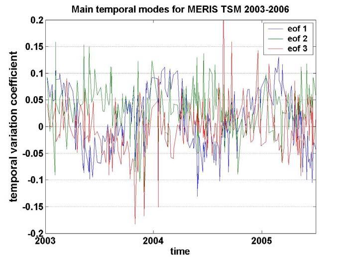
4 DINEOF: principle EOF decomposition DINEOF field reconstruction Spatial Modes Temporal Modes (illustrated for MERIS TSM 2003 data on the North Sea)
5 1 col. = 1 image DINEOF X = U S V 1- EOF decomposition (iterations) 2- General Cross Validation Optimal nb. of EOFs N 3- Final SVD decomposition m pixels/image (sp. dim.) n images ( temp.dim ) = k singular values k sp. EOFfs n (temporal ( dimension k tp. EOFs

6 The BELCOLOUR-1 database The North Sea Belcolour-1 database: Daily frequency 1km resolution Parameters : Chl.a, TSM, Flag for MERIS, MODIS, SeaWifs + SST for MODIS Some statistics on the channel area : 48.5 N-52.5 N 4 W-5 E; Sensor MERIS MODIS SeaWifs Period 01/03-12/06 07/02-12/06 09/97-12/04 Images Mean interval (days) Data points 34 * 10E6 185 * 10E6 57 * 10E6 Missing data %
7


8 MERIS TSM
9
10
11

12

13


14 Outliers and Error fields


15 Outliers: plane track spotted?

16 Outliers: probable clouds, haze area?
17 MERIS CHL


18 CEFAS buoy West G Scheelde turbidity maximum

19
20

21 Clear outliers observed at cloud edges

22 Clear outliers observed at cloud edges


23 Outliers: filtering well, a complex target


24 Outliers: filtering well, a complex target

25 MODIS TSM

26
27 MODIS SST

28
29 Monthly climatologies : MERIS CHL MODIS TSM MODIS SST
30 CONCLUSIONS Promising DINEOF applications to satellite optical data! (4,5 years of MODIS SST data 13 EOFs; varex = 98,0 %) 4 years of MERIS TSM data 18 EOFs; varex = 97,2 % 4 years of MERIS CHL data 8 EOFs; varex = 93,5 % 4,5 years of MODIS TSM data 14 EOFs; varex = 97,5 % DINEOF Advantages : -> parameter free -> synthetized description of the dominant dynamic -> pointing out «unusal data» as outliers (pixel/images) improve data quality provides efficient insigth into large databases - > estimation of correlation length of the observational error
31 PROBLEMS and PERSPECTIVES Spikes in reconstruction and unconsistent reconstructions: Eliminate outlying data and images before second DINEOF cycle Raise the minimal required presence of data per image Excessive filtering? To which extent DINEOF distinguishes noise from small scale natural processes? Combine DINEOF and DIVA (Data Interpolating Variational Analysis) to reduce filtering Comparison of DINEOF products with DIVA and various O.I. methods Multivariate analysis of TSM data with hydrodynamic model data Forecast from present data by using combined time lagged data
32 Thanks for attention! Acknowlegments: To the GHER and MUMM teams for their teaching and support RECOLOUR project was funded by the Belgian Science Policy (BELSPO) MERIS DATA was provided by ESA Links : GHER-ULG : MUMM - RBINS :
33
34
35
36
37 Summary of DINEOF related Products: Filled database Spatio-temporal EOF patterns Belcolour - 1 Database DINEOF Gridded fields at regular time-steps Extraction of multitemporal averages => data time series at specific locations Error maps of each analysis Maps of suspicious pixels
38 DINEOF 1- EOF decomposition A SVD decomposition with k eofs data matrix: ( X=X-mean(X missing data set to 0 (first guess), flagged X = U S V replace missing data until convergence B Repeat previous step for k=1:kmax kmax estimates of missing data 2- General Cross Validation Optimal Numbers of EOFs N 3- Final SVD decomposition of all data into N modes Reference DINEOF publication: Alvera-Azcárate et. al, Ocean Modelling, 9, , Beckers et al, Ocean Sciences, 2: , 2006


39
40 MODIS TSM

41 Outliers: probable cloud shadows or undetected cloud edges


42 Outliers: probable cloud shadows or undetected cloud edges

43 Outliers: probable cloud shadows or undetected cloud edges


44 Outliers and filtering.. : western channel bloom as consistent feature, but coastal spots of extreme low values partly classified as outliers
45 PROBLEMS: avoiding pollution of regular time step reconstructions and multitemporal averages by senseless reconstructions due to bad data
46
Data Interpolating Empirical Orthogonal Functions (DINEOF): a tool for geophysical data analyses.
: a tool for geophysical data analyses.") Data Interpolating Empirical Orthogonal Functions (DINEOF): a tool for geophysical data analyses. Aida Alvera-Azcárate a,b,, Alexander Barth a,b, Damien Sirjacobs a, Fabian Lenartz a, Jean-Marie Beckers
Data Interpolating Empirical Orthogonal Functions (DINEOF): a tool for geophysical data analyses. Aida Alvera-Azcárate a,b,, Alexander Barth a,b, Damien Sirjacobs a, Fabian Lenartz a, Jean-Marie Beckers
Data Interpolating Empirical Orthogonal Functions (DINEOF): a tool for geophysical data analyses
: a tool for geophysical data analyses") Mediterranean Marine Science Indexed in WoS (Web of Science, ISI Thomson) and SCOPUS The journal is available on line at http://www.medit-mar-sc.net Paper presented at the International Conference on Marine
Mediterranean Marine Science Indexed in WoS (Web of Science, ISI Thomson) and SCOPUS The journal is available on line at http://www.medit-mar-sc.net Paper presented at the International Conference on Marine
Filling in Missing Sea-Surface Temperature Satellite Data Over The Eastern Mediterranean Sea Using the DINEOF Algorithm
 Cent. Eur. J. Geosci. 6(1) 2014 27-41 DOI: 10.2478/s13533-012-0148-1 Central European Journal of Geosciences Filling in Missing Sea-Surface Temperature Satellite Data Over The Eastern Mediterranean Sea
TOTAL SUSPENDED MATTER MAPS FROM CHRIS IMAGERY OF A SMALL INLAND WATER BODY IN OOSTENDE (BELGIUM)
") TOTAL SUSPENDED MATTER MAPS FROM IMAGERY OF A SMALL INLAND WATER BODY IN OOSTENDE (BELGIUM) Barbara Van Mol (1) and Kevin Ruddick (1) (1) Management Unit of the North Sea Mathematical Models (MUMM), Royal
TOTAL SUSPENDED MATTER MAPS FROM IMAGERY OF A SMALL INLAND WATER BODY IN OOSTENDE (BELGIUM) Barbara Van Mol (1) and Kevin Ruddick (1) (1) Management Unit of the North Sea Mathematical Models (MUMM), Royal
Enhancing temporal correlations in EOF expansions for the reconstruction of missing data using DINEOF
 Ocean Sci., 5, 475 485, 2009 Author(s) 2009. This work is distributed under the Creative Commons Attribution 3.0 License. Ocean Science Enhancing temporal correlations in EOF expansions for the reconstruction
Images Reconstruction using an iterative SOM based algorithm.
 Images Reconstruction using an iterative SOM based algorithm. M.Jouini 1, S.Thiria 2 and M.Crépon 3 * 1- LOCEAN, MMSA team, CNAM University, Paris, France 2- LOCEAN, MMSA team, UVSQ University Paris, France
DIVA. Overview. Jean-Marie Beckers and GHER-DIVA group Aida Alvera, Alexander Barth, Charles Troupin, Mohamed Ouberdous, Sylvain Watelet
 DIVA Overview Jean-Marie Beckers and -DIVA group Aida Alvera, Alexander Barth, Charles Troupin, Mohamed Ouberdous, Sylvain Watelet http://modb.oce.ulg.ac.be/ MARE- Sart-Tilman B5 4000 Liège, Belgique p.
An Operational Interpolated Ocean Colour Product in the Mediterranean Sea
 CHAPTER 9 An Operational Interpolated Ocean Colour Product in the Mediterranean Sea Gianluca Volpe 1, Bruno Buongiorno Nardelli 1,2, Simone Colella 1, Andrea Pisano 1, and Rosalia Santoleri 1 1 Istituto
OceanBrowser: on-line visualization of gridded ocean data and in situ observations
 OceanBrowser: on-line visualization of gridded ocean data and in situ observations Alexander Barth¹, Sylvain Watelet¹, Charles Troupin², Aida Alvera Azcarate¹, Giorgio Santinelli³, Gerrit Hendriksen³,
DIVA: updates and new potential for improving SDC data products
 DIVA: updates and new potential for improving SDC data products Alexander Barth, Charles Troupin, Sylvain Watelet, Aida Alvera-Azcárate, and Jean-Marie Beckers GHER, University of Liège, Belgium GeoHydrodynamics
Spatial Variation of Sea-Level Sea level reconstruction
 Spatial Variation of Sea-Level Sea level reconstruction Biao Chang Multimedia Environmental Simulation Laboratory School of Civil and Environmental Engineering Georgia Institute of Technology Advisor:
Alexander Barth, Aida Alvera-Azcárate, Mohamed Ouberdous, Charles Troupin, Sylvain Watelet & Jean-Marie Beckers
 Diva workshop 2014 Diva in 4 dimensions (GODIVA) Alexander Barth, Aida Alvera-Azcárate, Mohamed Ouberdous, Charles Troupin, Sylvain Watelet & Jean-Marie Beckers Acknowledgements: SeaDataNet, EMODnet Chemistry,
Gap-Filling of Solar Wind Data by Singular Spectrum Analysis
 Gap-Filling of Solar Wind Data by Singular Spectrum Analysis Dmitri Kondrashov University of California, Los Angeles Yuri Shprits University of California, Los Angeles Motivation 1. Observational data
The NIR- and SWIR-based On-orbit Vicarious Calibrations for VIIRS
 The NIR- and SWIR-based On-orbit Vicarious Calibrations for VIIRS Menghua Wang NOAA/NESDIS/STAR E/RA3, Room 3228, 5830 University Research Ct. College Park, MD 20746, USA Menghua.Wang@noaa.gov Workshop
OCEAN COLOUR REMOTE SENSING OF EXTREME CASE-2 WATERS
 OCEAN COLOUR REMOTE SENSING OF EXTREME CASE-2 WATERS Martin Hieronymi (1), Hajo Krasemann (1), Dagmar Müller (1), Carsten Brockmann (2), Ana Ruescas (2), Kerstin Stelzer (2), Bouchra Nechad (3), Kevin
MERIS US Workshop. Vicarious Calibration Methods and Results. Steven Delwart
 MERIS US Workshop Vicarious Calibration Methods and Results Steven Delwart Presentation Overview Recent results 1. CNES methods Deserts, Sun Glint, Rayleigh Scattering 2. Inter-sensor Uyuni 3. MOBY-AAOT
Improved Global Ocean Color using POLYMER Algorithm
 Improved Global Ocean Color using POLYMER Algorithm François Steinmetz 1 Didier Ramon 1 Pierre-Yves Deschamps 1 Jacques Stum 2 1 Hygeos 2 CLS June 29, 2010 ESA Living Planet Symposium, Bergen, Norway c
SOM+EOF for Finding Missing Values
 SOM+EOF for Finding Missing Values Antti Sorjamaa 1, Paul Merlin 2, Bertrand Maillet 2 and Amaury Lendasse 1 1- Helsinki University of Technology - CIS P.O. Box 5400, 02015 HUT - Finland 2- Variances and
Uncertainties in the Products of Ocean-Colour Remote Sensing
 Chapter 3 Uncertainties in the Products of Ocean-Colour Remote Sensing Emmanuel Boss and Stephane Maritorena Data products retrieved from the inversion of in situ or remotely sensed oceancolour data are
Inter-comparison of SEVIRI/MSG and MERIS/ENVISAT biophysical products over Europe and Africa
 Inter-comparison of SEVIRI/MSG and MERIS/ENVISAT biophysical products over Europe and Africa F.J. García-Haro, F. Camacho-de Coca, J. Meliá University of Valencia Remote Sensing Unit EOLAB Universitat
VALIDATION OF MERIS REMOTE SENSING REFLECTANCE IN ATLANTIC CASE 1 WATERS WITH GROUND BASED IN-SITU MEASUREMENTS
 VALIDATION OF MERIS REMOTE SENSING REFLECTANCE IN ATLANTIC CASE 1 WATERS WITH GROUND BASED IN-SITU MEASUREMENTS Anja Theis(1), Bettina Schmitt(1), Steffen Gehnke(), Roland Doerffer(), Astrid Bracher(1)
Breakout session: Active Remote Sensing for Ocean Colour
 Breakout session: Active Remote Sensing for Ocean Colour Jamet, C. Laboratoire d Océanologie et de Géosciences, Wimereux, France Churnside, J. NOAA, Boulder, USA Hostetler, C. NASA, Langley, USA Passive
CHARACTERIZATION OF OCEAN SUBMESOSCALE TURBULENCE REGIMES FROM SATELLITE OBSERVATIONS OF SEA SURFACE TEMPERATURES
 Submesoscale Processes: Mechanisms, Implications and new Frontiers CHARACTERIZATION OF OCEAN SUBMESOSCALE TURBULENCE REGIMES FROM SATELLITE OBSERVATIONS OF SEA SURFACE TEMPERATURES J. Isern-Fontanet, A.
Geometric Accuracy Evaluation, DEM Generation and Validation for SPOT-5 Level 1B Stereo Scene
 Geometric Accuracy Evaluation, DEM Generation and Validation for SPOT-5 Level 1B Stereo Scene Buyuksalih, G.*, Oruc, M.*, Topan, H.*,.*, Jacobsen, K.** * Karaelmas University Zonguldak, Turkey **University
3 Selecting the standard map and area of interest
 Anomalies, EOF/PCA Mati Kahru 2005-2008 1 Anomalies, EOF/PC analysis with WAM 1 Introduction Calculating anomalies is a method of change detection in time series. Empirical Orthogonal Function (EOF) analysis
Validation of inferred high resolution ocean pco2 and air-sea fluxes with in-situ and remote sensing data.
 Validation of inferred high resolution ocean pco2 and air-sea fluxes with in-situ and remote sensing data. Ismael Hernandez, Hussein Yahia, Joël Sudre, Véronique Garçon, Christoph Garbe, Boris Dewitte,
BOUSSOLE DATA PROCESSING
 BOUSSOLE DATA PROCESSING D. Antoine, B. Gentili, E. Leymarie V. Vellucci OUTLINE OUTLINE > Preprocessing conversion to physical units dark subtraction data reduction > Processing conversion to physical
OCEANSAT-2 OCEAN COLOUR MONITOR (OCM-2)
") OCEANSAT-2 OCEAN COLOUR MONITOR (OCM-2) Update of post launch vicarious, lunar calibrations & current status Presented by Prakash Chauhan Space Applications Centre Indian Space Research Organistaion Ahmedabad-
OCEANSAT-2 OCEAN COLOUR MONITOR (OCM-2) Update of post launch vicarious, lunar calibrations & current status Presented by Prakash Chauhan Space Applications Centre Indian Space Research Organistaion Ahmedabad-
Exercises with Level-2 satellite data
 Exercises with Level-2 satellite data Mati Kahru WimSoft, http://www.wimsoft.com Email: wim@wimsoft.com & Scripps Institution of Oceanography UCSD, La Jolla, CA 92093-0218, USA mkahru@ucsd.edu 24-Jan-15
Spatial Distributions of Precipitation Events from Regional Climate Models
 Spatial Distributions of Precipitation Events from Regional Climate Models N. Lenssen September 2, 2010 1 Scientific Reason The Institute of Mathematics Applied to Geosciences (IMAGe) and the National
Modeling of the ageing effects on Meteosat First Generation Visible Band
 on on Meteosat First Generation Visible Band Ilse Decoster, N. Clerbaux, J. Cornelis, P.-J. Baeck, E. Baudrez, S. Dewitte, A. Ipe, S. Nevens, K. J. Priestley, A. Velazquez Royal Meteorological Institute
Spatial and multi-scale data assimilation in EO-LDAS. Technical Note for EO-LDAS project/nceo. P. Lewis, UCL NERC NCEO
 Spatial and multi-scale data assimilation in EO-LDAS Technical Note for EO-LDAS project/nceo P. Lewis, UCL NERC NCEO Abstract Email: p.lewis@ucl.ac.uk 2 May 2012 In this technical note, spatial data assimilation
Time Series Prediction as a Problem of Missing Values: Application to ESTSP2007 and NN3 Competition Benchmarks
 Series Prediction as a Problem of Missing Values: Application to ESTSP7 and NN3 Competition Benchmarks Antti Sorjamaa and Amaury Lendasse Abstract In this paper, time series prediction is considered as
Assimilation. Project Team INRIA MOISE Laboratoire Jean Kuntzmann Grenoble, France ADDISA ANR project.
 Operators in Image of Pseudo-s Innocent Souopgui, Olivier In collaboration with F.-X. Le Dimet and A. Vidard Project Team INRIA MOISE Laboratoire Jean Kuntzmann Grenoble, France ANR project http://addisa.gforge.inria.fr
MAPPING OF CHLOROPHYLL AND SUSPENDED PARTICULATE MATTER MAPS FROM CHRIS IMAGERY OF THE OOSTENDE CORE SITE
 MAPPING OF CHLOROPHYLL AND SUSPENDED PARTICULATE MATTER MAPS FROM CHRIS IMAGERY OF THE OOSTENDE CORE SITE Barbara Van Mol, Young-Je Par, Kevin Ruddic, Bouchra Nechad Management Unit of the North Sea Mathematical
Calibration of IRS-1C PAN-camera
 Calibration of IRS-1C PAN-camera Karsten Jacobsen Institute for Photogrammetry and Engineering Surveys University of Hannover Germany Tel 0049 511 762 2485 Fax -2483 Email karsten@ipi.uni-hannover.de 1.
3. Data Structures for Image Analysis L AK S H M O U. E D U
 3. Data Structures for Image Analysis L AK S H M AN @ O U. E D U Different formulations Can be advantageous to treat a spatial grid as a: Levelset Matrix Markov chain Topographic map Relational structure
P-spline ANOVA-type interaction models for spatio-temporal smoothing
 P-spline ANOVA-type interaction models for spatio-temporal smoothing Dae-Jin Lee and María Durbán Universidad Carlos III de Madrid Department of Statistics IWSM Utrecht 2008 D.-J. Lee and M. Durban (UC3M)
Exercises with Level-2 satellite data
 Exercises with Level-2 satellite data Mati Kahru WimSoft, http://www.wimsoft.com Email: wim@wimsoft.com also at Scripps Institution of Oceanography UCSD, La Jolla, CA 92093-0218, USA mkahru@ucsd.edu 10/25/2008
Regional MERIS level 2 algal products
 Regional MERIS level 2 algal products Development and validation in the Skagerrak Sea and Norwegian coastal waters Kai Sørensen 1, Jan Magnusson 1, Jo Høkedal 1, Eyvind Aas 2, Roland Doerffer 3, Carsten
STRATEGIES FOR ALTERNATE APPROACHES FOR VEGETATION INDICES COMPOSITING USING PARALLEL TEMPORAL MAP ALGEBRA
 STRATEGIES FOR ALTERNATE APPROACHES FOR VEGETATION INDICES COMPOSITING USING PARALLEL TEMPORAL MAP ALGEBRA Bijay Shrestha, Dr. Charles O Hara Dr. Nicholas H. Younan Mississippi State University OUTLINE
How to Use GOCE Level 2 Products
 How to Use GOCE Level 2 Products Thomas Gruber 1), Reiner Rummel 1), Radboud Koop 2) 1) Institute of Astronomical and Physical Geodesy, Technical University Munich 2) Netherlands Institute for Space Research
GEOMETRIC POTENTIAL OF IRS-1 C PAN-CAMERA. Jacobsen, Karsten University of Hannover
 GEOMETRIC POTENTIAL OF IRS-1 C PAN-CAMERA Jacobsen, Karsten University of Hannover Email: karsten@ipi.uni-hannover.de KEY WORDS: Geometry, IRS1-C, block adjustment ABSTRACT: IRS-1 C images with optimal
A Multiscale Nested Modeling Framework to Simulate the Interaction of Surface Gravity Waves with Nonlinear Internal Gravity Waves
 DISTRIBUTION STATEMENT A. Approved for public release; distribution is unlimited. A Multiscale Nested Modeling Framework to Simulate the Interaction of Surface Gravity Waves with Nonlinear Internal Gravity
BODY / SYSTEM Specifically, the website consists of the following pages:
 GULF OF MEXICO MODELING SYSTEM WEBSITE http://www7330.nrlssc.navy.mil/gomms/index.html R. Holladay*, S. Holladay*, S. derada Naval Research Laboratory, Stennis Space Center, MS, USA *Student Intern SUMMARY
IMAGE CLASSIFICATION USING COMPETITIVE NEURAL NETWORKS
 IMAGE CLASSIFICATION USING COMPETITIVE NEURAL NETWORKS V. Musoko, M. Kolı nova, A. Procha zka Institute of Chemical Technology, Department of Computing and Control Engineering Abstract The contribution
Calibration Techniques for NASA s Remote Sensing Ocean Color Sensors
 Calibration Techniques for NASA s Remote Sensing Ocean Color Sensors Gerhard Meister, Gene Eplee, Bryan Franz, Sean Bailey, Chuck McClain NASA Code 614.2 Ocean Biology Processing Group October 21st, 2010
SENSITIVITY ANALYSIS OF SEMI-ANALYTICAL MODELS OF DIFFUSE ATTENTUATION OF DOWNWELLING IRRADIANCE IN LAKE BALATON
 SENSITIVITY ANALYSIS OF SEMI-ANALYTICAL MODELS OF DIFFUSE ATTENTUATION OF DOWNWELLING IRRADIANCE IN LAKE BALATON Van der Zande D. (1), Blaas M. (2), Nechad B. (1) (1) Royal Belgian Institute of Natural
PLEASE SCROLL DOWN FOR ARTICLE
 This article was downloaded by: [University of New Hampshire] On: 28 July 2009 Access details: Access Details: [subscription number 906455797] Publisher Taylor & Francis Informa Ltd Registered in England
Data Mining Support for Aerosol Retrieval and Analysis:
 Data Mining Support for Aerosol Retrieval and Analysis: Our Approach and Preliminary Results Zoran Obradovic 1 joint work with Amy Braverman 2, Bo Han 1, Zhanqing Li 3, Yong Li 1, Kang Peng 1, Yilian Qin
3D Modeling from Range Images
 1 3D Modeling from Range Images A Comprehensive System for 3D Modeling from Range Images Acquired from a 3D ToF Sensor Dipl.-Inf. March 22th, 2007 Sensor and Motivation 2 3D sensor PMD 1k-S time-of-flight
SEA SURFACE SPEED FROM TERRASAR-X ATI DATA
 SEA SURFACE SPEED FROM TERRASAR-X ATI DATA Matteo Soccorsi (1) and Susanne Lehner (1) (1) German Aerospace Center, Remote Sensing Technology Institute, 82234 Weßling, Germany, Email: matteo.soccorsi@dlr.de
Feature Tracking and Optical Flow
 Feature Tracking and Optical Flow Prof. D. Stricker Doz. G. Bleser Many slides adapted from James Hays, Derek Hoeim, Lana Lazebnik, Silvio Saverse, who 1 in turn adapted slides from Steve Seitz, Rick Szeliski,
Anisotropic Methods for Image Registration
 Anisotropic Methods for Image Registration James Murphy November 24, 2014 () November 24, 2014 1 / 37 Goals of Talk 1 Explain the problem of image registration. 2 Discuss existing methods for image registration,
EE795: Computer Vision and Intelligent Systems
 EE795: Computer Vision and Intelligent Systems Spring 2012 TTh 17:30-18:45 FDH 204 Lecture 14 130307 http://www.ee.unlv.edu/~b1morris/ecg795/ 2 Outline Review Stereo Dense Motion Estimation Translational
Seawater reflectance in the near-ir
 Seawater reflectance in the near-ir Maéva DORON David DOXARAN Simon BELANGER Marcel BABIN Laboratoire d'océanographie de Villefranche Seawater Reflectance in the Near-IR Doron, Doxaran, Bélanger & Babin
WHAT IS REMOTE SENSING?
 How Does Artificial Intelligence Work with Remote Sensing Technologies for Multi-scale Environmental Change Detection? Prof. Ni-Bin Chang Director, Stormwater Management Academy University of Central Florida
Definition, test and evaluation of a monthly composite product for Sentinel-2, based on SPOT4 (Take5)
") SPOT4/Take5 User Workshop 18-11-2014, test and evaluation of a monthly composite product for Sentinel-2, Kadiri Mohamed (THEIA), Olivier Hagolle (CNES), Mireille Huc (CNRS/CESBIO), D. Morin (S2AGRI) 1
SPOT4/Take5 User Workshop 18-11-2014, test and evaluation of a monthly composite product for Sentinel-2, Kadiri Mohamed (THEIA), Olivier Hagolle (CNES), Mireille Huc (CNRS/CESBIO), D. Morin (S2AGRI) 1
Evolutions during year 2011
 Evolutions during year 2011 Constant Mazeran 1, Christophe Lerebourg 1, Kathryn Barker 2, Olivier Sardou 1, Chris Kent 2, Philippe Goryl 3 (1) ACRI-ST, 260 route du Pin Montard, Sophia Antipolis, 06600,
Status and description of Level 2 products and algorithm (salinity)
") SMOS 7th Workshop, ESRIN, Frascati, 29-31 Oct. 2007 Status and description of Level 2 products and algorithm (salinity) J. Font, J. Boutin, N. Reul, P. Waldteufel, C. Gabarró, S. Zine, J. Tenerelli, M.
SMOS 7th Workshop, ESRIN, Frascati, 29-31 Oct. 2007 Status and description of Level 2 products and algorithm (salinity) J. Font, J. Boutin, N. Reul, P. Waldteufel, C. Gabarró, S. Zine, J. Tenerelli, M.
Uncertainties in ocean colour remote sensing
 NOWPAP / PICES / WESTPAC Joint Training Course on Remote Sensing Data Analysis Introduction and recent progress in ocean color remote sensing part I: Uncertainties in ocean colour remote sensing Roland
BATHYMETRIC EXTRACTION USING WORLDVIEW-2 HIGH RESOLUTION IMAGES
 BATHYMETRIC EXTRACTION USING WORLDVIEW-2 HIGH RESOLUTION IMAGES M. Deidda a, G. Sanna a a DICAAR, Dept. of Civil and Environmental Engineering and Architecture. University of Cagliari, 09123 Cagliari,
a ESRIN Via Galileo Galilei - Casella Postale Frascati - Italy Tel. (39) Fax (39)
 Fax (39)") D O C U M E N T document title/ titre du document UIDELINES FOR THE SUBMISSION OF EGISTRATIONS prepared by/préparé par ESA EO R&D Section reference/réference issue/édition 5 revision/révision 1 date of
D O C U M E N T document title/ titre du document UIDELINES FOR THE SUBMISSION OF EGISTRATIONS prepared by/préparé par ESA EO R&D Section reference/réference issue/édition 5 revision/révision 1 date of
EECS 556 Image Processing W 09
 EECS 556 Image Processing W 09 Motion estimation Global vs. Local Motion Block Motion Estimation Optical Flow Estimation (normal equation) Man slides of this lecture are courtes of prof Milanfar (UCSC)
Real-Time Model-Free Detection of Low-Quality Synchrophasor Data
 Real-Time Model-Free Detection of Low-Quality Synchrophasor Data Meng Wu and Le Xie Department of Electrical and Computer Engineering Texas A&M University College Station, TX NASPI Work Group meeting March
NASA e-deep Blue aerosol update: MODIS Collection 6 and VIIRS
 NASA e-deep Blue aerosol update: MODIS Collection 6 and VIIRS Andrew M. Sayer, N. Christina Hsu (PI), Corey Bettenhausen, Nick Carletta, Jaehwa Lee, Colin Seftor, Jeremy Warner Past team members: Ritesh
Oceanographic Features Selection to Predict the Tuna Potential Fishing Zones Using SFFS Method
 International Mathematical Forum, Vol. 11, 2016, no. 24, 1157-1166 HIKARI Ltd, www.m-hikari.com https://doi.org/10.12988/imf.2016.611145 Oceanographic Features Selection to Predict the Tuna Potential Fishing
PART I: Collecting data from National Earth Observatory
 Investigation: Sea Surface Temperature We ve seen how temperature varies with depth, but how does it vary with latitude and season? In this investigation, you are going to explore sea surface temperatures
Gridded Data Speedwell Derived Gridded Products
 Gridded Data Speedwell Derived Gridded Products Introduction Speedwell Weather offers access to a wide choice of gridded data series. These datasets are sourced from the originating agencies in their native
Human Detection. A state-of-the-art survey. Mohammad Dorgham. University of Hamburg
 Human Detection A state-of-the-art survey Mohammad Dorgham University of Hamburg Presentation outline Motivation Applications Overview of approaches (categorized) Approaches details References Motivation
SPOT VGT.
 SPOT VGT http://www.spot-vegetation.com/ SPOT VGT General Information Resolution: 1km Projection: Unprojected, Plate Carree Geodetic system: WGS 1984 Geographic Extent Latitude: 75 o N to 56 o S Longitude:
Vega Forneris, Cristina Tronconi, Gianluca Volpe, Simone Colella, Bruno B. Nardelli, Andrea Pisano, Rosalia Santoleri IMDIS
 The CNR-ISAC Informatics Infrastructure for the Satellite Climatological and Oceanographic data: production, harmonization and dissemination in Interoperability Frameworks Vega Forneris, Cristina Tronconi,
QUALITY CONTROL FOR UNMANNED METEOROLOGICAL STATIONS IN MALAYSIAN METEOROLOGICAL DEPARTMENT
 QUALITY CONTROL FOR UNMANNED METEOROLOGICAL STATIONS IN MALAYSIAN METEOROLOGICAL DEPARTMENT By Wan Mohd. Nazri Wan Daud Malaysian Meteorological Department, Jalan Sultan, 46667 Petaling Jaya, Selangor,
Supplement of Sea-surface dimethylsulfide (DMS) concentration from satellite data at global and regional scales
 concentration from satellite data at global and regional scales") Supplement of Biogeosciences, 15, 3497 3519, 2018 https://doi.org/10.5194/bg-15-3497-2018-supplement Author(s) 2018. This work is distributed under the Creative Commons Attribution 4.0 License. Supplement
Supplement of Biogeosciences, 15, 3497 3519, 2018 https://doi.org/10.5194/bg-15-3497-2018-supplement Author(s) 2018. This work is distributed under the Creative Commons Attribution 4.0 License. Supplement
DATA FUSION, DE-NOISING, AND FILTERING TO PRODUCE CLOUD-FREE TEMPORAL COMPOSITES USING PARALLEL TEMPORAL MAP ALGEBRA
 DATA FUSION, DE-NOISING, AND FILTERING TO PRODUCE CLOUD-FREE TEMPORAL COMPOSITES USING PARALLEL TEMPORAL MAP ALGEBRA Bijay Shrestha Dr. Charles O Hara Preeti Mali GeoResources Institute Mississippi State
Uncertainties in ocean colour remote sensing
 ENMAP Summer School on Remote Sensing Data Analysis Uncertainties in ocean colour remote sensing Roland Doerffer Retired from Helmholtz Zentrum Geesthacht Institute of Coastal Research Now: Brockmann Consult
Constraining Rainfall Replicates on Remote Sensed and In-Situ Measurements
 Constraining Rainfall Replicates on Remote Sensed and In-Situ Measurements Seyed Hamed Alemohammad, Dara Entekhabi, Dennis McLaughlin Ralph M. Parsons Laboratory for Environmental Science and Engineering
Operational use of the Orfeo Tool Box for the Venµs Mission
 Operational use of the Orfeo Tool Box for the Venµs Mission Thomas Feuvrier http://uk.c-s.fr/ Free and Open Source Software for Geospatial Conference, FOSS4G 2010, Barcelona Outline Introduction of the
Prototyping GOES-R Albedo Algorithm Based on MODIS Data Tao He a, Shunlin Liang a, Dongdong Wang a
 Prototyping GOES-R Albedo Algorithm Based on MODIS Data Tao He a, Shunlin Liang a, Dongdong Wang a a. Department of Geography, University of Maryland, College Park, USA Hongyi Wu b b. University of Electronic
Revision History. Applicable Documents
 Revision History Version Date Revision History Remarks 1.0 2011.11-1.1 2013.1 Update of the processing algorithm of CAI Level 3 NDVI, which yields the NDVI product Ver. 01.00. The major updates of this
L2 Batch Processing script based processing of Level-2 satellite data
 L2 batch processing Mati Kahru 2015 1 L2 Batch Processing script based processing of Level-2 satellite data Contents 1 Introduction... 1 2 Data subscription and processing... 1 3 Preparing the directory
Fourier analysis of low-resolution satellite images of cloud
 New Zealand Journal of Geology and Geophysics, 1991, Vol. 34: 549-553 0028-8306/91/3404-0549 $2.50/0 Crown copyright 1991 549 Note Fourier analysis of low-resolution satellite images of cloud S. G. BRADLEY
Ice Cover and Sea and Lake Ice Concentration with GOES-R ABI
 GOES-R AWG Cryosphere Team Ice Cover and Sea and Lake Ice Concentration with GOES-R ABI Presented by Yinghui Liu 1 Team Members: Yinghui Liu 1, Jeffrey R Key 2, and Xuanji Wang 1 1 UW-Madison CIMSS 2 NOAA/NESDIS/STAR
DIAS_Satellite_MODIS_SurfaceReflectance dataset
 DIAS_Satellite_MODIS_SurfaceReflectance dataset 1. IDENTIFICATION INFORMATION DOI Metadata Identifier DIAS_Satellite_MODIS_SurfaceReflectance dataset doi:10.20783/dias.273 [http://doi.org/10.20783/dias.273]
Projet PNTS SPACTO. SPatial Atmospheric Correction over Turbid Ocean. Julien Brajard
 Projet PNTS SPACTO SPatial Atmospheric Correction over Turbid Ocean Julien Brajard Outline Context Achievements Perpectives Context Signal measured by the radiometer water-leaving reflectance Atmospheric
Monte Carlo Method for Solving Inverse Problems of Radiation Transfer
 INVERSE AND ILL-POSED PROBLEMS SERIES Monte Carlo Method for Solving Inverse Problems of Radiation Transfer V.S.Antyufeev. ///VSP/// UTRECHT BOSTON KÖLN TOKYO 2000 Contents Chapter 1. Monte Carlo modifications
Region Weighted Satellite Super-resolution Technology
 Region Weighted Satellite Super-resolution Technology Pao-Chi Chang and Tzong-Lin Wu Department of Communication Engineering, National Central University Abstract Super-resolution techniques that process
 AN ANALYSIS OF ITERATIVE ALGORITHMS FOR IMAGE RECONSTRUCTION FROM SATELLITE EARTH REMOTE SENSING DATA Matthew H Willis Brigham Young University, MERS Laboratory 459 CB, Provo, UT 8462 8-378-4884, FAX:
National Satellite Data Centre and Finnish Collaborative GS. Jyri Heilimo Finnish Meteorological Institute Finland Collaborative Ground Stations NCP
 National Satellite Data Centre and Finnish Collaborative GS Jyri Heilimo Finnish Meteorological Institute Finland Collaborative Ground Stations NCP National Satellite Data Center 6.9.2016 National satellite
E. Tilmans ESA C. Baijot - ESA F. Niro -ESA J. Vandenabeele BELSPO. Maisongrande CNES D. Clarijs -VITO W. Dierckx -VITO E.
 Proba V 6 th Quality Working Group (QWG): Summary Report The 6 th Proba-V QWG took place in Redu on 09 th - 10 th Nov, 2017 Partecipants: R. Biasutti - ESA S. Dransfeld - ESA E. Tilmans ESA C. Baijot -
A Robust and Efficient Motion Segmentation Based on Orthogonal Projection Matrix of Shape Space
 A Robust and Efficient Motion Segmentation Based on Orthogonal Projection Matrix of Shape Space Naoyuki ICHIMURA Electrotechnical Laboratory 1-1-4, Umezono, Tsukuba Ibaraki, 35-8568 Japan ichimura@etl.go.jp
Motion and Optical Flow. Slides from Ce Liu, Steve Seitz, Larry Zitnick, Ali Farhadi
 Motion and Optical Flow Slides from Ce Liu, Steve Seitz, Larry Zitnick, Ali Farhadi We live in a moving world Perceiving, understanding and predicting motion is an important part of our daily lives Motion
Image Information Mining (IIM): Where do we go?
: Where do we go?") Image Information Mining (IIM): Where do we go? Klaus Seidel and Mihai Datcu IGARSS 2004 The paradox People have normally trouble in caching more than 7 items at a time We design systems to enable people
Image Information Mining (IIM): Where do we go? Klaus Seidel and Mihai Datcu IGARSS 2004 The paradox People have normally trouble in caching more than 7 items at a time We design systems to enable people
CS231A Midterm Review. Friday 5/6/2016
 CS231A Midterm Review Friday 5/6/2016 Outline General Logistics Camera Models Non-perspective cameras Calibration Single View Metrology Epipolar Geometry Structure from Motion Active Stereo and Volumetric
MODIS Atmosphere: MOD35_L2: Format & Content
 Page 1 of 9 File Format Basics MOD35_L2 product files are stored in Hierarchical Data Format (HDF). HDF is a multi-object file format for sharing scientific data in multi-platform distributed environments.
Adaptive SIOP parameterisation algorithm for complex waters
 NASA-Aqua MODIS January 4 2011 Satellite Chlorophyll estimate Courtesy of Dr. V. Brando, CLW Adaptive SIOP parameterisation algorithm for complex waters Dekker A. G., Brando V. E., Schroeder T., Boldeau-Patissier,
EVALUATION OF CONVENTIONAL DIGITAL CAMERA SCENES FOR THEMATIC INFORMATION EXTRACTION ABSTRACT
 EVALUATION OF CONVENTIONAL DIGITAL CAMERA SCENES FOR THEMATIC INFORMATION EXTRACTION H. S. Lim, M. Z. MatJafri and K. Abdullah School of Physics Universiti Sains Malaysia, 11800 Penang ABSTRACT A study
Online Bad Data Detection for Synchrophasor Systems via Spatio-temporal Correlations
 LOGO Online Bad Data Detection for Synchrophasor Systems via Spatio-temporal s Le Xie Texas A&M University NASPI International Synchrophasor Symposium March 24, 2016 Content 1 Introduction 2 Technical
Notes 9: Optical Flow
 Course 049064: Variational Methods in Image Processing Notes 9: Optical Flow Guy Gilboa 1 Basic Model 1.1 Background Optical flow is a fundamental problem in computer vision. The general goal is to find
Update on S3 SYN-VGT algorithm status PROBA-V QWG 4 24/11/2016
 ACRI-ST S3MPC 2014-2016 Update on S3 SYN-VGT algorithm status PROBA-V QWG 4 24/11/2016 Agenda Continuity with PROBA-V data - Evolution of S3 SYN / Creation of an alternative Proba-V like processing chain