Data Mining Support for Aerosol Retrieval and Analysis:
|
|
|
- Kristopher Morgan
- 5 years ago
- Views:
Transcription

1 Data Mining Support for Aerosol Retrieval and Analysis: Our Approach and Preliminary Results Zoran Obradovic 1 joint work with Amy Braverman 2, Bo Han 1, Zhanqing Li 3, Yong Li 1, Kang Peng 1, Yilian Qin 1, Slobodan Vucetic 1, Qifang Xu 1 1 Temple University, Philadelphia, PA 2 Jet Propulsion Laboratory, Pasadena, CA 3 University of Maryland, MD
2 Outline Understanding Properties of Aerosol Retrievals by Analysis of Integrated Satelite and Ground Based Observations (Han, B., Vucetic, S. and Obradovic, Z., In preparation) Discovering the Major Sources of Correctable Retrieval Error of Deterministic Retrieval Models (Han, B., Obradovic, Z., Li, Z. and Vucetic, S., Proc. Int l Geoscience and Remote Sensing Symp., 2006) Improving Aerosol Retrieval Accuracy by Integrating Multisource MODIS and MISR Data (Xu Q., Obradovic, Z., Han, B., Li, Y., Braverman, A., Vucetic, S. Proc. 8th Int l Conf. Information Fusion, 2005) Integration of Deterministic and Statistical Retrieval Algorithms (Han, B., Vucetic, S., Braverman, A. and Obradovic, Z., Engineering Applications of Artificial Intelligence journal, in press) Facilitating Efficient Retrievals from Arbitrarily Large Datasets (Peng, K., Obradovic, Z. and Vucetic, S. Proc. 16th European Conf. Artificial Intelligence, 2004; Qin, Y. and Obradovic, Z., Proc. 17th European Conf. Artificial Intelligence, in press)
 and aerosol type characterize and quantify the effect of aerosols on Earth s radiation budget Haze over East USA (see more at http://alg.umbc.")
3 AOT Retrieval Problem Aerosol small particles produced from natural and manmade sources multiple types (soil dust, carbonaceous, sulfate, sea salt aerosols) Problem predict (retrieve) aerosol optical thickness (AOT) and aerosol type characterize and quantify the effect of aerosols on Earth s radiation budget Haze over East USA (see more at
4 Satellite-Based Data: MISR and MODIS Given: radiance attributes, spatial-temporal information satellites (NASA Earth Observing System) Terra: Dec Aqua: May 2002 Aura: July 2004 Instruments: MISR: Terra, 9 camera (7 minutes to see a scene by all 9), 4 bands per camera, global coverage 9 days, repeating cycle 16 days, AOT retrieval resolution 17.6km MODIS: Terra and Aqua, 1 camera, 36 wavelengths, global coverage 1 2 days, repeating cycle 16 days, AOT retrieval resolution 10km Goal: long-term global observation and analysis of the land surface, biosphere, solid Earth, atmosphere, and oceans

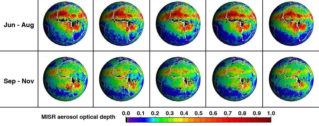
5 Patterns of MISR AOT Retrieval

6 Ground Based AOT Observations: AERONET AERONET (Aerosol Robotic NETwork): a federated international network of sun/sky radiometers at 311 sites, around 40 over U.S. Collects AOT data every 5-15 mins in 10 spectral bands.
7 AOT Retrieval Properties Satellite-based global coverage high spatial resolution low temporal resolution moderately accurate retrieval retrieved by computationally expensive forward simulation algorithm Ground-based limited spatial coverage high temporal resolution more accurate retrieval
8 Objective of Our Study Deterministic retrieval algorithms constructed as inverse operators of high-dimensional nonlinear functions based on lookup tables representing the most common conditions derived from forward-simulation models according to the domain knowledge of aerosol physical properties allow straightforward estimation of retrieval uncertainty Drawbacks of deterministic retrieval algorithms high computational cost due to inversion of nonlinear forward models slow development due to manual construction of the postulated physical models inadequate accuracy due to limited size of constructed look-up table and partial understanding of the complex processes often compromise of accuracy, speed and prior knowledge Objective of Our Study Support aerosol retrieval and analysis by complementing deterministic algorithms through development of data mining methodology that utilizes multi-sensor satellite data of varying quality and ground-truth information
9 Specific Aims of Our Study Determine 1. If analysis of accurate statistical AOT retrievals using integrated satellite and ground observations can improve understanding properties of deterministic AOT retrievals; 2. If data mining can help discovering the major sources of correctable retrieval errors of deterministic retrievals; and 3. If data mining can facilitate development of jointsensor retrieval algorithms that take advantage of aerosol observation from multiple instruments.
10 Our Approach and Preliminary Results Analysis of AOT retrievals by learning relationships between satellite based attributes and ground based AOT observations using: global neural network models; local neural networks and local spatial interpolation models; hybrid statistical models Understanding correctable AOT retrieval errors by learning decision trees to characterize conditions when statistical retrievals are more accurate than model-driven deterministic retrievals Developing joint-sensor retrievals by using attributes derived from MISR and MODIS and a target representing AOT retrieval by AERONET
11 Outline Understanding Properties of Aerosol Retrievals by Analysis of Integrated Satelite and Ground Based Observations (Han, B., Vucetic, S. and Obradovic, Z., In preparation) Discovering the Major Sources of Correctable Retrieval Error of Deterministic Retrieval Models (Han, B., Obradovic, Z., Li, Z. and Vucetic, S., Proc. Int l Geoscience and Remote Sensing Symp., 2006) Improving Aerosol Retrieval Accuracy by Integrating Multisource MODIS and MISR Data (Xu Q., Obradovic, Z., Han, B., Li, Y., Braverman, A., Vucetic, S. Proc. 8th Int l Conf. Information Fusion, 2005) Integration of Deterministic and Statistical Retrieval Algorithms (Han, B., Vucetic, S., Braverman, A. and Obradovic, Z., Engineering Applications of Artificial Intelligence journal, in press) Facilitating Efficient Retrievals from Arbitrarily Large Datasets (Peng, K., Obradovic, Z. and Vucetic, S. Proc. 16th European Conf. Artificial Intelligence, 2004; Qin, Y. and Obradovic, Z., Proc. 17th European Conf. Artificial Intelligence, in press)

12 Integration of MISR and AERONET Data MISR: AOT at resolution 17.6km, radiance at resolution 1.1km. Average cloud-free and high quality (valid) voxels in +/ spatial region 17.6 KM 0.15 in Lat o o 0.15 in Lon 17.6 KM o KM 1.1KM * 1.1KM AERONET: average AOT observations in a time windows AERONET AOT :00 19:00 20:00 21:00 22:00 Time A Collocated Point = Average of MISR attributes in space + Average of AERONET AOT in time

13 Integration of MODIS and AERONET Data MODIS: AOT at resolution 10km, radiance at resolution 5km. Average cloud-free and high quality (valid) voxels in +/ spatial region 0.15 in Lat o 10 KM o 0.15 in Lon 10 KM o KM 5 KM * 5 KM AERONET: average AOT observations in a time windows AERONET AOT :00 19:00 20:00 21:00 22:00 Time A Collocated Point = Average of MODIS attributes in space + Average of AERONET AOT in time
14 Integrated Data and Experimental Protocols Temporal and spatially collocated satellite + ground data over continental US: MISR+AERONET: period MODIS+AERONET: period MISR+MODIS+AERONET: period Leave-one-AERONETsite-out cross validation experiments were performed on these datasets to: Identify influence of relevant attributes to AOT retrieval quality Understand effects of various spatial and temporal aggregation intervals Compare deterministic vs. statistical AOT retrieval properties in time, season, by surface type and other patters


15 Attributes for Learning of AOT Retrieval Trained feedforward networks on data grouped by AERONET sites Evaluated by leave-one-aeronetsite-out cross validation 151/147 MISR Attributes input into ANN training 34/28 MODIS Attributes input into ANN training Large number of attributes curse of dimensionality problem is addressed by sensitivity analysis and PCA

16 Sensitivity Analysis of Neural Networks Objective: Analyze influence of attributes to AOT retrieval accuracy based on change in neural network output given small perturbations in each attribute. Results: The most sensitive attributes for MIST-AERONET and MODIS-AERONET

17 AERONET AOT Correlation to AERONET AOT

18 Correlation to AERONET AOT AERONET AOT
19 Results: Accuracy Comparison MISR/MODIS AOT vs. Neural Network Based Retrievals Correlation and prediction error vs. AERONET AOT for different time windows of data fusion (MISR/MODIS AOT not used at ANN) We didn t count the collocated points with MODIS AOTs out of [0, 4]. MODIS retrieval has a systematic positive bias For AERONET AOT averaging time window of ± 30 mins or ± 60 mins, retrievals were the most accurate (both deterministic and statistical)
20 Results: MISR Error Map The prediction errors were larger in summer, at coast sites and at regions with larger variance of elevation Monthly average of prediction errors ( ANN pred AERONET AOT over AERONET site Notation: Elevation std around a site <= 70m > 70m AOT Error AOT Err > >=AOT Err> >=AOT Err> >=AOT Err> 0.03 AOT Err<=0.03
21 Outline Understanding Properties of Aerosol Retrievals by Analysis of Integrated Satelite and Ground Based Observations (Han, B., Vucetic, S. and Obradovic, Z., In preparation) Discovering the Major Sources of Correctable Retrieval Error of Deterministic Retrieval Models (Han, B., Obradovic, Z., Li, Z. and Vucetic, S., Proc. Int l Geoscience and Remote Sensing Symp., 2006) Improving Aerosol Retrieval Accuracy by Integrating Multisource MODIS and MISR Data (Xu Q., Obradovic, Z., Han, B., Li, Y., Braverman, A., Vucetic, S. Proc. 8th Int l Conf. Information Fusion, 2005) Integration of Deterministic and Statistical Retrieval Algorithms (Han, B., Vucetic, S., Braverman, A. and Obradovic, Z., Engineering Applications of Artificial Intelligence journal, in press) Facilitating Efficient Retrievals from Arbitrarily Large Datasets (Peng, K., Obradovic, Z. and Vucetic, S. Proc. 16th European Conf. Artificial Intelligence, 2004; Qin, Y. and Obradovic, Z., Proc. 17th European Conf. Artificial Intelligence, in press)
22 Decision Tree Analysis For Understanding Retrieval Errors Objective: Use decision tree to analyze the conditions where MISR or MODIS AOT retrievals could be improved by neural network predictions Method: 1. Define a classification problem Positives: MISR/ MODIS Negatives: AOT Otherwise. AERONET MISR/ MODIS AOT AERONET AOT AOT >= σ and >=θ ANN Prediction AERONET AOT σ,ө are selected by considering the discrimination of two AOT retrieval models as well as class balance. For MISR, σ=0.02, Ө=2; For MODIS, σ=0.05, Ө=3 2. Learn decision tree to identify retrieval error rules
23 Results: MISR AOT Correctable Error Discovered by Decision Tree Analysis Decision Rules of MISR-AERONET fusion results In such condition, the percentage of examples which could be improved by ANN prediction -- # of Cloud_free Pixels in the region <= MISR CameraBF_Radiance_672nm_Avg >= MISR CameraAN_Radiance_672nm_Minimum < MISR CameraAN_ViewZenith_Angle < MISR CameraAF_Radiance_866nm_Std < (26%) -- MISR CameraAF_Radiance_866nm_Std>= MISR CameraAA_RelViewAzinith_Angle < (72%) -- MISR CameraAA_RelViewAzinith_Angle >= (25%) Discovered rule: When cloud dominates a region, and MISR radiance and geometric parameters satisfy some conditions, neural network predictions outperform MISR AOT retrievals at 72% of locations.
24 Results: MODIS AOT Correctable Error Discovered by Decision Tree Analysis Decision Rules of MODIS-AERONET fusion results In such condition, the percentage of examples which -- MODIS Minimum Radiance at 470nm < 6.22 (24%) -- MODIS Minimum Radiance at 470nm >= Sensor Zenith Angle < Percentage of Region in Desert < 65% (55%) -- Percentage of Region in Desert >= 65% (80%) -- Sensor Zenith Angle >= (36%) could be improved by ANN prediction Discovered rule: When MODIS minimum radiance at 470nm, sensor zenith angle satisfy some condition, and the region is in desert area, neural network predictions can improve MODIS retrieval at 80% of locations
25 Outline Understanding Properties of Aerosol Retrievals by Analysis of Integrated Satelite and Ground Based Observations (Han, B., Vucetic, S. and Obradovic, Z., In preparation) Discovering the Major Sources of Correctable Retrieval Error of Deterministic Retrieval Models (Han, B., Obradovic, Z., Li, Z. and Vucetic, S., Proc. Int l Geoscience and Remote Sensing Symp., 2006) Improving Aerosol Retrieval Accuracy by Integrating Multisource MODIS and MISR Data (Xu Q., Obradovic, Z., Han, B., Li, Y., Braverman, A., Vucetic, S. Proc. 8th Int l Conf. Information Fusion, 2005) Integration of Deterministic and Statistical Retrieval Algorithms (Han, B., Vucetic, S., Braverman, A. and Obradovic, Z., Engineering Applications of Artificial Intelligence journal, in press) Facilitating Efficient Retrievals from Arbitrarily Large Datasets (Peng, K., Obradovic, Z. and Vucetic, S. Proc. 16th European Conf. Artificial Intelligence, 2004; Qin, Y. and Obradovic, Z., Proc. 17th European Conf. Artificial Intelligence, in press)
26 Results: AOT Retrieval by Integration of Multi-Source Data MISR AOT MISR Attr MODIS AOT MODIS Attr ± ± ± ± ± ± ±0.047 R 2 Accuracy comparison (R 2 ) on 5 16-day cycles: 07/01/ /02/2002, 12/24/ /08/2003 MISR Attr (MODIS Attr) denotes neural network learned on all MisrAeronet (ModisAeronet) attributes excluding the MISR AOT (MODIS AOT) Result: Improved accuracy by integrating MISR and MODIS data (Xu Q., Obradovic, Z., Han, B., Li, Y., Braverman, A., Vucetic, S. Proc. 8th Int l Conf. Information Fusion, 2005)
27 Outline Understanding Properties of Aerosol Retrievals by Analysis of Integrated Satelite and Ground Based Observations (Han, B., Vucetic, S. and Obradovic, Z., In preparation) Discovering the Major Sources of Correctable Retrieval Error of Deterministic Retrieval Models (Han, B., Obradovic, Z., Li, Z. and Vucetic, S., Proc. Int l Geoscience and Remote Sensing Symp., 2006) Improving Aerosol Retrieval Accuracy by Integrating Multisource MODIS and MISR Data (Xu Q., Obradovic, Z., Han, B., Li, Y., Braverman, A., Vucetic, S. Proc. 8th Int l Conf. Information Fusion, 2005) Integration of Deterministic and Statistical Retrieval Algorithms (Han, B., Vucetic, S., Braverman, A. and Obradovic, Z., Engineering Applications of Artificial Intelligence journal, in press) Facilitating Efficient Retrievals from Arbitrarily Large Datasets (Peng, K., Obradovic, Z. and Vucetic, S. Proc. 16th European Conf. Artificial Intelligence, 2004; Qin, Y. and Obradovic, Z., Proc. 17th European Conf. Artificial Intelligence, in press)
28 Integration of Deterministic and Statistical Retrieval Approach: Use deterministic algorithms over a fraction of locations Use these annotations to learn statistical models elsewhere Statistical retrieval algorithms explored Global Neural Network (GANN), Inverse Distance Spatial Interpolation (IDSI), Region-Specific Neural Networks (RSNN), Error Correction Model by IDSI applied to GANN error (ECM), Weighted Averaging Model with global and local components (WAM) F j ( xi, β ) = α j fg ( xi, βg ) + (1 α j ) f j ( xi, β j ) (Han, B., Vucetic, S., Braverman, A., Obradovic, Z. Engineering Application of Artificial Intelligence, in press. )

29 Results: Integration of Deterministic and Statistical MIST AOT Retrievals When learning from low fraction of deterministic AOT retrievals accuracy of integrated retrieaval was increasing nearly linear Accuracy with 10% of deterministic AOT retrievals: WAM the best choice Using deterministic retrieval over only 2% of locations the RMSEstat was about 1.3 times larger than RMSEdet in summer and 1.15 times larger than RMSEdet in fall cycles
30 Outline Understanding Properties of Aerosol Retrievals by Analysis of Integrated Satelite and Ground Based Observations (Han, B., Vucetic, S. and Obradovic, Z., In preparation) Discovering the Major Sources of Correctable Retrieval Error of Deterministic Retrieval Models (Han, B., Obradovic, Z., Li, Z. and Vucetic, S., Proc. Int l Geoscience and Remote Sensing Symp., 2006) Improving Aerosol Retrieval Accuracy by Integrating Multisource MODIS and MISR Data (Xu Q., Obradovic, Z., Han, B., Li, Y., Braverman, A., Vucetic, S. Proc. 8th Int l Conf. Information Fusion, 2005) Integration of Deterministic and Statistical Retrieval Algorithms (Han, B., Vucetic, S., Braverman, A. and Obradovic, Z., Engineering Applications of Artificial Intelligence journal, in press) Facilitating Efficient Retrievals from Arbitrarily Large Datasets (Peng, K., Obradovic, Z. and Vucetic, S. Proc. 16th European Conf. Artificial Intelligence, 2004; Qin, Y. and Obradovic, Z., Proc. 17th European Conf. Artificial Intelligence, in press)
31 Large Scale AOT Retrievals Objective: Learning efficiently statistical retrievals from arbitrarily large data Challenges: Huge and heterogeneous data vs. limited computational resources Approach: Build ensembles and simultaneously adjust sample size and model complexity based on current learning performance Results: Efficient Learning of Neural Network Ensembles from Arbitrarily Large Datasets (Peng, K., Obradovic, Z. and Vucetic, S. Proc. 16th Euro. Conf. Artificial Intelligence) Efficient Learning from Massive Spatial-Temporal Data through Selective Support Vector Propagation (Qin, Y. and Obradovic, Z. Proc. 17th European Conf. Artificial Intelligence, in press) R proposed procedure 0.2 single NN ensemble of 5 NN ensemble of 10 NN H*N *N S E
32 Summary Statistical models based on integrating satellite and ground observations can provide more accurate retrieval than MISR/MODIS AOT retrievals alone Data mining analysis can reveal the conditions when deterministic retrieval can be significantly enhanced Accuracy of AOT retrieval can be improved by integrating data from multiple sources Integration of local and global statistical retrievals is beneficial when combined with deterministic retrievals Efficient statistical retrieval by learning from large stream data is possible
33 Thank You! More information: Contact: Zoran Obradovic, director Information Science and Technology Center Temple University
Efficient Learning from Massive Spatial-Temporal Data through Selective Support Vector Propagation
 526 ECAI 26 G. Brewka et al. (Eds.) IOS Press, 26 26 The authors. All rights reserved. Efficient Learning from Massive Spatial-Temporal Data through Selective Support Vector Propagation Yilian Qin and
Global and Regional Retrieval of Aerosol from MODIS
 Global and Regional Retrieval of Aerosol from MODIS Why study aerosols? CLIMATE VISIBILITY Presented to UMBC/NESDIS June 4, 24 Robert Levy, Lorraine Remer, Yoram Kaufman, Allen Chu, Russ Dickerson modis-atmos.gsfc.nasa.gov
VIIRS Radiance Cluster Analysis under CrIS Field of Views
 VIIRS Radiance Cluster Analysis under CrIS Field of Views Likun Wang, Yong Chen, Denis Tremblay, Yong Han ESSIC/Univ. of Maryland, College Park, MD; wlikun@umd.edu Acknowledgment CrIS SDR Team 2016 CICS
SWIR/VIS Reflectance Ratio Over Korea for Aerosol Retrieval
 Korean Journal of Remote Sensing, Vol.23, No.1, 2007, pp.1~5 SWIR/VIS Reflectance Ratio Over Korea for Aerosol Retrieval Kwon Ho Lee*, Zhangqing Li*, Young Joon Kim** *Earth System Science Interdisciplinary
Aerosol Optical Depth Prediction from Satellite Observations by Multiple Instance Regression
 Aerosol Optical Depth Prediction from Satellite Observations by Multiple Instance Regression Zhuang Wang Vladan Radosavljevic Bo Han Zoran Obradovic Slobodan Vucetic Abstract Aerosols are small airborne
Prototyping GOES-R Albedo Algorithm Based on MODIS Data Tao He a, Shunlin Liang a, Dongdong Wang a
 Prototyping GOES-R Albedo Algorithm Based on MODIS Data Tao He a, Shunlin Liang a, Dongdong Wang a a. Department of Geography, University of Maryland, College Park, USA Hongyi Wu b b. University of Electronic
Improved MODIS Aerosol Retrieval using Modified VIS/MIR Surface Albedo Ratio Over Urban Scenes
 Improved MODIS Aerosol Retrieval using Modified VIS/MIR Surface Albedo Ratio Over Urban Scenes Min Min Oo, Matthias Jerg, Yonghua Wu Barry Gross, Fred Moshary, Sam Ahmed Optical Remote Sensing Lab City
OMAERO README File. Overview. B. Veihelmann, J.P. Veefkind, KNMI. Last update: November 23, 2007
 OMAERO README File B. Veihelmann, J.P. Veefkind, KNMI Last update: November 23, 2007 Overview The OMAERO Level 2 data product contains aerosol characteristics such as aerosol optical thickness (AOT), aerosol
Results of Cross-comparisons using multiple sites
 Results of Cross-comparisons using multiple sites Dave Smith CEOS WGCV IVOS workshop 18-20 Oct 2010 1 Content AATSR Drift Analysis AATSR vs. MERIS comparisons over Deserts Intercomparisons Over Dome-C
A Generic Approach For Inversion And Validation Of Surface Reflectance and Aerosol Over Land: Application To Landsat 8 And Sentinel 2
 A Generic Approach For Inversion And Validation Of Surface Reflectance and Aerosol Over Land: Application To Landsat 8 And Sentinel 2 Eric Vermote NASA Goddard Space Flight Center, Code 619, Greenbelt,
GOES-R AWG Radiation Budget Team: Absorbed Shortwave Radiation at surface (ASR) algorithm June 9, 2010
 algorithm June 9, 2010") GOES-R AWG Radiation Budget Team: Absorbed Shortwave Radiation at surface (ASR) algorithm June 9, 2010 Presented By: Istvan Laszlo NOAA/NESDIS/STAR 1 ASR Team Radiation Budget AT chair: Istvan Laszlo ASR
GOES-R AWG Radiation Budget Team: Absorbed Shortwave Radiation at surface (ASR) algorithm June 9, 2010 Presented By: Istvan Laszlo NOAA/NESDIS/STAR 1 ASR Team Radiation Budget AT chair: Istvan Laszlo ASR
Menghua Wang NOAA/NESDIS/STAR Camp Springs, MD 20746, USA
 Ocean EDR Product Calibration and Validation Plan Progress Report: VIIRS Ocean Color Algorithm Evaluations and Data Processing and Analyses Define a VIIRS Proxy Data Stream Define the required in situ
Challenges with atmospheric corrections over Land
 Challenges with atmospheric corrections over Land Eric Vermote NASA GSFC Code 619 Eric.f.vermote@nasa.gov. A Land Climate Data Record Multi instrument/multi sensor Science Quality Data Records used to
Absolute Calibration Correction Coefficients of GOES Imager Visible Channel: DCC Reference Reflectance with Aqua MODIS C6 Data
 Absolute Calibration Correction Coefficients of GOES Imager Visible Channel: DCC Reference Reflectance with Aqua MODIS C6 Data Fangfang Yu and Xiangqian Wu 01/08/2014 1 Outlines DCC reference reflectance
Motivation. Aerosol Retrieval Over Urban Areas with High Resolution Hyperspectral Sensors
 Motivation Aerosol etrieval Over Urban Areas with High esolution Hyperspectral Sensors Barry Gross (CCNY) Oluwatosin Ogunwuyi (Ugrad CCNY) Brian Cairns (NASA-GISS) Istvan Laszlo (NOAA-NESDIS) Aerosols
Laser Beacon Tracking for High-Accuracy Attitude Determination
 Laser Beacon Tracking for High-Accuracy Attitude Determination Tam Nguyen Massachusetts Institute of Technology 29 th AIAA/USU Conference on Small Satellites SSC15-VIII-2 08/12/2015 Outline Motivation
Estimating land surface albedo from polar orbiting and geostationary satellites
 Estimating land surface albedo from polar orbiting and geostationary satellites Dongdong Wang Shunlin Liang Tao He Yuan Zhou Department of Geographical Sciences University of Maryland, College Park Nov
Hyperspectral Remote Sensing
 Hyperspectral Remote Sensing Multi-spectral: Several comparatively wide spectral bands Hyperspectral: Many (could be hundreds) very narrow spectral bands GEOG 4110/5100 30 AVIRIS: Airborne Visible/Infrared
Land surface VIS/NIR BRDF module for RTTOV-11: Model and Validation against SEVIRI Land SAF Albedo product
 Land surface VIS/NIR BRDF module for -: Model and Validation against SEVIRI Albedo product Jérôme Vidot and Eva Borbas Centre de Météorologie Spatiale, DP/Météo-France, Lannion, France SSEC/CIMSS, Madison,
GRASP Algorithm: Retrieval of the detailed properties of atmospheric aerosol from PARASOL and other sensors
 GRASP Algorithm: Retrieval of the detailed properties of atmospheric aerosol from PARASOL and other sensors Oleg Dubovik (University of Lille-1, CNRS, France) GRASP team: P. Litvinov 1,T. Lapyonok 1, F.
Calibration Techniques for NASA s Remote Sensing Ocean Color Sensors
 Calibration Techniques for NASA s Remote Sensing Ocean Color Sensors Gerhard Meister, Gene Eplee, Bryan Franz, Sean Bailey, Chuck McClain NASA Code 614.2 Ocean Biology Processing Group October 21st, 2010
Application of the SCAPE-M atmospheric correction algorithm to the processing of MERIS data over continental water bodies
 Application of the SCAPE-M atmospheric correction algorithm to the processing of MERIS data over continental water bodies L. Guanter 1, J. A. Domínguez 2, L. Conde 2, A. Ruiz-Verdú 2, V. Estellés 3, R.
NASA e-deep Blue aerosol update: MODIS Collection 6 and VIIRS
 NASA e-deep Blue aerosol update: MODIS Collection 6 and VIIRS Andrew M. Sayer, N. Christina Hsu (PI), Corey Bettenhausen, Nick Carletta, Jaehwa Lee, Colin Seftor, Jeremy Warner Past team members: Ritesh
MERIS US Workshop. Vicarious Calibration Methods and Results. Steven Delwart
 MERIS US Workshop Vicarious Calibration Methods and Results Steven Delwart Presentation Overview Recent results 1. CNES methods Deserts, Sun Glint, Rayleigh Scattering 2. Inter-sensor Uyuni 3. MOBY-AAOT
Exercises with Level-2 satellite data
 Exercises with Level-2 satellite data Mati Kahru WimSoft, http://www.wimsoft.com Email: wim@wimsoft.com also at Scripps Institution of Oceanography UCSD, La Jolla, CA 92093-0218, USA mkahru@ucsd.edu 10/25/2008
2-band Enhanced Vegetation Index without a blue band and its application to AVHRR data
 2-band Enhanced Vegetation Index without a blue band and its application to AVHRR data Zhangyan Jiang*, Alfredo R. Huete, Youngwook Kim, Kamel Didan Department of Soil, Water, and Environmental Science,
DEEP LEARNING TO DIVERSIFY BELIEF NETWORKS FOR REMOTE SENSING IMAGE CLASSIFICATION
 DEEP LEARNING TO DIVERSIFY BELIEF NETWORKS FOR REMOTE SENSING IMAGE CLASSIFICATION S.Dhanalakshmi #1 #PG Scholar, Department of Computer Science, Dr.Sivanthi Aditanar college of Engineering, Tiruchendur
Aerosol Optical Depth Retrieval from Satellite Data in China. Professor Dr. Yong Xue
 Aerosol Optical Depth Retrieval from Satellite Data in China Professor Dr. Yong Xue Research Report Outline Multi-scale quantitative retrieval of Aerosol optical depth (AOD) over land Spatial resolution:
Verification of MSI Low Radiance Calibration Over Coastal Waters, Using AERONET-OC Network
 Verification of MSI Low Radiance Calibration Over Coastal Waters, Using AERONET-OC Network Yves Govaerts and Marta Luffarelli Rayference Radiometric Calibration Workshop for European Missions ESRIN, 30-31
Quality assessment of RS data. Remote Sensing (GRS-20306)
") Quality assessment of RS data Remote Sensing (GRS-20306) Quality assessment General definition for quality assessment (Wikipedia) includes evaluation, grading and measurement process to assess design,
Quality assessment of RS data Remote Sensing (GRS-20306) Quality assessment General definition for quality assessment (Wikipedia) includes evaluation, grading and measurement process to assess design,
GEOG 4110/5100 Advanced Remote Sensing Lecture 2
 GEOG 4110/5100 Advanced Remote Sensing Lecture 2 Data Quality Radiometric Distortion Radiometric Error Correction Relevant reading: Richards, sections 2.1 2.8; 2.10.1 2.10.3 Data Quality/Resolution Spatial
Aerosol Remote Sensing from PARASOL and the A-Train
 Aerosol Remote Sensing from PARASOL and the A-Train J.-F. Léon, D. Tanré, J.-L. Deuzé, M. Herman, P. Goloub, P. Lallart Laboratoire d Optique Atmosphérique, France A. Lifermann Centre National d Etudes
Preprocessed Input Data. Description MODIS
 Preprocessed Input Data Description MODIS The Moderate Resolution Imaging Spectroradiometer (MODIS) Surface Reflectance products provide an estimate of the surface spectral reflectance as it would be measured
Comparison of Full-resolution S-NPP CrIS Radiance with Radiative Transfer Model
 Comparison of Full-resolution S-NPP CrIS Radiance with Radiative Transfer Model Xu Liu NASA Langley Research Center W. Wu, S. Kizer, H. Li, D. K. Zhou, and A. M. Larar Acknowledgements Yong Han NOAA STAR
Construction of a Geospatial Predictor by Fusion of
 5 7th International Conference on Information Fusion (FUSION) Construction of a Geospatial Predictor by Fusion of Global and Local Models Obradovic' 1~ ~ ~~ 11 Bo Han1, Slobodan Vucetic', Amy Braverman,
The Gain setting for Landsat 7 (High or Low Gain) depends on: Sensor Calibration - Application. the surface cover types of the earth and the sun angle
 depends on: Sensor Calibration - Application. the surface cover types of the earth and the sun angle") Sensor Calibration - Application Station Identifier ASN Scene Center atitude 34.840 (34 3'0.64"N) Day Night DAY Scene Center ongitude 33.03270 (33 0'7.72"E) WRS Path WRS Row 76 036 Corner Upper eft atitude
Sensor Calibration - Application Station Identifier ASN Scene Center atitude 34.840 (34 3'0.64"N) Day Night DAY Scene Center ongitude 33.03270 (33 0'7.72"E) WRS Path WRS Row 76 036 Corner Upper eft atitude
Evaluation of Satellite Ocean Color Data Using SIMBADA Radiometers
 Evaluation of Satellite Ocean Color Data Using SIMBADA Radiometers Robert Frouin Scripps Institution of Oceanography, la Jolla, California OCR-VC Workshop, 21 October 2010, Ispra, Italy The SIMBADA Project
Understanding The MODIS Aerosol Products
 Understanding The MODIS Aerosol Products Rich Kleidman Science Systems and Applications Rob Levy Science Systems and Applications Lorraine Remer NASA Goddard Space Flight Center Chistina Chu NASA Goddard
Hyperspectral Image Change Detection Using Hopfield Neural Network
 Hyperspectral Image Change Detection Using Hopfield Neural Network Kalaiarasi G.T. 1, Dr. M.K.Chandrasekaran 2 1 Computer science & Engineering, Angel College of Engineering & Technology, Tirupur, Tamilnadu-641665,India
Temporal Modeling and Missing Data Estimation for MODIS Vegetation data
 Temporal Modeling and Missing Data Estimation for MODIS Vegetation data Rie Honda 1 Introduction The Moderate Resolution Imaging Spectroradiometer (MODIS) is the primary instrument on board NASA s Earth
Algorithm development for aerosol retrieval and its validation based on combined use of polarization and radiance measurements
 Algorithm development for aerosol retrieval and its validation based on combined use of polarization and radiance measurements I. Sano, and CI team CIs : S. Mukai, M. Nakata, B. Holben, O. Dubovik, A.
Dennis L. Hlavka* and Stephen P. Palm Science Systems and Applications, Inc NASA/Goddard Space Flight Center, Greenbelt, Maryland
 P1.13 COLUMN OPTICAL DEPTH RETRIEVAL USING SURFACE REFLECTIVITY FROM GLAS Dennis L. Hlavka* and Stephen P. Palm Science Systems and Applications, Inc NASA/Goddard Space Flight Center, Greenbelt, Maryland
Uncertainties in the Products of Ocean-Colour Remote Sensing
 Chapter 3 Uncertainties in the Products of Ocean-Colour Remote Sensing Emmanuel Boss and Stephane Maritorena Data products retrieved from the inversion of in situ or remotely sensed oceancolour data are
COSC160: Detection and Classification. Jeremy Bolton, PhD Assistant Teaching Professor
 COSC160: Detection and Classification Jeremy Bolton, PhD Assistant Teaching Professor Outline I. Problem I. Strategies II. Features for training III. Using spatial information? IV. Reducing dimensionality
Operational use of the Orfeo Tool Box for the Venµs Mission
 Operational use of the Orfeo Tool Box for the Venµs Mission Thomas Feuvrier http://uk.c-s.fr/ Free and Open Source Software for Geospatial Conference, FOSS4G 2010, Barcelona Outline Introduction of the
Sentinel-2 Calibration and Validation : from the Instrument to Level 2 Products
 Sentinel-2 Calibration and Validation : from the Instrument to Level 2 Products Vincent Lonjou a, Thierry Tremas a, Sophie Lachérade a, Cécile Dechoz a, Florie Languille a, Aimé Meygret a, Olivier Hagolle
The MODIS Aerosol Algorithm, Products, and Validation
 APRIL 2005 REMER ET AL. 947 The MODIS Aerosol Algorithm, Products, and Validation L. A. REMER,* Y. J. KAUFMAN,* D. TANRÉ, S. MATTOO,*,& D. A. CHU, #, ** J. V. MARTINS,*, R.-R. LI, #,## C. ICHOKU,*,& R.
Interactive comment on Quantification and mitigation of the impact of scene inhomogeneity on Sentinel-4 UVN UV-VIS retrievals by S. Noël et al.
 Atmos. Meas. Tech. Discuss., www.atmos-meas-tech-discuss.net/5/c741/2012/ Author(s) 2012. This work is distributed under the Creative Commons Attribute 3.0 License. Atmospheric Measurement Techniques Discussions
Interactive comment on Quantification and mitigation of the impact of scene inhomogeneity on Sentinel-4 UVN UV-VIS retrievals by S. Noël et al.
 Atmos. Meas. Tech. Discuss., 5, C741 C750, 2012 www.atmos-meas-tech-discuss.net/5/c741/2012/ Author(s) 2012. This work is distributed under the Creative Commons Attribute 3.0 License. Atmospheric Measurement
Improvements to the SHDOM Radiative Transfer Modeling Package
 Improvements to the SHDOM Radiative Transfer Modeling Package K. F. Evans University of Colorado Boulder, Colorado W. J. Wiscombe National Aeronautics and Space Administration Goddard Space Flight Center
Mineral Dust Detection Using Satellite Data
 Mineral Dust Detection Using Satellite Data CyberTraining: Big Data + High-Performance Computing + Atmospheric Sciences Peichang Shi 1, Qianqian Song 2, & Janita Patwardhan 3, Faculty Advisors: Dr. Zhibo
Improving remotely sensed fused ocean data products through crosssensor
 Improving remotely sensed fused ocean data products through crosssensor calibration Mark David Lewis Ruhul Amin Sonia Gallegos Richard W. Gould, Jr. Sherwin Ladner Adam Lawson Rong-rong Li Improving remotely
Boosting Algorithms for Parallel and Distributed Learning
 Distributed and Parallel Databases, 11, 203 229, 2002 c 2002 Kluwer Academic Publishers. Manufactured in The Netherlands. Boosting Algorithms for Parallel and Distributed Learning ALEKSANDAR LAZAREVIC
THE EFFECT OF TOPOGRAPHIC FACTOR IN ATMOSPHERIC CORRECTION FOR HYPERSPECTRAL DATA
 THE EFFECT OF TOPOGRAPHIC FACTOR IN ATMOSPHERIC CORRECTION FOR HYPERSPECTRAL DATA Tzu-Min Hong 1, Kun-Jen Wu 2, Chi-Kuei Wang 3* 1 Graduate student, Department of Geomatics, National Cheng-Kung University
Evaluation of plume rise modeling in AIRPACT using MISR satellite data. Fok-Yan Leung NW Airquest Meeting 2008 September 17, 2008.
 Evaluation of plume rise modeling in AIRPACT using MISR satellite data Fok-Yan Leung NW Airquest Meeting 2008 September 17, 2008. Constraining injection heights in AIRPACT using MISR plume height data
Digital Earth Routine on Tegra K1
 Digital Earth Routine on Tegra K1 Aerosol Optical Depth Retrieval Performance Comparison and Energy Efficiency Energy matters! Ecological A topic that affects us all Economical Reasons Practical Curiosity
DEVELOPMENT OF CLOUD AND SHADOW FREE COMPOSITING TECHNIQUE WITH MODIS QKM
 DEVELOPMENT OF CLOUD AND SHADOW FREE COMPOSITING TECHNIQUE WITH MODIS QKM Wataru Takeuchi Yoshifumi Yasuoka Institute of Industrial Science, University of Tokyo, Japan 6-1, Komaba 4-chome, Meguro, Tokyo,
Emulation of radiative transfer models. Jochem Verrelst, Juan Pablo Rivera & Jose Moreno Image Processing Laboratory, Univ. of Valencia (Spain)
") Emulation of radiative transfer models Jochem Verrelst, Juan Pablo Rivera & Jose Moreno Image Processing Laboratory, Univ. of Valencia (Spain) Annual OPTIMIZE Workshop and MC Meeting 22 February 217 Which
Emulation of radiative transfer models Jochem Verrelst, Juan Pablo Rivera & Jose Moreno Image Processing Laboratory, Univ. of Valencia (Spain) Annual OPTIMIZE Workshop and MC Meeting 22 February 217 Which
Algorithm Theoretical Basis Document (ATBD) for ray-matching technique of calibrating GEO sensors with Aqua-MODIS for GSICS.
 for ray-matching technique of calibrating GEO sensors with Aqua-MODIS for GSICS.") Algorithm Theoretical Basis Document (ATBD) for ray-matching technique of calibrating GEO sensors with Aqua-MODIS for GSICS David Doelling 1, Rajendra Bhatt 2, Dan Morstad 2, Benjamin Scarino 2 1 NASA-
Algorithm Theoretical Basis Document (ATBD) for ray-matching technique of calibrating GEO sensors with Aqua-MODIS for GSICS David Doelling 1, Rajendra Bhatt 2, Dan Morstad 2, Benjamin Scarino 2 1 NASA-
Exploring Techniques for Improving Retrievals of Bio-optical Properties of Coastal Waters
 DISTRIBUTION STATEMENT A. Approved for public release; distribution is unlimited. Exploring Techniques for Improving Retrievals of Bio-optical Properties of Coastal Waters Samir Ahmed Department of Electrical
Using LiDAR for Classification and
 Using LiDAR for Classification and Recognition of Particulate Matter in the Atmosphere M. Elbakary, K. Iftekharuddin, and K. AFRIFA ECE Dept., Old Dominion University, Norfolk, VA Outline Goals of the
Class 11 Introduction to Surface BRDF and Atmospheric Scattering. Class 12/13 - Measurements of Surface BRDF and Atmospheric Scattering
 University of Maryland Baltimore County - UMBC Phys650 - Special Topics in Experimental Atmospheric Physics (Spring 2009) J. V. Martins and M. H. Tabacniks http://userpages.umbc.edu/~martins/phys650/ Class
Release Note of Bias-corrected FTS SWIR Level 2 CH 4 Product (V02.75) for General Users
 for General Users") Release Note of Bias-corrected FTS SWIR Level 2 CH 4 Product (V02.75) for General Users February 28, 2019 NIES GOSAT Project 1. Introduction The NIES GOSAT Project has produced the FTS SWIR Level 2 CH
Release Note of Bias-corrected FTS SWIR Level 2 CH 4 Product (V02.75) for General Users February 28, 2019 NIES GOSAT Project 1. Introduction The NIES GOSAT Project has produced the FTS SWIR Level 2 CH
DIAS_Satellite_MODIS_SurfaceReflectance dataset
 DIAS_Satellite_MODIS_SurfaceReflectance dataset 1. IDENTIFICATION INFORMATION DOI Metadata Identifier DIAS_Satellite_MODIS_SurfaceReflectance dataset doi:10.20783/dias.273 [http://doi.org/10.20783/dias.273]
Revision History. Applicable Documents
 Revision History Version Date Revision History Remarks 1.0 2011.11-1.1 2013.1 Update of the processing algorithm of CAI Level 3 NDVI, which yields the NDVI product Ver. 01.00. The major updates of this
GEOMETRY AND RADIATION QUALITY EVALUATION OF GF-1 AND GF-2 SATELLITE IMAGERY. Yong Xie
 Prepared by CNSA Agenda Item: WG.3 GEOMETRY AND RADIATION QUALITY EVALUATION OF GF-1 AND GF-2 SATELLITE IMAGERY Yong Xie Institute of Remote Sensing and Digital Earth, Chinese Academy of Science GF-1 and
TOPOGRAPHIC NORMALIZATION INTRODUCTION
 TOPOGRAPHIC NORMALIZATION INTRODUCTION Use of remotely sensed data from mountainous regions generally requires additional preprocessing, including corrections for relief displacement and solar illumination
Effect of Satellite Formation Architectures and Imaging Modes on Albedo Estimation of major Biomes
 Effect of Satellite Formation Architectures and Imaging Modes on Albedo Estimation of major Biomes Sreeja Nag 1,2, Charles Gatebe 3, David Miller 1,4, Olivier de Weck 1 1 Massachusetts Institute of Technology,
Hyperspectral Image Enhancement Based on Sensor Simulation and Vector Decomposition
 Hyperspectral Image Enhancement Based on Sensor Simulation and Vector Decomposition Ankush Khandelwal Lab for Spatial Informatics International Institute of Information Technology Hyderabad, India ankush.khandelwal@research.iiit.ac.in
JAXA Himawari Monitor Aerosol Products. JAXA Earth Observation Research Center (EORC) August 2018
 August 2018") JAXA Himawari Monitor Aerosol Products JAXA Earth Observation Research Center (EORC) August 2018 1 JAXA Himawari Monitor JAXA has been developing Himawari 8 products using the retrieval algorithms based
JAXA Himawari Monitor Aerosol Products JAXA Earth Observation Research Center (EORC) August 2018 1 JAXA Himawari Monitor JAXA has been developing Himawari 8 products using the retrieval algorithms based
SEA BOTTOM MAPPING FROM ALOS AVNIR-2 AND QUICKBIRD SATELLITE DATA
 SEA BOTTOM MAPPING FROM ALOS AVNIR-2 AND QUICKBIRD SATELLITE DATA Mohd Ibrahim Seeni Mohd, Nurul Nadiah Yahya, Samsudin Ahmad Faculty of Geoinformation and Real Estate, Universiti Teknologi Malaysia, 81310
John V. Martonchik, David J. Diner, Ralph A. Kahn, Thomas P. Ackerman, Michel M. Verstraete, Member, IEEE, Bernard Pinty, and Howard R.
 1212 IEEE TRANSACTIONS ON GEOSCIENCE AND REMOTE SENSING, VOL. 36, NO. 4, JULY 1998 Techniques for the Retrieval of Aerosol Properties Over Land and Ocean Using Multiangle Imaging John V. Martonchik, David
Study on LAI Sampling Strategy and Product Validation over Non-uniform Surface. Lingling Ma, Xiaohua Zhu, Yongguang Zhao
 of Opto Electronics Chinese of Sciences Study on LAI Sampling Strategy and Product Validation over Non-uniform Surface Lingling Ma, Xiaohua Zhu, Yongguang Zhao of (AOE) Chinese of Sciences (CAS) 2014-1-28
Ice Cover and Sea and Lake Ice Concentration with GOES-R ABI
 GOES-R AWG Cryosphere Team Ice Cover and Sea and Lake Ice Concentration with GOES-R ABI Presented by Yinghui Liu 1 Team Members: Yinghui Liu 1, Jeffrey R Key 2, and Xuanji Wang 1 1 UW-Madison CIMSS 2 NOAA/NESDIS/STAR
PART I: Collecting data from National Earth Observations
 Investigation: Air Pollution In this investigation, you are going to explore air pollution around the world for an entire calendar year. We will be using three tools, the National Earth Observations (NEO)
Suitability of the parametric model RPV to assess canopy structure and heterogeneity from multi-angular CHRIS-PROBA data
 Suitability of the parametric model RPV to assess canopy structure and heterogeneity from multi-angular CHRIS-PROBA data B. Koetz a*, J.-L. Widlowski b, F. Morsdorf a,, J. Verrelst c, M. Schaepman c and
ICOL Improve Contrast between Ocean & Land
 - MEIS Level-1C eport D6 Issue: 1 ev.: 1 Page: 1 Project Title: Document Title: ICOL The MEIS Level-1C Version: 1.1 Author(s): Affiliation(s):. Santer, F. Zagolski ULCO, Université du Littoral Côte d Opale,
Prof. Vidya Manian Dept. of Electrical l and Comptuer Engineering. INEL6007(Spring 2010) ECE, UPRM
 ECE, UPRM") Inel 6007 Introduction to Remote Sensing Chapter 5 Spectral Transforms Prof. Vidya Manian Dept. of Electrical l and Comptuer Engineering Chapter 5-1 MSI Representation Image Space: Spatial information
Inel 6007 Introduction to Remote Sensing Chapter 5 Spectral Transforms Prof. Vidya Manian Dept. of Electrical l and Comptuer Engineering Chapter 5-1 MSI Representation Image Space: Spatial information
Quantifying the Dynamic Ocean Surface Using Underwater Radiometric Measurement
 DISTRIBUTION STATEMENT A. Approved for public release; distribution is unlimited. Quantifying the Dynamic Ocean Surface Using Underwater Radiometric Measurement Lian Shen Department of Mechanical Engineering
Bayesian aerosol retrieval algorithm for MODIS AOD retrieval over land
 https://doi.org/10.5194/amt-11-1529-2018 Author(s) 2018. This work is distributed under the Creative Commons Attribution 4.0 License. Bayesian aerosol retrieval algorithm for MODIS AOD retrieval over land
Machine learning approach to retrieving physical variables from remotely sensed data
 Machine learning approach to retrieving physical variables from remotely sensed data Fazlul Shahriar November 11, 2016 Introduction There is a growing wealth of remote sensing data from hundreds of space-based
Unsupervised and Self-taught Learning for Remote Sensing Image Analysis
 Unsupervised and Self-taught Learning for Remote Sensing Image Analysis Ribana Roscher Institute of Geodesy and Geoinformation, Remote Sensing Group, University of Bonn 1 The Changing Earth https://earthengine.google.com/timelapse/
Stereoscopic Height and Wind Retrievals for Aerosol Plumes with the MISR INteractive explorer (MINX)
") Remote Sens. 2013, 5, 4593-4628; doi:10.3390/rs5094593 Article OPEN ACCESS Remote Sensing ISSN 2072-4292 www.mdpi.com/journal/remotesensing Stereoscopic Height and Wind Retrievals for Aerosol Plumes with
Remote Sens. 2013, 5, 4593-4628; doi:10.3390/rs5094593 Article OPEN ACCESS Remote Sensing ISSN 2072-4292 www.mdpi.com/journal/remotesensing Stereoscopic Height and Wind Retrievals for Aerosol Plumes with
Kohei Arai 1 1Graduate School of Science and Engineering Saga University Saga City, Japan. Kenta Azuma 2 2 Cannon Electronics Inc.
 Method for Surface Reflectance Estimation with MODIS by Means of Bi-Section between MODIS and Estimated Radiance as well as Atmospheric Correction with Skyradiometer Kohei Arai 1 1Graduate School of Science
JAXA Himawari Monitor Aerosol Products. JAXA Earth Observation Research Center (EORC) September 2018
 September 2018") JAXA Himawari Monitor Aerosol Products JAXA Earth Observation Research Center (EORC) September 2018 1 2 JAXA Himawari Monitor JAXA has been developing Himawari-8 products using the retrieval algorithms
JAXA Himawari Monitor Aerosol Products JAXA Earth Observation Research Center (EORC) September 2018 1 2 JAXA Himawari Monitor JAXA has been developing Himawari-8 products using the retrieval algorithms
GEOG 4110/5100 Advanced Remote Sensing Lecture 4
 GEOG 4110/5100 Advanced Remote Sensing Lecture 4 Geometric Distortion Relevant Reading: Richards, Sections 2.11-2.17 Review What factors influence radiometric distortion? What is striping in an image?
THE FUNCTIONAL design of satellite data production
 1324 IEEE TRANSACTIONS ON GEOSCIENCE AND REMOTE SENSING, VOL. 36, NO. 4, JULY 1998 MODIS Land Data Storage, Gridding, and Compositing Methodology: Level 2 Grid Robert E. Wolfe, David P. Roy, and Eric Vermote,
Locating ego-centers in depth for hippocampal place cells
 204 5th Joint Symposium on Neural Computation Proceedings UCSD (1998) Locating ego-centers in depth for hippocampal place cells Kechen Zhang,' Terrence J. Sejeowski112 & Bruce L. ~cnau~hton~ 'Howard Hughes
The NIR- and SWIR-based On-orbit Vicarious Calibrations for VIIRS
 The NIR- and SWIR-based On-orbit Vicarious Calibrations for VIIRS Menghua Wang NOAA/NESDIS/STAR E/RA3, Room 3228, 5830 University Research Ct. College Park, MD 20746, USA Menghua.Wang@noaa.gov Workshop
Removing Atmospheric Turbulence
 Removing Atmospheric Turbulence Xiang Zhu, Peyman Milanfar EE Department University of California, Santa Cruz SIAM Imaging Science, May 20 th, 2012 1 What is the Problem? time 2 Atmospheric Turbulence
Defining Remote Sensing
 Defining Remote Sensing Remote Sensing is a technology for sampling electromagnetic radiation to acquire and interpret non-immediate geospatial data from which to extract information about features, objects,
VALIDATION OF A NEW 30 METER GROUND SAMPLED GLOBAL DEM USING ICESAT LIDARA ELEVATION REFERENCE DATA
 VALIDATION OF A NEW 30 METER GROUND SAMPLED GLOBAL DEM USING ICESAT LIDARA ELEVATION REFERENCE DATA M. Lorraine Tighe Director, Geospatial Solutions Intermap Session: Photogrammetry & Image Processing
Images Reconstruction using an iterative SOM based algorithm.
 Images Reconstruction using an iterative SOM based algorithm. M.Jouini 1, S.Thiria 2 and M.Crépon 3 * 1- LOCEAN, MMSA team, CNAM University, Paris, France 2- LOCEAN, MMSA team, UVSQ University Paris, France
Level 2 Radar-Lidar GEOPROF Product VERSION 1.0 Process Description and Interface Control Document
 Recommendation JPL Document No. D-xxxx CloudSat Project A NASA Earth System Science Pathfinder Mission Level 2 Radar-Lidar GEOPROF Product VERSION 1.0 Process Description and Interface Control Document
Atmospheric correction of hyperspectral ocean color sensors: application to HICO
 Atmospheric correction of hyperspectral ocean color sensors: application to HICO Amir Ibrahim NASA GSFC / USRA Bryan Franz, Zia Ahmad, Kirk knobelspiesse (NASA GSFC), and Bo-Cai Gao (NRL) Remote sensing
Kohei Arai 1 Graduate School of Science and Engineering Saga University Saga City, Japan
 Monte Carlo Ray Tracing Simulation of Polarization Characteristics of Sea Water Which Contains Spherical and Non-Spherical Particles of Suspended Solid and Phytoplankton Kohei Arai 1 Graduate School of
Monte Carlo Ray Tracing Based Non-Linear Mixture Model of Mixed Pixels in Earth Observation Satellite Imagery Data
 Monte Carlo Ray Tracing Based Non-Linear Mixture Model of Mixed Pixels in Earth Observation Satellite Imagery Data Verification of non-linear mixed pixel model with real remote sensing satellite images
Leaf Area Index - Fraction of Photosynthetically Active Radiation 8-Day L4 Global 1km MOD15A2
 Leaf Area Index - Fraction of Photosynthetically Active Radiation 8-Day L4 Global 1km MOD15A2 The level-4 MODIS global Leaf Area Index (LAI) and Fraction of Photosynthetically Active Radiation (FPAR) product
Introduction to digital image classification
 Introduction to digital image classification Dr. Norman Kerle, Wan Bakx MSc a.o. INTERNATIONAL INSTITUTE FOR GEO-INFORMATION SCIENCE AND EARTH OBSERVATION Purpose of lecture Main lecture topics Review
Optical Theory Basics - 2 Atmospheric corrections and parameter retrieval
 Optical Theory Basics - 2 Atmospheric corrections and parameter retrieval Jose Moreno 3 September 2007, Lecture D1Lb2 OPTICAL THEORY-FUNDAMENTALS (2) Radiation laws: definitions and nomenclature Sources