A Parallel, Multiscale Approach to Reservoir Modeling. Omer Inanc Tureyen and Jef Caers Department of Petroleum Engineering Stanford University
|
|
|
- Brittany Pitts
- 5 years ago
- Views:
Transcription
1 A Parallel, Multiscale Approach to Reservoir Modeling Omer Inanc Tureyen and Jef Caers Department of Petroleum Engineering Stanford University 1
2 Abstract With the advance of CPU power, numerical reservoir models have become an essential part of most reservoir engineering applications. These models are used for predicting future performances or determining optimal locations of infill wells. Hence in order to accurately predict, these reservoir models must be conditioned to all available data. The challenge in data integration for numerical reservoir models lies in the fact that each data has its own resolution and area of coverage. The most common data for reservoir characterization are; well-log/core data, seismic data and production data. The challenge is that each data set has its own resolution and area of coverage. Most current approaches to data integration are hierarchical. Fine scale models are used for integrating well-log/core and seismic data while coarse models are used to integrate mostly production data. The drawback of such a hierarchical approach is such that once the scale is changed, data conditioning, maintained in the previous scale, is lost. In this paper, we review a general algorithm as a solution to the multi-scale data integration. Instead of proceeding in a hierarchical fashion, a fine model and a coarse model is kept in parallel through out the entire characterization process. The link between the fine scale and the coarse scale is provided by non-uniform upscaling. An optimization procedure determines the optimal gridding parameters that provide the smallest possible mismatch between fine and coarse scale reservoir models. A synthetic example application is given and demonstration of the methodology. The upgridding is accomplish by a static gridding algorithm, 3DDEGA. This algorithm aims at preserving geology by 1
3 minimizing heterogeneity within a coarse grid block. The coarse grids are provided in a corner-point geometry fashion, hence this allows for accurate description of the reservoir with fewer number of grid blocks. 1 Introduction Reservoir modelling and prediction calls for the integration of various data sources into a single reservoir model. Such data sources can be divided into several groups of which the most important ones are: Geological interpretation of reservoir architecture at all scales ranging from major faults to facies and bedding configurations. Such information is often qualitative in nature, yet may constrain the reservoir model at all scales. In geostatistics such information can be quantified through variogram or through 3D training images. Well-log and core measurements. Such information is often the most direct type of information, however is only telling of the near well-bore reservoir heterogeneity and provides information at a foot scale. In geostatistics, this type of information is often treated as hard data. 3D seismic surveys. This information is probably most exhaustive, yet often at a scale larger than the reservoir modelling scale. Seismic is known to act as a low-pass filter, resulting in seismic images that lack important fine-scale heterogeneities. In geostatistics this type of data is treated as soft data. 2
4 Reservoir dynamic data, most particularly from pressure and flow measurements, or increasingly common, 4D seismic. The scale at which this information informs the reservoir is largely unknown beyond the fact that is quite coarse, its scale varies spatially, depending on well configurations and time, depending on depletion strategies. In building reservoir models, it should be recognized that each piece of information has its own characteristic and scale, yet no single source of information may determine the reservoir model uniquely. While some redundancy of information may be present, it is generally considered that each of the above four data sources will contribute to modelling the reservoir. The current practice of reservoir modelling consists of modelling the reservoir first using the static data (sources one to three), then only using dynamic information (source four), see Figure-1. In the static reservoir modelling stage, the reservoir is modelled on the geostatistical scale. In the vertical direction, the size of the geostatistical grid cell is typically equal to the scale of the well-log and core data (about 1 ft), while in the horizontal direction the grid cell size is often related to the scale at which seismic surveys (100ft typically). Two important problems exist with this approach: A missing scale problem occurs: the core data at a 0.1ft 0.1ft 1ft scale is represented by the geostatistical cell of 100ft 100ft 1ft which implies an intrinsic upscaling of cell properties. This may constitute a serious problem in strongly heterogeneous system. Flow simulation cannot be performed at this scale as flow simulators 3
5 cannot be evaluated on grid dimensions larger than a few grid blocks. Hence the million cell geostatistical model needs to be upscaled if any production data needs to be integrated. We will not deal with the missing scale problem but with the latter problem only. The common approach to history matching is to history match on the coarse or upscaled reservoir model, either manually or using some gradient-based method. Performing history matching in such fashion has the following problems: Any fine scale reservoir information (core or well-log) may be lost when the coarse scale model is perturbed. Important fine and coarse scale geological information may be destroyed while history matching. Particularly when the history matching method does not take into account statistics such as variogram or multiple-point statistics that are imported in the fine scale geological model in order to honor the prior geological data. In many practical settings however, a history match can still be achieved, even at the cost of destruction of any seismic data conditioning or geological realism. The cost however is often predictivity of the resulting reservoir models. For this reason, presuming geology while history matching has deserved little attention, since often obtaining history match has become a goal on its own. This shortcoming in the work flow of building the reservoir model first static, then dynamic has been recognized by several authors (amongst which 4
6 the paper by Tran T.T. and Behrens (1999) is pioneering). An improved work flow has been proposed, shown in Figure-2. Instead of simply history matching the coarse scale model, a posterior downscaling of the history matched coarse model is performed. The downscaling step allows to re-integrate the fine-scale information lost during the history matched procedure. The downscaled realization can then be upscaled to any desired grid dimensions. The main problem with this approach is that the final upscaled reservoir model (Figure-2) need not match the production history due to the fact that the downscaling procedure introduces noise/error in the match. The downscaling procedure is purely geostatistical, production data is not utilized at this stage. In fact one may argue that the approach in Figure-2 is still a sequential hierarchical approach to reservoir modelling. Upscaling, downscaling and history matching operations are performed in a sequential fashion, with the last performed operation potentially destroying the achievements of its predecessors. In this paper we propose a parallel or joint approach to the problem of reservoir model building. Instead of going through a sequential procedure of scale-change (down or up) followed by history matching, we propose to integrate upscaling into the history matching loop. Instead of perturbing the coarse scale model, we propose to perturb the fine scale reservoir model. A simple loop is created of first creating a fine scale realization, then upscaling it, then evaluating flow on the coarse scale realization. The flow results of the coarse model are used to perturb the fine scale realization. This sequence of steps is repeated until a history match is achieved. This approach is not new and has been successfully applied by the authors Caers (2001), Mezghani and 5
7 Roggero (2001) and Tureyen and Caers (2002) and also others. In this paper we show however that this approach has a fundamental and potentially dangerous flaw. When perturbing a fine scale geostatistical model using flow results from another, namely coarse scale realization, it is implicitly implied that the flow results evaluated on coarse and fine are similar, hence no or few upscaling errors occur. Indeed, any perturbation of reservoir parameters linked to the fine scale should be based on the calculation of a mismatch function that is correctly reflecting fine scale parameter changes. This is not necessarily true in the presence of upscaling errors. The danger therefore lies in the fact that the user may assume no upscaling errors exist (while in reality upscaling errors could be quite severe) and still achieve a successful history match. Recall that production data may not necessarily provide a strong constraint to the reservoir model when few wells are available, hence history matching on poorly upscaled reservoir models is feasible. The same argument was used above to explain the current state-of-the-art approach in history matching by perturbing coarse scale realizations. The result is, as above, a model that matches history but has lost important fine geological or seismic data, hence lost prediction power or accuracy. The main contribution of this paper is to correct this flaw by not only closing the loop between history matching and upscaling but also by reducing upscaling errors through gridding optimization, while history matching. This will amount to reducing the upscaling errors between fine and coarse such that all relevant fine scale geological data is maintained in the coarse scale model throughout the history matching procedure. 6
8 The further outline of this paper can now be defined clearly: we will first review the work of Tureyen and Caers (2002) and show a counter example of what can go wrong in such a procedure. Next we introduce a fairly general optimization framework for reducing upscaling errors between fine and coarse scale realizations. Our methodology or work flow is generic in many ways. We will therefore use various existing geostatistical, upscaling and history matching procedures and refrain from using a case study to demonstrate our point of generality. 2 Review: Basic Parallel Modelling The objective of the parallel modelling approach for reservoir characterization is basically to avoid the problem of choosing a scale by working on multiple scales jointly. Unlike the hierarchical modelling approach given in section- 1, the parallel modelling scheme gives the flexibility to update each scale throughout the entire characterization process. To provide a clear understanding some of the notation that will be used through out this paper is first introduced: z : {z (u), u Reservoir} the reservoir property at grid block u=(x,y,z) e.g. permeability; z (r) : a perturbation of the fine scale reservoir model z. The magnitude of perturbation is parameterized using some parameters r; z up : the uniquely determined upscaled reservoir model, upscaled from z ; 7
9 z up (r) : the model upscaled from z (r); FSM (z ) : the flow simulation model evaluated on z ; RP(z ) : the flow response when FSM is performed on z ; S θ (z ) : The upscaling method S evaluated on the fine scale model z. θ are upscaling or upgridding parameters belonging to the upscaling method S; D : reservoir production data to be matched. Note at this point that we make full abstraction of the parametrization of the problem z (r). r can be a single parameter such as in, the gradual deformation method (see Roggero and Hu (1998)), the probability perturbation method (see Caers (2003)), or r may be parametrization using sensitivity coefficients (see Landa (1997) and Wen and Cullik (1998)). Figure-3 schematically illustrates the main algorithm of the parallel approach on a history matching problem. First a fine scale geostatistical model (z (u) that honors the seismic and hard data) is generated. In history matching, some initial starting model is perturbed using a perturbation scheme. Perturbations are often parametrized by a set of parameters r that change the reservoir model z into a perturbed model z (r). Note that we attach such perturbation to the fine scale, not the coarse scale model. The next step is to upscale z (r) to a coarser model z up (r), non-uniformly through the following relationship: z up (r) = S θ (z (r)) (1) Here S represents the upscaling technique applied on z (r) and θ represent the upgridding parameters regarding the upscaling technique S. In the 8
10 method of Tureyen and Caers (2002), Figure-3, both S and θ are determined prior to the history matching and remain fixed while history matching. Once the coarse model is determined, the flow response is obtained by evaluating the full flow simulation (FSM ) on the coarse model through the following relationship: RPz up (r) = FSM(z up (r)) (2) Finally the r parameters are optimized so that the following objective function is minimized. min r O(r) = min RP z up (r) D (3) At this point it should be noted that the fine scale model is perturbed (with the r parameters) with respect to the flow response of the coarse scale model. Such an approach makes upscaling a part of the history matching process and is actually the basis of parallel modelling. Some of the advantages of such an approach can be listed as follows: Fine scale and coarse scale data are integrated at the same time at their relative scales. The well log/core and the seismic data are honored at the fine scale and the production data is honored on the coarse scale, Relevant geology is maintained at all scales. This is accomplished on the coarse grid through the use of either non-uniform or unstructured gridding, No posterior upscaling is required since it is the non-uniformly gridded 9
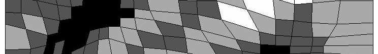
11 model that matches the history. This is a result of the fact that full flow simulations are performed on the coarse model, It is a generic method and serves as an alternative approach to reservoir characterization. 2.1 Example To make a better understanding of the proposed approach by Tureyen and Caers (2002), an example will be briefly reviewed in this section. Figure-4 gives the reference permeability field along with its corresponding water cut curve and sample statistics regarding the generation of the reference field. This field represents a cross-section of a reservoir which is modelled with 50 grid blocks in the horizontal and 50 grid blocks in the vertical directions. The flow scheme takes place with an injector and a producer under fixed bottom hole pressures (5500psi for the injector and 4500psi for the producer). The production history is for 500 days. In this example the perturbation was accomplished through a single parameter gradual deformation method, Roggero and Hu (1998). Sequential Gaussian Simulation (Deutsch and Journel (1998)) was used to generate the reference permeability field and to generate realizations for the gradual deformation method. The upgridding technique was adopted from Durlofsky and Milliken (1997), a single phase upscaling technique (Tran (1995)) was used to upscale the models once they were upgrided and finally a two-phase finite difference simulation model was chosen as the full flow simulation model (FSM ). 10
12 The results of the example given by Tureyen and Caers (2002) are given in Figure-5. Figure-5a gives the flow responses of 20 realizations conditioned only to hard data (no history matching has been performed). The relatively wide scatter of the flow responses are obvious. Most importantly it should be noted that the flow responses for these 20 realizations were obtained by evaluating the full flow simulation model on the fine scale. Figure-5b illustrates the results in which the proposed algorithm has been applied to 20 realizations. It is clear in this case that all realizations match the history up to 500 days along with relatively accurate future predictions. Most importantly all full flow simulations were conducted on coarse models. As mentioned earlier the immediate end result of the proposed algorithm are models that are coarse, non-uniformly gridded and match the history. Hence the realizations in Figure-5b are coarse, non-uniformly gridded and match the history. 3 Problems With Parallel Modelling Although the parallel modelling proposed by Tureyen and Caers (2002) offers an effective method to reservoir characterization, there are some limitations to this approach. These can be summarized as follows: As mentioned in Section-2, during the entire characterization process there are two models that are kept in parallel; the fine scale and the coarse scale. Geostatistics is performed on the fine scale whereas full flow simulations are performed on the coarse scale. Because of this reason it is guaranteed that the coarse model will match the history (as shown in the example given in Section-2.1). However at the end 11
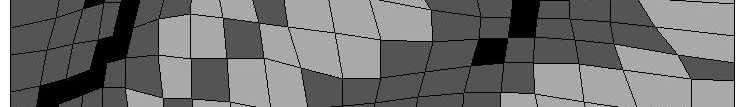
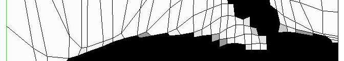
13 of the process the corresponding fine scale model, where all hard data and seismic data are honored, might not match the history. The level of coarsening can play an important role during the process. Tureyen and Caers (2002) upscaled from a fine scale model to a coarse scale model. However the decision regarding the level of coarsening is fixed prior to characterization. Taking into account that the fine scale reservoir is perturbed and may significantly change during the history matching phase, the level of coarsening may not be known prior to history matching. 3.1 Example Case To demonstrate the importance of the upscaling level, we present an example similar to that given in Section-2.1. Most of the outline of the example is similar to that given in the previous section, hence only the results will be discussed. In this example the fine grid is upscaled to non-realistic grid dimensions of 5 5 on the coarse scale. Figure-6a illustrates this case. It is clear that the permeability field (Figure-6a) is not representative of the fine scale geology. However when we consider Figure-6b (which shows the flow responses of 5 realizations with grid dimensions of 5 5 at the end of the history matching process) it is clear that models with such grid dimensions can match the history equally well as the ones shown in the example given in Section-2.1. Recall that the history matching procedure reduces the mismatch between field and simulated data on the coarse grid, hence it is possible 12
14 that the reservoir can be perturbed till history match on the coarse scale, regardless of the upscaling errors. As a result, when performing flow simulation on Figure-7a, a serious mismatch between field and simulated data is observed. This might have the following consequences: The fine scale models are the closest representation of the actual geological variability. Despite history matching the coarse scale model, the fine scale model still show considerable variability in the flow response, Figure-(7b), hence geological variability has not been drastically reduced. In other words, a poor history matching procedure does not necessarily reduce geological uncertainty, despite the fact that a history match is obtained. Fine scale models are often used for well placement optimization problems (Guyaguler (2001)) hence a history match on the fine scale may be desirable. 4 Proposed Solution: Gridding Optimization The essential shortcoming in the method of Tureyen and Caers (2002) lies in the fact that upscaling errors are not accounted for. The idea of perturbing the fine scale geological model based on the flow results of the coarse model would only make sense if the upscaling errors are minimal. Otherwise, if upscaling errors are not negligible, the fine scale models will not match the history. In this paper we propose a method that aims at improving the 13
15 correction between the fine scale and the coarse scale response by reducing the upscaling errors, while history matching. First, we proceed by defining additional notation similar to the ones given in Section-2. FSM : a flow simulator that is a fast approximation of FSM ; RP * : the flow response when FSM is performed on z ; Figure-8 illustrates the proposed method schematically. The work flow starts by constructing a fine scale geostatistical model. However, instead of directly proceeding with the upscaling and upgridding phase (proposed in Section-2) a gridding optimization is performed to ensure that the upscaling errors between the flow responses of the fine scale and the coarse scale models are minimized. In other words we can define an ɛ parameter such that; ɛ = F SM(z up (r)) F SM(z (r)) (4) or ɛ = F SM(S θ (z (r))) F SM(z (r)) (5) at the end of the gridding optimization the ɛ parameter is minimized. It is clear that in all cases we will not have access to the information FSM (z (r)) (which is the flow response of the fine scale model when the full flow simulation is performed), if we had, there would not be a necessity for upscaling in the first place. Hence the challenge is to reduce the upscaling errors ɛ without knowing FSM (z (r)). 14
16 To achieve this we introduce a fast approximation to the flow model, FSM. The proposed approach for the optimization is such that, instead of optimizing on the error ɛ directly, we introduce an approximate error ɛ, for any given r, given by: ɛ (θ, S) = F SM (S θ (z (r))) F SM (z (r)) (6) The error ɛ is evidently a function of the upscaling method S and its parameters θ. ɛ can be minimized by finding an optimal set S and θ. Minimizing ɛ therefore consists of reducing the mismatch between the production data F SM (z (r)) evaluated on the fine scale using the approximated flow simulator F SM and the production data. F SM (z up (r)), is the same flow evaluated on the coarse scale. Note two important points: 1. To minimize ɛ the actual flow response D is not used, neither does one have to use the same boundary conditions as in the reservoir. 2. In order to find an optimal θ and S we need to evaluate F SM one single time on the fine scale realization z (r) to obtain a reference fast flow response. Multiple flow simulations are required on z up (r) to find the optimal θ and S. Hence the CPU time spent in solving the optimization problem of finding S and θ will be small compared to running FSM on z up (r). The assumption made is the following: Once ɛ has been made small enough ɛ has also been reduced, although probably not by the same amount as ɛ. In other words the objective function defined on F SM namely ɛ is monotonically varying with the objective function defined on FSM namely ɛ. 15
17 The ranking of models provided by F SM is the same as the ranking provided by F SM : the errors ɛ and ɛ need not be the same in absolute magnitude. A similar approach related to the problem of uncertainty quantification is taken in Ballin and Journel (1993). As a result the overall proposed method consists of two optimization levels: the outer level concerns history matching, the inner level consists of a grid optimization. 5 Example In this section we present a synthetic case study for the approach presented in the previous section. A different upscaling/upgridding approach will be used in this case. In their example Tureyen and Caers (2002) used the method of Durlofsky and Milliken (1997), which was a flow based gridding technique. In this example we use a static based upgridding method described in the following subsection DDEGA 3DDEGA (see Garcia (1990)) is an effective and efficient gridding algorithm, where the objective is to automatically generate coarse grids that fit the geological heterogeneities. The output of the algorithm are quadrilateral or hexahedric grids that can be a direct input into commercial numerical reservoir simulators through a corner-point geometry description of grid blocks. The main idea behind the 3DDEGA algorithm is to generate coarse grid blocks that are as homogeneous as possible in terms of an input variable 16
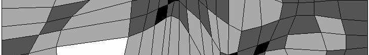
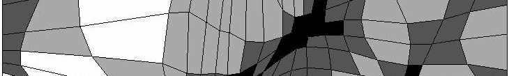
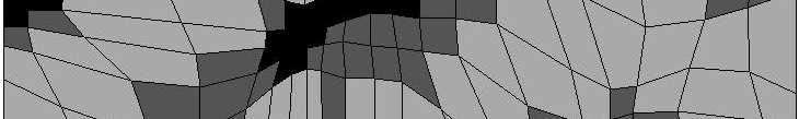
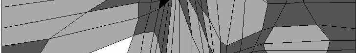
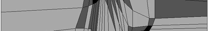
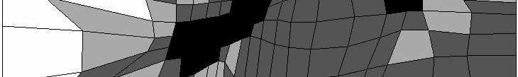
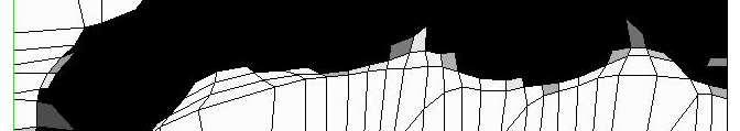
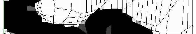
18 (permeability map, porosity map, facies map, etc.) that is obtained from an underlying fine scale model. The grid edges are assigned elastic properties that allow them to expand or shrink to make the coarse blocks homogeneous. In order to accomplish this, the algorithm goes through three major steps, which are: Determine the grid block heterogeneities, which is also accomplished in three steps; Retrieve the fine scale grid cells within a coarse grid block, Compute the same statistics of the fine grid cells within each coarse grid block Determine a heterogeneity index for the coarse block from the internal block statistics. Update the grid-edge elasticity coefficients (that are a function of the heterogeneity index), Compute the new grid-vertex locations that minimize the heterogeneity which is defined by the heterogeneity index. Figure-9 illustrates how the 3DDEGA algorithm responds to a unique example of fine scale heterogeneity. The fine scale contains a box with high permeability. In the coarse scale the algorithm adjusts itself to refine around the region of high permeability and coarsen through out in the other regions. It is also important to note how the grid blocks are deviated from orthogonality to better preserve the high permeability region as it is on the coarse grid. 17
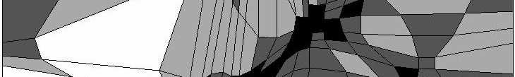
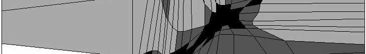
19 To capture heterogeneity quantitatively a block coefficient of heterogeneity (heterogeneity index) is defined as follows: β B = 1 Nd =1 i=1 (1 + µ i ) 1 ( N d =1 i=1 1 + µ i ( σ i B σ i max ) ωi ) ( VB 1 V norm ) ωv (7) where, i = 1,,N d, refers to the input variables (fine scale input variables that are within the limits of the coarse grid block boundaries), σmax i is the maximum of all internal block variances (or equivalent expression for a categorical variable) for data variable i, µ i and ω i (both positive) are a weight and a power assigned to data variable i, V B is block B s volume, ω V is a power assigned to the block volume term, V norm is such that V ω V norm=max(v ω V min,v ω V max) However if there is only a single variable then Equation-7 reduces to: ( ) σ i ωi ( ) ωv β B = B VB (8) σmax i V norm To obtain a better understanding the procedure will be explained through Figure-10. For a given coarse grid block (for example grid block B1 in Figure- 10) the inter block variance (σb)is 1 calculated (variance of the fine scale input variable within the limits of coarse grid block B1). Once this is obtained the 18
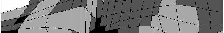
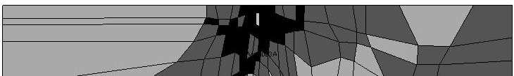
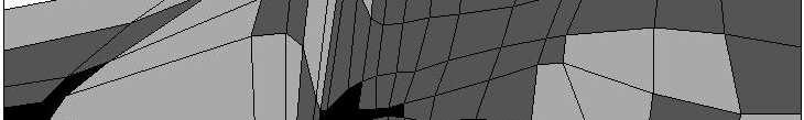
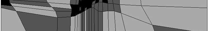
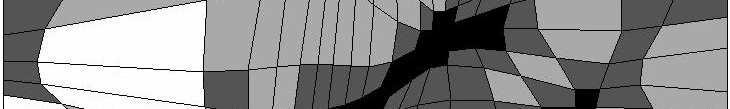
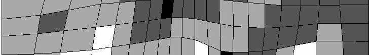
20 block coefficient of heterogeneity can be determined for both blocks B1 and B2. The elasticity of the edge that neighbors blocks B1 and B2 can now be determined from the block coefficients of heterogeneity of both blocks (the elasticity is a function of the average block coefficients of heterogeneity). Given the elasticity, the optimal location of the grid vertices can be determined such that the block coefficient of heterogeneity will be minimized. The second term in Equation-8 is used for controlling the coarse grid volumes. If a number of very small and very large grid blocks exist neighboring each other, this term will be large. This term is therefore introduced to control the quality of the grid by controlling the relative volumes of coarse grid blocks. ω i and ω V are weights for emphasizing heterogeneity versus emphasizing grid conformity. Some more insight into the importance of these parameters are provided. Figure-11 illustrates the fine scale reference image and various upscaled coarse models (obtained by evaluating the 3DDEGA algorithm on the reference fine scale image) through which the sensitivities are given. The top row of Figure-11 represent variation in the ω i parameter, for fixed ω V, and the bottom row represent variation in the ω V parameter, for fixed ω i. The ω i parameter emphasizes on geological heterogeneity. As it is clearly seen from the top row Figure-11 that if ω i =0.0 then no emphasis is given to geological heterogeneity hence a uniform grid is obtained. As we increase the ω i parameter more emphasis is given to the regions of higher geological variability hence the resulting gridding tries to refine these regions as much as possible. However for large ω i (Figure-11, ω i =1.0 and ω V =0.0) certain regions are over-refined leading to small grid blocks neighboring large grid 19
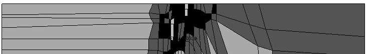
21 blocks. This might not be desirable in some cases especially for the stability of flow calculations. Hence to achieve a control on the block volumes the ω V parameter is introduced. The bottom row of Figure-11 studies the effect of the ω V parameter that has a global control on the grid block volumes. When a negative value of this parameter is used (such as ω V =-0.5) the algorithm allows very large grid blocks to neighbor very small grid blocks (Figure-11, ω i =1.0 and ω V =-0.5). With increasing ω V, more restriction is put on the coarse grid block volumes, hence for a high ω V (such as ω V =2.0 in the bottom row of Figure-11) the grid blocks become almost uniform. 5.2 Synthetic Example In this section we present the enhanced parallel modelling approach with a synthetic example. Before giving details regarding the example, we present the work-flow specific to this example, see Figure-12. The work-flow starts with constructing the fine scale model. Streamline simulation is performed on the fine scale where the pseudo water cut curve is obtained. Using the 3DDEGA algorithm, the fine scale model is upgridded to a coarse model. Streamline simulation is performed on the coarse scale model, and the mismatch between the pseudo water cut curves of the fine scale and the coarse scale models are then calculated. Streamline simulation is performed multiple times on the coarse scale model until the 3DDEGA gridding parameters are optimized and the mismatch is minimized. In addition to ω i and ω V a third parameter is also introduced in the gridding optimization process, namely the number of grid blocks in the x direction (n c x)for the coarse scale. 20
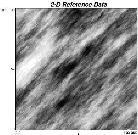
22 The total number of grid blocks on the coarse scale are fixed (n c x n c y remain fixed). Hence once n c x is varied a value for n c y can be determined. Once the gridding optimization is completed, then full flow simulation is performed on the coarse model and the mismatch is calculated between the calculated data and the observed field data. This procedure is repeated until a history match is obtained. As mentioned earlier the proposed algorithm is generic. In the following example, the perturbation method (single parameter probability perturbation method) was adopted from Caers (2003). Instead of a variogram based geostatistical technique, in this case we use a training image based algorithm for generating realizations, where we model facies instead of continuous permeability values. The upgridding is performed by the 3DDEGA algorithm while the upscaling is achieved by arithmetic averaging of individual values. The full simulation model and the approximate fast simulation models are once again taken as a finite difference simulator and a streamline simulator respectively. The reference permeability field and its corresponding water cut curve is given in Figure-13. A constant permeability value of md is assigned to the sand facies and 100 md is assigned to the mud facies. The given reference model is a quarter-five spot pattern with grid blocks in the x and y directions. Each grid block is of 20ft 20ft with a total of 2000 ft in the x and y directions. The depth is taken as 200 ft. The production history is taken to be 500 days and the permeability values at the well locations are treated as conditioning hard data. Figure-14 illustrates the results for 30 realizations not constrained to 21
23 water-cut data. As expected the flow responses of the fine scale models conditioned only to hard data give a relatively wide scatter. As a result of the proposed algorithm, optimally gridded coarse scale models match the history well, and provide accurate future predictions for the same well configuration. If grid optimization had not been performed during the characterization process, then the results given in Figure-15 would be obtained. Even though a history match is obtained on the coarse scale, the fine scale responses still present a wide scatter. When performing grid optimization (see Figure-16), the upscaling errors are minimized and the fine scale models also become representative of the history. 6 Conclusions An alternative approach to reservoir characterization is presented in this paper. The following conclusions are obtained: Introducing upscaling/upgridding within the history matching process is an effective technique for history matching non-uniformly gridded models directly. However caution needs to be taken such that the resulting fine scale models need not match history. Introducing a second level of optimization for optimizing the gridding during the upscaling phase results in a better understanding of the upgridding parameters, furthermore improvements are observed on the fine scale matches where the full flow simulations are performed only on the coarse scale models. 22
24 With the parallel modelling approach, all data are integrated jointly at their relative scales. It is important to note that optimizing gridding parameters while history matching is different from choosing for an optimal or adequate set of gridding/upscaling parameters prior to history matching. An optimal set of parameters for a particular fine scale realization is not necessarily optimal for another realization, even when both have similar geological heterogeneity. The gridding itself should therefore be a variable of the entire data integration process. 23
25 References Ballin, P.R., A. K. and Journel, A.G., Z. L. (1993). Quantifying the Impact of Geological Uncertainty on Reservoir Performance Forecasts, paper SPE presented at the 12 th SPE Symposium on Reservoir Simulation, New Orleans, Louisiana, 28 February - 3 March. Caers, J. (2001). The next frontier in petroleum geostatistics. Keynote address, presented at the Annual Meeting of the International Association for Mathematical Geology, Cancun, Mexico, 9-12 September. Caers, J. (2003). Geostatistical History Matching Under Training-Image Based Geological Model Constraints. SPE Journal, pp Deutsch, C. and Journel, A. (1998). GSLIB, Geostatistical Software Library and Users Guide. Oxford University Press. Durlofsky, L.J., J. R. and Milliken, W. (1997). A Non-Uniform Coarsening Approach for the Scale-Up of Displacement Processes in Heterogeneous Porous Media. Advances in Water Resources, pp Garcia, M.H., J. A. A. K. (1990). An Automatic Grid Generation and Adjustment Method for Modeling Reservoir Heterogeneities. 3 rd scrf annual report, Stanford Center for Reservoir Forecasting, Stanford University, California, USA. Guyaguler, B., H. R. (2001). Uncertainty Assesment of Well Placement Optimization, paper SPE presented at the Annual Technical Conference and Exhibition, New Orleans, Louisiana, 30 September - 2 October. 24
26 Landa, J.L., H. R. (1997). A Procedure to Integrate Well Test Data, Reservoir Performance History and 4-D Seismic Information into a Reservoir Description, paper SPE presented at the Annual Technical Conference and Exhibition, San Antonio Texas, 5-8 October. Mezghani, M. and Roggero, F. (2001). Combining Gradual Deformation and Upscaling Techniques for Direct Conditioning of Fine Scale Reservoir Models to Dynamic DATA, paper SPE presented at the Annual Technical Conference, New Orleans, Louisiana, USA, 30 September-3 October. Roggero, F. and Hu, L. (1998). Gradual deformation of continuous geostatistical models for history matching, presented at the Annual Technical Conference and Exhibition, New Orleans, Louisiana, September. Tran, T. (1995). Stochastic Simulation of Permeability Fields and Their Scale-up for Flow Modeling. Master s thesis, Stanford University. Tran T.T., Wen, X. and Behrens, R. (1999). Efficient Conditioning of 3D Fine Scale Reservoir Model To Multiphase Production Data Using Streamline- Based Coarse-Scale Inversion and Geostatistical Downscaling, paper SPE presented at the Annual Technical Conference, Houston, Texas, USA, 3-6October. Tureyen, O. and Caers, J. (2002). A Geostatistical Approach to History Matching Flow Data on Non-Uniform Grids, presented at the European Conference on Mathemathics of Oil Recovery, Freiberg, GERMANY, 3-6 September. 25
27 Wen, X.H., D. C. and Cullik, A. (1998). Integrating Pressure and Fractional Flow Data in Reservoir Modelling With Fast Streamline Inverse Methods, paper SPE presented at the Annual Technical Conference and Exhibition, New Orleans, Louisiana, 27 September - 30 September. 26
28 7 List of Figures Figure-1 Hierarchical approach to reservoir characterization. Figure-2 A traditional approach to history matching. Figure-3 Basic Parallel Modelling for Reservoir Characterization. Figure-4 a - Reference field, b - Corresponding water cut curve, c - Sample statistics regarding the generation of the reference field. Figure-5 a - Flow responses of 20 realizations (fine scale) conditioned only to hard data, b - Flow responses of 20 realizations (coarse scale) when the proposed algorithm is applied. Figure-6 a - History matched realization with grid dimensions of 5 5, b - Flow responses of 5 realizations with grid dimensions of 5 5. Figure-7 a - Fine scale realization corresponding to the history matched 5 5 realization given in Figure-6a, b - Flow responses of 5 fine scale realizations. Figure-8 Schematical diagram of the parallel approach with the gridding optimization. Figure-9 Typical Gridding Provided by 3DDEGA. Figure-10 Schematics illustrating various aspects of the block coefficient of heterogeneity. Figure-11 Sensitivity results of the ω i and ω V parameters on gridding. 27
29 Figure-12 The parallel modelling approach specific to the synthetic example. Figure-13 The reference permeability field and its corresponding flow response. Figure-14 Flow responses of 30 non-history matched realizations and 30 history matched realizations. Figure-15 Comparison of fine scale and coarse scale flow responses in the case where grid optimization has not been performed. Figure-16 Comparison of fine scale and coarse scale flow responses in the case where grid optimization has been performed. 28


30 8 Figures Figure 1: Hierarchical approach to reservoir characterization 29


31 Figure 2: A traditional approach to history matching 30
32 Figure 3: Basic Parallel Modelling for Reservoir Characterization 31


33 Figure 4: a - Reference field, b - Corresponding water cut curve, c - Sample statistics regarding the generation of the reference field. 32
 when the proposed algorithm is applied. 33")
34 Figure 5: a - Flow responses of 20 realizations (fine scale) conditioned only to hard data, b - Flow responses of 20 realizations (coarse scale) when the proposed algorithm is applied. 33
35 Figure 6: a - History matched realization with grid dimensions of 5 5, b - Flow responses of 5 realizations with grid dimensions of
36 Figure 7: a - Fine scale realization corresponding to the history matched 5 5 realization given in Figure-6a, b - Flow responses of 5 fine scale realizations. 35
37 Figure 8: Schematical diagram of the parallel approach with the gridding optimization. 36

38 Figure 9: Typical Gridding Provided by 3DDEGA 37

39 Figure 10: Schematics illustrating various aspects of the block coefficient of heterogeneity 38


40 Figure 11: Sensitivity results of the ω i and ω V 39 parameters on gridding.


41 Figure 12: The parallel modelling approach specific to the synthetic example. 40
42 Figure 13: The reference permeability field and its corresponding flow response. 41
43 Figure 14: Flow responses of 30 non-history matched realizations and 30 history matched realizations. 42
44 Figure 15: Comparison of fine scale and coarse scale flow responses in the case where grid optimization has not been performed. 43
45 Figure 16: Comparison of fine scale and coarse scale flow responses in the case where grid optimization has been performed. 44
Using 3D-DEGA. Omer Inanc Tureyen and Jef Caers Department of Petroleum Engineering Stanford University
 Using 3D-DEGA Omer Inanc Tureyen and Jef Caers Department of Petroleum Engineering Stanford University 1 1 Introduction With the advance of CPU power, numerical reservoir models have become an essential
A PARALLEL MODELLING APPROACH TO RESERVOIR CHARACTERIZATION
 A PARALLEL MODELLING APPROACH TO RESERVOIR CHARACTERIZATION A DISSERTATION SUBMITTED TO THE DEPARTMENT OF PETROLEUM ENGINEERING AND THE COMMITTEE ON GRADUATE STUDIES OF STANFORD UNIVERSITY IN PARTIAL FULFILLMENT
B. Todd Hoffman and Jef Caers Stanford University, California, USA
 Sequential Simulation under local non-linear constraints: Application to history matching B. Todd Hoffman and Jef Caers Stanford University, California, USA Introduction Sequential simulation has emerged
A Geostatistical and Flow Simulation Study on a Real Training Image
 A Geostatistical and Flow Simulation Study on a Real Training Image Weishan Ren (wren@ualberta.ca) Department of Civil & Environmental Engineering, University of Alberta Abstract A 12 cm by 18 cm slab
Integration of Geostatistical Modeling with History Matching: Global and Regional Perturbation
 Integration of Geostatistical Modeling with History Matching: Global and Regional Perturbation Oliveira, Gonçalo Soares Soares, Amílcar Oliveira (CERENA/IST) Schiozer, Denis José (UNISIM/UNICAMP) Introduction
A009 HISTORY MATCHING WITH THE PROBABILITY PERTURBATION METHOD APPLICATION TO A NORTH SEA RESERVOIR
 1 A009 HISTORY MATCHING WITH THE PROBABILITY PERTURBATION METHOD APPLICATION TO A NORTH SEA RESERVOIR B. Todd HOFFMAN and Jef CAERS Stanford University, Petroleum Engineering, Stanford CA 94305-2220 USA
Variogram Inversion and Uncertainty Using Dynamic Data. Simultaneouos Inversion with Variogram Updating
 Variogram Inversion and Uncertainty Using Dynamic Data Z. A. Reza (zreza@ualberta.ca) and C. V. Deutsch (cdeutsch@civil.ualberta.ca) Department of Civil & Environmental Engineering, University of Alberta
RM03 Integrating Petro-elastic Seismic Inversion and Static Model Building
 RM03 Integrating Petro-elastic Seismic Inversion and Static Model Building P. Gelderblom* (Shell Global Solutions International BV) SUMMARY This presentation focuses on various aspects of how the results
High Resolution Geomodeling, Ranking and Flow Simulation at SAGD Pad Scale
 High Resolution Geomodeling, Ranking and Flow Simulation at SAGD Pad Scale Chad T. Neufeld, Clayton V. Deutsch, C. Palmgren and T. B. Boyle Increasing computer power and improved reservoir simulation software
Downscaling saturations for modeling 4D seismic data
 Downscaling saturations for modeling 4D seismic data Scarlet A. Castro and Jef Caers Stanford Center for Reservoir Forecasting May 2005 Abstract 4D seismic data is used to monitor the movement of fluids
History matching under training-image based geological model constraints
 History matching under training-image based geological model constraints JEF CAERS Stanford University, Department of Petroleum Engineering Stanford, CA 94305-2220 January 2, 2002 Corresponding author
Tensor Based Approaches for LVA Field Inference
 Tensor Based Approaches for LVA Field Inference Maksuda Lillah and Jeff Boisvert The importance of locally varying anisotropy (LVA) in model construction can be significant; however, it is often ignored
Adaptive spatial resampling as a Markov chain Monte Carlo method for uncertainty quantification in seismic reservoir characterization
 1 Adaptive spatial resampling as a Markov chain Monte Carlo method for uncertainty quantification in seismic reservoir characterization Cheolkyun Jeong, Tapan Mukerji, and Gregoire Mariethoz Department
Short Note: Some Implementation Aspects of Multiple-Point Simulation
 Short Note: Some Implementation Aspects of Multiple-Point Simulation Steven Lyster 1, Clayton V. Deutsch 1, and Julián M. Ortiz 2 1 Department of Civil & Environmental Engineering University of Alberta
Simulating Geological Structures Based on Training Images and Pattern Classifications
 Simulating Geological Structures Based on Training Images and Pattern Classifications P. Switzer, T. Zhang, A. Journel Department of Geological and Environmental Sciences Stanford University CA, 9435,
Joint quantification of uncertainty on spatial and non-spatial reservoir parameters
 Joint quantification of uncertainty on spatial and non-spatial reservoir parameters Comparison between the Method and Distance Kernel Method Céline Scheidt and Jef Caers Stanford Center for Reservoir Forecasting,
Geostatistical Reservoir Characterization of McMurray Formation by 2-D Modeling
 Geostatistical Reservoir Characterization of McMurray Formation by 2-D Modeling Weishan Ren, Oy Leuangthong and Clayton V. Deutsch Department of Civil & Environmental Engineering, University of Alberta
On internal consistency, conditioning and models of uncertainty
 On internal consistency, conditioning and models of uncertainty Jef Caers, Stanford University Abstract Recent research has been tending towards building models of uncertainty of the Earth, not just building
A workflow to account for uncertainty in well-log data in 3D geostatistical reservoir modeling
 A workflow to account for uncertainty in well-log data in 3D geostatistical reservoir Jose Akamine and Jef Caers May, 2007 Stanford Center for Reservoir Forecasting Abstract Traditionally well log data
Generic framework for taking geological models as input for reservoir simulation
 Generic framework for taking geological models as input for reservoir simulation Collaborators: SINTEF: Texas A&M: NTNU: Stanford Stein Krogstad, Knut-Andreas Lie, Vera L. Hauge Yalchin Efendiev and Akhil
TPG4160 Reservoir simulation, Building a reservoir model
 TPG4160 Reservoir simulation, Building a reservoir model Per Arne Slotte Week 8 2018 Overview Plan for the lectures The main goal for these lectures is to present the main concepts of reservoir models
Markov Bayes Simulation for Structural Uncertainty Estimation
 P - 200 Markov Bayes Simulation for Structural Uncertainty Estimation Samik Sil*, Sanjay Srinivasan and Mrinal K Sen. University of Texas at Austin, samiksil@gmail.com Summary Reservoir models are built
Fluid flow modelling with seismic cluster analysis
 Fluid flow modelling with seismic cluster analysis Fluid flow modelling with seismic cluster analysis Laurence R. Bentley, Xuri Huang 1 and Claude Laflamme 2 ABSTRACT Cluster analysis is used to construct
Programs for MDE Modeling and Conditional Distribution Calculation
 Programs for MDE Modeling and Conditional Distribution Calculation Sahyun Hong and Clayton V. Deutsch Improved numerical reservoir models are constructed when all available diverse data sources are accounted
Rotation and affinity invariance in multiple-point geostatistics
 Rotation and ainity invariance in multiple-point geostatistics Tuanfeng Zhang December, 2001 Abstract Multiple-point stochastic simulation of facies spatial distribution requires a training image depicting
CONDITIONAL SIMULATION OF TRUNCATED RANDOM FIELDS USING GRADIENT METHODS
 CONDITIONAL SIMULATION OF TRUNCATED RANDOM FIELDS USING GRADIENT METHODS Introduction Ning Liu and Dean S. Oliver University of Oklahoma, Norman, Oklahoma, USA; ning@ou.edu The problem of estimating the
INTEGRATION OF LOCAL-GLOBAL UPSCALING AND GRID ADAPTIVITY FOR SIMULATION OF SUBSURFACE FLOW IN HETEROGENEOUS FORMATIONS
 INTEGRATION OF LOCAL-GLOBAL UPSCALING AND GRID ADAPTIVITY FOR SIMULATION OF SUBSURFACE FLOW IN HETEROGENEOUS FORMATIONS M. GERRITSEN AND J. V. LAMBERS Abstract. We propose a methodology, called multi-level
Exploring Direct Sampling and Iterative Spatial Resampling in History Matching
 Exploring Direct Sampling and Iterative Spatial Resampling in History Matching Matz Haugen, Grergoire Mariethoz and Tapan Mukerji Department of Energy Resources Engineering Stanford University Abstract
Calibration of NFR models with interpreted well-test k.h data. Michel Garcia
 Calibration of NFR models with interpreted well-test k.h data Michel Garcia Calibration with interpreted well-test k.h data Intermediate step between Reservoir characterization Static model conditioned
Geostatistics on Stratigraphic Grid
 Geostatistics on Stratigraphic Grid Antoine Bertoncello 1, Jef Caers 1, Pierre Biver 2 and Guillaume Caumon 3. 1 ERE department / Stanford University, Stanford CA USA; 2 Total CSTJF, Pau France; 3 CRPG-CNRS
Automatic History Matching On The Norne Simulation Model
 Automatic History Matching On The Norne Simulation Model Eirik Morell - TPG4530 - Norwegian University of Science and Technology - 2008 Abstract This paper presents the result of an automatic history match
Modeling Uncertainty in the Earth Sciences Jef Caers Stanford University
 Modeling spatial continuity Modeling Uncertainty in the Earth Sciences Jef Caers Stanford University Motivation uncertain uncertain certain or uncertain uncertain Spatial Input parameters Spatial Stochastic
Technique to Integrate Production and Static Data in a Self-Consistent Way Jorge L. Landa, SPE, Chevron Petroleum Technology Co.
 SPE 71597 Technique to Integrate Production and Static Data in a Self-Consistent Way Jorge L. Landa, SPE, Chevron Petroleum Technology Co. Copyright 2001, Society of Petroleum Engineers Inc. This paper
Fast FILTERSIM Simulation with Score-based Distance Function
 Fast FILTERSIM Simulation with Score-based Distance Function Jianbing Wu (1), André G. Journel (1) and Tuanfeng Zhang (2) (1) Department of Energy Resources Engineering, Stanford, CA (2) Schlumberger Doll
Sampling informative/complex a priori probability distributions using Gibbs sampling assisted by sequential simulation
 Sampling informative/complex a priori probability distributions using Gibbs sampling assisted by sequential simulation Thomas Mejer Hansen, Klaus Mosegaard, and Knud Skou Cordua 1 1 Center for Energy Resources
Toward reservoir simulation on geological grid models
 1 Toward reservoir simulation on geological grid models JØRG E. AARNES and KNUT ANDREAS LIE SINTEF ICT, Dept. of Applied Mathematics, P.O. Box 124 Blindern, NO-0314 Oslo, Norway Abstract We present a reservoir
Modeling Multiple Rock Types with Distance Functions: Methodology and Software
 Modeling Multiple Rock Types with Distance Functions: Methodology and Software Daniel A. Silva and Clayton V. Deutsch The sub division of the deposit into estimation domains that are internally consistent
Conditioning a hybrid geostatistical model to wells and seismic data
 Conditioning a hybrid geostatistical model to wells and seismic data Antoine Bertoncello, Gregoire Mariethoz, Tao Sun and Jef Caers ABSTRACT Hybrid geostatistical models imitate a sequence of depositional
PTE 519 Lecture Note Finite Difference Approximation (Model)
") PTE 519 Lecture Note 3 3.0 Finite Difference Approximation (Model) In this section of the lecture material, the focus is to define the terminology and to summarize the basic facts. The basic idea of any
PTE 519 Lecture Note 3 3.0 Finite Difference Approximation (Model) In this section of the lecture material, the focus is to define the terminology and to summarize the basic facts. The basic idea of any
The SPE Foundation through member donations and a contribution from Offshore Europe
 Primary funding is provided by The SPE Foundation through member donations and a contribution from Offshore Europe The Society is grateful to those companies that allow their professionals to serve as
History Matching: Towards Geologically Reasonable Models
 Downloaded from orbit.dtu.dk on: Oct 13, 018 History Matching: Towards Geologically Reasonable Models Melnikova, Yulia; Cordua, Knud Skou; Mosegaard, Klaus Publication date: 01 Document Version Publisher's
Homogenization and numerical Upscaling. Unsaturated flow and two-phase flow
 Homogenization and numerical Upscaling Unsaturated flow and two-phase flow Insa Neuweiler Institute of Hydromechanics, University of Stuttgart Outline Block 1: Introduction and Repetition Homogenization
Application of MPS Simulation with Multiple Training Image (MultiTI-MPS) to the Red Dog Deposit
 to the Red Dog Deposit") Application of MPS Simulation with Multiple Training Image (MultiTI-MPS) to the Red Dog Deposit Daniel A. Silva and Clayton V. Deutsch A Multiple Point Statistics simulation based on the mixing of two
Application of MPS Simulation with Multiple Training Image (MultiTI-MPS) to the Red Dog Deposit Daniel A. Silva and Clayton V. Deutsch A Multiple Point Statistics simulation based on the mixing of two
We G Updating the Reservoir Model Using Engineeringconsistent
 We G102 09 Updating the Reservoir Model Using Engineeringconsistent 4D Seismic Inversion S. Tian* (Heriot-Watt University), C. MacBeth (Heriot-Watt University) & A. Shams (Heriot-Watt University) SUMMARY
Reservoir Modeling Combining Geostatistics with Markov Chain Monte Carlo Inversion
 Reservoir Modeling Combining Geostatistics with Markov Chain Monte Carlo Inversion Andrea Zunino, Katrine Lange, Yulia Melnikova, Thomas Mejer Hansen and Klaus Mosegaard 1 Introduction Reservoir modeling
Hierarchical modeling of multi-scale flow barriers in channelized reservoirs
 Hierarchical modeling of multi-scale flow barriers in channelized reservoirs Hongmei Li and Jef Caers Stanford Center for Reservoir Forecasting Stanford University Abstract Channelized reservoirs often
Developing a Smart Proxy for the SACROC Water-Flooding Numerical Reservoir Simulation Model
 SPE-185691-MS Developing a Smart Proxy for the SACROC Water-Flooding Numerical Reservoir Simulation Model Faisal Alenezi and Shahab Mohaghegh, West Virginia University Copyright 2017, Society of Petroleum
Closing the Loop via Scenario Modeling in a Time-Lapse Study of an EOR Target in Oman
 Closing the Loop via Scenario Modeling in a Time-Lapse Study of an EOR Target in Oman Tania Mukherjee *(University of Houston), Kurang Mehta, Jorge Lopez (Shell International Exploration and Production
Multiple Point Statistics with Multiple Training Images
 Multiple Point Statistics with Multiple Training Images Daniel A. Silva and Clayton V. Deutsch Abstract Characterization of complex geological features and patterns has been one of the main tasks of geostatistics.
P257 Transform-domain Sparsity Regularization in Reconstruction of Channelized Facies
 P257 Transform-domain Sparsity Regularization in Reconstruction of Channelized Facies. azemi* (University of Alberta) & H.R. Siahkoohi (University of Tehran) SUMMARY Petrophysical reservoir properties,
Relative Permeability Upscaling for Heterogeneous Reservoir Models
 Relative Permeability Upscaling for Heterogeneous Reservoir Models Mohamed Ali Gomaa Fouda Submitted for the degree of Doctor of Philosophy Heriot-Watt University School of Energy, Geoscience, Infrastructure
M odel Selection by Functional Decomposition of M ulti-proxy Flow Responses
 M odel Selection by Functional Decomposition of M ulti-proxy Flow Responses Report Prepared for SCRF Affiliates Meeting, Stanford University 1 Ognjen Grujic and Jef Caers A bstract Time constraints play
2010 SEG SEG Denver 2010 Annual Meeting
 Localized anisotropic tomography with checkshot : Gulf of Mexico case study Andrey Bakulin*, Yangjun (Kevin) Liu, Olga Zdraveva, WesternGeco/Schlumberger Summary Borehole information must be used to build
Appropriate algorithm method for Petrophysical properties to construct 3D modeling for Mishrif formation in Amara oil field Jawad K.
 Appropriate algorithm method for Petrophysical properties to construct 3D modeling for Mishrif formation in Amara oil field Jawad K. Radhy AlBahadily Department of geology, college of science, Baghdad
A Geomodeling workflow used to model a complex carbonate reservoir with limited well control : modeling facies zones like fluid zones.
 A Geomodeling workflow used to model a complex carbonate reservoir with limited well control : modeling facies zones like fluid zones. Thomas Jerome (RPS), Ke Lovan (WesternZagros) and Suzanne Gentile
SPE Copyright 2002, Society of Petroleum Engineers Inc.
 SPE 77958 Reservoir Modelling With Neural Networks And Geostatistics: A Case Study From The Lower Tertiary Of The Shengli Oilfield, East China L. Wang, S. Tyson, Geo Visual Systems Australia Pty Ltd, X.
Using Blast Data to infer Training Images for MPS Simulation of Continuous Variables
 Paper 34, CCG Annual Report 14, 212 ( 212) Using Blast Data to infer Training Images for MPS Simulation of Continuous Variables Hai T. Nguyen and Jeff B. Boisvert Multiple-point simulation (MPS) methods
GAS PRODUCTION ANALYSIS:
 New Mexico Tech THINKING FOR A NEW MILLENNIUM TIGHT-GAS GAS PRODUCTION ANALYSIS: User Guide for a Type-Curve Matching Spreadsheet Program (TIGPA 2000.1) Her-Yuan Chen Assistant Professor Department of
OPTIMIZATION FOR AUTOMATIC HISTORY MATCHING
 INTERNATIONAL JOURNAL OF NUMERICAL ANALYSIS AND MODELING Volume 2, Supp, Pages 131 137 c 2005 Institute for Scientific Computing and Information OPTIMIZATION FOR AUTOMATIC HISTORY MATCHING Abstract. SHUGUANG
Hierarchical Trend Models Based on Architectural Elements
 Hierarchical Trend Models Based on Architectural Elements Michael J. Pyrcz (mpyrcz@ualberta.ca) and Clayton V. Deutsch (cdeutsch@ualberta.ca) Department of Civil & Environmental Engineering University
History Matching of Structurally Complex Reservoirs Using a Distance-based Model Parameterization
 History Matching of Structurally Complex Reservoirs Using a Distance-based Model Parameterization Satomi Suzuki, Guillaume Caumon, Jef Caers S. Suzuki, J. Caers Department of Energy Resources Engineering,
B002 DeliveryMassager - Propagating Seismic Inversion Information into Reservoir Flow Models
 B2 DeliveryMassager - Propagating Seismic Inversion Information into Reservoir Flow Models J. Gunning* (CSIRO Petroleum) & M.E. Glinsky (BHP Billiton Petroleum) SUMMARY We present a new open-source program
PARAMETRIC STUDY WITH GEOFRAC: A THREE-DIMENSIONAL STOCHASTIC FRACTURE FLOW MODEL. Alessandra Vecchiarelli, Rita Sousa, Herbert H.
 PROCEEDINGS, Thirty-Eighth Workshop on Geothermal Reservoir Engineering Stanford University, Stanford, California, February 3, 23 SGP-TR98 PARAMETRIC STUDY WITH GEOFRAC: A THREE-DIMENSIONAL STOCHASTIC
A012 A REAL PARAMETER GENETIC ALGORITHM FOR CLUSTER IDENTIFICATION IN HISTORY MATCHING
 1 A012 A REAL PARAMETER GENETIC ALGORITHM FOR CLUSTER IDENTIFICATION IN HISTORY MATCHING Jonathan N Carter and Pedro J Ballester Dept Earth Science and Engineering, Imperial College, London Abstract Non-linear
Joint Entity Resolution
 Joint Entity Resolution Steven Euijong Whang, Hector Garcia-Molina Computer Science Department, Stanford University 353 Serra Mall, Stanford, CA 94305, USA {swhang, hector}@cs.stanford.edu No Institute
Scale-up of well performance for reservoir flow simulation
 Scale-up of well performance for reservoir flow simulation A.H. Muggeridge 1, M. Cuypers 2, C. Bacquet 2 and J.W. Barker 3 1 Department of Earth Science and Engineering, Imperial College, London SW7 2AZ,
Selected Implementation Issues with Sequential Gaussian Simulation
 Selected Implementation Issues with Sequential Gaussian Simulation Abstract Stefan Zanon (szanon@ualberta.ca) and Oy Leuangthong (oy@ualberta.ca) Department of Civil & Environmental Engineering University
Challenge Problem 5 - The Solution Dynamic Characteristics of a Truss Structure
 Challenge Problem 5 - The Solution Dynamic Characteristics of a Truss Structure In the final year of his engineering degree course a student was introduced to finite element analysis and conducted an assessment
Adaptive Waveform Inversion: Theory Mike Warner*, Imperial College London, and Lluís Guasch, Sub Salt Solutions Limited
 Adaptive Waveform Inversion: Theory Mike Warner*, Imperial College London, and Lluís Guasch, Sub Salt Solutions Limited Summary We present a new method for performing full-waveform inversion that appears
D025 Geostatistical Stochastic Elastic Iinversion - An Efficient Method for Integrating Seismic and Well Data Constraints
 D025 Geostatistical Stochastic Elastic Iinversion - An Efficient Method for Integrating Seismic and Well Data Constraints P.R. Williamson (Total E&P USA Inc.), A.J. Cherrett* (Total SA) & R. Bornard (CGGVeritas)
CIPC Louis Mattar. Fekete Associates Inc. Analytical Solutions in Well Testing
 CIPC 2003 Louis Mattar Fekete Associates Inc Analytical Solutions in Well Testing Well Test Equation 2 P 2 P 1 P + = x 2 y 2 α t Solutions Analytical Semi-Analytical Numerical - Finite Difference Numerical
SIMPAT: Stochastic Simulation with Patterns
 SIMPAT: Stochastic Simulation with Patterns G. Burc Arpat Stanford Center for Reservoir Forecasting Stanford University, Stanford, CA 94305-2220 April 26, 2004 Abstract Flow in a reservoir is mostly controlled
Multiple-point geostatistics: a quantitative vehicle for integrating geologic analogs into multiple reservoir models
 Multiple-point geostatistics: a quantitative vehicle for integrating geologic analogs into multiple reservoir models JEF CAERS AND TUANFENG ZHANG Stanford University, Stanford Center for Reservoir Forecasting
Accelerating Double Precision FEM Simulations with GPUs
 Accelerating Double Precision FEM Simulations with GPUs Dominik Göddeke 1 3 Robert Strzodka 2 Stefan Turek 1 dominik.goeddeke@math.uni-dortmund.de 1 Mathematics III: Applied Mathematics and Numerics, University
Prediction under Uncertainty in Reservoir Modeling
 1 Prediction under Uncertainty in Reservoir Modeling Mike Christie 1, Sam Subbey 1, Malcolm Sambridge 1 Institute of Petroleum Engineering, Heriot-Watt University, Edinburgh, EH14 4AS, UK Institute of
Improvement of Realizations through Ranking for Oil Reservoir Performance Prediction
 Improvement of Realizations through Ranking for Oil Reservoir Performance Prediction Stefan Zanon, Fuenglarb Zabel, and Clayton V. Deutsch Centre for Computational Geostatistics (CCG) Department of Civil
Ensemble Kalman Filter Predictor Bias Correction Method for Non-Gaussian Geological Facies Detection
 Proceedings of the 01 IFAC Worshop on Automatic Control in Offshore Oil and Gas Production, Norwegian University of Science and Technology, Trondheim, Norway, May 31 - June 1, 01 ThC. Ensemble Kalman Filter
Estimation of a Piecewise Constant Function Using Reparameterized Level-Set Functions
 Estimation of a iecewise Constant Function Using Reparameterized Level-Set Functions nga Berre 1,2, Martha Lien 2,1, and Trond Mannseth 2,1 1 Department of Mathematics, University of Bergen, Johs. Brunsgt.
Multi-Objective Stochastic Optimization by Co-Direct Sequential Simulation for History Matching of Oil Reservoirs
 Multi-Objective Stochastic Optimization by Co-Direct Sequential Simulation for History Matching of Oil Reservoirs João Daniel Trigo Pereira Carneiro under the supervision of Amílcar de Oliveira Soares
CONDITIONING FACIES SIMULATIONS WITH CONNECTIVITY DATA
 CONDITIONING FACIES SIMULATIONS WITH CONNECTIVITY DATA PHILIPPE RENARD (1) and JEF CAERS (2) (1) Centre for Hydrogeology, University of Neuchâtel, Switzerland (2) Stanford Center for Reservoir Forecasting,
THE preceding chapters were all devoted to the analysis of images and signals which
 Chapter 5 Segmentation of Color, Texture, and Orientation Images THE preceding chapters were all devoted to the analysis of images and signals which take values in IR. It is often necessary, however, to
Uncertainty Quantification Using Distances and Kernel Methods Application to a Deepwater Turbidite Reservoir
 Uncertainty Quantification Using Distances and Kernel Methods Application to a Deepwater Turbidite Reservoir Céline Scheidt and Jef Caers Stanford Center for Reservoir Forecasting, Stanford University
The Proportional Effect: What it is and how do we model it?
 The Proportional Effect: What it is and how do we model it? John Manchuk Centre for Computational Geostatistics Department of Civil & Environmental Engineering University of Alberta One of the outstanding
CFD Project Workflow Guide
 CFD Project Workflow Guide Contents Select a problem with known results for proof-of-concept testing... 1 Set up and run a coarse test case... 2 Select and calibrate numerical methods... 3 Minimize & quantify
A Data estimation Based Approach for Quasi continuous Reservoir Monitoring using Sparse Surface Seismic Data Introduction Figure 1
 A Data estimation Based Approach for Quasi continuous Reservoir Monitoring using Sparse Surface Seismic Data Adeyemi Arogunmati* and Jerry M. Harris, Stanford University, California, USA Introduction One
3D Inversion of Time-Domain Electromagnetic Data for Ground Water Aquifers
 3D Inversion of Time-Domain Electromagnetic Data for Ground Water Aquifers Elliot M. Holtham 1, Mike McMillan 1 and Eldad Haber 2 (1) Computational Geosciences Inc. (2) University of British Columbia Summary
We B3 12 Full Waveform Inversion for Reservoir Characterization - A Synthetic Study
 We B3 12 Full Waveform Inversion for Reservoir Characterization - A Synthetic Study E. Zabihi Naeini* (Ikon Science), N. Kamath (Colorado School of Mines), I. Tsvankin (Colorado School of Mines), T. Alkhalifah
G009 Scale and Direction-guided Interpolation of Aliased Seismic Data in the Curvelet Domain
 G009 Scale and Direction-guided Interpolation of Aliased Seismic Data in the Curvelet Domain M. Naghizadeh* (University of Alberta) & M. Sacchi (University of Alberta) SUMMARY We propose a robust interpolation
DETAILED ASSESSMENT OF MULTILEVEL OPTIMIZATION FOR FIELD DEVELOPMENT
 DETAILED ASSESSMENT OF MULTILEVEL OPTIMIZATION FOR FIELD DEVELOPMENT A THESIS SUBMITTED TO THE PROGRAM IN ENERGY RESOURCES ENGINEERING OF STANFORD UNIVERSITY IN PARTIAL FULFILLMENT OF THE REQUIREMENTS
Ultrasonic Multi-Skip Tomography for Pipe Inspection
 18 th World Conference on Non destructive Testing, 16-2 April 212, Durban, South Africa Ultrasonic Multi-Skip Tomography for Pipe Inspection Arno VOLKER 1, Rik VOS 1 Alan HUNTER 1 1 TNO, Stieltjesweg 1,
Effects of multi-scale velocity heterogeneities on wave-equation migration Yong Ma and Paul Sava, Center for Wave Phenomena, Colorado School of Mines
 Effects of multi-scale velocity heterogeneities on wave-equation migration Yong Ma and Paul Sava, Center for Wave Phenomena, Colorado School of Mines SUMMARY Velocity models used for wavefield-based seismic
Geostatistics 2D GMS 7.0 TUTORIALS. 1 Introduction. 1.1 Contents
 GMS 7.0 TUTORIALS 1 Introduction Two-dimensional geostatistics (interpolation) can be performed in GMS using the 2D Scatter Point module. The module is used to interpolate from sets of 2D scatter points
SPE Distinguished Lecturer Program
 SPE Distinguished Lecturer Program Primary funding is provided by The SPE Foundation through member donations and a contribution from Offshore Europe The Society is grateful to those companies that allow
Upscaling of Geocellular Models for Reservoir Flow Simulation: A Review of Recent Progress
 Upscaling of Geocellular Models for Reservoir Flow Simulation: A Review of Recent Progress Louis J. Durlofsky Department of Petroleum Engineering, Stanford University, Stanford, CA ChevronTexaco Exploration
SMART WELL MODELLING. Design, Scenarios and Optimisation
 Page 1 Introduction Smart or complex wells are in increasing use by operators as reservoir environments become more challenging. The wells include a number of smart devices installed to achieve a variety
Short Note. Non-stationary PEFs and large gaps. William Curry 1 INTRODUCTION
 Stanford Exploration Project, Report 120, May 3, 2005, pages 247 257 Short Note Non-stationary PEFs and large gaps William Curry 1 INTRODUCTION Prediction-error filters (PEFs) may be used to interpolate
PS wave AVO aspects on processing, inversion, and interpretation
 PS wave AVO aspects on processing, inversion, and interpretation Yong Xu, Paradigm Geophysical Canada Summary Using PS wave AVO inversion, density contrasts can be obtained from converted wave data. The
2D Geostatistical Modeling and Volume Estimation of an Important Part of Western Onland Oil Field, India.
 and Volume Estimation of an Important Part of Western Onland Oil Field, India Summary Satyajit Mondal*, Liendon Ziete, and B.S.Bisht ( GEOPIC, ONGC) M.A.Z.Mallik (E&D, Directorate, ONGC) Email: mondal_satyajit@ongc.co.in
SPE Intelligent Time Successive Production Modeling Y. Khazaeni, SPE, S. D. Mohaghegh, SPE, West Virginia University
 SPE 132643 Intelligent Time Successive Production Modeling Y. Khazaeni, SPE, S. D. Mohaghegh, SPE, West Virginia University Copyright 2010, Society of Petroleum Engineers This paper was prepared for presentation
Experiments with Edge Detection using One-dimensional Surface Fitting
 Experiments with Edge Detection using One-dimensional Surface Fitting Gabor Terei, Jorge Luis Nunes e Silva Brito The Ohio State University, Department of Geodetic Science and Surveying 1958 Neil Avenue,