CIEEM, Irish Section Conference & AGM Tommy Furey, Marine Institute, Ireland. & Koen Verbruggen, Director, GSI
|
|
|
- Donald Cobb
- 5 years ago
- Views:
Transcription


")
1 INFOMAR application of integrated mapping approaches and technologies to deliver baseline seabed and habitat mapping for Ireland CIEEM, Irish Section Conference & AGM 2016 Tommy Furey, Marine Institute, Ireland INFOMAR Joint Programme Manager (with GSI) & Koen Verbruggen, Director, GSI

2
3 Programme Overview PROGRAMME 1 What BASELINE Data acquisition, interpretation, management How Vessels, aircraft, equipment, people, ICT For who Government, industry, research, public Technical Advisory Committee Future plan integrated groundtruthing programme? BOARD PROGRAMME 2 What Data exchange & integration How Web services, charts, interactive maps Supporting Licensing, directives, development INFOMAR Future challenge sectoral products / integrated data (Gov, industry, TEAM research) GSI & MI PROGRAMME 3 What Value added exploitation How Strategic outreach, research, innovation, SME support Helped by - encouraging increased 3 rd party take-up of data & product development Future opportunity survey technology & ICT services development & export?

 INSS Data")

 Near & offshore -")


4 Programme Evolution - Milestones The Plan The Model Technology Products 125 per chart (pre 2007) INSS Data Charging - Offshore (EEZ) Primary: Multibeam Outsourced Mapping INFOMAR & HOOW (Action 23) Near & offshore - (All Sectors) Infrastructure Investment, Free & Open Data Policy Satellites / Drones Gaming Data Vis MBES Autopilot Water column - Fisheries DIGITAL: Story Maps Dynamic web mapping Tourism Apps


5 Mapping Our Growth


6 Mapping Our Growth Mapping Economic Growth Data Decisions Information


7 Sector Focussed Product Evolution Available at:


8

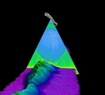


9 Water Column Data Development Photos courtesy of Sheena Fennell (NUIG) Multibeam water column data: Deep Scattering Layer (DSL) Internal Waves Gas Seepage


10 The Data Path (SEAI - OREDP) (DECLG-MSFD / MSP) Fishing intensity BRANDING AWARENESS ACKNOWLEDGEMENT Data Citation PDF Print Screen Traffic / Gas Pipelines

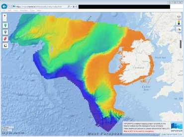

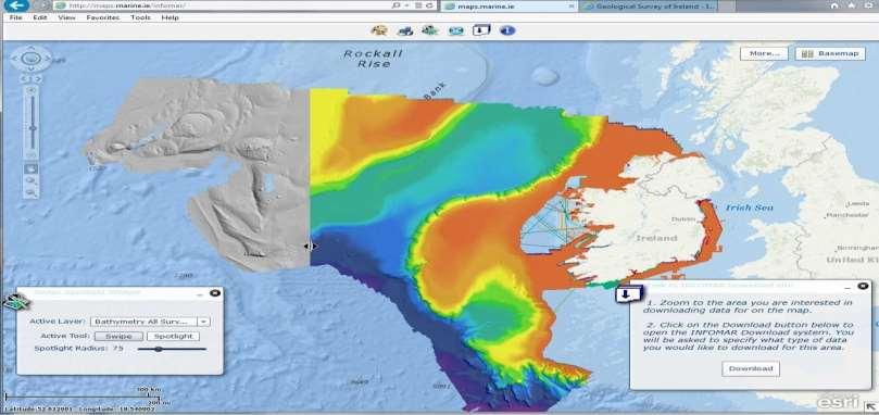
11 Dynamic Web Map Viewer

12 Depth Range: 0-500m

13 Depth Range: 0-100m

14 Slope / Seabed Hardness


15 Habitat Map

16 Creating a Substrate Map 6. Translate final map to modified Folk classes 1. Apply hillshade effect to bathymetric data to highlight rocky outcrops 5. Groundtruth acoustic classes using sediment samples Process 2. Trace rock outcrops from shaded relief using ArcGIS Editor tools 4. Trace acoustic classes from backscatter using ArcGIS Editor tools 3. Display backscatter imagery to view different substrates Stages in the creation of a substrate map using MBES shaded relief and backscatter imagery and sediment samples


17 Creation of Habitat Maps Biological samples Energy Substrate Bathymetry WHY CREATE A HABITAT MAP? Support management decisions BROAD APPROACH: Rasters input layers to Max. Likelihood Classification process (substrate, bathymetry, kinetic energy) Biological samples analysed & grouped by species richness > refine physical habitat map into a high level EUNIS habitat map. Note: Energy data were obtained from the Regional Ocean Modelling System (ROMS).
18 3 rd Party Development Opportunities Industry / Sector Energy: Marine Renewables ICT Tourism & Leisure Resources: Seaweeds Resources: Fishing Survey Industry ( 42m) ( 48m) Opportunities access to knowledge and infrastructure 4D modelling for site selection, array configuration design, device foundation design. Development of data management services, solutions, and technologies for decision support (e.g. Licensing / MSP Tools) 4D visualisation (interpretive centres / cruise liners etc. Tourism app development (e.g. sailing, angling ) Technology & data integration/analytics (Satellite / Lidar / UAV / Acoustics) for intertidal / sub-tidal resource assessment Sustainable & efficient fisheries supported by e.g.; predicted 4D larval dispersion modelling (prawns) spawning ground mapping & protection (herring) fishing efficiency improvements/tools (scallop) Field & computer based training Development of survey services (UAV / laser / image integration) Development of planning, ops and reporting tools Red denotes PWC CBA 2026 potential value to sector from INFOMAR (low impact scenario)

19 Half Way Point The Building Blocks Resources: Expertise (Operations, Data, ICT, Geodesy - marine) 17 technical staff, (& 12 contractors) 5 multibeam fitted survey vessels National & EU support for mapping initiatives Data: Free online data resources & products 55 Tb data holding / 150 Tb server Progressing towards data in your pocket R&D: Remote Sensing & Coastal Resource Assessment Since 2008, 67 INFOMAR projects funded (> 1.75m) Industry/Gov/Academic Research Collaboration
 Solution & innovation focussed (e.")
20 Checkpoint Where are we now? INFOMAR ENABLING DEVELOPMENT? What does INFOMAR do for Ireland s marine economy? Employ, up-skill, services, partner, R&D, global market platform How does INFOMAR support development? Data / Maps / Information Strategically (e.g. OREDP / IOSEAs / MSFD) Solution & innovation focussed (e.g. Decision tools / technology gaps) How is INFOMAR used by industry? Receive our data, advice, survey support, infrastructure access Sell us services, personnel, equipment & software Marketing & prototype testing platform. What s Missing? thomas.furey@marine.ie More groundtruthing... subject: INFOMAR feedback White ribbon mapping... Awareness / Acknowledgement / Impact Tracking...


21 Thank you On Behalf of INFOMAR Team QUESTIONS?
INFOMAR: An Introduction and Invitation to INFOMAR 2012
 INFOMAR: An Introduction and Invitation to INFOMAR 2012 Koen Verbruggen Presented by Janine Guinan Geological Survey of Ireland 10 th October, 2012 GEOSEAS Seminar Cork Context UNCLOS 1996 Area mapped
Rinville, Oranmore, Co. Galway. a thriving maritime economy in harmony with the ecosystem and supported by the delivery of excellence in our services.
 Position Contract Service Group Location Marine Institute Job Description Scientific & Technical Officer, Habitat Mapping Specialist (INFOMAR) Temporary Specified Purpose, up to end 2018 (INFOMAR Funded)
INFOMAR, Coastal Mapping in Ireland needs, costs and results
 INFOMAR, Coastal Mapping in Ireland needs, costs and results Koen Verbruggen Geological Survey of Ireland Kunnskap for Framtida MAREANO Workshop, Trondheim, Norway, 6th Feb 2012 Overview 1. Context - INSS
Innovate UK energy strategy - Rob Saunders A joint approach - Christian Inglis The energy systems catapult - Nick Smailes Project Presentations
 Our changing energy systems: Supporting innovation Innovate UK energy strategy - Rob Saunders A joint approach - Christian Inglis The energy systems catapult - Nick Smailes Project Presentations May 2015
Marine Institute Job Description
 Marine Institute Job Description Position Contract Service Group Location Temporary Systems Administrator Team Leader Temporary Specified Purpose contract for a duration of up to 3 years Ocean Science
Research Infrastructures and Horizon 2020
 Research Infrastructures and Horizon 2020 Christos VASILAKOS DG Research & 1 st CoPoRI Workshop on EoE 11-12 June 2012 Hamburg, DE The EU Framework Programme for Research and 2014-2020 Research and Europe
Marine Institute Job Description
 Marine Institute Job Description Position Contract Service Group Location Temporary Scientific and Technical Officer (STO) - IT Systems Administrator Temporary specified purpose contract for a duration
Annual Report for the Utility Savings Initiative
 Report to the North Carolina General Assembly Annual Report for the Utility Savings Initiative July 1, 2016 June 30, 2017 NORTH CAROLINA DEPARTMENT OF ENVIRONMENTAL QUALITY http://portal.ncdenr.org Page
A Thematic Approach to Data Management and Implementation of INSPIRE: The UK Marine Environmental Data and Information Network
 A Thematic Approach to Data Management and Implementation of INSPIRE: The UK Marine Environmental Data and Information Network Mark Charlesworth mecha@bodc.ac.uk www.oceannet.org Content Importance marine
Telecommunications Strategy
 Telecommunications Strategy Mike Rudd Telecommunications Strategy Manager June 27, 2017 http://www.gov.uk/ukspaceagency Me! Joined UKSA in Aug 16 Career Civil Servant Remit Telecommunications Strategy
GEBCO Update. U.S. - Canada Hydrographic Commission Victoria, B.C., Canada 26 March 2018
 GEBCO Update U.S. - Canada Hydrographic Commission Victoria, B.C., Canada 26 March 2018 The Nippon Foundation-GEBCO Seabed 2030 The Seabed 2030 Establishment Team: Graham Allen, Robin Falconer, David Heydon,
Data, Data, Everywhere. We are now in the Big Data Era.
 Data, Data, Everywhere. We are now in the Big Data Era. CONTENTS Background Big Data What is Generating our Big Data Physical Management of Big Data Optimisation in Data Processing Techniques for Handling
Minneapolis Clean Energy Partnership Energy Vision Advisory Committee (EVAC) 4/16/2015
 4/16/2015") Minneapolis Clean Energy Partnership Energy Vision Advisory Committee (EVAC) 4/16/2015 Agenda 3:00 Welcome & Introductions 3:15 Update on EVAC co-chair 3:20 CEP Background & Charge 3:35 EVAC Structure
Minneapolis Clean Energy Partnership Energy Vision Advisory Committee (EVAC) 4/16/2015 Agenda 3:00 Welcome & Introductions 3:15 Update on EVAC co-chair 3:20 CEP Background & Charge 3:35 EVAC Structure
Towards a pan-european infrastructure for marine and ocean data management + Importance of standards
 Towards a pan-european infrastructure for marine and ocean data management + Importance of standards By Dick M.A. Schaap Technical Coordinator SeaDataNet & Coordinator EMODnet Bathymetry Hydrography Day,
Data Centres and the Planning Process
 Data Centres and the Planning Process 21 st November 2018 Conall Boland Deputy Chairperson Agenda About An Bord Pleanála Planning Process Data Centres recent experience of An Bord Pleanála Key Issues for
ICAS Workshop 3rd October 2005 Single European Sky Implementation Plan - SESAME
 ICAS Workshop 3rd October 2005 Single European Sky Implementation Plan - SESAME Jan Van Doorn EUROCONTROL Experimental Centre, France Director European 1 Organisation for the Safety of Air Navigation Demand
Towards a Canadian Integrated Ocean Observing System
 Towards a Canadian Integrated Ocean Observing System CMOS Luncheon (Ottawa) February 28, 2018 Andrew Stewart Fisheries and Oceans Canada The Ocean is Valuable Ocean Economy: Ocean-based industries Natural
Submission of proposals: Overview & Submission System
 Submission of proposals: Overview & Submission System Dave BAIRD (DIGIT, B1) Victoria BEAZ HIDALGO (EASME, A3 EMFF) #EMFF2018 EMFF-BlueEconomy-2018 call 22 November 2018 Brussels APPLICATON PACKAGE Submission
Foreign Direct Investment (FDI) and Renewable Energy. Donal Flavin, Strategic Policy Manager, IDA Ireland
 and Renewable Energy. Donal Flavin, Strategic Policy Manager, IDA Ireland") Foreign Direct Investment (FDI) and Renewable Energy Donal Flavin, Strategic Policy Manager, IDA Ireland October 11, 2018 Presentation Outline IDA Ireland. Ireland s FDI (Foreign Direct Investment) Sector.
Foreign Direct Investment (FDI) and Renewable Energy Donal Flavin, Strategic Policy Manager, IDA Ireland October 11, 2018 Presentation Outline IDA Ireland. Ireland s FDI (Foreign Direct Investment) Sector.
UK Space Agency Update for CEOS.
 UK Space Agency Update for CEOS http://www.bis.gov.uk/ukspaceagency May 2013 To meet national needs, the UK Space Agency is responsible for ensuring that the UK retains and grows a strategic capability
ATI UK Strategy in Aerospace. Aerospace Technology Congress 2016
 ATI UK Strategy in Aerospace Aerospace Technology Congress 2016 THE ATI Aerospace - delivering broader UK economic impact UK civil aerospace facts 2015 Exports 26 Billion 17% market share Revenues 29 Billion
CANARIE Mandate Renewal Proposal
 CANARIE Mandate Renewal Proposal Kathryn Anthonisen BCNET Conference April 23, 2018 Let s connect! @kanthonisen canarie.ca @canarie_inc canarie.ca @canarie_inc 2 Core Purpose Advancement of Canada s Knowledge
acknowledged by the United Nations University
 Regional Centre of Expertise in Sustainability Education acknowledged by the United Nations University RCE Severn Network RCE Severn is a Regional Centre of Expertise (RCE) for Sustainability Education,
Catapult centres in the UK. David Golding Head of European and Global Engagement
 Catapult centres in the UK David Golding Head of European and Global Engagement Innovate UK UK s innovation agency - a national public body set up by government to stimulate business innovation Sponsored
CLASSIFICATION OF NONPHOTOGRAPHIC REMOTE SENSORS
 CLASSIFICATION OF NONPHOTOGRAPHIC REMOTE SENSORS PASSIVE ACTIVE DIGITAL CAMERA THERMAL (e.g. TIMS) VIDEO CAMERA MULTI- SPECTRAL SCANNERS VISIBLE & NIR MICROWAVE HYPERSPECTRAL (e.g. AVIRIS) SLAR Real Aperture
Arctic Action Overview
 Selected Topics International Arctic Council National Arctic Action Overview Interagency Working Group on Alaska Energy and Permitting Issues [E.O. 13580] Report to the President (March 2013) National
2017 Company Profile
 2017 Company Profile LITS Lead Technology Services 10/2/2017 INTRODUCTION Leading Innovative Technology Solutions (LITS) Lead Innovative Technology Services is an affirmative and black economic empowerment
A SENSOR FUSION APPROACH TO COASTAL MAPPING
 A SENSOR FUSION APPROACH TO COASTAL MAPPING Maryellen Sault, NOAA, National Ocean Service, National Geodetic Survey Christopher Parrish, NOAA, National Ocean Service, National Geodetic Survey Stephen White,
Business Model for Global Platform for Big Data for Official Statistics in support of the 2030 Agenda for Sustainable Development
 Business Model for Global Platform for Big Data for Official Statistics in support of the 2030 Agenda for Sustainable Development Introduction This note sets out a business model for a Global Platform
DANUBIUS-RI, the pan-european distributed research infrastructure supporting interdisciplinary research on river-sea systems
 DANUBIUS-RI, the pan-european distributed research infrastructure supporting interdisciplinary research on river-sea systems Dr. Adrian Stanica, DANUBIUS-RI ESFRI Project Coordinator www.danubius-ri.eu
The Third Party Administrator Model: Right for Puerto Rico?
 The Third Party Administrator Model: Right for Puerto Rico? Scudder Parker Senior Policy Advisor Vermont Energy Investment Corporation (VEIC) About VEIC Nonprofit founded in 1986 Designs, delivers, and
Developing Methodology for Efficient Eelgrass Habitat Mapping Across Lidar Systems
 Developing Methodology for Efficient Eelgrass Habitat Mapping Across Lidar Systems VICTORIA PRICE 1, JENNIFER DIJKSTRA 1, JARLATH O NEIL-DUNNE 2, CHRISTOPHER PARRISH 3, ERIN NAGEL 1, SHACHAK PE ERI 1 UNIVERSITY
The What, Why, Who and How of Where: Building a Portal for Geospatial Data. Alan Darnell Director, Scholars Portal
 The What, Why, Who and How of Where: Building a Portal for Geospatial Data Alan Darnell Director, Scholars Portal What? Scholars GeoPortal Beta release Fall 2011 Production release March 2012 OLITA Award
Seabed Mapping with LiDAR
 Seabed Mapping with LiDAR 2011 Jakarta David Jonas Lt Cdr Rupert Forester-Bennett RN (ret( ret d) October 18 th 2011 Mapping in South East Asia Field Survey Aerial Photography LiDAR Pleased to Introduce
 Plone development in UNEP Country Environmental Profiles Gerard.Cunningham@unep.org Capacity Building and Partnerships Section Division of Early Warning and Assessment United Nations Environment Programme
ehealth Ministerial Conference 2013 Dublin May 2013 Irish Presidency Declaration
 ehealth Ministerial Conference 2013 Dublin 13 15 May 2013 Irish Presidency Declaration Irish Presidency Declaration Ministers of Health of the Member States of the European Union and delegates met on 13
ArcGIS in the Cloud. Andrew Sakowicz & Alec Walker
 ArcGIS in the Cloud Andrew Sakowicz & Alec Walker Key Takeaways How to Identify Organizational Strategy & Priorities Esri s Cloud Offerings A Broad Spectrum Successfully Executing Your Strategy The Cloud
s. Personnel Transmittals CTD SVP. otherequiptype CODA. PhotoStation. Sampling. Video
 BGS MARINE SURVEY FOLDER STRUCTURE The following folder structure has been developed for use during offshore surveys. Feedback on using the folder structure should be sent to offshoredata@bgs.ac.uk. Emails
GRIDS INTRODUCTION TO GRID INFRASTRUCTURES. Fabrizio Gagliardi
 GRIDS INTRODUCTION TO GRID INFRASTRUCTURES Fabrizio Gagliardi Dr. Fabrizio Gagliardi is the leader of the EU DataGrid project and designated director of the proposed EGEE (Enabling Grids for E-science
YOUR REGION FOR BUSINESS. Presentation to the Markham Development Services Committee February 12, 2018
 YOUR REGION FOR BUSINESS Presentation to the Markham Development Services Committee February 12, 2018 Our mandate is focused on strengthening the Toronto Region economy by attracting and supporting greenfield
From the E-readiness Assessment and Analysis to an Action Plan and Policies Recommendations. Gabriel Accascina
 From the E-readiness Assessment and Analysis to an Action Plan and Policies Recommendations Gabriel Accascina gabriel@it4dev.net Contents The E-readiness Assessment (ERA) process and analysis The components
View from a bridge. Collective navigational challenges in comparable sea areas Ringo Lakeman senior policy adviser / CM IMO NCSR 3
 View from a bridge Collective navigational challenges in comparable sea areas Ringo Lakeman senior policy adviser / CM IMO NCSR 3 8th Co-operative Forum Co-operative mechanism on safety of navigation and
Doing Business with Defence. Opportunities and Innovation in the Defence Supply Chain
 Over the next decade we are committed to spending over 178Bn on equipment and support. Defence has a major role to play in delivering the government s growth and enterprise agenda the MOD accounts for
INTAROS Integrated Arctic Observation System
 INTAROS Integrated Arctic Observation System A project funded by EC - H2020-BG-09-2016 Coordinator: Stein Sandven Nansen Environmental and Remote Sensing Center, Norway Overall objective: to develop an
THE ISSUE. TITLE: The East Midlands Business link. Author: Andrew Groom
 THE ISSUE TITLE: The East Midlands Business link Author: Andrew Groom 1 Astrium is a wholly owned subsidiary of EADS: Astrium Space Transportation (launchers and orbital infrastructure) Astrium Satellites
How to get to information without drilling down through a gazillion layers or being a GIS power user
 One Stop Shopping How to get to information without drilling down through a gazillion layers or being a GIS power user Our Mission Managing fish and wildlife resources for their long-term well-being and
Marine Transportation System Resilience: A Federal Agency Perspective
 Marine Transportation System Resilience: A Federal Agency Perspective Katherine Touzinsky, USACE-ERDC TRB-CMTS Biennial Conference, June 21-23 rd, 2016 Resilience Integrated Action Team: Mission and Objectives
UAE National Space Policy Agenda Item 11; LSC April By: Space Policy and Regulations Directory
 UAE National Space Policy Agenda Item 11; LSC 2017 06 April 2017 By: Space Policy and Regulations Directory 1 Federal Decree Law No.1 of 2014 establishes the UAE Space Agency UAE Space Agency Objectives
Transport and ICT Global Practice Smart Connections for All Sandra Sargent, Senior Operations Officer, Transport & ICT GP, The World Bank
 WORLD BANK DONOR PERSPECTIVE ON CYBER SECURITY Transport and ICT Global Practice Smart Connections for All Sandra Sargent, Senior Operations Officer, Transport & ICT GP, The World Bank MYTH NUMBER ONE:
Ervia Risk Management. Elaine O Donoghue IPA Governance Forum Briefing 10 th November 2017
 Ervia Risk Management Elaine O Donoghue IPA Governance Forum Briefing 10 th November 2017 Ervia Overview - Our Structure Our customer facing businesses, Gas Networks Ireland and Irish Water, are supported
Role and relevance of space applications in the wider economy 19 April 2012
 Role and relevance of space applications in the wider economy 19 April 2012 Iain Gray Chief Executive Technology Strategy Board Agenda Introduction to the Technology Strategy Board Our role in Space Space
Driving innova*on and knowledge
 Driving innova*on and knowledge Presentation to Mer-Innovate SPARTA Paul Ellsmore Academic and Cross-Catapult Engagement Manager 29 th October 2014 Catapults: A long-term vision for innovation & growth
National Open Source Strategy
 National Open Source Strategy Ministry of Communications & Information Technology - Egypt June 2014 Outline Background Vision & Mission Preliminary Targets Strategic Objectives Enablers Ministry of Communications
Poland: Initiative for Polish Industry 4.0 The Future Industry Platform
 Digital Transformation Monitor Poland: Initiative for Polish Industry 4.0 The Future Industry Platform February 2018 Internal Market, Industry, Entrepreneurshi p and SMEs Skitterphoto/Pexels.com Country:
Coastal Survey of archaeological sites using drones
 Coastal Survey of archaeological sites using drones In Poseidon s Realm XXI Underwater archaeology - interdisciplinary approaches and technical innovations Dimitrios Skarlatos, Savvidou Eleni Photogrammetric
U.S. DEPARTMENT OF COMMERCE BUREAU OF INDUSTRY AND SECURITY
 U.S. DEPARTMENT OF COMMERCE BUREAU OF INDUSTRY AND SECURITY OFFICE OF TECHNOLOGY EVALUATION INDUSTRIAL STUDIES DIVISION U.S. INTEGRATED CIRCUIT DESIGN & FABRICATION National Defense Industrial Association
The emerging UK space economy: Influencing outcomes and impacts in the Midlands
 The emerging UK space economy: Influencing outcomes and impacts in the Midlands Colin Baldwin UK Space Agency 27 February 2015 http://www.bis.gov.uk/ukspaceagency How can space help me? Credit: ESA/Rosetta/MPS
HawkEye III - A new deep penetrating bathymetric LIDAR system
 Please insert a picture (Insert, Picture, from file). Size according to grey field (10 cm x 25.4 cm). Scale picture: highlight, pull corner point Cut picture: highlight, choose the cutting icon from the
WHO/ITU National ehealth Strategy Toolkit. Joan Dzenowagis
 WHO/ITU National ehealth Strategy Toolkit Joan Dzenowagis National ehealth Strategies: Using the WHO-ITU National ehealth Strategy Toolkit Dr Joan Dzenowagis, WHO HQ 24 September 2013 AeHIN General Meeting
The UK Water Partnership. Business Plan 2018
 The UK Water Partnership Business Plan 2018 Water is essential for the very existence of life; it keeps us and the ecosystems, which we depend on, alive and healthy and is fundamental to our industry,
Software for Hydrographic Data Processing
 Software for Hydrographic Data Processing Data courtesy of Dr. T. Komatsu, Tokyo University Ocean Research Institute CleanSweep provides a fast, user friendly environment for processing hydrographic survey
To Compete You Must Compute
 To Compete You Must Compute Presentation to Society of High Performance Computing Professionals November 3, 2010 Susan Baldwin Executive Director Compute Canada susan.baldwin@computecanada.org Vision To
Crowd-Sourced Bathymetry
 THE INTERNATIONAL HYDROGRAPHIC ORGANIZATION Crowd-Sourced Bathymetry NIOHC16 Chittagong, Bangladesh 14-16 March 2016 We know more about the topography of Mars and our Moon than we do about the topography
Checking the values using backscatter data
 A Technique for using Backscatter Imagery to Calibrate your Multibeam sonar Harold Orlinsky Harold@Hypack.com Checking the values using backscatter data The collection of Backscatter is co located with
Using a Geographic Information System (GIS) to look at marine fisheries data
 to look at marine fisheries data") Using a Geographic Information System (GIS) to look at marine fisheries data Daniel Sheehan GIS Programmer & Analyst Office of Educational Innovation & Technology dsheehan@mit.edu x2-1475 Introduction
Using a Geographic Information System (GIS) to look at marine fisheries data Daniel Sheehan GIS Programmer & Analyst Office of Educational Innovation & Technology dsheehan@mit.edu x2-1475 Introduction
NOAA Integrated Ocean and Coastal Mapping Using Hurricane Sandy Response Data to Help Build a Bridge Between Lidar Bathymetry and The Chart
 NOAA Integrated Ocean and Coastal Mapping Using Hurricane Sandy Response Data to Help Build a Bridge Between Lidar Bathymetry and The Chart JALBTCX Airborne Coastal Mapping and Charting Workshop July 19-21
Building multi-stakeholder partnerships for World Heritage
 Building multi-stakeholder partnerships for World Heritage Partnering for World Heritage Wadden Sea Day 2017 31 August 2017 Marco van der Ree mission statement Bringing organizations, communities and people
Welcome Participants!
 Welcome Participants! Portsmouth Harbor Response Initiative Coastal Response Research Center June 27, 2007 1 Coastal Response Research Center (CRRC) Staff Co-Directors: UNH Nancy Kinner NOAA Amy Merten
ANALYSIS OF THE MORPHODYNAMICS OF THE GERMAN NORTH SEA COAST ON THE BASIS OF A FUNCTIONAL SEABED MODEL. Peter Milbradt1
 ANALYSIS OF THE MORPHODYNAMICS OF THE GERMAN NORTH SEA COAST ON THE BASIS OF A FUNCTIONAL SEABED MODEL Peter Milbradt1 ABSTRACT The knowledge of the hydro- and morphodynamic realities and the resulting
RESPONSE TO 2016 DEFENCE WHITE PAPER APRIL 2016
 RESPONSE TO 2016 DEFENCE WHITE PAPER APRIL 2016 HunterNet Co-Operative Limited T: 02 4908 7380 1 P a g e RESPONSE TO 2016 DEFENCE WHITE PAPER APRIL 2016 Project Manager Marq Saunders, HunterNet Defence
First Session of the Asia Pacific Information Superhighway Steering Committee, 1 2 November 2017, Dhaka, Bangladesh.
 First Session of the Asia Pacific Information Superhighway Steering Committee, 1 2 November 2017, Dhaka, Bangladesh. DRAFT SUBMISSION OF [ORGANIZATION] PROJECTS/ACTIVITIES/STUDIES [Date] Objective: This
McClelland Report. John McClelland CBE, June 2011
 McClelland Report 2 The public sector is lagging where it should be and there is an opportunity to capture a multiplicity of benefits in radically changing how ICT is adopted and deployed and in how it
National Earthquake Risk Reduction Program in Haiti
 National Earthquake Risk Reduction Program in Haiti Goal: Build and maintain Haiti s capability to reduce earthquake risk by implementing an integrated and sustainable program in earthquake science, engineering,
CISE. an INFORMATION SHARING TOOL to support INTEGRATED MARITIME SURVEILLANCE. European Maritime Day Göteborg, May 22 nd 2012
 CISE an INFORMATION SHARING TOOL to support INTEGRATED MARITIME SURVEILLANCE European Maritime Day Göteborg, May 22 nd 2012 Maritime Surveillance: What? WHAT S GOING ON AT SEA? AWARENESS Legitimate Activities
CODEVINTEC. Caris Hydrographic Survey. CARIS HIPS and SIPS CARIS Onboard. Bathy DataBASE 4.4. Bathy DataBASE Server 4.3. BASE Editor 4.
 45 27 39.384 N 9 07 30.145 E Caris Hydrographic Survey Photo: João Ventura da Cruz CARIS HIPS and SIPS 10.4 page 2 CARIS Onboard page 4 Bathy DataBASE 4.4 page 6 Bathy DataBASE Server 4.3 page 7 BASE Editor
JOURNÉE CNES INDUSTRIE 2018 «SATELLITES ET APPLICATIONS» 26 JUIN Pierre LEONARD: marketing & communication
 JOURNÉE CNES INDUSTRIE 2018 «SATELLITES ET APPLICATIONS» 26 JUIN 2018 Pierre LEONARD: marketing & communication Knowledge-based companies Pilar 1 Space Pilar 2 Geo-information Pilar 3 Engineering Holding
Advancements in Area-Based Imagery Processing
 Advancements in Area-Based Imagery Processing An integrated Geocoder delivers a streamlined workflow and new capabilities Alexander MacDonald, CARIS, Canada Corey Collins, CARIS, Canada For many years
CONFERENCE ON SERVICE SCIENCE, MANAGEMENT & ENGINEERING (SSME):
:") CONFERENCE ON SERVICE SCIENCE, MANAGEMENT & ENGINEERING (SSME): Towards Philippine Global Competitiveness In Offshoring & Outsourcing August 5-8, 2008 Audio-Visual Room, CICT Building C.P. Garcia Ave.,
CONFERENCE ON SERVICE SCIENCE, MANAGEMENT & ENGINEERING (SSME): Towards Philippine Global Competitiveness In Offshoring & Outsourcing August 5-8, 2008 Audio-Visual Room, CICT Building C.P. Garcia Ave.,
The EUCISE2020 project
 The EUCISE2020 project (EUropean test bed for the maritime Common Information Sharing Environment in the 2020 perspective) P. Sacco, 16/01/2018 CISE Roadmap Cross Sectorial interoperability for better
Oceansgate Plymouth University
 Oceansgate Plymouth University Feb 2018 Patrick Hartop Head of City Deal patrick.hartop@plymouth.gov.uk Gareth Simmons Strategic Projects Director gareth.simmons@plymouth.gov.uk Why is this so important
Towards a pan-european infrastructure for marine and ocean data management + Importance of standards
 Towards a pan-european infrastructure for marine and ocean data management + Importance of standards By Dick M.A. Schaap MARIS Technical Coordinator SeaDataNet & ODIP Coordinator EMODnet Bathymetry Münster
Gender and technology transfer
 Gender and technology transfer Update by Mr. Fred Onduri CTCN Advisory Board Chair Jukka Uosukainen Director, CTCN www.ctc-n.org ctcn@unep.org CTCN Structure Launched in 2014 Guided by COP & Advisory Board
CenturyLink for Microsoft
 Strategic Partner Alliances CenturyLink for Microsoft EMPOWER REACH AGILITY 2017 CenturyLink. All Rights Reserved. The CenturyLink mark, pathways logo and certain CenturyLink product names are the property
Exploring threats and opportunities through Mega Trends in the Space 4.0 era
 Exploring threats and opportunities through Mega Trends in the Space 4.0 era ESA Mega Trends Team Gianluigi Baldesi 06/03/2018 Objectives of this initiative sharing global mega trends across the Agency
Mass Big Data: Progressive Growth through Strategic Collaboration
 Massachusetts Technology Collaborative Mass Big Data: Progressive Growth through Strategic Collaboration Patrick Larkin, Executive Director The Innovation Institute at the Massachusetts Technology Collaborative
INSPIRE in a nutshell, and overview of the European Union Location Framework
 INSPIRE in a nutshell, and overview of the European Union Location Framework Francesco Pignatelli European Commission, DG JRC 10 th European Congress and Exhibition on Intelligent Transport Systems and
Effects of Marine and Hydrokinetic Energy Development
 Managing Data for Environmental Effects of Marine and Hydrokinetic Energy Development a Knowledge Management System Andrea Copping and Scott Butner Pacific Northwest National Laboratory Data: Managing
Securing Europe's Information Society
 Securing Europe's Information Society Dr. Udo Helmbrecht Executive Director European Network and Information Security Agency 16 June 2010 FIRST AGM Miami 16/6/2010 1 Agenda ENISA overview Challenges EU
Doug Couto Texas A&M Transportation Technology Conference 2017 College Station, Texas May 4, 2017
 Cyber Concerns of Local Government and What Does It Mean to Transportation Doug Couto Texas A&M Transportation Technology Conference 2017 College Station, Texas May 4, 2017 Transportation and Infrastructure
The enabling role of geospatial information in the European energy policies
 The European Commission s science and knowledge service Joint Research Centre The enabling role of geospatial information in the European energy policies Francesco Pignatelli Kehl (DE), 5 September 2017
Smart Sustainable Cities. Trends and Real-World Opportunities
 Smart Sustainable Cities Trends and Real-World Opportunities Role Of The GSMA WE ARE THE GLOBAL INDUSTRY VOICE SHAPING THE FUTURE OF MOBILE INDUSTRY FORUM POLICY ADVOCATE MARKET THINK TANK BUSINESS CATALYST
THE POWER OF TECH-SAVVY BOARDS:
 THE POWER OF TECH-SAVVY BOARDS: LEADERSHIP S ROLE IN CULTIVATING CYBERSECURITY TALENT SHANNON DONAHUE DIRECTOR, INFORMATION SECURITY PRACTICES 1 IT S A RISK-BASED WORLD: THE 10 MOST CRITICAL UNCERTAINTIES
Jane s Defence Industry & Markets Intelligence Centre. Develop Advantage. Mitigate Risk. Capture Opportunity.
 Jane s Defence Industry & Markets Intelligence Centre Develop Advantage. Mitigate Risk. Capture Opportunity. OVERVIEW A challenging marketplace The global A&D industry is facing an increasingly volatile,
GREEN DEFENCE FRAMEWORK
 GREEN DEFENCE FRAMEWORK Approved by the North Atlantic Council in February 2014 GREEN DEFENCE FRAMEWORK OVERVIEW 1. Green Defence could, at this stage, be defined as a multifaceted endeavour cutting across
ENCS The European Network for Cyber Security
 ENCS The European Network for Cyber Security A not-for-profit European Public Private Partnership on cyber security for critical infrastructures Initial focus: smart grids and process control, to be extended
SPACE for SDGs a Global Partnership
 SPACE for SDGs a Global Partnership for the Coordination of the Development, Operation and Utilization of Space related Infrastructure, Data, Information and Services in support of the 2030 Development
F SERIES MULTIBEAM FOR FISHERIES
 SEE IT ALL F SERIES DISCOVER A NEW WORLD WITH THE LATEST INNOVATION FROM WASSP Outstanding performance, versatility and value. That s what you expect and exactly what you get with the new F3 sonar from
DISC: Disruptive Innovation Centre for Space
 DISC: Disruptive Innovation Centre for Space TAS UK and UKspace Supply Chain Event Tony Holt 22 March 2017 Disruptive Innovation for Space Centre - Background Expression of Interest submitted 20 th Feb
ESFRI Strategic Roadmap & RI Long-term sustainability an EC overview
 ESFRI Strategic Roadmap & RI Long-term sustainability an EC overview Margarida Ribeiro European Commission DG Research & B.4 - Research Infrastructure Research and What is ESFRI? An informal body composed
ACCI Recommendations on Long Term Cyberinfrastructure Issues: Building Future Development
 ACCI Recommendations on Long Term Cyberinfrastructure Issues: Building Future Development Jeremy Fischer Indiana University 9 September 2014 Citation: Fischer, J.L. 2014. ACCI Recommendations on Long Term