Seabed Mapping with LiDAR
|
|
|
- Belinda Watkins
- 6 years ago
- Views:
Transcription

 October 18")
1 Seabed Mapping with LiDAR 2011 Jakarta David Jonas Lt Cdr Rupert Forester-Bennett RN (ret( ret d) October 18 th 2011
2 Mapping in South East Asia Field Survey Aerial Photography LiDAR Pleased to Introduce the Next Advance
3 Mapping and Hydrography International Trade and Economy Nautical Charts Ecological Protection Land use / Sea use planning Disaster mitigation & management International Boundaries United Nations Conventions (Laws of the Sea)
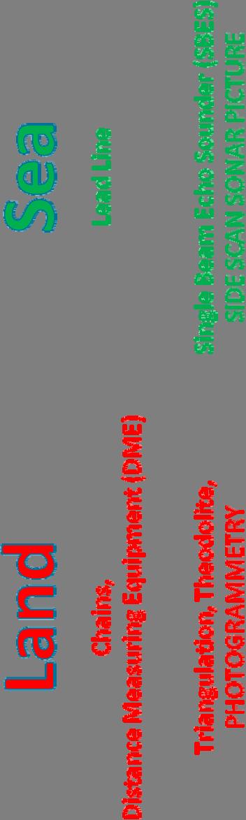


4 Data Collection Techniques 4
5 What does this mean in Practice? C Copyright 2011 Pelydryn Limited; All rights reserved 10

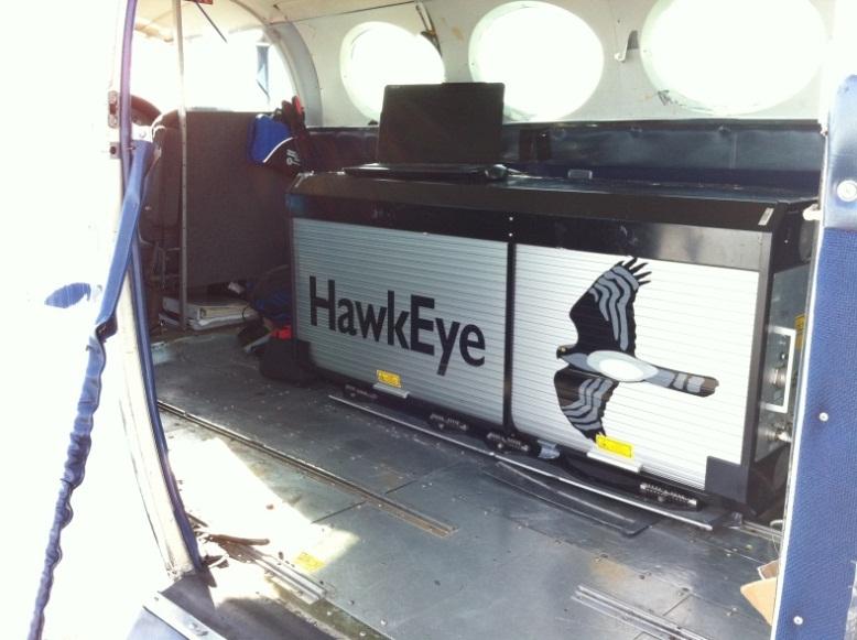
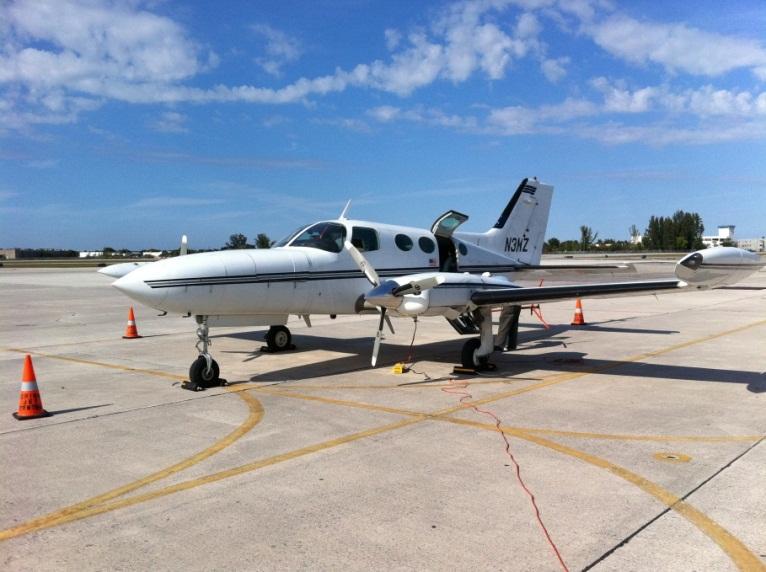

6 Aircraft Small Local 12

7 The depth of water and height of land is measured by laser pulses of two wavelengths; Green (532nm) and Infra Red (IR) (1064nm) The green beam penetrates the water, whereas the IR laser is reflected at the surface. The time difference between the green (bottom) and the IR (water surface) laser reflections is used to calculate the depth. 13

8 Scan Pattern Both lasers are scanned in a pattern on the water surface. The scanning mirror of the LiDAR allows the effects of motion in the platform to be compensated for directly. The scanning mirror compensates for pitch and roll by adjusting the direction in which the laser beams are transmitted, ensuring that they are transmitted ahead of the aircraft at an off nadir angle of 20 and scan left and right either side of the line of advance of the aircraft. The result is a generally evenly spaced pattern of transmissions and returns covering the seabed. 14
 * 15")
9 Advantages/Disadvantages Boat operations suffer from: reduced swathe width slow progress dangerous waters dependence on Mother ship high cost/km 2 White Ribbon (Unsurveyed) * 15

10 Advantages/Disadvantages Bathy LiDAR suffers from: Water Clarity Secchi Disc Scale of Operation C Copyright 2011 Pelydryn Limited; All rights reserved 16
11 Speed and Cost Figures are for guidance, and vary MBES ALB according to local factors Average cost per 1 km 2 of survey 3 1 Average cost of a 350 km 2 survey 3 1 Average time for a 350 km 2 (days) 35 2 C Copyright 2011 Pelydryn Limited; All rights reserved 17

 Areas of vegetation and vegetation type Extent of Rocks and Reefs Brittany: IFREMER")
12 Digital Aerial Photography The HawkEye II B is fitted with a ueye IU 2250 C / M camera Imagery is used to assist in data cleaning Orthophotos are available at a resolution of 25cm when flown at 400m altitude Imagery will also observe ambient sea conditions and phenomena (eddies and over falls) Areas of vegetation and vegetation type Extent of Rocks and Reefs Brittany: IFREMER 22

13 Reflectance Bathymetric data can be processed to produce images of reflectance to aid bottom type classification C Copyright 2011 Pelydryn Limited; All rights reserved 23

14 Topographic Pulse Land topography is measured by the infrared laser only, scanned in a linear pattern. The land topography and the water surface are scanned with a much denser pattern than the seabed as the pulse frequency is much higher at 8000 Hz giving 64,000 returns/second. Recent trials of System 003 revealed the accuracies in the table when flown over a number of preselected topographic features at 400m: Dimension X Y Z Accuracy m m m for individual flight lines m for combined flight lines 24


15 Bathymetric Pulse The HawkEye IIB system is unique in its use of pixelated discrimination. The receivers are divided into : 4 sections for the Hydro receivers (8 sections for the Topo receivers The 4 khz topographic sounding frequency is multiplied by 8) The use of multi pixel technology allows improvements on: data density Contrast object detection object discrimination Bathy Topo C Copyright 2011 Pelydryn Limited; All rights reserved 25

16 Object detection 2m Cube at 18m depth HEIIb meets the object detection requirement of >2m in up to 40m depths C Copyright 2011 Pelydryn Limited; All rights reserved 26


17 Seamless Topo and Bathy data C Copyright 2011 Pelydryn Limited; All rights reserved Maldives Land and Sea 28


18 Current uses of combined Topo/bathy data Maine to New England Survey Area 1500 SqKm US ACE National Coastal Mapping Programme 29
19 Current uses of combined Topo/bathy data New England, USA Data shown courtesy of the USACE National Coastal Mapping Program. 30


20 Current uses of combined Topo/bathy data Maldives: Ministry of Transport, Housing and the Environment Climate Change / Sea Level Rise / Tsunami / Storm Surge Mitigation 31


21 Current uses of combined Topo/bathy data Storm Surge Modeling NOAA Ideal foundation dataset on which to base: Storm Surge/Climate Change modeling Infrastructure design 32
 C Copyright 2011 Pelydryn Limited; All rights reserved")
22 Current uses of combined Topo/bathy data French Hydrographic Office (charting) C Copyright 2011 Pelydryn Limited; All rights reserved 33

23 Current uses of combined Topo/bathy data Irish Government EEZ Delineation C Copyright 2011 Pelydryn Limited; All rights reserved 34

24 C Copyright 2011 Pelydryn Limited; All rights reserved 35
25 Points of Contact AAM David Jonas Spatial Solutions Consultant 152 Wharf Street Brisbane Queensland 4000 Australia Tel: +61 (0) E Mail: D.Jonas@aamgroup.com Mobile: +61 (0) Pelydryn David Lye OBE Deputy MD and Head Business Development Pelydryn Limited Scott 1 Tamar Science Park 1 Davy Road Derriford PLYMOUTH, Devon United Kingdom PL6 8BX Tel: +44(0) E mail: david@pelydryn.co.uk Mobile: +44(0) C Copyright 2011 Pelydryn Limited; All rights reserved 44
HawkEye III - A new deep penetrating bathymetric LIDAR system
 Please insert a picture (Insert, Picture, from file). Size according to grey field (10 cm x 25.4 cm). Scale picture: highlight, pull corner point Cut picture: highlight, choose the cutting icon from the
RIEGL VQ 880 G Laser Scanner System for Topo Bathymetric Surveying. IR laser scanner channel OCTOBER 2015
 RIEGL VQ 880 G Laser Scanner System for Topo Bathymetric Surveying with NEW optional IR laser scanner channel OCTOBER 2015 VQ 880 G Highlights excellently suited for combined hydrographic and topographic
CLASSIFICATION OF NONPHOTOGRAPHIC REMOTE SENSORS
 CLASSIFICATION OF NONPHOTOGRAPHIC REMOTE SENSORS PASSIVE ACTIVE DIGITAL CAMERA THERMAL (e.g. TIMS) VIDEO CAMERA MULTI- SPECTRAL SCANNERS VISIBLE & NIR MICROWAVE HYPERSPECTRAL (e.g. AVIRIS) SLAR Real Aperture
Data Acquisition; Maintenance, and Dissemination
 Data Acquisition; Maintenance, and Dissemination Amar Nayegandhi, CP, CMS(RS), GISP Director of Remote Sensing Dewberry December 4, 2014 About MAPPS + MAPPS is the only national association of private
Victorian Coastline LiDAR Survey 2008 / 2009
 Victorian Coastline LiDAR Survey 2008 / 2009 Airborne LiDAR Bathymetric Survey for Climate Change Victorian Future Coasts Bathymetric LiDAR Survey 2008 / 2009 Mark Sinclair Dr Nathan Quadros Sydney, Australia,
About LIDAR Data. What Are LIDAR Data? How LIDAR Data Are Collected
 1 of 6 10/7/2006 3:24 PM Project Overview Data Description GIS Tutorials Applications Coastal County Maps Data Tools Data Sets & Metadata Other Links About this CD-ROM Partners About LIDAR Data What Are
LIDAR an Introduction and Overview
 LIDAR an Introduction and Overview Rooster Rock State Park & Crown Point. Oregon DOGAMI Lidar Project Presented by Keith Marcoe GEOG581, Fall 2007. Portland State University. Light Detection And Ranging
HYDROFEST 2005 CAPABILITIES OF A MODERN BATHYMETRIC LIDAR SYSTEM - THE SHOALS 1000T SYSTEM. Bill Gilmour Fugro Pelagos Inc, San Diego, CA, USA
 HYDROFEST 2005 CAPABILITIES OF A MODERN BATHYMETRIC LIDAR SYSTEM - THE SHOALS 1000T SYSTEM Bill Gilmour Fugro Pelagos Inc, San Diego, CA, USA ACKNOWLEDGEMENTS FUGRO PELAGOS INC. David Millar Carol Lockhart
SHALLOW SOUNDING BATHYMETRIC USING MULTIBEAM ECHOSOUNDER AND TOPOGRAPHIC LASER SCANNER
 SHALLOW SOUNDING BATHYMETRIC USING MULTIBEAM ECHOSOUNDER AND TOPOGRAPHIC LASER SCANNER BY : NURSUGI, TRI PATMASARI & KHAFID GEOSPASIAL INFORMATION AGENCY AMSTERDAM, 11-14 NOVEMBER 2014 Indonesia coastline
An Introduction to Lidar & Forestry May 2013
 An Introduction to Lidar & Forestry May 2013 Introduction to Lidar & Forestry Lidar technology Derivatives from point clouds Applied to forestry Publish & Share Futures Lidar Light Detection And Ranging
Eunmi Chang, Hyo-Hyun Sung, Jaeyeong Roh, Eunyoung Kim
 Eunmi Chang, Hyo-Hyun Sung, Jaeyeong Roh, Eunyoung Kim Ziinconsulting INC., Ewha Woman s University Korean Hydrographic and Oceanographic Administration Geostrory INC. Based on (IMO Res. A 884(21)) Marine
Course Outline (1) #6 Data Acquisition for Built Environment. Fumio YAMAZAKI
 #6 Data Acquisition for Built Environment. Fumio YAMAZAKI") AT09.98 Applied GIS and Remote Sensing for Disaster Mitigation #6 Data Acquisition for Built Environment 9 October, 2002 Fumio YAMAZAKI yamazaki@ait.ac.th http://www.star.ait.ac.th/~yamazaki/ Course Outline
AT09.98 Applied GIS and Remote Sensing for Disaster Mitigation #6 Data Acquisition for Built Environment 9 October, 2002 Fumio YAMAZAKI yamazaki@ait.ac.th http://www.star.ait.ac.th/~yamazaki/ Course Outline
LIDAR MAPPING FACT SHEET
 1. LIDAR THEORY What is lidar? Lidar is an acronym for light detection and ranging. In the mapping industry, this term is used to describe an airborne laser profiling system that produces location and
SLR, Climate Change, Infrastructure Solutions, Adaption and GIS
 Presenters: Francisco D Elia B.S., M.Sc. Geographic Information Systems Franciscodelia@miamibeachfl.gov Nestor Navarro, GISP, MCSA GIS Manager Nestornavarro@miamibeachfl.gov Data Acquisition, Integration
ALS40 Airborne Laser Scanner
 ALS40 Airborne Laser Scanner Airborne LIDAR for Professionals High Performance Laser Scanning Direct Measurement of Ground Surface from the Air The ALS40 Airborne Laser Scanner measures the topography
Mayden VP of Business Development Surdex Corporation
 Making Sense of Sensors Randy Mayden, Mayden VP of Business Development Surdex Corporation randym@surdex.com EARLYAERIAL PHOTOGRAPHY 2 FIRSTAERIAL CAMERA 3 AERIAL CAMERA SYSTEM DEVELOPMENT Aerial Camera
LiDAR & Orthophoto Data Report
 LiDAR & Orthophoto Data Report Tofino Flood Plain Mapping Data collected and prepared for: District of Tofino, BC 121 3 rd Street Tofino, BC V0R 2Z0 Eagle Mapping Ltd. #201 2071 Kingsway Ave Port Coquitlam,
Airborne LiDAR Data Acquisition for Forestry Applications. Mischa Hey WSI (Corvallis, OR)
") Airborne LiDAR Data Acquisition for Forestry Applications Mischa Hey WSI (Corvallis, OR) WSI Services Corvallis, OR Airborne Mapping: Light Detection and Ranging (LiDAR) Thermal Infrared Imagery 4-Band
Airborne LiDAR Data Acquisition for Forestry Applications Mischa Hey WSI (Corvallis, OR) WSI Services Corvallis, OR Airborne Mapping: Light Detection and Ranging (LiDAR) Thermal Infrared Imagery 4-Band
2-4 April 2019 Taets Art and Event Park, Amsterdam CLICK TO KNOW MORE
 Co-Host Host 2-4 April 2019 Taets Art and Event Park, Amsterdam CLICK TO KNOW MORE Presentation Outline review modern survey methodologies available to support railway requirements measuring everything
Terrain Modeling and Mapping for Telecom Network Installation Using Scanning Technology. Maziana Muhamad
 Terrain Modeling and Mapping for Telecom Network Installation Using Scanning Technology Maziana Muhamad Summarising LiDAR (Airborne Laser Scanning) LiDAR is a reliable survey technique, capable of: acquiring
Better detection and discrimination of seagrasses using fused bathymetric lidar and hyperspectral data
 Better detection and discrimination of seagrasses using fused bathymetric lidar and hyperspectral data Bruce Sabol and Molly Reif US Army Engineer Research and Development Center, Environmental Laboratory
Who we are Swathe Services offers: Equipment Sales Equipment Rental Experience Hydrographic Surveyors Turn-key survey support
 Swathe Services our results speak for themselves Who we are Swathe Services offers: Equipment Sales Equipment Rental Experience Hydrographic Surveyors Turn-key survey support Dissertation Title High Resolution
N.J.P.L.S. An Introduction to LiDAR Concepts and Applications
 N.J.P.L.S. An Introduction to LiDAR Concepts and Applications Presentation Outline LIDAR Data Capture Advantages of Lidar Technology Basics Intensity and Multiple Returns Lidar Accuracy Airborne Laser
Wednesday, July 15, Author: Eldris Ferrer Gonzalez, M.Sc. Engineering CSA Group
 Twenty ninth Annual ESRI International User Conference Wednesday, July 15, 2009 Author: Eldris Ferrer Gonzalez, M.Sc. Engineering CSA Group Introduction to Valenciano Project LIDAR Survey for Valenciano
Lecture 11. LiDAR, RADAR
 NRMT 2270, Photogrammetry/Remote Sensing Lecture 11 Calculating the Number of Photos and Flight Lines in a Photo Project LiDAR, RADAR Tomislav Sapic GIS Technologist Faculty of Natural Resources Management
Airborne Laser Scanning: Remote Sensing with LiDAR
 Airborne Laser Scanning: Remote Sensing with LiDAR ALS / LIDAR OUTLINE Laser remote sensing background Basic components of an ALS/LIDAR system Two distinct families of ALS systems Waveform Discrete Return
Light Detection and Ranging (LiDAR)
") Light Detection and Ranging (LiDAR) http://code.google.com/creative/radiohead/ Types of aerial sensors passive active 1 Active sensors for mapping terrain Radar transmits microwaves in pulses determines
Light Detection and Ranging (LiDAR) http://code.google.com/creative/radiohead/ Types of aerial sensors passive active 1 Active sensors for mapping terrain Radar transmits microwaves in pulses determines
Aerial and Mobile LiDAR Data Fusion
 Creating Value Delivering Solutions Aerial and Mobile LiDAR Data Fusion Dr. Srini Dharmapuri, CP, PMP What You Will Learn About LiDAR Fusion Mobile and Aerial LiDAR Technology Components & Parameters Project
THE USE OF TERRESTRIAL LASER SCANNING FOR MEASUREMENTS IN SHALLOW-WATER: CORRECTION OF THE 3D COORDINATES OF THE POINT CLOUD
 Photogrammetry and Remote Sensing Published as: Deruyter, G., Vanhaelst, M., Stal, C., Glas, H., De Wulf, A. (2015). The use of terrestrial laser scanning for measurements in shallow-water: correction
Measuring the potential impact of offshore mining on coastal instability through integrated time-series laser scanning and photography
 Measuring the potential impact of offshore mining on coastal instability through integrated time-series laser scanning and photography by Neil Slatcher, Roberto Vargas, Chris Cox and Liene Starka, 3D Laser
SPAR, ELMF 2013, Amsterdam. Laser Scanning on the UK Highways Agency Network. Hamish Grierson Blom Uk
 SPAR, ELMF 2013, Amsterdam Laser Scanning on the UK Highways Agency Network Hamish Grierson Blom Uk www.blomasa.com www.blom-uk.co.uk Blom UK Part of the Blom Group Blom Group - Europe s largest aerial
Remote Sensing Sensor Integration
 Remote Sensing Sensor Integration Erica Tharp LiDAR Supervisor Table of Contents About 3001 International Inc Remote Sensing Platforms Why Sensor Integration? Technical Aspects of Sensor Integration Limitations
LiDAR data overview. Dr. Keiko Saito Global Facility for Disaster Reduction and Recovery (GFDRR)
") LiDAR data overview Dr. Keiko Saito Global Facility for Disaster Reduction and Recovery (GFDRR) LiDAR (Light Detecting And Ranging) 3D height profile Laser emitted from sensor onboard aircraft to measure
LiDAR data overview Dr. Keiko Saito Global Facility for Disaster Reduction and Recovery (GFDRR) LiDAR (Light Detecting And Ranging) 3D height profile Laser emitted from sensor onboard aircraft to measure
Learning Objectives LIGHT DETECTION AND RANGING. Sensing. Blacksburg, VA July 24 th 30 th, 2010 LiDAR: Mapping the world in 3-D Page 1
 LiDAR: Mapping the world in 3-D Val Thomas Department of Forest Resources & Environmental Conservation July 29, 2010 Learning Objectives Part 1: Lidar theory What is lidar? How does lidar work? What are
ANALYSIS OF MIDDLE PULSE DATA BY LIDAR IN THE FOREST
 ANALYSIS OF MIDDLE PULSE DATA BY LIDAR IN THE FOREST Katsutoshi. OKAZAKI a, *, Noritsuna. FUJII a a Asia Air Survey Co.Ltd,, 1-2-2, Manpukuji, Asao-ku, Kawasaki, Kanagawa, Japan - (kts.okazaki, nor.fujii)@ajiko.co.jp
NOAA Integrated Ocean and Coastal Mapping Using Hurricane Sandy Response Data to Help Build a Bridge Between Lidar Bathymetry and The Chart
 NOAA Integrated Ocean and Coastal Mapping Using Hurricane Sandy Response Data to Help Build a Bridge Between Lidar Bathymetry and The Chart JALBTCX Airborne Coastal Mapping and Charting Workshop July 19-21
LiDAR data pre-processing for Ghanaian forests biomass estimation. Arbonaut, REDD+ Unit, Joensuu, Finland
 LiDAR data pre-processing for Ghanaian forests biomass estimation Arbonaut, REDD+ Unit, Joensuu, Finland Airborne Laser Scanning principle Objectives of the research Prepare the laser scanning data for
EXTRACTING SURFACE FEATURES OF THE NUECES RIVER DELTA USING LIDAR POINTS INTRODUCTION
 EXTRACTING SURFACE FEATURES OF THE NUECES RIVER DELTA USING LIDAR POINTS Lihong Su, Post-Doctoral Research Associate James Gibeaut, Associate Research Professor Harte Research Institute for Gulf of Mexico
Third Rock from the Sun
 Geodesy 101 AHD LiDAR Best Practice The Mystery of LiDAR Best Practice Glenn Jones SSSi GIS in the Coastal Environment Batemans Bay November 9, 2010 Light Detection and Ranging (LiDAR) Basic principles
Mapping Project Report Table of Contents
 LiDAR Estimation of Forest Leaf Structure, Terrain, and Hydrophysiology Airborne Mapping Project Report Principal Investigator: Katherine Windfeldt University of Minnesota-Twin cities 115 Green Hall 1530
Phone: (603) Fax: (603) Table of Contents
 Fax: (603) Table of Contents") Hydrologic and topographic controls on the distribution of organic carbon in forest Soils LIDAR Mapping Project Report Principal Investigator: Adam Finkelman Plumouth State University Plymouth State University,
Hydrologic and topographic controls on the distribution of organic carbon in forest Soils LIDAR Mapping Project Report Principal Investigator: Adam Finkelman Plumouth State University Plymouth State University,
Leica Systems Overview
 RC30 AERIAL CAMERA SYSTEM Leica Systems Overview The Leica RC30 aerial film camera is the culmination of decades of development, started with Wild's first aerial camera in the 1920s. Beautifully engineered
A Method to Create a Single Photon LiDAR based Hydro-flattened DEM
 A Method to Create a Single Photon LiDAR based Hydro-flattened DEM Sagar Deshpande 1 and Alper Yilmaz 2 1 Surveying Engineering, Ferris State University 2 Department of Civil, Environmental, and Geodetic
Field Integration of Lidar and Sonar Hydrographic Surveys
 Field Integration of Lidar and Sonar Hydrographic Surveys Nicholas Gianoutsos, LTJG Samuel Greenaway, LT Benjamin K. Evans, CDR Guy T. Noll National Oceanic & Atmospheric Administration, National Ocean
IMAGINE Objective. The Future of Feature Extraction, Update & Change Mapping
 IMAGINE ive The Future of Feature Extraction, Update & Change Mapping IMAGINE ive provides object based multi-scale image classification and feature extraction capabilities to reliably build and maintain
Ocean High Technology Institute, Inc. Tadahiko Katsura Japan Hydrographic Association
 Technical Aspects of Marine Scientific Research for Continental Shelf Outer Limits: Advanced Method of Multi-beam Data Processing to Obtain Detailed and Precise Bathymetry Yasutaka Yokoi Ocean High Technology
Feature Detection Performance of a Bathymetric Lidar in Saipan
 Feature Detection Performance of a Bathymetric Lidar in Saipan LTJG Russell Quintero NOAA National Geodetic Survey - JALBTCX, Kiln, MS russell.quintero@noaa.gov Jerry Mills NOAA Office of Coast Survey
APPENDIX E2. Vernal Pool Watershed Mapping
 APPENDIX E2 Vernal Pool Watershed Mapping MEMORANDUM To: U.S. Fish and Wildlife Service From: Tyler Friesen, Dudek Subject: SSHCP Vernal Pool Watershed Analysis Using LIDAR Data Date: February 6, 2014
MULTISPECTRAL MAPPING
 VOLUME 5 ISSUE 1 JAN/FEB 2015 MULTISPECTRAL MAPPING 8 DRONE TECH REVOLUTION Forthcoming order of magnitude reduction in the price of close-range aerial scanning 16 HANDHELD SCANNING TECH 32 MAX MATERIAL,
An Overview of Applanix.
 An Overview of Applanix The Company The Industry Leader in Developing Aided Inertial Technology Founded on Canadian Aerospace and Defense Industry Expertise Providing Precise Position and Orientation Systems
Leica ALS70. Airborne Laser Scanners Performance for diverse Applications
 Leica ALS70 Airborne Laser Scanners Performance for diverse Applications Three Models, One Result. Highest Productivity in all Applications. Imagine an affordable 500 khz pulse rate city-mapping LIDAR
1. LiDAR System Description and Specifications
 High Point Density LiDAR Survey of Mayapan, MX PI: Timothy S. Hare, Ph.D. Timothy S. Hare, Ph.D. Associate Professor of Anthropology Institute for Regional Analysis and Public Policy Morehead State University
NATIONWIDE POINT CLOUDS AND 3D GEO- INFORMATION: CREATION AND MAINTENANCE GEORGE VOSSELMAN
 NATIONWIDE POINT CLOUDS AND 3D GEO- INFORMATION: CREATION AND MAINTENANCE GEORGE VOSSELMAN OVERVIEW National point clouds Airborne laser scanning in the Netherlands Quality control Developments in lidar
LIDAR and Terrain Models: In 3D!
 LIDAR and Terrain Models: In 3D! Stuart.green@teagasc.ie http://www.esri.com/library/whitepapers/pdfs/lidar-analysis-forestry.pdf http://www.csc.noaa.gov/digitalcoast/_/pdf/refinement_of_topographic_lidar_to_create_a_bare_e
Overview. 1. Aerial LiDAR in Wisconsin (20 minutes) 2. Demonstration of data in CAD (30 minutes) 3. High Density LiDAR (20 minutes)
 2. Demonstration of data in CAD (30 minutes) 3. High Density LiDAR (20 minutes)") Overview 1. Aerial LiDAR in Wisconsin (20 minutes) 2. Demonstration of data in CAD (30 minutes) 3. High Density LiDAR (20 minutes) 4. Aerial lidar technology advancements (15 minutes) 5. Q & A 1. Aerial
Overview 1. Aerial LiDAR in Wisconsin (20 minutes) 2. Demonstration of data in CAD (30 minutes) 3. High Density LiDAR (20 minutes) 4. Aerial lidar technology advancements (15 minutes) 5. Q & A 1. Aerial
MODELLING FOREST CANOPY USING AIRBORNE LIDAR DATA
 MODELLING FOREST CANOPY USING AIRBORNE LIDAR DATA Jihn-Fa JAN (Taiwan) Associate Professor, Department of Land Economics National Chengchi University 64, Sec. 2, Chih-Nan Road, Taipei 116, Taiwan Telephone:
HAWAII KAUAI Survey Report. LIDAR System Description and Specifications
 HAWAII KAUAI Survey Report LIDAR System Description and Specifications This survey used an Optech GEMINI Airborne Laser Terrain Mapper (ALTM) serial number 06SEN195 mounted in a twin-engine Navajo Piper
LiDAR Remote Sensing Data Collection: Yaquina and Elk Creek Watershed, Leaf-On Acquisition
 LiDAR Remote Sensing Data Collection: Yaquina and Elk Creek Watershed, Leaf-On Acquisition Submitted by: 4605 NE Fremont, Suite 211 Portland, Oregon 97213 April, 2006 Table of Contents LIGHT DETECTION
Bringing Singapore to life in 3D
 Bringing Singapore to life in 3D Dr Victor Khoo, Deputy Director Singapore Land Authority Bringing Singapore to life in 3D ESRI Singapore UC 2016 Dr. Victor Khoo Singapore Land Authority SLA 2016 RESTRICTED
Developing Methodology for Efficient Eelgrass Habitat Mapping Across Lidar Systems
 Developing Methodology for Efficient Eelgrass Habitat Mapping Across Lidar Systems VICTORIA PRICE 1, JENNIFER DIJKSTRA 1, JARLATH O NEIL-DUNNE 2, CHRISTOPHER PARRISH 3, ERIN NAGEL 1, SHACHAK PE ERI 1 UNIVERSITY
THINK RESILIENCY 2.0 WITH VIZONOMY
 VIZONOMY // 01 ABOUT US The greatest advances in climate risk awareness will be those that merge, harness, and properly communicate big data sources to drive meaningful action and response. Vizonomy s
LiDAR Surveying and the UAS Phenomenon: Understanding How to See the Wood for the Trees
 LiDAR Surveying and the UAS Phenomenon: Understanding How to See the Wood for the Trees Craig Emrick, PSM Vice-President of Mapping Services Prepared For: 51 st Transmission and Substation Design and Operation
UAS based laser scanning for forest inventory and precision farming
 UAS based laser scanning for forest inventory and precision farming M. Pfennigbauer, U. Riegl, P. Rieger, P. Amon RIEGL Laser Measurement Systems GmbH, 3580 Horn, Austria Email: mpfennigbauer@riegl.com,
Quinnipiac Post Flight Aerial Acquisition Report
 Quinnipiac Post Flight Aerial Acquisition Report August 2011 Post-Flight Aerial Acquisition and Calibration Report FEMA REGION 1 Quinnipiac Watershed, Connecticut, Massachusesetts FEDERAL EMERGENCY MANAGEMENT
Municipal Projects in Cambridge Using a LiDAR Dataset. NEURISA Day 2012 Sturbridge, MA
 Municipal Projects in Cambridge Using a LiDAR Dataset NEURISA Day 2012 Sturbridge, MA October 15, 2012 Jeff Amero, GIS Manager, City of Cambridge Presentation Overview Background on the LiDAR dataset Solar
Innovation in 3D. Product Overview
 Innovation in 3D Product Overview TERRESTRIAL LASER SCANNING VQ-1560i MULTIPLE-TIME- AROUND-PROCESSING VZ-400i ECHO DIGITIZATION AIRBORNE LASER SCANNING VUX-1UAV HIGHLY ACCURATE EFFICIENT LIGHTWEIGHT RiCOPTER
Trimble GeoSpatial Products
 Expanding Solutions for Photogrammetric and Remote Sensing Professionals 55 th Photogrammetric Week in Stuttgart September 7 th 2015 Tobias Heuchel, Trimble Stuttgart, Germany Trimble GeoSpatial Products
Center for Advanced Imaging LADAR. A 3D Texel Camera
 Center for Advanced Imaging LADAR Utah State University A 3D Texel Camera Kylee Sealy Industry Day 12/28/2006 Problem/Opportunity Existing 3D Cameras: > Systems are relatively slow and awkward > Hard to
High resolution survey and orthophoto project of the Dosso-Gaya region in the Republic of Niger. by Tim Leary, Woolpert Inc.
 High resolution survey and orthophoto project of the Dosso-Gaya region in the Republic of Niger by Tim Leary, Woolpert Inc. Geospatial Solutions Photogrammetry & Remote Sensing LiDAR Professional Surveying
A SENSOR FUSION APPROACH TO COASTAL MAPPING
 A SENSOR FUSION APPROACH TO COASTAL MAPPING Maryellen Sault, NOAA, National Ocean Service, National Geodetic Survey Christopher Parrish, NOAA, National Ocean Service, National Geodetic Survey Stephen White,
Lidar Sensors, Today & Tomorrow. Christian Sevcik RIEGL Laser Measurement Systems
 Lidar Sensors, Today & Tomorrow Christian Sevcik RIEGL Laser Measurement Systems o o o o Online Waveform technology Stand alone operation no field computer required Remote control through wireless network
CIEEM, Irish Section Conference & AGM Tommy Furey, Marine Institute, Ireland. & Koen Verbruggen, Director, GSI
 INFOMAR application of integrated mapping approaches and technologies to deliver baseline seabed and habitat mapping for Ireland CIEEM, Irish Section Conference & AGM 2016 Tommy Furey, Marine Institute,
Teanaway Streams Topobathymetric LiDAR
 November 23, 2015 Teanaway Streams Topobathymetric LiDAR Technical Data Report Andrew Norton Puget Sound LiDAR Consortium 1011 Western Avenue, Suite 500 Seattle, WA 98104 PH: 206-971-3283 QSI Corvallis
Creating a Custom DEM and Measuring Bathymetric Change for the Multnomah Channel & Willamette River Confluence
 Creating a Custom DEM and Measuring Bathymetric Change for the Multnomah Channel & Willamette River Confluence Meara Butler Josh Schane GEOG 593 Fall 2012 Multnomah Channel begins three miles upstream
Automated Feature Extraction from Aerial Imagery for Forestry Projects
 Automated Feature Extraction from Aerial Imagery for Forestry Projects Esri UC 2015 UC706 Tuesday July 21 Bart Matthews - Photogrammetrist US Forest Service Southwestern Region Brad Weigle Sr. Program
Should Contours Be Generated from Lidar Data, and Are Breaklines Required? Lidar data provides the most
 Should Contours Be Generated from Lidar Data, and Are Breaklines Required? Lidar data provides the most accurate and reliable representation of the topography of the earth. As lidar technology advances
Terrestrial GPS setup Fundamentals of Airborne LiDAR Systems, Collection and Calibration. JAMIE YOUNG Senior Manager LiDAR Solutions
 Terrestrial GPS setup Fundamentals of Airborne LiDAR Systems, Collection and Calibration JAMIE YOUNG Senior Manager LiDAR Solutions Topics Terrestrial GPS reference Planning and Collection Considerations
InteLAS Family of Mobile LiDAR Systems
 InteLAS Family of Mobile LiDAR Systems September 2015 What we do ilinks Geosolutions LLC Hydrographic surveying and seabed modeling Topographic surveying and mobile mapping Systems engineering and integration
Leica ALS80 Airborne Laser Scanners Performance for every Application
 Leica ALS80 Airborne Laser Scanners Performance for every Application Three Models, One Result. Highest Productivity in all Applications. Imagine an affordable city-mapping LIDAR system with an industry-leading
A step by step introduction to TopoFlight
 November 20, 2014 TopoFlight_First_Steps.docx 2004057./KB/04 A step by step introduction to TopoFlight Content 1 Introduction...2 2 Creating the area of interest with GoogleEarth...2 3 Creating the TopoFlight
Security and Disaster Preparedness: New York s Experience. Presented by: New York Department of Public Service. December 7, James T.
 Security and Disaster Preparedness: New York s Experience Presented by: James T. Gallagher New York Department of Public Service james_gallagher@dps.state.ny.us December 7, 2001 Rome, Italy 1 Security
REMOTE SENSING LiDAR & PHOTOGRAMMETRY 19 May 2017
 REMOTE SENSING LiDAR & PHOTOGRAMMETRY 19 May 2017 SERVICES Visual Inspections Digital Terrain Models Aerial Imagery Volume Computations Thermal Inspections Photo maps Aerial Video Training & Consultancy
INFOMAR: An Introduction and Invitation to INFOMAR 2012
 INFOMAR: An Introduction and Invitation to INFOMAR 2012 Koen Verbruggen Presented by Janine Guinan Geological Survey of Ireland 10 th October, 2012 GEOSEAS Seminar Cork Context UNCLOS 1996 Area mapped
Software for Hydrographic Data Processing
 Software for Hydrographic Data Processing Data courtesy of Dr. T. Komatsu, Tokyo University Ocean Research Institute CleanSweep provides a fast, user friendly environment for processing hydrographic survey
Topo-bathymetric Lidar Research to support Remediation of Boat Harbour
 Topo-bathymetric Lidar Research to support Remediation of Boat Harbour Prepared by Applied Geomatics Research Group NSCC, Middleton Tel. 902 825 5475 email: tim.webster@nscc.ca Submitted to Public Services
Coastal Survey of archaeological sites using drones
 Coastal Survey of archaeological sites using drones In Poseidon s Realm XXI Underwater archaeology - interdisciplinary approaches and technical innovations Dimitrios Skarlatos, Savvidou Eleni Photogrammetric
Earthmate PN-60w GPS Details Key Features:
 Earthmate PN-60w GPS Details Key Features: Earthmate PN-60w with SPOT Satellite Communicator» 3.5 GB of internal flash memory» Intuitive icon-based user interface for easy on-device navigation» Elevation
GEOACOUSTICS GEOSWATH PLUS DATA PROCESSING WITH CARIS HIPS 8.1
 GEOACOUSTICS GEOSWATH PLUS DATA PROCESSING WITH CARIS HIPS 8.1 IN SUPPORT OF SANDY SUPPLEMENTAL RESEARCH Val Schmidt and Kevin Jerram University of New Hampshire Center for Coastal and Ocean Mapping Sunken
UNIT 22. Remote Sensing and Photogrammetry. Start-up. Reading. In class discuss the following questions:
 UNIT 22 Remote Sensing and Photogrammetry Start-up In class discuss the following questions: A. What do you know about remote sensing? B. What does photogrammetry do? C. Is there a connection between the
Phone: Fax: Table of Contents
 Geomorphic Characterization of Precarious Rock Zones LIDAR Mapping Project Report Principal Investigator: David E. Haddad Arizona State University ASU School of Earth and Space
MONITORING COASTAL INSTABILITY USING AIRBORNE AND TERRESTRIAL LIDAR
 MONITORING COASTAL INSTABILITY USING AIRBORNE AND TERRESTRIAL LIDAR A Coastal Challenge Monitoring coastlines is a challenging task, especially due to the typically inaccessible nature of the coastal terrain.
AIRBORNE LIDAR TECHNOLOGY FOR UTILITY MAPPING
 GROUND DATA SOLUTIONS R&D SDN BHD Co. No-710842-H AIRBORNE LASER MAPPING REMOTE SENSING GEOGRAPHIC INFORMATION SYSTEM (GIS) ENGINEERING SURVEY AIRBORNE LIDAR TECHNOLOGY FOR UTILITY MAPPING PRESENTATION
Alaska Department of Transportation Roads to Resources Project LiDAR & Imagery Quality Assurance Report Juneau Access South Corridor
 Alaska Department of Transportation Roads to Resources Project LiDAR & Imagery Quality Assurance Report Juneau Access South Corridor Written by Rick Guritz Alaska Satellite Facility Nov. 24, 2015 Contents
2017 PROGRAM OVERVIEW. Geospatial Intelligence for Better Outcomes
 2017 PROGRAM OVERVIEW Geospatial Intelligence for Better Outcomes NICB SOLUTION : GEOSPATIAL INTELLIGENCE CENTER Key Program Areas 1. CAT / Disaster Response 2. National Imagery Program 3. Digital Delivery
ixu-rs1900 Aerial Solutions
 Aerial Solutions Seeing the Large Picture Medium Format Evolves Aerial Camera Phase One 190MP Aerial Camera series is the latest Phase One innovation to offer large format metric camera functionality.
TAKING LIDAR SUBSEA. Adam Lowry, Nov 2016
 TAKING LIDAR SUBSEA Adam Lowry, Nov 2016 3D AT DEPTH Based in the technology hub of Boulder, Colorado, 3D at Depth is dedicated to the development of underwater laser measurement sensors and software Patented
Leica - Airborne Digital Sensors (ADS80, ALS60) Update / News in the context of Remote Sensing applications
 Update / News in the context of Remote Sensing applications") Luzern, Switzerland, acquired with GSD=5 cm, 2008. Leica - Airborne Digital Sensors (ADS80, ALS60) Update / News in the context of Remote Sensing applications Arthur Rohrbach, Sensor Sales Dir Europe,
Luzern, Switzerland, acquired with GSD=5 cm, 2008. Leica - Airborne Digital Sensors (ADS80, ALS60) Update / News in the context of Remote Sensing applications Arthur Rohrbach, Sensor Sales Dir Europe,
Lecture 13.1: Airborne Lidar Systems
 Lecture 13.1: Airborne Lidar Systems 1. Introduction v The main advantages of airborne lidar systems are that they expand the geographical range of studies beyond those possible by surface-based fixed
Integrated Multi-Source LiDAR and Imagery
 Figure 1: AirDaC aerial scanning system Integrated Multi-Source LiDAR and Imagery The derived benefits of LiDAR scanning in the fields of engineering, surveying, and planning are well documented. It has
Hamilton County Enhances GIS Base Mapping with 1-foot Contours
 Hamilton County Enhances GIS Base Mapping with 1-foot Contours Presented by Larry Stout, Hamilton County GIS Manager Brad Fugate, Woolpert Inc. Today s Presentation Hamilton County s 2004 Base Mapping