The New American FactFinder N E W F U N C T I O N A L I T Y B U T S O M E Q U I R K S
|
|
|
- Annabelle York
- 5 years ago
- Views:
Transcription

1 The New American FactFinder N E W F U N C T I O N A L I T Y B U T S O M E Q U I R K S
2 Good Things Have to know less to find data Table manipulation available online Can now map any (single) variable
3 Drawbacks Have to know less to get data Quirky! Interface not intuitive
4

5

6

7
8

9


10

11
12
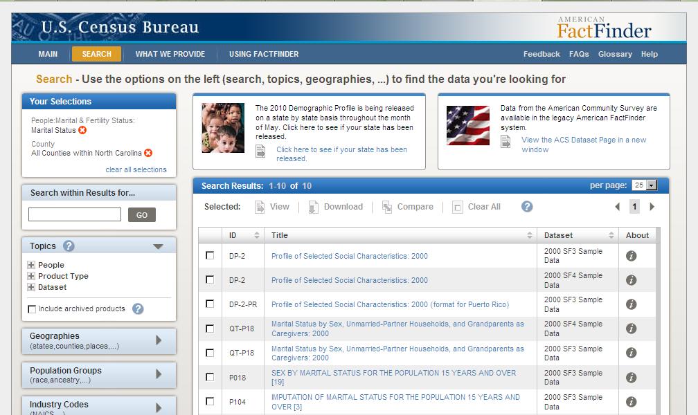
13 Quirky Thing about the Results List Select and Download from this page if you need to pull multiple tables Limit of **10 tables** at a time (I ve asked for an increase in that limit but was told it s a performance issue and anyone wanting more than ten should use the FTP download) Click View if you want to manipulate online

14

15

16

17

18

19
20 Your carpool is leaving N O W W H A T?

21

22

23

24

25

26

27

28

29

30

31

32

33

34

35

36

37

38

39

40
41 Notes You can search for the technical documentation as well as topics in the Quick Start box on the Main page or in the Search within Results for... box on the Search page, but be sure you don t have other geographies or topics selected. You can also link to technical documentation from the i links in the Results list. There is a 250-geography limit on what you pull at once from AFF but a set like, all blocks in a place will count as one geography
42 Other Issues/Enhancements SLOW! Known issue they re working on it In early 2012, plan to add the ability to do basic calculations within the table, e.g., calculate percentages
43 Glossary AFF American FactFinder.csv format comma separated format; readable by many spreadsheet and statistical analysis softwares, including Excel Hayslett GRS webinar, June 9, 2011
44 Other Resources Reference maps ACS - nce_maps/ Decennial m#refmapdesc Hayslett GRS webinar, June 9, 2011
45 For anyone who integrates Census data into GIS In the old AFF, the Excel file download had the concatenated FIPS and the.csv file did not. In the new AFF, the Excel file format is presentationready so GIS users should download the.csv file which in the new AFF has the concatenated FIPS codes.

46 GIS users (courtesy of our GIS librarian) legacy format - to bring this data into ArcGIS you had to delete row 2 shown in blue but that was it.

47 GIS users (courtesy of our GIS librarian) New AFF: you have to move the yellow cells A5, B5 and C5, up to the header row, specifically cells A1, B1, and C1, and then delete rows 2-5 shown in blue Then I usually recommend to people that they create a file geodatabase and import the tables so they can specify the FIPS field as text.
48 Glossary for GIS FIPS code - a numeric identifier that many folks use to join numeric data into GIS files, and there s a separate code for each level of geography, e.g. 037 is the state of North Carolina, 001 is Alamance County. Concatenated FIPS - FIPS codes can repeat across the country there s probably a 001 county in every state. So you have to have the full FIPS code to identify a given geography uniquely: for Alamance, NC instead of the separate codes for state and county. Putting the codes together like that is concatenating, where you preserve leading zeroes and insert no spaces. (And the leading zero is important!) GIS Geographic Information System; thematic mapping
49 Exercise to Try on Your Own Pull a table for all counties in your state that shows veterans by sex and age. Tips: Veteran is a word that describes people. Look for a P table. The most recent data for this will be from See if you can figure out how to apply a filter to find counties with similar numbers of female veterans as your county. Remember you need to transpose rows and columns to get the filter tool. Click the Back to Search button at the top of the page and change your geography from all counties to your city.
50 Answer at least for my location Veterans is a sub-topic under People. After selecting that category, I Searched Within Results for age and sex. Table P039 has what I want. I add the geography filter for all NC counties. I click to View the table, click Modify Table and Transpose Rows & Columns. I see that Orange County has just over 50,000 female veterans, so I click on the filter icon for the Female column and set the Between filter at 50,000 to 51,000. Cabarrus, Orange, Randolph and Rowan have similar populations of female veterans.
51 Answer continued I click on the Back to Search button. I click on the orange X next to All Counties Within North Carolina. I click on the Geography link and in the pop-up window, click on City or Town on the left to limit to that geographic level and then search for my town, Chapel Hill, in the search box. I Add it to my selections and close the pop-up window. My selection of the veterans table was wiped out so I reselected Table P039 and click view. The data are not there. I m thinking this is an issue with what data have been loaded to this point but I m not sure!
Geographical Information Systems Institute. Center for Geographic Analysis, Harvard University
 Geographical Information Systems Institute Center for Geographic Analysis, Harvard University LAB EXERCISE 5: Queries, Joins: Spatial and Non-spatial 1.0 Getting Census data 1. Go to the American Factfinder
Downloading Census Data from American Factfinder2 for use in ArcGIS
 Downloading Census Data from American Factfinder2 for use in ArcGIS Written by Barbara Parmenter, revised November 18, 2011 OBTAINING DATA FROM AMERICAN FACTFINDER2... 1 PREPARING AMERICAN FACTFINDER DATA
Quick Guide to American FactFinder
 Quick Guide to American FactFinder 1. Search Terms... 2 2. Finding Neighborhoods... 6 3. Downloading the Tables 13 4. Interpreting the Numbers... 18 Introduction The American FactFinder is a useful online
Note: you must explicitly follow these instructions to avoid problems
 Exercise 4 Attribute Tables and Census Tract Mapping 30 Points Note: We recommend that you use the Firefox web browser when working with the Census Bureau web site. Objectives: Become familiar with census
Downloading 2010 Census Data
 Downloading 2010 Census Data These instructions cover downloading the Census Tract polygons and the separate attribute data. After that, the attribute data will need additional formatting in Excel before
Downloading Census Data from American Factfinder for use in ArcGIS
 Downloading Census Data from American Factfinder for use in ArcGIS Written by Barbara Parmenter, revised September 24 2013 OBTAINING DATA FROM AMERICAN FACTFINDER (AFF)... 1 PREPARING AMERICAN FACTFINDER
Using American FactFinder
 Using American FactFinder John DeWitt Lisa Neidert Project Manager Data Services Social Science Data Analysis Network Population Studies Center What is American FactFinder? http://factfinder.census.gov
Lab #7: Mapping US Census Data
 Lab #7: Mapping US Census Data Objectives: Access US Census Data via the Web Download census data in excel format Create new variables based on calculations Create key fields for merging with NYC Planning
How to Get Census Data from E-STAT
 How to Get Census Data from E-STAT Connecting to E-STAT 1) From the Library Home Page, http://library.mcmaster.ca, click on the Databases tab 2) Once on the Databases tab, type in estat and hit the Go
The NEW American FactFinder Classroom Training
 2010 The NEW American FactFinder Classroom Training U.S. Census Bureau 10/13/2010 American FactFinder Training Agenda TABLE OF CONTENTS Introduction... 1 Getting Started with American FactFinder... 3
Mapping Tabular Data Display XY points from csv
 Mapping Tabular Data Display XY points from csv Materials needed: AussiePublicToilets.csv. [1] Open and examine the data: Open ArcMap and use the Add Data button to add the table AussiePublicToilets.csv
Consumers Database Instructions: 1. Under 250 Million Consumer Sales Leads, click the orange START button.
 Consumers Database Instructions: 1. Under 250 Million Consumer Sales Leads, click the orange START button. Here you will begin to select your search criteria. With every search you do, you will have to
Working with 2000 Census Data in ArcGIS: Using the US Census Bureau Web Site for SF1 and SF3 Data
 Tufts University GIS Tutorial Working with 2000 Census Data in ArcGIS: Using the US Census Bureau Web Site for SF1 and SF3 Data Revised October 14, 2010 Note: we highly recommend Mozilla Firefox for this
1. Open the New American FactFinder using this link:
 Exercises for Mapping and Using US Census Data MIT GIS Services, IAP 2012 More information, including a comparison of tools available through the MIT Libraries, can be found at: http://libraries.mit.edu/guides/types/census/tools-overview.html
Using the SABINS Data Finder
 Using the SABINS Data Finder August 2011 This guide shows users how to use the School Attendance Boundary Information System (SABINS) to access GIS boundary files and data tables for school attendance
USA Census Tutorial Downloading & Mapping American Factfinder Census Data for use in ArcMap
 USA Census Tutorial Downloading & Mapping American Factfinder Census Data for use in ArcMap Written by Barbara Parmenter, revised by Carolyn Talmadge on September 12, 2017 for ArcMap 10.5.1 Tufts Data
Public Use Microdata Samples
 Public Use Microdata Samples Using PDQ Explore Software Grace York University of Michigan Library December 2003 Public Use Microdata Samples Copies of the original questionnaires with identifying information
Session 3: Cartography in ArcGIS. Mapping population data
 Exercise 3: Cartography in ArcGIS Mapping population data Background GIS is well known for its ability to produce high quality maps. ArcGIS provides useful tools that allow you to do this. It is important
Introduction to Social Explorer
 Introduction to Social Explorer Janine Billadello, Geospatial Data Lab, Baruch College October 1, 2015 Abstract This tutorial will introduce you to Social Explorer, an online mapping interface that allows
Geocoding vs. Add XY Data using Reference USA data in ArcMap
 Geocoding vs. Add XY Data using Reference USA data in ArcMap 10.4.1 Written by Barbara Parmenter. Revised by Carolyn Talmadge 2/27/2017 GETTING BUSINESS DATA FROM REFERENCE USA BY NAICS AND CITY... 2 MODIFY
Census-ACS Master Index Files
 Census-ACS Master Index Files Documentation and User s Guide VERSION 1.1 March 1, 2013 Created by Michael J. Greenwald, Ph.D., AICP With assistance from Jonathan Brooks, Texas A&M Transportation Institute
Creating a Microdata Extract
 Minnesota Population Center Training and Development Creating a Microdata Extract Exercise Objective: Use the IPUMS Terra website to obtain a customized dataset that can be used to answer research questions.
The Data Journalist Chapter 7 tutorial Geocoding in ArcGIS Desktop
 The Data Journalist Chapter 7 tutorial Geocoding in ArcGIS Desktop Summary: In many cases, online geocoding services are all you will need to convert addresses and other location data into geographic data.
Redistricting Data Census P.L Summary File data from the U.S. Census Bureau. NCSL Legislative Summit 2011 San Antonio, TX 08/08/2011
 Redistricting Data 2010 Census P.L. 94-171 Summary File data from the U.S. Census Bureau NCSL Legislative Summit 2011 San Antonio, TX 08/08/2011 Getting Data AFF vs. FTP Obtaining the 2010 Redistricting
Working with International Census Data in GIS
 Working with International Census Data in GIS Updated February 23, 2015 Table of Contents SETTING UP... 1 DATA SOURCES... 1 TABULAR CENSUS DATA... 2 2001 Tabular Census Data... 5 GEOGRAPHIC DATA... 5 JOINING
Development Authority of the North Country (DANC) Internet Mapping Application Instructions Public Viewer 1. Purpose. 2. Logging-in. 3.
 Internet Mapping Application Instructions Public Viewer 1. Purpose. 2. Logging-in. 3.") Development Authority of the North Country (DANC) Internet Mapping Application Instructions Public Viewer 1. Purpose The purpose of this document is to outline basic functionality of the DANC Internet
Development Authority of the North Country (DANC) Internet Mapping Application Instructions Public Viewer 1. Purpose The purpose of this document is to outline basic functionality of the DANC Internet
QGIS LAB SERIES GST 102: Spatial Analysis Lab 2: Introduction to Geospatial Analysis
 QGIS LAB SERIES GST 102: Spatial Analysis Lab 2: Introduction to Geospatial Analysis Objective Understand Attribute Table Joins and Data Classification Document Version: 2014-06-16 (Beta) Contents Introduction...2
Using NHGIS: An Introduction
 Using NHGIS: An Introduction August 2014 Funding provided by the National Science Foundation and National Institutes of Health. Project support provided by the Minnesota Population Center at the University
Converting census data into GIS data
 Converting census data into GIS data For those interested in analyzing Canadian demographics data, census data can be downloaded directly from ODESI or the Canadian Census Analyser. In order to use the
-In windows explorer navigate to your Exercise_4 folder and right-click the DEC_10_SF1_P1.csv file and choose Open With > Notepad.
 BIOL 4460/5460 and GEOL 4460 Introduction to GIS LAB 4 MAKING A THEMATIC MAP This exercise is to show you how to create a map for printing. As you have seen in the lecture, maps can have different purposes
Steve Graves Forensic Geography Lab: Joining Data from Census to GIS. Background
 Steve Graves Forensic Geography Lab: Joining Data from Census to GIS Background Now that you have some experience downloading Census Data from the internet, you must now learn to make it appear on a map
Solar Campaign Google Guide. PART 1 Google Drive
 Solar Campaign Google Guide This guide assumes your team has already retrieved its template Solar Campaign folder from Vital Communities and shared it with the entire volunteer team on Google Drive. To
WOMEN'S INTERAGENCY HIV STUDY SECTION 40: GEOCODING PROTOCOL
 WOMEN'S INTERAGENCY HIV STUDY SECTION 40: GEOCODING PROTOCOL A. BACKGROUND & STUDY PURPOSE This study will investigate how socioeconomic context and health care coverage contribute to health outcomes among
Public Use Microdata Samples
 Public Use Microdata Samples Using PDQ Explore Software Grace York University of Michigan Library May 2004 2000 Census Data Tabulations Summary Files 1-4, Equal Employment Opportunity, School District
Geography 281 Map Making with GIS Project Three: Viewing Data Spatially
 Geography 281 Map Making with GIS Project Three: Viewing Data Spatially This activity introduces three of the most common thematic maps: Choropleth maps Dot density maps Graduated symbol maps You will
Exercise 1: An Overview of ArcMap and ArcCatalog
 Exercise 1: An Overview of ArcMap and ArcCatalog Introduction: ArcGIS is an integrated collection of GIS software products for building a complete GIS. ArcGIS enables users to deploy GIS functionality
ACS Summary File Technical Documentation
 ACS Summary File Technical Documentation 2015 ACS 1-year and 2011-2015 ACS 5-year Data Releases American Community Survey Office Issued September 2016 Table of Contents 1 INTRODUCTION... 1 1.1 THE AMERICAN
Georeferencing Tutorials and Recommended Practices
 March 21, 2008 Georeferencing Tutorials and Recommended Practices Topic Page Introduction 1 Preparing address data for georefernecing 1 Available address geocoders, pros and cons 1 Using Batchgeocode.com
Creating a reference map
 Chapter 1 Creating a reference map Reference maps are basic, traditional maps. Their purpose is to illustrate geographic boundaries for cities, counties, and other areas. Reference maps have no underlying
 Example 1 - Joining datasets by a common variable: Creating a single table using multiple datasets Other features illustrated: Aggregate data multi-variable recode, computational calculation Background:
Geodatabases. Dr. Zhang SPRING 2016 GISC /03/2016
 Geodatabases Dr. Zhang SPRING 2016 GISC 1401 10/03/2016 Using and making maps Navigating GIS maps Map design Working with spatial data Spatial data infrastructure Interactive maps Map Animations Map layouts
Visual Studies Exercise.Topic08 (Architectural Paleontology) Geographic Information Systems (GIS), Part I
 Geographic Information Systems (GIS), Part I") ARCH1291 Visual Studies II Week 8, Spring 2013 Assignment 7 GIS I Prof. Alihan Polat Visual Studies Exercise.Topic08 (Architectural Paleontology) Geographic Information Systems (GIS), Part I Medium: GIS
ARCH1291 Visual Studies II Week 8, Spring 2013 Assignment 7 GIS I Prof. Alihan Polat Visual Studies Exercise.Topic08 (Architectural Paleontology) Geographic Information Systems (GIS), Part I Medium: GIS
Instructions: DRDP Online Child Upload
 Instructions: DRDP Online Child Upload Version 1.00 10/29/2018 Table of Contents Introduction... 2 Upload Roles... 2 Upload Template... 2 Entering Data into the Template... 3 Uploading to DRDP Online...
Getting Started with ArcGIS Background and Introduction
 Getting Started with ArcGIS Background and Introduction BACKGROUND ON ArcGIS SOFTWARE ArcGIS is a set of tools for collecting, storing, managing, analyzing, and representing geographic information. It
Mapping Census data in QGIS
 Mapping Census data in QGIS Contents Contents 1. Introduction...3 1.1. Census data...3 1.2. Boundary data...3 1.3. Mapping software...3 2. Obtain your census data...4 Step 1: Geography...4 Step 2: Topics...5
Section 2: Downloading and Processing Data
 Downloading and Processing Data Joining Data Tables 2.1.1 Section 2: Downloading and Processing Data 2.1 Joining Data Tables Many times you will find a table of data that you want to map, perhaps as an
Downloading shapefiles and using essential ArcMap tools
 CHAPTER 1 KEY CONCEPTS downloading shapefiles learning essential tools exploring the ArcMap table of contents understanding shapefiles customizing shapefiles saving projects Downloading shapefiles and
Access Data with Census APIs
 You are here: Census.gov APIs - US Census Bureau Access Data with Census APIs Census Bureau APIs To improve access to data and encourage innovation, the Census Bureau has begun to provide API access to
POLIDATA Political Data Analysis DATABASE DEVELOPMENT, ANALYSIS AND PUBLICATION; POLITICAL AND CENSUS DATA; LITIGATION SUPPORT
 POLIDATA Political Data Analysis DATABASE DEVELOPMENT, ANALYSIS AND PUBLICATION; POLITICAL AND CENSUS DATA; LITIGATION SUPPORT CLARK BENSEN POLIDATA 1303 HAYWARD ROAD, P. O. BOX 530 CORINTH, VT 05039 Tel:
GEOL 452/552 - GIS for Geoscientists I
 GEOL 452/552 - GIS for Geoscientists I Lecture 8 Chapter 4 - Attribute Data Today Chapter 4: Attribute Data Tables (general, import formats, field types), Selecting, SQL Query, Statistics, field calculator,
SAS Web Report Studio 3.1
 SAS Web Report Studio 3.1 User s Guide SAS Documentation The correct bibliographic citation for this manual is as follows: SAS Institute Inc. 2006. SAS Web Report Studio 3.1: User s Guide. Cary, NC: SAS
Quick Reference for the FloridaCHARTS Fetal Death Query
 Quick Reference for the FloridaCHARTS Fetal Death Query 1. Toolbar Functions 2. Reports 3. Frequently Asked Questions This application is set up in sections. To use it, you do not have to follow any particular
Welcome to Cole On-line Help system!
 Welcome to Cole On-line Help system! Cole Online is an Internet based information directory that allows fast and efficient access to demographic information about residences and businesses. You can search
Know Your Community: Using Demographic Data to Inform Planning
 Know Your Community: Using Demographic Data to Inform Planning DENISE M. DAVIS RIPL 2016 1 What will be covered Overview of national data available to support community level awareness, national public
Filter and PivotTables in Excel
 Filter and PivotTables in Excel FILTERING With filters in Excel you can quickly collapse your spreadsheet to find records meeting specific criteria. A lot of reporters use filter to cut their data down
Workshop: Qualitative Data Analysis with Atlas.ti
 Workshop: Qualitative Data Analysis with Atlas.ti December 2017 D-Lab Follow-Along (dlab.berkeley.edu) Celia Emmelhainz, Qualitative Research Librarian, UC Berkeley Today s outline: Introductions and overview
Steps and Strokes. Please go to the Census Bureau home page:
 An Example of Using American Community Survey Data and the Downloading of Data from the Census Bureau s Website to Determine the Significance of Economic Change in Several States, Several Metropolitan
Figure 3.20: Visualize the Titanic Dataset
 80 Chapter 3. Data Mining with Azure Machine Learning Studio Figure 3.20: Visualize the Titanic Dataset 3. After verifying the output, we will cast categorical values to the corresponding columns. To begin,
MAPLOGIC CORPORATION. GIS Software Solutions. Getting Started. With MapLogic Layout Manager
 MAPLOGIC CORPORATION GIS Software Solutions Getting Started With MapLogic Layout Manager Getting Started with MapLogic Layout Manager 2011 MapLogic Corporation All Rights Reserved 330 West Canton Ave.,
Geocoding Reference USA data in ArcMap 10.1
 Geocoding Reference USA data in ArcMap 10.1 Written by Barbara Parmenter, revised 2/21/2014 GETTING BUSINESS DATA FROM REFERENCE USA BY NAICS AND CITY... 2 MODIFY YOUR EXCEL FILE... 5 STARTING ARCMAP...
Tutorial 4 - Attribute data in ArcGIS
 Tutorial 4 - Attribute data in ArcGIS COPY the Lab4 archive to your server folder and unpack it. The objectives of this tutorial include: Understand how ArcGIS stores and structures attribute data Learn
Registered User Insurance Instructions for Domestic Travel with Student Clubs/Organizations
 Registered User Insurance Instructions for Domestic Travel with Student Clubs/Organizations 1. Go to: http://www.adventistrisk.org/insurance/trave linsurance.aspx. 2. Type in your User Name and Password
Map Direct Lite. Quick Start Guide: Search Results 05/14/2018
 Map Direct Lite Quick Start Guide: Search Results 05/14/2018 Contents Quick Start Guide: Search Results... 1 Search Results in Map Direct Lite.... 2 Where is the Search Results Panel?... 3 Search Result
screen. You should save
 How to use the Florida Senate DistrictBuilder software for local redistricting Log on to http://www.flsenate.gov/session/redistricting/, select District Builder, and request an account. This will only
Introduction to GIS & Mapping: ArcGIS Desktop
 Introduction to GIS & Mapping: ArcGIS Desktop Your task in this exercise is to determine the best place to build a mixed use facility in Hudson County, NJ. In order to revitalize the community and take
Information for Bulk Users
 2011 Census: Customer Support Information for Bulk Users December 2012 You could use this area to talk about services from Census Customer Services, and any other guides or instructions available. If you
Making Charts with Infogram
 Making Charts with Infogram In this lesson, you will learn how to make several basic interactive charts with an online tool called Infogram. First, download and open the Excel file infographics_data.xlsx.
GIS Basics for Urban Studies
 GIS Basics for Urban Studies Date: March 21, 2018 Contacts: Mehdi Aminipouri, Graduate Peer GIS Faciliator, SFU Library (maminipo@sfu.ca) Keshav Mukunda, GIS & Map Librarian Librarian for Geography (kmukunda@sfu.ca)
Geography 281 Mapmaking with GIS Project One: Exploring the ArcMap Environment
 Geography 281 Mapmaking with GIS Project One: Exploring the ArcMap Environment This activity is designed to introduce you to the Geography Lab and to the ArcMap software within the lab environment. Before
Note: For more information on creating labels in CDS, watch Volume 22 of the Fast Class Update: Label Creation.
 Information used to create labels the Client Data System (CDS) can be exported out of CDS and used to create labels in Microsoft Word. In Word, you can make changes to the style, size, and color of fonts
Concatenate Function Page 505
 Concatenate Function Page 505 The Concatenate Function is used to tie together different text strings. It is useful, for example, if you have columns in your Excel workbook for First Name and Last Name
Exercise Producing Thematic Maps for Dissemination
 Exercise Producing Thematic Maps for Dissemination 2007 In this exercise you will work with an existing file geodatabase which contains administrative boundaries (named wards) feature class and population
Geography 281 Mapmaking with GIS Project One: Exploring the ArcMap Environment
 Geography 281 Mapmaking with GIS Project One: Exploring the ArcMap Environment This activity is designed to introduce you to the Geography Lab and to the ArcMap software within the lab environment. Please
HOW TO GENERATE AND UNDERSTAND THE UPLOAD LOG REPORT
 Florida SHOTS HOW TO GENERATE AND UNDERSTAND THE UPLOAD LOG REPORT www.flshots.com Data Upload Log Review: The main reason to generate an upload log report is to ensure that data is being uploaded to Florida
GPS TO GIS EXERCISE (30 PTS)
") GPS TO GIS EXERCISE (30 PTS) This exercise will allow you to demonstrate your cumulative knowledge of using a GPS receiver to collect data with locational information, downloading this data to a desktop
GPS TO GIS EXERCISE (30 PTS) This exercise will allow you to demonstrate your cumulative knowledge of using a GPS receiver to collect data with locational information, downloading this data to a desktop
Workshop. Import Workshop
 Import Overview This workshop will help participants understand the tools and techniques used in importing a variety of different types of data. It will also showcase a couple of the new import features
GEO 425: SPRING 2012 LAB 10: Intermediate Postgresql and SQL
 GEO 425: SPRING 2012 LAB 10: Intermediate Postgresql and SQL Objectives: In the introductory SQL lab you worked with basic queries on two tables. This lab builds on that one by providing more advanced
Excel Foundation Quick Reference (Windows PC)
") Excel Foundation Quick Reference (Windows PC) See https://staff.brighton.ac.uk/is/training/pages/excel/foundation.aspx for videos and exercises to accompany this quick reference card. Structure of a spreadsheet
Excel Foundation Quick Reference (Windows PC) See https://staff.brighton.ac.uk/is/training/pages/excel/foundation.aspx for videos and exercises to accompany this quick reference card. Structure of a spreadsheet
emerge Help Document Table of Contents
 Table of Contents Logging Into emerge... 2 Navigation Bar... 3 Main Menu... 4 Creating a New Order... 6 Order Checklist... 6 Information... 7 Overview... 8 Geography... 9 List Select... 12 Demographics...
emerge Help Document Table of Contents
 Table of Contents Logging Into emerge... 2 Navigation Bar... 3 Main Menu... 4 My Account... 6 My Information... 6 Manage Lists... 7 Manage Seeds... 8 Search/Add Suppress... 9 Update My Suppress... 10 Creating
Intro to GIS (requirements: basic Windows computer skills and a flash drive)
") Introduction to GIS Intro to GIS (requirements: basic Windows computer skills and a flash drive) Part 1. What is GIS. 1. System: hardware (computers, devices), software (proprietary or free), people. 2.
Introduction to GIS Intro to GIS (requirements: basic Windows computer skills and a flash drive) Part 1. What is GIS. 1. System: hardware (computers, devices), software (proprietary or free), people. 2.
Mapping Tabular Data
 Mapping Tabular Data ArcGIS Desktop 10.1 Instructional Guide Kim Ricker GIS/Data Center Head (713) 348-5691 Jean Niswonger GIS Support Specialist (713) 348-2595 This guide was created by the staff of the
University of North Dakota PeopleSoft Finance Tip Sheets. Utilizing the Query Download Feature
 There is a custom feature available in Query Viewer that allows files to be created from queries and copied to a user s PC. This feature doesn t have the same size limitations as running a query to HTML
How to calculate population and jobs within ½ mile radius of site
 How to calculate population and jobs within ½ mile radius of site Caltrans Project P359, Trip Generation Rates for Transportation Impact Analyses of Smart Growth Land Use Projects SECTION PAGE Population
USING 2001 CENSUS DATA IN ArcMap 8.2
 USING 2001 CENSUS DATA IN ArcMap 8.2 This is a guide to mapping 2001 Census data in ArcMap using age and sex profile data for Toronto at the census tract level. Importing boundary files, importing census
Overview of the EMF Refresher Webinar Series. EMF Resources
 Overview of the EMF Refresher Webinar Series Introduction to the EMF Working with Data in the EMF viewing & editing Inventory Data Analysis and Reporting 1 EMF User's Guide EMF Resources http://www.cmascenter.org/emf/internal/guide.html
Geocoding Reference USA data in ArcMap 9.3
 Tufts GIS Tip Sheet Geocoding Reference USA data in ArcMap 9.3 Written by Barbara Parmenter Revised 3/1/2011 In this exercise, you will map businesses or services for a town in the Boston metropolitan
Excel Tools for Internal Auditing
 Excel Tools for Internal Auditing BONNIE MAXFIELD SMITH COUNTY INTERNAL AUDITOR Data Process Obtain Data Data Import Format Text to Columns Concatenate Macros Compare /Analyze IF Function Subtotal Random
LEIAG-Excel Workshop
 Random Sample Excel has a simple formula we can utilize to obtain a random sample (cases, citations, city, etc.) At the Sheriff s Department, we are able to run a case management report that generates
Welcome / Introductions
 A23 - CECAS Analytics Tool I Training Script (11.12.2014) 1 Welcome / Introductions Hello. I m Patricia Smith, regional trainer for regions 5 and 7. I d like to welcome you to this CECAS Analytics Tool
GIS Virtual Workshop: Geocoding
 This module will deal with the concept of geocoding of data. Geocoding is placing a data point which does not have a X, Y reference (no Latitude and Longitude) and automatically mapping it by knowing the
Ryerson University, March Table of Contents. Joining CHASS Data To ArcView Cartographic Files A. Importing An Arc Export File...
 Ryerson University, March 2001 Table of Contents Joining CHASS Data To ArcView Cartographic Files... -1 A. Importing An Arc Export File... -1 B. Opening The Arc/Info Coverage In ArcView... -2 C. Converting
YGL 3.0 // The Basics
 YGL 3.0 // The Basics Thank you for your continued support of You ve Got Leads! The following document is intended to help with the many features of the program. Each community may have different features
Using Spatial Data in a Desktop GIS; QGIS 2.8 Practical 2
 Using Spatial Data in a Desktop GIS; QGIS 2.8 Practical 2 Practical 2 Learning objectives: To work with a vector base map within a GIS and overlay point data. To practise using Ordnance Survey mapping
Census Small Area Population Statistics (SAPS) A Guide to using the SAPMAP web application
 A Guide to using the SAPMAP web application") Census Small Area Population Statistics (SAPS) A Guide to using the SAPMAP web application 1 When you open the application you will see this page. This screen gives a brief description of the application.
Census Small Area Population Statistics (SAPS) A Guide to using the SAPMAP web application 1 When you open the application you will see this page. This screen gives a brief description of the application.
EXCELLING WITH ANALYSIS AND VISUALIZATION
 EXCELLING WITH ANALYSIS AND VISUALIZATION A PRACTICAL GUIDE FOR DEALING WITH DATA Prepared by Ann K. Emery July 2016 Ann K. Emery 1 Welcome Hello there! In July 2016, I led two workshops Excel Basics for
A Populous Place State Pie Chart
 A Populous Place State Pie Chart Step 1 Start Microsoft Excel and a blank workbook will open. Step 2 Click in cell C1 once to highlight the cell and change the font to 24- point. You can use the pull-down
User Manual. perfectionlearning.com/technical-support
 User Manual perfectionlearning.com/technical-support 1 User Manual Accessing Math X... 3 Login... 3 Forgotten Password... 3 Navigation Menu... 4 Logout... 4 Admin... 5 Creating Classes and Students...
Choropleth Mapping with GIS
 Choropleth Mapping with GIS In this lab you will be making 4 choropleth maps of the data you downloaded and processed last week. You will make your maps in ArcGIS using three different methods of classing
PDQ-Notes. Reynolds Farley. PDQ-Note 3 Displaying Your Results in the Expert Query Window
 PDQ-Notes Reynolds Farley PDQ-Note 3 Displaying Your Results in the Expert Query Window PDQ-Note 3 Displaying Your Results in the Expert Query Window Most of your options for configuring your query results