Ocean, Atmosphere & Climate Model Assessment for Everyone
|
|
|
- Claud Doyle
- 6 years ago
- Views:
Transcription


1 Ocean, Atmosphere & Climate Model Assessment for Everyone Rich Signell USGS Woods Hole, MA Unidata 2014 DeSouza Award Presentation Boulder, CO : Sep 15, 2014
2 2


3 US Integrated Ocean Observing System (IOOS ) IOOS Plan defines: Global Component Coastal Component 17 Federal Agencies 11 Regional Associations


4 How well do models simulate events? Hurricane Sandy, Ocean Grove Pier - New Jersey, October 29, Photograph by Bob Bowné Deepwater Horizon Oil Spill, Northern Gulf of Mexico, May 24, Image from MODIS on NASA s Terra Satellite. 4


5 IOOS Core Principles Adopt open standards & practices Avoid customer-specific stovepipes Standardized access services implemented at data providers Observations Models Data Provider Web access service Customer 5

6 Issue: Ocean grids are not regularly spaced! Curvilinear orthogonal horizontal coordinates Stretched surface and terrain following vertical coordinates
 grid")
7 Unstructured (e.g. triangular) grid


8 Time Series, Trajectories Meteorology and Wave Buoy in the Gulf of Maine. Image courtesy of NOAA. Ocean Glider. Photo by Dave Fratantoni, Woods Hole Oceanographic Institution

9 NetCDF Climate and Forecast (CF) Conventions provide a solution Groups using CF: GO-ESSP: Global Organization for Earth System Science Portal IOOS: Integrated Ocean Observing System ESMF: Earth System Modeling Framework OGC: Open Geospatial Consortium (GALEON: WCS profile)
10 UGRID Conventions on GitHub

11 Example NcML (on StackOverflow)
12 IOOS Model Data Interoperability Design Nonstandard Model Output Data Files ROMS NCOM HYCOM SELFE ADCIRC FVCOM Standardized (CF-1.6, UGRID-0.9) Virtual Datasets NcML NcML NcML NcML NcML NcML THREDDS Data Server NetCDF-Java Common Data Model Grid Ugrid TimeSeries Profile Trajectory TimeSeriesProfile Web Services OPeNDAP+CF WCS SOS WMS NetCDF Subset nciso Library or Broker NetCDF -Java NetCDF4 -Python ERDDAP CKAN/pyCSW Clients Matlab IDV Panoply ArcGIS Python Godiva2 Observed data (buoy, gauge, ADCP, glider) Nonstandard Data Files Catalog Services Geoportal Server GeoNetwork GI-CAT

13 WMS Browsing with THREDDS/ncWMS

![geo]=nj_tslice(url, temp,1); t = 22x120x180 single geo = lat: [120x180 single] lon: [120x180](/docs-images/78/77239532/images/14-3.jpg "single] z: [22x120x180 double] time: 733582 (matlab datenum) nj_tslice works identically for ROMS,")
14 Matlab NCTOOLBOX Objective: Make it simple to access CF data Example function: [t, geo]=nj_tslice(url, temp,1); t = 22x120x180 single geo = lat: [120x180 single] lon: [120x180 single] z: [22x120x180 double] time: (matlab datenum) nj_tslice works identically for ROMS, POM, ECOM, WRF, Wavewatch3 URL can be: local NetCDF, remote NetCDF, NcML, OpenDAP Data URL
 ncvar = nc.")
 z = 26441x1 single grid = lat: [26441x1 single] lon:")
15 Matlab NCTOOLBOX nc = ncugrid(dap_url) ncvar = nc.uvariable( zeta ) z = ncvar.data(itime,:) grid = ncvar.grid(itime,:) z = 26441x1 single grid = lat: [26441x1 single] lon: [26441x1 single] time: (matlab datenum) connectivity: [52025x3 int32]
16 Comparing Models with Data in Matlab Model 1: UMASS-ECOM Model 2: UMAINE-POM Data: SST 2008-Sep-08 07:32

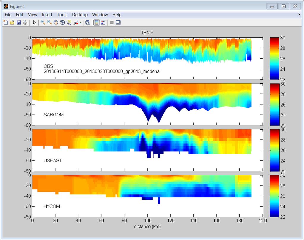
17 Skidaway modena glider (Sep 11-23)
18 compare_secoora_model_sections.m (using nc_genslice.m)
19
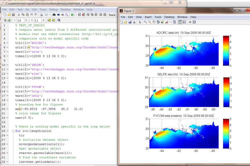
20 test_cf_ugrid3.m

21 3D visualization of data with IDV
22 NetCDF Subset Service to CSV
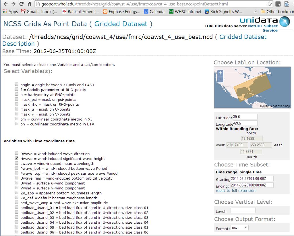
23
24 CSV Time Series from Subset Service CSV request is a RESTful URL: =Hwave&latitude=39.5&longitude=-69.5&time_start= T01:00:00Z&time_end= T00:00:00Z&vertCoord=&accept=csv

25 Accessing the CSV data in Excel
26 Access the CSV data in Python, R, etc

27 Iris Python tools from the UK Met Office
28 ESPreSSO model (Rutgers)
29 Global RTOFS (NOAA)
30 IOOS Models Notebook on Wakari
31 60 minutes to serving your data 1. Install Sun/Oracle Java (10 min) 2. Install/configure Tomcat (15 min) 3. Install/configure the Thredds Data Server (15 min) 4. Put NetCDF (or HDF4, Grib1, Grib2, HDF5 files) in a directory (5 min) 5. Add NcML (XML) files for CF compliance and aggregation (15 min)
32 Adding data to THREDDS ls *wide* his_bbleh_wide_0048.nc his_bbleh_wide_0100.nc his_bbleh_wide_0152.nc his_bbleh_wide_0049.nc his_bbleh_wide_0101.nc his_bbleh_wide_0153.nc his_bbleh_wide_0050.nc his_bbleh_wide_0102.nc his_bbleh_wide_0154.nc his_bbleh_wide_0051.nc his_bbleh_wide_0103.nc wide.ncml $more wide.ncml <netcdf xmlns=" <aggregation dimname="ocean_time" type="joinexisting"> <scan location="." regexp=".*wide.*_[0-9]{4}\.nc$"/> </aggregation> </netcdf>
33

34 Browsing WMS with Godiva2

35 Searching for Data GI-CAT catalog broker service architecture
36
37 IOOS System Test Project Lead: Derrick Snowden Notebooks: Kyle Wilcox, Andy Bird, Bob Fratantonio, Kelly Knee, Will Koeppen, Hannah Dean
38
39 Automated model comparison

40 SECOORA Model Assessment Nbviewer link
41 Project Lead: Vembu Subramanian Notebook: Filipe Fernandes URL:
42 Python & Matlab notebook
 IDV-like client built on top of Python tools Participation in standards (e.g. OGC) Managing community development")
43 Unidata Challenges Community THREDDS Data Servers robustness Support as popularity increases UGRID incorporated into Unidata NetCDF-Java Aggregation of large collections of NetCDF files Met/Ocean tools developed for Python on top of CF/Ugrid conventions (Iris, libcf) IDV-like client built on top of Python tools Participation in standards (e.g. OGC) Managing community development
44 Community Development
45 Community Development

46 Why do I promote Unidata technologies? Powerful Flexible Easy to install Free Supported Driven by community of users 46

47

48

49

50
51
52 Summary (1 of 2) Common data models for feature types (structured and unstructured grids, time series, profiles, swaths) (Unidata CDM) Standard web services for delivering these data and metadata (OGC, Unidata) Tools to access and process these services in common analysis environments: R, Matlab, Python, ArcGIS, JavaScript

53 Summary (2 of 2) It s easy (1 hour) to deploy free, supported systems that allow for standards-based delivery of aggregated data from native model grids that put little effort on the data provider What do you get? Lots of choices for data access (Browser, Matlab, Python, Excel, IDV, R, IDL) More usage of model results by more people Faster feedback to modelers, leading to improved models Shared code base in the community Increased community support for standards-based access Less time wasted messing with data, more time spent on ecosystem based management What should you do? Encourage providers to use these standards, and develop tools that use standardized access
54 More at: Github.com/rsignell-usgs
Catalog-driven, Reproducible Workflows for Ocean Science
 Catalog-driven, Reproducible Workflows for Ocean Science Rich Signell, USGS, Woods Hole, MA, USA Filipe Fernandes, Centro Universidade Monte Serrat, Santos, Brazil. 2015 Boston Light Swim, Aug 15, 7:00am
Uniform Resource Locator Wide Area Network World Climate Research Programme Coupled Model Intercomparison
 Glossary API Application Programming Interface AR5 IPCC Assessment Report 4 ASCII American Standard Code for Information Interchange BUFR Binary Universal Form for the Representation of meteorological
Making data access easier with OPeNDAP. James Gallapher (OPeNDAP TM ) Duan Beckett (BoM) Kate Snow (NCI) Robert Davy (CSIRO) Adrian Burton (ARDC)
 Duan Beckett (BoM) Kate Snow (NCI) Robert Davy (CSIRO) Adrian Burton (ARDC)") Making data access easier with OPeNDAP James Gallapher (OPeNDAP TM ) Duan Beckett (BoM) Kate Snow (NCI) Robert Davy (CSIRO) Adrian Burton (ARDC) Outline Introduction and trajectory (James Gallapher) OPeNDAP
Making data access easier with OPeNDAP James Gallapher (OPeNDAP TM ) Duan Beckett (BoM) Kate Snow (NCI) Robert Davy (CSIRO) Adrian Burton (ARDC) Outline Introduction and trajectory (James Gallapher) OPeNDAP
Using the Network Common Data Form for storage of atmospheric data
 Using the Network Common Data Form for storage of atmospheric data Maarten Plieger Royal Netherlands Meteorological Institute The NetCDF4 data format (Network Common Data Form) is used within the ADAGUC
Desarrollo de una herramienta de visualización de datos oceanográficos: Modelos y Observaciones
 Desarrollo de una herramienta de visualización de datos oceanográficos: Modelos y Observaciones J. Fernandez, J. Lopez, I. Carlos, F. Jerez, F. Hermosilla, M. Espino SIMO, LIM-UPC, CIIRC FIELD_AC 7 th
Online intercomparison of models and observations using OGC and community standards
 Online intercomparison of models and observations using OGC and community standards Alastair Gemmell * Jon Blower Keith Haines Adit Santokhee Reading e-science e Centre, Environmental Systems Science Centre,
Data Centre NetCDF Implementation Pilot
 Data Centre NetCDF Implementation Pilot Peter Miu EUMETSAT User Conference Oslo, Sep. 2011 Splinter Session, Facilitating Data Access and Utilisation Slide: 1 EUM/OPS/VWG/11/2600 V.1 What is this Pilot
OPeNDAP: Accessing HYCOM (and other data) remotely
 remotely") OPeNDAP: Accessing HYCOM (and other data) remotely Presented at The HYCOM NOPP GODAE Meeting By Peter Cornillon OPeNDAP Inc., Narragansett, RI 02882 7 December 2005 8/25/05 HYCOM NOPP GODAE 1 Acknowledgements
OPeNDAP: Accessing HYCOM (and other data) remotely Presented at The HYCOM NOPP GODAE Meeting By Peter Cornillon OPeNDAP Inc., Narragansett, RI 02882 7 December 2005 8/25/05 HYCOM NOPP GODAE 1 Acknowledgements
New Datasets, Functionality and Future Development. Ashwanth Srinivasan, (FSU) Steve Hankin (NOAA/PMEL) Major contributors: Jon Callahan (Mazama(
 Steve Hankin (NOAA/PMEL) Major contributors: Jon Callahan (Mazama(") HYCOM Data Service New Datasets, Functionality and Future Development Ashwanth Srinivasan, (FSU) Steve Hankin (NOAA/PMEL) Major contributors: Jon Callahan (Mazama( Consulting) Roland Schweitzer (Weathertop
HYCOM Data Service New Datasets, Functionality and Future Development Ashwanth Srinivasan, (FSU) Steve Hankin (NOAA/PMEL) Major contributors: Jon Callahan (Mazama( Consulting) Roland Schweitzer (Weathertop
THREDDS and the THREDDS Data Server (TDS) Don Murray CU/CIRES Slides by Ethan Davis - Unidata
 Don Murray CU/CIRES Slides by Ethan Davis - Unidata") THREDDS and the THREDDS Data Server (TDS) Don Murray CU/CIRES Slides by Ethan Davis - Unidata THREDDS Data Server (TDS) Web server for scienmfic data (wripen in 100% Java) Can serve any dataset the netcdf-
THREDDS and the THREDDS Data Server (TDS) Don Murray CU/CIRES Slides by Ethan Davis - Unidata THREDDS Data Server (TDS) Web server for scienmfic data (wripen in 100% Java) Can serve any dataset the netcdf-
CF-netCDF and CDM. Ethan Davis, John Caron, Ben Domenico, Stefano Nativi* UCAR Unidata Univ of Florence*
 CF-netCDF and CDM Ethan Davis, John Caron, Ben Domenico, Stefano Nativi* UCAR Unidata Univ of Florence* OGC in MetOcean, Toulouse, France, November 2009 CF-netCDF and CDM CF-netCDF CDM/netCDF-java TDS
NetCDF and Related Interna/onal Standards
 NetCDF and Related Interna/onal Standards Ben Domenico October 2012 Outline Brief historical context Unidata/partners have established a solid founda/on: Standard data access interfaces enable other Earth
NetCDF and HDF5. NASA Earth Science Data Systems Working Group October 20, 2010 New Orleans. Ed Hartnett, Unidata/UCAR, 2010
 NetCDF and HDF5 NASA Earth Science Data Systems Working Group October 20, 2010 New Orleans Ed Hartnett, Unidata/UCAR, 2010 Unidata Mission: To provide the data services, tools, and cyberinfrastructure
HDF Product Designer: A tool for building HDF5 containers with granule metadata
 The HDF Group HDF Product Designer: A tool for building HDF5 containers with granule metadata Lindsay Powers Aleksandar Jelenak, Joe Lee, Ted Habermann The HDF Group Data Producer s Conundrum 2 HDF Features
Distributed Online Data Access and Analysis
 Distributed Online Data Access and Analysis Ruixin Yang George Mason University Slides from SIESIP Partners and from NOMADS PI, Glenn K. Rutledge of US NCDC on NOMADS SIESIP: Seasonal-to-Interannual Earth
Oceanic Observatory for the Iberian Shelf
 Oceanic Observatory for the Iberian Shelf B.Vila Barcelona, 26th September 2016 Objectives: The Project Improve the oceanic observation at the North Western Iberian coast (meteorological, oceanographical
The GEO Discovery and Access Broker
 WGISS-43 The GEO Discovery and Access Broker S. Nativi (1), M. Santoro (1) (1) Institute of Atmospheric Pollution Research, National Research Council of Italy DOWNSTREAM MIDSTREAM end-users Applications
HYCOM Data Service and Web Outreach
 HYCOM Data Service and Web Outreach A. Srinivasan 1, S. Hankin, P. Cornillon, and E. P. Chassignet 1 Center for Ocean-Atmospheric Prediction Studies, Florida State University phone: (850) 644-7462 fax:
The NCAR Community Data Portal
 The NCAR Community Data Portal http://cdp.ucar.edu/ QuickTime and a TIFF (Uncompressed) decompressor are needed to see this picture. QuickTime and a TIFF (Uncompressed) decompressor are needed to see this
Python: Working with Multidimensional Scientific Data. Nawajish Noman Deng Ding
 Python: Working with Multidimensional Scientific Data Nawajish Noman Deng Ding Outline Scientific Multidimensional Data Ingest and Data Management Analysis and Visualization Extending Analytical Capabilities
Steve Ansari *, Stephen Del Greco, Neal Lott NOAA National Climatic Data Center, Asheville, North Carolina 2. DATA
 5A.1 THE WEATHER AND CLIMATE TOOLKIT Steve Ansari *, Stephen Del Greco, Neal Lott NOAA National Climatic Data Center, Asheville, North Carolina ABSTRACT The Weather and Climate Toolkit (WCT) is free, platform
And now for something completely different
 And now for something completely different (data management?) HYCOM Data Management & Services Ashwanth Srinivasan (RSMAS) Steve Hankin (PMEL) A community of of contributors, including Peter Peter Cornillon,
OGC at KNMI: Current use and plans
 OGC at KNMI: Current use and plans 4th Workshop on the use of GIS/OGC standards in meteorology 4 th of March 2013, Reading 1. Ernst de Vreede 2. Maarten Plieger Contents 1. ADAGUC 2. Internal applications
THE GEOSS PLATFORM TOWARDS A BIG EO DATA SYSTEM LINKING GLOBAL USERS AND DATA PROVIDERS
 THE PLATFORM TOWARDS A BIG EO DATA SYSTEM LINKING GLOBAL USERS AND DATA PROVIDERS J. Van Bemmelen (1), P. De Salvo (2), M. Santoro (3), P. Mazzetti (3), G. Colangeli (1), S. Nativi (4) (1) European Space
NetCDF-4: : Software Implementing an Enhanced Data Model for the Geosciences
 NetCDF-4: : Software Implementing an Enhanced Data Model for the Geosciences Russ Rew, Ed Hartnett, and John Caron UCAR Unidata Program, Boulder 2006-01-31 Acknowledgments This work was supported by the
PARR for the Course: GIS and Public Access to NOAA Fisheries Research Data
 PARR for the Course: GIS and Public Access to NOAA Fisheries Research Data Tiffany C. Vance and Nazila Merati NOAA/NMFS/Alaska Fisheries Science Center Public Access to Research Results (PARR) Publications
IMOS/AODN ocean portal: tools for data delivery. Roger Proctor, Peter Blain, Sebastien Mancini IMOS
 IMOS/AODN ocean portal: tools for data delivery Roger Proctor, Peter Blain, Sebastien Mancini IMOS Data from IMOS: The six Nodes Bluewater and Climate Node open ocean focus Five Regional Nodes continental
Air Quality Community Experiences and Perspectives on International Interoperability Standards
 Air Quality Community Experiences and Perspectives on International Interoperability Standards Erin Robinson, Stefan Falke, Rudolf Husar, David McCabe, Frank Lindsay, Chris Lynnes, Greg Leptoukh, Beate
The Many Facets of THREDDS Thematic Real-time Environmental Distributed Data Services
 The Many Facets of THREDDS Thematic Real-time Environmental Distributed Data Services For March 2007 Unidata Policy Committee Meeting Ben Domenico 1 Motivation From the Unidata 2003 proposal: utilizing
NetCDF and Scientific Data Durability. Russ Rew, UCAR Unidata ESIP Federation Summer Meeting
 NetCDF and Scientific Data Durability Russ Rew, UCAR Unidata ESIP Federation Summer Meeting 2009-07-08 For preserving data, is format obsolescence a non-issue? Why do formats (and their access software)
Unidata and data-proximate analysis and visualization in the cloud
 Unidata and data-proximate analysis and visualization in the cloud Mohan Ramamurthy and Many Unidata Staff 1 June 2017 Modeling in the Cloud Workshop Unidata: A program of the community, by the community,
NetCDF- Java Overview. John Caron Oct 29, 2010
 NetCDF- Java Overview John Caron Oct 29, 2010 Contents Data Models / Shared Dimensions Coordinate Systems Feature Types NetCDF Markup Language (NcML) THREDDS Data Server (TDS) NetCDF- 3 data model MulMdimensional
HDF Product Designer Documentation
 HDF Product Designer Documentation Release 1.0.2 The HDF Group May 29, 2015 Contents 1 Introduction 3 2 What s New 5 3 Known Issues 7 4 Getting Started 9 4.1 Download.................................................
The Integrated Data Viewer A Tool for Scientific Analysis and Visualization
 The Integrated Data Viewer A Tool for Scientific Analysis and Visualization Don Murray Unidata Program Center Overview What is the Integrated Data Viewer (IDV)? IDV features Web enabled features Client/Server
Working with Scientific Data in ArcGIS Platform
 Working with Scientific Data in ArcGIS Platform Sudhir Raj Shrestha sshrestha@esri.com Hong Xu hxu@esri.com Esri User Conference, San Diego, CA. July 11, 2017 What we will cover today Scientific Multidimensional
netcdf- Java/CDM and THREDDS Data Server (TDS) Ethan Davis Unidata October 2010
 Ethan Davis Unidata October 2010") netcdf- Java/CDM and THREDDS Data Server (TDS) Ethan Davis Unidata October 2010 ScienGfic Feature Types ApplicaGon Datatype Adapter NetcdfDataset CoordSystem Builder NetCDF- Java/ CDM architecture THREDDS
netcdf- Java/CDM and THREDDS Data Server (TDS) Ethan Davis Unidata October 2010 ScienGfic Feature Types ApplicaGon Datatype Adapter NetcdfDataset CoordSystem Builder NetCDF- Java/ CDM architecture THREDDS
11A.3 INVESTIGATION OF USING HDF5 ARCHIVAL INFORMATION PACKAGES (AIP) TO STORE NASA ECS DATA
 TO STORE NASA ECS DATA") 11A.3 INVESTIGATION OF USING HDF5 ARCHIVAL INFORMATION PACKAGES (AIP) TO STORE NASA ECS DATA MuQun Yang* 1, Ruth Duerr 2, Choonghwan Lee 1 1 The HDF Group, 2 National Snow and Ice Data Center (NSIDC),
11A.3 INVESTIGATION OF USING HDF5 ARCHIVAL INFORMATION PACKAGES (AIP) TO STORE NASA ECS DATA MuQun Yang* 1, Ruth Duerr 2, Choonghwan Lee 1 1 The HDF Group, 2 National Snow and Ice Data Center (NSIDC),
The netcdf- 4 data model and format. Russ Rew, UCAR Unidata NetCDF Workshop 25 October 2012
 The netcdf- 4 data model and format Russ Rew, UCAR Unidata NetCDF Workshop 25 October 2012 NetCDF data models, formats, APIs Data models for scienbfic data and metadata - classic: simplest model - - dimensions,
The Earth System Modeling Framework (and Beyond)
") The Earth System Modeling Framework (and Beyond) Fei Liu NOAA Environmental Software Infrastructure and Interoperability http://www.esrl.noaa.gov/nesii/ March 27, 2013 GEOSS Community ESMF is an established
The Earth System Modeling Framework (and Beyond) Fei Liu NOAA Environmental Software Infrastructure and Interoperability http://www.esrl.noaa.gov/nesii/ March 27, 2013 GEOSS Community ESMF is an established
RAMADDA and THREDDS. Projects. Tom Yoksas, John Caron, Ethan Davis 1 Jeff McWhirter 2, Don Murray 3 Matthew Lazzara 4. Unidata Program Center/UCAR 2
 Use in Support of Two Disparate RAMADDA and THREDDS Projects Tom Yoksas, John Caron, Ethan Davis 1 Jeff McWhirter 2, Don Murray 3 Matthew Lazzara 4 1 Program Center/UCAR 2 UNAVCO 3 NOAA/ESRL/PSD and CIRES
Ocean Color Data Formats and Conventions:
 Ocean Color Data Formats and Conventions: NASA's perspective Sean Bailey NASA Goddard Space Flight Center 07 May 2013 International Ocean Color Science Meeting Darmstadt, Germany 1 The Big Picture The
Scientific and Multidimensional Raster Support in ArcGIS
 Scientific and Multidimensional Raster Support in ArcGIS Sudhir Raj Shrestha sshrestha@esri.com Brief breakdown Scientific Multidimensional data Ingesting Scientific MultiDim Data in ArcGIS Ingesting and
The Common Framework for Earth Observation Data. US Group on Earth Observations Data Management Working Group
 The Common Framework for Earth Observation Data US Group on Earth Observations Data Management Working Group Agenda USGEO and BEDI background Concise summary of recommended CFEOD standards today Full document
Pangeo. A community-driven effort for Big Data geoscience
 Pangeo A community-driven effort for Big Data geoscience !2 What Drives Progress in GEOScience? q soil New Ideas 8 < q rain2q ix2q sx z50 liq;z 5 @w : 2K soil @z 1Ksoil z > 0 New Observations New Simulations
Implementing a Data Quality Strategy to simplify access to data
 IN43D-07 AGU Fall Meeting 2016 Implementing a Quality Strategy to simplify access to data Kelsey Druken, Claire Trenham, Ben Evans, Clare Richards, Jingbo Wang, & Lesley Wyborn National Computational Infrastructure,
DMAC Report to the GCOOS BOD. GCOOS Board of Directors Meeting Biloxi, MS February 2008
 DMAC Report to the GCOOS BOD GCOOS Board of Directors Meeting Biloxi, MS 26-27 February 2008 GCOOS DMAC Membership 2008 Steve Anderson - Horizon Marine! Brenda Babin - LUMCON! Steve Beaudet - SAIC! Julie
LaTiS! Data Access Service Architecture"
 LaTiS! Data Access Service Architecture" Doug Lindholm Laboratory for Atmospheric and Space Physics University of Colorado Boulder UCAR SEA April 2013 Outline" Motivation LaTiS Data Model Scala API Service
Vega Forneris, Cristina Tronconi, Gianluca Volpe, Simone Colella, Bruno B. Nardelli, Andrea Pisano, Rosalia Santoleri IMDIS
 The CNR-ISAC Informatics Infrastructure for the Satellite Climatological and Oceanographic data: production, harmonization and dissemination in Interoperability Frameworks Vega Forneris, Cristina Tronconi,
GEOSS Common Infrastructure and the Big Data challenges
 16th Workshop on meteorological operational systems 1-3 March, 2017 GEOSS Common Infrastructure and the Big Data challenges S. Nativi (1), J. Van Bemmelen (2), M. Santoro (1), G. Colangeli (2) O. Ochiai
Aleksandar Jelenak NOAA Satellite and Information Service
 Aleksandar Jelenak NOAA Satellite and Information Service 2012-06-19 GSICS Web Meeting 1 Agenda EUMETSAT Bias Plotting Application NetCDF template for the GEO-LEO-IR products THREDDS configuration for
Scientific Data Plat f or m
 Usi n g Ar cgis as a Scientific Data Plat f or m Feroz Kadar Sudhir Raj Shrestha Top i cs Introduction Ingesting and managing Visualizing and analyzing Disseminating and consuming The road ahead Scientific
Adapting Software to NetCDF's Enhanced Data Model
 Adapting Software to NetCDF's Enhanced Data Model Russ Rew UCAR Unidata EGU, May 2010 Overview Background What is netcdf? What is the netcdf classic data model? What is the netcdf enhanced data model?
The Logical Data Store
 Tenth ECMWF Workshop on Meteorological Operational Systems 14-18 November 2005, Reading The Logical Data Store Bruce Wright, John Ward & Malcolm Field Crown copyright 2005 Page 1 Contents The presentation
The Community Data Portal and the WMO WIS
 he Community Data Portal and the WIS Presented by: Michael Burek Progress, metadata architecture, and collaboration in the future Acknowledgments NCAR - Luca Cinquini, Rob Markel, Nathan Willhelmi, Don
SEXTANT 1. Purpose of the Application
 SEXTANT 1. Purpose of the Application Sextant has been used in the domains of Earth Observation and Environment by presenting its browsing and visualization capabilities using a number of link geospatial
Writing NetCDF Files: Formats, Models, Conventions, and Best Practices. Overview
 Writing NetCDF Files: Formats, Models, Conventions, and Best Practices Russ Rew, UCAR Unidata June 28, 2007 1 Overview Formats, conventions, and models NetCDF-3 limitations NetCDF-4 features: examples
BIG DATA CHALLENGES A NOAA PERSPECTIVE
 BIG DATA CHALLENGES A NOAA PERSPECTIVE Dr. Edward J. Kearns NASA Examiner, Science and Space Branch, OMB/EOP and Chief (acting), Remote Sensing and Applications Division National Climatic Data Center National
Deliverable D3.12. Contract number: OJEU 2010/S Deliverable: D3.12 Author: Igor Antolovic Date: Version: Final
 Deliverable D3.12 Final and public version of the implemented web site with full functionality that hosts all relevant information on the Climate Atlas of the Carpathian Region, including a public download
NOAA NextGen IT/Web Services (NGITWS)
") NOAA NextGen IT/Web Services (NGITWS) Robert Bunge (Office of Dissemination) Ryan Solomon (Aviation Weather Center) Steve Olson (Office of Science and Technology) August 24, 2016 ATIEC 2016 Topics Origins
NOAA NextGen IT/Web Services (NGITWS) Robert Bunge (Office of Dissemination) Ryan Solomon (Aviation Weather Center) Steve Olson (Office of Science and Technology) August 24, 2016 ATIEC 2016 Topics Origins
Achieving Interoperability using the ArcGIS Platform. Satish Sankaran Roberto Lucchi
 Achieving Interoperability using the ArcGIS Platform Satish Sankaran Roberto Lucchi Thank you Please fill out the session survey in your mobile app Select [Achieving Interoperability using the ArcGIS Platform]
Toward the Development of a Comprehensive Data & Information Management System for THORPEX
 Toward the Development of a Comprehensive Data & Information Management System for THORPEX Mohan Ramamurthy, Unidata Steve Williams, JOSS Jose Meitin, JOSS Karyn Sawyer, JOSS UCAR Office of Programs Boulder,
BODY / SYSTEM Specifically, the website consists of the following pages:
 GULF OF MEXICO MODELING SYSTEM WEBSITE http://www7330.nrlssc.navy.mil/gomms/index.html R. Holladay*, S. Holladay*, S. derada Naval Research Laboratory, Stennis Space Center, MS, USA *Student Intern SUMMARY
PV Developing Apps for tempo-spatial meteorological satellite data - using OGC Services. EUMETSAT ImageGallery Key Concepts for better MapApps
 PV 2011 15-17 November 2011 CNES Toulouse, France Developing Apps for tempo-spatial meteorological satellite data - using OGC Services EUMETSAT ImageGallery Key Concepts for better MapApps Uwe Voges (con
Building a Global Data Federation for Climate Change Science The Earth System Grid (ESG) and International Partners
 and International Partners") Building a Global Data Federation for Climate Change Science The Earth System Grid (ESG) and International Partners 24th Forum ORAP Cite Scientifique; Lille, France March 26, 2009 Don Middleton National
Building a Global Data Federation for Climate Change Science The Earth System Grid (ESG) and International Partners 24th Forum ORAP Cite Scientifique; Lille, France March 26, 2009 Don Middleton National
NOTICE. This document is only one section of a larger document. All sections together collectively form the NNEW Documentation.
 NOTICE This document is only one section of a larger document. All sections together collectively form the NNEW Documentation. Please be advised that: This section may need to be interpreted in the context
Managing Scientific Data Efficiently in a DBMS
 Introduced by: Presented by: Managing Scientific Data Efficiently in a DBMS Christine D Angela (IBM Corporation) Ian Barrodale (Barrodale Computing Services - BCS) and Robert Uleman (IBM Corporation) Date:02/18/2009
WCS2.1 Met-Ocean. 16 th Workshop on Operational Systems. Crown copyright Met Office
 WCS2.1 Met-Ocean 16 th Workshop on Operational Systems Crown copyright Met Office A Revolutionary Approach to Multi- Dimensional Data Access of Gridded Datasets Using Current and Proposed OGC Web Coverage
Standards and business models transformations
 Standards and business models transformations Inspire Conference 2017 by Jean Michel Zigna, with support of Elisabeth Lambert, Tarek Habib, Tony Jolibois and Sylvain Marty Collecte Localisation Satellite
Pangeo. A community-driven effort for Big Data geoscience
 Pangeo A community-driven effort for Big Data geoscience !2 What would you like to have and why? Pangeo s vision for scientific computing in the big-data era Pangeo s Website pangeo-data.org !3 Hello!
HDF Product Designer Documentation
 HDF Product Designer Documentation Release 1.6.0 The HDF Group Dec 01, 2017 Contents 1 Contents: 3 1.1 Getting Started.............................................. 3 1.2 Usage...................................................
High Performance Data Efficient Interoperability for Scientific Data
 High Performance Data Efficient Interoperability for Scientific Data Alex Ip 1, Andrew Turner 1, Dr. David Lescinsky 1 1 Geoscience Australia, Canberra, Australia Problem: Legacy Data Formats holding us
cdo Data Processing (and Production) Luis Kornblueh, Uwe Schulzweida, Deike Kleberg, Thomas Jahns, Irina Fast
 Luis Kornblueh, Uwe Schulzweida, Deike Kleberg, Thomas Jahns, Irina Fast") cdo Data Processing (and Production) Luis Kornblueh, Uwe Schulzweida, Deike Kleberg, Thomas Jahns, Irina Fast Max-Planck-Institut für Meteorologie, DKRZ September 24, 2014 MAX-PLANCK-GESELLSCHAFT Data
cdo Data Processing (and Production) Luis Kornblueh, Uwe Schulzweida, Deike Kleberg, Thomas Jahns, Irina Fast Max-Planck-Institut für Meteorologie, DKRZ September 24, 2014 MAX-PLANCK-GESELLSCHAFT Data
First experiences of using WC(P)S at ECMWF
S at ECMWF") Earth Server-2 First experiences of using WC(P)S at ECMWF Julia Wagemann and Stephan Siemen European Centre for Medium-Range Weather Forecasts Workshop on Meteorological Operational Systems #OpenDataWeek
Earth Server-2 First experiences of using WC(P)S at ECMWF Julia Wagemann and Stephan Siemen European Centre for Medium-Range Weather Forecasts Workshop on Meteorological Operational Systems #OpenDataWeek
Putting Your Data on the Map
 Putting Your Data on the Map Cyndy Chandler WHOI Marine Chemistry Department Woods Hole Data Mongers / Ocean Informatics Meeting 4 April 2007 - WHOI Finding the OI in WHOI What is Ocean Informatics? The
CESM Projects Using ESMF and NUOPC Conventions
 CESM Projects Using ESMF and NUOPC Conventions Cecelia DeLuca NOAA ESRL/University of Colorado CESM Annual Workshop June 18, 2014 Outline ESMF development update Joint CESM-ESMF projects ESMF applications:
Existing Solutions. Operating data services: Climate Explorer ECA&D climate4impact.eu data.knmi.nl
 Existing Solutions Operating data services: Climate Explorer ECA&D climate4impact.eu data.knmi.nl Wim Som de Cerff, KNMI R&D Observations and Data Technology sdecerff@knmi.nl Climate data services at KNMI
Version 3 Updated: 10 March Distributed Oceanographic Match-up Service (DOMS) User Interface Design
 User Interface Design") Distributed Oceanographic Match-up Service (DOMS) User Interface Design Shawn R. Smith 1, Jocelyn Elya 1, Adam Stallard 1, Thomas Huang 2, Vardis Tsontos 2, Benjamin Holt 2, Steven Worley 3, Zaihua Ji
Distributed Oceanographic Match-up Service (DOMS) User Interface Design Shawn R. Smith 1, Jocelyn Elya 1, Adam Stallard 1, Thomas Huang 2, Vardis Tsontos 2, Benjamin Holt 2, Steven Worley 3, Zaihua Ji
Best Practices for using OGC WMS with Time-Dependent or Elevation-Dependent Data
 Best Practices for using WMS with Time-Dependent or Elevation-Dependent Data 4 th Workshop on the use of GIS/ standards in meteorology ECMWF, Reading Marie-Francoise Voidrot, Chris Little Co chairs of
Multi-disciplinary Interoperability: the EuroGEOSS Operating Capacities
 Multi-disciplinary Interoperability: the EuroGEOSS Operating Capacities Stefano Nativi (CNR) stefano.nativi@cnr.it Opening and context for Global Dimension Stream: EuroGEOSS contribution to the Global
Common Data Model Scientific Feature Types. John Caron UCAR/Unidata July 8, 2008
 Common Data Model Scientific Feature Types John Caron UCAR/Unidata July 8, 2008 Contents Overview / Related Work CDM Feature types (focus on point data) Nested Table notation for Point Features Representing
Development and Support for the US GODAE Server
 Development and Support for the US GODAE Server Mr. Mike Clancy Fleet Numerical Meteorology and Oceanography Center 7 Grace Hopper Ave, Stop 1 Monterey, CA 93943-5501 phone: (831) 656-4414 fax: (831) 656-4489
Oceanography and Ocean Data Assimilation Geospatial Data Grids
 Oceanography and Ocean Data Assimilation Geospatial Data Grids Keith Haines Environmental Systems Science Centre (ESSC), Reading University Reading e-science Centre www.resc.reading.ac.uk New technology
ALASKA OCEAN OBSERVING SYSTEM DATA ASSEMBLY CENTER AND DATA MANAGEMENT SUBSYSTEM PLAN EFFECTIVE: JUNE 1, 2016 MAY 31, 2021
 ALASKA OCEAN OBSERVING SYSTEM DATA ASSEMBLY CENTER AND DATA MANAGEMENT SUBSYSTEM PLAN EFFECTIVE: JUNE 1, 2016 MAY 31, 2021 1.0 INTRODUCTION The Alaska Ocean Observing System (AOOS) was established in 2004
(Towards) A metadata model for atmospheric data resources
 A metadata model for atmospheric data resources") (Towards) A metadata model for atmospheric data resources Anne De Rudder and Jean-Christopher Lambert Belgian Institute for Space Aeronomy (IASB-BIRA), Brussels The context EU FP7 Ground-based atmospheric
(Towards) A metadata model for atmospheric data resources Anne De Rudder and Jean-Christopher Lambert Belgian Institute for Space Aeronomy (IASB-BIRA), Brussels The context EU FP7 Ground-based atmospheric
Data discovery mechanisms and metadata handling in RAIA Coastal Observatory
 From Knowledge Generation To Science-based Innovation Data discovery mechanisms and metadata handling in RAIA Coastal Observatory Artur Rocha (1), Marco Amaro Oliveira (1), Filipe Freire (1), Gabriel David
Interoperability with ArcGIS
 Interoperability with ArcGIS Satish Sankaran Marten Hogeweg Agenda Understanding Interoperability What, Why and How? ArcGIS Platform An Open Platform Supporting Interoperability Examples from the real
How to become an INSPIRE node and fully exploit the investments made?
 How to become an INSPIRE node and fully exploit the investments made? Solution patterns for consumers: end users & developers (2/2) Roberto Lucchi 22 June 2010, Krakow 1 Geoportal extension Enabling discovery
Accessing OGC Services To access OGC WMS and WFS open the service in the directory that you want to consume, and click on either WMS or WFS.
 Using Web Services Web Services Overview This user guide contains instructions on how to consume a range of services through a range of both web based and desktop GIS applications. Web services are a live
How to get to information without drilling down through a gazillion layers or being a GIS power user
 One Stop Shopping How to get to information without drilling down through a gazillion layers or being a GIS power user Our Mission Managing fish and wildlife resources for their long-term well-being and
J1.6 MONITORING AND ANALYZING THE GLOBAL OCEAN OBSERVING SYSTEM WITH THE OBSERVING SYSTEM MONITORING CENTER
 J1.6 MONITORING AND ANALYZING THE GLOBAL OCEAN OBSERVING SYSTEM WITH THE OBSERVING SYSTEM MONITORING CENTER Kevin M. O'Brien 1*,S. Hankin 2, R. Schweitzer 3, K. Kern 4, M. Little 4,T. Habermann 5, N. Auerbach
NFMS web portals Focus on monitoring functions
 NFMS web portals Focus on monitoring functions National Forest Monitoring System web portal to disseminate forest-related geospatial data on the web Dr. Inge Jonckheere, FAO UN-REDD October 2014, Hanoi,
Multi-disciplinary interoperability challenges
 Seminar at UNIDATA ----- Boulder (CO) USA, 10 Dec 2010 Multi-disciplinary interoperability challenges Stefano Nativi Italian National Research Council and PIN -University of Florence ESSILab Outline System
Esri Geoportal Server
 Esri Geoportal Server Implementing a Spatial Data Infrastructure @martenhogeweg Esri Geoportal Server Extending ArcGIS to enable discovery and use of geospatial resources in heterogeneous environments
New Mexico s RGIS Program: State Geospatial Data Clearinghouse
 New Mexico s RGIS Program: State Geospatial Data Clearinghouse Laura Gleasner Su Zhang November 10, 2016 New Mexico RGIS: The State Digital Geospatial Data Clearinghouse The Resource Geographic Information
Matlab stoqstoolbox for accessing in situ measurements from STOQS
 Matlab stoqstoolbox for accessing in situ measurements from STOQS MBARI Summer Internship Project 2012 Francisco Lopez Castejon (Mentor: Mike McCann) INDEX Abstract... 4 Introduction... 5 In situ measurement
John Caron Unidata October 2012
 John Caron Unidata October 2012 NetCDF is a File format Store data model objects Persistence layer NetCDF- 3, netcdf- 4 SoDware library Implements the API C, Java, others API An API is the interface to
Welcome Participants!
 Welcome Participants! Portsmouth Harbor Response Initiative Coastal Response Research Center June 27, 2007 1 Coastal Response Research Center (CRRC) Staff Co-Directors: UNH Nancy Kinner NOAA Amy Merten
NOAA Integrated Ocean Observing System (IOOS) Data Integration Framework Richard Crout NOAA NWS National Data Buoy Center
 Data Integration Framework Richard Crout NOAA NWS National Data Buoy Center") NOAA Integrated Ocean Observing System (IOOS) Data Integration Framework Richard Crout NOAA NWS National Data Buoy Center GCOOS Board of Directors Meeting Corpus Christi, TX 19 August 2008 Outline NOAA
NOAA Integrated Ocean Observing System (IOOS) Data Integration Framework Richard Crout NOAA NWS National Data Buoy Center GCOOS Board of Directors Meeting Corpus Christi, TX 19 August 2008 Outline NOAA
The CEDA Web Processing Service for rapid deployment of earth system data services
 The CEDA Web Processing Service for rapid deployment of earth system data services Stephen Pascoe Ag Stephens Phil Kershaw Centre of Environmental Data Archival 1 1 Overview of CEDA-WPS History first implementation
Analysis Methods in Atmospheric and Oceanic Science
 Analysis Methods in Atmospheric and Oceanic Science AOSC 652 HDF & NetCDF files; Regression; File Compression & Data Access Week 11, Day 1 Today: Data Access for Projects; HDF & NetCDF Wed: Multiple Linear