A robust, low cost, GIS enabled data. commercial/research vessels. Brent Wood & Gavin
|
|
|
- Clyde Barker
- 5 years ago
- Views:
Transcription


1 A robust, low cost, GIS enabled data capture & management system for commercial/research vessels. Brent Wood & Gavin Macaulay
2 Wanted! a robust, spatially enabled system for capturing & managing: Trawl data: trawl station, catch and biological data Oceanographic data: CTD & dissolved O2 data, SST Weather data: motion corrected wind speed & direction, temperature & humidity Fisheries acoustic data/metadata Video camera station data & videos Vessel position & attitude data: GPS & pitch/roll Specimen photographs


3 Why? To provide research vessel quality data capture & management for a 45m commercial trawler used for about 10 months worth of fisheries/oceanographic survey in the Arabian Sea off Oman.


4 Solution: a mix of hardware & software plus Solution: a mix of hardware & software plus instruments
5 Solution: a mix of hardware & software plus instruments Feed all data from all real time instruments onto the network for capture into files & databases. Capture all non-real time data and upload into database. Ensure data security by automatic backups to on-line NAS. Ensure server capability by automatically maintaining a duplicate server able to take over if required.
 Bridge air")

6 Solution: a mix of hardware & software plus instruments Instrument hardware: SST: Seabird SBE38 seawater temperature sensor Weather: Airmar PB-100 integrated weather station Pitch/roll: Microstrain 3DM-GX1 Position: vessel GPS (NMEA) Bridge air temperature: Papouch RS232 thermometer CTD: RBR datalogger (CTD + O2) Echosounders: 3x Simrad EK60 at 38, 120 & 200 Khz Satellite comms: ISDN over Inmarsat F77 using Cisco modem/router Time server: Ships GPS via NTP on networked Linux server NIWA digital measuring systems stems


7 Solution: a mix of hardware & software plus instruments Computer related hardware: 4x SFF PC's, 2 Linux, 2 Windows (Shuttle) 3x NIWA fish measuring system controllers 1x general purpose laptop 3x 5 port Gb network switches 1x 400Gb NAS RAID device HP inkjet printer 2 port KVM switch APC 800W UPS 8 port serial to ethernet converter (Comtrol DeviceMaster RTS-8)
 Laptop O/S: Windows XP Pro echosounder software: Simrad ER60 Database: PostGIS & MS Access Data logging:")

8 Solution: a mix of hardware & software plus instruments Software: Server & w/s O/S: Fedora Core Linux (x2), Windows XP Pro (x2) Laptop O/S: Windows XP Pro echosounder software: Simrad ER60 Database: PostGIS & MS Access Data logging: Aggsoft Advanced TCP/IP data logger Office suite: MS Office & OpenOffice Photo manipulation: Adobe Photoshop Elements/GIMP Basic video editing: RealVNC Viewer Thunderbird, SquirrelMail GIS: QGIS, GMT, PostGIS Windows file backups: Delta Copy
9 Data capture serial instrum ents Serial Comtrol RTS8 echosou nders LAN databas e/file manual instrume nts custom software (Video: direct to DVD & duplicated ( p manually)
10 Data capture Data from instruments providing a serial output was fed into the Comtrol RTS8 serial to ethernet t converter and captured to file by the Advanced TCP/IP data logging software. Data from devices such as the RTR CTD datalogger were downloaded manually using the appropriate application. Station data was captured during each station on paper p forms & entered into an Access database using a custom Access form. Catch and biological data (length/weight/stage) was captured using NIWA's custom software, and uploaded into the Access database.


11 Data capture biological data from specimens caught were captured using NIWA's proprietary measuring/recording systems.


 on the Linux server All")
12 Filesystems & data backup The Access database is exported to a shared drive on the Linux server. All data files & photos are stored on shared drives on the Linux server Linux PostGIS server is rsync'd to replica inactive backup server PC. Acoustic files are replicated (via DeltaCopy) on the Linux server All server files are rsync'd to the NAS automatically


13 Network printe r main backup general NAS acoustics Linux Linux purpose backup PC server server pc system Gb switc h Cisco ISDN Modem/ router Comtrol RTS8 converter

14 the GIS stuff! PostGIS: OGR compliant spatial data management & query tool for the Postgresql RDBMS QGIS: flexible GUI based data viewer for chaecking & looking at the data in a map context GMT: command line (script) powerful cartographic tool for semi-automated publication quality map production


15 the GIS stuff! PostGIS: OGR compliant spatial data management & query tool for the Postgresql RDBMS Essentially adds spatial datatypes, overlay & measurement functions, operators & query capabilities to the free Postgresql RDBMS. Data stored in PostGIS tables can be read directly with several GIS applications, or extracted in a variety of GIS formats.
16 the GIS stuff! PostGIS: OGR compliant spatial data management & query tool for the Postgresql RDBMS oman=# \d oman_transect_line; Table "public.oman_transect_line" Column Type Modifiers gid integer not null num integer the_geom geometry
17 the GIS stuff! PostGIS: OGR compliant spatial data management & query tool for the Postgresql RDBMS oman=# select gid, num, astext(the_geom) from oman_transect_line limit 1; gid 0 num 1 astext LINESTRING( ,...
18 the GIS stuff! QGIS: flexible GUI based data viewer for checking & looking at the data in a map context QGIS is a free multi-platform GIS package. It can natively open a range of raster, vector & web GIS data formats. It is simple to use, but has limited it analysis & cartographic capabilities. It is a useful tool for viewing & checking GIS data.
19 the GIS stuff! QGIS: flexible GUI based data viewer for checking & looking at the data interactively in a map context.
20 the GIS stuff! GMT: command line (script) powerful cartographic tool for semi- automated publication quality map production. Generic Mapping Tools is a free command line suite of tools for working with gridded d data and producing high h quality cartographic output. Scripts to generate publication quality maps from the captured data were a part of the overall system installed on board Al Mustaqila 1.


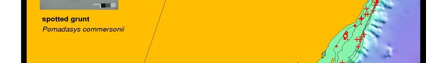
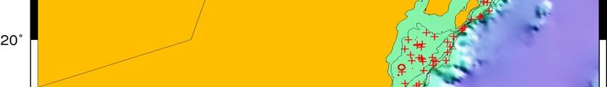


21 Maps!! catch by species/trip via GMT


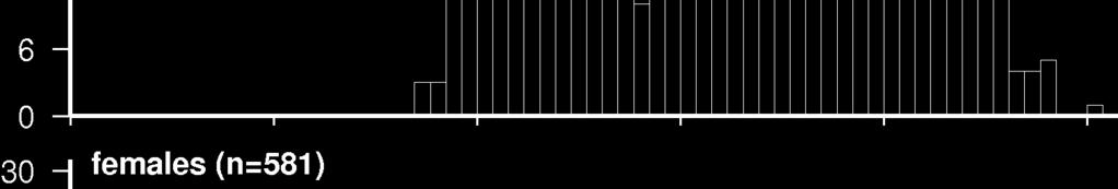


22 length frequency histograms by GMT Maps!!


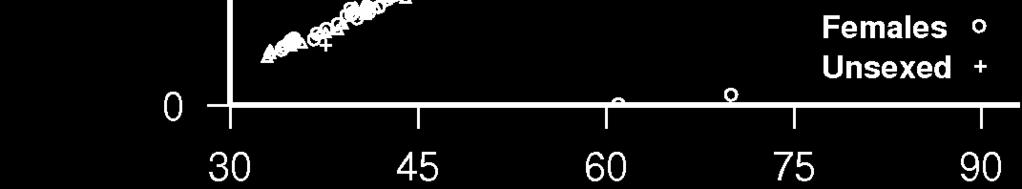
23 Maps!! length/weight plots by species via GMT
24 Summary the system as built robustly collected all data captured by the instruments and other devices and inserted them into a spatially enabled database supporting interactive GIS access for data queries and validation as well as on-demand map production for reports.


25 Acknowledgements: NIWA (National Institute for Water and Atmospheric Research Oman Ministry i of Fisheries i Wealth Independent Fisheries Limited Shallard and Associates
Acoustic Tools for Studying Marine Mammals. Sean Wiggins Scripps Institution of Oceanography
 Acoustic Tools for Studying Marine Mammals Sean Wiggins Scripps Institution of Oceanography http://cetus.ucsd.edu Whales and Dolphins of the World 5m 30m What do we need to know to conserve these animals?
5 Extract the information of location from the geometry column of PostgreSQL table
 5 Extract the information of location from the geometry column of PostgreSQL table Open QGIS and load PostGIS layer buildings and the raster layer Tai_wide_G (optional just to show the basemap). 1 Click
Database documentation for the Ministry for Primary Industries Acoustic database. Gavin Macaulay, Adam Dunford, NIWA
 Database documentation for the Ministry for Primary Industries Acoustic database Gavin Macaulay, Adam Dunford, NIWA June 21, 2016 Revision History Version Date Change Responsible 1.0 January 2006 First
Voyage Summary FV Rehua Trans-Tasman Voyage.
 Voyage Summary FV Rehua 200901 Trans-Tasman Voyage. Voyage dates: Depart Nelson, New Zealand Wednesday, 17 th June @ 18:15 hrs. Arrived Devonport, Australia Monday, 22 th June @ 14:00 hrs. Voyage name:
Seabird CTD Carousel Setup & Deck Unit Diagnostics
 Seabird CTD Carousel Setup & Deck Unit Diagnostics Conventional two pin Seabird pigtail terminations are standard on NOAA vessels and usually performed by the ET. So interfacing the CTD deck unit only
Advanced multipurpose Echosounder with single, dual or split beam
 ECHOSOUNDER Simrad ES60 Series Advanced multipurpose Echosounder with single, dual or split beam ALWAYS AT THE FOREFRONT OF TECHNOLOGY Simrad ES60 Echosounder with Single, Dual or Split Beam New features
RESEARCH VESSELS. Full Picture Delivery
 RESEARCH VESSELS Reflections and suggestions related to installation of hydroacoustic systems onboard research vessels with main focus on ice breakers Full Picture Delivery 5. DEKK 4. DEKK 3. DEKK 2. DEKK
Environmental Services Integrated Video Mapping SystemTM
 Environmental Services Integrated Video Mapping SystemTM OVERVIEW The collection and management of data during a field investigation is complex. The inputs of many sampling and measurement devices must
District Road Maintenance System (DROMAS) Operating Manual of DROMAS 2 (Version 2.0: DRAFT)
 Operating Manual of DROMAS 2 (Version 2.0: DRAFT)") District Road Maintenance System (DROMAS) Operating Manual of DROMAS 2 (Version 2.0: DRAFT) February, 2016 Table of Content 1 DISTRICT ROAD MAINTEANNCE SYSTEM (DROMAS)... 1 1.1 System Architecture... 1
District Road Maintenance System (DROMAS) Operating Manual of DROMAS 2 (Version 2.0: DRAFT) February, 2016 Table of Content 1 DISTRICT ROAD MAINTEANNCE SYSTEM (DROMAS)... 1 1.1 System Architecture... 1
Sea-Bird University MODULE LIST
 Sea-Bird University MODULE LIST MARTINI, KIM seabird.com Copyright 2017 Sea-Bird Scientific MODULE 0 Introduction, Course Plan and Syllabus SBE Training Introduction Modules by the numbers Topics We Will
SPECIFICATION FOR GMT VECTOR DATA FORMAT FOR OGR COMPATABILITY. DRAFT v0.2. Brent Wood
 SPECIFICATION FOR GMT VECTOR DATA FORMAT FOR OGR COMPATABILITY DRAFT v0.2 Brent Wood pcreso@pcreso.com Background. The National Institute for Water and Atmospheric Research (NIWA) in New Zealand is funding
MOSS MULTI OPERATION SURVEY SYSTEM MULTIPURPOSE TOOL FOR FIELD APPLICATIONS AND SURVEY JOBS
 MOSS MULTI OPERATION SURVEY SYSTEM MULTIPURPOSE TOOL FOR FIELD APPLICATIONS AND SURVEY JOBS TARKA-SYSTEMS COMPLETE SYSTEM INTEGRATION SENSORS/HARDWARE/SOFTWARE FOR PROJECT MONITORING www.tarka-systems.nl
WebEasy GIS is a cloud computing application for the web consultation of maps and geographic data.
 WebEasy GIS Geographic Information System WebEasy GIS is a cloud computing application for the web consultation of maps and geographic data. WebEasy GIS has a practical and intuitive interface, it works
High-performance mean currents and turbulence, wave height and direction
 High-performance mean currents and turbulence, wave height and direction The ADCP is the optimal tool for turbulence measurements. With a maximum sampling frequency of 16 Hz, it gives the scientific community
ichart Software Operations Manual and Reference Guide Revision
 1328 Parkway Court Beavercreek OH 45432 Phone: (937) 426-2703 Fax: (937) 426-1125 E-Mail: info@nexsens.com Visit us on the web at http://www.nexsens.com ichart Software Operations Manual and Reference
Datalogger Gealog SG. Datalogger Gealog SG. Gealog SG with graphic display
 Gealog SG with graphic display Page 1 of 13 Innovation leader in environmental monitoring stations The Gealog SG datalogger was especially designed for application in hydrometeorological measuring stations.
Dual-core Intel Atom processor. 1. The system is shipped without HDD. 2. For the HDD compatibility list, please visit
 VS-4008 Pro Hardware Spec. CPU HDD Dual-core Intel Atom processor 2.5/ 3.5" SATA x4 NOTE: 1. The system is shipped without HDD. 2. For the HDD compatibility list, please visit http://www.qnap.com/pro_compatibility.asp
NETWORK AUDIT FOR CHOPPY AND SONS, LLC
 GENERAL DESCRIPTION The data network at Choppy and Sons is an unswitched Ethernet LAN 100BT with LAN based Internet access via a cable modem link. There are 15 nodes on this peer to peer network, typical
Delph. Seabed Mapping Software Suite FEATURES ABOUT DELPH SOFTWARE SUITE BENEFITS APPLICATIONS
 Delph Seabed Mapping Software Suite Delph Seismic, Delph Sonar and Delph Mag are complete software packages with dedicated acquisition, processing and interpretation components. They operate with any sidescan
AT76.09 Digital Image Processing in Remote Sensing using C Language
 AT76.09 Digital Image Processing in Remote Sensing using C Language Dr. HONDA Kiyoshi Associate Professor Space Technology Applications and Research Asian Institute of Technology honda@ait.ac.th 1 1. Introduction
Quad Core Intel Xeon Processor E3 NOTE: 12 x hot-swappable and lockable tray. 4 x Gigabit RJ-45 Ethernet port. Status, 10 GbE, LAN, esata, hard drives
 VS-12140U-RP Pro Hardware Spec. Processor HDD Capacity Quad Core Intel Xeon Processor E3 12 x 3.5-inch SATA 6Gb/s, SATA 3Gb/s hard drive NOTE: 1. The system is shipped without HDD. 2. For the HDD compatibility
Software for HOBO loggers
 Measurement, Control, and Datalogging Solutions Software for HOBO loggers HOBOware Software Pro and Lite versions HOBOware Pro is available for both for Windows and MAC and is Onset's most powerful software
Specifications for: OSOP Raspberry Boom and 'Shake and Boom'
 Specifications for: OSOP Raspberry Boom and 'Shake and Boom' - Your Personal Acoustic and Seismo-Acoustic Home Science Monitors - An IoT home-automation device Born on: July, 2017 http://shop.raspberryshake.org/
Add A Network Printer Windows 7 Time Capsule
 Add A Network Printer Windows 7 Time Capsule On a previous PC I added a printer to the time capsule's IP 192.168.1.2 and printed with a generally if we know the printer IP address we can add it through
2 x 3.5" SATA I/II hard disk drive (HDD) 1. The system is shipped without hard disk drives. 2. For the HDD compatibility list, please
 1. The system is shipped without hard disk drives. 2. For the HDD compatibility list, please") VS-2008L Hardware Spec. CPU DRAM Flash Memory Hard Disk Drive Marvell 6281 1.2GHz 256MB DDRII RAM 16MB 2 x 3.5" SATA I/II hard disk drive (HDD) NOTE: 1. The system is shipped without hard disk drives.
VS-2008L Hardware Spec. CPU DRAM Flash Memory Hard Disk Drive Marvell 6281 1.2GHz 256MB DDRII RAM 16MB 2 x 3.5" SATA I/II hard disk drive (HDD) NOTE: 1. The system is shipped without hard disk drives.
Communication Interface
 Communication Interface Com'X 200/Com'X 210/Com'X 510 Technical data sheet Communications & gateways Com'X 200 / 210 Energy data loggers Main functions 1. Measure 2. Connect 3. Save PB114855 Wireless Meter
Quick Start: GeoDAS-LT with Single Beam Echo Sounder
 Quick Start: GeoDAS-LT with Single Beam Echo Sounder I. Setting up GeoDAS-LT for Single Beam Echo Sounder Survey 1. Connect your single beam echo sounder, GPS receiver and other sensors (e.g. gyro and
Dual-core Intel Atom processor. 2 x 3.5" SATA(II)/2.5" SATA/SSD. 1. The standard system is shipped without HDD.
/2.5 SATA/SSD. 1. The standard system is shipped without HDD.") VS-2012 Pro Hardware Spec. Processor HDD Capacity Dual-core Intel Atom processor 2 x 3.5" SATA(II)/2.5" SATA/SSD NOTE: 1. The standard system is shipped without HDD. 2. For the HDD compatibility list,
VS-2012 Pro Hardware Spec. Processor HDD Capacity Dual-core Intel Atom processor 2 x 3.5" SATA(II)/2.5" SATA/SSD NOTE: 1. The standard system is shipped without HDD. 2. For the HDD compatibility list,
Ammonit Meteo-40 Data Logger
 Wind and Solar Energy Assessment. SCADA. Power Curve Measurement. Ammonit Meteo-40 Data Logger Accurate. Reliable. Efficient. Wind and Solar Maps Wind Resource Assessment Solar Resource Assessment Solar
Dual-core Intel Atom processor. 6 x 3.5" SATA(II)/2.5" SATA/SSD. 1. The standard system is shipped without HDD.
/2.5 SATA/SSD. 1. The standard system is shipped without HDD.") VS-6020 Pro Hardware Spec. Processor HDD Capacity Dual-core Intel Atom processor 6 x 3.5" SATA(II)/2.5" SATA/SSD NOTE: 1. The standard system is shipped without HDD. 2. For the HDD compatibility list,
VS-6020 Pro Hardware Spec. Processor HDD Capacity Dual-core Intel Atom processor 6 x 3.5" SATA(II)/2.5" SATA/SSD NOTE: 1. The standard system is shipped without HDD. 2. For the HDD compatibility list,
Intel Core i processor. 8 x 3.5-inch SATA 6Gb/s, SATA 3Gb/s hard drive. 1. The system is shipped without HDD.
 VS-8124 Pro+ Hardware Spec. Processor HDD Capacity Intel Core i3-2120 processor 8 x 3.5-inch SATA 6Gb/s, SATA 3Gb/s hard drive NOTE: 1. The system is shipped without HDD. 2. For the HDD compatibility list,
Veesta World Co. V-SCADA2000 Product Series. The cross platform SCADA system
 Veesta World Co. V-SCADA2000 Product Series The cross platform SCADA system 1 V-SCADA2000 Product Series 2 V-SCADA2000 Veesta SCADA Control System 2000 Product Series Overview V-SCADA2000 Series consist
Terms and definitions * keep definitions of processes and terms that may be useful for tests, assignments
 Lecture 1 Core of GIS Thematic layers Terms and definitions * keep definitions of processes and terms that may be useful for tests, assignments Lecture 2 What is GIS? Info: value added data Data to solve
Dual-core Intel Atom processor. 4 x 3.5" SATA(II)/2.5" SATA/SSD. 1.The standard system is shipped without HDD.
/2.5 SATA/SSD. 1.The standard system is shipped without HDD.") VS-4008U-RP Pro Hardware Spec. Processor HDD Capacity Dual-core Intel Atom processor 4 x 3.5" SATA(II)/2.5" SATA/SSD NOTE: 1.The standard system is shipped without HDD. 2.For the HDD compatibility list,
VS-4008U-RP Pro Hardware Spec. Processor HDD Capacity Dual-core Intel Atom processor 4 x 3.5" SATA(II)/2.5" SATA/SSD NOTE: 1.The standard system is shipped without HDD. 2.For the HDD compatibility list,
PROVIDE SOLUTIONS END TO END
 DENSE AUTOMATION (INDIA) PRIVATE LIMITED KALBURGI We Dense Automation Team has started to create milestones, and marked our presence in the beginning of 2018 and operate in the manufacturing of weather
2 Creating Vector Layers. 2.1 Creation of tables of PostgreSQL with geometry column for PostGIS
 2 Creating Vector Layers 2.1 Creation of tables of PostgreSQL with geometry column for PostGIS 2.2 Adding columns to tables of PostgreSQL through PostGIS connection from QGIS Premise: PostgreSQL user name=
Processor Dual Core Intel Core i Processor 3.3 GHz. 8 x 3.5-inch SATA 6Gb/s, SATA 3Gb/s hard drive. 1. The system is shipped without HDD.
 VS-8148U-RP Pro Hardware Spec. Processor HDD Capacity Processor Dual Core Intel Core i3-2120 Processor 3.3 GHz 8 x 3.5-inch SATA 6Gb/s, SATA 3Gb/s hard drive NOTE: 1. The system is shipped without HDD.
REMOTE MONITORING OF WEATHER AT NORWEGIAN AIRPORTS
 REMOTE MONITORING OF WEATHER AT NORWEGIAN AIRPORTS Kjell Hegg, Lasse Stenberg Norwegian Meteorological Institute, P.O Box 43, Blindern, NO-0313 Oslo, Norway, Tel. (+47) 22963227, Fax. (+47) 22963050, E-mail:
NET Data Logger. Centre Software Guide UDP GSMS NET HV, NET THR HV NS828 H / H2 / HX / S / S2. Revision [v1.0.4c]
![NET Data Logger. Centre Software Guide UDP GSMS NET HV, NET THR HV NS828 H / H2 / HX / S / S2. Revision [v1.0.4c]](/thumbs/72/67547231.jpg "NET Data Logger. Centre Software Guide UDP GSMS NET HV, NET THR HV NS828 H / H2 / HX / S / S2. Revision [v1.0.4c]") NET Data Logger Centre Software Guide UDP GSMS NET HV, NET THR HV NS828 H / H2 / HX / S / S2 Revision 120228 [v1.0.4c] ~ 1 ~ Contents 1. How to get data from NET Data Logger?... 3 2. Server Version Comparison...
NET Data Logger Centre Software Guide UDP GSMS NET HV, NET THR HV NS828 H / H2 / HX / S / S2 Revision 120228 [v1.0.4c] ~ 1 ~ Contents 1. How to get data from NET Data Logger?... 3 2. Server Version Comparison...
Data, Data, Everywhere. We are now in the Big Data Era.
 Data, Data, Everywhere. We are now in the Big Data Era. CONTENTS Background Big Data What is Generating our Big Data Physical Management of Big Data Optimisation in Data Processing Techniques for Handling
Specifications for: OSOP Raspberry Shake 3D
 Specifications for: OSOP Raspberry Shake 3D Unit - Your 3D Personal Seismograph - An IoT home-automation device Born on: February, 2017 http://shop.raspberryshake.org/ sales@raspberryshake.org Last updated:
VK1100. ATEN Control System - Compact Control Box
 VK1100 ATEN Control System - Compact Control Box The ATEN Control System, incorporating the ATEN Control Box (VK1100 or VK2100), the ATEN Configurator (VK6000) and the ATEN Control System App, is a standard
FleetBroadband brings ship-to-shore/ship-to-ship operational and social communications to the broadband IP era
 FleetBroadband brings ship-to-shore/ship-to-ship operational and social communications to the broadband IP era FELCOM250 and FELCOM500 are FURUNO s new Inmarsat FleetBroadband terminals, which delivers
Satellite Communications
 Satellite Communications Ryan Smith Maritime Market & Broadband Communications at sea changing dramatically New services offer global coverage and broadband speeds at an affordable prices Hardware is smaller,
Specifications of Mobile DVR VP 5004
 Specifications of Mobile DVR VP 5004 Model Name Video Input VP-5004 Video BNC input x 4 *CHANGEABLE / CUSTOMIZED AVAILABLE* Note: VP-5004 also supports IP Camera over Cat5 cable. Please contact our sales
AGIC 2012 Workshop Leveraging Free RDBMS in ArcGIS
 AGIC 2012 Workshop Leveraging Free RDBMS in ArcGIS Prescott, AZ October 2012 Instructors: Bo Guo, PE, PhD Terry Li Workshop Outline Part I Introduction Why RDBMS Discussion on Obstacles for using RDBMS
Remote sensing In situ T, S and tracers Velocity Observing systems. Course url: Talley SIO 210 (2013)
") SIO 210: I. Observational methods and II. Data analysis (combined single lecture) Fall 2013 I. Observations Reading: DPO 6.1, S16.1, S16.4, S16.5, S16.9 Remote sensing In situ T, S and tracers Velocity
SIO 210: I. Observational methods and II. Data analysis (combined single lecture) Fall 2013 I. Observations Reading: DPO 6.1, S16.1, S16.4, S16.5, S16.9 Remote sensing In situ T, S and tracers Velocity
USB Temperature and Humidity Data Logger Instruction Manual
 USB Temperature and Humidity Data Logger Instruction Manual 1 4 2 3 5 1. Display 2. Set key 3. + key 4. - key 5. USB port - 1 - 1. Temperature 4 2. MAX/MIN value 5 3. Humidity 1 2 3 4. Memory status 6
Specifications for: The Original (1D) Raspberry Shake by OSOP
 Raspberry Shake by OSOP") Unit Specifications for: The Original (1D) Raspberry Shake by OSOP - Your Personal Seismograph - An IoT home automation device Born on: October, 2016 http://shop.raspberryshake.org/ sales@raspberryshake.org
Unit Specifications for: The Original (1D) Raspberry Shake by OSOP - Your Personal Seismograph - An IoT home automation device Born on: October, 2016 http://shop.raspberryshake.org/ sales@raspberryshake.org
F SERIES MULTIBEAM FOR FISHERIES
 SEE IT ALL F SERIES DISCOVER A NEW WORLD WITH THE LATEST INNOVATION FROM WASSP Outstanding performance, versatility and value. That s what you expect and exactly what you get with the new F3 sonar from
Logging Eddy Covariance Datasets
 Logging Eddy Covariance Datasets Installation Guide Contents Configure the LI-7200RS or LI-7500RS 1 Adding an LI-7700 4 Adding a Biomet System 5 Connecting to FluxSuite 6 Cellular Communication for Eddy
Cisco WVC210 Wireless-G Pan Tilt Zoom (PTZ) Internet Video Camera: 2-Way Audio Cisco Small Business Video Surveillance Cameras
 Internet Video Camera: 2-Way Audio Cisco Small Business Video Surveillance Cameras") Cisco WVC210 Wireless-G Pan Tilt Zoom (PTZ) Internet Video Camera: 2-Way Audio Cisco Small Business Video Surveillance Cameras High-Quality, Flexible, Remote-Controlled Wireless Video Solution for Your
Cisco WVC210 Wireless-G Pan Tilt Zoom (PTZ) Internet Video Camera: 2-Way Audio Cisco Small Business Video Surveillance Cameras High-Quality, Flexible, Remote-Controlled Wireless Video Solution for Your
Energy consumption optimization for a wireless sensor for the IOT
 Energy consumption optimization for a wireless sensor for the IOT Francesco Orfei NiPS Lab, University of Perugia, Italy TSP S.r.l., Umbertide, IT francesco.orfei@nipslab.org Outline Introduction to the
Simrad EK80. Software Release Note Introduction
 Simrad EK80 Software Release Note 1.12.2 Introduction This document describes the changes introduced with the new software version. Product: EK80 Software version: 1.12.2 This software controls all functionality
COMPONENTS. The web interface includes user administration tools, which allow companies to efficiently distribute data to internal or external users.
 COMPONENTS LASERDATA LIS is a software suite for LiDAR data (TLS / MLS / ALS) management and analysis. The software is built on top of a GIS and supports both point and raster data. The following software
Database documentation
 Database documentation for Deepwater commercial database dw_cdb David Fisher based on Draft documentation by Ralph Coburn NIWA Fisheries Data Management Database Documentation Series Postgres Version 2.1
World Premium Points of Interest Getting Started Guide
 World Premium Points of Interest Getting Started Guide Version: 2.0 NOTICE: Copyright Pitney Bowes 2017. All Rights Reserved. 1 Table of Contents INTRODUCTION... 3 1. Preface... 3 2. Data Characteristics...
Geographic Information Systems. using QGIS
 Geographic Information Systems using QGIS 1 - INTRODUCTION Generalities A GIS (Geographic Information System) consists of: -Computer hardware -Computer software - Digital Data Generalities GIS softwares
2 x 3.5-inch SATA 6Gb/s, SATA 3Gb/s hard drive. 1. The standard system is shipped without HDD. 2. For the HDD compatibility list, please
 VS-2112 Pro+ Hardware Spec. Processor Memory HDD Capacity Dual-core Intel processor 4GB RAM 2 x 3.5-inch SATA 6Gb/s, SATA 3Gb/s hard drive NOTE: 1. The standard system is shipped without HDD. 2. For the
pgrouting extends the postgis/postgresql geospatial database to provide geospatial routing and other network analysis functionality.
 Workshop: 1 pgrouting extends the postgis/postgresql geospatial database to provide geospatial routing and other network analysis functionality. Attendee s previous knowledge: SQL (PostgreSQL, PostGIS)
Beyond PostGIS. New developments in Open Source Spatial Databases. Karsten Vennemann. Seattle
 New developments in Open Source Spatial Databases Karsten Vennemann Seattle Talk Overview Intro Relational Databases PostGIS JASPA INGRES Geospatial MySQL Spatial Support HatBox a user space extension
DVR SAMSUNG Digital Security Systems
 Your source for Advanced Digital Security Solutions SAMSUNG Digital Security Systems SELECTION SVR-5116 SVR-1650E SVR-1640E Image OS Windows XP Embedded Linux Embedded Linux Live / Record Rate 480fps/120fps(N),
AUDIN - 8, avenue de la malle Saint Brice Courcelles - Tel : Fax : Web : http:
 Equipment, facilities, and service networks for data collection/logging, data transfer via e-mail/website, and system streamlining can be established without special knowledge. Energy saving system in
IMS AMS 111 II. Automatic Weather Station. Easy and reliable weather monitoring anywhere
 IMS II Automatic Weather Station Easy and reliable weather monitoring anywhere IMS Automatic Weather Station FEATURES: Synoptic Observation Climatological Observation Environmental Monitoring Radiation
ANNEX AGRI/20 AGRO-METEOROLOGICAL EQUIPMENT & SPARE PARTS ANNEX AGRI / 20 - A. Equipment & spare parts
 ANNEX AGRI/20 AGRO-METEOROLOGICAL EQUIPMENT & SPARE PARTS ANNEX AGRI / 20 - A. Equipment & spare parts Total Qty. Proposed Allocation DHK ERB SUL Intend. use Compliment. Application Delivery 05-20-00001
World Premium Points of Interest Getting Started Guide
 World Premium Points of Interest Getting Started Guide Version: 2.3 NOTICE: Copyright Pitney Bowes 2019. All Rights Reserved. 1 Table of Contents INTRODUCTION... 3 1. Preface... 3 2. Data Characteristics...
Marushka Server. Product Specification
 Introductory Information Product Marushka Server represents a new generation of tools (devices) for publication and use of GIS data in the Internet and intranet. It is built on component technology in.net
Use of Image aided Navigation for UAV Navigation and Target Geolocation in Urban and GPS denied Environments
 Use of Image aided Navigation for UAV Navigation and Target Geolocation in Urban and GPS denied Environments Precision Strike Technology Symposium Alison K. Brown, Ph.D. NAVSYS Corporation, Colorado Phone:
Dennis Shields & David Benigni Office of Marine and Aviation Operations National Oceanic and Atmospheric Administration Silver Spring, Maryland USA
 NOAA Scientific Computer System (SCS) by Dennis Shields & David Benigni Office of Marine and Aviation Operations National Oceanic and Atmospheric Administration Silver Spring, Maryland USA The National
Setting up Hydromagic:
 To operate Eye4Software Hydromagic and RosePoint ECS software packages simultaneously, the CEESCOPE echo sounder must be connected to the acquisition PC using the Ethernet (LAN) cable. The two software
6 x 3.5-inch SATA 6Gb/s, SATA 3Gb/s hard drive. 1. The standard system is shipped without HDD. 2. For the HDD compatibility list, please visit :
 VS-6112 Pro+ Hardware Spec. Processor Memory HDD Capacity Dual-core Intel processor 4GB RAM 6 x 3.5-inch SATA 6Gb/s, SATA 3Gb/s hard drive NOTE: 1. The standard system is shipped without HDD. 2. For the
Installation and Configuration Guide
 Installation and Configuration Guide Trademark Notices Comtrol, NS-Link, and DeviceMaster are trademarks of Comtrol Corporation. Microsoft and Windows are registered trademarks of Microsoft Corporation.
Open architecture for Smart and Interoperable networks in Risk management based on In-situ Sensors. OSIRIS In-Situ Monitorization.
 Open architecture for Smart and Interoperable networks in Risk management based on In-situ Sensors WP-4200 2007/10/05 Page 1 GMV, 2007 OSIRIS project background Developed under the scope of the European
Dual Core Intel Core i3 3.3GHz Processor 4GB DDR3 RAM. 8 x 3.5 SATA 6Gb/s, SATA 3Gb/s hard drive. 1. The system is shipped without HDD.
 VS-8140U-RP Pro+ Hardware Spec. Processor DRAM HDD Capacity Dual Core Intel Core i3 3.3GHz Processor 4GB DDR3 RAM 8 x 3.5 SATA 6Gb/s, SATA 3Gb/s hard drive NOTE: 1. The system is shipped without HDD. 2.
32CH 4K 2U Swap Drive Bay Rackmount Standalone Network Video Recorder
 32CH 4K 2U 19 3.5 Swap Drive Bay Rackmount Standalone Network Video Recorder Features 32 Channel H.264 network camera Input Up to 4K H.264 network camera support Up to 1080P 120 FPS network camera support
GO XSE. Getting Started. simrad-yachting.com ENGLISH
 GO XSE Getting Started ENGLISH simrad-yachting.com Contents 7 Introduction 7 The Home page 8 Application pages 10 Basic operation 10 System Controls dialog 10 Turning the system on and off 11 Selecting
GETTING STARTED GUIDE. Cisco Small Business. NSS2000 Series Network Storage System
 GETTING STARTED GUIDE Cisco Small Business NSS2000 Series Network Storage System 2008 Cisco Systems, Inc. All rights reserved. OL-17953-01 Contents Chapter 1: Introduction 1 Benefits 1 About this Guide
GIS in agriculture scale farm level - used in agricultural applications - managing crop yields, monitoring crop rotation techniques, and estimate
 Types of Input GIS in agriculture scale farm level - used in agricultural applications - managing crop yields, monitoring crop rotation techniques, and estimate soil loss from individual farms or agricultural
NVR Champ Specification
 NVR Champ Specification NVR Champ System Diagram Main Features Linux embedded safer solution against PC crashes and virus attacks One-click setup for more than 100 brands of IP cameras findnvr free from
LANCNC FTP LAN network data server for CNC Controls
 FTP LAN network data server for Controls 2008-2009 LLC, All rights reserved LLC 9909 Topanga Canyon Blvd. #322 Chatsworth, CA 91311 www.calmotion.com -1 2008-2009 LLC, All rights reserved Introduction
Cisco WVC210 Wireless-G Pan Tilt Zoom (PTZ) Internet Video Camera: 2-Way Audio Cisco Small Business Video Surveillance Cameras
 Internet Video Camera: 2-Way Audio Cisco Small Business Video Surveillance Cameras") Cisco WVC210 Wireless-G Pan Tilt Zoom (PTZ) Internet Video Camera: 2-Way Audio Cisco Small Business Video Surveillance Cameras High-Quality, Flexible, Remote-Controlled Wireless Video Solution for Your
Cisco WVC210 Wireless-G Pan Tilt Zoom (PTZ) Internet Video Camera: 2-Way Audio Cisco Small Business Video Surveillance Cameras High-Quality, Flexible, Remote-Controlled Wireless Video Solution for Your
Handout. and. brief description. Marine Gravity Meter KSS 32- M
 and brief description of Marine Gravity Meter KSS 32- M Copyright 1999-2010 Bodensee Gravitymeter Geosystem GmbH All rights reserved 1 KSS32-M Marine Gravity Meter Cover removed Copyright 1999-2010 Bodensee
Subject: ASC/2M Ethernet Connection Using Comtrol DeviceMaster RTS
 Reference: AN1064 Date: 6/22/05 GENERAL This application note describes a method and the required hardware components to implement an Ethernet type communications connection between an Aries Communication
BIPAC-645 DSL/Cable Router Plus ISDN Router With 4-Port 10/100M LAN Switch
 BIPAC-645 DSL/Cable Router Plus ISDN Router With 4-Port 10/100M LAN Switch Quick Start Guide Quick Start Guide Package Contents 1. BIPAC-645 2. AC Power Adapter (9V 1Amp) 3. RS-232 cable (Null modem type)
Using a GTD on a Seabird 911 CTD
 Using a GTD on a Seabird 911 CTD Connecting the GTD The GTD nitrification sensor can run as either an autonomous logging unit or use the RS232 uplink. If the uplink option is not available, using the provided
Specifications for: OSOP Raspberry Shake 4D
 Specifications for: OSOP Raspberry Shake 4D - Your 4D Personal Seismograph & Accelerograph - An IoT home-automation device Born on: February, 2017 http://shop.raspberryshake.org/ sales@raspberryshake.org
All NEW Q330S. March, 2010 QUG, Prague Mathias Franke
 All NEW Q330S March, 2010 QUG, Prague Mathias Franke Q330 Brief Overview Q4120, Q680, Q720 The Predecessors Q330 ~5,000 in operation, > 700,000 hours MTBF ISO 9001 Q330HR the ONLY 26 bit, now with 152
QK-A031 NMEA 0183 Multiplexer with SeaTalk Converter Features
 QK-A031 NMEA 0183 Multiplexer with SeaTalk Converter Features Multiplex up to three NMEA 0183 input devices Galvanically isolated NMEA and SeaTalk input ports Configurable baud rates: (4.8, 9.6, 38.4k
EM 120 Multibeam Echosounder
 EM 120 Multibeam Echosounder The EM 120 multibeam echosounder from Kongsberg was used for bathymetric surveying. The system has an operating frequency of 12 khz, suitable for deep ocean waters, and 191
Win 7 Drivers For Dvd Driver Your Network Adapter
 Win 7 Drivers For Dvd Driver Your Network Adapter For Laptops and Desktop PCs AC Adapters Mice/Keyboards Batteries Software Download drivers, software patches, and other updates for your Toshiba product.
A platform to build smart solutions for everyday ease
 A platform to build smart solutions for everyday ease The Internet of Things (IoT) is an environment in which objects, animals or people are provided with unique identifiers and the ability to transfer
2.01 CCTV TIME LAPSE VIDEO RECORDER SPECIFICATIONS
 ARCHITECT & ENGINEER SPECIFICATIONS SECTION 16780 VIDEO SURVEILLANCE SYSTEMS HSR-X216/32 Digital Surveillance Recorder PART 2 PRODUCTS 2.01 CCTV TIME LAPSE VIDEO RECORDER SPECIFICATIONS A. VIDEO - GENERAL
Laboratories. CL-1: Inventory/Facility
 Laboratories CL-1: Inventory/Facility 1. Total Number of Systems: 121 2. Configuration: (a) System: HP COMPAQ P IV {1 SYSTEM} Processor: 3.00 GHZ/915 CHIPSET RAM: 1 GB HDD : 80GB Monitor: Color, 15, K/B,
Introduction to Geodatabase and Spatial Management in ArcGIS. Craig Gillgrass Esri
 Introduction to Geodatabase and Spatial Management in ArcGIS Craig Gillgrass Esri Session Path The Geodatabase - What is it? - Why use it? - What types are there? - What can I do with it? Query Layers
GRASS. Geographic Resources Analysis Support System Current versions. Related software
 GRASS Geographic Resources Analysis Support System http://grass.osgeo.org Current versions 6.3 stable (old) 6.4 next stable (new) 7 development (future) Related software QGIS http://qgis.org GRASS Capabilities
Transducer and LBL calibration - Integrated functions in HiPAP systems
 Transducer and LBL calibration - Integrated functions in HiPAP systems Dynamic Positioning Conference, Houston, September 17-18 2002 arranged by 1 Calibration of transducer alignment and of LBL array This
Using a Geographic Information System (GIS) to look at marine fisheries data
 to look at marine fisheries data") Using a Geographic Information System (GIS) to look at marine fisheries data Daniel Sheehan GIS Programmer & Analyst Office of Educational Innovation & Technology dsheehan@mit.edu x2-1475 Introduction
Using a Geographic Information System (GIS) to look at marine fisheries data Daniel Sheehan GIS Programmer & Analyst Office of Educational Innovation & Technology dsheehan@mit.edu x2-1475 Introduction
AT Ground Surveillance System (GSS)
") AT Ground Surveillance System (GSS) AT Ground Surveillance System (GSS) AT Ground Security Sensors The AT Ground Surveillance System (GSS) is integrated network of sensors, cameras and mesh radio network
AT Ground Surveillance System (GSS) AT Ground Surveillance System (GSS) AT Ground Security Sensors The AT Ground Surveillance System (GSS) is integrated network of sensors, cameras and mesh radio network
Making Airtime Count. Wednesday, December 14, 11
 Making Airtime Count. GMN 1 Introductions Dr. Luis Soltero, Ph.D., MCS CTO and President Founded Global Marine Networks in 2002 John Dark Sales and Marketing 11 years in MSS, including 9 years as primary
Enterprise GIS for Managing Reservation Land
 Enterprise GIS for Managing Reservation Land Beckie Howell GIS Manager Agua Caliente Band of Cahuilla Indians ESRI UC 2014 Tribal Indigenous GIS Track Empowering Tribal Governments with Enterprise GIS