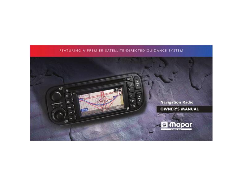
Navigation System... 1 Radio Frequently Asked Questions Troubleshooting MAIN TABLE OF CONTENTS
|
|
|
- Wendy Paul
- 5 years ago
- Views:
Transcription
1
2 Navigation System... 1 Radio Frequently Asked Questions Troubleshooting MAIN TABLE OF CONTENTS i
3 NAVIGATION SYSTEM TABLE OF CONTENTS Safety Guidelines... 1 System Introduction... 3 System Overview...3 System Features...3 System Limitations...5 Navigation at a Glance...7 Controls and Pushbuttons...9 Steering Wheel Controls...10 Operation Software Initialization...11 Inputting Information...12 Main Menu Screen...13 Map and Arrow Guidance Screens...14 Confirm Destination Screen...15 Destination Menu Street Address...18 Point of Interest...20 Recent Route...22 Phone Number...22 Intersection...23 Address Book...25 Trip Itinerary Map Cursor Setup Menu...28 Setting Display Properties Setting Guidance Properties Setting a Language and Unit of Measure Option Menu...32 Saving the Current Position Edit Viewing GPS Information Viewing System Information Route Menu...36 Deleting the Current Destination Maneuver List Creating a Detour Changing Current Method Using the Trail Function...38 Creating a Trail Using a Trail as a Destination ii
4 SAFETY GUIDELINES Ensure that all persons read this manual carefully before using the navigation system. It contains instructions on how to use the system in a safe and effective manner. Warning: Please read and follow the following safety precautions. Failure to do so may result in injury or property damage. Do not operate the product while driving. Always stop the vehicle in a safe location before using the system. Do not use the navigation system to route you to emergency services such as police and fire stations or hospitals and clinics. Not all emergency service locations are contained in the database. Please use your own judgment and ask for directions in such situations. Glance at the screen only when necessary and safe to do so. If prolonged viewing of the screen is necessary, pull over at a safe location. Road conditions and regulations take precedence over information contained on the map display. Observe actual traffic restrictions and circumstances while driving. Stop use immediately if a problem occurs. Failure to do so may cause injury or damage to the product. Return it to your authorized DaimlerChrysler dealer for repair. Do not place fingers or foreign objects into the CD/DVD- ROM insertion slot. Doing so may result in injury or damage to the product. Always check the CD player for discs before inserting another disc. Failure to do so may cause damage to the system. There may be situations where the navigation system erroneously displays the vehicle's location. Use your own driving judgment in this situation, taking into account current driving conditions. Please be aware that in this situation the navigation system should automatically correct the vehicle's position within a few minutes. Take care when removing a disc from the CD player. The disc might be hot. 1
5 SAFETY GUIDELINES Make certain that the volume level of the monitor is set to a level that still allows you to hear outside traffic and emergency vehicles. The map database is designed to provide you with route suggestions and does not take into account the relative safety of a suggested route or of factors that may affect the time required to reach your destination. The system does not reflect road closures or construction, road characteristics (i.e. type of road surface, slope or grade, weight or height restrictions, etc.), traffic congestion, weather conditions, or any other factors that may affect the safety or timing of your driving experience. Use your own personal judgment if the navigation system is unable to provide you with an alternate route. If you have any questions about the operation of the navigation system, please contact a local DaimlerChrysler dealer or Alpine Customer Service at
6 SYSTEM INTRODUCTION Welcome to your new Navigation System. The information in this Owner s Manual is designed to help you begin using your system quickly and safely. It contains the following information to help you become familiar with the system: Safety guidelines System features System limitations Detailed descriptions of system menus and controls Before using the system, please take some time to familiarize yourself with the information included in this manual. System Overview Your navigation system receives GPS signals from up to 8 satellites to display the position and direction of your vehicle. Map and database information is supplied through a DVD- ROM. A gyroscope and the vehicle s speed sensor enable the system to display the present vehicle position even in locations where GPS signals may be blocked. When you input a destination, the navigation system uses map data from the DVD-ROM to quickly calculate a route. As you drive along your chosen route, you are guided with pictorial displays and voice prompts. System Features Multiple Mode Destination Selection Destinations can be selected from these 8 categories: an address an intersection a point of interest (POI) a recent destination your personal address book a special feature called Trip Itinerary a location selected directly from the map display a phone number Street Name Input This allows you to input your destination's street name (via Address or Intersection search) if you don't know your destination's city name. 3
7 SYSTEM INTRODUCTION 4 Next Maneuver Guidance When an upcoming turn is approaching, the system will give maneuver instructions via arrow guides and simple voice prompts. Voice Guidance Using voice prompts, the system will notify you of upcoming turns and highway entrances. Map Zoom The map display has 9 different zoom scales to allow you to increase or decrease map magnification. Recent Route Up to 10 previous destinations can be stored in the Recent Route list. Faster Input Using Smart Key Filtering When you use the digital keyboard to input information, the system makes educated guesses based on previously entered letter combinations and displays only the characters necessary to input your destination. GPS Clock The clock will automatically adjust according to GPS time. This time is also displayed directly on the map along with your estimated time of arrival (ETA) or estimated drive time remaining (TO GO). Trails You can display a "bread crumb" trail that appears on the Map screen as you drive along your route. This feature helps to log where you have traveled and is also useful for "off-roading". Different Languages The navigation system can guide you in three different languages: English, Spanish, and French. The text and guidance are in your language of choice. Address Book Up to 100 personal locations and phone numbers can be stored in the system s memory. Up to 10 custom Address Book folders can be created. Popular Points of Interest (POI) The navigation system s database contains thousands of
8 SYSTEM INTRODUCTION points of interest in many different categories. Seven different POI icons can be programmed to appear on the map. These icons indicate the locations and names of the nearest ATMs, Banks, Gas Stations, Restaurants, Hotels, Parking Garages, and Grocery Stores. Three of the 7 categories of icons can be displayed on the map screen at one time. Routing Options You can program the system to minimize the use of toll roads and freeways or to provide the quickest route. If you go off course at any time, the system can automatically recalculate a route to the destination from your present location. System Limitations The DVD-ROM that is included with your system contains the most recent map data available at the time of production. Because of changes in streets, neighborhoods, and business locations, there may be situations where the navigation system is not able to route you to your desired destination by the entry method you have chosen. If this occurs, choose another entry method. For example, if the system doesn t recognize the street address you are searching for, try to find your destination by inputting the closest cross street names (see Intersection on page 23). Software upgrades are available to keep your system current. To obtain information about upgraded map data, please call Alpine Customer Service at (Monday through Friday, 9 am to 5 pm Eastern Standard Time). Vehicle Position While the system uses multiple inputs to determine vehicle position, there are factors that may cause the position to be displayed incorrectly: Weak GPS reception caused by the obstruction of satellite signals (tall buildings, tunnels, indoor parking lots). Road mismatch. If there is an adjacent road within approximately feet (10-30 meters) of your current position, the system may display your vehicle on the adjacent road. Non-use of navigation disc for several days. If the naviga- 5
9 SYSTEM INTRODUCTION tion disc is removed from the navigation system and reinserted at a later date, the navigation system may temporarily display an incorrect vehicle position. not press CANCEL or NAV and wait until the vehicle comes to a complete stop before inputting any further information. Driving the vehicle in an area of good GPS reception should correct these errors so that the vehicle position is correctly displayed. (Please note, it may take several minutes for the system to correct the vehicle position.) In-Motion Operation Your navigation system is equipped with a safety feature that limits the availability of certain navigation tasks while the vehicle is in motion. Programmable options such as editing the personal address book or inputting a destination will be unavailable and grayed out until the vehicle comes to a complete stop. Point of Interest selection is limited: you can choose from a list of the last 5 POIs that were entered. NOTE: If you try to input information while the vehicle is in-motion, the system will display a message prompting you to press CANCEL or NAV. Please note that pressing either of these buttons will cause your input information to be deleted. To prevent this information from being lost, do 6
10 SYSTEM INTRODUCTION Navigation at a Glance The following example briefly describes how to use the navigation system. In this example you will learn how to find a destination using a known street address. 1. Turn the unit on by pressing the PUSH ON/VOL button. Press the NAV button to activate the navigation system. The opening screen appears followed by a disclaimer screen. Press EN- TER to accept this statement. 2. The Main Menu screen appears. Use the Select Encoder to highlight the desired option. In this example we will be searching for an address by destination, so highlight Destination. Press ENTER to continue. 3. The Find Destination by screen appears. At this screen you can search for your destination in several ways. In this example we are searching by street address, so highlight Street Address. Press ENTER. 4. The Find Address by screen appears. There are 4 options to choose from: Street Name, City Name, Change State, and Change Province. Highlight Street Name and press EN- TER. 5. The Input Street Name screen appears. Use the Select Encoder to spell out the desired street name. Highlight the first 7
11 SYSTEM INTRODUCTION letter of the street name and press ENTER. Highlight the second letter and press ENTER. Continue this process until the name is spelled out. Highlight Street List and press ENTER to continue. 6. The Select Street Name screen appears. Select a street name and press ENTER. 7. The Input Address Number screen appears. Use the Select Encoder to input the address number. Use the same procedure that you used for inputting the street name in Step 5. When you are finished, highlight Done and press ENTER. NOTE: If the chosen address is in more than one city, the Select a City screen will appear. If this is the case, highlight the correct city and press ENTER to continue. 8. The Confirm Destination screen appears. This screen shows the address of the input destination. If this is your desired destination, highlight OK and press ENTER. The system will now calculate your route for you. 9. When your route has been calculated, the Map screen will appear. You are now ready to begin traveling to your desired destination. 10. Proceed to the route. When driving begins, voice directions and map displays will guide you to your destination. The map will show the destination as a star. NOTE: For more information about the screens used in this example and the options associated with them, please refer to the appropriate section in this manual. 8
12 SYSTEM INTRODUCTION Controls and Pushbuttons There are several controls that you will frequently use when using the navigation system: 1. Power/Volume Control knob 2. Select Encoder 3. ENTER button 4. CANCEL button 5. NAV button The Power/Volume Control knob is used to turn the navigation radio on and off and to adjust the volume of the navigation voice command. To turn the navigation radio on or off, press the knob in. To raise or lower the volume of the voice guidance during a voice command, turn the knob to the left or right. The Select Encoder and ENTER button work together to input route information. The Select Encoder is used to scroll through navigation menus and map icons. The ENTER button is used to input highlighted information into the system. When you highlight a menu or map item using the Select Encoder and press ENTER, the system will take you to the next screen. The CANCEL button is similar to the back button on a computer. When pressed, CANCEL will return you to the previous screen. 4 5 The NAV button allows you to access the Main Menu screen from anywhere in the navigation system. 9
13 SYSTEM INTRODUCTION Steering Wheel Controls (if equipped) In addition to the faceplate controls, there are also remote buttons that control the navigation system. They are located under the left and right sides of the steering wheel. Scroll up or counterclockwise ENTER Press once CANCEL Press for 3+ seconds Scroll down or clockwise LEFT The left button controls the scroll, enter, and cancel functions of the navigation system. Press the top of the button to scroll up or counterclockwise. Press the bottom of the button to scroll down or clockwise. To simulate the ENTER function, press the middle of the button once. To simulate a CANCEL function, press the middle of the button for more than 3 seconds. 10 The right button controls voice guidance volume and the NAV button function. Volume up NAV Press for 3+ seconds. Volume down RIGHT You can use the steering wheel controls to adjust voice guidance volume ONLY during a voice command. Press the top of the button to increase the volume of the voice guidance. Press the bottom of the button to decrease the volume of the voice guidance. To simulate the NAV button function, press the middle of the button for more than 3 seconds.
14 OPERATION Software Initialization Before you use your navigation system for the first time or when installing software updates, the system software will need to be written to the system. 1. Turn the ignition key to the ON position. The opening screen should appear on the monitor display. 5. Drive the vehicle several miles in an area with an open view to the sky. This will correctly synchronize the navigation system. NOTE: When powering on the unit for the first time, it takes the GPS receiver approximately 10 minutes to calculate the vehicle's current position. During this period, the vehicle position icon may not move even if the vehicle is being driven. 2. If installing a software update, remove the old version of the map disc from the DVD player. 3. Insert the new DVD-ROM map disc into the DVD player. The system will automatically begin downloading the software. NOTE: Do not turn off the vehicle's engine or operate the navigation system during program writing. 4. The opening screen appears when the download is complete. 11

15 OPERATION Inputting Information Keyboard Features 1 2 Input Process To input a name or number into the system, use the Select Encoder to highlight the first character of the name/number and press ENTER. The character will appear in the text window. The system will display only the character matches for the next entry. All unnecessary characters are grayed out. Select from the characters remaining and press ENTER. Repeat this process until the entry is complete Match Shows the number of possible character matches. 2. Space button Creates a space between words. 3. List function (available only when inputting street or intersection name, POI place name, or destination by phone number) Displays a list of the names or numbers for the selected characters. You can search for a name or phone number by inputting the first few characters and selecting List. A list of the closest matching selections will appear. 4. Delete Deletes characters entered in the text window. 3 Helpful Hints Make sure you input the exact name into the system. If the name is spelled wrong or is missing characters (i.e. apostrophe, dash, space), the system may route you to the wrong location. For best results when inputting a highway, enter the highway number exactly as it appears on the highway sign. For example, Interstate 75 should be input as I-75, not I75. You do not have to input a N, S, E, or W designation. A list of all possible highways will be displayed after you select Street List. 12
16 OPERATION Main Menu Screen All navigation operation begins at the Main Menu screen. At the Main Menu screen you can access 4 other menu screens: Destination, Setup, Option, and Route. From the Main Menu screen you can also view the Map screen. NOTE: To access the Main Menu screen from anywhere in the system, press the NAV button. Select Destination when you want to program a destination. You can input a destination in one of 8 ways: street address, point of interest, recent route, address book, phone number, trip itinerary, intersection, and map cursor. Select Setup when you want to adjust the settings of the navigation system. Through this menu you can change vehicle orientation display, turn trail display on or off, set beep prompt frequency, select guidance map display, view arrival time or time remaining to the destination, change rerouting methods, change system language properties, and change the unit of measure. Select Option to edit entries and view system information. You can save the current position of the vehicle to the recent route list, view the position of your vehicle, view the number of satellites the system is receiving, view system information, and edit the recent route list, address book entries, and the trip itinerary. Select Route to edit the properties of a programmed route. This screen is available only when a destination is programmed into the unit. It allows you to delete the current destination, display a turn-by-turn listing of your route, and create a detour. You can customize the route by telling the system to use the quickest route, travel by freeway, or minimize toll road travel. Select Map to view a map of your current position. 13

17 OPERATION Map and Arrow Guidance Screens The Map screen is displayed after a route has been calculated. You can also access it by highlighting Map on the Main Menu screen. The Map screen displays a detailed road map that shows the following information: Icons Next Maneuver Distance to Next Maneuver Current Location Name of Next Maneuver Current Position Radio Bar GPS Clock Icons At the right of the Map screen are 4 icons: Orientation Shows orientation of vehicle: North Up or Heading Up icons Information Shows estimated time of arrival and distance to destination Voice Repeats the current voice command Arrow Activates the Arrow screen Three more icons are located on the left side of the screen: Trail Activates Trail mode Map Scroll Allows manual scrolling of map Zoom Scale Increases or decreases the route magnification To access the icons, use the Select Encoder to highlight an icon, then press ENTER. 14

18 OPERATION The Arrow screen displays turn-by-turn guidance. To access this screen from the Map screen, highlight the Arrow icon and press ENTER. To return to the Map screen, highlight the Map icon and press ENTER. The Information and Voice icons are also displayed on this screen. Name of Next Maneuver GPS Clock Confirm Destination Screen After you have input your destination information into the system, the Confirm Destination screen appears. This screen displays the name and address of your destination, as well as the current routing method. At the bottom of the screen are 3 buttons : OK, Map, and Options : Select OK to proceed to route calculation. Select Map to verify or modify the location of your destination on the map. Select Options to add the destination to your trip itinerary, save the location in your address book, find local POIs, or change the routing method. Distance to Next Maneuver Current Location Next Maneuver Radio Bar Icons 15
19 OPERATION Using the Options menu 1. From the Confirm Destination screen highlight Options and press ENTER. 2. The Select screen appears. 3. Highlight the desired option. Adding an address to Trip Itinerary Up to 10 addresses can be added to the Trip Itinerary function. 1. Highlight Add to Trip Itinerary. Press ENTER. NOTE: If the current destination has been set using the Trail function, or if the Trip Itinerary list is full, Add to Trip Itinerary will be grayed out and unavailable. 2. The Trip Itinerary List screen appears with the added destination highlighted. Press ENTER. 3. The Find Destination by screen appears. To add more entries to Trip Itinerary, input a destination then repeat this procedure. 16 NOTE: To edit the Trip Itinerary list, see the Option menu section entitled Editing Trip Itinerary. Adding a destination to the Address Book The Address Book can store up to 100 addresses and phone numbers. 1. Highlight Save in Address Book and press ENTER. NOTE: If the Address Book is full, Save in Address Book will be grayed out and unavailable. 2. The Input Name screen appears. Use the Select Encoder to spell out the name you would like to see in the address book. Select Done when finished and press ENTER. 3. The Input Phone Number screen appears. Use the Select Encoder to input the phone number of the address. When the number is complete, or if you do not know the phone number, highlight Save and press ENTER. 4. The name, address, and phone number are now stored in
20 OPERATION the address book. The Confirm Destination screen will reappear showing the saved information. Finding Local POIs This feature allows you to locate a point of interest near your destination and choose it as your new destination. 1. Highlight Find Local POI and press ENTER. 2. The Select Category screen appears. Select the desired point of interest and press ENTER. 3. The Select Name screen appears with a list of POIs. Select the POI and press ENTER. Changing Routing Method This feature allows you to customize your route by selecting the quickest route, minimizing or maximizing freeway travel, or minimizing toll roads. Only one option at a time may be chosen. 1. Highlight Change Routing Method and press ENTER. 2. Select the desired mode. Press ENTER. 3. The new routing method will now be shown on the Confirm Destination screen. The system will calculate the route using the new routing information. 4. The Confirm Destination screen appears showing the name and address of your selected point of interest. 17
21 DESTINATION MENU This section describes how to input your destination. The destination can be input in one of 8 different ways. 1. Highlight Destination and press ENTER. 2. The Find Destination by screen appears. 3. Select desired mode. Street Address If you know the address of the destination, the system can calculate the route to that address. 1. Select Street Address from the Find Destination by screen and press ENTER. 2. The Find Address by screen appears: Select Street Name to find a street address by inputting the street name and house or building number, if known. For this example, the Street Name input method is used. Select City Name if you want to search for an address in a particular city. Use this option for a more direct search. Select Change State to search for an address in a different state. Select Change Province to search for an address in a Canadian province. 3. Highlight Street Name and press ENTER. 18
22 DESTINATION MENU NOTE: The procedure for searching by City Name is similar to the Street Address procedure. Instead of inputting address information, however, input the name of a city. Follow the screens until you have input your city name. You will then be directed to input the street name. 4. The Input Street Name screen appears. Use the Select Encoder to spell out the street name. Highlight the first letter of the street name. Press ENTER. 5. The selected character appears in the text window. Input the rest of the name. Select Street List to continue. NOTE: If the chosen address is in more than one city, the Select a City screen will appear. If this is the case, highlight the correct city and press ENTER to continue. 8. The Confirm Destination screen appears showing the address of the selected destination. If it is correct, select OK and press ENTER. The system will calculate a route to the destination. NOTE: Select Options to add this destination to your Trip Itinerary, save it in your Address Book, locate local POIs, or change route options. Select Map to verify or modify the location of your destination on the map. (See Confirm Destination Screen section for more details.) 6. The Select Street Name screen appears. Select a street name and press ENTER. 7. The Input Address Number screen appears. Use the Select Encoder to input the address number. When you are finished, highlight Done and press ENTER. 19
23 DESTINATION MENU 20 Point of Interest This feature allows you to select a destination from a list of locations and public places, or point of interest (POI). You can search by place name (if known), or by category or place type. NOTE: The DVD-ROM that is included with your system contains the most recent map data available at the time of production. Because of changes in streets and neighborhoods, there may be situations where the system is not able to locate the desired destination by the entry method you have chosen. If this occurs, choose another entry method. 1. To find a destination by point of interest, select Point of Interest from the Find Destination by menu. Press ENTER. 2. The Find Point of Interest by screen appears. There are two options on this screen: Place Name or Place Type. If you know the name of the destination, select Place Name. If you wish to search by category, select Place Type. Press ENTER. Selecting a Point of Interest by Place Name 1. Upon selecting the Place Name option, the Input Name screen appears. Use the Select Encoder to select the first character of the place name. Press ENTER. The character will appear in the text window. Input the rest of the place name. Highlight Name List. Press ENTER. NOTE: Make sure you input the exact name into the system. If the name is spelled wrong or is missing characters (i.e. apostrophe, dash, space), the system may route you to the wrong location. 2. The Select Name screen appears. Scroll through the list. Select the desired location. Press ENTER. If there is more than one location to a place name, the system will display the number of locations available. In that case, highlight the desired place name and press ENTER. 3. The Confirm Destination screen appears showing the address of the selected destination. If it is correct, select OK. Press ENTER. The system will calculate a route to the destination.
24 DESTINATION MENU NOTE: Select Options to add this destination to your Trip Itinerary, save it in your Address Book, locate local POIs, or change route options. Select Map to verify or modify the location of your destination on the map. (See Confirm Destination Screen section for more details.) Selecting POI by Place Type 1. Upon selecting the Place Type option, the Select Category screen appears. Use the Select Encoder to locate the desired category. Press ENTER. NOTE: If you don t find the name of the category in this list, select Additional Category and input the name of the desired category. A list beginning with the closest match will appear. Make your selection from this list and continue. NOTE: When you select Restaurant as your place type, you will be prompted to choose a type of cuisine. 2. The Find Place Type by screen appears. You may search for place type in three ways: Sort by Distance, Name, Within a City. Select Sort by Distance to view the locations closest to the vehicle s position. The Select Name screen appears, displaying a list of place names for the selected category. The names are shown in order of proximity to the vehicle, with the closest location at the top of the list. Select the desired location and press ENTER. Select Name to find locations by a specific name. The Input Name screen appears. Use the Select Encoder to spell out the name of the POI. Highlight Name List and press ENTER. The Select Name screen appears. Select the desired location and press ENTER. Select Within a City to find locations within a particular city. The Input City Name screen appears. Use the Select Encoder to spell out the name of the city. Highlight City List and press ENTER. The Select Name screen appears, showing a list of place names within the desired city. Select the desired location and press ENTER. 21
25 DESTINATION MENU 3. The Confirm Destination screen appears showing the address of the selected destination. If it is correct, select OK. Press ENTER. The system will calculate a route to the destination. NOTE: Select Options to add this destination to your Trip Itinerary, save it in your Address Book, locate local POIs, or change route options. Select Map to verify or modify the location of your destination on the map. (See Confirm Destination Screen section for more details.) Recent Route If your destination is one of the 10 most recent route calculations you can use the Recent Route feature to recall that destination. NOTE: If there are no recent routes in the system, Recent Route will be grayed out and unavailable. 1. At the Find Destination by screen, select Recent Route. Press ENTER. 2. The Select Address screen appears. A list of up to 10 most recent destinations is displayed. Use the Select Encoder to highlight the desired destination. Press ENTER. 3. The Confirm Destination screen appears showing the address of the selected destination. If it is correct, select OK. Press ENTER. The system will calculate a route to the destination. NOTE: Select Options to add this destination to your Trip Itinerary, save it in your Address Book, locate local POIs, or change route options. Select Map to verify or modify the location of your destination on the map. (See Confirm Destination Screen section for more details.) Phone Number If you know the phone number of the destination, you can use this function to find the address. This function is available only when the phone number is stored in your personal address book or is listed in the database. NOTE: The system contains a database of Yellow Page business listings. It does not contain White Page listings. 22
26 DESTINATION MENU 1. From the Find Destination by screen select Phone Number. Press ENTER. 2. The Input Phone Number screen appears. Use the Select Encoder to highlight the first number of the phone number. Press ENTER. Input the rest of the phone number. Select Phone List. Press ENTER. 3. The Select Phone Number screen appears. Use the Select Encoder to select the phone number of the desired destination. Press ENTER. 4. The Confirm Destination screen appears showing the address of the selected destination. If it is correct, select OK. Press ENTER. The system will calculate a route to the destination. NOTE: Select Options to add this destination to your Trip Itinerary, save it in your Address Book, locate local POIs, or change route options. Select Map to verify or modify the location of your destination on the map. (See Confirm Destination Screen section for more details.) Intersection If you know the intersection near where you want to go, you can input two cross street names as your destination. 1. From the Destination screen, select Intersection. Press ENTER. 2. The Find Intersection by screen appears. Select Street Name to find an intersection by inputting street names. For this example, the Street Name input method is used. Select City Name if you want to search for the intersection in a particular city. Use this option for a more direct search. 23
27 DESTINATION MENU Select Change State to search for an intersection in a different state. Select Change Province to search for an intersection in a Canadian province. 3. Highlight Street Name and press ENTER. NOTE: The procedure for searching by City Name is similar to the Street Name procedure. Instead of inputting a street name, however, input the name of a city. Follow the screens until you have input your city name. You will then be directed to input a street name. 4. The Input Street Name screen appears. Use the Select Encoder to spell out the street name. Highlight the first letter of the street name. Press ENTER. 5. The selected character appears in the text window. Repeat this process until the name is spelled out. Select Street List to continue. 6. The Select Street Name screen appears. Select a street name and press ENTER. 7. The Input Cross Street Name screen appears. Use the Select Encoder to spell out the cross street name. When you are finished, highlight Street List and press ENTER. 8. The Select a Cross Street screen appears. Select the desired street and press ENTER. 9. The Confirm Destination screen appears showing the selected intersection. If it is correct, select OK and press ENTER. The system will calculate a route to the intersection. NOTE: Select Options to add this destination to your Trip Itinerary, save it in your Address Book, locate local POIs, or change route options. Select Map to verify or modify the location of your destination on the map. (See Confirm Destination Screen section for more details.) 24
28 DESTINATION MENU Address Book If a location has already been placed into your personal address book, you can recall that address for use as a destination. 1. From the Find Destination by screen, select Address Book. Press ENTER. NOTE: If there are no entries in the address book, Address Book will be grayed out and unavailable. 2. The Select Name screen appears showing a list of your address book entries. Select the desired address and press ENTER. 3. The Confirm Destination screen appears showing the address of the selected destination. If it is correct, select OK and press ENTER. The system will calculate a route to the destination. NOTE: Select Options to add this destination to your Trip Itinerary, locate local POIs, or change route options. Select Map to verify or modify the location of your destination on the map. (See Confirm Destination Screen section for more details.) Trip Itinerary If you are traveling to multiple destinations, the Trip Itinerary function will calculate the most efficient route. Up to 10 destinations can be stored in Trip Itinerary. 1. Add destinations to your trip itinerary list (see Confirm Destination Screen section). 2. From the Find Destination by screen, select Trip Itinerary. Press ENTER. NOTE: If there are no destinations stored in the trip itinerary, Trip Itinerary will be grayed out and unavailable. 3. The Select Sorting Method screen appears. Select the desired method of travel: In Order or Quickest Route. In Order will route you to each destination in the order in which it was entered. Quickest Route will route you to each destination in the most efficient travel order. 25
29 DESTINATION MENU 26 NOTE: To delete items from the Trip Itinerary list, see the Option menu section entitled Editing Trip Itinerary. 4. The Confirm Destination screen appears showing the address of the first destination. If it is correct, select OK. Press EN- TER. The system will calculate a route to the destination. NOTE: Select Options to save this destination in your Address Book, locate local POIs, or change route options. Select Map to verify or modify the location of your destination on the map. (See Confirm Destination Screen section for more details.) 5. When you reach your destination, the system will prompt you to your next destination depending upon the following conditions: If you turn the ignition off, the system will prompt you to confirm the next destination upon turning the ignition on again. If you do not turn the ignition off press CANCEL. The system will then prompt you to confirm the next destination before calculating the route to your destination. NOTE: If you press another button instead of CANCEL, you will have to re-enter the trip itinerary from the Main Menu screen. Map Cursor This feature allows quick and easy selection of a destination directly from the Map screen. By selecting a street segment or icon, you can quickly enter a destination without the need to input the city name or street. 1. From the Find Destination by screen, select Map Cursor. Press ENTER. 2. Using the Select Encoder, highlight any of the 8 arrows to select the direction you want to move. Press and hold the ENTER button to scroll through the map and locate your destination. NOTE: To move greater distances on the map, use the Select Encoder to highlight the zoom scale icon, then choose a level of magnification. NOTE: The Map Scroll feature will not work with the steering wheel controls. Use the Select Encoder only.
30 DESTINATION MENU 3. When you have located your destination, use the Select Encoder to highlight the center. Press ENTER. 4. A call-out balloon appears showing the address of the location. Press ENTER again to select the location. 5. The Confirm Destination screen appears showing the address of the selected destination. If it is correct, select OK and press ENTER. The system will calculate a route to the destination. NOTE: Select Options to add this destination to your Trip Itinerary, save it in your Address Book, locate local POIs, or change route options. Select Map to verify or modify the location of your destination on the map. (See Confirm Destination Screen section for more details.) 27
31 SETUP MENU 28 At the Setup menu you can set display properties, guidance properties, and a language and unit of measure. 1. At the Main Menu screen highlight Setup and press ENTER. 2. The Select menu appears. 3. Select the desired mode. NOTE: If the battery is disconnected, all settings will return to their default positions. Setting Display Properties Select the Display Setup screen when you want to change the appearance of the map display. You can turn on/off or change the POI icons, switch between the North Up and Heading Up direction function, and turn on/off or clear the Trail display options. 1. From the Setup menu, highlight Display Setup. Press ENTER. 2. The Display Setup menu appears. There are 3 options on this menu: POI Icon, Orientation, and Trail. To select an option, highlight the box next to it and press ENTER. POI Icon This option allows you to show or hide POI icons on the display, or to choose which icons are to be displayed. There are 7 icons to choose from: ATM, Bank, Gas Station, Grocery Store, Hotel, Parking, or Restaurant. You may select up to 3 icons to appear on the map at one time. The Gas Station icon is turned on by default, but can be turned off. When you select Restaurant, you can choose the types of cuisine you want. 1. To show icons, highlight Show and press ENTER. Your selected icons will be displayed on the map. 2. To hide icons, highlight Hide and press ENTER. No icons will be displayed on the map. 3. To change the icons that are displayed on the map, highlight Edit and press ENTER.
32 SETUP MENU To add an icon to the map display, select a grayed out icon name and press ENTER. When 3 icon names are selected, the rest of the list will be grayed out and unavailable until one of the names is deselected. To delete an icon from the map display, select a highlighted icon name and press ENTER. The name will now be grayed out. To reset the list of icons, highlight Reset and press ENTER. 4. When you are finished, select Done and press ENTER. Orientation Use this option to change how the map will display the route. When set to Heading Up, the map display will rotate so that the vehicle position icon is always pointing toward the top of the screen. When set to North Up, the map display will always show the map with north facing toward the top of the screen. The vehicle position icon will rotate on the map display. Trail Use this option to view a saved trail on the map. Select the box next to Trail and press ENTER. The Select Trail screen appears showing a list of all of your trail entries. Select a trail and press ENTER. Select Done and press EN- TER. Press NAV to go to the Main Menu screen. Select Map and press ENTER. The Map screen appears. If your trail is not displayed, scroll through the map to find your trail. Setting Guidance Properties At the Guidance Setup screen you can change how the system directs you to your destination. You can edit beep prompt frequency, change the guidance map view, edit estimated time options, and change rerouting methods. 1. From the Select screen, highlight Guidance Setup. Press ENTER. 2. The Guidance Setup screen appears. 29
33 SETUP MENU Editing Beep Prompt Frequency This option allows you to choose how often you hear the audible ping tone and voice prompt as you follow your route. 1. From the Guidance Setup screen, highlight the box next to Beep Prompt. Press ENTER. Four options appear: Off, Min, Norm, and Max. When set to the Off mode, no tones or voice prompts will be emitted throughout your route. When set to the Min (minimum) mode, the system will emit only tones when approaching upcoming maneuvers. When set to the Norm (normal) mode, you will hear a ping tone followed by a voice prompt when approaching upcoming maneuvers. Voice instructions occur one-half mile before each maneuver on surface streets and 1 mile before each maneuver on freeways and expressways. When set to the Max (maximum) mode, you will hear a ping tone followed by a voice prompt and a ping tone again when approaching upcoming ma- 30 neuvers. Voice instructions occur one-half mile before the next maneuver on surface streets and 1 mile before the next maneuver on freeways and expressways. 2. Highlight the desired setting and press ENTER. NOTE: To adjust navigation volume turn the volume knob during voice guidance. Setting Guidance Map Display You can choose the type of map you wish to view when driving to your destination: Map, Arrow, or Both : If you choose Map, the system will display the Map screen at all times. If you choose Arrow, the system will display the Arrow screen at all times. If you choose Both, the system will display the Arrow screen near a maneuver then return to the Map screen after the maneuver. To change the map display properties, highlight the desired option and press ENTER.
34 SETUP MENU Setting EST. Time This option allows you to view on the Map screen the estimated time you will arrive at your destination or the amount of time left until you reach your destination. To view the estimated time of arrival, highlight Arrival and press ENTER. To view the time remaining to arrival, highlight Remaining and press ENTER. Setting Reroute options If you deviate from the suggested route, the system can recalculate a route to get you back on the way to your destination. You may select either Auto or Manual. When set to Auto mode, the system will automatically recalculate a new route if you deviate from the original route. When set to Manual mode, the system will prompt you to press ENTER before recalculating your route. Setting a Language and Unit of Measure The navigation system can display and prompt in 3 different languages: English, Spanish, and French. The units of measure can be displayed in either metric or US. 1. From the Setup screen, highlight Language/Unit. Press ENTER. 2. The Language/Unit screen appears. Language The language default setting is English. To change the setting, highlight the box next to Language and press ENTER. Three options will appear: English, Spanish, and French. Highlight the desired language and press ENTER. The disclaimer screen will appear in the selected language. Press ENTER. The navigation system text will now appear in the language of choice. As well, the voice prompt will command in the selected language. Unit of Measure The current unit of measure will appear next to Unit, in either metric or US. To change the unit of measure, highlight the box next to Unit. Press ENTER. Select the desired box and press ENTER. Highlight Done and press ENTER. 31
35 OPTION MENU At the Option menu you can save the current position of the vehicle to the recent route list; edit the recent route list, address book, and trip itinerary; and view GPS and system information. 1. At the Main Menu screen highlight Option and press ENTER. 2. The Select menu appears. 3. Select the desired mode. Saving the Current Position Select Save Current Position to save your current position in the recent route list. This feature is useful if you want to use your current location as a future destination. 1. From the Select screen, highlight Save Current Position and press ENTER. 2. The Recent Route List screen appears. At the top of the screen your current position is displayed. Highlight the position and press ENTER. NOTE: If the vehicle is not in a digitized (i.e. mapped) location, the last known digitized location is saved. Edit Select Edit to edit the recent route list, address book, or trip itinerary. Editing Recent Route List Select Recent Route if you want to delete one or more items from your recent route list. 1. From the Select screen, highlight Recent Route and press EN- TER. 2. The Select Address screen appears. Highlight the address that you want to delete and press EN- TER. 3. The Confirm Address screen appears. Press ENTER to delete. 4. To delete all the addresses in the Recent Route list, high- 32
36 OPTION MENU light Delete All on the Select Address screen. A confirmation screen appears. Select Yes to delete. When finished, highlight Return and press ENTER. Editing Address Book Select this option to change or delete address book entries and to add, change, or delete folders in your address book. 1. From the Select screen, highlight Address Book and press ENTER. The Select Name screen appears. 2. Scroll through the list of addresses and highlight the one you wish to edit. Press ENTER. If the address is located in a folder, highlight Select Folder and press ENTER. Highlight a folder and press ENTER. Select an address and press ENTER. 3. The Confirm Address screen appears. a. To delete the address, select Delete and press ENTER. A warning message appears. Select Yes to delete the address. Press ENTER. b. To change address book information, select Change and press ENTER. The Change screen appears. Select Name if you want to change the name of the entry. Press ENTER. Use the Select Encoder to change the name. Highlight Save and press EN- TER. Select Phone if you want to change the phone number. Press ENTER. Use the Select Encoder to change the phone number. Highlight Save. Press ENTER. The Confirm Address screen appears. Press Done to go back to the Select Name screen. Select Folder to assign the entry to a new folder. Press ENTER. The Change Folder screen appears. Select the folder that you wish to place the address 33
37 OPTION MENU in. Press ENTER. The Confirm Address screen appears showing the new folder. NOTE: If the selected address is a Trail address, only the change name option is available. Address Book Folders 1. To add or edit a folder, select Select Folder from the Select Name screen. Press ENTER. 2. The Select Folder screen appears. Highlight Edit Folder and press ENTER. 3. The Edit Folder screen appears. a. To add a new folder, select Add New Folder and press ENTER. The Input Folder Name screen appears. Using the Select Encoder, input the name of the folder. Highlight Save and press ENTER. b. To change the name of a folder, select the desired folder. Press ENTER. The Confirm Folder Name screen appears. Highlight Change Folder Name and press ENTER. Using the Select Encoder, input the new folder name. Highlight Save and press ENTER. c. To delete a folder, select the desired folder and press ENTER. The Confirm Folder Name screen appears. Highlight Delete and press ENTER. A warning message appears. Select Yes to delete the folder. Press ENTER. Editing Trip Itinerary Select Trip Itinerary if you want to delete one or more items from your trip itinerary. NOTE: If there are no entries in the Trip Itinerary, this option will be grayed out and unavailable. 34
38 OPTION MENU 1. From the Select screen, highlight Trip Itinerary and press ENTER. 2. The Select Address screen appears. Highlight the address that you want to delete. Press ENTER. 3. The Confirm Address screen appears. Press ENTER to delete. NOTE: To delete all the addresses in the Trip Itinerary list, highlight Delete All on the Select Address screen and press ENTER. Viewing GPS Information The GPS Information screen displays latitude, longitude, elevation, and the city in which you are currently located. It also displays satellite information. NOTE: Elevation display accuracy can vary widely since the system uses only GPS signals for determining elevation approximations. 1. To view this screen, highlight GPS Information and press ENTER. 2. The GPS Information screen appears. The 8 small circles at the bottom of the screen represent each of the 8 satellites that feed into the system. Each circle that is filled in represents a satellite that is currently detected by the system. Viewing System Information The System Information screen contains information that is useful to Technical Support in case of difficulty. 1. To view this screen, highlight System Information and press ENTER. 2. The System Information screen appears. The Database Code displays the numeric code associated with the particular database list that contains all stored information of the navigation system. The Software Code displays the numeric code for the software used to run the navigation system. 35
39 ROUTE MENU The Route feature allows you to change route properties once you have chosen your destination. This screen is available only when a destination is mapped in. From this screen you can delete the current destination, display a list of directional route maneuvers, create a detour, and change the method of travel. 1. Highlight Route. Press EN- TER 2. The Select screen appears. 3. Select the desired mode. Deleting the Current Destination The navigation system will guide you to your desired destination until you arrive. However, if you wish to cancel the routing function, you can use this feature to do so. At the Select screen, highlight Delete Current Destination and press ENTER. A confirmation screen appears. Select Yes to delete the current destination. Maneuver List The Maneuver List feature allows you to view each guidance maneuver along the route to your destination. The Avoid Road feature allows you to select roads in the maneuver list that you wish to avoid. Viewing the Maneuver List 1. Highlight Maneuver List from the Select screen. Press ENTER. 2. The Maneuver List screen appears. Select a maneuver. Press ENTER. The Arrow screen appears showing the selected maneuver. Avoiding Roads 1. Select Avoid Road from the Maneuver List screen. 2. The Avoid Road screen appears. Select the desired road. Press ENTER. The road will now be grayed out. 3. Select another road, if desired. Press ENTER. 36
40 ROUTE MENU 4. When you have selected all the roads that you wish to avoid, select OK to Proceed. The system will now recalculate your route. To view a map of the destination, select the destination address located at the bottom of the Maneuver List screen and press ENTER. The map appears. Creating a Detour When you encounter an undesirable road condition, you can use the Detour option to calculate a different route, if possible, from the next intersection for 1 mile on surface streets and 5 miles on freeways. 1. To create a detour, select Detour from the Select screen. Press ENTER. 2. A confirmation screen appears. Select Yes to create a detour. Press ENTER. 3. The system will then re-calculate the route. Changing Current Routing Method This screen allows you to customize the route by selecting the quickest route, minimizing or maximizing freeway travel, or minimizing toll roads. Only 1 option at a time may be chosen. 1. To change the current routing method, select Change Current Method from the Select screen. 2. The Change Current Method screen appears. Select the desired mode. Quickest Route: Calculates the shortest driving time. Maximize Freeways: Makes the most efficient use of freeways. Minimize Freeways: Uses mostly surface streets. Minimize Toll Roads: Uses the least number of pay roads. 3. Press ENTER. The system will now use the new routing information when calculating a route. 37
41 USING THE TRAIL FUNCTION The Trail function is a feature that helps you to log and save routes in non-digitized areas. The system allows a total of 150 miles (241 kilometers) to be stored as trails. When in use, a trail appears on the Map screen as you drive along your route. NOTE: The map database does not include non-digitized roads; therefore, the voice prompt and turn-by-turn guidance features are disabled when using the Trail function. Before you leave the digitized road on the map to create your trail, you will need to save your current position as a destination in the address book. This will allow you to locate the trail starting point quickly and easily. You can save your position in one of two ways: Using the Menu Screens: Select Option from the Main Menu screen. Select Save Current Position. Highlight the position and press ENTER. Select Destination from the Main Menu. Select Recent Route and press EN- TER. Select the address that you just saved. At the Confirm Destination screen select Options. Select Save in Address Book. Input the destination name. Using the Map Cursor: At the Map screen, highlight the map cursor icon. Use the map cursor to find the current position. Select the middle of the map cursor and press ENTER. The Confirm Destination screen appears. Select Options. Select Save in Address Book. Input the destination name. NOTE: For ease in retrieving trail information it is recommended that you number the starting point, i.e. TRAIL1. Creating a Trail 1. Press the NAV button. From the Main Menu screen select Map. 2. The Map screen appears. Highlight the zoom icon and change the scale to the lowest scale. 3. Highlight the trail icon and press ENTER. 4. A message appears on the screen. Highlight Yes to record a trail. Press ENTER. 38
42 USING THE TRAIL FUNCTION 5. The Map screen appears. As you drive the system will begin recording your route. Every 164 feet (80 meters) the system will drop points and connect these points by lines. You will see your trail on the screen. NOTE: The Trail icon is yellow when Trail mode is on. 6. When you are done recording your trail, highlight the Trail icon and press ENTER. 7. A message appears on the screen. Highlight Save to save the trail and press ENTER. NOTE: If you do not wish to save the trail, highlight Discard. You will be taken back to the Map screen. 8. The Input Trail Name screen appears. Use the Select Encoder to input the name of your trail. It is recommended that you number the trail end point, i.e. TRAIL2. Highlight Save and press ENTER. 9. A message appears prompting you to save the last position on the road. If you didn t save the current position before you began the trail, follow the Using the Map Cursor procedure on the previous page to do so. 10. The Map screen appears with the Trail function turned off. Using a Trail as a Destination After a trail has been recorded, you can recall the trail as a destination from your address book. NOTE: The system uses only GPS signals to map the trail data. If you are following a trail in mountainous or forested areas or other areas where the GPS signals may be blocked, the system may have trouble registering the position of your vehicle. 39
43 USING THE TRAIL FUNCTION 1. From the Find Destination by screen, highlight Address Book and press ENTER. 2. The Select Name screen appears. A list of addresses appears. Select the destination that you saved as the first point (TRAIL1). Press ENTER. 3. The Confirm Destination screen appears showing the name of the selected trail point. If it is correct, select OK. Press ENTER. 4. Follow the directions to the starting point of the trail. 5. Go to the Address Book and select the destination that you saved as the second point of the trail (TRAIL2). Press ENTER. 6. The Map screen appears displaying the selected trail. Follow the displayed trail line to your destination. The end point of the trail is designated by a star icon. The voice prompt will inform you when you have reached your destination. 40
44 RADIO TABLE OF CONTENTS Setting the Clock Radio Operation Controls and Pushbuttons...43 Steering Wheel Controls...45 Setting the Radio Pushbutton Memory...46 Program Type (PTY)...46 CD Player Operation Inserting a CD...48 Ejecting a CD...48 Playing a CD...48 Play Options...48 CD Changer Operation (if equipped) Controls and Pushbuttons...50 Play Options Satellite Radio Operation (if equipped)...51 Controls and Pushbuttons
45 SETTING THE CLOCK The GPS receiver used in this system is synchronized to the time data being transmitted by the GPS satellites. The satellites clock is Greenwich Mean Time (GMT). This is the worldwide standard for time. This makes the system s clock very accurate once the appropriate time zone and daylight savings information is set. To manually set the clock, change the time zone, or change daylight savings information, use a ballpoint pen or similar object to press the hour (H) or minute (M) buttons on the radio. The Setup screen appears. Setting the clock: Press the H button on the faceplate to change the hour or the M button on the faceplate to change the minute. The setting will increase each time you press the button. Holding either button in will fastforward the setting. If no changes are made within 5 seconds of accessing the Setup screen, the screen will time out and you will be taken to the last mode. NOTE: To reset the clock, select the appropriate time zone and press ENTER. The clock will revert to the accurate time based on the time zone you selected. Changing time zone: Highlight Clock Setup and press EN- TER. At the Clock Setup screen highlight the box next to Time Zone and press ENTER. Highlight the appropriate time zone for your location and press ENTER to store your selection. Select Done when finished. NOTE: When you are traveling and enter a new time zone, the clock must be reset manually for the new zone. Changing daylight savings: Highlight the box next to Time and press ENTER. Select Daylight Savings when Daylight Savings Time is in effect. Select Standard if Daylight Savings is not being observed. Press ENTER. Select Done when finished. Select Done to exit from the clock setting mode. 42
. Seek Press and release the SEEK button to search for the next station in either the AM or FM mode.")
46 RADIO OPERATION Controls and Pushbuttons AM/FM Selection Press the AM/FM button to toggle between AM and FM. The operating mode will be displayed next to the station frequency. The display will show ST when a stereo station is received (FM only). Seek Press and release the SEEK button to search for the next station in either the AM or FM mode. Press to seek up and to seek down. The radio will remain tuned to the new station until you make another selection. Power/Volume Control Press the PUSH ON/VOL button to turn on the radio. Turn the volume control to the right to increase the volume and to the left to decrease the volume. NOTE: Power to operate the radio is supplied through the ignition switch. It must be in the ON or ACC position to operate the radio. Scan Press and release the SCAN button to search for the next station in either the AM or FM mode. The radio will pause for 5 seconds at each listenable station before continuing on to the next. To stop the search, press the SCAN button a second time. Tune Press the TUNE control up or down to increase or decrease the radio frequency. If you press and hold the button, the radio will continue to tune until you release the button. The frequency will be displayed and continuously updated while the button is pressed. 43
2005 Buick Rendezvous Navigation System M
 2005 Buick Rendezvous Navigation System M Overview... 1-1 Overview... 1-2 Features and Controls... 2-1 Features and Controls... 2-2 Navigation Audio System... 3-1 Navigation Audio System... 3-2 Index...1
Precautions Very important information. Please read this section carefully before using this product.
 Precautions Very important information. Please read this section carefully before using this product. This product is intended to provide turn-by-turn instructions to safely guide you to your desired destination.
2006 HUMMER H3 Navigation System M
 2006 HUMMER H3 Navigation System M Overview... 1-1 Overview... 1-2 Features and Controls... 2-1 Features and Controls... 2-2 Navigation Audio System... 3-1 Navigation Audio System... 3-2 Index... 1 GENERAL
2007 HUMMER H3 Navigation System M
 2007 HUMMER H3 Navigation System M Overview... 3 Overview... 4 Features and Controls... 15 Features and Controls... 16 Navigation Audio System... 57 Navigation Audio System... 58 Index... 69 1 GENERAL
Odyssey Quick Start Guide. Version:
 Odyssey Quick Start Guide Version: 2009.3 2 Odyssey Quick Start Guide Copyright About Version: 2009.3 Doc. Date: 20 February 2009 Copyright Copyright 2006-2009. All rights reserved. No part of this publication
Odyssey Mobile User's Guides. Version: 3.0
 Odyssey Mobile User's Guides Version: 3.0 Last Update: 22-June-2006 2 Odyssey Mobile User s Guide Copyright About Odyssey Mobile Version: 3.0 Documentation Date: 22-June-2006 Copyright Copyright 2005-2006.
Honda Toyota Accord Venza Quick Start Guide
 Multimedia Navigation System Honda Pilot Quick Start Guide In-Dash Multi-Media / Navigation System Honda Toyota Accord Venza Quick Start Guide G System Features: Navigation Bluetooth Hands-Free ipod and
2007 Buick Rendezvous Navigation System M
 2007 Buick Rendezvous Navigation System M Overview... 3 Overview... 4 Features and Controls... 15 Features and Controls... 16 Navigation Audio System... 59 Navigation Audio System... 60 Index... 73 1 GENERAL
Quick Start Guide Ford Mustang
 Multimedia Navigation System Quick Start Guide Ford Mustang *FOR MODELS WITH FORD SYNC ONLY Navigation Bluetooth Hands-Free (For use with Sync) ipod and MP3 compatible (For use with Sync) Back-up camera
2007 Chevrolet Equinox and Pontiac Torrent Navigation System M
 2007 Chevrolet Equinox and Pontiac Torrent Navigation System M Overview... 3 Overview... 4 Features and Controls... 15 Features and Controls... 16 Navigation Audio System... 55 Navigation Audio System...
2005 Mid-Size Truck Navigation System M
 2005 Mid-Size Truck Navigation System M Overview... 1-1 Overview... 1-2 Features and Controls... 2-1 Features and Controls... 2-2 Navigation Audio System... 3-1 Navigation Audio System... 3-2 Index...
2007 GMC Acadia Navigation System M
 2007 GMC Acadia Navigation System M Overview... 3 Overview... 4 Features and Controls... 15 Features and Controls... 16 Navigation Audio System... 57 Navigation Audio System... 58 Voice Recognition...
User Manual JRV9000. Navigation software for the JRV9000. English April 2016, ver. 1.0
 User Manual JRV9000 Navigation software for the JRV9000 English April 2016, ver. 1.0 Table of contents 1 Getting started... 5 1.1 Initial set-up... 5 1.2 Screen controls... 6 1.2.1 Using the buttons and
2005 GMC Yukon/Yukon XL, Yukon Denali/Yukon Denali XL Navigation System M
 2005 GMC Yukon/Yukon XL, Yukon Denali/Yukon Denali XL Navigation System M Overview... 1-1 Overview... 1-2 Features and Controls... 2-1 Features and Controls... 2-2 Navigation Audio System... 3-1 Navigation
agellan RoadMate User Manual
 agellan RoadMate User Manual www.carid.com Magellan RoadMate GPS Receiver The Magellan RoadMate receiver is a vehicle navigation product that utilizes GPS signals from satellites to calculate your precise
2009 Navigation System
 Customer Experience Center 1-800-331-4331 009 Navigation System Quick Reference Guide MN 00505-NAV09-COR Printed in USA 1/07 TABLE OF CONTENTS LIMITATIONS OF THIS QUICK REFERENCE GUIDE 1 BASIC OPERATION
2006 Mid-Size Truck Navigation System M
 2006 Mid-Size Truck Navigation System M Overview... 1-1 Overview... 1-2 Features and Controls... 2-1 Features and Controls... 2-2 Navigation Audio System... 3-1 Navigation Audio System... 3-2 Index...
2007 Cadillac SRX Navigation System M
 2007 Cadillac SRX Navigation System M Overview... 3 Overview... 4 Features and Controls... 15 Features and Controls... 16 Navigation Audio System... 57 Navigation Audio System... 58 Voice Recognition...
Getting started. Mounting your navigation device. 1. Push the EasyPort Mount on your TomTom START against the windshield in your car.
 TomTom START 1. Getting started Getting started Mounting your navigation device 1. Push the EasyPort Mount on your TomTom START against the windshield in your car. 1 2. Adjust the angle of your device.
Learn how to enter a destination and operate the navigation system.
 NAVIGATION Learn how to enter a destination and operate the navigation system. Basic Navigation Operation A real-time navigation system uses GPS and a map database to show your current location and help
NVX226 Navigation System. User s Manual
 NVX226 Navigation System User s Manual 1287693 Contents Getting started-------------------------------------------------------------------------------------- 1 Charging the battery -------------------------------------------------------------------------------
Before Using the Navigation System
 Before Using the Navigation System WARNING Read this manual first Read this manual carefully before using the navigation system. We are not liable for accidents or other problems resulting from failure
2007 Chevrolet Avalanche, Tahoe, Suburban and GMC Yukon, Yukon XL, Yukon Denali, Yukon XL Denali Navigation Manual M
 2007 Chevrolet Avalanche, Tahoe, Suburban and GMC Yukon, Yukon XL, Yukon Denali, Yukon XL Denali Navigation Manual M Overview... 3 Overview... 4 Features and Controls... 15 Features and Controls... 16
2007 Chevrolet Silverado and GMC Sierra and Sierra Denali Navigation System M
 2007 Chevrolet Silverado and GMC Sierra and Sierra Denali Navigation System M Overview... 3 Overview... 4 Features and Controls... 15 Features and Controls... 16 Navigation Audio System... 57 Navigation
Owner s manual NX405. English. Clarion NX405 English 1
 Owner s manual NX405 English Clarion NX405 English 1 Thank you for choosing the Clarion NX405 as your navigator. Start using Clarion NX405 right away. This document is the detailed description of the navigation
Play DVDs, Audio CDs, MP3 Discs. Supports steering wheel controls. Customizable backgrounds. Bluetooth Phonebook and favorites
 Multimedia Navigation System Quick Start Guide GM Series Navigation Bluetooth Hands-Free ipod and MP3 compatible Back-up camera ready Play DVDs, Audio CDs, MP3 Discs Supports steering wheel controls Customizable
2009 Mid-Size Truck Navigation System M
 2009 Mid-Size Truck Navigation System M Overview... 1-1 Overview... 1-2 Features and Controls... 2-1 Features and Controls... 2-2 Navigation Audio System... 3-1 Navigation Audio System... 3-2 Index...
Table of. Contents Getting started 2. Introduction 1. Map settings 3. Setting a destination 4. Route guidance 5. Storing a location/route 6
 FOREWORD Thank you for purchasing a NISSAN vehicle. This user s manual is for the navigation system only. This manual contains operating instructions for the NISSAN Navigation System offered in your NISSAN
SatGuide Symbian User Manual. SatGuide Symbian OS USER MANUAL
 SatGuide Symbian User Manual SatGuide Symbian OS USER MANUAL CONTENTS 1 - INTRODUCTION...1 WHAT IS SATGUIDE?...1 SATGUIDE FEATURES...1 2 - SMART PRACTICES WHILE DRIVING...2 DRIVE SAFE, CALL SMART SM...2
Magellan RoadMate 9250T-LMB. User Manual.
 Magellan RoadMate 9250T-LMB User Manual www.carid.com Magellan RoadMate GPS Receiver The Magellan RoadMate receiver is a vehicle navigation product that utilizes GPS signals from satellites to calculate
User Manual. Alpine Navigation System. Navigation software for the Alpine Navigation System. English March 2015, ver. 1.0
 User Manual Alpine Navigation System Navigation software for the Alpine Navigation System English March 2015, ver. 1.0 Table of contents 1 Warnings and safety information... 5 2 Getting started... 6 2.1
Version 9 User Guide for. Developed for Omnitracs
 Version 9 User Guide for Developed for Omnitracs Table of Contents Welcome to CoPilot Truck 4 Driving Screen 4 Driving Menu 5 GO TO MENU: Single Destination Navigation 6 Address 6 My Places 7 Points of
Multimedia. Navigation. System Quick Start Guide Toyota. Navigation. Bluetooth Hands-Free. ipod and MP3 compatible. Back-up camera ready
 Multimedia Navigation System Quick Start Guide Toyota Navigation Bluetooth Hands-Free ipod and MP3 compatible Back-up camera ready Play DVDs, Audio CDs, MP3 Discs Supports steering wheel controls Customizable
RV9145T. User Manual. Magellan. Designed exclusively for RVs. RoadMate
 Magellan RoadMate RV9145T Designed exclusively for RVs User Manual Magellan RoadMate Receiver The Magellan RoadMate receiver is a vehicle navigation product that utilizes GPS signals from satellites to
User Manual Alpine Navigation
 User Manual Alpine Navigation Navigation software for the Alpine INE-W960/INE-W960S/INE-NAV-60 US English January 2015, ver. 1.0 Thank you for choosing the Alpine unit as your navigator. Start using your
Learn how to enter a destination and operate the navigation system. Steering Wheel Controls Use the steering wheel controls to give voice commands.
 NAVIGATION* Learn how to enter a destination and operate the navigation system. Basic Navigation Operation A real-time navigation system uses GPS and a map database to show your current location and help
Magellan RoadMate GPS Receiver. User Manual
 Magellan RoadMate GPS Receiver 9020 9055 User Manual Table of Contents Magellan RoadMate Receiver... 1 Magellan RoadMate... 2 Installation Instructions... 3 Selecting the Location... 3 Attach the Power
2009 Chevrolet Corvette Navigation System M
 2009 Chevrolet Corvette Navigation System M Overview... 1-1 Overview... 1-2 Features and Controls... 2-1 Features and Controls... 2-2 Navigation Audio System... 3-1 Navigation Audio System... 3-2 Voice
User guide. DRIVE 10s Sygic, a.s. All rights reserved.
 User guide DRIVE 10s 2014 Sygic, a.s. All rights reserved. ... 1 I. Getting Started... 1 The Navigation Screen... 1 Entering an Address... 2 Turn by Turn Navigation... 6 Acquiring GPS Position... 7 II.
2014 Accord Plug-in Hybrid Navigation Online Reference Manual
 Navigation Online Reference Manual The information and specifications included in this publication were in effect at the time of approval for printing. Honda Motor Co., Ltd., reserves the right, however,
Learn how to enter a destination and operate the navigation system.
 NAVIGATION* Learn how to enter a destination and operate the navigation system. Basic Navigation Operation A real-time navigation system uses GPS and a map database to show your current location and help
NAVIGATION* WARNING. Basic Navigation Operation. Learn how to enter a destination and operate the navigation system.
 NAVIGATION* Learn how to enter a destination and operate the navigation system. Basic Navigation Operation A real-time navigation system uses GPS and a map database to show your current location and help
2013 Accord Navigation Online Reference Manual
 Navigation Online Reference Manual The information and specifications included in this publication were in effect at the time of approval for printing. Honda Motor Co., Ltd., reserves the right, however,
v Sygic, a.s. All rights reserverd. User guide
 v3 2011 Sygic, a.s. All rights reserverd. User guide I. Getting Started... 1 The Navigation Screen... 1 Entering an Address... 2 Turn by Turn Navigation... 5 Acquiring GPS Position... 6 II. Navigation
SUBARU STARLINK. Quick Reference Guide. your subaru connected. Love. It s what makes a Subaru, a Subaru.
 SUBARU STARLINK your subaru connected Quick Reference Guide 2017 Love. It s what makes a Subaru, a Subaru. Table of Contents 2 Controls 3 Bluetooth Basics 4 8 Hands-free Calling SUBARU STARLINK 6.2" Multimedia
User Guide. SmartTruckRoute Android Navigation App for Truck Drivers. Introduction: Installation - Activation
 User Guide SmartTruckRoute Android Navigation App for Truck Drivers Introduction: Installation - Activation Download SmartTruckRoute from Google Play. Use the app free of charge from 1-2 PM and 1-2 AM
SECTION 2 NAVIGATION SYSTEM: DESTINATION SEARCH
 NAVIGATION SYSTEM: DESTINATION SEARCH SECTION 2 Destination search 62 Selecting the search area............................. 62 Destination search by Home........................... 64 Destination search
2014 Accord Hybrid Navigation Manual (Unlinked)
") 2014 Accord Hybrid Navigation Manual (Unlinked) This document does not contain hyperlinks and may be formatted for printing instead of web use. This is due to changes in content and specifications of the
2014 Accord Hybrid Navigation Manual (Unlinked) This document does not contain hyperlinks and may be formatted for printing instead of web use. This is due to changes in content and specifications of the
Table of. Introduction 1. Map settings 3. Setting a destination 4. Route guidance 5. Storing a location/route 6. Viewing technical information 7
 Table of Introduction 1 Contents Getting started 2 Map settings 3 Setting a destination 4 Route guidance 5 Storing a location/route 6 Viewing technical information 7 Other settings 8 Voice recognition
3 Map settings. 4 Setting destination. Destination screen Delete destination Route guidance
 INFINITI NAVIGATION SYSTEM HELPDESK CONTACT INFORMATION For assistance or inquiries about the INFINITI Navigation System, or to order updated map data, contact the INFINITI NAVIGATION SYSTEM HELPDESK at:.
Learn how to enter a destination and operate the navigation system. Steering Wheel Controls Use the steering wheel controls to control the system.
 * Learn how to enter a destination and operate the navigation system. Basic Navigation Operation A real-time navigation system uses GPS and a map database to show your current location and help guide you
2005 Cadillac STS Navigation System M
 2005 Cadillac STS Navigation System M Overview... 1-1 Overview... 1-2 Features and Controls... 2-1 Features and Controls... 2-2 Navigation Audio System... 3-1 Navigation Audio System... 3-2 Voice Recognition...
Manual -HP EDITION- TomTom Navigator -HP Edition- User Guide
 Manual -HP EDITION- TomTom Navigator -HP Edition- User Guide Copyright 1996-2004 TomTom B.V., The Netherlands. TomTom is a trademark of TomTom BV. Data copyright 2004 Tele Atlas N.V., The Netherlands.
PRIME/ESSENTIAL NAVIGATION USER MANUAL
 PRIME/ESSENTIAL NAVIGATION USER MANUAL EN Table of contents 1 Warnings and safety information... 5 2 Getting started... 6 2.1 Initial set-up... 6 2.2 Screen controls... 7 2.2.1 Using the buttons and other
User Manual Xite Navigation and Xite LV (Large Vehicle) Navigation
 Navigation") User Manual Xite Navigation and Xite LV (Large Vehicle) Navigation Navigation Software for the XSG2NA Infotainment System US English This manual contains detailed instruction on the operation of the new
User Manual Xite Navigation and Xite LV (Large Vehicle) Navigation Navigation Software for the XSG2NA Infotainment System US English This manual contains detailed instruction on the operation of the new
Garmin DriveSmart 50/60/70
 Garmin DriveSmart 50/60/70 Owner s Manual 190-01921-00_0A Getting Started 6 Click Add a Device. WARNING See the Important Safety and Product Information guide in the product box for product warnings and
NAVIGATION* WARNING. Basic Navigation Operation. Learn how to enter a destination and operate the navigation system.
 NAVIGATION* Learn how to enter a destination and operate the navigation system. Basic Navigation Operation A real-time navigation system uses GPS and a map database to show your current location and help
2014 RLX Navigation Online Reference Manual
 Navigation Online Reference Manual The information and specifications included in this publication were in effect at the time of approval for printing. Honda Motor Co., Ltd., reserves the right, however,
WARNING. Only operate system controls when the conditions permit you to safely do so. 00X31-TY BNV RLX Navigation Manual
 The information and specifications included in this publication were in effect at the time of approval for printing. Honda Motor Co., Ltd., reserves the right, however, to discontinue or change specifications
Warnings and Safety information
 Thank you for choosing the GPS Navigation Software. This software uses GPS satellites for route navigation and creation. The user guide for In-car navigation should be read thoroughly and kept as reference
FOREWORD REVIEW COPY 2005 Infiniti QX56 Navigation System OM USA_English
 FOREWORD Thank you for purchasing an INFINITI automobile. This user s manual is for the navigation system only. Please read this manual carefully to ensure safe operation of the navigation system. This
2015 NAVIGATION SYSTEM OWNER S MANUAL. For your safety, read carefully and keep in this vehicle.
 2015 NAVIGATION SYSTEM OWNER S MANUAL For your safety, read carefully and keep in this vehicle. NISSAN NAVIGATION SYSTEM HELP- DESK CONTACT INFORMATION For assistance or inquiries about the NISSAN Navigation
2008 Chevrolet Corvette Navigation System M
 2008 Chevrolet Corvette Navigation System M Overview... 1-1 Overview... 1-2 Features and Controls... 2-1 Features and Controls... 2-2 Navigation Audio System... 3-1 Navigation Audio System... 3-2 Voice
Owner s manual NZ503
 Owner s manual NZ503 US English Thank you for choosing the Clarion NZ503 as your navigator. Start using Clarion NZ503 right away. This document is the detailed description of the navigation software. You
2014 Entune Premium Audio with Navigation and App Suite
 0 Entune Premium Audio with Navigation and App Suite TABLE OF CONTENTS OVERVIEW Limitations of the Quick Reference Guide Basic Operation ENTUNE - INTRODUCTION What is Entune? Entune App Suite Phone Compatibility
Magellan RoadMate 2036, 2045 and 3045T GPS Receivers. User Manual
 Magellan RoadMate 2036, 2045 and 3045T GPS Receivers User Manual Magellan RoadMate Receiver The Magellan RoadMate receiver is a vehicle navigation product that utilizes GPS signals from satellites to calculate
2014 Tribeca Navigation System. Owner s Manual
 2014 Tribeca Navigation System Owner s Manual This supplement contains a detailed description of the Navigation System and instructions for proper operation. Please read this supplement carefully before
A Charging LED B Touchscreen C On/Off button D Speaker E External antenna connector F USB connector G RDS-TMC connector H Memory card slot
 TomTom ONE XL 1. What s in the box What s in the box a Your TomTom ONE XL A B C D E F G H A Charging LED B Touchscreen C On/Off button D Speaker E External antenna connector F USB connector G RDS-TMC connector
Navigation Software User Guide
 Navigation Software User Guide 1 Contents INSTALLATION... 3 IN-VEHICLE INSTALLATION... 3 FITTING THE DEVICE MOUNT... 3 SELECTING A NAVIGATION MODE... 4 Easy Navigation Mode. 5 FULL NAVIGATION MODE... 9
What's in the box 6. What's in the box...6. Read me first 7. Safety 10. Positioning the mount...10 Safety settings Planning a route 11
 TomTom VIA Contents What's in the box 6 What's in the box...6 Read me first 7 Installing in your car...7 Switching on and off...7 Setting up...7 GPS reception...7 About MyTomTom...8 Setting up MyTomTom...8
750 VEHICLE NAVIGATION & DRIVER INFORMATION SYSTEMS USER MANUAL
 750 VEHICLE NAVIGATION & DRIVER INFORMATION SYSTEMS USER MANUAL 1 Welcome to the world of the Magellan 750NAV driving experience. Using GPS (Global Positioning System) satellites and patented VIP TM (Vehicle
User Manual. Navigation software for the Alpine Navigation System. UK English March 2015, ver. 1.0
 User Manual Navigation software for the Alpine Navigation System UK English March 2015, ver. 1.0 Table of contents 1 Warnings and safety information... 5 2 Getting started... 6 2.1 Initial set-up... 6
INFINITI CONSUMER AFFAIRS DE- PARTMENT
 INFINITI NAVIGATION SYSTEM HELPDESK CONTACT INFORMATION For assistance or inquiries about the INFINITI Navigation System contact the INFINITI NAVIGATION SYSTEM HELPDESK at:. ADDRESS: P.O. Box 1588 Orem,
2007 Cadillac STS/STS-V Navigation System M
 2007 Cadillac STS/STS-V Navigation System M Overview... 3 Overview... 4 Features and Controls... 15 Features and Controls... 16 Navigation Audio System... 91 Navigation Audio System... 92 Voice Recognition...
Please be aware that all current vehicle navigation systems have certain limitations that may affect their ability to perform properly.
 Introduction Thank you for your purchase of the Navigation System. Please read this manual carefully to ensure proper use. Keep this manual in your vehicle at all times. The Navigation System is one of
FOREWORD. Thank you for purchasing an INFINITI automobile.
 FOREWORD Thank you for purchasing an INFINITI automobile. This user s manual is for the navigation system only. This manual contains operating instructions for the INFINITI Navigation System offered in
Thank you for purchasing an INFINITI automobile. This user s manual is for the navigation system only. This manual contains operating instructions
 Thank you for purchasing an INFINITI automobile. This user s manual is for the navigation system only. This manual contains operating instructions for the INFINITI Navigation System offered in the INFINITI
Welcome! Presented by Paul Pearson National Corvette Museum, August 28, 2014
 Welcome! Presented by Paul Pearson National Corvette Museum, August 28, 2014 Linking IP to Driver Mode Selector If your car IP gauges don t change when you turn the driver mode selector, you just need
Quick Guide Crosstrek Impreza Legacy Outback. Love. It s what makes a Subaru, a Subaru.
 Quick Guide Crosstrek Impreza Legacy Outback 2018 Love. It s what makes a Subaru, a Subaru. Table of Contents 2 Controls 3 Bluetooth Basics 4 7 Hands-free Calling SUBARU STARLINK Pairing Your Cell Phone
GARMIN DRIVE 51/5S/61. Owner s Manual
 GARMIN DRIVE 51/5S/61 Owner s Manual 2016 Garmin Ltd. or its subsidiaries All rights reserved. Under the copyright laws, this manual may not be copied, in whole or in part, without the written consent
PRIME/ESSENTIAL NAVIGATION QUICK START GUIDE
 PRIME/ESSENTIAL NAVIGATION QUICK START GUIDE EN Initial set-up 1. Select your preferred language, then tap to confirm your selection. Later you can change it in Regional settings. 2. Read the End User
TomTom Navigation app for iphone/ipad Reference Guide
 TomTom Navigation app for iphone/ipad Reference Guide Contents Getting Started 6 Start TomTom Navigation app for iphone/ipad... 6 Updating your TomTom Navigation app for iphone/ipad... 6 GPS reception...
FOREWORD REVIEW COPY 2004 Quest Navigation System OM USA_English
 FOREWORD Thank you for purchasing a NISSAN automobile. This user s manual is for the navigation system only. Please read this manual carefully to ensure safe operation of the navigation system. This manual
Thank you for purchasing an INFINITI automobile. This user s manual is for the navigation system only. This manual contains operating instructions
 Thank you for purchasing an INFINITI automobile. This user s manual is for the navigation system only. This manual contains operating instructions for the INFINITI Navigation System offered in the INFINITI
Portable Navigation System QUICK REFERENCE GUIDE
 Portable Navigation System QUICK REFERENCE GUIDE IMPORTANT INFORMATION WARNING This product is designed to assist you while you drive your vehicle. It should not be used as a substitute for your personal
NISSAN CONSUMER AFFAIRS DE- PARTMENT
 NISSAN NAVIGATION SYSTEM HELP- DESK CONTACT INFORMATION For assistance or inquiries about the NISSAN Navigation System, or to order updated mapping DVD-ROMs or additional DVD-ROMs, contact the NISSAN NAVIGATION
English. Smart V3. for Palm OS 5. User Manual
 English Smart V3 for Palm OS 5 User Manual Smart V 3.0 User Manual for Palm OS 5 Contents 1. Introduction...5 2. Installing Smart...6 3. Smart Desktop...7 4. Installing Maps Using Smart Desktop...8 5.
User Manual Alpine Navigation
 User Manual Alpine Navigation Navigation software for the Alpine INE-W970BT UK English January 2013, ver. 1.0 Thank you for choosing the Alpine unit as your navigator. Start using your device right away.
AT&T Navigator V1.75. GPS Navigation Suite for: HP webos devices. User s Guide 2011 TELENAV, INC. PAGE 1 OF 59
 AT&T Navigator V1.75 GPS Navigation Suite for: HP webos devices User s Guide 2011 TELENAV, INC. PAGE 1 OF 59 Copyright 2011 TeleNav, Inc. All rights reserved. TeleNav is a trademark of TeleNav, Inc. AT&T
User s Guide. AT&T Navigator V2.0. GPS Navigation Suite for AT&T : BlackBerry Devices Touch Screen
 AT&T Navigator V2.0 GPS Navigation Suite for AT&T : BlackBerry Devices Touch Screen To see whether your device is supported, visit http://www.wireless.att.com/lbs User s Guide Copyright 2003-2010 TeleNav,
Table of contents. 1 Warnings and Safety information...4
 Table of contents 1 Warnings and Safety information...4 2 Getting started...5 2.1 Before using the navigation system... 5 2.2 Navigation menu... 7 2.3 Buttons and other controls on the screen... 9 2.3.1
AVIC-F220. English. Operation Manual HIDE-AWAY NAVIGATION SYSTEM
 Operation Manual HIDE-AWAY NAVIGATION SYSTEM AVIC-F220 Be sure to read Important Information for the User first! Important Information for the User includes the important information that you must understand
Sygic Fleet 2D Navigation Manual 1 Last update: 2015/01/20 Sygic
 Sygic Fleet 2D Navigation Manual 1 Last update: 2015/01/20 Sygic Table of Contents Prologue... 1 Getting started... 2 Compatibility... 2 Navigation Screen... 3 Entering an Address... 4 Turn by Turn Navigation...
Fido Navigator. v2.0. GPS Navigation Suite for: BlackBerry Devices (non-touch screen) User s Guide
 User s Guide") Fido Navigator v2.0 GPS Navigation Suite for: BlackBerry Devices (non-touch screen) User s Guide Copyright 2011 TeleNav, Inc. All rights reserved. TeleNav is a registered trademark of TeleNav, Inc., Sunnyvale,
Fido Navigator v2.0 GPS Navigation Suite for: BlackBerry Devices (non-touch screen) User s Guide Copyright 2011 TeleNav, Inc. All rights reserved. TeleNav is a registered trademark of TeleNav, Inc., Sunnyvale,
Weldon User Manual Weldon Navigation
 Weldon User Manual Weldon Navigation Navigation software version 1.0 March 2013 Thank you for choosing Weldon and V-MUX as your GPS solution. You can start using your Weldon Navigation right away. This
V5.2. User s Guide. GPS Navigation Suite for: Windows Mobile HTC 8525 (with Windows Mobile 6 OS upgrade), HTC 8925 (Tilt), Samsung BlackJack 2
, HTC 8925 (Tilt), Samsung BlackJack 2") V5.2 GPS Navigation Suite for: Windows Mobile HTC 8525 (with Windows Mobile 6 OS upgrade), HTC 8925 (Tilt), Samsung BlackJack 2 Available on the AT&T Wireless Network User s Guide 2003-2007 TeleNav, Inc.
V5.2 GPS Navigation Suite for: Windows Mobile HTC 8525 (with Windows Mobile 6 OS upgrade), HTC 8925 (Tilt), Samsung BlackJack 2 Available on the AT&T Wireless Network User s Guide 2003-2007 TeleNav, Inc.
GPS Nothing comes close to a Cobra. Owner s Manual ENGLISH
 Owner s Manual GPS 1080 GLOBAL POSITIONING SYSTEM RECEIVER Nothing comes close to a Cobra Printed in China Part No. 480-146-P ENGLISH IMPORTANT INFORMATION Cautions and Warnings Caution: The user is responsible
USER MANUAL. icn 700. series. with SmartS English - Australia/Canada/United States
 USER MANUAL NavPix Navigate to pictures icn 700 series with SmartS 2006 en English - Australia/Canada/United States icn 700 series User Manual English Australia / Canada / United States 2006 Brunswick
User s Guide. Your Navigator Deluxe v2.0. BlackBerry platform for mobile phones. GPS Navigation Suite for U.S. Cellular
 Your Navigator Deluxe v2.0 GPS Navigation Suite for U.S. Cellular BlackBerry platform for mobile phones To see whether your device is supposed, visit: http://www.telenav.com/products/tn/devices/uscc.html
Navigation Overview ! WARNING: SAFETY INFORMATION
 Navigation Overview Navigation System SAFETY INFORMATION Do not use the system until you have familiarised yourself with its operation. The requirements of the Road Traffic Regulations (RTR) apply. Observation