Importing GNSS Data SPECTRA PRECISION SURVEY OFFICE TUTORIAL
|
|
|
- Erika Stokes
- 5 years ago
- Views:
Transcription
1 Importing GNSS Data SPECTRA PRECISION SURVEY OFFICE TUTORIAL
2 Corporate office: Spectra Precision Westmoor Drive Suite #100 Westminster, CO USA Phone: Toll free (in USA): Copyright and trademarks: , Spectra Precision. All rights reserved. FOCUS and EPOCH are registered trademarks of Spectra Precision. Microsoft, Windows, and Active Sync are either registered trademarks or trademarks of Microsoft Corporation in the United States and/or other countries. All other trademarks are the property of their respective owners. Spectra Precision Survey Office Tutorial Importing GNSS Data 2
3 About this tutorial About this tutorial In this tutorial, you will import control and static GNSS data into a new project, merge points, and download reference and precise orbit data. You will also import a georeferenced image into the project. Note: If you need additional help at any time you are using the software, press F1 to display the online help. Step 1. Open the project For this tutorial, you will use the project file Importing GNSS Data.vce. Project settings have been specified, but no data has been imported into the project. 1. On the Spectra Precision Survey Office menu bar, select File > Open Project. Or, click the Open Project icon on the toolbar. 2. In the Open File dialog, browse to C:\Spectra Precision Tutorials\SPSO\Projects\Importing GNSS Data.vce and click Open. If you installed the tutorial to a location other than the default location shown here, browse to that location. The project opens in the Spectra Precision Survey Office window. Since no data has been imported into the project, the Plan View is empty. Note: This figure shows the Plan View with a white background. Your background may be black. If you want to change it to white, select Tools > Options and select Background color: White in the Options dialog. Spectra Precision Survey Office Tutorial Importing GNSS Data 3
4 Step 2. Import GNSS control data The project file is read-only. You can perform the tutorial steps without saving the project file. However, if you are interrupted while performing the tutorial, you can save it by selecting File > Save Project As and saving it to..\my Documents\Spectra Precision Survey Office, which is the typical location for storing project files on your computer. Then, you can re-open the project to continue the tutorial at a later time. You are now ready to import GNSS control data into your project. Step 2. Import GNSS control data 1. Select File > Import. Or, click the Import icon on the toolbar. The Import pane opens in the right side of the Spectra Precision Survey Office window. 2. In the Import pane, click the Browse button. 3. In the Browse For Folder dialog, browse to C:\Spectra Precision Tutorials\SPSO\Data\Importing GNSS Data and click OK. The Importing GNSS Data folder contains the NGS Data Sheet file that will be used in this project. It was previously downloaded from the NGS website at Access to this site is available using the File > Internet Download menu option. The content of the Importing GNSS Data folder displays in the Select File(s) list in the Import pane. 4. In the Select File(s) list, select B 412 ds.txt and click the Import button. The selected file is imported into your project and the computed point is displayed on the Plan View. Spectra Precision Survey Office Tutorial Importing GNSS Data 4
 ; the elevation is set to Control")

5 Step 2. Import GNSS control data 5. Click point B 412 in the Plan View to select it. Then right-click and select Properties to display the Properties pane for the selected point. In the Properties pane, you can see that the horizontal values are set to Unknown Control quality ; the heights are set to Survey Grade quality (geoid derived) ; the elevation is set to Control quality. 6. Select View > Project Explorer. Or, click the Project Explorer icon on the toolbar. The Project Explorer pane displays. 7. In the Project Explorer pane, right-click the Points icon and select Expand in the context menu. Then right-click the Imported Files icon and select Expand. You can now view the newly imported file and the resulting point. Spectra Precision Survey Office Tutorial Importing GNSS Data 5

6 Step 3. Import GNSS static data You are ready to import GNSS static data into your project. Step 3. Import GNSS static data 1. Select File > Import. Or, click the Import icon on the toolbar. The Import pane opens in the right side of the Spectra Precision Survey Office window. 2. In the Import pane, click the Browse button. 3. In the Browse for Folder dialog, browse to C:\Spectra Precision Tutorials\SPSO\Data\Importing GNSS Data and click OK. The GPS data file (ZIP format) contained in the Importing GNSS Data folder is displayed in the Select File(s) list in the Import pane. 4. Select Static Data.zip in the Select File(s) list and click the Import button. The Receiver Raw Data Check In dialog displays. You can select any of the tabs in the lower-left corner of the dialog to verify information is correct, and make changes as necessary. For example, you could correct a point ID or feature code on the Point tab; or, change the antenna height or measurement method on the Antenna tab. For instructions on editing antenna types, measurement methods, and measured values, press F1 to display the "Check-In Raw GNSS Data" online Help topic. In step 7 of the topic, click the Editing Multiple antenna heights link. For this tutorial, this information is correct and does not require changes. 5. In the Receiver Raw Data Check In dialog, click OK. Spectra Precision Survey Office Tutorial Importing GNSS Data 6

7 Step 4. Merge points The GNSS static data is imported into your project and displayed on the Plan View. For this project, you will need to merge some points, as explained in the next procedure. Step 4. Merge points The points fsi a and fsi have been imported with slightly different name variations. Therefore, the points must be merged. 1. Select Point > Merge Points. The Merge Point pane displays. Spectra Precision Survey Office Tutorial Importing GNSS Data 7


8 Step 4. Merge points 2. Because fsi is located close to fsi a, click the Zoom In icon on the toolbar to enlarge the display on the Plan View to see both points. Or, position the cursor on the Plan View and use the mouse wheel to zoom in. 3. In the Merge Points pane, click in the Data field and then select fsi and fsi a on the Plan View by drawing a box around them. fsi and fsi a are displayed in the Selected Points list. 4. In the Final Point area, ensure fsi is selected in the Select point drop-down list. 5. In the Selected Points list, ensure both the fsi a and fsi checkboxes are selected. 6. Click the OK button. 7. In the Project Explorer pane, click the + symbol preceding the Points icon to expand the points list. Note how the points have been merged. fsi and fsi a before merge: fsi after merge: Since you have merged points, the red Compute Project Needed indicator (located at the bottom of the Spectra Precision Survey Office window) is lit to indicate you must re-compute the project. Spectra Precision Survey Office Tutorial Importing GNSS Data 8

9 Step 5. Download reference station data 8. Click the red Compute Project Needed indicator or press F4 to re-compute the project. You are now ready to download data for reference stations. Step 5. Download reference station data In this procedure, you will use the Internet Download command to download reference station data from a local CORS site. 1. Select File > Internet Download. Or, click the Internet Download icon on the toolbar. The Internet Download pane displays. 2. Click the Internet Download Configuration icon located near the top of the pane. 3. In the Internet Download Configuration dialog, click the New Site button. The New Site dialog displays. For this project, you will select from a provider list available from the Trimble website. 4. Select the Select from a predefined list option, and ensure the checkbox beneath it is selected. Then click OK. The Add Predefined Reference Station Provider dialog displays showing the current list of reference station data providers from the Trimble website. The providers are listed in sequence, starting with the one that is closest to the center location of the project. Spectra Precision Survey Office Tutorial Importing GNSS Data 9

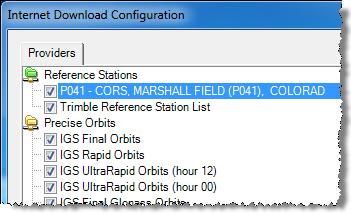
10 Step 5. Download reference station data Note that you can click any column heading to sort the rows based on the column. 5. In the Add Predefined Reference Station Provider dialog, select CORS, MARSHALL FIELD p041 in the list. Then click OK. The site properties for this reference station display in the New Site Properties for Group Reference Stations dialog. You do not need to make any changes. 6. Click OK. The selected provider displays in the Internet Download Configuration dialog. 7. Click OK. Spectra Precision Survey Office Tutorial Importing GNSS Data 10


11 Step 5. Download reference station data The selected provider displays in the Internet Download pane. 8. Double-click P041 CORS, MARSHALL FIELD, or select the station and click the Automatic button at the bottom of the pane. The Download Parameters dialog displays. If the project included multiple time spans, you could select them in the drop-down list. But, since this project has only one time span, you do not need to make a selection. 9. Click OK. A new tab #1 displays in the Internet Download pane, showing the files that are being downloaded and the files ready for import. The action associated with each file is predefined and is displayed in the Action column. You can change any action by selecting it. Note: The log and readme text (.txt) files cannot be imported but they can be saved with the project data. To do this, you would change the action from Delete to Save. 10. Click the Import button on tab #1 to import the time frame. The Receiver Raw Data Check In dialog displays. Typically, you would review the data on all tabs to ensure it is correct. For this tutorial, everything is correct so there is no need to perform this review. 11. Click OK. Spectra Precision Survey Office Tutorial Importing GNSS Data 11
12 Step 6. Download precise orbit data The newly imported reference station data is represented in the Project Explorer pane and on the Plan View. You are now ready to download precise orbit data into your project so that you can process baselines. Step 6. Download precise orbit data To process baselines in your project, you can download and import the precise orbits for the timeframe of the GNSS data. Because the data for this project was collected in the past, you can use the final orbit data when you process the baselines. 1. In the Internet Download pane, double-click IGS Final Orbits. Spectra Precision Survey Office Tutorial Importing GNSS Data 12


13 Step 7. Import a georeferenced image The Download Parameters dialog displays. If the project included multiple time spans, you could select them in the drop-down list. But, since this project has only one time span, you do not need to make a selection. 2. Click OK. The files are displayed for download on the #2 tab. 3. Repeat this procedure for IGS Final Glonass Orbits on the Start tab in the Internet Download pane. 4. In the Internet Download pane, click the Import button on tabs #2 and #3 to import each timeframe. Next, you will import an image that includes georeference data embedded in the image file itself. The image will display in the Plan View based on the global coordinates specified in the georeference data. Note: You can also import an image file that does not include embedded georeference data, but instead uses an associated world georeference data file. The associated file must have the same file name as the georeferenced image, but with a different file extension (for a example,.wld or.ini). Step 7. Import a georeferenced image 1. Select File > Import. Or, click the Import icon on the toolbar. Spectra Precision Survey Office Tutorial Importing GNSS Data 13
14 Step 7. Import a georeferenced image The Import pane opens in the right side of the Spectra Precision Survey Office window. 2. In the Import pane, click the Browse button. 3. In the Browse For Folder dialog, browse to C:\Spectra Precision Tutorials\SPSO\Data\Importing GNSS Data and click OK. The content of the Importing GNSS Data folder displays in the Select File(s) list in the Import pane. 4. In the Select File(s) list, select Westmoore2.tif and click Import. Click No in the Import Errors message dialog. The photo image displays in the Plan View. If the image does not display correctly (for example, the image displays as a black box), you may need to change the display resolution for the image to minimize the amount of memory required to display it. Changing to a lower display resolution will degrade the quality of the image, but it will not change its image size in Plan View. In many cases, you will not even notice the quality change. Since Westmoore2.tif is a very high resolution image, you can change to a lower resolution without losing appreciable quality. Select Tools > Options. In the Options dialog, click the Advanced button. In the Advanced Graphics Options dialog, select the Down-sampled option and select 512x512. Then click OK and OK. 5. Use your mouse wheel to zoom in on the image as shown here. Spectra Precision Survey Office Tutorial Importing GNSS Data 14

15 Step 7. Import a georeferenced image Note that you can select points and baselines, which are now superimposed on the image. By default, the image itself is not selectable in the Plan View. 6. To make the image selectable in the Plan View: a. Select View > View Filter Manager. b. In the View Filter Manager pane, click the Advanced View Filter Settings icon. Spectra Precision Survey Office Tutorial Importing GNSS Data 15

16 Step 7. Import a georeferenced image c. In the Advanced View Filter Settings dialog, select the Selectable checkbox for Georeferenced Image. Then click OK. 7. To view properties for the georeferenced image, click in the upper right corner of the image in the Plan View to select it. Then, right-click and select Properties in the context menu. There are two settings in the Properties pane that can be modified: The View priority setting allows you to select to move the image forward or backward relative to other images in your project by entering a value of 1 to 5 (1 is the most forward, or visible level; 5 is the most backward, or hidden, level). You can also right-click on the image in the Plan View and select a menu option to move it forward or backward. The Visible setting allows you to display or not display the image in the Plan View. You are done importing GNSS data into your project. 8. Select File > Close Project. The Save Changes dialog displays. If you saved the project to a new location or with a new name, you can click Yes. Otherwise, click No. Now that you have imported GNSS data into your project, you are ready to process GNSS baselines. See the tutorial Processing GNSS Baselines for instructions. Spectra Precision Survey Office Tutorial Importing GNSS Data 16
Using Spreadsheets, Selection Sets, and COGO Controls SPECTRA PRECISION SURVEY OFFICE TUTORIAL
 Using Spreadsheets, Selection Sets, and COGO Controls SPECTRA PRECISION SURVEY OFFICE TUTORIAL Corporate office: Spectra Precision 10355 Westmoor Drive Suite #100 Westminster, CO 80021 USA Phone: +1-720-587-4700
Processing Feature Codes SPECTRA PRECISION SURVEY OFFICE TUTORIAL
 Processing Feature Codes SPECTRA PRECISION SURVEY OFFICE TUTORIAL Corporate office: Spectra Precision 10355 Westmoor Drive Suite #100 Westminster, CO 80021 USA Phone: +1-720-587-4700 Toll free (in USA):
How to update FOCUS 30 Firmware
 14 March 2013 How to update FOCUS 30 Firmware This support note will guide you through updating the firmware on a FOCUS 30 instrument. Note : If your FOCUS 30 has previously received a firmware upgrade
Release Notes SPECTRA PRECISION SURVEY OFFICE. Version 3.60
 Release Notes SPECTRA PRECISION SURVEY OFFICE Version 3.60 Corporate office: Spectra Precision 10368 Westmoor Drive Westminster, CO 80021 USA www.spectraprecision.com Copyright and trademarks: 2005-2015,
TABLE OF CONTENTS TABLE OF CONTENTS... 1 INTRODUCTION... 2 USING WORD S MENUS... 3 USING WORD S TOOLBARS... 5 TASK PANE... 9
 TABLE OF CONTENTS TABLE OF CONTENTS... 1 INTRODUCTION... 2 USING WORD S MENUS... 3 DEFINITIONS... 3 WHY WOULD YOU USE THIS?... 3 STEP BY STEP... 3 USING WORD S TOOLBARS... 5 DEFINITIONS... 5 WHY WOULD
Batch Monitor User Manual
 Batch Monitor User Manual You can use the Batch Monitor to view or adjust the status of batches and jobs processed by Compressor or Apple Qmaster. You can also use the Batch Monitor to view detailed history
Faber 6000/Faber 6000 Plus USB Driver Installation for Windows 7/10
 Faber 6000/Faber 6000 Plus USB Driver Installation for Windows 7/10 This guide covers multiple scenarios and only a subset of this guide will affect each user depending on the plotter version and the version
Import, view, edit, convert, and digitize triangulated irregular networks
 v. 10.1 WMS 10.1 Tutorial Import, view, edit, convert, and digitize triangulated irregular networks Objectives Import survey data in an XYZ format. Digitize elevation points using contour imagery. Edit
Numbers Basics Website:
 Website: http://etc.usf.edu/te/ Numbers is Apple's new spreadsheet application. It is installed as part of the iwork suite, which also includes the word processing program Pages and the presentation program
Release Notes SPECTRA PRECISION SURVEY OFFICE. Version
 Release Notes SPECTRA PRECISION SURVEY OFFICE Version 3.90.1 Corporate office: Spectra Precision 10368 Westmoor Drive Westminster, CO 80021 USA www.spectraprecision.com Copyright and trademarks: 2005-2017,
Lesson 4 Customize the ToolBox
 Lesson 4 Customize the ToolBox In this lesson you will learn how to: Change the toolbox to be a Floating toolbox or a toolbox anchored on the Sidebar. Change the combo ToolBox size and highlighting. Change
Developer s Tip Print to Scale Feature in Slide
 Developer s Tip Print to Scale Feature in Slide The latest update to Slide 5.0 brings a number of improvements related to printing functionality, giving the user greater control over printed output. Users
Autodesk Moldflow Insight AMI Getting Started Tutorial
 Autodesk Moldflow Insight 2012 AMI Getting Started Tutorial Revision 1, 30 March 2012. This document contains Autodesk and third-party software license agreements/notices and/or additional terms and conditions
ADOBE TRAINING CS6 PHOTOSHOP BASICS: EDITING PHOTOS & WORKING WITH TEXT - 1
 ADOBE TRAINING CS6 PHOTOSHOP BASICS: EDITING PHOTOS & WORKING WITH TEXT Photoshop is the leading professional software for editing and adjusting photos, images and other graphic projects. It is a very
Post-Processing with MobileMapper Office and NGS CORS data
 Post-Processing with MobileMapper Office and NGS CORS data 23 January 2007 1. Just below the MobileMapper Office (MMO) Map Display Area, you will see the Differential Correction window. Click the Show
Access Review. 4. Save the table by clicking the Save icon in the Quick Access Toolbar or by pulling
 Access Review Relational Databases Different tables can have the same field in common. This feature is used to explicitly specify a relationship between two tables. Values appearing in field A in one table
Mosaic Tutorial: Advanced Workflow
 Mosaic Tutorial: Advanced Workflow This tutorial demonstrates how to mosaic two scenes with different color variations. You will learn how to: Reorder the display of the input scenes Achieve a consistent
Starting Excel application
 MICROSOFT EXCEL 1 2 Microsoft Excel: is a special office program used to apply mathematical operations according to reading a cell automatically, just click on it. It is called electronic tables Starting
Getting Started with Access
 MS Access Chapter 2 Getting Started with Access Course Guide 2 Getting Started with Access The Ribbon The strip across the top of the program window that contains groups of commands is a component of the
TLS Data Processing and Exploration Manual
 Katherine Shervais (UNAVCO), Marin Clark (University of Michigan) Collecting data in the field is only the first step in the complete TLS workflow. This manual will take you through the skills needed to
Word 3 Microsoft Word 2013
 Word 3 Microsoft Word 2013 Mercer County Library System Brian M. Hughes, County Executive Action Technique 1. Insert a Text Box 1. Click the Insert tab on the Ribbon. 2. Then click on Text Box in the Text
Excel Select a template category in the Office.com Templates section. 5. Click the Download button.
 Microsoft QUICK Excel 2010 Source Getting Started The Excel Window u v w z Creating a New Blank Workbook 2. Select New in the left pane. 3. Select the Blank workbook template in the Available Templates
Import and preprocessing of raw spectrum data
 BioNumerics Tutorial: Import and preprocessing of raw spectrum data 1 Aim Comprehensive tools for the import of spectrum data, both raw spectrum data as processed spectrum data are incorporated into BioNumerics.
Creating a Website in Schoolwires Technology Integration Center
 Creating a Website in Schoolwires Technology Integration Center Overview and Terminology... 2 Logging into Schoolwires... 2 Changing a password... 2 Accessing Site Manager... 2 Section Workspace Overview...
XPS1 Automated Multi-Sample Run Procedure
 XPS1 Automated Multi-Sample Run Procedure Follow the XPS Operating Procedure to load samples into the SAC chamber. Once the samples are in the SAC chamber, the following procedure can be used to automate
Getting Started Tutorial
 Getting Started Tutorial V8R1 Copyright Copyright (c) May 2015 IGE-XAO. All rights reserved. No part of this manual, or any portion of it, shall be reproduced, transcribed, saved or translated, under whatever
Objectives Learn how to work with projections in GMS, and how to combine data from different coordinate systems into the same GMS project.
 v. 10.2 GMS 10.2 Tutorial Working with map projections in GMS Objectives Learn how to work with projections in GMS, and how to combine data from different coordinate systems into the same GMS project.
JASCO CANVAS PROGRAM OPERATION MANUAL
 JASCO CANVAS PROGRAM OPERATION MANUAL P/N: 0302-1840A April 1999 Contents 1. What is JASCO Canvas?...1 1.1 Features...1 1.2 About this Manual...1 2. Installation...1 3. Operating Procedure - Tutorial...2
Topcon Link Quick Reference Guide
 Topcon Link Quick Reference Guide Part Number 7040-0027 Rev B Copyright Topcon Positioning Systems, Inc. May, 2003 All contents in this manual are copyrighted by Topcon Positioning Systems, Inc. All rights
Real Monitor and Real Monitor Viewer
 Real Monitor and Real Monitor Viewer This chapter describes Real Monitor and Real Monitor Viewer, two related applications which allow you to collect and review data about your system. These applications
GET TO KNOW FLEXPRO IN ONLY 15 MINUTES
 GET TO KNOW FLEXPRO IN ONLY 15 MINUTES Data Analysis and Presentation Software GET TO KNOW FLEXPRO IN ONLY 15 MINUTES This tutorial provides you with a brief overview of the structure of FlexPro and the
CoSign Quick Guide Virtual Signing with CoSign
 CoSign Quick Guide Virtual Signing with CoSign Table of Contents Launching OmniSign 1 Launching OmniSign with a PDF file 1 Launching OmniSign with a non-pdf file 1 Getting Started with OmniSign 2 Creating
How to Mail Merge PDF Documents
 How to Mail Merge PDF Documents A step-by-step guide to creating personalized documents using AutoMailMerge plug-in for Adobe Acrobat Table of Contents What is a mail merge?...2 What do I need to start?...2
Delegating Access & Managing Another Person s Mail/Calendar with Outlook. Information Technology
 Delegating Access & Managing Another Person s Mail/Calendar with Outlook Information Technology 1. Click the File tab 2. Click Account Settings, and then click Delegate Access 3. Click Add 4. Type the
Nauticom NetEditor: A How-to Guide
 Nauticom NetEditor: A How-to Guide Table of Contents 1. Getting Started 2. The Editor Full Screen Preview Search Check Spelling Clipboard: Cut, Copy, and Paste Undo / Redo Foreground Color Background Color
Microsoft How to Series
 Microsoft How to Series Getting Started with EXCEL 2007 A B C D E F Tabs Introduction to the Excel 2007 Interface The Excel 2007 Interface is comprised of several elements, with four main parts: Office
Discovering Computers & Microsoft Office Office 2010 and Windows 7: Essential Concepts and Skills
 Discovering Computers & Microsoft Office 2010 Office 2010 and Windows 7: Essential Concepts and Skills Objectives Perform basic mouse operations Start Windows and log on to the computer Identify the objects
Using Microsoft Word. Text Editing
 Using Microsoft Word A word processor is all about working with large amounts of text, so learning the basics of text editing is essential to being able to make the most of the program. The first thing
Quick Reference. EMC ApplicationXtender Media Distribution Viewer 5.40 P/N REV A01
 EMC ApplicationXtender Media Distribution Viewer 5.40 Quick Reference P/N 300-005-645 REV A01 EMC Corporation Corporate Headquarters: Hopkinton, MA 01748-9103 1-508-435-1000 www.emc.com Copyright 1994-2007
Chapter 7 Inserting Spreadsheets, Charts, and Other Objects
 Impress Guide Chapter 7 Inserting Spreadsheets, Charts, and Other Objects OpenOffice.org Copyright This document is Copyright 2007 by its contributors as listed in the section titled Authors. You can distribute
Completing Baseline s Site Survey Request Form
 Completing Baseline s Site Survey Request Form The first step in successfully implementing a radio network for your irrigation controllers is to identify the proposed locations for each radio. These radios
Setup a VSN Survey Style Using Trimble Access (Bluetooth Phone)
") Setup a VSN Survey Style Using Trimble Access (Bluetooth Phone) California Surveying & Drafting Supply Technical Support Services Notes: This tutorial is designed as a tutorial for users with a cell phone/vsn
Setup a VSN Survey Style Using Trimble Access (Bluetooth Phone) California Surveying & Drafting Supply Technical Support Services Notes: This tutorial is designed as a tutorial for users with a cell phone/vsn
Tutorial 3 - Performing a Change-Point Analysis in Excel
 Tutorial 3 - Performing a Change-Point Analysis in Excel Introduction This tutorial teaches you how to perform a change-point analysis while using Microsoft Excel. The Change-Point Analyzer Add-In allows
Microsoft Excel 2010 Basic
 Microsoft Excel 2010 Basic Introduction to MS Excel 2010 Microsoft Excel 2010 is a spreadsheet software in the new Microsoft 2010 Office Suite. Excel allows you to store, manipulate and analyze data in
Creating a Crosstab Query in Design View
 Procedures LESSON 31: CREATING CROSSTAB QUERIES Using the Crosstab Query Wizard box, click Crosstab Query Wizard. 5. In the next Crosstab Query the table or query on which you want to base the query. 7.
SchoolDesk University
 SchoolDesk University Forms, Surveys, and Polls Module 101 Guided Walk-through for the basic fields, terminology, and location of tools. What is the NEW SD7 Forms Module? The NEW SchoolDesk Forms Module,
Using ArcPad and GPS Correct 3.31
 Using ArcPad 10.02 and GPS Correct 3.31 Class objectives: Understanding GPS Configuring ArcPad for data collection Field data capture with ArcPad Data collection Navigation Offsets Editing Creating New
Release Notes TRIMBLE BUSINESS CENTER. Version 2.50
 Release Notes TRIMBLE BUSINESS CENTER Version 2.50 Corporate office: Trimble Navigation Limited Engineering and Construction Division 5475 Kellenburger Road Dayton, Ohio 45424-1099 USA Phone: +1-937-233-8921
Table of Contents. Chapter 2. Looking at the Work Area
 Table of Contents... 1 Opening a PDF file in the work area... 2 Working with Acrobat tools and toolbars... 4 Working with Acrobat task buttons... 13 Working with the navigation pane... 14 Review... 18
Logger Pro Resource Sheet
 Logger Pro Resource Sheet Entering and Editing Data Data Collection How to Begin How to Store Multiple Runs Data Analysis How to Scale a Graph How to Determine the X- and Y- Data Points on a Graph How
COMSC-031 Web Site Development- Part 2. Part-Time Instructor: Joenil Mistal
 COMSC-031 Web Site Development- Part 2 Part-Time Instructor: Joenil Mistal Chapter 9 9 Creating Pages with Frames You can divide the display area of a Web browser into multiple panes by creating frames.
Inserting or deleting a worksheet
 Inserting or deleting a worksheet To insert a new worksheet at the end of the existing worksheets, just click the Insert Worksheet tab at the bottom of the screen. To insert a new worksheet before an existing
INTRODUCTION... 1 UNDERSTANDING CELLS... 2 CELL CONTENT... 4
 Introduction to Microsoft Excel 2016 INTRODUCTION... 1 The Excel 2016 Environment... 1 Worksheet Views... 2 UNDERSTANDING CELLS... 2 Select a Cell Range... 3 CELL CONTENT... 4 Enter and Edit Data... 4
Daily Reports Quick Reference Guide
 This topic provides a reference for the Project Center Daily Reports activity center. Purpose Use daily reports to create an official record of the jobsite status and activities for the day. Audience Construction
OpenForms360 Validation User Guide Notable Solutions Inc.
 OpenForms360 Validation User Guide 2011 Notable Solutions Inc. 1 T A B L E O F C O N T EN T S Introduction...5 What is OpenForms360 Validation?... 5 Using OpenForms360 Validation... 5 Features at a glance...
Release Notes SPECTRA PRECISION SURVEY OFFICE. Versions 3.30 (64-bit)
") Release Notes SPECTRA PRECISION SURVEY OFFICE Versions 3.30 (64-bit) Corporate office: Spectra Precision 10368 Westmoor Drive Westminster, CO 80021 USA www.spectraprecision.com Copyright and trademarks:
Release Notes SPECTRA PRECISION SURVEY OFFICE Versions 3.30 (64-bit) Corporate office: Spectra Precision 10368 Westmoor Drive Westminster, CO 80021 USA www.spectraprecision.com Copyright and trademarks:
Supply Chain Guru Network Optimization Tutorial. Version 8.2
 Supply Chain Guru Network Optimization Tutorial Version 8.2 Supply Chain Guru 8.2 Network Optimization Tutorial January 2015 Copyright 2015 LLamasoft, Inc. All Rights Reserved. PC*MILER and ALK are registered
Monitoring and Evaluation Tool
 Monitoring and Evaluation Tool USER MANUAL March, 2014 www.menarid.icarda.org THIS PAGE LEFT EMPTY INTENTIONALLY USER MANUAL Definitions and abbreviations Chart... Graphical representation of M&E project
Day : Date : Objects : Open MS Excel program. Subject : * Open Excel application. Select : start. Choose: programs. Choose : Microsoft Office
 1 2 Day : Date : Objects : Open MS Excel program. Subject : * Open Excel application. Select : start Choose: programs Choose : Microsoft Office Select: Excel * Close the Excel program Click on the Close
Placing Spaces. Let Me Try! Before you begin. The following files are needed for this Let Me Try exercise: M_c04_archi_spaces_rmp2015.
 Placing Spaces Before you begin The following files are needed for this Let Me Try exercise: For Imperial: For Metric: c04_archi_spaces_2016.rvt M_c04_archi_spaces_rmp2015.rvt To access the files from
LAN Modeling. Overview
 LAN Modeling Overview This lesson focuses on the use of LAN models and background link utilization. You will learn to Configure the object palette with the models you need Set up application and profile
Objectives Learn how to work with projections in GMS, and how to combine data from different coordinate systems into the same GMS project.
 v. 10.4 GMS 10.4 Tutorial Working with map projections in GMS Objectives Learn how to work with projections in GMS, and how to combine data from different coordinate systems into the same GMS project.
To complete this database, you will need the following file:
 CHAPTER 2 Access More Skills 13 Create a Multiple Items Form A multiple items form displays records in rows and columns in the same manner as a datasheet. A multiple items form provides more formatting
Week 5 Creating a Calendar. About Tables. Making a Calendar From a Table Template. Week 5 Word 2010
 Week 5 Creating a Calendar About Tables Tables are a good way to organize information. They can consist of only a few cells, or many cells that cover several pages. You can arrange boxes or cells vertically
Placing a Video Call with Zoom PC/Mac
 Placing a Video Call with Zoom PC/Mac Document Outline: To sign up for a PIR Zoom profile and download the Zoom App on any device... p. 1 To search ExpertBook and contact a subject matter expert... p.
Objectives Learn how to work with projections in SMS, and how to combine data from different coordinate systems into the same SMS project.
 v. 12.3 SMS 12.3 Tutorial Working with map projections in SMS Objectives Learn how to work with projections in SMS, and how to combine data from different coordinate systems into the same SMS project.
Microsoft Excel 2010
 Microsoft Excel 2010 omar 2013-2014 First Semester 1. Exploring and Setting Up Your Excel Environment Microsoft Excel 2010 2013-2014 The Ribbon contains multiple tabs, each with several groups of commands.
Trimble s RoadLink Utility Tutorials
 Trimble s RoadLink utility is an interface between third-party road definitions and Trimble survey devices. It lets you import or key in road definitions, view them graphically, edit them if required,
SAPPHIRE Viewer: The Collaboration Tool
 SAPPHIRE Viewer: The Collaboration Tool MiTek SAPPHIRE Viewer is a scaled down version of SAPPHIRE Structure that allows users to open, view, comment on, and print Structure files. This free application
AL-1633/1644 Online Manual Start
 AL-6/6 Online Manual Start Click this "Start" button. Introduction This manual describes the printer and scanner functions of the AL-6/6 digital multifunctional system. For information on the following
Microsoft Office 2016 Mail Merge
 Microsoft Office 2016 Mail Merge Mail Merge Components In order to understand how mail merge works you need to examine the elements involved in the process. In any mail merge, you'll deal with three different
1. Below is an example 1D river reach model built in HEC-RAS and displayed in the HEC-RAS user interface:
 How Do I Import HEC-RAS Cross-Section Data? Flood Modeller allows you to read in cross sections defined in HEC-RAS models, automatically converting them to Flood Modeller 1D cross sections. The procedure
Data Handling and Reports
 Varian Analytical Instruments 2700 Mitchell Drive Walnut Creek, CA 94598-1675/USA Star Chromatography Workstation Version 6 Data Handling and Reports Tutorials Varian, Inc. 2002 03-914736-00:Rev. 4 Trademark
TIBCO Spotfire Lead Discovery 2.1 User s Manual
 TIBCO Spotfire Lead Discovery 2.1 User s Manual Important Information SOME TIBCO SOFTWARE EMBEDS OR BUNDLES OTHER TIBCO SOFTWARE. USE OF SUCH EMBEDDED OR BUNDLED TIBCO SOFTWARE IS SOLELY TO ENABLE THE
Charting Progress with a Spreadsheet
 Charting Progress - 1 Charting Progress with a Spreadsheet We shall use Microsoft Excel to demonstrate how to chart using a spreadsheet. Other spreadsheet programs (e.g., Quattro Pro, Lotus) are similarly
Shape Cluster Photo Written by Steve Patterson
 Shape Cluster Photo Written by Steve Patterson Before After Step 1: Create A New Document Let's begin by creating a new Photoshop document. Go up to the File menu in the Menu Bar along the top of the screen
Open Microsoft Word: click the Start button, click Programs> Microsoft Office> Microsoft Office Word 2007.
 Microsoft Word 2007 Mail Merge Letter The information below is devoted to using Mail Merge to create a letter in Microsoft Word. Please note this is an advanced Word function, you should be comfortable
PowerPoint Slide Basics. Introduction
 PowerPoint 2016 Slide Basics Introduction Every PowerPoint presentation is composed of a series of slides. To begin creating a slide show, you'll need to know the basics of working with slides. You'll
SequencePro Data Analysis Application. User Guide
 SequencePro Data Analysis Application User Guide SequencePro Data Analysis Application User Guide DRAFT October 31, 2001 12:52 pm, Title_page.fm Copyright 2001, Applied Biosystems. All rights reserved.
Microsoft Access 2010
 Microsoft Access 2010 Chapter 2 Querying a Database Objectives Create queries using Design view Include fields in the design grid Use text and numeric data in criteria Save a query and use the saved query
NSCC SUMMER LEARNING SESSIONS MICROSOFT OFFICE SESSION
 NSCC SUMMER LEARNING SESSIONS MICROSOFT OFFICE SESSION Module 1 Using Windows Welcome! Microsoft Windows is an important part of everyday student life. Whether you are logging onto an NSCC computer or
QUICK START GUIDE. SOLO Forest
 QUICK START GUIDE SOLO Forest Software Installation 1. For PC installation, run the.msi file. 2. For Mobile device installation, copy the.cab file onto the device 3. Run the.cab file Starting the Program
Tricking it Out: Tricks to personalize and customize your graphs.
 Tricking it Out: Tricks to personalize and customize your graphs. Graphing templates may be used online without downloading them onto your own computer. However, if you would like to use the templates
Avigilon Gateway Web Client User Guide. Version 6.10
 Avigilon Gateway Web Client User Guide Version 6.10 2006-2018, Avigilon Corporation. All rights reserved. AVIGILON, the AVIGILON logo, AVIGILON CONTROL CENTER, ACC, and TRUSTED SECURITY SOLUTIONS. are
DWG FastView for Web. User Guide
 DWG FastView for Web User Guide Contents 1. Software installation and start-up... 1 1.1 Software installation... 1 1.2 Software start-up... 1 2.Operation interface and functions... 3 2.1 Operation interface...
Setup a VSN Survey Style Using Trimble Access (MiFi Card)
") Setup a VSN Survey Style Using Trimble Access (MiFi Card) California Surveying & Drafting Supply Technical Support Services Notes: This tutorial is designed for users with a MiFi Card/VSN Setup. In order
Setup a VSN Survey Style Using Trimble Access (MiFi Card) California Surveying & Drafting Supply Technical Support Services Notes: This tutorial is designed for users with a MiFi Card/VSN Setup. In order
SMART Recorder. Record. Pause. Stop
 SMART Recorder The recorder is used to record actions that are done on the interactive screen. If a microphone is attached to the computer, narration can be recorded. After the recording has been created,
Objectives Learn how free online map data can quickly and easily be used to dynamically update background maps and aerial photography in GMS.
 v. 10.4 GMS 10.4 Tutorial Using free, dynamic, online map data in GMS Objectives Learn how free online map data can quickly and easily be used to dynamically update background maps and aerial photography
OnCOR Silverlight Viewer Guide
 Getting Around There are many ways to move around the map! The simplest option is to use your mouse in the map area. If you hold the left button down, then click and drag, you can pan the map to a new
FastTrack Schedule 10. Tutorials. Copyright 2010, AEC Software, Inc. All rights reserved.
 FastTrack Schedule 10 Tutorials FastTrack Schedule Tutorials Version 10.0.0 by Carol S. Williamson AEC Software, Inc. With FastTrack Schedule 10, the new version of the award-winning project manager,
Out of the Office and Into the Field: Introduction to ArcPad and ArcPad Application Builder
 Out of the Office and Into the Field: Introduction to ArcPad and ArcPad Application Builder A Yale Map Collection GIS Workshop Preparing For the Tutorial 1. Navigate to the C:\Temp folder on your harddrive.
FRC Team 1511 Scouting System Setup and Use
 FRC Team 1511 Scouting System Setup and Use Revision History NOTE: when you add/change the Version and/or Date, be sure to update the header on the next page Version Date Author Description 1.0 2/10/14
Microsoft Excel 2007
 Microsoft Excel 2007 1 Excel is Microsoft s Spreadsheet program. Spreadsheets are often used as a method of displaying and manipulating groups of data in an effective manner. It was originally created
VisualPST 2.4. Visual object report editor for PowerSchool. Copyright Park Bench Software, LLC All Rights Reserved
 VisualPST 2.4 Visual object report editor for PowerSchool Copyright 2004-2015 Park Bench Software, LLC All Rights Reserved www.parkbenchsoftware.com This software is not free - if you use it, you must
Objectives Learn how free online map data can quickly and easily be used to dynamically update background maps and aerial photography in GMS.
 v. 10.3 GMS 10.3 Tutorial Using free, dynamic, online map data in GMS Objectives Learn how free online map data can quickly and easily be used to dynamically update background maps and aerial photography
Microsoft Access 2013
 Microsoft Access 2013 Chapter 2 Querying a Database Objectives Create queries using Design view Include fields in the design grid Use text and numeric data in criteria Save a query and use the saved query
Microsoft Access 2013
 Microsoft Access 2013 Chapter 2 Querying a Database Objectives Create queries using Design view Include fields in the design grid Use text and numeric data in criteria Save a query and use the saved query
NETWORK PRINT MONITOR User Guide
 NETWORK PRINT MONITOR User Guide Legal Notes Unauthorized reproduction of all or part of this guide is prohibited. The information in this guide is subject to change for improvement without notice. We
Legal Notes. Regarding Trademarks KYOCERA MITA Corporation
 Legal Notes Unauthorized reproduction of all or part of this guide is prohibited. The information in this guide is subject to change without notice. We cannot be held liable for any problems arising from
GPS Pathfinder Office Software and the GPS Analyst Extension: Creating User-defined Base Providers
 26 January 2010 GPS Pathfinder Office Software and the GPS Analyst Extension: Creating User-defined Base Providers This support note provides instructions for setting up a user-defined base provider in