National Science Foundation Engineering Research Center. Bingcai Zhang BAE Systems San Diego, CA
|
|
|
- Melvin Hines
- 5 years ago
- Views:
Transcription

1 Bingcai Zhang BAE Systems San Diego, CA
2 Introduction It is a trivial task for a five-year-old child to recognize and name an object such as a car, house or building. However, it is a challenging software problem to identify and label these same objects automatically in a digital image. Geospatial information technology such as digital photogrammetry can answer the where question accurately. The next breakthrough may be the what question, which is to identify and label objects automatically in digital imagery. Automatic 3-D building extraction from digital imagery is considered the Holy Grail in photogrammetry. It is very difficult to automatically extract buildings from images using only their radiometric properties. 2
3 Introduction continued In the past three decades, many algorithms have been developed to extract 3-D buildings from a very specific set of digital images Until now, there has not been a commercial software package that can reliably do this We show the results of automatically identifying objects such as houses and buildings, including the relationships between DSM accuracy and post spacing, and size requirements for automatically extracting and labeling objects 3


4 Radiometry vs. 3-D shapes Six different building colors and patterns Very difficult to extract buildings based on radiometric properties only Terrain shaded relief of digital surface model generated by NGATE The locations and approximate shapes of the buildings are obvious 4
5 Next-Generation Photogrammetry Automation System The two most important technologies in modern photogrammetry are sensor modeling and automation. Sensor modeling provides accurate measurements and automation for terrain generation, while 3-D building extraction increases productivity. 5
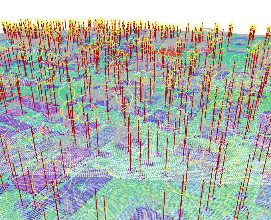
6 Technical approach Automatic transformation from LIDAR point cloud to bare-earth model Bare-Earth Profile Bare-Earth Morphology Bare-Earth Histogram Bare-Earth Dense Tree Canopy Identify and group 3-D object points into regions Separate buildings and houses from trees Trace region boundaries Regularize and simplify boundary polygons Construct complex roofs 6
7 Sample results: Case study one LIDAR data with a post spacing of 0.2 meters was converted to a GRID format with a post spacing of 0.1 meters The following building parameters were used: 1. Minimum height 2 meters 2. Minimum width 5 meters 3. Maximum width 200 meters 4. Roof detail 0.4 meters 5. Enforce building squaring on AFE transforms a GRID DSM into a GRID DEM using parameters 1, 2 and 3 as the first step 59 buildings and 13 trees extracted 7

8 Sample results: Case study one continued 8

9 Sample results: Case study one continued A complex building, with more than 50 sides, automatically extracted by AFE from LIDAR 9
10 Sample results: Case study one continued To determine the accuracy of automatically extracted building boundaries, we compare segment deltas of the same building boundary extracted by a human operator using photogrammetric stereo images. The stereo images have a pixel resolution of GSD 0.07 meters. Therefore, we can consider the manually extracted building boundary as ground truth for our accuracy analysis. The RMSE is about 0.2 meters or one post spacing. 3-D slant 2-D XY Elevation length delta length delta delta Max Mean RMSE
11 Sample Results: Case study two LIDAR data provided by USC s Integrated Media Systems Center (IMSC) with average post spacing of 0.4 meters 138 million posts covering a relatively flat area with many trees The following building parameters were used: 1. Minimum height 2 meters 2. Minimum width 3 meters 3. Maximum width 300 meters 4. Roof detail of 0.4 meters 5. Enforce building squaring on 2464 buildings and houses extracted 5164 trees extracted. 1.2 hours to complete (four 3 GHZ CPUs with debugging code) 11

12 Sample Results: Case study two continued Terrain shaded relief of 24.8 square kilometers 12

13 Sample Results: Case study two continued 13

14 Sample results: Case study two continued 14

15 Sample Results: Case study two continued 15

16 Sample results: Case study two continued 16
17 3-D flythrough 17


18 Potential applications Data fusion between LIDAR and other types of data such as EO images Registering existing 3-D site models from EO images to LIDAR 3-D site models When LIDAR is much more accurate, this improves the EO sensor parameters Robotics and UAV/UGV applications Make it real-time to navigate a robot Fighting vehicle (navigate and recognize target) 18
19 Conclusions Automatically identifying, extracting, and labeling 3-D buildings from dense digital surface models by using their invariant 3-D properties can be achieved to a production level capability. Unlike automatic terrain generation systems, which are very mature and have been used widely for two decades, the commercial production level automatic 3-D building extraction system is in its infancy. Our research and development indicates that we can automatically label 3- D buildings by applying advanced stereo image matching technology and LIDAR, automatic bare-earth transformation from DSM, and 3-D buildings invariant 3-D properties. For precise GIS cartographic mapping, manual digitizing should still be used. For fast and affordable 3-D modeling, simulation, and visualization, where accuracy is not as important as affordability and speed, automation technology, such as AFE, may soon gain user acceptance. 19
20 Thanks!
3-D OBJECT RECOGNITION FROM POINT CLOUD DATA
 3-D OBJECT RECOGNITION FROM POINT CLOUD DATA W. Smith, A.S. Walker, B. Zhang BAE Systems, San Diego, CA 92127, USA (william.smith4, stewart.walker2, bingcai.zhang)@baesystems.com KEY WORDS: Automation,
GPU-accelerated 3-D point cloud generation from stereo images
 GPU-accelerated 3-D point cloud generation from stereo images Dr. Bingcai Zhang Release of this guide is approved as of 02/28/2014. This document gives only a general description of the product(s) or service(s)
AUTOMATIC TERRAIN EXTRACTION USING MULTIPLE IMAGE PAIR AND BACK MATCHING INTRODUCTION
 AUTOMATIC TERRAIN EXTRACTION USING MULTIPLE IMAGE PAIR AND BACK MATCHING Bingcai Zhang, Chief Photogrammetrist Scott Miller, Chief Engineer Kurt DeVenecia, Product Manager Stewart Walker, Director of Marketing
Lidar and GIS: Applications and Examples. Dan Hedges Clayton Crawford
 Lidar and GIS: Applications and Examples Dan Hedges Clayton Crawford Outline Data structures, tools, and workflows Assessing lidar point coverage and sample density Creating raster DEMs and DSMs Data area
Presented at the FIG Congress 2018, May 6-11, 2018 in Istanbul, Turkey
 Presented at the FIG Congress 2018, May 6-11, 2018 in Istanbul, Turkey Evangelos MALTEZOS, Charalabos IOANNIDIS, Anastasios DOULAMIS and Nikolaos DOULAMIS Laboratory of Photogrammetry, School of Rural
CO-REGISTERING AND NORMALIZING STEREO-BASED ELEVATION DATA TO SUPPORT BUILDING DETECTION IN VHR IMAGES
 CO-REGISTERING AND NORMALIZING STEREO-BASED ELEVATION DATA TO SUPPORT BUILDING DETECTION IN VHR IMAGES Alaeldin Suliman, Yun Zhang, Raid Al-Tahir Department of Geodesy and Geomatics Engineering, University
A COMPARISON OF LIDAR TERRAIN DATA WITH AUTOCORRELATED DSM EXTRACTED FROM DIGITALLY ACQUIRED HIGH OVERLAP PHOTOGRAPHY BACKGROUND
 A COMPARISON OF LIDAR TERRAIN DATA WITH AUTOCORRELATED DSM EXTRACTED FROM DIGITALLY ACQUIRED HIGH OVERLAP PHOTOGRAPHY Devin Kelley, Project Manager, Certified Photogrammetrist (ASPRS) Thomas Loecherbach,
Automated Extraction of Buildings from Aerial LiDAR Point Cloud and Digital Imaging Datasets for 3D Cadastre - Preliminary Results
 Automated Extraction of Buildings from Aerial LiDAR Point Cloud and Digital Imaging Datasets for 3D Pankaj Kumar 1*, Alias Abdul Rahman 1 and Gurcan Buyuksalih 2 ¹Department of Geoinformation Universiti
N.J.P.L.S. An Introduction to LiDAR Concepts and Applications
 N.J.P.L.S. An Introduction to LiDAR Concepts and Applications Presentation Outline LIDAR Data Capture Advantages of Lidar Technology Basics Intensity and Multiple Returns Lidar Accuracy Airborne Laser
Training i Course Remote Sensing Basic Theory & Image Processing Methods September 2011
 Training i Course Remote Sensing Basic Theory & Image Processing Methods 19 23 September 2011 Geometric Operations Michiel Damen (September 2011) damen@itc.nl ITC FACULTY OF GEO-INFORMATION SCIENCE AND
EVALUATION OF WORLDVIEW-1 STEREO SCENES AND RELATED 3D PRODUCTS
 EVALUATION OF WORLDVIEW-1 STEREO SCENES AND RELATED 3D PRODUCTS Daniela POLI, Kirsten WOLFF, Armin GRUEN Swiss Federal Institute of Technology Institute of Geodesy and Photogrammetry Wolfgang-Pauli-Strasse
2010 LiDAR Project. GIS User Group Meeting June 30, 2010
 2010 LiDAR Project GIS User Group Meeting June 30, 2010 LiDAR = Light Detection and Ranging Technology that utilizes lasers to determine the distance to an object or surface Measures the time delay between
Reality Check: Processing LiDAR Data. A story of data, more data and some more data
 Reality Check: Processing LiDAR Data A story of data, more data and some more data Red River of the North Red River of the North Red River of the North Red River of the North Introduction and Background
Should Contours Be Generated from Lidar Data, and Are Breaklines Required? Lidar data provides the most
 Should Contours Be Generated from Lidar Data, and Are Breaklines Required? Lidar data provides the most accurate and reliable representation of the topography of the earth. As lidar technology advances
Terrain Modeling and Mapping for Telecom Network Installation Using Scanning Technology. Maziana Muhamad
 Terrain Modeling and Mapping for Telecom Network Installation Using Scanning Technology Maziana Muhamad Summarising LiDAR (Airborne Laser Scanning) LiDAR is a reliable survey technique, capable of: acquiring
DIGITAL SURFACE MODELS OF CITY AREAS BY VERY HIGH RESOLUTION SPACE IMAGERY
 DIGITAL SURFACE MODELS OF CITY AREAS BY VERY HIGH RESOLUTION SPACE IMAGERY Jacobsen, K. University of Hannover, Institute of Photogrammetry and Geoinformation, Nienburger Str.1, D30167 Hannover phone +49
[Youn *, 5(11): November 2018] ISSN DOI /zenodo Impact Factor
![[Youn *, 5(11): November 2018] ISSN DOI /zenodo Impact Factor](/thumbs/91/105079225.jpg "[Youn *, 5(11): November 2018] ISSN DOI /zenodo Impact Factor") GLOBAL JOURNAL OF ENGINEERING SCIENCE AND RESEARCHES AUTOMATIC EXTRACTING DEM FROM DSM WITH CONSECUTIVE MORPHOLOGICAL FILTERING Junhee Youn *1 & Tae-Hoon Kim 2 *1,2 Korea Institute of Civil Engineering
GLOBAL JOURNAL OF ENGINEERING SCIENCE AND RESEARCHES AUTOMATIC EXTRACTING DEM FROM DSM WITH CONSECUTIVE MORPHOLOGICAL FILTERING Junhee Youn *1 & Tae-Hoon Kim 2 *1,2 Korea Institute of Civil Engineering
2017 PROGRAM OVERVIEW. Geospatial Intelligence for Better Outcomes
 2017 PROGRAM OVERVIEW Geospatial Intelligence for Better Outcomes NICB SOLUTION : GEOSPATIAL INTELLIGENCE CENTER Key Program Areas 1. CAT / Disaster Response 2. National Imagery Program 3. Digital Delivery
UTILIZACIÓN DE DATOS LIDAR Y SU INTEGRACIÓN CON SISTEMAS DE INFORMACIÓN GEOGRÁFICA
 UTILIZACIÓN DE DATOS LIDAR Y SU INTEGRACIÓN CON SISTEMAS DE INFORMACIÓN GEOGRÁFICA Aurelio Castro Cesar Piovanetti Geographic Mapping Technologies Corp. (GMT) Consultores en GIS info@gmtgis.com Geographic
VALIDATION OF A NEW 30 METER GROUND SAMPLED GLOBAL DEM USING ICESAT LIDARA ELEVATION REFERENCE DATA
 VALIDATION OF A NEW 30 METER GROUND SAMPLED GLOBAL DEM USING ICESAT LIDARA ELEVATION REFERENCE DATA M. Lorraine Tighe Director, Geospatial Solutions Intermap Session: Photogrammetry & Image Processing
Alaska Department of Transportation Roads to Resources Project LiDAR & Imagery Quality Assurance Report Juneau Access South Corridor
 Alaska Department of Transportation Roads to Resources Project LiDAR & Imagery Quality Assurance Report Juneau Access South Corridor Written by Rick Guritz Alaska Satellite Facility Nov. 24, 2015 Contents
Esri International User Conference. July San Diego Convention Center. Lidar Solutions. Clayton Crawford
 Esri International User Conference July 23 27 San Diego Convention Center Lidar Solutions Clayton Crawford Outline Data structures, tools, and workflows Assessing lidar point coverage and sample density
AIRBORNE GEIGER MODE LIDAR - LATEST ADVANCEMENTS IN REMOTE SENSING APPLICATIONS RANDY RHOADS
 Place image here (10 x 3.5 ) AIRBORNE GEIGER MODE LIDAR - LATEST ADVANCEMENTS IN REMOTE SENSING APPLICATIONS RANDY RHOADS Geospatial Industry Manager HARRIS.COM #HARRISCORP Harris Company Information SECURITY
New Features in SOCET SET Stewart Walker, San Diego, USA
 New Features in SOCET SET Stewart Walker, San Diego, USA 2610083107A EXPORT CONTROL DATA. This presentation is approved for export as of 31 August 2007. The actual product and its technical information
AUTOMATED 3-D FEATURE EXTRACTION FROM TERRESTRIAL AND AIRBORNE LIDAR
 AUTOMATED 3-D FEATURE EXTRACTION FROM TERRESTRIAL AND AIRBORNE LIDAR D. W. Opitz, R. Rao, J. S. Blundell Visual Learning Systems, Inc., 1719 Dearborn, Missoula, Montana 59801 USA opitz@vls-inc.com, rrao@vls-inc.com
HEURISTIC FILTERING AND 3D FEATURE EXTRACTION FROM LIDAR DATA
 HEURISTIC FILTERING AND 3D FEATURE EXTRACTION FROM LIDAR DATA Abdullatif Alharthy, James Bethel School of Civil Engineering, Purdue University, 1284 Civil Engineering Building, West Lafayette, IN 47907
3D CITY MODELLING WITH CYBERCITY-MODELER
 1 3D CITY MODELLING WITH CYBERCITY-MODELER Kilian Ulm 1 and Daniela Poli 1 1. CyberCity AG, Zurich, Switzerland, (kilian.ulm, daniela.poli)@cybercity.tv ABSTRACT 3D city models using stereo aerial-/satellite
TrueOrtho with 3D Feature Extraction
 TrueOrtho with 3D Feature Extraction PCI Geomatics has entered into a partnership with IAVO to distribute its 3D Feature Extraction (3DFE) software. This software package compliments the TrueOrtho workflow
Files Used in this Tutorial
 Generate Point Clouds and DSM Tutorial This tutorial shows how to generate point clouds and a digital surface model (DSM) from IKONOS satellite stereo imagery. You will view the resulting point clouds
Topographic Lidar Data Employed to Map, Preserve U.S. History
 OCTOBER 11, 2016 Topographic Lidar Data Employed to Map, Preserve U.S. History In August 2015, the National Park Service (NPS) contracted Woolpert for the Little Bighorn National Monument Mapping Project
AUTOMATIC BUILDING DETECTION FROM LIDAR POINT CLOUD DATA
 AUTOMATIC BUILDING DETECTION FROM LIDAR POINT CLOUD DATA Nima Ekhtari, M.R. Sahebi, M.J. Valadan Zoej, A. Mohammadzadeh Faculty of Geodesy & Geomatics Engineering, K. N. Toosi University of Technology,
1. Introduction. A CASE STUDY Dense Image Matching Using Oblique Imagery Towards All-in- One Photogrammetry
 Submitted to GIM International FEATURE A CASE STUDY Dense Image Matching Using Oblique Imagery Towards All-in- One Photogrammetry Dieter Fritsch 1, Jens Kremer 2, Albrecht Grimm 2, Mathias Rothermel 1
SPOT-1 stereo images taken from different orbits with one month difference
 DSM Generation Almost all HR sensors are stereo capable. Some can produce even triplettes within the same strip (facilitating multi-image matching). Mostly SPOT (1-5) used for stereo and Ikonos (in spite
I. Project Title Light Detection and Ranging (LIDAR) Processing
 Processing") I. Project Title Light Detection and Ranging (LIDAR) Processing II. Lead Investigator Ryan P. Lanclos Research Specialist 107 Stewart Hall Department of Geography University of Missouri Columbia Columbia,
I. Project Title Light Detection and Ranging (LIDAR) Processing II. Lead Investigator Ryan P. Lanclos Research Specialist 107 Stewart Hall Department of Geography University of Missouri Columbia Columbia,
BUILDING DETECTION AND STRUCTURE LINE EXTRACTION FROM AIRBORNE LIDAR DATA
 BUILDING DETECTION AND STRUCTURE LINE EXTRACTION FROM AIRBORNE LIDAR DATA C. K. Wang a,, P.H. Hsu a, * a Dept. of Geomatics, National Cheng Kung University, No.1, University Road, Tainan 701, Taiwan. China-
GEOGRAPHIC INFORMATION SYSTEMS Lecture 25: 3D Analyst
 GEOGRAPHIC INFORMATION SYSTEMS Lecture 25: 3D Analyst 3D Analyst - 3D Analyst is an ArcGIS extension designed to work with TIN data (triangulated irregular network) - many of the tools in 3D Analyst also
Digital Elevation Models (DEM)
") Digital Elevation Models (DEM) Digital representation of the terrain surface also referred to as Digital Terrain Models (DTM) Digital Elevation Models (DEM) How has relief depiction changed with digital
Digital Elevation Models (DEM) Digital representation of the terrain surface also referred to as Digital Terrain Models (DTM) Digital Elevation Models (DEM) How has relief depiction changed with digital
Algorithms for GIS csci3225
 Algorithms for GIS csci3225 Laura Toma Bowdoin College LiDAR data in GIS LiDAR (Light Detection and Ranging) Each point records: its geographic location x,y its height z the number of returns in its pulse
LiDAR Applications. Examples of LiDAR applications. forestry hydrology geology urban applications
 LiDAR Applications Examples of LiDAR applications forestry hydrology geology urban applications 1 Forestry applications canopy heights individual tree and crown mapping estimated DBH and leaf area index
What s New in Imagery in ArcGIS. Presented by: Christopher Patterson Date: October 18, 2017
 What s New in Imagery in ArcGIS Presented by: Christopher Patterson Date: October 18, 2017 Imagery in ArcGIS Advancing 2010 Stretch, Extract Bands Clip, Mask Reproject, Orthorectify, Pan Sharpen Vegetation
AUTOMATIC EXTRACTION OF BUILDING OUTLINE FROM HIGH RESOLUTION AERIAL IMAGERY
 AUTOMATIC EXTRACTION OF BUILDING OUTLINE FROM HIGH RESOLUTION AERIAL IMAGERY Yandong Wang EagleView Technology Cor. 5 Methodist Hill Dr., Rochester, NY 1463, the United States yandong.wang@ictometry.com
Improving wide-area DEMs through data fusion - chances and limits
 Improving wide-area DEMs through data fusion - chances and limits Konrad Schindler Photogrammetry and Remote Sensing, ETH Zürich How to get a DEM for your job? for small projects (or rich people) contract
Bonemapping: A LiDAR Processing and Visualization Approach and Its Applications
 Bonemapping: A LiDAR Processing and Visualization Approach and Its Applications Thomas J. Pingel Northern Illinois University National Geography Awareness Week Lecture Department of Geology and Geography
Light Detection and Ranging (LiDAR)
") Light Detection and Ranging (LiDAR) http://code.google.com/creative/radiohead/ Types of aerial sensors passive active 1 Active sensors for mapping terrain Radar transmits microwaves in pulses determines
Light Detection and Ranging (LiDAR) http://code.google.com/creative/radiohead/ Types of aerial sensors passive active 1 Active sensors for mapping terrain Radar transmits microwaves in pulses determines
Visualizing 2D Data in a 3D World
 Visualizing 2D Data in a 3D World Karl Kliparchuk, M.Sc., GISP, and Brendan Walashek, B.Sc. McElhanney Consulting Services Ltd. Email: kkliparchuk@mcelhanney.com and bwalashek@mcelhanney.com Agenda A Quick
Representing Geography
 Data models and axioms Chapters 3 and 7 Representing Geography Road map Representing the real world Conceptual models: objects vs fields Implementation models: vector vs raster Vector topological model
An Introduction to Lidar & Forestry May 2013
 An Introduction to Lidar & Forestry May 2013 Introduction to Lidar & Forestry Lidar technology Derivatives from point clouds Applied to forestry Publish & Share Futures Lidar Light Detection And Ranging
a Geo-Odyssey of UAS LiDAR Mapping Henno Morkel UAS Segment Specialist DroneCon 17 May 2018
 a Geo-Odyssey of UAS LiDAR Mapping Henno Morkel UAS Segment Specialist DroneCon 17 May 2018 Abbreviations UAS Unmanned Aerial Systems LiDAR Light Detection and Ranging UAV Unmanned Aerial Vehicle RTK Real-time
Creating raster DEMs and DSMs from large lidar point collections. Summary. Coming up with a plan. Using the Point To Raster geoprocessing tool
 Page 1 of 5 Creating raster DEMs and DSMs from large lidar point collections ArcGIS 10 Summary Raster, or gridded, elevation models are one of the most common GIS data types. They can be used in many ways
3D Analyst Visualization with ArcGlobe. Brady Hoak, ESRI DC
 3D Analyst Visualization with ArcGlobe Brady Hoak, ESRI DC 3D GIS Viewing geospatial data in 3D leads to new insights 2D 3D Sometimes you need to edit your data in 3D 2D 3D Some problems can only be solved
DEVELOPMENT OF ORIENTATION AND DEM/ORTHOIMAGE GENERATION PROGRAM FOR ALOS PRISM
 DEVELOPMENT OF ORIENTATION AND DEM/ORTHOIMAGE GENERATION PROGRAM FOR ALOS PRISM Izumi KAMIYA Geographical Survey Institute 1, Kitasato, Tsukuba 305-0811 Japan Tel: (81)-29-864-5944 Fax: (81)-29-864-2655
Outline of Presentation. Introduction to Overwatch Geospatial Software Feature Analyst and LIDAR Analyst Software
 Outline of Presentation Automated Feature Extraction from Terrestrial and Airborne LIDAR Presented By: Stuart Blundell Overwatch Geospatial - VLS Ops Co-Author: David W. Opitz Overwatch Geospatial - VLS
Overview of the Trimble TX5 Laser Scanner
 Overview of the Trimble TX5 Laser Scanner Trimble TX5 Revolutionary and versatile scanning solution Compact / Lightweight Efficient Economical Ease of Use Small and Compact Smallest and most compact 3D
DENSE 3D POINT CLOUD GENERATION FROM UAV IMAGES FROM IMAGE MATCHING AND GLOBAL OPTIMAZATION
 DENSE 3D POINT CLOUD GENERATION FROM UAV IMAGES FROM IMAGE MATCHING AND GLOBAL OPTIMAZATION S. Rhee a, T. Kim b * a 3DLabs Co. Ltd., 100 Inharo, Namgu, Incheon, Korea ahmkun@3dlabs.co.kr b Dept. of Geoinformatic
EVALUATION OF WORLDVIEW-1 STEREO SCENES
 EVALUATION OF WORLDVIEW-1 STEREO SCENES Daniela Poli a, Kirsten Wolff b, Armin Gruen b a. European Commission, JRC, via Fermi 2749, Ispra (VA), Italy - daniela.poli@cec.europa.eu b. Swiss Federal Institute
MODULE 1 BASIC LIDAR TECHNIQUES
 MODULE SCENARIO One of the first tasks a geographic information systems (GIS) department using lidar data should perform is to check the quality of the data delivered by the data provider. The department
FILTERING OF DIGITAL ELEVATION MODELS
 FILTERING OF DIGITAL ELEVATION MODELS Dr. Ing. Karsten Jacobsen Institute for Photogrammetry and Engineering Survey University of Hannover, Germany e-mail: jacobsen@ipi.uni-hannover.de Dr. Ing. Ricardo
DIGITAL SURFACE MODELS IN BUILD UP AREAS BASED ON VERY HIGH RESOLUTION SPACE IMAGES
 DIGITAL SURFACE MODELS IN BUILD UP AREAS BASED ON VERY HIGH RESOLUTION SPACE IMAGES Gurcan Buyuksalih*, Karsten Jacobsen** *BIMTAS, Tophanelioglu Cad. ISKI Hizmet Binasi No:62 K.3-4 34460 Altunizade-Istanbul,
An Introduction to Using Lidar with ArcGIS and 3D Analyst
 FedGIS Conference February 24 25, 2016 Washington, DC An Introduction to Using Lidar with ArcGIS and 3D Analyst Jim Michel Outline Lidar Intro Lidar Management Las files Laz, zlas, conversion tools Las
THE USE OF ANISOTROPIC HEIGHT TEXTURE MEASURES FOR THE SEGMENTATION OF AIRBORNE LASER SCANNER DATA
 THE USE OF ANISOTROPIC HEIGHT TEXTURE MEASURES FOR THE SEGMENTATION OF AIRBORNE LASER SCANNER DATA Sander Oude Elberink* and Hans-Gerd Maas** *Faculty of Civil Engineering and Geosciences Department of
BUILDING EXTRACTION FROM LIDAR USING EDGE DETECTION
 Committee: BUILDING EXTRACTION FROM LIDAR USING EDGE DETECTION by Justin Miller A Thesis Submitted to the Graduate Faculty of George Mason University in Partial Fulfillment of The Requirements for the
EVOLUTION OF POINT CLOUD
 Figure 1: Left and right images of a stereo pair and the disparity map (right) showing the differences of each pixel in the right and left image. (source: https://stackoverflow.com/questions/17607312/difference-between-disparity-map-and-disparity-image-in-stereo-matching)
New Requirements for the Relief in the Topographic Databases of the Institut Cartogràfic de Catalunya
 New Requirements for the Relief in the Topographic Databases of the Institut Cartogràfic de Catalunya Blanca Baella, Maria Pla Institut Cartogràfic de Catalunya, Barcelona, Spain Abstract Since 1983 the
REMOTE SENSING LiDAR & PHOTOGRAMMETRY 19 May 2017
 REMOTE SENSING LiDAR & PHOTOGRAMMETRY 19 May 2017 SERVICES Visual Inspections Digital Terrain Models Aerial Imagery Volume Computations Thermal Inspections Photo maps Aerial Video Training & Consultancy
Digital photogrammetry project with very high-resolution stereo pairs acquired by DigitalGlobe, Inc. satellite Worldview-2
 White PAPER Greater area of the City of La Paz, Bolivia Digital photogrammetry project with very high-resolution stereo pairs acquired by DigitalGlobe, Inc. satellite Worldview-2 By: Engineers Nelson Mattie,
8 Geographers Tools: Automated Mapping. Digitizing a Map IMPORTANT 2/19/19. v Tues., Feb. 26, 2019.
 Next Class: FIRST EXAM v Tues., Feb. 26, 2019. Combination of multiple choice questions and map interpretation. Bring a #2 pencil with eraser. Based on class lectures supplementing Chapter 1. Review lectures
DSM GENERATION FROM EARLY ALOS/PRISM DATA USING SAT-PP
 DSM GENERATION FROM EARLY ALOS/PRISM DATA USING SAT-PP K. Wolff, A. Gruen Institute of Geodesy and Photogrammetry, ETH-Zurich, CH-8093 Zurich, Switzerland @geod.baug.ethz.ch KEY WORDS: PRISM
Digital Elevation Models (DEMs)
") Digital Elevation Models (DEM) - Terrain Models (DTM) How has relief depiction on maps and online changed with digital mapping/ GIS?.. Perhaps more than the other map elements / layers Digital Elevation
Digital Elevation Models (DEM) - Terrain Models (DTM) How has relief depiction on maps and online changed with digital mapping/ GIS?.. Perhaps more than the other map elements / layers Digital Elevation
The Feature Analyst Extension for ERDAS IMAGINE
 The Feature Analyst Extension for ERDAS IMAGINE Automated Feature Extraction Software for GIS Database Maintenance We put the information in GIS SM A Visual Learning Systems, Inc. White Paper September
Comparison of LiDAR and Stereo Photogrammetric Point Clouds for Change Detection Paul L Basgall a, Fred A Kruse b, Richard C Olsen b
 Comparison of LiDAR and Stereo Photogrammetric Point Clouds for Change Detection Paul L Basgall a, Fred A Kruse b, Richard C Olsen b a National Geospatial Intelligence Agency, 3838 Vogel Road, Arnold,
SimActive and PhaseOne Workflow case study. By François Riendeau and Dr. Yuri Raizman Revision 1.0
 SimActive and PhaseOne Workflow case study By François Riendeau and Dr. Yuri Raizman Revision 1.0 Contents 1. Introduction... 2 1.1. Simactive... 2 1.2. PhaseOne Industrial... 2 2. Testing Procedure...
8 Geographers Tools: Automated Mapping. Digitizing a Map 2/19/19 IMPORTANT. Revising a Digitized Map. The Digitized Map. vtues., Feb. 26, 2019.
 Next Class: FIRST EXAM 8 Geographers Tools: Automated Mapping vtues., Feb. 26, 2019. Combination of multiple choice questions and map interpretation. Bring a #2 pencil with eraser. Based on class lectures
Photogrammetric Performance of an Ultra Light Weight Swinglet UAV
 Photogrammetric Performance of an Ultra Light Weight Swinglet UAV J. Vallet, F. Panissod, C. Strecha, M. Tracol UAV-g 2011 - Unmanned Aerial Vehicle in Geomatics September 14-16, 2011ETH Zurich Summary
CORRECTING DEM EXTRACTED FROM ASTER STEREO IMAGES BY COMBINING CARTOGRAPHIC DEM
 CORRECTING DEM EXTRACTED FROM ASTER STEREO IMAGES BY COMBINING CARTOGRAPHIC DEM Jin-Duk Lee a, *, Seung-Hee Han b, Sung-Soon Lee c, Jin-Sung Park d a School of Civil and Environmental Engineering, Kumoh
A DATA DRIVEN METHOD FOR FLAT ROOF BUILDING RECONSTRUCTION FROM LiDAR POINT CLOUDS
 A DATA DRIVEN METHOD FOR FLAT ROOF BUILDING RECONSTRUCTION FROM LiDAR POINT CLOUDS A. Mahphood, H. Arefi *, School of Surveying and Geospatial Engineering, College of Engineering, University of Tehran,
SOME stereo image-matching methods require a user-selected
 IEEE GEOSCIENCE AND REMOTE SENSING LETTERS, VOL. 3, NO. 2, APRIL 2006 207 Seed Point Selection Method for Triangle Constrained Image Matching Propagation Qing Zhu, Bo Wu, and Zhi-Xiang Xu Abstract In order
POSITIONING A PIXEL IN A COORDINATE SYSTEM
 GEOREFERENCING AND GEOCODING EARTH OBSERVATION IMAGES GABRIEL PARODI STUDY MATERIAL: PRINCIPLES OF REMOTE SENSING AN INTRODUCTORY TEXTBOOK CHAPTER 6 POSITIONING A PIXEL IN A COORDINATE SYSTEM The essential
Exelis Visual Information Solutions Capability Overview Presented to NetHope October 8, Brian Farr Academic & NGO Program Manager
 Exelis Visual Information Solutions Capability Overview Presented to NetHope October 8, 2013 Brian Farr Academic & NGO Program Manager Agenda Overview of ENVI Platform ENVI+IDL ENVI EX ENVI LiDAR Integration
Geometric Accuracy Evaluation, DEM Generation and Validation for SPOT-5 Level 1B Stereo Scene
 Geometric Accuracy Evaluation, DEM Generation and Validation for SPOT-5 Level 1B Stereo Scene Buyuksalih, G.*, Oruc, M.*, Topan, H.*,.*, Jacobsen, K.** * Karaelmas University Zonguldak, Turkey **University
DENSE IMAGE MATCHING FOR MARS EXPRESS HRSC IMAGERY BASED ON PRECISE POINT PREDICTION METHOD
 DENSE IMAGE MATCHING FOR MARS EXPRESS HRSC IMAGERY BASED ON PRECISE POINT PREDICTION METHOD X. Geng a,b *, Q. Xu a, J. Miao b, Y.F. Hou a, S. Xing a, C.Z. Lan a a Information Engineering University, Institute
PRODUCTION SYSTEM FOR AUTONOMOUS 3-DIMENSIONAL MODELING WITH LIDAR, IFSAR, AND PHOTOGRAMMETRIC DSM DATA INTRODUCTION
 PRODUCTION SYSTEM FOR AUTONOMOUS 3-DIMENSIONAL MODELING WITH LIDAR, IFSAR, AND PHOTOGRAMMETRIC DSM DATA Mark Rahmes, Software Engineer Josef DeVaughn Allen, Software Engineer J. Harlan Yates, System Engineer
EVALUATION OF ZY-3 FOR DSM AND ORTHO IMAGE GENERATION
 EVALUATION OF FOR DSM AND ORTHO IMAGE GENERATION Pablo d Angelo German Aerospace Center (DLR), Remote Sensing Technology Institute D-82234 Wessling, Germany email: Pablo.Angelo@dlr.de KEY WORDS:, Satellite,
TRIMBLE BUSINESS CENTER PHOTOGRAMMETRY MODULE
 TRIMBLE BUSINESS CENTER PHOTOGRAMMETRY MODULE WHITE PAPER TRIMBLE GEOSPATIAL DIVISION WESTMINSTER, COLORADO, USA July 2013 ABSTRACT The newly released Trimble Business Center Photogrammetry Module is compatible
Surface and Terrain Models
 Advanced Matching Techniques for High Precision Surface and Terrain Models Introduction Comeback of image matching for DTM & DSM generation Very few professional tools for DSM generation from image matching
Photogrammetry for forest inventory.
 Photogrammetry for forest inventory. Marc Pierrot Deseilligny. IGN/ENSG, France. Jonathan Lisein. Ulg Gembloux Agro-Bio Tech, Belgium. 1- Photogrammetry 2- Application to forestry 3- Tools and proposed
Vegetation height maps derived from digital elevation models the next innovation in the production of orienteering maps?
 Vegetation height maps derived from digital elevation models the next innovation in the production of orienteering maps? Development of Orienteering Maps. 1. Revolution 20 years ago: Digital Cartography
LIDAR MAPPING FACT SHEET
 1. LIDAR THEORY What is lidar? Lidar is an acronym for light detection and ranging. In the mapping industry, this term is used to describe an airborne laser profiling system that produces location and
Generating 50cm elevation contours from space PhotoSat s s new stereo satellite elevation processing system
 Generating 50cm elevation contours from space PhotoSat s s new stereo satellite elevation processing system Gerry Mitchell PhotoSat November 2009 PhotoSat stereo satellite processing history PhotoSat has
FREE TUTORING. Digitizing a Map. 8 Geographers Tools: Automated Mapping. The Digitized Map. Revising a Digitized Map 9/28/2018. Next class: First Exam
 Next class: First Exam Tuesday, October 2, 2018. Combination of multiple choice questions and map interpretation. Bring a #2 pencil with eraser. Based on class lectures supplementing Chapter 1. Review
Assimilation of Break line and LiDAR Data within ESRI s Terrain Data Structure (TDS) for creating a Multi-Resolution Terrain Model
 for creating a Multi-Resolution Terrain Model") Assimilation of Break line and LiDAR Data within ESRI s Terrain Data Structure (TDS) for creating a Multi-Resolution Terrain Model Tarig A. Ali Department of Civil Engineering American University of Sharjah,
Assimilation of Break line and LiDAR Data within ESRI s Terrain Data Structure (TDS) for creating a Multi-Resolution Terrain Model Tarig A. Ali Department of Civil Engineering American University of Sharjah,
Dense DSM Generation Using the GPU
 Photogrammetric Week '13 Dieter Fritsch (Ed.) Wichmann/VDE Verlag, Belin & Offenbach, 2013 Rotenberg et al. 285 Dense DSM Generation Using the GPU KIRILL ROTENBERG, LOUIS SIMARD, PHILIPPE SIMARD, Montreal
Technical Considerations and Best Practices in Imagery and LiDAR Project Procurement
 Technical Considerations and Best Practices in Imagery and LiDAR Project Procurement Presented to the 2014 WV GIS Conference By Brad Arshat, CP, EIT Date: June 4, 2014 Project Accuracy A critical decision
Point Cloud Classification
 Point Cloud Classification Introduction VRMesh provides a powerful point cloud classification and feature extraction solution. It automatically classifies vegetation, building roofs, and ground points.
Municipal Projects in Cambridge Using a LiDAR Dataset. NEURISA Day 2012 Sturbridge, MA
 Municipal Projects in Cambridge Using a LiDAR Dataset NEURISA Day 2012 Sturbridge, MA October 15, 2012 Jeff Amero, GIS Manager, City of Cambridge Presentation Overview Background on the LiDAR dataset Solar
Generate Digital Elevation Models Using Laser Altimetry (LIDAR) Data
 Data") Generate Digital Elevation Models Using Laser Altimetry (LIDAR) Data Literature Survey Christopher Weed October 2000 Abstract Laser altimetry (LIDAR) data must be processed to generate a digital elevation
Generate Digital Elevation Models Using Laser Altimetry (LIDAR) Data Literature Survey Christopher Weed October 2000 Abstract Laser altimetry (LIDAR) data must be processed to generate a digital elevation
Producing Ortho Imagery In ArcGIS. Hong Xu, Mingzhen Chen, Ringu Nalankal
 Producing Ortho Imagery In ArcGIS Hong Xu, Mingzhen Chen, Ringu Nalankal Agenda Ortho imagery in GIS ArcGIS ortho mapping solution Workflows - Satellite imagery - Digital aerial imagery - Scanned imagery
Experiences with High density image matching (idsm) at the LVG Bavaria and other NMA in Germany Wolfgang Stößel Photogrammetry and Remote Sensing
 at the LVG Bavaria and other NMA in Germany Wolfgang Stößel Photogrammetry and Remote Sensing") Experiences with High density image matching (idsm) at the LVG Bavaria and other NMA in Germany Wolfgang Stößel Photogrammetry and Remote Sensing EuroSDR Workshop 16. 02-2012 Vienna 1 Image based surface
Experiences with High density image matching (idsm) at the LVG Bavaria and other NMA in Germany Wolfgang Stößel Photogrammetry and Remote Sensing EuroSDR Workshop 16. 02-2012 Vienna 1 Image based surface
NEXTMap World 30 Digital Surface Model
 NEXTMap World 30 Digital Surface Model Intermap Technologies, Inc. 8310 South Valley Highway, Suite 400 Englewood, CO 80112 083013v3 NEXTMap World 30 (top) provides an improvement in vertical accuracy
ENVI 5 & E3De. The Next Generation of Image Analysis
 ENVI 5 & E3De The Next Generation of Image Analysis The information contained in this document pertains to software products and services that are subject to the controls of the Export Administration Regulations
UP TO DATE DSM GENERATION USING HIGH RESOLUTION SATELLITE IMAGE DATA
 UP TO DATE DSM GENERATION USING HIGH RESOLUTION SATELLITE IMAGE DATA K. Wolff*, A. Gruen Institute of Geodesy and Photogrammetry, ETH Zurich Wolfgang-Pauli-Str. 15, CH-8093 Zurich, Switzerland (wolff,