3D Analyst Visualization with ArcGlobe. Brady Hoak, ESRI DC
|
|
|
- Arleen Morris
- 6 years ago
- Views:
Transcription


1 3D Analyst Visualization with ArcGlobe Brady Hoak, ESRI DC


2 3D GIS Viewing geospatial data in 3D leads to new insights 2D 3D Sometimes you need to edit your data in 3D 2D 3D Some problems can only be solved in 3D It is powerful to share and present your data in 3D 3D
3 ESRI Solutions for 3D Mapping & Visualization Out-of-the-box Desktop, Engine and Server solutions Desktop: ArcGIS 3D Analyst (ArcGlobe and ArcScene), 3D Analysis geoprocessing tools in ArcMap ArcGIS Explorer (available as Free Download) ArcReader ArcGIS Engine Solutions ArcGIS Server Solution: Globe Server Allows analysts to publish rich GIS web Services No programming required


4 ArcGIS Provides a complete system for 3D GIS Your GIS information in 3D


5 Visualize GIS in 3D City planning Civil engineering Visualize Facilities management Defense / Public Safety Natural resources Providing 3D insight into your information

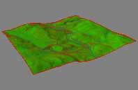
6 3D City Visualization Add a Topographic basemap Streets Shaded Relief Vegetation Labels Buildings Map Template Resource Center Topographic basemap


7 3D City Visualization Add Imagery Sources of imagery - Pictometry Imagery from ArcGIS.com For managing large amount of data, ArcGIS Server Image Extension


8 3D City Visualization Add Elevation Elevation Globes from ArcGIS.com Managing elevation information - Terrain Data Set


9 3D City Visualization Add Buildings Extruded Buildings Textured Buildings Sources of textured buildings - Pictometry Building your own multipatch buildings


10 Data Collection Elevation Types of Data Imagery Subsurface Models and Multipatches Topographic Additional Features Local Across Scales Regional Global
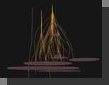
11 DEMO Visualization - 3D Virtual City 3D Data in ArcGlobe elevation, imagery, local and services based data, trees and 3D symbology, textured buildings Sharing via ArcGIS.com as a layer package and as an animation


12 Sharing 3D Information Interactive 3D Mapservices on ArcGIS.com using your ArcGIS Server TerraGO 3D GeoPDF Share Video Animations, screen exports Layer Packages on ArcGIS.com Communicating GIS using 3D


13 Lyr Package from ArcGlobe - Share at ArcGIS.com


14 Manage 3D Information City planning Civil engineering Manage Natural resources Facilities management Defense / Public Safety Create, Build, and Manage GIS in 3D


15 3D Editing The 10 editing environment is now available in 3D - ArcScene - For localized, precision edits - ArcGlobe - For sketching / feature placement globally Supports standard editing capabilities - Feature Templates, Delete, Undo / Redo, Attribute edits, Relationship classes, etc Allows 3D geometry edits - Create vertical lines - Classic snapping is available - Move, rotate, scale, and replace feature geometry
16 DEMO - Managing 3D GIS Data - 3D Editing Editing in 3D - Underground Subway Entrances and Stairways showing template based editing and feature snapping
17 NOTE EXPANDED FROM ORIGINAL TALK THIS NEXT SECTION ON 3D BULDING CREATION IS AN ENHANCED VERSION OF THE PRESENTAION WITH MANY MORE SLIDES (DIRECTORS CUT)
18 Overview of Steps for Creating a 3D Building 1. Convert ArcGIS Footprint to Sketchup 2. Research Building Measurements 3. Model building shape in Sketchup 4. Create building textures in GIMP 5. Replace ArcGIS Multipatch Geometry with New Model
19 Convert ArcGIS Footprint to Sketchup 1. Extrude 2D Footprint to 3D Layer in ArcGlobe 2. Convert to Multipatch 3. Convert to Collada 4. Import Collada into Sketchup

20 Digitize 2D Footprint in ArcMap using Imagery Its highly recommended to use a coordinate system that has the same units for X, Y, and Z (ie a UTM zone with Z s in meters) Imagery can be used as reference Note In ArcGIS 10, now could also edit in 3D in ArcScene or ArcGlobe For multiple buildings, keep them as separate features in the same featureclass

21 Add 2D Polygon to ArcGlobe


22 Set Symbology to Extrude by a Height in Meters Ideally, if you already know the building or number of floors you could use that as a reasonable approximation


23 Use Layer to 3D Feature Class Tool The output Feature Class should be in a FGB

24 The Result is a New Multipatch This creates a multipatch type of Feature Class, which is a true volumetric shape

25 Tip for seeing the new Multipatch if it Isn t Visible Go the layer type view in the ArcGlobe Table of Contents and change the type for the new multipatch to draped. Right click on the multipatch and refresh it it should now appear. It will look just like the extruded polygon. Note we will edit this multipatch later.


26 Use Multipatch to Collada Tool The output is a folder containing a kml pointer to a dae collada model Check off Prepend Source Name to make the collada name easy to understand
27 About Collada Files (.dae file) Collada is the 3D format compatible with Google Earth and Google Sketchup They can be opened, edited, and exported with Google Sketchup Textures can be added to them They can replace an existing multipatch within a 3D Edit session in ArcGlobe Many.KMZ files are of 3D buildings that are zipped containers with a.dae file inside


28 Open Sketchup 8 and Import the Collada Model Use file Import - dae In Sketchup use File / Import to bring it in.

29 If you Get an Error, Click Past it
 The faces are colored black by")
30 The Result is a new Sketchup Model It is actually a single component (a sketchup concept) The faces are colored black by default


31 Explode The Model and Color the Faces Right click the component to select it, and choose explode so you can edit the faces Use the paint bucket tool to color each face white so you can see them
32 Research Building Measurements 1. Gather Oblique Imagery, CAD drawings 2. Determine heights of floors, number of floors, roof and first floor heights 3. Decide on which 3D building block primitive shapes you will need for the most basic structure

33 Example CDC Building in Atlanta in BING This is a CDC building in Atlanta that we will model BING oblique imagery is used as a guide
34 Understand our Building Better We need to determine the real world size of the building - We knows the XY footprint already - Need to know Z height of each section We need to understand the 3D shapes that come together to comprise the shape - Arches - Towers - Tunnels - Roof Variations - Ledges - Overhangs Each surface can be a different texture - Concrete - Window - Metal
35 Understand Building Heights in Relation to Floors Office Residential/hotel Mixed-Use floor-to-floor height (f) Entrance lobby level floor-to-floor height 3.9m 3.1m 3.5m 2.0f = 7.8m 1.5f = 4.65m 1.75f = 6.125m Number of mechanical floors above ground (excluding those on the roof) s/20 = One mechanical floor every 20 stories s/30 = One mechanical floor every 30 stories s/25 = One mechanical floor every 25 stories Height of mechanical floors 2.0f = 7.8m 1.5f = 4.65m 1.75f = 6.125m
36 Understand Floor Makeup Appears to be 10 normal floors, suspended over a two story ground level floor, with a few rooftop structures above

37 Another Building Example - Look at Oblique Imagery to See Floor Makeup 5 Floors Appears to be 5 normal floors, suspended over an unusual ground level floor, with substantial rooftop structures above

38 Rotate Oblique Imagery to Learn More Entry Floor looks to be of same height compared to other five floors Roof Structure appears to be about two floors high at highest point of curve
39 Research the Building Type and Determine Heights For Example Floor Height 5 floors - 5 * 3.9 Entry Level 1 floor 1 * 3.9 m Roof Height 2 floors 2 * 3.9 m In sketchup create construction lines (Sketchup concept) to show height breakpoints


40 Look at all Sides to Understand Geometry and Slices to Create in Sketchup
41 Model building shape in Sketchup 1. Learn how to use Sketchup, especially the strategy of using components, using construction lines, extrusion, and inferring. There are many instruction videos on the sketchup website. 2. Extrude and create building using separate components using correct heights and distances for realism 3. Assemble components into the final building

")
42 Finished Model (non textures)
43 Create building textures 1. View Imagery to determine non-solid surface patterns 2. Color all solid surfaces with the Paint tool 3. Create custom textures for special surfaces in GIMP 4. Position and scale custom textures to faces in sketchup


44 Assign Appropriate Solid Colors to All Faces


45 Identify as few Custom Textures as Needed This building example only needs one texture for a green /gray modern window. It is drawn in GIMP by hand and inferred from a section of the building photo. This is a preferable method to photo draping for stylized buildings. Reality is simplified and cartographically presented. The file size is also smaller. BING Imagery
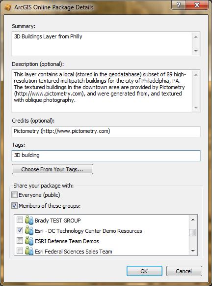
46 The Final Model with a Window Texture This building took roughly 3.5 hours to model the shape, and a half hour to design the single custom texture. The modeler was an intermediate sketchup user who had made other buildings in the past. This building is distinct enough to model in detail, and a city of one million people might have such buildings to create.

47 Final Model Rear View BING Image of rear
48 Replace Multipatch Geometry with New Model 1. Save as Collada File (Sketchup 6 is also supported) 2. Replace multipatch with Collada in an ArcGlobe edit session


49 Export the Sketchup Model as a new Collada File Use Export / 3D Model to.dae collada format
50 Start Editing in ArcGlobe Start an Edit Session in ArcGlobe and choose the Multipatch we created earlier to edit Click on the Edit Placement Tool..

51 Select the Model with the Edit Placement Tool

52 Choose Replace Model from the Editing Toolbar
 feature geometry, so if the user changes the overall footprint of the model in SketchUp (eg: they add a")
53 Replace the Model 1. Choose the Collada Model.dae file The centroid of the imported model is used to position the new (imported / updated) feature geometry, so if the user changes the overall footprint of the model in SketchUp (eg: they add a new wing, or a garage) then they will see the model jump or move when the import the new model. Users will then need to interactively move the feature to its correct position. The Replace model action is undoable within the edit session, so users can always undo the import (or not save their edits).

 and you")

54 Replace the Model cont. 2. Stop Editing, Save 3. Refresh the model (right click on layer) and you will see the textures. All done! The textures will disappear

55 Option Share on ArcGIS.com as a Layer Package Right Click on the Layer in the Table of Contents to Share as a Layer Package on ArcGIS.com Others can then find it on ArcGIS.com, download it, and use it in ArcGlobe or ArcGIS Explorer

56 Here is Our Layer Package Loaded in another users ArcGIS Explorer after Finding it on ArcGIS.com
57 DEMO - Managing 3D GIS Data - 3D Building Creating a 3D textured building from scratch using a footprint and oblique imagery from BING
58 LIDAR and Terrains

59 Terrain Dataset A Terrain is a multi-resolution surface created from measurements stored in feature classes Typical applications: - Topographic mapping - Bathymetric mapping Typical data sources: - Photogrammetric data - Lidar - Sonar
60 Motivating Forces Scalability - Large collections of mass point data (lidar) have been a problem Data integration - Many organizations are charged with keeping accurate and up to date topographic/bathymetric surfaces Data management - Terrains offer database oriented solution for managing source data from which these surfaces are derived
61 Limitations to Overcome TINs have an effective limit of 20 million points - It s recommended not to go over 3-5 million Updating TINs relative to edits of source data is difficult - They are disconnected Rasters are derivative - Difficult to update without rebuilding from source data

62 LAS Data in ArcScene MT St Helens

63 What are Terrain Datasets? Terrain datasets live inside feature datasets within the geodatabase Identify which feature classes participate and how they contribute Rules specify how features are used to define a surface


64 Multi-Resolution Surface Model Points and Breaklines Terrain Pyramids Thinned Point Set Full Resolution Multi-resolution terrain dataset (TIN structure)
65 Implementation Levels of Detail TIN surface generated on-the-fly for given area of interest and level of detail Supports point, multipoint, polyline, and polygon based features Seamless Fast Scalable

66 Implementation - Tiling Data is structured, internally, into tiles Spatial coherence and tiling (point clustering) Each tile contains a manageable amount of data Facilitates processing large amounts of data Z tolerance and vertical indexing Measurement update and dirty-areas Localized processing

67 Interactive Surface Analysis Interactive surface tools 3D Analyst toolbar in ArcMap


68 Geoprocessing with Terrains Geoprocessing with Terrain Datasets - Terrain Management toolset - Creation - Modification - Data conversion toolset - Data loading - Surface conversions - Terrain and TIN Surface toolset - Analysis conducted directly on terrains

69 Analysis Capabilities for Terrain Datasets QA/QC lidar data DEM / DSM creation Slope Aspect Contours Surface differencing Intensity image generation Estimating Forest Canopy Data area delineation Thinning / reducing noise Spot interpolation Profiling
70 DEMO - Hydro Enforcement Demo with a Terrain
71 DEMOS - Visualization of 2D data in 3D Extruded polygons by attribute Court Bankruptcy Cases 3D Surface for 2D Density Traffic in Virginia
72 Final Demo - Using our Shared Content with AGX My content from today all added back into ArcGIS Explorer (AGX) from ArcGIS.com User content (Everest) from ArcGIS.com

73 Further Resources Please visit the Esri Resource Center for more information at and click on 3D GIS


74
3D Data Modelling at Esri. Paul Hardy Business Development Consultant Esri Europe
 3D Data Modelling at Esri Paul Hardy phardy@esri.com Business Development Consultant Esri Europe Users of 3D GIS Local government Facilities management Civil engineering 3D GIS Defense / Public Safety
Esri UC2013. Technical Workshop. Type Presentation Name Here
 Type Presentation Name Here 2013 Esri International User Conference July 8 12, 2013 San Diego, California Technical Workshop 3D Analyst An Introduction Deepinder Deol Michael Contreras Why use 3D GIS?
Creating, managing and utilizing a 3D Virtual City in ArcGIS Tamrat Belayneh Eric Wittner
 Creating, managing and utilizing a 3D Virtual City in ArcGIS 10.1 Tamrat Belayneh (tbelayneh@esri.com) Eric Wittner (ewittner@esri.com ) Contents 3D Mapping & Ingredients of a 3D Virtual City Creating
From 2D to 3D at Esri
 From 2D to 3D at Esri OGC/EuroSDR workshop on CityGML in National Mapping Paul Hardy phardy@esri.com Business Development Consultant National Mapping & Cadastre Esri 3D GIS Visualize Manage Share Analyze
GEOGRAPHIC INFORMATION SYSTEMS Lecture 25: 3D Analyst
 GEOGRAPHIC INFORMATION SYSTEMS Lecture 25: 3D Analyst 3D Analyst - 3D Analyst is an ArcGIS extension designed to work with TIN data (triangulated irregular network) - many of the tools in 3D Analyst also
Visualization with ArcGlobe. Brady Hoak
 Visualization with ArcGlobe Brady Hoak Contents What is ArcGlobe? 3D Mapping and ArcGlobe Displaying data in ArcGlobe ArcGlobe tools Tips for constructing ArcGlobe documents New at ArcGIS 9.3 ArcGIS integration
Managing Lidar and Photogrammetric Point Clouds. Lindsay Weitz Cody Benkelman
 and Photogrammetric Point Clouds Lindsay Weitz Cody Benkelman Presentation Context What is lidar, and how does it work? Not this presentation! What can you do with lidar in ArcGIS? What does Esri recommend
Lidar and GIS: Applications and Examples. Dan Hedges Clayton Crawford
 Lidar and GIS: Applications and Examples Dan Hedges Clayton Crawford Outline Data structures, tools, and workflows Assessing lidar point coverage and sample density Creating raster DEMs and DSMs Data area
3D Analysis Tools and Visualization with ArcGIS. Jie Chang Jinwu Ma
 3D Analysis Tools and Visualization with ArcGIS Jie Chang Jinwu Ma Why 3D GIS? Because our world is 3D Improve understanding 3D is easy for everyone to understand Solve 3D problems Some spatial problems
An Introduction to Using Lidar with ArcGIS and 3D Analyst
 FedGIS Conference February 24 25, 2016 Washington, DC An Introduction to Using Lidar with ArcGIS and 3D Analyst Jim Michel Outline Lidar Intro Lidar Management Las files Laz, zlas, conversion tools Las
COPYRIGHTED MATERIAL. Introduction to 3D Data: Modeling with ArcGIS 3D Analyst and Google Earth CHAPTER 1
 CHAPTER 1 Introduction to 3D Data: Modeling with ArcGIS 3D Analyst and Google Earth Introduction to 3D Data is a self - study tutorial workbook that teaches you how to create data and maps with ESRI s
Contents What is 3D Mapping Creating g the 3D Dataset Ingredients of a 3D Virtual City Publishing 3D Globes The Road ahead Questions and Answers
 Creating a 3D Virtual City Using ArcGIS Tamrat Belayneh Hardeep Bajwa Contents What is 3D Mapping Creating g the 3D Dataset Ingredients of a 3D Virtual City Publishing 3D Globes The Road ahead Questions
Surface Analysis with 3D Analyst
 2013 Esri International User Conference July 8 12, 2013 San Diego, California Technical Workshop Surface Analysis with 3D Analyst Khalid H. Duri Esri UC2013. Technical Workshop. Why use 3D GIS? Because
From 2D to 3D at Esri
 From 2D to 3D at Esri Paul Hardy, Esri Inc phardy@esri.com, Cambridge, UK SHORT PAPER This short paper provides an overview of the 3D capabilities of a modern GIS, illustrated by the Esri ArcGIS system,
Image Services for Elevation Data
 Image Services for Elevation Data Peter Becker Need for Elevation Using Image Services for Elevation Data sources Creating Elevation Service Requirement: GIS and Imagery, Integrated and Accessible Field
MODULE 1 BASIC LIDAR TECHNIQUES
 MODULE SCENARIO One of the first tasks a geographic information systems (GIS) department using lidar data should perform is to check the quality of the data delivered by the data provider. The department
Creating raster DEMs and DSMs from large lidar point collections. Summary. Coming up with a plan. Using the Point To Raster geoprocessing tool
 Page 1 of 5 Creating raster DEMs and DSMs from large lidar point collections ArcGIS 10 Summary Raster, or gridded, elevation models are one of the most common GIS data types. They can be used in many ways
Esri International User Conference. July San Diego Convention Center. Lidar Solutions. Clayton Crawford
 Esri International User Conference July 23 27 San Diego Convention Center Lidar Solutions Clayton Crawford Outline Data structures, tools, and workflows Assessing lidar point coverage and sample density
Introduction to 3D Analysis. Jinwu Ma Jie Chang Khalid Duri
 Introduction to 3D Analysis Jinwu Ma Jie Chang Khalid Duri Area & Volume 3D Analyst Features Detect Change Determine Cut/Fill Calculate Surface Area & Volume Data Management Data Creation Data Conversion
Integrating CAD Data with ArcGIS
 Integrating CAD Data with ArcGIS Agenda An Overview of CAD Drawings CAD Data Structure in ArcGIS Visualization Georeferencing Data Conversion ArcGIS for AutoCAD Q & A CAD Drawings - Overview Widely used
Introduction to GIS 2011
 Introduction to GIS 2011 Digital Elevation Models CREATING A TIN SURFACE FROM CONTOUR LINES 1. Start ArcCatalog from either Desktop or Start Menu. 2. In ArcCatalog, create a new folder dem under your c:\introgis_2011
ArcGIS Pro Editing. Jennifer Cadkin & Phil Sanchez
 ArcGIS Pro Editing Jennifer Cadkin & Phil Sanchez ArcGIS Pro Editing Overview Provides tools that allow you to maintain, update, and create new data - Modifying geometry, drawing new features - Entering
Building 3D models with the horizons method
 ARC HYDRO GROUNDWATER TUTORIALS SUBSURFACE ANALYST Building 3D models with the horizons method Arc Hydro Groundwater (AHGW) is a geodatabase design for representing groundwater datasets within ArcGIS.
ArcGIS Pro Editing: An Introduction. Jennifer Cadkin & Phil Sanchez
 ArcGIS Pro Editing: An Introduction Jennifer Cadkin & Phil Sanchez See Us Here WORKSHOP ArcGIS Pro Editing: An Introduction LOCATION SDCC - Ballroom 20 D TIME FRAME Thursday 10:00 11:00 ArcGIS Pro: 3D
ArcGIS Desktop The Road Ahead. Amadea Azerki
 ArcGIS Desktop The Road Ahead Amadea Azerki Agenda An Overview of ArcGIS 10 Desktop Enhancements User Interface Mapping Editing Analysis Sharing Q & A ArcGIS 10 Overview Focuses on Usability and Productivity
3DCity: Create 3D city features
 3DCity: Create 3D city features Workflow: 3D City Creation Version: 1.0 Date: September 12, 2012 Map templates and workflows are ArcGIS resources that can be used to help create 2D / 3D maps and web map
Creating Contours using ArcMap
 Creating Contours with ArcMap and ArcScene Digital elevation models (DEMs) are geospatial datasets that contain elevation values sampled according to a regularly spaced rectangular grid. They can be used
Sharing 3D Content on the Web
 Sharing 3D Content on the Web Nathan Shephard, Gert van Maren Why 3D GIS? Because our world is 3D Improve understanding 3D is easy for everyone to understand Better communication 3D makes it easier to
Exporting ArcScene to 3D Web Scenes. Documents. An Esri White Paper November 2013
 Exporting ArcScene to 3D Web Scenes Documents An Esri White Paper November 2013 Copyright 2013 Esri All rights reserved. Printed in the United States of America. The information contained in this document
Creating and Maintaining Your 3D Basemap. Brian Sims Dan Hedges Gert van Maren
 Creating and Maintaining Your 3D Basemap Brian Sims Dan Hedges Gert van Maren Complementary Resource Email (no marketing) A copy of the presentation Links to today s web demos Links to training materials
Surface Creation & Analysis with 3D Analyst
 Esri International User Conference July 23 27 San Diego Convention Center Surface Creation & Analysis with 3D Analyst Khalid Duri Surface Basics Defining the surface Representation of any continuous measurement
2011 Bentley Systems, Incorporated. Bentley Descartes V8i Advancing Information Modeling For Intelligent Infrastructure
 Bentley Descartes V8i Advancing Information Modeling For Intelligent Infrastructure Agenda Why would you need Bentley Descartes? What is Bentley Descartes? Advanced Point Cloud Workflows Advanced Terrain
Feature Extraction from Imagery & Lidar. Kurt Schwoppe, Esri Mark Romero, Esri Gregory Bacon, Fairfax County
 Feature Extraction from & Lidar Kurt Schwoppe, Esri Mark Romero, Esri Gregory Bacon, Fairfax County Today s Speakers Image Processing Experts and Good Colleagues Kurt Schwoppe Industry Lead Esri Mark Romero
3D in the Browser with WebGL. Chris Andrews 3D Product Manager Javier Gutierrez 3D Product Engineer
 3D in the Browser with WebGL Chris Andrews 3D Product Manager Javier Gutierrez 3D Product Engineer Just sayin This is not a programming class Goal is to help you learn about a technology area that impacts
Using VBA and ArcMap to Create and Export 3D Buildings
 Using VBA and ArcMap to Create and Export 3D Buildings Abstract Brian Bradshaw Layers in ArcScene containing polygon features can be extruded to create 3D blocks for display in the current scene. While
Paul Hardy. We Live in a Rapidly Changing World. Mobile Mapping: Collect, Manage, Produce, Share. MMT Krakow, Many Forces Are Converging
 Mobile Mapping: Collect, Manage, Produce, Share MMT Krakow, 2011 Paul Hardy We Live in a Rapidly Changing World Increasingly Driven by Population Growth & Human Action Impacting Environment Society Economy
The 3D Analyst extension extends ArcGIS to support surface modeling and 3- dimensional visualization. 3D Shape Files
 NRM 435 Spring 2016 ArcGIS 3D Analyst Page#1 of 9 0B3D Analyst Extension The 3D Analyst extension extends ArcGIS to support surface modeling and 3- dimensional visualization. 3D Shape Files Analogous to
Lidar Working with LAS Datasets
 2013 Esri International User Conference July 8 12, 2013 San Diego, California Technical Workshop Lidar Working with LAS Datasets Raghav Vemula (3D Team) Esri UC2013. Technical Workshop. Agenda Las Dataset
Alaska Department of Transportation Roads to Resources Project LiDAR & Imagery Quality Assurance Report Juneau Access South Corridor
 Alaska Department of Transportation Roads to Resources Project LiDAR & Imagery Quality Assurance Report Juneau Access South Corridor Written by Rick Guritz Alaska Satellite Facility Nov. 24, 2015 Contents
Steps for Modeling a Proposed New Reservoir in GIS
 Steps for Modeling a Proposed New Reservoir in GIS Requirements: ArcGIS ArcMap, ArcScene, Spatial Analyst, and 3D Analyst There s a new reservoir proposed for Right Hand Fork in Logan Canyon. I wanted
Best Practices for Designing Effective Map Services
 2013 Esri International User Conference July 8 12, 2013 San Diego, California Technical Workshop Best Practices for Designing Effective Map Services Ty Fitzpatrick Tanu Hoque What s in this session Map
GY461 GIS 1: Environmental Campus Topography Project with ArcGIS 9.x
 I. Introduction GY461 GIS 1: Environmental In this project you will use data from a topographic survey of the USA campus to generate 2 separate maps: 1. A color-coded 2-dimensional topographic contour
Lecture 21 - Chapter 8 (Raster Analysis, part2)
") GEOL 452/552 - GIS for Geoscientists I Lecture 21 - Chapter 8 (Raster Analysis, part2) Today: Digital Elevation Models (DEMs), Topographic functions (surface analysis): slope, aspect hillshade, viewshed,
GEOL 452/552 - GIS for Geoscientists I Lecture 21 - Chapter 8 (Raster Analysis, part2) Today: Digital Elevation Models (DEMs), Topographic functions (surface analysis): slope, aspect hillshade, viewshed,
LAB #7 Creating TIN and 3D scenes (ArcScene) GISC, UNIVERSITY OF CALIFORNIA BERKELEY
 GISC, UNIVERSITY OF CALIFORNIA BERKELEY") LAB #7 Creating TIN and 3D scenes (ArcScene) GISC, UNIVERSITY OF CALIFORNIA BERKELEY The purpose of this laboratory is to introduce and explore surface data analysis using a vector data model: TIN. We
LAB #7 Creating TIN and 3D scenes (ArcScene) GISC, UNIVERSITY OF CALIFORNIA BERKELEY The purpose of this laboratory is to introduce and explore surface data analysis using a vector data model: TIN. We
Digital Elevation Models (DEM)
") Digital Elevation Models (DEM) Digital representation of the terrain surface also referred to as Digital Terrain Models (DTM) Digital Elevation Models (DEM) How has relief depiction changed with digital
Digital Elevation Models (DEM) Digital representation of the terrain surface also referred to as Digital Terrain Models (DTM) Digital Elevation Models (DEM) How has relief depiction changed with digital
Implementing and Optimizing ArcGIS Server Map Caches
 Implementing and Optimizing ArcGIS Server Map Caches Sterling Quinn Jeremy Bartley David Wilcox ESRI Developer Summit 2008 1 Schedule 75 minute session 60 65 minute lecture 10 15 minutes Q & A following
Cartographic Techniques and Representations
 Cartographic Techniques and Representations NEARC 2007 ESRI Technical Session ESRI, Boston Overview of Presentation Labeling and Annotation Masking Layout Tips Cartographic Representations Labeling versus
Getting Started With LP360
 Getting Started With LP360 12/22/2015 1 Contents What is LP360?... 3 System Requirements... 3 Installing LP360... 4 How to Enable the LP360 Extension... 4 How to Display the LP360 Toolbar... 4 How to Import
Image Management and Dissemination. Peter Becker
 Image Management and Dissemination Peter Becker OUTLINE Requirements Intro to Mosaic Datasets Workflows & Demo Dynamic Mosaicking, On-the-fly processing Properties Differentiator Raster Catalog, ISDef,
Masking Lidar Cliff-Edge Artifacts
 Masking Lidar Cliff-Edge Artifacts Methods 6/12/2014 Authors: Abigail Schaaf is a Remote Sensing Specialist at RedCastle Resources, Inc., working on site at the Remote Sensing Applications Center in Salt
A Second Look at DEM s
 A Second Look at DEM s Overview Detailed topographic data is available for the U.S. from several sources and in several formats. Perhaps the most readily available and easy to use is the National Elevation
Data Interoperability Advanced Use
 Data Interoperability Advanced Use Bruce Harold Dale Lutz bharold@esri.com Safe Software This is your world ask us today about best practices Automate Moving Data No Domain Limitations ArcGIS Data Interoperability
Managing and Serving Elevation and Lidar Data. Cody Benkelman UC 2018
 Managing and Serving Elevation and Lidar Data Cody Benkelman UC 2018 Outline Usage Modes Data Management - Architecture - Workflow Automation for Repeatability & Scalability A few options Usage Modes of
An Introduction to Lidar & Forestry May 2013
 An Introduction to Lidar & Forestry May 2013 Introduction to Lidar & Forestry Lidar technology Derivatives from point clouds Applied to forestry Publish & Share Futures Lidar Light Detection And Ranging
Your Prioritized List. Priority 1 Faulted gridding and contouring. Priority 2 Geoprocessing. Priority 3 Raster format
 Your Prioritized List Priority 1 Faulted gridding and contouring Priority 2 Geoprocessing Priority 3 Raster format Priority 4 Raster Catalogs and SDE Priority 5 Expanded 3D Functionality Priority 1 Faulted
LASERDATA LIS build your own bundle! LIS Pro 3D LIS 3.0 NEW! BETA AVAILABLE! LIS Road Modeller. LIS Orientation. LIS Geology.
 LIS 3.0...build your own bundle! NEW! LIS Geology LIS Terrain Analysis LIS Forestry LIS Orientation BETA AVAILABLE! LIS Road Modeller LIS Editor LIS City Modeller colors visualization I / O tools arithmetic
2011 Bentley Systems, Incorporated. Bentley Descartes V8i (SELECTseries 3) Advancing Information Modeling For Intelligent Infrastructure
 Advancing Information Modeling For Intelligent Infrastructure") Bentley Descartes V8i (SELECTseries 3) Advancing Information Modeling For Intelligent Infrastructure What is Bentley Descartes? Image Processing Raster Geo-Referencing Advanced raster transformation (warping,
Bentley Descartes V8i (SELECTseries 3) Advancing Information Modeling For Intelligent Infrastructure What is Bentley Descartes? Image Processing Raster Geo-Referencing Advanced raster transformation (warping,
Setting up a 3D Environment for the City of Portland
 Setting up a 3D Environment for the City of Portland www.learn.arcgis.com 380 New York Street Redlands, California 92373 8100 USA Copyright 2018 Esri All rights reserved. Printed in the United States of
1. Folder Structure, Terrain Feature Dataset, and Geodatabase Creation
 1. Folder Structure, Terrain Feature Dataset, and Geodatabase Creation You will be working with a lot of different files and it is important to keep them organized so that is easy to place and locate things.
What s s Coming in ArcGIS 10 Desktop
 What s s Coming in ArcGIS 10 Desktop Damian Spangrud ArcGIS Product Manager, ESRI dspangrud@esri.com (or at least turn to silent) ArcGIS 10 A Simple & Pervasive System for Using Maps & Geographic Information
PUG List. Raster Analysis 3D Analysis Geoprocessing. Steve Kopp
 PUG List Raster Analysis 3D Analysis Geoprocessing Steve Kopp Contour Polygons Spatial Analyst - color-filled contours. Similar to thematic classification, where blue = -1000 to zero, and red = 0 to +1000,
N.J.P.L.S. An Introduction to LiDAR Concepts and Applications
 N.J.P.L.S. An Introduction to LiDAR Concepts and Applications Presentation Outline LIDAR Data Capture Advantages of Lidar Technology Basics Intensity and Multiple Returns Lidar Accuracy Airborne Laser
An ESRI Technical Paper May 2007 Techniques for Consuming 3D Textured Objects in ArcGlobe and ArcScene
 An ESRI Technical Paper May 2007 Techniques for Consuming 3D Textured Objects in ArcGlobe and ArcScene ESRI 380 New York St., Redlands, CA 92373-8100 USA TEL 909-793-2853 FAX 909-793-5953 E-MAIL info@esri.com
GIS IN ECOLOGY: VISUALIZING IN 3D
 GIS IN ECOLOGY: VISUALIZING IN 3D Contents Introduction... 2 3D Analyst and ArcScene... 2 3D Data... 2 Course Data Sources... 3 Instructions for Copying the Course Dataset... 4 Tasks... 4 Visualizing and
Visualizing 2D Data in a 3D World
 Visualizing 2D Data in a 3D World Karl Kliparchuk, M.Sc., GISP, and Brendan Walashek, B.Sc. McElhanney Consulting Services Ltd. Email: kkliparchuk@mcelhanney.com and bwalashek@mcelhanney.com Agenda A Quick
Exelis Visual Information Solutions Capability Overview Presented to NetHope October 8, Brian Farr Academic & NGO Program Manager
 Exelis Visual Information Solutions Capability Overview Presented to NetHope October 8, 2013 Brian Farr Academic & NGO Program Manager Agenda Overview of ENVI Platform ENVI+IDL ENVI EX ENVI LiDAR Integration
LORI COLLINS, RESEARCH ASSOCIATE PROFESSOR CONTRIBUTIONS BY: RICHARD MCKENZIE AND GARRETT SPEED, DHHC USF L IBRARIES
 LORI COLLINS, RESEARCH ASSOCIATE PROFESSOR CONTRIBUTIONS BY: RICHARD MCKENZIE AND GARRETT SPEED, DHHC USF L IBRARIES AERIAL AND TERRESTRIAL SURVEY WORKFLOWS Workflow from project planning applications
Designing and Using Basemaps. Jennifer Hughey
 Designing and Using Basemaps Jennifer Hughey Agenda The ArcGIS System Basemaps are a key component of your system Cartographic design considerations Using basemap layers in ArcMap Best practices for designing
Import, view, edit, convert, and digitize triangulated irregular networks
 v. 10.1 WMS 10.1 Tutorial Import, view, edit, convert, and digitize triangulated irregular networks Objectives Import survey data in an XYZ format. Digitize elevation points using contour imagery. Edit
SketchUp + Google Earth LEARNING GUIDE by Jordan Martin. Source (images): Architecture
: Architecture") SketchUp + Google Earth LEARNING GUIDE by Jordan Martin Source (images): www.sketchup.com Part 1: Getting Started with SketchUp GETTING STARTED: Throughout this manual users will learn different tools
SketchUp + Google Earth LEARNING GUIDE by Jordan Martin Source (images): www.sketchup.com Part 1: Getting Started with SketchUp GETTING STARTED: Throughout this manual users will learn different tools
Designing and Using Cached Map Services
 Esri International User Conference San Diego, California Technical Workshops July 2012 Designing and Using Cached Map Services Sterling Quinn Eric Rodenberg What we will cover Session Topics - Map cache
Introduction to ArcGIS Server 10.1
 Introduction to ArcGIS Server 10.1 E-Learning for the GIS Professional Any Time, Any Place! geospatialtraining.com Module Outline What is ArcGIS Server? GIS Resources and Services ArcGIS Server Components
IndianaMap Release 3. Rick Hill, Paul Rohwer,, Chris Dintaman, Becky Meyer, and Denver Harper
 IndianaMap Release 3 Rick Hill, Paul Rohwer,, Chris Dintaman, Becky Meyer, and Denver Harper IndianaMap Agenda Session 1 & 2 Overview Tentative rollout schedule Old versus New Design and construction of
Converting Lidar Data to Shapefile and Raster File Format for Analysis and Viewing
 Converting Lidar Data to Shapefile and Raster File Format for Analysis and Viewing 1. Create a File Based Geodatabase Open ArcCatolog and right click under contents and click New and File Geodatabase where
Delineating Watersheds from a Digital Elevation Model (DEM)
") Delineating Watersheds from a Digital Elevation Model (DEM) (Using example from the ESRI virtual campus found at http://training.esri.com/courses/natres/index.cfm?c=153) Download locations for additional
Delineating Watersheds from a Digital Elevation Model (DEM) (Using example from the ESRI virtual campus found at http://training.esri.com/courses/natres/index.cfm?c=153) Download locations for additional
Chris Rotondo, GIS Specialist. Prince George s County Planning Department The Maryland-National Capital Park and Planning Commission
 Chris Rotondo, GIS Specialist Prince George s County Planning Department The Maryland-National Capital Park and Planning Commission MSGIC, July 2015 A 150-page report on implementing 3D technology, prepared
GIS IN ECOLOGY: VISUALIZING IN 3D
 GIS IN ECOLOGY: VISUALIZING IN 3D Contents Introduction... 2 3D Analyst and ArcScene... 2 3D Data... 3 Course Data Sources... 4 Copying the Course Dataset... 5 Tasks... 5 Creating/Converting 3D Data...
What s New in Desktop 10.1
 What s New in Desktop 10.1 Damian Spangrud Esri Redlands Trip Down Memory Lane ArcGIS A Complete System for Geographic Information Cloud Web Online Mobile Enterprise Desktop Sharing Information sharing
3D in the ArcGIS Platform. Chris Andrews
 3D in the ArcGIS Platform Chris Andrews Geospatial 3D is already all around us 3D is expanding the GIS community s opportunity to provide value 3D City & Infrastructure Models Generated 3D features Photogrammetrc
TCP MDT Digital Terrain Model - V7.5
 TCP MDT Digital Terrain Model - V7.5 Standard Version Introduction The Standard Version is suitable for carrying out all kinds of topographical survey projects, terrain profiles, volume calculations etc.
The Reference Library Generating Low Confidence Polygons
 GeoCue Support Team In the new ASPRS Positional Accuracy Standards for Digital Geospatial Data, low confidence areas within LIDAR data are defined to be where the bare earth model might not meet the overall
Drone2Map for ArcGIS: Bring Drone Imagery into ArcGIS
 Drone2Map for ArcGIS: Bring Drone Imagery into ArcGIS Mike Sweeney 1 Drone2Map for ArcGIS Turn Drones into Enterprise Productivity Tools ArcGIS Drone2Map for ArcGIS Create 2D and 3D products from raw drone
THE HONG KONG POLYTECHNIC UNIVERSITY DEPARTMENT OF LAND SURVEYING & GEO-INFORMATICS LSGI521 PRINCIPLES OF GIS
 THE HONG KONG POLYTECHNIC UNIVERSITY DEPARTMENT OF LAND SURVEYING & GEO-INFORMATICS LSGI521 PRINCIPLES OF GIS Student name: Student ID: Table of Content Working with files, folders, various software and
BRIEF EXAMPLES OF PRACTICAL USES OF LIDAR
 BRIEF EXAMPLES OF PRACTICAL USES OF LIDAR PURDUE ROAD SCHOOL - 3/9/2016 CHRIS MORSE USDA-NRCS, STATE GIS COORDINATOR LIDAR/DEM SOURCE DATES LiDAR and its derivatives (DEMs) have a collection date for data
Tips for a Good Meshing Experience
 Tips for a Good Meshing Experience Meshes are very powerful and flexible for modeling 2D overland flows in a complex urban environment. However, complex geometries can be frustrating for many modelers
Digital Elevation Model & Surface Analysis
 Topics: Digital Elevation Model & Surface Analysis 1. Introduction 2. Create raster DEM 3. Examine Lidar DEM 4. Deriving secondary surface products 5. Mapping contours 6. Viewshed Analysis 7. Extract elevation
Getting Started. Extruding Features. Convert to feature class
 http://gmv.cast.uark.edu A Method Store for Advanced Survey and Modeling Technologies Mon, 01 Apr 2013 03:29:18 +0000 en-us hourly 1 http://wordpress.org/?v=3.5.1 http://gmv.cast.uark.edu/modeling/software-visualization/sketchup/workflow-sketchup/arcscene-tosketchup-to-arcscene/
Mobile Mapping and Navigation. Brad Kohlmeyer NAVTEQ Research
 Mobile Mapping and Navigation Brad Kohlmeyer NAVTEQ Research Mobile Mapping & Navigation Markets Automotive Enterprise Internet & Wireless Mobile Devices 2 Local Knowledge & Presence Used to Create Most
GE1LC7 - Getting to Know Bentley Descartes for Advanced Image Viewing, Editing and Processing
 GE1LC7 - Getting to Know Bentley Descartes for Advanced Image Viewing, Editing and Processing Inga Morozoff Introduction: Raster data is everywhere - whether you do CAD design, mapping or GIS analysis,
TerraScan Tool Guide
 TerraScan Main Toolbox General Toolbar Draw Toolbar Groups Toolbar Vectorize Towers Toolbar Road Toolbar Buildings Toolbar Building Edges Toolbar View Laser Toolbar Model Toolbar Vectorize Wires Toolbar
Municipal Projects in Cambridge Using a LiDAR Dataset. NEURISA Day 2012 Sturbridge, MA
 Municipal Projects in Cambridge Using a LiDAR Dataset NEURISA Day 2012 Sturbridge, MA October 15, 2012 Jeff Amero, GIS Manager, City of Cambridge Presentation Overview Background on the LiDAR dataset Solar
ArcGIS Pro Terminology Guide
 ArcGIS Pro Terminology Guide Essential Terminology or Functionality That s New to ArcGIS Pro ArcGIS Pro Project Map Scene Ribbon Tab on the ribbon View Active view Pane Gallery Task Quick Access Toolbar
ArcGIS Pro Terminology Guide
 ArcGIS Pro Terminology Guide Sharing Terminology and User Interface Cross-Reference Share content Project package (.ppkx) Map package (.mpkx) Layer package (.lpkx) Share or publish a web layer Share Web
ArcCatalog or the ArcCatalog tab in ArcMap ArcCatalog or the ArcCatalog tab in ArcMap ArcCatalog or the ArcCatalog tab in ArcMap
 ArcGIS Procedures NUMBER OPERATION APPLICATION: TOOLBAR 1 Import interchange file to coverage 2 Create a new 3 Create a new feature dataset 4 Import Rasters into a 5 Import tables into a PROCEDURE Coverage
Should Contours Be Generated from Lidar Data, and Are Breaklines Required? Lidar data provides the most
 Should Contours Be Generated from Lidar Data, and Are Breaklines Required? Lidar data provides the most accurate and reliable representation of the topography of the earth. As lidar technology advances
Esri CityEngine and the Oculus Rift: GIS for Next-Generation Virtual Reality
 Esri CityEngine and the Oculus Rift: GIS for Next-Generation Virtual Reality Brooks Patrick Solutions Engineer 3D Markets BPatrick@esri.com Esri UC 2014 Technical Workshop The entertainment industry continues
National Science Foundation Engineering Research Center. Bingcai Zhang BAE Systems San Diego, CA
 Bingcai Zhang BAE Systems San Diego, CA 92127 Bingcai.zhang@BAESystems.com Introduction It is a trivial task for a five-year-old child to recognize and name an object such as a car, house or building.
Workflows for Managing and Serving Elevation (and Lidar) Data. Cody Benkelman
 Data. Cody Benkelman") Workflows for Managing and Serving Elevation (and Lidar) Data Cody Benkelman Outline Usage Modes Data Management - Architecture - Workflow Automation for Repeatability & Scalability A few options re: Cloud,
Workflows for Managing and Serving Elevation (and Lidar) Data Cody Benkelman Outline Usage Modes Data Management - Architecture - Workflow Automation for Repeatability & Scalability A few options re: Cloud,
introduction to 3D data
 introduction to 3D data MODELING WITH ARCGIS 3D ANALYST AND GOOGLE EARTH K. HEATHER KENNEDY Introduction to 3D Data Introduction to 3D Data Modeling with ArcGIS 3D Analyst and Google Earth K. Heather
What should y you expect in this session? Basic to advanced topics Outline What is map caching? Why should I cache? Caching workflow How to create a c
 Designing, Deploying, and Using Cached Map Services David Crosby & Craig Mesimer What should y you expect in this session? Basic to advanced topics Outline What is map caching? Why should I cache? Caching