Georeferencing Topo Sheets and Scanned Maps
|
|
|
- Terence Carroll
- 6 years ago
- Views:
Transcription


1 Georeferencing Topo Sheets and Scanned Maps QGIS Tutorials and Tips Author Ujaval Gandhi This work is licensed under a Creative Commons Attribution 4.0 International License.
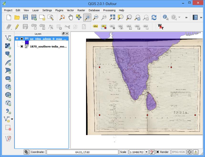
2 Georeferencing Topo Sheets and Scanned Maps Most GIS projects require georeferencing some raster data. Georeferencing is the process of assigning real-world coordinates to each pixel of the raster. Many times these coordinates are obtained by doing field surveys - collecting coordinates with a GPS device for few easily identifiable features in the image or map. In some cases, where you are looking to digitize scanned maps, you can obtain the coordinates from the markings on the map image itself. Using these sample coordinates or GCPs ( Ground Control Points ), the image is warped and made to fit within the chosen coordinate system. In this tutorial I will discuss the concepts, strategies and tools within QGIS to achieve a high accuracy georeferencing. Overview of the task We will use a scanned map of southern India from 1870 and geo-reference it using QGIS. Other skills you will learn How to determine datum and coordinate system for old maps. Get the data Hipkiss s Scanned Old Maps website has an excellent collection out-of-copyright scanned maps that one can use for research. Download the 1870 map of southern India and save it as a JPG image on your hard drive. For convenience, you may directly download a copy of the dataset from the link below: 1870_southern_india.jpg Procedure 1.Georeferencing in QGIS is done via the Georeferencer GDAL plugin. This is a core plugin - meaning it is already part of your QGIS installation. You just need to enable it. Go to Plugins Manage and Install Plugins and enable the Georeferencer GDAL plugin in the Installed tab. See Using Plugins for more details on how to work with plugins.

3 2. The plugin is installed in the Raster menu. Click on Raster Georeferencer Georeferencer to open the plugin.

4 3. The plugin window is divided into 2 sections. The top section where the raster will be displayed and the bottom section where a table showing your GCPs will appear.

5 4. Now we will open our JPG image. Go to File Open Raster. Browse to the downloaded image of the scanned map and click Open.
6 5. In the next screen, you will asked to choose the raster s coordinate reference system (CRS). This is to specify the projection and datum of your control points. If you have collected the ground control points using a GPS device, you would have the WGS84 CRS. If you are geo-referencing a scanned map like this, you can obtain the CRS information from the map itself. Looking at our map image, the coordinates are in Lat/Long. There is no datum information given, so we have to assume an appropriate one. Since it is India and the map is quite old, we can bet the Everest 1830 datum would give us good results.

7 6. You will see the image will be loaded on the top section.

8 7. You can use the zoom/pan controls in the toolbar to learn more about the map.
9 8. Now we need to assign coordinates to some points on this map. If you look closely, you will see coordinate grid with markings. Using this grid, you can determine the X and Y coordinates of the points where the grids intersect. Click on Add Point in the toolbar.


10 9. In the pop-up window, enter the coordinates. Remember that X=longitude and Y=latitude. Click OK. 10. You will notice the GCP table now has a row with details of your first GCP.
11 11. Similarly, add at least 4 GCPs covering the entire image. The more points you have, the more accurate your image is registered to the target coordinates.

12 12. Once you have enough points, go to Settings -> Transformation settings.

13 13. In the Transformation settings dialog, choose the Transformation type as Thin Plate Spline. Name your output raster as 1870_southern_india_modified.tif. Choose EPSG:4326 as the target SRS so the resulting image is in a widely compatible datum. Make sure the Load in QGIS when done option is checked. CLick OK.

14 14. Back in the Georeferencer window, go to File Start georeferencing. This will start the process of warping the image using the GCPs and creating the target raster.
15 15. Once the process finishes, you will see the georeferenced layer loaded in QGIS.

16 16. The georeferencing is now complete. But as always, it's a good practice to verify your work. How do we check if our georeferencing is accurate? In this case, load the country boundaries shapefile from a trusted source like the Natural Earth dataset and compare them. You will notice they match up pretty nicely. There is some error and it can be further improved by taking more control points, changing transformation parameters and trying a different datum.
17
CHAPTER 2 GEOREFERENCING AND SHAPEFILE CREATION
 CHAPTER 2 GEOREFERENCING AND SHAPEFILE CREATION Georeferencing is the process of assigning real-world coordinates to each pixel of the raster. These coordinates are obtained by doing field surveys - collecting
Working with Attributes
 Working with Attributes QGIS Tutorials and Tips Author Ujaval Gandhi http://www.spatialthoughts.com This work is licensed under a Creative Commons Attribution 4.0 International License. Working with Attributes
Georeferencing in QGIS
 Georeferencing in QGIS Introduction Georeferencing is one of the most useful tools for historians. Historic cartographic data can be digitized (scanned, downloaded) and assigned coordinate data on a modern
Second Summer School on Digital Tools for Humanists. Instructions for the hands-on tutorial on GIS
 Second Summer School on Digital Tools for Humanists Instructions for the hands-on tutorial on GIS Augusto Ciuffoletti Dipartimento di Informatica - Università di Pisa Pisa - June 2018 Abstract This document
A Practical Guide to Using QGIS
 A Practical Guide to Using QGIS 1.1 INTRODUCTION Quantum GIS (QGIS) is a useful mapping software that enables the compilation and displaying of spatial data in the form of a map. Gaining experience in
Exercise 1-1: Using GPS track data to create a field boundary
 Exercise 1-1: Using GPS track data to create a field boundary Learning objectives: Add QGIS plugins Create a point vector file from a text file Convert GPS tracking points to a field boundary Data folder:
Launch QGIS. Launch QGIS from. Open window Quantum GIS (Figure 1.1 below) Start All Programs Quantum GIS. QGISIcon on the desk top
 Start All Programs Quantum GIS. QGISIcon on the desk top") QGIS Launch QGIS Launch QGIS from Start All Programs Quantum GIS OR QGISIcon on the desk top Open window Quantum GIS (Figure 1.1 below) 2 Figure 1.1 3 Opening Raster For this exercise we demonstrate three
QGIS Launch QGIS Launch QGIS from Start All Programs Quantum GIS OR QGISIcon on the desk top Open window Quantum GIS (Figure 1.1 below) 2 Figure 1.1 3 Opening Raster For this exercise we demonstrate three
2) Make sure that the georeferencing extension is on by right-clicking in the task bar area and selecting Georeferencing
 Make sure that the georeferencing extension is on by right-clicking in the task bar area and selecting Georeferencing") HGIS Workshop Module 1 Georeferencing Large Scale Scanned Historical Maps Objective: Learn the Principles of Georeferencing 1) In ArcMap, open the project 01 data\arcdata_10_1\arcdata\toronto\georeference.mxd
HGIS Workshop Module 1 Georeferencing Large Scale Scanned Historical Maps Objective: Learn the Principles of Georeferencing 1) In ArcMap, open the project 01 data\arcdata_10_1\arcdata\toronto\georeference.mxd
Exercises Open Source Software for Preprocessing GIS Data for Hydrological Models
 Exercises Open Source Software for Preprocessing GIS Data for Hydrological Models Dr. Hans van der Kwast Senior Lecturer in Ecohydrological Modelling Water Science and Engineering Department E-mail: j.vanderkwast@unesco-ihe.org
All data is in Universal Transverse Mercator (UTM) Zone 6 projection, and WGS 84 datum.
 Zone 6 projection, and WGS 84 datum.") 111 Mulford Hall, College of Natural Resources, UC Berkeley (510) 643-4539 EXPLORING MOOREA DATA WITH QUANTUM GIS In this exercise, you will be using an open-source FREE GIS software, called Quantum GIS,
111 Mulford Hall, College of Natural Resources, UC Berkeley (510) 643-4539 EXPLORING MOOREA DATA WITH QUANTUM GIS In this exercise, you will be using an open-source FREE GIS software, called Quantum GIS,
+ Make it from the satellite images in sale, (Easier & Faster, but not always available) (It does cost much. An astronomical number!
 (It does cost much. An astronomical number!") BaseMap: + Look for it among the existent digital maps, (Easiest & Fastest because no processing required) (Therefore, the most desirable, but not always available) (It can cost much) + Make it from the
BaseMap: + Look for it among the existent digital maps, (Easiest & Fastest because no processing required) (Therefore, the most desirable, but not always available) (It can cost much) + Make it from the
Download the Latest LTR QGIS version (2.18) from the QGIS website: download.qgis.org/ >> Settings > Options > Locale
 from the QGIS website: download.qgis.org/ >> Settings > Options > Locale") Exercise 1: Introduction to QGIS Aim: To understand the basis of GIS To learn the basics of a GIS software (QGIS) INTRODUCTION Software Access Download the Latest LTR QGIS version (2.18) from the QGIS
Exercise 1: Introduction to QGIS Aim: To understand the basis of GIS To learn the basics of a GIS software (QGIS) INTRODUCTION Software Access Download the Latest LTR QGIS version (2.18) from the QGIS
Importing GPS points and Hyperlinking images.
 Geol 3050 GIS for Geologists Exercise 15 Exercise 15 Making a Virtual Fieldtrip: Importing GPS points and Hyperlinking images. Due: Thursday, March 22. Goal: A) Get familiar with importing GPS points and
QGIS LAB SERIES GST 101: Introduction to Geospatial Technology Lab 5: Creating Geospatial Data
 QGIS LAB SERIES GST 101: Introduction to Geospatial Technology Lab 5: Creating Geospatial Data Objective Digitize Information from a Scanned Hardcopy Source Document Version: 2014-06-03 (Final) Author:
Geological mapping using open
 Geological mapping using open source QGIS MOHSEN ALSHAGHDARI -2017- Abstract Geological mapping is very important to display your field work in a map for geologist and others, many geologists face problems
How to perform a quality check of a new dataset. QGIS Tutorials and Tips
 How to perform a quality check of a new dataset QGIS Tutorials and Tips ZanSea zansea@suza.ac.tz 1 Objective GIS datasets can come from many different sources: From a Website. From a USB key given by a
Server Usage & Third-Party Viewers
 Server Usage & Third-Party Viewers October 2016 HiPER LOOK Version 1.4.16.0 Copyright 2015 PIXIA Corp. All Rights Reserved. Table of Contents HiPER LOOK Server Introduction... 2 Google Earth... 2 Installation...2
Objectives Learn how to work with projections in GMS, and how to combine data from different coordinate systems into the same GMS project.
 v. 10.2 GMS 10.2 Tutorial Working with map projections in GMS Objectives Learn how to work with projections in GMS, and how to combine data from different coordinate systems into the same GMS project.
Getting a Square Map Grid in QGIS
 Getting a Square Map Grid in QGIS Recently there have been some changes to the regulations governing the use of UAVs and model aircraft in New Zealand. This is a response to the rapid rise of ownership
Exercise 03 Creating and Editing Shapefiles Assigned Feb. 2, 2018 Due Feb. 9, 2018
 Exercise 03 Creating and Editing Shapefiles Assigned Feb. 2, 2018 Due Feb. 9, 2018 On the class website I've posted an exercise_03_data.zip file which contains a USGS 7.5' quad map of Laramie (as laramie_quad_usgs_1963.tiff)
Batch Clipping in Modeler Geomatica 2015 Tutorial
 In Geomatica, you can use the integration capabilities between Focus and Modeler to create custom models and combine tasks using batch processing. This tutorial shows you how to create a model to clip
How to Align a Non- Georeferenced Image to an Existing Geographic Layer or Georeferenced Image
 How to Align a Non- Georeferenced Image to an Existing Geographic Layer or Georeferenced Image Written by Barbara M. Parmenter, revised 14 October 2011 You can align, or georeference, scanned maps to existing
v SMS 12.2 Tutorial Import from Web Requirements None Time minutes Prerequisites None Objectives
 v. 12.2 SMS 12.2 Tutorial Import from Web Objectives This lesson is designed to give an overview of with the Importing from Web option offered by SMS. This option connects SMS to a web based program that
Searching and Downloading OpenStreetMap Data
 Searching and Downloading OpenStreetMap Data QGIS Tutorials and Tips Author Ujaval Gandhi http://www.spatialthoughts.com This work is licensed under a Creative Commons Attribution 4.0 International License.
Geographic Information Systems. using QGIS
 Geographic Information Systems using QGIS 1 - INTRODUCTION Generalities A GIS (Geographic Information System) consists of: -Computer hardware -Computer software - Digital Data Generalities GIS softwares
Introduction. Contour Lines Generation
 Introduction Over the years the e-foto project has been developed and the need for integration with other Geographic Information Systems software became more evident. From this need several improvements
Objectives Learn how to work with projections in GMS, and how to combine data from different coordinate systems into the same GMS project.
 v. 10.4 GMS 10.4 Tutorial Working with map projections in GMS Objectives Learn how to work with projections in GMS, and how to combine data from different coordinate systems into the same GMS project.
Introduction to using QGIS for Archaeology and History Workshop by the Empirical Reasoning Center
 Introduction to using QGIS for Archaeology and History Workshop by the Empirical Reasoning Center In this workshop, we will cover the basics of working with spatial data, as well as its main uses for archaeology.
v SMS Tutorials Working with Rasters Prerequisites Requirements Time Objectives
 v. 12.2 SMS 12.2 Tutorial Objectives Learn how to import a Raster, view elevations at individual points, change display options for multiple views of the data, show the 2D profile plots, and interpolate
Objectives Learn how to work with projections in SMS, and how to combine data from different coordinate systems into the same SMS project.
 v. 12.2 SMS 12.2 Tutorial Working with map projections in SMS Objectives Learn how to work with projections in SMS, and how to combine data from different coordinate systems into the same SMS project.
v Working with Rasters SMS 12.1 Tutorial Requirements Raster Module Map Module Mesh Module Time minutes Prerequisites Overview Tutorial
 v. 12.1 SMS 12.1 Tutorial Objectives This tutorial teaches how to import a Raster, view elevations at individual points, change display options for multiple views of the data, show the 2D profile plots,
Bharath Setturu Research scholar, EWRG, Center for Ecological Sciences, IISc, Bangalore & EWRG-CES IIIT-HYDERABAD
 Bharath Setturu Research scholar, EWRG, Center for Ecological Sciences, IISc, Bangalore settur@ces.iisc.ernet.in & IIIT-HYDERABAD Introduction to QGIS oquantum GIS (QGIS) is a GIS tool for managing geographical
Objectives Learn how to work with projections in SMS, and how to combine data from different coordinate systems into the same SMS project.
 v. 12.3 SMS 12.3 Tutorial Working with map projections in SMS Objectives Learn how to work with projections in SMS, and how to combine data from different coordinate systems into the same SMS project.
Exercise 3-1: Soil property mapping
 Exercise 3-1: Soil property mapping Mapping objectives: Create a soil analysis point layer from tabular data in QGIS Create a continuous surface soil property map using Kriging Interpolation in SAGA GIS
Geomatica OrthoEngine Adjust Orthos -TPS Model
 Geomatica OrthoEngine Adjust Orthos -TPS Model Adjust Orthos - TPS Model is a tool designed to fix misalignments between orthos using a thin plate spline method. This method allows for an overall better
Introduction to GeoServer
 Tutorial ID: This tutorial has been developed by BVIEER as part of the IGET web portal intended to provide easy access to geospatial education. This tutorial is released under the Creative Commons license.
How to plot a species distribution on a simple map of New Zealand from an Excel file
 How to plot a species distribution on a simple map of New Zealand from an Excel file This is a very simple step by step guide created by a beginner using QGIS for a beginner using QGIS. It will help you
v SMS 12.2 Tutorial Online Data Dynamic Images Prerequisites None Requirements Internet Connection Time minutes
 v. 12.2 SMS 12.2 Tutorial Dynamic Images Objectives This lesson is designed to help users become familiar with the Dynamic Image option offered by SMS. This option connects SMS to a web based program that
Bharath Setturu Research scholar, EWRG, Center for Ecological Sciences, IISc, Bangalore & IIIT-HYDERABAD
 Bharath Setturu Research scholar, EWRG, Center for Ecological Sciences, IISc, Bangalore settur@ces.iisc.ernet.in & IIIT-HYDERABAD Introduction to QGIS oquantum GIS (QGIS) is a GIS tool for managing geographical
Import Collection Data from TEMS Pocket into ibwave Design.
 Import Collection Data from TEMS Pocket into ibwave Design. A. Export ibwave compatible data from TEMS Pocket using TEMS Discovery. B. Import data into ibwave Design. A. Export ibwave compatible data from
Download elevation model page 2 Re-Project DEM coordinates page 5 Cut region of interest page 10
 1 Download elevation model page 2 Re-Project DEM coordinates page 5 Cut region of interest page 10 Version June 2017, Dr. Jonas von Rütte, Dr. Peter Lehmann 2 Download elevation model for region of interest:
v Online Data Dynamic Images SMS Tutorials Prerequisites Requirements Time Objectives
 v. 13.0 SMS 13.0 Tutorial Dynamic Images Objectives This tutorial instructs on the basic skills concerning how to use the dynamic image option offered by SMS. This option connects SMS through an internet
Using your own map data on an Android device A tutorial for Windows 7 users.
 Using your own map data on an Android device A tutorial for Windows 7 users. Suppose you have a map as a graphic file (maybe you downloaded it, or scanned a paper map). You want to use this on your Android
Lesson 2 Installing and Using Quantum GIS (QGIS)
") Lesson 2 Installing and Using Quantum GIS (QGIS) Use file Explorer to open County QGIS portable hard drive provided. The program execute (.exe) will be at the bottom of the list. Double click on the file.
Lesson 2 Installing and Using Quantum GIS (QGIS) Use file Explorer to open County QGIS portable hard drive provided. The program execute (.exe) will be at the bottom of the list. Double click on the file.
Specify Projection Customizing Projection Changing Projection
 Specify Projection Customizing Projection Changing Projection Click the Projection button FYI: To select zone pls. see in next slide From the View Menu, Choose Properties If a projection has already been
1. Use the Add Data button to add each of the datasets you wish to convert to the map document.
 Projecting your data In order for many GIS functions to work properly, your datasets need to be stored in a common projected coordinate system. This guide will assist you with the projection process in
Building Vector Layers
 Building Vector Layers in QGIS Introduction: Spatially referenced data can be separated into two categories, raster and vector data. This week, we focus on the building of vector features. Vector shapefiles
Working with demographic grids in QGIS
 Working with demographic grids in QGIS Anna Dmowska dmowska@amu.edu.pl April 2017 1. Introduction SocScape (Social Landscape) is a research project which provides open access to high resolution (30 m)
Heads-up Digitizing from Scanned Hard-Copy Maps Part I Georeferencing Scanned Images 1
 Data conversion/entry (GIS, databases) November 21-25, 2006 Freetown, Sierra Leone Heads-up Digitizing from Scanned Hard-Copy Maps Part I Georeferencing Scanned Images 1 Objectives: Explore digital archives
v SMS 12.3 Tutorial Import From Web Requirements Internet connection Time minutes Prerequisites None Objectives
 SMS 12.3 Tutorial Import from Web v. 12.3 Objectives This tutorial gives an overview of the Importing from Web option offered by SMS. This option connects SMS to a web based program that adds additional
Preface. Disclaimer. License. About Us
 Preface Disclaimer This document is initial draft and still in reviewing phase by these parties: Badan Nasional Penanggulangan Bencana (BNPB) Australia-Indonesia Facility for Disaster Reduction (AIFDR-DFAT)
Equipping Municipalities with GIS Software
 Equipping Municipalities with GIS Software Tutorial for QGIS 2.2 Prepared by Aylo Engineering s.a.r.l. 25/05/2014 www.ayloengineering.com Overview Welcome to the wonderful world of Geographical Information
From data source to data view: A practical guide to uploading spatial data sets into MapX
 From data source to data view: A practical guide to uploading spatial data sets into MapX Thomas Piller UNEP/GRID Geneva I Table of contents 1. Adding a new data source to MapX... 1 1.1 Method 1: upload
Spatial data and QGIS
 Spatial data and QGIS Xue Jingbo IT Center 2017.08.07 A GIS consists of: Spatial Data. Computer Hardware. Computer Software. Longitude Latitude Disease Date 26.870436-31.909519 Mumps 13/12/2008 26.868682-31.909259
Low Cost and Free Public Health Mapping Tools
 Low Cost and Free Public Health Mapping Tools Quantum GIS - QGIS 1) Download and Install a) QGIS can be quickly and easily installed on Windows, Macs and Linux from installers found here: http://hub.qgis.org/projects/quantum-gis/wiki/download
Technical Specifications
 1 Contents INTRODUCTION...3 ABOUT THIS LAB...3 IMPORTANCE OF THIS MODULE...3 EXPORTING AND IMPORTING DATA...4 VIEWING PROJECTION INFORMATION...5...6 Assigning Projection...6 Reprojecting Data...7 CLIPPING/SUBSETTING...7
DNR Garmin A User Guide for Educators Prepared by: The Virginia Geospatial Extension Program
 Introduction to GPS DNR Garmin A User Guide for Educators Prepared by: The Virginia Geospatial Extension Program Overview DNR Garmin is an easy-to-use software application that allows you to manage, manipulate
You can download missing data from the course website, together with the codes R and python that we will run in this exercise.
 Exercise 4: Samples Characterization Aim: Sampling environmental conditions Principal Component Analysis of environmental conditions Hierarchical clustering of sampling spots Interpretation of the environmental
Using All Topo Maps to Bring in a Background Quad Map in Pathfinder Office or ArcView
 Using All Topo Maps to Bring in a Background Quad Map in Pathfinder Office or ArcView Pathfinder Office, ArcView, and ArcExplorer can all display background image files, such as Digital Raster Graphics
Practical guidance on mapping and visualisation of crime and social data in QGIS
 Practical guidance on mapping and visualisation of crime and social data in QGIS Lesson 4: Mapping of aggregated crime data in QGIS This work is licensed under a Creative Commons Attribution-NonCommercial-ShareAlike
Working with tables. Using Quantum GIS
 Using Quantum GIS Tutorial ID: IGET_GIS_008 This tutorial has been developed by BVIEER as part of the IGET web portal intended to provide easy access to geospatial education. This tutorial is released
SMS v D Summary Table. SRH-2D Tutorial. Prerequisites. Requirements. Time. Objectives
 SMS v. 12.3 SRH-2D Tutorial Objectives Learn the process of making a summary table to compare the 2D hydraulic model results with 1D hydraulic model results. This tutorial introduces a method of presenting
SURFACE WATER MODELING SYSTEM. This tutorial requires that you have Google Earth installed on your computer.
 SURFACE WATER MODELING SYSTEM Google Earth Files This lesson is designed to help you understand how to save SMS data to a *.kmz file format. Files of this type are Google Earth files and will allow you
Exercise 4.1. Create New Variables in a Shapefile. GIS Techniques for Monitoring and Evaluation of HIV/AIDS and Related Programs
 GIS Techniques for Monitoring and Evaluation of HIV/AIDS and Related Programs Exercise 4.1 Create New Variables in a Shapefile *This training was developed as part of a joint effort between MEASURE Evaluation
Objectives Learn how to work with projections in WMS, and how to combine data from different coordinate systems into the same WMS project.
 s v. 11.0 Projections / Coordinate Systems WMS 11.0 Tutorial Projections / Coordinate Systems Working with map projections in WMS Objectives Learn how to work with projections in WMS, and how to combine
Getting Started with Python Programming
 Getting Started with Python Programming QGIS Tutorials and Tips Author Ujaval Gandhi http://www.spatialthoughts.com This work is licensed under a Creative Commons Attribution 4.0 International License.
The Data Journalist Chapter 7 tutorial Geocoding in ArcGIS Desktop
 The Data Journalist Chapter 7 tutorial Geocoding in ArcGIS Desktop Summary: In many cases, online geocoding services are all you will need to convert addresses and other location data into geographic data.
Geocoding Sentinel-1 GRD Products using GDAL Utilities
 Geocoding Sentinel-1 GRD Products using GDAL Utilities Adapted from coursework developed by Franz J Meyer, Ph.D., Alaska Satellite Facility. GDAL installation adapted from UCLA s Technology Sandbox website
QGIS for Geoscientists
 QGIS for Geoscientists Robin Armit, Tom Carmichael, Lachlan Grose Monash Structural Geophysics group 22 nd 26th February 2016 GIS A geographic information system (GIS) is a system designed to capture,
Geology & Geophysics REU GPS/GIS 1-day workshop handout #3: Working with data in ArcGIS
 Geology & Geophysics REU GPS/GIS 1-day workshop handout #3: Working with data in ArcGIS In this lab you ll start to use some basic ArcGIS routines to display your data. These include overlaying data on
Tutorial 1: Finding and Displaying Spatial Data Using ArcGIS
 Tutorial 1: Finding and Displaying Spatial Data Using ArcGIS This tutorial will introduce you to the following: Websites where you may browse to find geospatial information Identifying spatial data, usable
The Study and Implementation of Extraction HY-1B Level 1B Product Image Data Based on HDF Format Shibin Liu a, Wei Liu ab, Hailong Peng c
 The Study and Implementation of Extraction HY-1B Level 1B Product Image Data Based on HDF Format Shibin Liu a, Wei Liu ab, Hailong Peng c a Center for Earth Observation and Digital Earth, Chinese Academy
Heads-up Digitizing from Scanned Hard-Copy Maps Part II - Vector Point, Segment and Polygon Editing 1
 Data conversion/entry (GIS, databases) February 18-25, 2007 Freetown, Sierra Leone Heads-up Digitizing from Scanned Hard-Copy Maps Part II - Vector Point, Segment and Polygon Editing 1 Objectives: Create
CHAPTER 5 DIGITAL ELEVATION MODEL AND 3D VISUALIZATION
 CHAPTER 5 DIGITAL ELEVATION MODEL AND 3D VISUALIZATION A digital elevation model (DEM) is a digital model or 3D representation of a terrain's surface. A DEM can be represented as a raster (a grid of squares,
Files Used in this Tutorial
 RPC Orthorectification Tutorial In this tutorial, you will use ground control points (GCPs), an orthorectified reference image, and a digital elevation model (DEM) to orthorectify an OrbView-3 scene that
Fig 1. Geometry of DGPS
 CARRYING DGPS SURVEY AND PREPARATION OF DIGITAL ELEVATION MODEL Tarun Nehra Assistant Professor Department of Civil Engineering, Quantum School of Technology, Roorkee Abstract This work presents a report
New Media in Landscape Architecture: Advanced GIS
 New Media in Landscape Architecture: Advanced GIS - Projections and Transformations - Version 10.2, English ANHALT UNIVERSITY OF APPLIED SCIENCES Hochschule Anhalt Author: Dr. Matthias Pietsch Tutorial-Version:
Dataset2: Fleurac. Contents. Using a dataset containing geo-tags Getting familiar with spatial reference systems Advanced features
 Dataset2: Fleurac Using a dataset containing geo-tags Getting familiar with spatial reference systems Advanced features Contents 1. Creating a new project... 2 2. Importing your data... 3 3. Checking the
INTRODUCTION TO GIS WORKSHOP EXERCISE
 111 Mulford Hall, College of Natural Resources, UC Berkeley (510) 643-4539 INTRODUCTION TO GIS WORKSHOP EXERCISE This exercise is a survey of some GIS and spatial analysis tools for ecological and natural
Joining data from an Excel spreadsheet
 Geographic Information for Vector Surveillance Day 3 of a 3 day course with Malaria examples Getting your own data into QGIS Learning objectives be able to join data from an Excel spreadsheet to a shapefile
Files Used in this Tutorial
 RPC Orthorectification Tutorial In this tutorial, you will use ground control points (GCPs), an orthorectified reference image, and a digital elevation model (DEM) to orthorectify an OrbView-3 scene that
Introduction to SAGA GIS
 GIS Tutorial ID: IGET_RS_001 This tutorial has been developed by BVIEER as part of the IGET web portal intended to provide easy access to geospatial education. This tutorial is released under the Creative
QUANTUM GIS GUIDE FOR WASH FACILITY DATA COLLECTORS AND -MANAGERS
 COWASH Training Quantum GIS 1 QUANTUM GIS GUIDE FOR WASH FACILITY DATA COLLECTORS AND -MANAGERS Quantum GIS (QGIS) is widely used open source GIS software which usage is very similar to GIS-software market
Overview. Image Geometric Correction. LA502 Special Studies Remote Sensing. Why Geometric Correction?
 LA502 Special Studies Remote Sensing Image Geometric Correction Department of Landscape Architecture Faculty of Environmental Design King AbdulAziz University Room 103 Overview Image rectification Geometric
Georeferencing & Spatial Adjustment
 Georeferencing & Spatial Adjustment Aligning Raster and Vector Data to the Real World Rotation Differential Scaling Distortion Skew Translation 1 The Problem How are geographically unregistered data, either
Module: Rasters. 8.1 Lesson: Working with Raster Data Follow along: Loading Raster Data CHAPTER 8
 CHAPTER 8 Module: Rasters We ve used rasters for digitizing before, but raster data can also be used directly. In this module, you ll see how it s done in QGIS. 8.1 Lesson: Working with Raster Data Raster
Who are we? Randal Hale. Nathan Saylor. GIS Coordinator for Hardin Co. Owner of North River Geographic Systems. Consultant. Owner of Saylor Mapping
 Who are we? Nathan Saylor Randal Hale GIS Coordinator for Hardin Co. Owner of North River Geographic Systems Owner of Saylor Mapping Consultant Been doing GIS since 2005 Been in the GIS Industry 20 something
Chapter 7. Joining Maps to Other Datasets in QGIS
 Chapter 7 Joining Maps to Other Datasets in QGIS Skills you will learn: How to join a map layer to a non-map layer in preparation for analysis, based on a common joining field shared by the two tables.
QGIS Tutorials Documentation
 QGIS Tutorials Documentation Release 0.1 Nathaniel Roth November 30, 2016 Contents 1 Installation 3 1.1 Basic Installation............................................. 3 1.2 Advanced Installation..........................................
An Introduction to Geographic Information Systems (GIS) using ArcGIS 9.2
 using ArcGIS 9.2") An Introduction to Geographic Information Systems (GIS) using ArcGIS 9.2 by Marcel Fortin, GIS and Map Librarian, University of Toronto Libraries, 2009 gis.maps@utoronto.ca http://www.library.utoronto.ca/maplib/
An Introduction to Geographic Information Systems (GIS) using ArcGIS 9.2 by Marcel Fortin, GIS and Map Librarian, University of Toronto Libraries, 2009 gis.maps@utoronto.ca http://www.library.utoronto.ca/maplib/
World Premium Points of Interest Getting Started Guide
 World Premium Points of Interest Getting Started Guide Version: 2.0 NOTICE: Copyright Pitney Bowes 2017. All Rights Reserved. 1 Table of Contents INTRODUCTION... 3 1. Preface... 3 2. Data Characteristics...
EXERCISE 3 Extracting Plot Subsets
 EXERCISE 3 Extracting Plot Subsets Objective Last Updated: April, 2016 Version: Fusion 3.50 There are two parts to this exercise. Part 1 describes the manual process to extract fixed radius subsets of
Quantum GIS (QGIS) Basics: India
 Basics: India") Quantum GIS (QGIS) Basics: India Written by Barbara Parmenter and Irina Rasputnis, updated by Carolyn Talmadge, Aishwarya Venkat, and Kyle M. on March 6, 2017 INTRODUCTION... 1 STARTING QGIS AND ADDING
Quantum GIS (QGIS) Basics: India Written by Barbara Parmenter and Irina Rasputnis, updated by Carolyn Talmadge, Aishwarya Venkat, and Kyle M. on March 6, 2017 INTRODUCTION... 1 STARTING QGIS AND ADDING
GSSHA WMS Basics Loading DEMs, Contour Options, Images, and Projection Systems
 v. 10.0 WMS 10.0 Tutorial GSSHA WMS Basics Loading DEMs, Contour Options, Images, and Projection Systems Learn how to work with DEMs and images and to convert between projection systems in the WMS interface
University of North Dakota PeopleSoft Finance Tip Sheets. Utilizing the Query Download Feature
 There is a custom feature available in Query Viewer that allows files to be created from queries and copied to a user s PC. This feature doesn t have the same size limitations as running a query to HTML
World Premium Points of Interest Getting Started Guide
 World Premium Points of Interest Getting Started Guide Version: 2.3 NOTICE: Copyright Pitney Bowes 2019. All Rights Reserved. 1 Table of Contents INTRODUCTION... 3 1. Preface... 3 2. Data Characteristics...
Creating a Crosstab Query in Design View
 Procedures LESSON 31: CREATING CROSSTAB QUERIES Using the Crosstab Query Wizard box, click Crosstab Query Wizard. 5. In the next Crosstab Query the table or query on which you want to base the query. 7.
QGIS Level 2 Stuart Ladd
 QGIS Level 2 Stuart Ladd Introduction This guide will take you through some more advanced, field work-related tasks that can be done with QGIS. It assumes you have successfully been through the Level 1
QGIS LAB SERIES GST 102: Spatial Analysis Lab 7: Raster Data Analysis - Density Surfaces
 QGIS LAB SERIES GST 102: Spatial Analysis Lab 7: Raster Data Analysis - Density Surfaces Objective Learn Density Analysis Methods Document Version: 2014-07-11 (Beta) Contents Introduction...2 Objective:
GRASS. Geographic Resources Analysis Support System Current versions. Related software
 GRASS Geographic Resources Analysis Support System http://grass.osgeo.org Current versions 6.3 stable (old) 6.4 next stable (new) 7 development (future) Related software QGIS http://qgis.org GRASS Capabilities