Presentation Overview
|
|
|
- Coral Young
- 6 years ago
- Views:
Transcription

 Components needed for")
 How it")
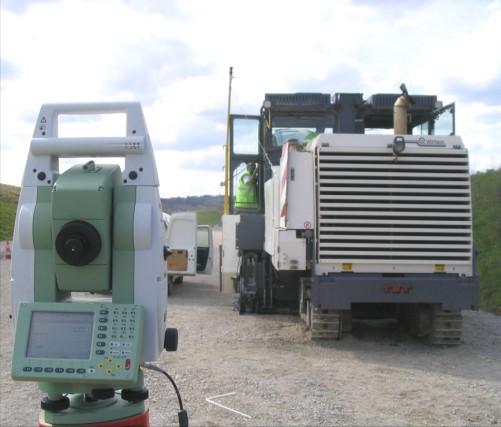
1 Stringless Concrete Paving STRINGLESS CONCRETE PAVING ACPA BUS TOUR AUGUST 5, 2015 Presentation Overview 1) Manufactures 2) Components needed for Stringless Paving 3) Conventional Methods VS Stringless Methods 4) How it works? 5) Questions 1


2 MANUFACTURES OF STRINGLESS PAVING COMPONENTS There are multiple manufactures that developed Stringless Technology. Leica Was the first to develop stringless concrete paving. Late 1990 s Wirtgen-2010 Trimble Topcon Mainline Slipform Paving 2

3 TYPES OF STRINGLESS APPLICATIONS Mainline Slip-forming Curb & Gutter, Barrier Milling MAINLINE PAVING 3


4 CURB & GUTTER & OFFSET PAVING MILLING APPLICATIONS 4
5 WHAT IS LEICA PAVESMART 3D? External Control system developed by Leica Geosystems specifically for stringless concrete paving. Works with a variety of Concrete Paver Manufactures Gomaco Guntert and Zimmerman Power Curbers Wirtgen Vogele Controls the steering and elevation of the concrete paver by the use of 3D models and robotic total stations. SYSTEM BENEFITS... Removes stringlines and conventional survey pins from the jobsite Eliminates the drilling, pounding, & surveying in pins to base the string elevation Eliminates material costs and transport for posts, wands, and string Eliminates bumps to the string during operation Increases jobsite safety & Opens up truck routes within work area The survey instruments included give the ability to measure before and after your paving for exact quality control 5
6 The stringline is virtually created, and put right on the machine computer Create 3D Models in all Major CAD Software packages No waiting for surveying before production Significantly reduces over-milling, over-pouring. (during overlay projects) Increases productivity, quality and performance bonuses Controls Machine height, slope, steering automatically Allows for digitally fine tuning your machine to move as you want Allows for you to override automatics and change alignment or profile on the fly Improves material yields Posted system accuracies of.01 SYSTEM BENEFITS CONT. Typical Mainline Paver System (5) 1 Robotic Total Stations 3-4 are typically dedicated to tracking the machine. Need at least 2 to operate the machine. 1 is typically utilized as a checking tool behind the machine (4) Backsight Setups that sit over control points that set up total stations (1) Grade Checking Rod with Hand-held controller that checks grade, and measures points. It also reports station, offset, and cut/fill information (1) Machine Computer/Software Rugged on-board computer with PaveSmart3D Software (1) Machine Installation Kit-incl. cables/paver prisms/slope sensors 6
 (600ft/200m total) Synchronized EDM/Hz/V data Fully robotic operation Automatic prism tracking Runs VIVA Software")

7 SYSTEM MAIN COMPONENTS ROBOTIC TOTAL STATIONS LEICA VIVA TS15 (TRACKING THE MACHINE OR GRADE CHECKING) 1 total station Used For all Surveying & Machine Control applications 12Hz measurement rate Tracking accuracy 1/8 at 300 ft (±3mm at 100m Typical working Range 300ft (± 100m ) (600ft/200m total) Synchronized EDM/Hz/V data Fully robotic operation Automatic prism tracking Runs VIVA Software interface same as Data Collector SYSTEM MAIN COMPONENTS CONT. Leica CS15 Data Collector Runs VIVA Software for Data Collection, Surveying, or Grade Checking Runs on Windows Mobile Operating System SD, CF, and USB Ports available Full VGA display i.mx ARM core processor Antenna Radio communication with the LRBT Radio Handle, which makes this control any TS15 Total Station Internal Digital Camera for site photos Docking/Charging Station Lemo Port on bottom for USB Connection to PC, or direct connect to GPS Receivers 7


8 SYSTEM MAIN COMPONENTS LEICA MPC1310 MACHINE COMPUTER Rugged Housing SVGA Colour Touch screen Microsoft Windows Embedded Operating Temp. Range -20 C to +60 C MilSpec connectors Remote Access via Internet Power max 2A, 9-30VDC CE & FCC approved IP65 Housing Daylight-readable display Freewave Radios USB Port 4 x RS232 Ports CANBus & Power System Main Components Layout of Stringless Components Computer & Radios Prisms Slope Sensors Secondary Total Station Primary Total Station Leica PaveSmart 3D v3.0 Jan

 Rugged 360deg Prisms 2.) On-Machine Computer w/ PaveSmart3D 3.")
9 System Main Components Layout of Stringless Components Prism Prism Machine Computer and Radios Slope Sensors Leica PaveSmart 3D v3.0 Jan System Main Components On-Machine Components 1.) Rugged 360deg Prisms 2.) On-Machine Computer w/ PaveSmart3D 3.) Dual Axis Slope Sensors Leica PaveSmart 3D v3.0 Jan


10 Workflow for String-Line Conventional Paving... Survey uses a total station to set pins with fill values to the top of concrete every 25 outside of the pave lane Then drilling, and pounding in stakes, and installing tension clamps/wands for line and measuring up to grade to set the string at each survey pin Fine tune string by eye for smoothness Set machine in place and adjust wand sensors into position to trace the string line Contractor is ready to pave to the string line with breaks every 25! Ensure (or hope!) nothing disturbs or damages string lines during paving Leica PaveSmart 3D v3.0 Jan Leica PaveSmart 3D v3.0 Jan

11 Leica PaveSmart 3D v3.0 Jan Stringline VS CAD Based Road Models... Stringline = approximation True Vertical Curves Improved Thickness/Smoothness, no pin bumps Levelling, Eyeballing & Tensioning adds error Horizontal Curve Chording Wastes Concrete Leica PaveSmart 3D v3.0 Jan
 Surveyor Sets Control Points every 500-750 of each side of the")
 Masts on the machine (15 minutes) Contractor is ready to Pave. Automatically!")
12 Workflow for String-Less Paving... BEFORE PROJECT BEGINS: Contractor Builds a 3D model of the concrete edge lines (Virtual Stringline) Surveyor Sets Control Points every of each side of the road Contractor Calibrates the Paver ON PAVE DAY: Contractor sets up (2) total stations backsights the instruments based on the surveyors control points and tracks the (2) Masts on the machine (15 minutes) Contractor is ready to Pave. Automatically! ** Contractor sets up (2) total stations every 500 and leap-frogs to each setup as the paver gets there throughout the pave day Leica PaveSmart 3D v3.0 Jan Leica PaveSmart 3D v3.0 Jan Paver Calibration 12
13 How to Build the Model... All major CAD platforms produce files for Leica PaveSmart 3D Most Modeling Software Packages can generate a.dxf file of the long-slope lines of the road. You load this dxf file into the data collector and it converts it to a.dbx format which can be staked for Station, Offset, and Cut Fill to top of concrete, great info! Leica PaveSmart 3D v3.0 Jan How to Build the Model... All major CAD platforms produce files for Leica PaveSmart 3D CAD System Leica PaveSmart 3D v3.0 Jan
14 Site Control Points MACHINE CONTROL is only as good as the PROJECT SURVEY CONTROL CP 5 Need to have a control point file to setup the total stations. Fore each of the Control points we need the following: CP 4 1. Point Number CP 6 2. Northing 3. Easting 4. Elevation CP 2 CP 3 CP1 With this information, we can setup total stations anywhere we want based on the survey information provided. Leica PaveSmart 3D v3.0 Jan Setting up the Total Stations... Free Station Resections C L XYZ=? XYZ ± 0.01 Backsight Setup on a Control Point Leica PaveSmart 3D v3.0 Jan

15 Survey Control & System Accuracy Leica PaveSmart 3D v3.0 Jan Machine Control is only as accurate as the Survey Control! High-order, well-braced network essential. ±0.01ft in Z & ±0.03 ft XY is our published accuracy for slipforming ±0.02 ft in Z & ±0.03 ft in XY is our published accuracy for milling Dependent on Accurate Survey Control Insist control is available for 3- or 4-point Resections anywhere on the project When setting up instrument, always use at least two control points from the previous setup. Always need line of sight to the paver prisms. Be aware of truck routes and other obstructions that may block sight from total station. The Working Screen... Dashboard (Status & Warnings, Troubleshooting) Production Monitoring Position Control Outputs Project Plan View (click for string selection) Operator Menu Clean, simple, machine-like user interface All essential production information available at-a-glance Varies according to application requirements (asphalt/milling/concrete) Leica PaveSmart 3D v3.0 Jan
 all over the site indicating")


16 Once the contractor is paving stringless There are not reference points (survey pins) all over the site indicating where the line and grade of the concrete should be 2. Tape measure will only tell how thick the slab is How do you check what s going on? Is the slab where it should be Horizontally? Is the slab at the right elevation? Leica PaveSmart 3D v3.0 Jan The answer is to use the same technology... Total Station Road Stakeout 16

17 Questions?? 17
Stringless Paving, Where we are today
 Stringless Paving, Where we are today Anthony Cerisano Vice President Flores Automation & Machine Control 949.923.8966 / acerisano@floresautomation-mc.com February 11, 2016 Presentation Outline 1. Flores
Automatic 3D control system for SP 15 / SP 15 i / SP 25 / SP 25 i. AutoPilot 2.0
 Automatic 3D control system for SP 15 / SP 15 i / SP 25 / SP 25 i. AutoPilot 2.0 02 03 AutoPilot 2.0 the innovative 3D control system The use of standard 3D machine control systems for the production of
OCTOBER OTEC Session 75 Stringless 3D Paving
 OCTOBER 03 2018 OTEC Session 75 Stringless 3D Paving Introductions Brian E Girouard, Trimble Inc Sales Engineer Paving Specialist Manager brian_girouard@trimble.com Brad Cunningham, SITECH Ohio SITECH
Advanced Use of Automatic Grade Controls. Jeroen Snoeck Segment Manager Paving Trimble Navigation Ltd.
 Advanced Use of Automatic Grade Controls Jeroen Snoeck Segment Manager Paving Trimble Navigation Ltd. Contents Industry trends driving technology in Heavy & Highway Construction Traditional Grade Control
3D Milling. Tom Abell
 3D Milling Tom Abell Trimble & 3D Milling as Part of the Resurfacing Process Design Measure Resurfacing From initial survey to finish surface Mill Compact Pave Content Data acquisition Creating data models
3D Stringless Paving
 Tennessee Concrete Pavement and Cement-Based 2014 Pavement Solution Conference 3D Stringless Paving Presented by Robbie Pope, PE GOMACO Corp Ida Grove Iowa Stringless 3D System Presentation Overview What
Leica PowerGrade Intelligent Grading Systems
 Leica PowerGrade Intelligent Grading Systems Leica PowerGrade Leica PowerGrade, the next-generation grade control systems from Leica Geosystems can revolutionise your construction process. It not only
Leica Viva TS11 & TS15 Hardware
 Leica Viva TS11 & TS15 Hardware Contents 1. Introduction 2. Product Variants 3. Side Cover 4. Display and Keyboard 5. Environmental Rating 6. Telescope 8. Operating System & Software 9. Summary 1. Introduction
General GPS TPS ROB X POLE VOL RDN RPL Jobs management System settings (units, precision, parameters, etc.)
") XPAD Survey Modules XPAD Survey GPS TPS XPOLE General GPS TPS ROB XPOLE VOL RDN RPL Jobs management System settings (units, precision, parameters, etc.) Instruments GPS GPS TPS ROB XPOLE VOL RDN RPL Instrument
XPAD Survey Modules XPAD Survey GPS TPS XPOLE General GPS TPS ROB XPOLE VOL RDN RPL Jobs management System settings (units, precision, parameters, etc.) Instruments GPS GPS TPS ROB XPOLE VOL RDN RPL Instrument
Provided by Xpert Survey Equipment Click Topcon GPT-8003A for Product Info and Updated Pricing GPT-8000A/GTS-810A SERIES AUTO TRACKING TOTAL STATION
 Provided by Xpert Survey Equipment Click Topcon GPT-8003A for Product Info and Updated Pricing GPT-8000A/GTS-810A SERIES AUTO TRACKING TOTAL STATION The Solo Survey System that puts you in control The
Leica Viva SmartWorx Viva on TS
 Leica Viva SmartWorx Viva on TS Contents 2. Volumes 3. Check & Adjust 4. CS Connection Wizard 5. Robotic Screen 6. Summary 2 Contents 2. Volumes 3. Check & Adjust 4. CS Connection Wizard 5. Robotic Screen
Trimble 2D Paving Control System for Pavers
 Trimble 2D Paving for Pavers PCS400 2D Paving Key Advantages The only large 2D paving display is easy to learn operate Split screen option allows one operator to easily monitor both sides of the screed
Leica icon grade Intelligent grading systems NEW. igd4 SP System. i n telligent COnstruction
 Leica icon grade Intelligent grading systems NEW igd4 SP System i n telligent COnstruction Leica icon grade Maximize productivity, speed & flexibility The Leica icon grade solutions can revolutionize your
Leica Captivate. Software Release Notes. Field Controllers: CS20, CS35 Total Stations: TS16, TS60, MS60. Release date 5 th March 2018
 Leica Captivate v3.20 Software Release Notes Product Leica Captivate Field Controllers: CS20, CS35 Total Stations: TS16, TS60, MS60 Release date 5 th March 2018 Maintenance date 5 th March 2018 Available
Trimble SCS900 Site Controller Software for Beginners. Jordan Lawver HCC-6339
 Trimble SCS900 Site Controller Software for Beginners Jordan Lawver HCC-6339 Agenda What is Trimble SCS900 Site Controller Software? Who uses SCS900 Trimble Site Positioning System software portfolio Applications
Leica FlexField plus & Leica FlexOffice A Perfect Match
 Leica FlexField & Leica FlexOffice A Perfect Match FlexField Onboard Software General File Management Data Import Data Export Status icon bar Instrument Protection with PIN Stake Out beep Map Select Programs
USER GUIDE. Trimble SCS900 software
 USER GUIDE Trimble SCS900 software Version 3.5.1 Revision A April 2016 1 Corporate Office Trimble Navigation Limited 935 Stewart Drive Sunnyvale, CA 94085 USA www.trimble.com Heavy Civil Construction Division
Survey Pro Software. Includes Spectra Precision Central: Spectra Precision s cloud computing solution. Survey Pro: Simply The Best
 Survey Pro Software Includes Spectra Precision Central: Spectra Precision s cloud computing solution. Survey Pro: Simply The Best SURVEY PROSimplicity, Reliability, and Security Spectra Precision Ranger
Innovative solutions from VÖGELE for working with 3D systems
 A WIRTGEN GROUP COMPANY 3D Machine Control Systems Innovative solutions from VÖGELE for working with 3D systems 3D Machine control systems: More than just sensors 3D in action VÖGELE 3D control systems
TECHNICAL NOTES SURVEY PRO WITH TSX
 SURVEY PRO WITH TSX TECHNICAL NOTES Survey Pro software from TDS is the data collection solution of choice for most North American surveyors 1. And with the addition of the Trimble TSX (Trimble Systems
2D CONSTRUCTION SOLUTIONS
 2D CONSTRUCTION SOLUTIONS 2D CONSTRUCTION SOLUTIONS Keep your projects on time and under budget. We have the leadingedge hardware, software, and mobile solutions you need to increase efficiency, improve
Microwave. Infrared. Preprogrammed Chip
 Advanced Technology for Design Mapping and Construction Layout AACE A.A.C.E. Meeting August 5, 2009 Daniel K. Mardock RBF Consulting Survey Manager Registered Land Surveyor Certified Federal Surveyor Arizona
2D CONSTRUCTION SOLUTIONS
 2D CONSTRUCTION SOLUTIONS 2D CONSTRUCTION SOLUTIONS Keep your projects on time and under budget. We have the leadingedge hardware, software, and mobile solutions you need to increase efficiency, improve
TECHNICAL NOTES TRIMBLE SURVEY CONTROLLER SOFTWARE
 TRIMBLE SURVEY CONTROLLER SOFTWARE TECHNICAL NOTES The Trimble Survey Controller software is the data collection solution that will make your survey work faster, easier, and more productive than ever before.
Evidence Recorder Release Notes
 Evidence Recorder 6.0.0 Release Notes Released on: October 5, 2009 Licensing Changes This release has had one big change and that is a new licensing system that gives us more flexibility to add different
Leica Captivate. Software Release Notes. Field Controllers: CS20, CS35 Total Stations: TS16, TS60, MS60. Release date 1 st December 2017
 Leica Captivate v3.00 Software Release Notes Product Leica Captivate Field Controllers: CS20, CS35 Total Stations: TS16, TS60, MS60 Release date 1 st December 2017 Maintenance date 1 st December 2017 Available
FieldGenius 2005 Ver 1.2 MicroSurvey Software, Inc. 2005
 New Functionality GPS Measurements Two new options in Program Settings that will speed up the measurement process when using an RTK receiver. Auto GPS Stats If this is turned on, during a measurement if
Grade Control. GRADE CONTROL SYSTEMS Topcon. MOTOR GRADER 3D-GPS+, mmgps Plug-and-Play. HYDRAULIC EXCAVATOR X63 3D-GPS+ Plug-and-Play
 GRADE CONTROL SYSTEMS Topcon Grade Control CRAWLER DOZER 3D-MC 2 Plug-and-Play HYDRAULIC EXCAVATOR X63 3D-GPS+ Plug-and-Play MOTOR GRADER 3D-GPS+, mmgps Plug-and-Play PHOTOS MAY INCLUDE OPTIONAL EQUIPMENT
TcpTunnel. Setting Out and Surveying for Tunnels. Introduction. Project Definition
 TcpTunnel Setting Out and Surveying for Tunnels Introduction This application, installed in a mobile device, provides users with the most common options for setting out tunnels and gathering data from
Leica FlexLine TS09plus Full Precision at High Performance
 Leica FlexLine TS09plus Full Precision at High Performance The First Plus: Original Leica Geosystems Quality For most, quality is relative. Not so at Leica Geosystems. To ensure our instruments meet the
FEBRUARY Trimble PCS900 3D Milling & 3D Paving
 FEBRUARY 2018 Trimble PCS900 3D Milling & 3D Paving Presenter Kevin Ackley Sitech Michigan Why use 3D Milling and 3D Paving? To build better pavement Structures!!! Sample Engineering Specifications 2D
Leica icon grade Intelligent grading solutions
 Leica icon grade Intelligent grading solutions intelligent CONstruction leica-geosystems.com Leica icon grade igd2 and igd3 Complete 2D and 3D solutions for all large earth moving projects igd2, icon grade
TRIMBLE PAVING SOLUTIONS MILL FILL
 TRIMBLE PAVING SOLUTIONS MILL FILL better from the ground up Today s road projects require contractors to work faster, with better accuracy, and with tighter control on costs. For the paving contractor,
Trimble Grade Control Systems GCS900 2D for Motor Graders
 GCS900 2D for Motor Graders Trimble offers the heavy and highway contractor the broadest range of Grade Control Systems in the industry. From 2D laser or sonic based to 3D GNSS or Total Station based,
LEICA MobileMatriX Equipment List
 LEICA MobileMatriX LEICA MobileMatriX software 742117 GSW450, LEICA MobileMatriX License. Single user license for Standard Edition. ESRI ArcView OEM. Protected. COGO computation and rendering of COGO measurements
Provided by Xpert Survey Equipment Click Topcon GPT-8205A for Product Info and Updated Pricing GPT-8200A/GTS-820A SERIES AUTO TRACKING TOTAL STATION
 Provided by Xpert Survey Equipment Click Topcon GPT-8205A for Product Info and Updated Pricing GPT-8200A/GTS-820A SERIES AUTO TRACKING TOTAL STATION The Solo Survey System that puts you in control The
technical notes Trimble survey controller field software
 Trimble survey controller field software technical notes For more than a decade, Trimble Survey Controller field software has provided land surveyors with a complete GNSS and optical data-collection solution
Increase Field Survey Efficiency by Merging Technologies in NOVA MultiStation. Vincent Lui Leica Geosystems Ltd
 Increase Field Survey Efficiency by Merging Technologies in NOVA MultiStation Vincent Lui Leica Geosystems Ltd Advantages of Laser Scanning Advantages of TPS Measurements Advantages of Imaging Advantages
Leica FlexLine TS06plus Top precision meets high efficiency
 Leica FlexLine TS06plus Top precision meets high efficiency The First Plus: Original Leica Geosystems quality For most, quality is relative. Not so at Leica Geosystems. To ensure our instruments meet the
3DMC Reference Guide
 P O S I T I O N I N G S Y S T E M S 3DMC Reference Guide Part Number 7010-0911 Rev. C Copyright Topcon Positioning Systems, Inc. September, 2010 All contents in this manual are copyrighted by Topcon. All
Trimble. S6 Total Station. Demonstration Guide
 Trimble S6 Total Station Demonstration Guide Version 1.00 Revision A Part Number 022543-106 January 2005 Contact Information Trimble Geomatics and Engineering Division 5475 Kellenburger Road Dayton, Ohio
Leica FlexLine plus. Product Presentation V4.00
 Leica FlexLine plus Product Presentation V4.00 Leica FlexLine plus Table of contents 1. FlexLine plus - Product Concept 2. FlexLine plus - Hardware Features 3. FlexField plus - Onboard Firmware 4. FlexLine
Trimble Total Station Manual R 200 READ ONLINE
 Trimble Total Station Manual R 200 READ ONLINE SPS620 and SPS720 Robotic Total Stations Trimble Heavy - SPS620 and SPS720 Robotic Total Stations Locate a Dealer. Request a Demo. Main Tab Connect your office
Landfill Grading Using GPS Machine Control
 Landfill Grading Using GPS Machine Control NC SWANA April 2018 Presented by: Bernie Garrett, PE Garrett & Moore Inc. & Gabe Leach Cooper Barnette & Page Inc. 1 Purpose Work flow processes used by Engineers,
Perpendicular Offsets - point picker is a check-box type button and will now remain in effect until switched off.
 New Functionality Raw File Viewer This now has a View button that allows the user to see the map in a split view. Tapping on certain records will show up as icons in the view. For example tapping an OC
REFERENCE. Section 6. Field Use Tutorial 2-1
 REFERENCE Section 6 Field Use Tutorial 2-1 REFERENCE 2-2 Field Use Overview RTK GPS support is an additional feature in Sitework 4D, which must be purchased separately. In addition to creating takeoffs
Trimble Productivity: Finish Faster with Fewer Machines. TRIMBLE GCS900 GRADE CONTROL SYSTEMS
 Trimble Productivity: Finish Faster with Fewer Machines. TRIMBLE GCS900 GRADE CONTROL SYSTEMS TAKE ThE GUESSWORK OUT OF EARThWORKS. ONLY FROM ThE LEADER. TRIMbLE. The Connected Construction Site An interesting
3D System. 2D & 3D Systems. Compact Attachments
 3D System 2D & 3D Systems 1 2D System 2D System Systems work off a single plain Flat Single slope Dual Slope Bobcat laser system is 2D 2 Sonic 3 3D System 3D System Works off elevation coordinates setup
Leica Rugby 810, 820 & 840 The toughest construction lasers on site
 Leica Rugby 810, 820 & 840 The toughest construction lasers on site Leica Rugby The toughest construction lasers on site Leica Rugby construction lasers are more than just a product, they are an intelligent,
Pave the Way to Better Profits. Trimble. Paving Solutions TRANSFORMING THE WAY THE WORLD WORKS
 Pave the Way to Better Profits Trimble Paving Solutions TRANSFORMING THE WAY THE WORLD WORKS Solutions for the Complete Paving Job Site Productive, integrated and innovative solutions to keep you on track
X-PAD Ultimate. The Ultimate solution in the field. Works when you do
 Works when you do X-PAD Ultimate The Ultimate solution in the field X-PAD Ultimate is a tailored, flexible, modular, ideal, customised software for high end topographic tasks, such as measure, stake-out,
Site calibration improvements for GPS operations. Stakeout line changes. Call API toll free (888)
") Welcome to the Q4 Edition of the API Newsletter. This newsletter is being presented as an information tool to present new product information. If there are any questions regarding any products or services
Welcome to the Q4 Edition of the API Newsletter. This newsletter is being presented as an information tool to present new product information. If there are any questions regarding any products or services
Leica DISTO S910 Measure point data and create plans
 Leica DISTO S910 Measure point data and create plans The world s first Measure anything from anywhere with P2P Technology It s been over 20 years since Leica Geosystems launched the first hand-held laser
3-D MODELING FOR MACHINE CONTROL
 SHELLY & SANDS JOHN DOWALTER, PE, PS 3-D MODELING FOR MACHINE CONTROL Dale Carnegie Public Speaking Training Ben Stein s Public Speaking Training SHELLY & SANDS JOHN DOWALTER, PE, PS S&S Survey Manager
Release 4.1. Description
 Leica MobileMatriX Release 4.1 Products - Options Packages - Hardware Description Leica MobileMatriX 4.1 Leica Geosystems, 2004-2010 1 PRODUCTS Three different Editions are available: Standard Edition
Trimble Survey Controller. Release Notes
 Trimble Survey Controller Release Notes Version 10.5 Revision A September 2002 Corporate Office Trimble Navigation Limited Engineering and Construction Division 5475 Kellenburger Road Dayton, Ohio 45424-1099
James Schneider Advanced Materials and Technology
 (CEC-90153) Minnesota DOT Deploy GCS900, Business Center HCE and VisionLink with the DOTs GEOPAK software to automatically monitor large scale excavation in Carver County James Schneider Advanced Materials
TRIMBLE GPS SEARCH TECHNOLOGY FOR THE PROFESSIONAL SURVEYOR
 TRIMBLE GPS SEARCH TECHNOLOGY FOR THE PROFESSIONAL SURVEYOR BY TIM LEMMON AND CHRIS VAN DER LOO, TRIMBLE APPLICATIONS SPECIALISTS, WESTMINSTER, COLORADO, U.S.A. ABSTRACT The Global Positioning System (GPS)
Leica Builder... Built to Build
 Leica Builder... Built to Build Leica Builder... Built to Build Instead of tediously setting up strings, with the Builder T100 my masons can start work right away. The Builder T100 or T200 can determine
Leica Rugby 810, 820 & 840 The toughest construction lasers on site
 Leica Rugby 810, 820 & 840 The toughest construction lasers on site Leica Rugby The toughest construction lasers on site Leica Rugby construction lasers are more than just a product, they are an intelligent,
Leica TPS800 Series Powerful, efficient, reliable and intuitive. PinPoint Technology
 Leica TPS800 Series Powerful, efficient, reliable and intuitive PinPoint Technology powerful Leica TPS800 Performance Series... Three classes of accuracy TPS800 total stations are available in angular
SCS900 SITE CONTROLLER SOFTWARE USER GUIDE
 SCS900 SITE CONTROLLER SOFTWARE USER GUIDE Version 3.61 Revision A July 2017 Corporate Office Trimble Inc. 935 Stewart Drive Sunnyvale, CA 94085 USA www.trimble.com Product Limited Warranty Information
TRIMBLE ASPHALT PAVING SOLUTIONS
 TRIMBLE ASPHALT PAVING SOLUTIONS Mill Fill better from the ground up Today s road projects require contractors to work faster, with better accuracy, and with tighter control on costs. For the paving contractor,
Leica Builder... Built to Build
 Leica Builder... Built to Build Leica Builder... Built to Build Instead of tediously setting up strings, with the Builder T100 my masons can start work right away. The Builder T100 or T200 can determine
Reality Capture using: RPAS Technologies & Image Laser Scanners
 Reality Capture using: RPAS Technologies & Image Laser Scanners by Johan Erasmus (RPAS Technologies) & Barend Bornman (Image Laser Scanners) from Aciel Geomatics Laser Scanners High-Definition Surveying
OPTIMIZING 3D SURFACE CHARACTERISTICS DATA COLLECTION BY RE-USING THE DATA FOR PROJECT LEVEL ROAD DESIGN
 OPTIMIZING 3D SURFACE CHARACTERISTICS DATA COLLECTION BY RE-USING THE DATA FOR PROJECT LEVEL ROAD DESIGN Benoit Petitclerc, P.E. John Laurent, M. Sc Richard Habel, M. Sc., Pavemetrics Systems Inc., Canada
Kevin Garcia and Brian Girouard February Machine Control Technology in Milling and Paving
 Kevin Garcia and Brian Girouard February 2017 Machine Control Technology in Milling and Paving Brian E Girouard, Milling Paving Compaction Specialist Civil Engineering & Construction Americas Trimble Navigation
Survey Pro Software. Field Proven Data Collection with Survey Pro Software
 Survey Pro Software Field Proven Data Collection with Survey Pro Software SURVEY PROSimplicity, Reliabilty, and Security Spectra Precision Survey Pro software gives you a complete set of tools for all
Leica Captivate. Software Release Notes. Field Controllers: CS20, CS35 Total Stations: TS16, TS60, MS60, TS13 GNSS Sensors: GS18 T
 Leica Captivate v4.10 Software Release Notes Product Leica Captivate Field Controllers: CS20, CS35 Total Stations: TS16, TS60, MS60, TS13 GNSS Sensors: GS18 T Release date 10 th December 2018 Maintenance
Leica FlexLine TS06plus Top Precision meets High Efficiency
 Leica FlexLine TS06plus Top Precision meets High Efficiency The First Plus: Original Leica Geosystems Quality For most, quality is relative. Not so at Leica Geosystems. To ensure our instruments meet the
3DMC / 3DXi Create a network equipment configuration. 2. Enter IP address & NTRIP information.
 3DMC / 3DXi 6.11.03 1. Added Network & Modem Support Added support for Wavecom and SmallTouch modems. Added RTCM 3.0 support Improvements made connecting to GPS networks. Network setup example: 1. Create
Quick Reference Card
 with the FieldLevel II Automated Levelling System Quick Reference Card f g h i j e Run screen layout d c l m n o p q r k s Item Description Item Description c d e Cut / Fill map The difference between
Trimble Grade Control Systems GCS900 2D for Motor Graders
 GCS900 2D for Motor Trimble offers the heavy and highway contractor the broadest range of Grade Control in the industry. From 2D laser or sonic based to 3D GNSS or Total Station based, Trimble systems
Trimble Engineering & Construction Group, 5475 Kellenburger Road, Dayton, OH , USA
 Trimble VISION Ken Joyce Martin Koehler Michael Vogel Trimble Engineering and Construction Group Westminster, Colorado, USA April 2012 Trimble Engineering & Construction Group, 5475 Kellenburger Road,
DASHBOARD OPERATION MANUAL. Machine Control, Inc.
 DASHBOARD OPERATION MANUAL Machine Control, Inc. INTEGRATE YOUR DATA With highly accurate topographic data describing your job site, its easy to envision and design a multiphase system to address your
3D Technology in the Construction Continuum. Alabama DOT Pre-Construction Conference Montgomery AL May 03, 2016
 3D Technology in the Construction Continuum Alabama DOT Pre-Construction Conference Montgomery AL May 03, 2016 Brian E Girouard, Sales Engineer, Milling-Paving-Compaction Specialist Civil Engineering &
Trimble Grade Control Systems GCS900 2D for Dozers
 GCS900 2D for Dozers Trimble offers the heavy and highway contractor the broadest range of Grade Control Systems in the industry. From 2D depth, slope, and elevation based to 3D GNSS or Total Station based,
3-D Modeling Implementation
 3-D Modeling Implementation Presented January 31, 2013 Douglas Townes FHWA Resource Center WORKFLOW FOR ELECTRONIC DATA TRANSFER WHEN USING AMG IN CONSTRUCTION Charles Jahren, PhD Iowa State University
The Fieldbook - Objectives
 The Fieldbook - Objectives Review the on-line Survey Fieldbook Stations Observations Searching in the Fieldbook Editing the Fieldbook Adding Entries Selecting Data in the Fieldbook from graphics Page 1-1
Trimble. LM80 Layout Manager A BLUEPRINT FOR SUCCESSFUL LAYOUT. Easy to Use Increased Productivity Minimum Errors and Rework Maximum Reliability
 Trimble LM80 Layout Manager A BLUEPRINT FOR SUCCESSFUL LAYOUT Easy to Use Increased Productivity Minimum Errors and Rework Maximum Reliability In a Class of its Own The Trimble LM80 is a revolutionary
A Precise Finish Grade in a Fraction of the time
 A Precise Finish Grade in a Fraction of the time INSIDE FRONT www.lasergrader.co.uk A Precise Finish Grade in a Fraction of the time Specification Overall Length (to front blade) 3.81m Overall Width
Provided by Xpert Survey Equipment Click Leica TS06 for Product Info and Updated Pricing. Leica FlexLine TS06plus Top precision meets high efficiency
 Provided by Xpert Survey Equipment Click Leica TS06 for Product Info and Updated Pricing Leica TS06plus Top precision meets high efficiency The First Plus: Leica Geosystems quality For most, quality is
TPS1100 Professional Series
 20 30 40 50 TPS1100 Professional Series Application programs Field Manual 2 English Version 1.0 The quick way to start with the TPS1100 Programs. 2 For additional details on single TPS1100 application
Leica Rugby 320 SG & 410/420 DG The toughest players on big fields
 Leica Rugby 320 SG & 410/420 DG The toughest players on big fields Provided by Xpert Survey Equipment Click Leica Rugby 420DG for Product Info and Updated Pricing n Construction n Machine Control n Agriculture
Leica System 1200 Software Integrated Software for GPS1200 and TPS1200
 Leica System 1200 Software Integrated Software for GPS1200 and TPS1200 Leica System 1200 Software System 1200 software includes SmartWorx the onboard TPS, GPS and RX1250 software and the Leica Geo Office
GCS900 GRADE CONTROL SySTEmS LK Bu RADE G FINISH
 GCS900 GRADE CONTROL Systems BulK Grade take the guesswork out of earthworks Trimble sets the standard for construction technology by developing highly productive, integrated and innovative solutions for
Session Objectives. Describe how 3D Models are created during design. Discuss what 3D Model outputs are useful in Construction
 1 Session Objectives Describe how 3D Models are created during design Discuss what 3D Model outputs are useful in Construction Describe applications of 3D Models in Construction 2 Creating the 3D Design
Leica High-Definition Surveying Systems. Leica HDS3000. The Industry Standard for High-Definition Surveying
 Leica High-Definition Surveying Systems Leica HDS3000 The Industry Standard for High-Definition Surveying HDS High-Definition Surveying TM : Laser Scanning Redefined High-Definition Surveying, or HDS,
The Leica HDS Family. The Right Tool for the Job HDS3000 HDS2500 HDS4500. Cyclone & CloudWorx. Press the QuickScan button to define the field-of-view.
 HDS2500 High accuracy scanner, ideal for fixed or raised installations when leveled tripod mounting is not practical, or areas with less stringent field-of-view requirements. The Leica HDS Family Time-of-flight
FieldGenius 2010 Release Notes
 FieldGenius 2010 Release Notes This document contains the release notes for all FieldGenius 2010 releases. The latest release notes can be found at the end of the document. FieldGenius 2010 4.2.0 (Released
TechnicalNotes. Trimble Survey Controller v10.0 Software THE ADVANCED TOTAL FIELD SOLUTION FROM TRIMBLE
 TechnicalNotes Trimble Survey Controller v10.0 Software THE ADVANCED TOTAL FIELD SOLUTION FROM TRIMBLE The Trimble Survey Controller software utilizes more of your senses to make your survey work faster,
TECHNOLOGY SOLUTIONS TRANSFORMING CONSTRUCTION LAYOUT. Trimble Field Link TRANSFORMING THE WAY THE WORLD WORKS
 TECHNOLOGY SOLUTIONS TRANSFORMING CONSTRUCTION LAYOUT Taking full advantage of the Trimble Tablet s processor and multi-touch screen functionality, has been designed to work the way you work. Featuring
Leica Onboard Slope Monitoring Manual Module 6
 Leica Onboard Slope Monitoring Manual Module 6 Manual Version 3.5 Softrock Solutions specialise in slope monitoring. We have developed software and systems that will assist you with your slope monitoring
DATA COLLECTORS FC-100 / FC-2000
 FC-100 / FC-2000 DATA COLLECTORS Topcon Field Computers; FC-100 and FC-2000 Compact, ultra bright, sealed and sturdy field computers. The demands of modern field data collection and control have changed
Route Surveying. Topic Outline
 Route Surveying CE 305 Intro To Geomatics By Darrell R. Dean, Jr., P.S., Ph.D. Topic Outline Horizontal alignment Types of Horizontal Curves Degree of Curve Geometric elements of curve Station ti number
Protect by Leica Geosystems A Lifetime Guarantee
 Protect by Leica Geosystems A Lifetime Guarantee Protect by Leica Geosystems We always protect your success PROTECT by Leica Geosystems Lifetime Warranty No Cost Period Certified Quality Swiss Technology
12D LEAST SQUARES NETWORK ADJUSTMENT FROM LEICA 1200
 12D LEAST SQUARES NETWORK ADJUSTMENT FROM LEICA 1200 READINGS The following steps show the conversion of a Leica 1200 DBX file to a horizontal and level network adjustment file and the subsequent adjustments
3DMC Reference Guide
 P O S I T I O N I N G S Y S T E M S 3DMC Reference Guide Part Number 7010-0911 Rev. B Copyright Topcon Positioning Systems, Inc. April, 2010 All contents in this manual are copyrighted by Topcon. All rights
Product Leica Infinity. Date July 13 t, From Kevin Hanson
 Product Leica Infinity Date July 13 t, 2018 From Kevin Hanson Leica Geosystems AG Heinrich-Wild-Strasse CH-9435 Heerbrugg Switzerland www.leica-geosystems.com Table of Contents 1 About Infinity v3.0.1...
12d Model v8 interface to Trimble instruments 2007
 These notes describe the interfacing of 12d version 8 with the Trimble surveying instruments. 1) Installing Trimble link Trimble link must be installed prior to attempting to upload or download data to