CARPATCLIM Date Version Page Report Final version (1)14. Deliverable D1.15
|
|
|
- Hilda May
- 5 years ago
- Views:
Transcription
1 CARPATCLIM Date Version Page Report Final version (1)14 Deliverable D1.15 Implemented drafts version of metadata per country of meteorological stations selected for this project, including the length of record and observed parameters per station Contract number: OJEU 2010/S Deliverable: D1.15 Author: Pavol Nejedlík, Tiberiu-Eugen Antofile, Katarína Mikulová, Pavel Šťastný Date: Version: Final version
2 CARPATCLIM Date Version Page Report Final version (2)14 Content 1. Introduction 2. Metadata gathering and completion 2.1 Station properties 2.2 Variables properties 3. Metada on data rescue and homogenization 3.1 Metadata on data rescue 3.2 Metadata on data homogenization 4. Database design 5. References 6. Annexes 1. Introduction According to the service contract and the proposed deliverables D1.13 and D1.14 an operative tool was designed for metadata storage serving for homogenization and interpolation procedures. 2. Metadata gathering and completion Metadata gathering products consisted from two independent parts: Station properties Variables properties There were two xls files both with 3 sheets designed for tis action; in the first one were general station/variable atributes and properties, in the second the station/variable changes and in the third was a brief help for better understanding of some shortages and acronyms. 2.1 Station properties Station properties file consits from 3 sheets: Station ChangeStationPosition Help
3 CARPATCLIM Date Version Page Report Final version (3)14 In the Station sheet are completed data on meteorological station: NameStation Country Actual Latitude Actual Longitude Actual Altitude NatHyps Basin StatSurr StationType StationCat BegMonStat EndMonStat Variables - Station name - National ID of the station - Country (Country code/abbreviation) - Latitude of up to date position station in WGS84 - Longitude of up to date position station in WGS84 - Altitude of up to date position station in meters a.s.l. - National hypsometric system - Partial basin - Overall character of the surroundings - Data from station type - Station category - Beginning of monitoring station - End of monitoring station o Maximum air temperature o Minimum air temperature o Accumulated total precipitation o 10m wind direction o 10m horizontal wind speed o Sunshine duration o Cloud cover o Global radiation o Relative humidity o Surface vapour pressure o Surface air pressure o Snow depth In the ChangeStationPosition sheet changes of climatological/precipitation station position are documented: NameStation DateChange Original Longitude Original Latitude Original Altitude New Longitude - Station name - National ID of the station - Date of change - Longitude before change position station in WGS84 - Latitude before change position station in WGS84 - Altitude before change position station in meters a.s.l. - Longitude after change position station in WGS84
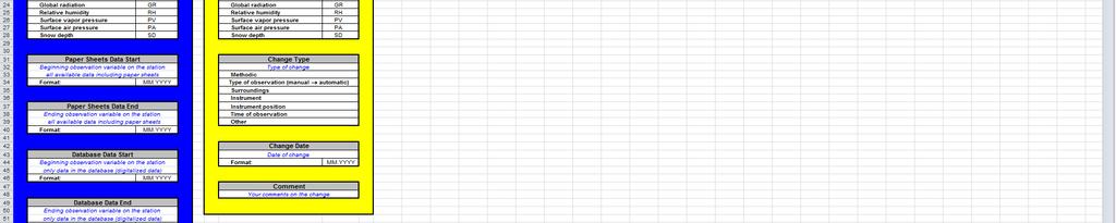
4 CARPATCLIM Date Version Page Report Final version (4)14 New Latitude New Altitude Comment - Latitude after change position station in WGS84 - Altitude after change position station in meters a.s.l. - Comment of the change position In the Help sheet instruction for data completion are stored. 2.2 Variables properties Variables properties file consits from 3 sheets: VariablesProperties ChangeVariables Help In the VariablesProperties sheet the availability, completeness and quality of the individual variables are completed. Following parameters are detected: NameStation Variables - Station name - National ID of the station - Variables name Paper Sheets Data Start - Beginning observation variable on the station all available data including paper sheets Paper Sheets Data End - Ending observation variable on the station all available data including paper sheets Database Data Start - Beginning observation variable on the station only data in the database (digitalized data) Database Data End - Ending observation variable on the station only data in the database (digitalized data) Database Type Data Completeness Quality Control - Type of data in the database - Yes/No - Yes/No Observing Time1 - Time of observation in the morning in the mean local time
5 CARPATCLIM Date Version Page Report Final version (5)14 Observing Time2 Observing Time3 - Time of observation in the midday in the mean local time - Time of observation in the evening in the mean local time Observing Time4 - Time of observation in the night (if practiced)in the mean local time Observing Height - Height of the observing instrument relative to the surface in meters Observing Instrument Observing Type - Type of the observing instrument - Data from station type In the ChangeVariables sheet the changes in time series of the individual variables are recorded. NameStation Variables Change Type Change Date Comment - Station name - National ID of the station - Variables name - Type of change - Date of change - Comments on the change In the Help sheet instruction for data completion are stored. 3. Metada on data rescue and homogenization Metadata on data rescue and homogenization are added value to overall metadata system. With the help of them we are able to identify some artificial elements and procedures in data creation namely the homogenization procedures and results Metadata on data rescue In the Metadata on data rescue sheet the station or variable identification will be primary. The data rescue sheets should be completed with data based on climatological/precipitation station hierarchy: NameStation - Station name - National ID of the station Variable i - Variable name
6 CARPATCLIM Date Version Page Report Final version (6)14 Time interval - Time interval of rescued data Source of data - Data sources (paper sheets, paper strips, year books, other) Completeness - Completeness of rescued data Quality check - Information on QC (Y/N) Comment(s) 3.2. Metadata on data homogenization Metadata on data homogenisation sheet serves for idetification if original or homogenized data are used in the atlas creation. All the data should enable to identify type of procedure and other necessary informations for possible repetition of the homogenization technique step by step and including all relevant information to trace back the processing executed in order to arrive at the current datasets. The Data homogenization sheets will be completed with data based on meteorological station hierarchy: NameStation Variable i - Station name - National ID of the station - Variables name Homogenization procedure - Information on homogenization procedure used (MASH, other) Homogenization type - Type of homogenization (manual, automatic) Reference station(s) - Information on reference station used in homogenization Comment(s) procedure - Other useful information (break point(s), significance level) 4. Schema of the database The schema of the database contains all the basic elements and station attributes that describe station from the wiev of possition, type, data availability, quality and changes in time and space. In the same importace we can obtain useful information on individual variables and changes in the observations/measurements. The same attitude have the metadata on some artificial steps in the data management needed for quality of time series rise or completeness of data namely data rescue and homogenization. In the time of the deliverable D1.15 preparation the actual information on procedures and results are not complete (see Annex 1), so we don t include those specific metadata into the schema of the database, but in parts 3.1 and 3.2 we suggest some structure of them.
7 CARPATCLIM Date Version Page Report Final version (7)14 The metadata database will be filled up with standardised xls files of metadata for stations/variables per country (see Annex 2a 3c). 5. References D1.7 Proposal for quality control tests to be performed for all observational time series, Submitted to JRC. D1.8 Proposal for homogenization methods to be applied to all observational time series, Submitted to JRC. D1.13 Proposal of the metadata profile to be applied to all metadata generated during the project, Submitted to JRC. D1.14 Implemented drafts version of metadata per country of meteorological stations selected for this project, including the length of record and observed parameters per station, Submitted to JRC. EN ISO 19115:2003: Geographic information Metadata INSPIRE Metadata Implementing Rules: Technical Guidelines based on EN ISO and EN ISO 19119, v. 1.1 WMO Core Metadata Profile version 1.2, Guidelines on the use of Metadata for WIS, Geneve, 2010
8 Annex 1. Metadata database scheme Country all Country StatSitting_all Station Sitting StatSurr_all Station Surrounding StatType_all Station Type StatCat_all Station Category StationProperties Country Actual Latitude Actual Longitude Actual Altitude NatHyps Basin StatSitting StatSurr StationType StationCat BegMonStat EndMonStat Variables (list: Y/N) Comment(s) VariablesProperties Variables Paper Sheets Data Start Paper Sheets Data End Database Data Start Database Data End Database Type Data Completeness Quality Control Observing Time1 Observing Time2 Observing Time3 Observing Time4 Observing Height Observing Instrument Observing Type Comment(s) Station NameStation ChangeVariables Change Type Change Date Comment(s) ObsInstrument Observing Instrument ChangeStationPosition DateChange Original Longitude Original Latitude Original Altitude New Longitude New Latitude New Altitude Comment(s) ChangeType Type of change DataRescue (Not ready yet) VARIABLES LIST Maximum air temperature Minimum air temperature Accumulated total 10m wind direction 10m horizontal wind speed Sunshine duration Cloud cover Global radiation Relative humidity Surface vapor pressure Surface air pressure Snow depth Homogenization (Not ready yet)


9 Annex 2a: Station properties xls file, Station sheet example


10 Annex 2b: Station properties xls file, ChangeStationPosition sheet example Annex 2c: Station properties xls file, Help sheet example


11 Annex 3a: Variables properties xls file, VariablesProperties sheet example


12 Annex 3b: Variables properties xls file, ChangeVariables sheet example

13 Annex 3c: Variables properties xls file, Help sheet example


14
Deliverable D3.12. Contract number: OJEU 2010/S Deliverable: D3.12 Author: Igor Antolovic Date: Version: Final
 Deliverable D3.12 Final and public version of the implemented web site with full functionality that hosts all relevant information on the Climate Atlas of the Carpathian Region, including a public download
Climate Metadata Inventory at the National Institute of Meteorology and Hydrology of Bulgaria
 BULGARIAN ACADEMY OF SCIENCES National Institute of Meteorology and Hydrology Climate Metadata Inventory at the National Institute of Meteorology and Hydrology of Bulgaria Tania Marinova, Anelia Gocheva
Format specification for the SMET Weather Station Meteorological Data Format version 1.1
 Format specification for the SMET Weather Station Meteorological Data Format version 1.1 Mathias Bavay November 28, 2017 Abstract The goal of this data format is to ease the exchange of meteorological
Introduction of new WDCGG website. Seiji MIYAUCHI Meteorological Agency
 Introduction of new WDCGG website Seiji MIYAUCHI WDCGG@Japan Meteorological Agency 1. Introduction of new WDCGG website 2. Starting to gather and provide satellite data at WDCGG Current WDCGG website 3
NIAES station agro-meteorological data in Hokuriku, Japan
 NIAES station agrometeorological data in Hokuriku, Japan 1. IDENTIFICATION INFORMATION Metadata Identifier NIAES station agro-meteorological data in Hokuriku, Japan JP_NIAES_MetData_MeteoCrop_AMeDAS_Hokuriku20181216210001-DIAS20180903143952-
Data Management in BMKG. Database Center, BMKG July 11, 2017
 Data Management in BMKG Database Center, BMKG July 11, 2017 Let s think about 4 Everlasting used data The biggest data producer in Indonesia Many data resources Forecaster may false but Data can t! STATION
The descriptions of the elements and measures are based on Annex D of ISO/DIS Geographic information Data quality.
 7 Data quality This chapter includes a description of the data quality elements and sub-elements as well as the corresponding data quality measures that should be used to evaluate and document data quality
MetOcean Themes in INSPIRE
 MetOcean Themes in INSPIRE Cliquez pour modifier le style du titre 4th Workshop on the use of GIS/OGC standards in meteorology Cliquez pour modifier le style des sous-titres Frédéric du Guillaud masque
GidasToSynop User Manual Update 09/29/2016
 GidasToSynop User Manual Update 09/29/2016 Cod. SWUM_00434_en Index 1. Introduction... 3 2. System requirements... 3 3. SYNOP bulletin implementation... 4 3.1. Detail of implemented data groups... 4 3.2.
GidasToSynop User Manual Update 11/11/2008
 GidasToSynop User Manual Update 11/11/2008 Cod. SWUM_00434_en Index 1. Introduction... 3 2. System requirements... 3 3. SYNOP bulletin implementation... 4 3.1. Detail of implemented data groups... 4 3.2.
Global Soil Wetness Project Phase 3 Atmospheric Boundary Conditions (Experiment
 Global Soil Wetness Project Phase 3 Atmospheric Boundary Conditions (Experiment 1) 1. IDENTIFICATION INFORMATION Edition Version 1 Abbreviation DOI Metadata Identifier 2. CONTACT Global Soil Wetness Project
Purpose : Understanding Projections, 12D, and the System 1200.
 Purpose : Understanding Projections, 12D, and the System 1200. 1. For any Cad work created inside 12D, the distances entered are plane (Horizontal Chord) distances. 2. Setting a projection, or changing
CGMS WMO Task Force on Metadata Implementation Progress. Presented to IPET-SUP agenda item 12.2
 CGMS WMO Task Force on Metadata Implementation Progress Presented to IPET-SUP 17-03-2015 agenda item 12.2 Overview CGMS-WMO-Task Force on Metadata Implementation Refresher Why such Task Force Task Force
IMPLEMENTATON OF SOUTHASIA CLIMATE ASSESSMET AND DASET (SACA&D) AT BMKG
 AT BMKG") IMPLEMENTATON OF SOUTHASIA CLIMATE ASSESSMET AND DASET (SACA&D) AT BMKG OUTLINE Introduction of SACAD System Preparation of Implementation Data collecting and reformatting Preparing HW,SW and BW Current
IMPLEMENTATON OF SOUTHASIA CLIMATE ASSESSMET AND DASET (SACA&D) AT BMKG OUTLINE Introduction of SACAD System Preparation of Implementation Data collecting and reformatting Preparing HW,SW and BW Current
Requirements (QASR) - Chapter 6. HYDRO-METEOROLOGIC and HYDRAULIC MONITORING
 - Chapter 6. HYDRO-METEOROLOGIC and HYDRAULIC MONITORING") CERP Quality Assurance Systems Requirements (QASR) - Chapter 6 HYDRO-METEOROLOGIC and HYDRAULIC MONITORING Purpose and Scope Purpose is to provide guidelines for efficient and effective production of hydrologic
CERP Quality Assurance Systems Requirements (QASR) - Chapter 6 HYDRO-METEOROLOGIC and HYDRAULIC MONITORING Purpose and Scope Purpose is to provide guidelines for efficient and effective production of hydrologic
Consolidation Team INSPIRE Annex I data specifications testing Call for Participation
 INSPIRE Infrastructure for Spatial Information in Europe Technical documents Consolidation Team INSPIRE Annex I data specifications testing Call for Participation Title INSPIRE Annex I data specifications
QUALITY CONTROL FOR UNMANNED METEOROLOGICAL STATIONS IN MALAYSIAN METEOROLOGICAL DEPARTMENT
 QUALITY CONTROL FOR UNMANNED METEOROLOGICAL STATIONS IN MALAYSIAN METEOROLOGICAL DEPARTMENT By Wan Mohd. Nazri Wan Daud Malaysian Meteorological Department, Jalan Sultan, 46667 Petaling Jaya, Selangor,
Mareile Wolff, Norwegian Meteorological Service
 C Mareile Wolff, Norwegian Meteorological Service Eumetnet WG-INS, Wien September 2013 Status and Benefits Status started to work with the classification scheme as recommended from CIMO in 2010 Translation
The framework of next generation automatic weather station in China
 The framework of next generation automatic weather station in China Xiaozhong CAO 1, Ming ZHANG 1, Bo WEN 2, Bailin WANG 3, Yong LEI 1 (1. Meteorological observation center of CMA, 2. China meteorological
User Guide for ORYZA v3 (Windows edition)
") User Guide for ORYZA v3 (Windows edition) Table of Contents Part 1. Overview of ORYZA v3 Interface for Windows... 1 Part 2. Load input files, simulate, and view simulation results... 3 2.1. Load control
User Guide for ORYZA v3 (Windows edition) Table of Contents Part 1. Overview of ORYZA v3 Interface for Windows... 1 Part 2. Load input files, simulate, and view simulation results... 3 2.1. Load control
Note: For the creation of an application schema several software tools can be used. Enterprise Architect is one of the tools that can be used.
 1.0 Definitions 1.1 Application Schema - An application schema is a fundamental element of any S-100 based product specification. The application schema serves two purposes: - It achieves a common and
ANNEX AGRI/20 AGRO-METEOROLOGICAL EQUIPMENT & SPARE PARTS ANNEX AGRI / 20 - A. Equipment & spare parts
 ANNEX AGRI/20 AGRO-METEOROLOGICAL EQUIPMENT & SPARE PARTS ANNEX AGRI / 20 - A. Equipment & spare parts Total Qty. Proposed Allocation DHK ERB SUL Intend. use Compliment. Application Delivery 05-20-00001
Weather station AP 257/51
 Gamma instabus Weather station GPS AP 257/61 Weather station AP 257/51 Technical product information 5WG1 257-3AB61 5WG1 257-3AB51 Weather station with sensors to survey temperature, brightness, rain and
Version 3 Updated: 10 March Distributed Oceanographic Match-up Service (DOMS) User Interface Design
 User Interface Design") Distributed Oceanographic Match-up Service (DOMS) User Interface Design Shawn R. Smith 1, Jocelyn Elya 1, Adam Stallard 1, Thomas Huang 2, Vardis Tsontos 2, Benjamin Holt 2, Steven Worley 3, Zaihua Ji
Distributed Oceanographic Match-up Service (DOMS) User Interface Design Shawn R. Smith 1, Jocelyn Elya 1, Adam Stallard 1, Thomas Huang 2, Vardis Tsontos 2, Benjamin Holt 2, Steven Worley 3, Zaihua Ji
WARM Modelling Solution. Reference documentation
 WARM Modelling Solution Reference documentation Release Issue Date 1 2 September 2013 Copyright European Union, 1995 2013 Reproduction is authorised, provided the source is acknowledged, save where otherwise
Definition of Basic Polar Data Product
 Definition of Basic Polar Data Product OPERA project 1d3: working document WD 02 03 Iwan Holleman and Gianmario Galli Date: September 22, 2003 1 1 Introduction During the OPERA project an additional deliverable
Elements of sustained data management solutions for climate
 WMO Elements of sustained data management solutions for climate Peer Hechler, Omar Baddour WMO; Data Management Applications Division Introduction WMO promotes collaboration among its Members to improve
Open Geospatial Consortium
 Open Geospatial Consortium Date: 28-March-2011 Reference number of this document: 10-195 Editors: OGC Aviation Domain Working Group Requirements for Aviation Metadata Copyright 2011 Open Geospatial Consortium.
Online Trajectory Module in COSMO - A short user guide
 Online Trajectory Module in COSMO - A short user guide Document version: 1.0 (as of June 2014) Annette K. Miltenberger, Stephan Pfahl, Anne Roches, Heini Wernli IAC and C2SM, ETH Zurich Contact: stephan.pfahl@env.ethz.ch
Global Earth Observation System of Systems (GEOSS)/ Asian Water Cycle Initiative. (AWCI) Vietnam Huong Basin data
/ Asian Water Cycle Initiative. (AWCI) Vietnam Huong Basin data") Global Earth Observation System of Systems (GEOSS)/ Asian Water Cycle Initiative (AWCI) Vietnam Huong Basin data 1. IDENTIFICATION INFORMATION Metadata Identifier Global Earth Observation System of Systems
Global Earth Observation System of Systems (GEOSS)/ Asian Water Cycle Initiative (AWCI) Vietnam Huong Basin data 1. IDENTIFICATION INFORMATION Metadata Identifier Global Earth Observation System of Systems
Towards a Portal to Atmospheric and Marine Information Resources (PAMIR)
") Towards a Portal to Atmospheric and Marine Information Resources (PAMIR) Anne De Rudder, Jean-Christopher Lambert Belgian Institute for Space Aeronomy (IASB-BIRA) Serge Scory, Myriam Nemry Royal Belgian
Towards a Portal to Atmospheric and Marine Information Resources (PAMIR) Anne De Rudder, Jean-Christopher Lambert Belgian Institute for Space Aeronomy (IASB-BIRA) Serge Scory, Myriam Nemry Royal Belgian
TemperateReefBase Data Submission
 TemperateReefBase Data Submission Home Help Sign In TemperateReefBase Data Submission An open source tool for capturing research data - simplifying the process of gathering information in a standard format
1 Scope. 2 Introduction. 3 References MISB EG Motion Imagery Standards Board. 18 September 2008
 Motion Imagery Standards Board Engineering Guideline Cursor on Target (CoT) Conversions for Key- Length-Value (KLV) Metadata MISB EG 0805 18 September 2008 1 Scope This Engineering Guideline (EG) defines
Delivery guide for Environmental Noise Data:
 Delivery guide for Environmental Noise Data: DF0: Definition of reporting structure Type of Document: Draft guidelines Annex DF0 Prepared by: Colin Nugent, Núria Blanes, Jaume Fons, Miquel Sáinz de la
Draft meeting minutes
 Draft meeting minutes 6th meeting of the IPR Pilot Group Date & Time 8-10 October 2012, Copenhagen Location EEA, Copenhagen Attendees Representatives from the following IPR pilot countries: DE, DK, BE,
SiteAnalyst Three Creeks Air Monitoring Stations Frequently Asked Questions (FAQ s)
") SiteAnalyst Three Creeks Air Monitoring Stations Frequently Asked Questions (FAQ s) Q1: What is SiteAnalyst? How do I get set up on SiteAnalyst A1: SiteAnalyst is a web-based remote monitoring software
SiteAnalyst Three Creeks Air Monitoring Stations Frequently Asked Questions (FAQ s) Q1: What is SiteAnalyst? How do I get set up on SiteAnalyst A1: SiteAnalyst is a web-based remote monitoring software
C3S Data Portal: Setting the scene
 C3S Data Portal: Setting the scene Baudouin Raoult Baudouin.raoult@ecmwf.int Funded by the European Union Implemented by Evaluation & QC function from European commission e.g.,fp7 Space call Selected set
PA Department of Environmental Protection. Guidance for Data Management
 PA Department of Environmental Protection Guidance for Data Management September 13, 2005 Prepared for Integration with DEP Grant Guidance PA Department of Environmental Protection Information Access Strategy
(Towards) A metadata model for atmospheric data resources
 A metadata model for atmospheric data resources") (Towards) A metadata model for atmospheric data resources Anne De Rudder and Jean-Christopher Lambert Belgian Institute for Space Aeronomy (IASB-BIRA), Brussels The context EU FP7 Ground-based atmospheric
(Towards) A metadata model for atmospheric data resources Anne De Rudder and Jean-Christopher Lambert Belgian Institute for Space Aeronomy (IASB-BIRA), Brussels The context EU FP7 Ground-based atmospheric
From data source to data view: A practical guide to uploading spatial data sets into MapX
 From data source to data view: A practical guide to uploading spatial data sets into MapX Thomas Piller UNEP/GRID Geneva I Table of contents 1. Adding a new data source to MapX... 1 1.1 Method 1: upload
Form for Regular Reporting of Regional Instrument Centres
 Form for Regular Reporting of Regional Centres (please expand the cells as required to properly reflect your activities) Terms of Reference for Regional Centres (RICs) are available under:https://www.wmo.int/pages/prog/www/imop/instrument-reg-centres.html
Basic Principles of MedWIS - WISE interoperability
 Co-ordination committee seminar of the national focal points Basic Principles of MedWIS - WISE interoperability Eduardo García ADASA Sistemas Nice - France Agenda WISE vs MedWIS WISE WISE DS WISE vs WISE
CMPT 102 Introduction to Scientific Computer Programming
 CMPT 102 Introduction to Scientific Computer Programming Examples of loops and nested loops Janice Regan, CMPT 102, Sept. 2006 0 Problem Write a program to count the number of each of the following in
Weather station GPS AP 257/61 Weather station AP 257/51
 Gamma instabus Weather station GPS AP 257/61 Weather station AP 257/51 Technical product information 5WG1 257-3AB61 5WG1 257-3AB51 Weather station with sensors to survey temperature, brightness, rain and
User s Guide for Climatronics HazView
 User s Guide for Climatronics HazView 140 Wilbur Place Bohemia, NY 11716 Phone (631) 567-7300 Fax (631) 567-7585 Email: sales@climatronics.com Record of Changes Date Revision Description of Change February
National Geographic Institute
 National Geographic Institute National Center for Geographic Information A specific website for metadata in Spain: MD Geoportal Alejandra Sánchez Maganto A.F.Rodríguez, P. Abad, E. López, M. Juanatey,
INSPIRE Download Service
 The OGC SOS as INSPIRE Download Service for (meteorological) l) Observation Data Simon Jirka (52 North) 29 th October 2014 5th Workshop on the use of GIS/OGC standards in meteorology Offenbach (Germany)
Air data test indicator Model CPA2501
 Calibration technology Air data test indicator Model CPA2501 WIKA data sheet CT 29.02 Applications Aviation calibration laboratories Aviation repair stations Manufacturers of avionics equipment Manufacturers
The European Soil Data Centre, the European Soil Bureau Network and INSPIRE Data Specifications for Soil
 The European Soil Data Centre, the European Soil Bureau Network and INSPIRE Data Specifications for Soil Marc Van Liedekerke, Panos Panagos, Luca Montanarella Land Management and Natural Harzards Unit
usrdef 1dsur spec: specifies the setup of boundary forcing for water column applications (1-D mode)
") Chapter 17 Surface forcing and nesting This chapter discusses the setup of the surface forcing needed for the application of surface boundary conditions and the procedures for defining nesting. The following
Chapter 17 Surface forcing and nesting This chapter discusses the setup of the surface forcing needed for the application of surface boundary conditions and the procedures for defining nesting. The following
INSPIRE tools What's new?
 INSPIRE tools What's new? Michael Lutz INSPIRE Conference, Antwerp 18 September 2018 Joint Research Centre The European Commission s science and knowledge service INSPIRE reference validator Why a reference
APHRODITE Japan precipitation
 APHRODITE Japan precipitation 1. IDENTIFICATION INFORMATION Edition Abbreviation Metadata Identifier APHRODITE Japan precipitation V1207 APHRO_JP APHRO_JP20170725130631-DIAS20170725102541-en 2. CONTACT
IMS CLDB and EnviDB. Universal & Reliable Climate Database Management System. IMS CLDB and EnviDB Climatological and Integrated Environmental Database
 Scalable solution: cost effective LITE version full-featured CDMS* with variety of optional modules available cloud solution High Availability Option Manual or Automatic Data Sources Highly Configurable
Open data and analytics for a sustainable energy future. Version 0.2 January 23 rd, 2017
 Open data and analytics for a sustainable energy future Version 0.2 January 23 rd, 2017 Structure of user manual 1 About the platform and partners 2 Managing organizations 3 Uploading and managing datasets
The UK Marine Environmental Data and Information Network MEDIN
 The UK Marine Environmental Data and Information Network MEDIN M. Charlesworth, R. Lowry, H. Freeman, J. Rapaport, B Seeley Content MEDIN - a brief overview for context Discovery Metadata Standard and
Draft version 13 th July Delivery manual for Article 12 data
 Delivery manual for Article 12 data Draft version 13 th July 2018 Contents 1 Introduction... 3 2 Data preparation process... 3 2.1 Overview... 3 2.2 Data validation... 4 2.3 Tabular data standards for
Driftsonde System Overview
 Driftsonde System Overview Zero-pressure Balloon Gondola (24 sonde capacity) 6 hours between drops Terry Hock, Hal Cole, Charlie Martin National Center for Atmospheric Research Earth Observing Lab December
Umweltbundesamt. Masaryk University Laboratory on Geoinformatics and Cartography
 Co-funded by the community programme econtentplus GS SOIL METADATA Christian Ansorge Umweltbundesamt Tomáš Řezník Masaryk University Laboratory on Geoinformatics and Cartography GS Soil workshop, INSPIRE
Description of SMS notification
 The application has 4 steps: Step 1 - entering recipients Description of SMS notification Sending SMS Several methods of adding a list of recipients and SMS content to the message are available: file upload;
Integrating Digiquartz MET3 and MET3A Broadband Meteorological Systems with a Trimble NetRS GPS Receiver
 Precision Pressure Instrumentation Doc. No. G8036 Rev. NC 25 November 2003 Integrating Digiquartz MET3 and MET3A Broadband Meteorological Systems with a Trimble NetRS GPS Receiver The standard by which
KAshima RAy-Tracing Service (KARATS)
") KAshima RAy-Tracing Service (KARATS) Fast ray-tracing algorithms through numerical weather models for real-time positioning applications in East Asia T. Hobiger, R. Ichikawa, Y. Koyama, T. Kondo Overview
KAshima RAy-Tracing Service (KARATS) Fast ray-tracing algorithms through numerical weather models for real-time positioning applications in East Asia T. Hobiger, R. Ichikawa, Y. Koyama, T. Kondo Overview
Code of Conduct on Data Centres Energy Efficiency. Registration Form for Endorsers
 Code of Conduct on Data Centres Energy Efficiency Registration Form for Endorsers General Principles: 1. Organisations eligible to become Endorsers include: Vendor or Manufacturer Consultancies (design,
Notify Metering Point Characteristics
 Business Requirements for for Notify Metering Point Characteristics Status: Approved by ebix Forum Version: 3.2 Revision: B Date: June 2018 ebix Business Requirements for Notify Metering Point Characteristics
The National Geodetic Survey NADCON Tool
 The National Geodetic Survey NADCON Tool The most frequently used item in the NGS Geodetic Tool Kit is the North American Datum Conversion (NADCON) tool. NADCON transforms geographic coordinates between
DMT PERFORMING UNDER PRESSURE DMT. Applications. Special features. Description 1/9
 Applications Aviation calibration laboratories Aviation repair stations Manufacturers of avionics equipment Manufacturers of aerospace equipment Wind tunnels Special features, model CPA2501 Accuracy up
INSPIRE status report
 INSPIRE Team INSPIRE Status report 29/10/2010 Page 1 of 7 INSPIRE status report Table of contents 1 INTRODUCTION... 1 2 INSPIRE STATUS... 2 2.1 BACKGROUND AND RATIONAL... 2 2.2 STAKEHOLDER PARTICIPATION...
REQUEST FOR A SPECIAL PROJECT
 REQUEST FOR A SPECIAL PROJECT 2018 2020 MEMBER STATE: Germany, Greece, Italy This form needs to be submitted via the relevant National Meteorological Service. Principal Investigator 1 Amalia Iriza (NMA,Romania)
User Guide for the WegenerNet Data Portal
 User Guide for the WegenerNet Data Portal (v9/18feb2010) The WegenerNet Data Portal provides access to measurement data from the climate stations as well as detailed information about the project. Quality-checked
EUMETSAT response on ET SAT Action 5.1
 EUMETSAT response on ET SAT Action 5.1 Contents 1 Background... 1 2 Requirements for hosting the RRR database and related DOORS capabilities... 2 3 Tentative data model for the GOS Dossier... 3 3.1 GOS
Matrix Tutorial. Creating and Editing a Student Profile
 Matrix Tutorial Creating and Editing a Student Profile Contents Matrix Best Practice... 1 Creating a Student Profile Asset... 2 Details Screen... 6 Adding a Profile Image... 6 Content Screen... 8 Content
System Design for Visualizing Scientific Computations
 25 Chapter 2 System Design for Visualizing Scientific Computations In Section 1.1 we defined five broad goals for scientific visualization. Specifically, we seek visualization techniques that 1. Can be
S-100 Test Framework
 S-100WG2-10.5 S-100 Test Framework Delivering the future navigational environment And reflecting the lessons of S-57 ENC/ECDIS Draft Version 0.3 September 2014 Page 1 of 57 1 Introduction The development
SURVEILLANCE DATA EXCHANGE. Part 5 : Category 017. Mode S Surveillance Coordination Function Messages
 EUROPEAN ORGANISATION FOR THE SAFETY OF AIR NAVIGATION E U R O C O N T R O L EUROCONTROL STANDARD DOCUMENT FOR SURVEILLANCE DATA EXCHANGE Part 5 : Category 017 Mode S Surveillance Coordination Function
ITACS : Interactive Tool for Analysis of the Climate System
 Contents 1 2 3 4 ITACS : Interactive Tool for Analysis of the Climate System Features of the ITACS Atmospheric Analysis Data, Outgoing Longwave Radiation (by NOAA), SST, Ocean Analysis Data, etc. Plain
Overview. Overview. Broadsheet for PNAMP Metadata Builder. Metadata Entity Set Information. Taurus Monitoring
 Overview Overview The Metadata Builder Tool aims to facilitate and encourage the development of metadata for aquatic monitoring data collected by government agencies and partners in the Pacific Northwest.
General information. Display. Supply voltage. Input current. Encoder supply. Output current
 Data sheet SIMATIC S7-1200, CPU 1215C, COMPACT CPU, DC/DC/DC, 2 PROFINET PORT, ONBOARD I/O: 14 DI 24V DC; 10 DO 24V DC 0.5A 2 AI 0-10V DC, 2 AO 0-20MA DC, POWER SUPPLY: DC 20.4-28.8 V DC, PROGRAM/DATA
General information. Display. Supply voltage. Input current. Encoder supply. Power losses
 Data sheet SIMATIC S7-1200, CPU 1215C, COMPACT CPU, DC/DC/RELAY, 2 PROFINET PORT, ONBOARD I/O: 14 DI 24V DC; 10 DO RELAY 2A, 2 AI 0-10V DC, 2 AO 0-20MA DC, POWER SUPPLY: DC 20.4-28.8 V DC, PROGRAM/DATA
Standards, standardisation & INSPIRE Status, issues, opportunities
 Standards, standardisation & INSPIRE Status, issues, opportunities INSPIRE Coordination Team 6 th MIG meeting, 13-14 June 2017 Joint Research Centre The European Commission's science and knowledge service
Technical specifications for accessing Water Level Web Services
 Technical specifications for accessing Water Level Web Services Version 2.0.3 September 2014 Canadian Hydrographic Service Fisheries and Oceans Canada Contents Introduction... 3 Access and support... 3
General information. Display. Supply voltage. Input current. Encoder supply. Output current
 Data sheet SIMATIC S7-1200, CPU 1211C, COMPACT CPU, DC/DC/RELAY, ONBOARD I/O: 6 DI 24V DC; 4 DO RELAY 2A; 2 AI 0-10V DC, POWER SUPPLY: DC 20.4-28.8 V DC, PROGRAM/DATA MEMORY: 50 KB General information
META-T. Water Temperature Metadata Pilot Project
 META-T Water Temperature Metadata Pilot Project Elanor Gowland (co-chair META-T), CLIMAR-III, 6 9 th May 2008 On behalf of Bill Burnett (co-chair META-T) Contents This presentation covers the following
700 MHz repository. 700 MHz repository user's guide
 700 MHz repository 700 MHz repository user's guide 21 February 2017 700 MHz repository user's guide - Page 2 TABLE OF CONTENTS 0 Introduction... 4 1 How to use the 700 MHz repository... 5 1.1 Accessing
WHAT IS A DATABASE? There are at least six commonly known database types: flat, hierarchical, network, relational, dimensional, and object.
 1 WHAT IS A DATABASE? A database is any organized collection of data that fulfills some purpose. As weather researchers, you will often have to access and evaluate large amounts of weather data, and this
General information. Display. Supply voltage. Input current. Encoder supply. Output current
 Data sheet SIMATIC S7-1200, CPU 1214C, COMPACT CPU, DC/DC/RELAY, ONBOARD I/O: 14 DI 24V DC; 10 DO RELAY 2A; 2 AI 0-10V DC, POWER SUPPLY: DC 20.4-28.8 V DC, PROGRAM/DATA MEMORY: 75 KB General information
Introduction. Aspects of System Level ESD Testing. Test Environment. System Level ESD Testing Part II: The Test Setup
 System Level ESD Testing Part II: The Test Setup Introduction This is the second in a series of articles on system level ESD testing. In the first article the current waveform for system level ESD testing
Symbisa HY Data Sheet. Highlights. IoT sensor device with Global coverage
 Symbisa HY-000003 Data Sheet Highlights IoT sensor device with Global coverage Cost-efficient system Uses Hanhaa s Global Cellular Mobile Network No host integration required Fully integrated into Microsoft
General information. Display. Supply voltage. Input current. Encoder supply. Output current
 Data sheet SIMATIC S7-1200, CPU 1214C, COMPACT CPU, DC/DC/DC, ONBOARD I/O: 14 DI 24V DC; 10 DO 24 V DC; 2 AI 0-10V DC, POWER SUPPLY: DC 20.4-28.8 V DC, PROGRAM/DATA MEMORY: 75 KB General information Engineering
General information. Display. Supply voltage. Input current. Encoder supply. Output current
 Data sheet SIMATIC S7-1200, CPU 1215C, COMPACT CPU, DC/DC/DC, 2 PROFINET PORT, ONBOARD I/O: 14 DI 24V DC; 10 DO 24V DC 0.5A 2 AI 0-10V DC, 2 AO 0-20MA DC, POWER SUPPLY: DC 20.4-28.8 V DC, PROGRAM/DATA
Verwendung des Applikationsprogramms. 1. Function overview. GAMMA instabus Application program description. September 2010
 Verwendung des Applikationsprogramms Product family: Product type: Manufacturer: Physical Sensors Weather station w/ integrated sensors Siemens Name: Weather station WS1 (GPS) AP 257/32 Order no.: 5WG1
ECP-2007-GEO OneGeology-Europe. Annex 1: Cookbook
 ECP-2007-GEO-317001 OneGeology-Europe Annex 1: Cookbook for creating multilingual metadata records using the OneGeology-Europe Metadata system (MIcKA) Authors: Lucie Kondrová, Robert Tomas, Štěpán Kafka
TM3AI4 module TM3-4 analog inputs
 Characteristics module TM3-4 analog inputs Main Range of product Product or component type Range compatibility Analogue input number 4 Analogue input type Complementary Analogue input resolution Permissible
ANP Data Verification and Validation
 ANP Data Verification and Validation JRC Workshop 19-20 January Brussels Laurent Cavadini The European Organisation for the Safety of Air Navigation ANP Data - Contents and Formats Aircraft table Jet engine
Projections for use in the Merced River basin
 Instructions to download Downscaled CMIP3 and CMIP5 Climate and Hydrology Projections for use in the Merced River basin Go to the Downscaled CMIP3 and CMIP5 Climate and Hydrology Projections website. 1.
Global Earth Observation System of Systems (GEOSS)/ Asian Water Cycle Initiative (AWCI) Philippines Pampanga Basin data
/ Asian Water Cycle Initiative (AWCI) Philippines Pampanga Basin data") Global Earth Observation System of Systems (GEOSS)/ Asian Water Cycle Initiative (AWCI) Philippines Pampanga Basin data 1. IDENTIFICATION INFORMATION Metadata Identifier Global Earth Observation System
Global Earth Observation System of Systems (GEOSS)/ Asian Water Cycle Initiative (AWCI) Philippines Pampanga Basin data 1. IDENTIFICATION INFORMATION Metadata Identifier Global Earth Observation System
Topic 3.1: Introduction to Multivariate Functions (Functions of Two or More Variables)
") BSU Math 275 Notes Topic 3.1: Introduction to Multivariate Functions (Functions of Two or More Variables) Textbook Section: 14.1 From the Toolbox (what you need from previous classes): Know the meaning
BSU Math 275 Notes Topic 3.1: Introduction to Multivariate Functions (Functions of Two or More Variables) Textbook Section: 14.1 From the Toolbox (what you need from previous classes): Know the meaning
Hygro - Thermograph / /
 THE WORLD OF WEATHER DATA - THE WORLD OF WEATHER DATA - THE WORLD OF WEATHER DATA Instruction for Use 020561/07/01 Hygro - Thermograph 1.0670.../ 1.0674.../ 1.0680... ADOLF THIES GmbH & Co. KG Hauptstraße
Appendix A - Calibration Data Sheets for Pika T701 Test Instruments Primary Anemometer Pre-Test Calibration
 Appendix A - Calibration Data Sheets for Pika T701 Test Instruments Primary Anemometer Pre-Test Calibration Figure A1. Primary anemometer manufacturer calibration sheet pg 1 of 2. 29 Figure A2. Primary
DIAS_Satellite_MODIS_SurfaceReflectance dataset
 DIAS_Satellite_MODIS_SurfaceReflectance dataset 1. IDENTIFICATION INFORMATION DOI Metadata Identifier DIAS_Satellite_MODIS_SurfaceReflectance dataset doi:10.20783/dias.273 [http://doi.org/10.20783/dias.273]
MANAGEMENT OF IPY 2007/08 NATIONAL DATA
 SAON MANAGEMENT OF IPY 2007/08 NATIONAL DATA M.Shaimardanov, A.Sterin, Nickolay Mikhailov, Alexander Kuznetsov, Eugeny Vyazilov R I H M I W D C The scientific programme for participation of Russian Federation
TM3TI8T module TM3-8 inputs temperature
 Characteristics module TM3-8 inputs temperature Main Range of product Product or component type Range compatibility Analogue input number 8 Analogue input type Complementary Analogue input resolution Input