CLICK HERE TO KNOW MORE
|
|
|
- Diana Shields
- 5 years ago
- Views:
Transcription

1 CLICK HERE TO KNOW MORE
 All rights reserved.")
2 GeoSmart Asia 2015 The importance of Geospatial Data Standardisation in GIS Corporate Database 30 September 2015 Khairul Faizi B Mohd Taib Technical Data, Technical Global PETRONAS 2015 PETROLIAM NASIONAL BERHAD (PETRONAS) All rights reserved. No part of this document may be reproduced, stored in a retrieval system or transmitted in any form or by any means (electronic, mechanical, photocopying, recording or otherwise) without the permission of the copyright owner.
3 Presentation Outline 1. Backgrounds 2. Challenges of Standardisations 3. Determine Geospatial Data Standard 4. Criteria on Standardisations 5. Discovery 6. Conclusion

4 PETRONAS Petroliam Nasional Berhad (PETRONAS) established in 1974, is Malaysia s fully integrated oil and gas multinational ranked among the largest corporations on FORTUNE Global 500. As the custodian for Malaysia s national oil and gas resources, PETRONAS explores, produces and delivers energy to meet society s growing needs.


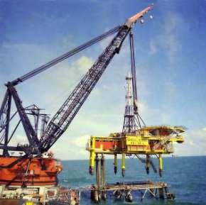


5 Life of Field (LoF) Upstream Activities Acquisition Abandonment Exploration Production Development

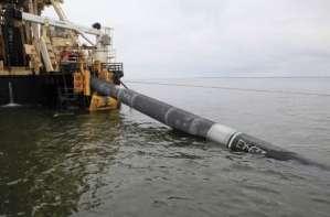
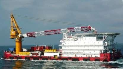


6 Geospatial Data Seismic Well Pipeline Platform Production
7 Challenges of Standardisations Different vintages from several vendors Multiple discipline data types dependences with data source activities Data formats, Native data data identify in locally format and not in universal format Metadata data about data Unknown data quality completeness and integrity
8 Standardisations Definition The process of establishing and applying standards. Standardisation is defined by the International Organisation for Standardisation (ISO) as the process of formulating and applying rules for an orderly approach to a specific activity for the benefit and with the cooperation of all concerned, and in particular for the promotion of optimum overall economy, taking due account of functional conditions and safety requirements. Article from International Organization for Standardization (ISO)
9 Accredited Bodies in Geospatial Industry IMCA The International Marine Contractors Association IOGP International Association of Oil & Gas Producers SIRIM Standards and Industrial Research Institute of Malaysia ISO International organization for Standardization PPDM The Professional Petroleum Data Management Association OGC Geospatial Consortium GSDI Global Spatial Data Infrastructure Association FGDC Federal Geographic data Committee UN-GGIM Unite Nations Committee of Expert on Global Geospatial Information Management MyGDI Malaysian Geospatial Data Infrastructure
10 Approach of Geospatial Data Standard Identify requirements or organisation needs Check with industry practices Develop business workflows Implement the standard Update requirements Organisations Needs Industry Standard Business Workflows Standard Implementation Standardisations Update
11 Criteria on Standardisations Defining main elements in Geospatial Data Standards Connection data link How will two systems physically connected? Encoding data format What format will be used to represent the data elements? Structure data model mapping What entities will be allowed, what attributes will be mandatory? Enumerations - reference value Which attributes have limitations or potential values? Conventions business rules There are always inherent usually undocumented relationship between two elements Control house keeping One essential element that is often neglected is that of controlling the process Article from The Management of Oil Industry Exploration & Production Data by Steve Hawtin

12 PETRONAS Standard and References PPGUA PETRONAS Procedures and Guideline for Upstream Activities PTS PETRONAS Technical Standard Technical Data Frameworks Technical Data Guideline & Workflow

13 IMPROVING PERFORMANCE Outcome of Standardisations TRUSTED DATA ON DEMAND Data Availability Centralised Consistent Complete & Standardised Data Quality Accuracy and Integrity Data Accessibility & Collaboration Integrated Seamless and Informed Decision Data Analytics & Virtualisation Interactive Predictive INCREASING VALUE
14 Conclusion Reduce cost in term of man-hours to manage data Data available and readiness for the business Generate high value on data quality Provide trusted data to users Accelerate process on data update and easy access Simplify process and easy to understand by users Seamless data interoperability with others repository & database

15 Thank you
MALAYSIAN STANDARD INFORMATION AND DOCUMENTATION - RECORDS MANAGEMENT - PART 1: GENERAL (ISO :2001, IDT)
") MALAYSIAN STANDARD MS 2223-1:2009 INFORMATION AND DOCUMENTATION - RECORDS MANAGEMENT - PART 1: GENERAL (ISO 15489-1:2001, IDT) ICS: 01.140.20 Descriptors: information, documentation, record management,
MALAYSIAN STANDARD MS 2223-1:2009 INFORMATION AND DOCUMENTATION - RECORDS MANAGEMENT - PART 1: GENERAL (ISO 15489-1:2001, IDT) ICS: 01.140.20 Descriptors: information, documentation, record management,
E&P Data Management Challenges
 E&P Data Management Challenges Doing more with subsurface data Daljit Singh Sukhdev Singh Senior Manager, Petroleum Engineering Data, Technical Data, Malaysia Petroleum Management(MPM), PETRONAS 13 October
CLICK HERE TO KNOW MORE
 CLICK HERE TO KNOW MORE UNDERGROUND UTILITY MAPPING IN MALAYSIA MOVING BEYOND 2020 Mohd Yunus Mohd Yusoff, PhD Department of Survey and Mapping Malaysia mohd.yunus@jupem.gov.my Geo Smart 2015, Kuala Lumpur,
PETRONAS E&P Technical Data Quality Metrics Initiative Going Green with Data
 PETRONAS E&P Technical Data Quality s Initiative Going Green with Data Hassan B Sabirin Regulatory Compliance & Technical Assurance, Technical Data Petroleum Management Unit (PMU) PETRONAS E&P Digital
Initial Operating Capability & The INSPIRE Community Geoportal
 INSPIRE Conference, Rotterdam, 15 19 June 2009 1 Infrastructure for Spatial Information in the European Community Initial Operating Capability & The INSPIRE Community Geoportal EC INSPIRE GEOPORTAL TEAM
Certified Petroleum Data Analyst (CPDA) Certification Update
 Certification Update") PROFESSIONAL PETROLEUM DATA MANAGEMENT ASSOCIATION Certified Petroleum Data (CPDA) Certification Update Sharon Barnes, PDMCC Member Ingrid Kristel, Project Manager, PPDM 1 3/17/2015 WHO IS THE PDMCC? Data
PROFESSIONAL PETROLEUM DATA MANAGEMENT ASSOCIATION Certified Petroleum Data (CPDA) Certification Update Sharon Barnes, PDMCC Member Ingrid Kristel, Project Manager, PPDM 1 3/17/2015 WHO IS THE PDMCC? Data
Institute of Materials, Malaysia
 Institute of Materials, Malaysia M. Azmi M. Noor FIMM, AFiCHEME MIQA Forum, KGNS 17 th Mar, 2016 Content Preamble & Background of Welding Industry Welding Challenges in O&G industry Business Case for CWCS
Data Partnerships to Improve Health Frequently Asked Questions. Glossary...9
 FAQ s Data Partnerships to Improve Health Frequently Asked Questions BENEFITS OF PARTICIPATING... 1 USING THE NETWORK.... 2 SECURING THE DATA AND NETWORK.... 3 PROTECTING PRIVACY.... 4 CREATING METADATA...
Philip J. Meis, M.S., P.E., M.ASCE Chair
 Establishing ASCE Standard Consensus Activity for Utility As-Built Records Philip J. Meis, M.S., P.E., M.ASCE Chair Utility As-Built Standard Overview Background and Need Scope Committee Members Schedule
Geospatial Intelligence Interoperability Through Standards Gordon C.Ferrari Chief, Content Standards and Interoperability Division
 Geospatial Intelligence Interoperability Through Standards Gordon C.Ferrari Chief, Content Standards and Interoperability Division 15 May 2002 NIMA Vision and Mission Statements National Imagery and Mapping
DEVELOPING, ENABLING, AND SUPPORTING DATA AND REPOSITORY CERTIFICATION
 DEVELOPING, ENABLING, AND SUPPORTING DATA AND REPOSITORY CERTIFICATION Plato Smith, Ph.D., Data Management Librarian DataONE Member Node Special Topics Discussion June 8, 2017, 2pm - 2:30 pm ASSESSING
eresearch Collaboration across the Pacific:
 eresearch Collaboration across the Pacific: Marine Systems and Australian Marine Science Craig Johnson University of Tasmania Outline Introduce the Australian Ocean Network Possibilities for trans-pacific
CERTIFIED PETROLEUM DATA ANALYST (CPDA) INFORMATION SESSION
 INFORMATION SESSION") CERTIFIED PETROLEUM DATA ANALYST (CPDA) INFORMATION SESSION ALEX ROSS, CPDA SRA INFORMATION TECHNOLOGY INGRID KRISTEL PROFESSIONAL PETROLEUM DATA MANAGEMENT (PPDM) ASSOCIATION March 27 th, 2018 1 AGENDA
CERTIFIED PETROLEUM DATA ANALYST (CPDA) INFORMATION SESSION ALEX ROSS, CPDA SRA INFORMATION TECHNOLOGY INGRID KRISTEL PROFESSIONAL PETROLEUM DATA MANAGEMENT (PPDM) ASSOCIATION March 27 th, 2018 1 AGENDA
GeoDCAT-AP Representing geographic metadata by using the "DCAT application profile for data portals in Europe"
 GeoDCAT-AP Representing geographic metadata by using the "DCAT application profile for data portals in Europe" Andrea Perego, Vlado Cetl, Anders Friis-Christensen, Michael Lutz, Lorena Hernandez Joint
Discovery and Access of Geospatial Resources Using GIS Portal Toolkit Marten Hogeweg Product Manager GIS Portal Toolkit
 Discovery and Access of Geospatial Resources Using GIS Portal Toolkit Marten Hogeweg Product Manager GIS Portal Toolkit Outline Elements of Spatial Data Infrastructures Current trends Position of GIS portals
Geospatial Enterprise Search. June
 Geospatial Enterprise Search June 2013 www.voyagersearch.com www.voyagersearch.com/demo The Problem: Data Not Found The National Geospatial-Intelligence Agency is the primary source of geospatial intelligence
The PICES Metadata Federation: Pacific-wide marine metadata discovery, management and delivery for FUTURE
 PICES 17th Annual Meeting Dalian, People s Republic of China October 30, 2008 The PICES Metadata Federation: Pacific-wide marine metadata discovery, management and delivery for FUTURE S. Allen Macklin
Homeland Security and Geographic Information Systems
 Page 1 of 5 Homeland Security and Geographic Information Systems How GIS and mapping technology can save lives and protect property in post-september 11th America Introduction Timely, accurate information,
CURSO Inspire INSPIRE. Ponente: Pablo Echamendi Lorente. MERCREDI 22/ Wednesday 22 nd W S III : M A K I N G D A T A D I S C O V E R A B L E
 CURSO Inspire MERCREDI 22/ Wednesday 22 nd Ponente: Pablo Echamendi Lorente WS 2 SCHEDULE INTRODUCTION CATALOGUES: OBJECTIVES ORGANISATION DISTRIBUTION ROLES REVISION INTRODUCTION + Information = + difficult
Singapore. Mr Soh Kheng Peng. Singapore Land Authority
 Country Report 2006 (Based on the PCGIAP-Data Integration Template 2006) Singapore Country/state: Name of contact person: Affiliation, Organization: Function, Position: Address: Email address: Tel, Fax
Standards, standardisation & INSPIRE Status, issues, opportunities
 Standards, standardisation & INSPIRE Status, issues, opportunities INSPIRE Coordination Team 6 th MIG meeting, 13-14 June 2017 Joint Research Centre The European Commission's science and knowledge service
Metadata or "data about data" describe the content, quality, condition, and other characteristics of data. The Federal Geographic Data Committee
 Metadata or "data about data" describe the content, quality, condition, and other characteristics of data. The Federal Geographic Data Committee (http://www.fgdc.gov/) approved the Content Standard for
INSPIRE WS2 METADATA: Describing GeoSpatial Data
 WS2 METADATA: Describing GeoSpatial Data Susana Fontano Planning General concepts about metadata The use of standards Items about the creation of metadata Software How to create metadata The ISO19115 Standard
INSPIRE: The ESRI Vision. Tina Hahn, GIS Consultant, ESRI(UK) Miguel Paredes, GIS Consultant, ESRI(UK)
 Miguel Paredes, GIS Consultant, ESRI(UK)") INSPIRE: The ESRI Vision Tina Hahn, GIS Consultant, ESRI(UK) Miguel Paredes, GIS Consultant, ESRI(UK) Overview Who are we? Introduction to ESRI Inc. and ESRI(UK) Presenters ArcGIS The ESRI Solution to
INSPIRE: The ESRI Vision Tina Hahn, GIS Consultant, ESRI(UK) Miguel Paredes, GIS Consultant, ESRI(UK) Overview Who are we? Introduction to ESRI Inc. and ESRI(UK) Presenters ArcGIS The ESRI Solution to
Enterprise Geographic Information Servers. Dr David Maguire Director of Products Kevin Daugherty ESRI
 Enterprise Geographic Information Servers Dr David Maguire Director of Products Kevin Daugherty ESRI Outline Introduction Enterprise GIS vs. Spatially-enabled IS Architectures for building Enterprise GIS
Geospatial Multistate Archive and Preservation Partnership Metadata Comparison
 Geospatial Multistate Archive and Preservation Partnership Metadata Comparison Cindy Clark, Utah s Automated Geographic Reference Center Glen McAninch, Kentucky Dept. for Libraries and Archives Steve Morris,
The EP Technical Data Quality Metrics Initiative
 The EP Technical Data Quality Metrics Initiative Architectural Considerations for Global Governance Philip Lesslar, Technical Assurance, Technical Data Digital Energy Conference 13 th October 2014 Impiana
A Metadata Standard for IGI&S: Spatial Data Standards for Facilities, Infrastructure, and Environment - Metadata (SDSFIE-M)
") A Metadata Standard for IGI&S: Spatial Data Standards for Facilities, Infrastructure, and Environment - Metadata (SDSFIE-M) Mr. David LaBranche, PE DISDI Program Manager ODUSD(I&E) July 15, 2014 ESRI IUC
A Metadata Standard for IGI&S: Spatial Data Standards for Facilities, Infrastructure, and Environment - Metadata (SDSFIE-M) Mr. David LaBranche, PE DISDI Program Manager ODUSD(I&E) July 15, 2014 ESRI IUC
PROMOTION OF HIGHER EFFICIENCY ROOM AIR CONDITIONERS IN THAILAND: NATIONAL POLICY ROADMAP. Endorsed by
 PROMOTION OF HIGHER EFFICIENCY ROOM AIR CONDITIONERS IN THAILAND: NATIONAL POLICY ROADMAP Endorsed by JUNE 2016 This report has been produced as part of the ASEAN-SHINE program. ASEAN-SHINE is an initiative
Effective Data Engineering for Data Science (Analytics)
") Effective Data Engineering for Data Science (Analytics) Prashanth H Southekal, PhD Managing Principal DBP-Institute www.dbp-institute.com Data for Business Performance (DBP) 1 Before We Start Data for
Effective Data Engineering for Data Science (Analytics) Prashanth H Southekal, PhD Managing Principal DBP-Institute www.dbp-institute.com Data for Business Performance (DBP) 1 Before We Start Data for
Report of the Working Group on Toponymic Data Files and Gazetteers
 UNITED NATIONS WORKING PAPER GROUP OF EXPERTS NO. 37 ON GEOGRAPHICAL NAMES Twenty-sixth session Vienna, 2-6 May 2011 Item 9 of the Provisional Agenda Activities relating to the Working Group on Toponymic
INSPIRE & Environment Data in the EU
 INSPIRE & Environment Data in the EU Andrea Perego Research Data infrastructures for Environmental related Societal Challenges Workshop @ pre-rda P6 Workshops, Paris 22 September 2015 INSPIRE in a nutshell
Research on Geo-information Data Model for Preselected Areas of Geological Disposal of Highlevel Radioactive Waste
 IOP Conference Series: Earth and Environmental Science PAPER OPEN ACCESS Research on Geo-information Data Model for Preselected Areas of Geological Disposal of Highlevel Radioactive Waste To cite this
International Oceanographic Data and Information Exchange - Ocean Data Portal (IODE ODP)
") International Oceanographic Data and Information Exchange - Ocean Data Portal (IODE ODP) Enabling science through seamless and open access to marine data Credits This presentation was developed by: Mr.
International Oceanographic Data and Information Exchange - Ocean Data Portal (IODE ODP) Enabling science through seamless and open access to marine data Credits This presentation was developed by: Mr.
Reducing Consumer Uncertainty
 Spatial Analytics Reducing Consumer Uncertainty Towards an Ontology for Geospatial User-centric Metadata Introduction Cooperative Research Centre for Spatial Information (CRCSI) in Australia Communicate
Infrastructure for Spatial Information in Europe. Proposed action for update of MIWP: Alternative encodings for INSPIRE data
 INSPIRE Infrastructure for Spatial Information in Europe Proposed action for update of MIWP: Alternative encodings for INSPIRE data Type Creator MIWP Action fiche DG ENV Date/status/version 20/11/2017
ADVANCED GEOGRAPHIC INFORMATION SYSTEMS Vol. II - Geospatial Interoperability : The OGC Perspective Open Geospatial Consortium, Inc.
 GEOSPATIAL INTEROPERABILITY: THE OGC PERSPECTIVE Open Open Geospatial Consortium, Wayland, MA, USA Keywords: geographic information systems, geospatial services, interoperability, interface specification,
Basic Principles of MedWIS - WISE interoperability
 Co-ordination committee seminar of the national focal points Basic Principles of MedWIS - WISE interoperability Eduardo García ADASA Sistemas Nice - France Agenda WISE vs MedWIS WISE WISE DS WISE vs WISE
Oracle Spatial Users Conference
 April 27, 2006 Tampa Convention Center Tampa, Florida, USA Stephen Smith GIS Solutions Manager Large Image Archive Management Solutions Using Oracle 10g Spatial & IONIC RedSpider Image Archive Outline
National Data Sharing and Accessibility Policy-2012 (NDSAP-2012)
") National Data Sharing and Accessibility Policy-2012 (NDSAP-2012) Department of Science & Technology Ministry of science & Technology Government of India Government of India Ministry of Science & Technology
National Data Sharing and Accessibility Policy-2012 (NDSAP-2012) Department of Science & Technology Ministry of science & Technology Government of India Government of India Ministry of Science & Technology
Geospatial Information at the United Nations UNITED NATIONS. Geospatial Information Section
 Geospatial Information at the United Nations UNITED NATIONS Geospatial Information Section United Nations Secretariat Official and Thematic Cartography Guidelines & Clearance for Maps Administrative Instruction,
Transformative characteristics and research agenda for the SDI-SKI step change: A Cadastral Case Study
 Transformative characteristics and research agenda for the SDI-SKI step change: A Cadastral Case Study Dr Lesley Arnold Research Fellow, Curtin University, CRCSI Director Geospatial Frameworks World Bank
Presented by Kit Na Goh
 Developing A Geo-Spatial Search Tool Using A Relational Database Implementation of the FGDC CSDGM Model Presented by Kit Na Goh Introduction Executive Order 12906 was issued on April 13, 1994 with the
CHARTER OUR MISSION OUR OBJECTIVES OUR GUIDING PRINCIPLES
 OUR MISSION Promote the highest level of safety for the U.S. offshore oil and natural gas industry through effective leadership, communication, teamwork, utilization of disciplined management systems and
Opportunities and Obstacles for Enabling the Use of Geospatial Applications
 Session 2B: Geospatial Knowledge Platforms: Empowering the SDGs through geographic tools and services Opportunities and Obstacles for Enabling the Use of Geospatial Applications Krystal Wilson Secure World
ISO INTERNATIONAL STANDARD. Geographic information Filter encoding. Information géographique Codage de filtres. First edition
 INTERNATIONAL STANDARD ISO 19143 First edition 2010-10-15 Geographic information Filter encoding Information géographique Codage de filtres Reference number ISO 19143:2010(E) ISO 2010 PDF disclaimer This
Records Management and Interoperability Initiatives and Experiences in the EU and Estonia
 Records Management and Interoperability Initiatives and Experiences in the EU and Estonia September 18, 2012 Liivi Karpištšenko Ministry of Economic Affairs and Communication Kuldar Aas National Archives
SEMANTIC SOLUTIONS FOR OIL & GAS: ROLES AND RESPONSIBILITIES
 SEMANTIC SOLUTIONS FOR OIL & GAS: ROLES AND RESPONSIBILITIES Jeremy Carroll, Ralph Hodgson, {jeremy,ralph}@topquadrant.com This paper is submitted to The W3C Workshop on Semantic Web in Energy Industries
LEGISLATIVE SITUATION IN MALAYSIA
 ATTACHMENT 13 LEGISLATIVE SITUATION IN MALAYSIA Pirunthavany Muthuvelu Ministry of Health Malaysia (MOH) Engineering Services Division BACKGROUND There were public concerns over the health effects of base
MANAGING STATISTICAL DEVELOPMENT AND INFORMATION TECHNOLOGY IN THE STATISTICAL SYSTEM OF MALAYSIA
 SIXTH MANAGEMENT SEMINAR FOR HEADS OF NATIONAL STATISTICAL OFFICES IN ASIA AND THE PACIFIC. 28 30 MAY 2007, HONG KONG, CHINA 1. Introduction MANAGING STATISTICAL DEVELOPMENT AND INFORMATION TECHNOLOGY
This document is a preview generated by EVS
 INTERNATIONAL STANDARD ISO 19153 First edition 2014-02-15 Geospatial Digital Rights Management Reference Model (GeoDRM RM) Modèle de référence pour la gestion numérique des droits d utilisation de l information
SDI and the Key Elements
 SDI and the Key Elements Roger Longhorn Information Policy Advisor, The Coastal & Marine Union (EUCC) Senior Information Policy Analyst & Principal SDI Expert, Compass Informatics Ltd (Ireland) (www.compass.ie)
Enterprise GRC Implementation
 Enterprise GRC Implementation Our journey so far implementation observations and learning points Derek Walker Corporate Risk Manager National Grid 1 Introduction to National Grid One of the world s largest
NIS Standardisation ENISA view
 NIS Standardisation ENISA view Dr. Steve Purser Brussels, 19 th September 2017 European Union Agency for Network and Information Security Instruments For Improving Cybersecurity Policy makers have a number
Earth Science Community view on Digital Repositories
 Ground European Network for Earth Science Interoperations Digital Repository Dissemination and Exploitation of GRids in Earth science Earth Science Community view on Digital Repositories Luigi FUSCO -
This document is a preview generated by EVS
 TECHNICAL SPECIFICATION ISO/TS 19163-1 First edition 2016-01-15 Geographic information Content components and encoding rules for imagery and gridded data Part 1: Content model Information géographique
Consolidation Team INSPIRE Annex I data specifications testing Call for Participation
 INSPIRE Infrastructure for Spatial Information in Europe Technical documents Consolidation Team INSPIRE Annex I data specifications testing Call for Participation Title INSPIRE Annex I data specifications
Information Management Fundamentals by Dave Wells
 Information Management Fundamentals by Dave Wells All rights reserved. Reproduction in whole or part prohibited except by written permission. Product and company names mentioned herein may be trademarks
This document is a preview generated by EVS
 INTERNATIONAL STANDARD ISO 19119 Second edition 2016-01-15 Geographic information Services Information géographique Services Reference number ISO 19119:2016(E) ISO 2016 ISO 19119:2016(E) COPYRIGHT PROTECTED
The European Commission s science and knowledge service. Joint Research Centre
 The European Commission s science and knowledge service Joint Research Centre GeoDCAT-AP The story so far Andrea Perego, Antonio Rotundo, Lieven Raes GeoDCAT-AP Webinar 6 June 2018 What is GeoDCAT-AP Geospatial
Step 1: Open browser to navigate to the data science challenge home page
 Step 1: Open browser to navigate to the data science challenge home page https://datascience.ey.com/ Step 2: Logging in You will need to create an account if you are a new user. Click the sign up button
Intelligent transport systems Cooperative systems Definition of a global concept for Local Dynamic Maps
 Provläsningsexemplar / Preview TECHNICAL SPECIFICATION ISO/TS 18750 First edition 2015-05-15 Intelligent transport systems Cooperative systems Definition of a global concept for Local Dynamic Maps Systèmes
Striving for efficiency
 Ron Dekker Director CESSDA Striving for efficiency Realise the social data part of EOSC How to Get the Maximum from Research Data Prerequisites and Outcomes University of Tartu, 29 May 2018 Trends 1.Growing
The Value of Metadata
 The Value of Metadata Why is metadata important to your agency / organization? Metadata has tremendous value to Individuals within your organization, as well as to individuals outside of your organization
Trust and Certification: the case for Trustworthy Digital Repositories. RDA Europe webinar, 14 February 2017 Ingrid Dillo, DANS, The Netherlands
 Trust and Certification: the case for Trustworthy Digital Repositories RDA Europe webinar, 14 February 2017 Ingrid Dillo, DANS, The Netherlands Perhaps the biggest challenge in sharing data is trust: how
Cognizant Cloud Security Solution
 CLOUD SECURITY OVERVIEW Cognizant Cloud Security Solution Transform your security operation to protect your business across public and hybrid cloud environments. December 2017 The advantages of moving
Bruce Wright, John Ward, Malcolm Field, Met Office, United Kingdom
 The Met Office s Logical Store Bruce Wright, John Ward, Malcolm Field, Met Office, United Kingdom Background are the lifeblood of the Met Office. However, over time, the organic, un-governed growth of
Land Administration and Management: Big Data, Fast Data, Semantics, Graph Databases, Security, Collaboration, Open Source, Shareable Information
 Land Administration and Management: Big Data, Fast Data, Semantics, Graph Databases, Security, Collaboration, Open Source, Shareable Information Platform Steven Hagan, Vice President, Engineering 1 Copyright
Report from UN-GGIM: Europe A year in review
 Report from UN-GGIM: Europe A year in review Carol Agius UN-GGIM: Europe Joint UN-GGIM: Europe ESS meeting on the Integration of Statistical and Geospatial Information March 2017 The aim of UN-GGIM: Europe
The Development of Location Based Services in Malaysia
 Page 1 of 8 GISdevelopment.net ---> Technology ---> Location Based Service Print The Development of Location Based Services in Malaysia Ahmad Haris Abdul Halim Department of Information Science Faculty
Detailed analysis + Integration plan
 Outline Integration methodology Detailed analysis + Integration plan Conclusions 2 Outline Integration methodology Detailed analysis + Integration plan Conclusions 3 EULF-ISA Integration: methodology Phase
United Nations Spatial Data Infrastructure (UNSDI)
") United Nations Spatial Data Infrastructure (UNSDI) & UN Geographic Information Working Group (UNGIWG) T. Suha ÜLGEN Senior Advisor on Spatial Data Infrastructure Office of the Assistant Secretary-General
United Nations Spatial Data Infrastructure (UNSDI) & UN Geographic Information Working Group (UNGIWG) T. Suha ÜLGEN Senior Advisor on Spatial Data Infrastructure Office of the Assistant Secretary-General
This course provides introductory knowledge of the land survey systems used in the United States - Congressional/Jeffersonian, Metes and Bounds,
 PDM-001 Introduction to High quality, trusted and accessible data and information is essential to the oil and gas industry. As the professional society for data managers, the plays a key role in meeting
REPORT OF THE WORKING GROUP 2: REGIONAL FUNDAMENTAL DATA
 UNITED NATIONS E/CONF.97/3/Add.2 ECONOMIC AND SOCIAL COUNCIL Seventeenth United Nations Regional Cartographic Conference for Asia and the Pacific Bangkok, 18-22 September 2006 Item 5 of the provisional
GEO-SPATIAL METADATA SERVICES ISRO S INITIATIVE
 GEO-SPATIAL METADATA SERVICES ISRO S INITIATIVE Pushpalata B Shah, Navita J Thakkar Space Applications Centre (ISRO) Ahmedabad 380 015 - pushpa@sac.isro.gov.in Commission IV, Working Group IV/5 KEYWORDS:
PRODUCT BROCHURE ERDAS APOLLO MANAGING AND SERVING GEOSPATIAL INFORMATION
 PRODUCT BROCHURE ERDAS APOLLO MANAGING AND SERVING GEOSPATIAL INFORMATION ERDAS APOLLO Do you have large volumes of geospatial information, regularly updated data stores, and a distributed user base? Do
A FUTURE FOR A COMMON BIO-LOGGING LANGUAGE?
 6th International Bio-logging Symposium 27 September 2017 Konstanz, Germany A FUTURE FOR A COMMON BIO-LOGGING LANGUAGE? DISCUSSIONS ABOUT DATA STANDARDS AND INTEROPERABILITY IN THE BIO-LOGGING WORLD Francesca
Transformative characteristics and research agenda for the SDI-SKI step change:
 Transformative characteristics and research agenda for the SDI-SKI step change: A Cadastral Case Study Dr Lesley Arnold Research Fellow, Curtin University, CRCSI Director Geospatial Frameworks World Bank
Harmonisation of distributed geographic datasets - A model driven approach for geotechnical & footprint data.
 Harmonisation of distributed geographic datasets - A model driven approach for geotechnical & footprint data. Bart van den Berg (1,2), Bart Hulshof (1), Theo Tijssen (2) en Peter van Oosterom (2) (1) Shell/NAM,
AN UPDATE ON MALAYSIAN STANDARDS ON HALAL
 AN UPDATE ON MALAYSIAN STANDARDS ON HALAL RIDZWAN KASIM Senior Director (Standardisation) Department of Standards Malaysia Ministry of Science, Technology and Innovation ridzwan@jsm.gov.my +603-83182225
ebooks Preservation at Scholars Portal Kate Davis & Grant Hurley Scholars Portal, Ontario Council of University Libraries
 ebooks Preservation at Scholars Portal Kate Davis & Grant Hurley Scholars Portal, Ontario Council of University Libraries The Charlotte Initiative Open Conference March 10, 2017 Outline OCUL and Scholars
Address Register of the Agency for Real Estate Cadastre
 Description of the software solution: Address Register of the Agency for Real Estate Cadastre Detail description of the solution and the technical implementation Agency for Real Estate Cadastre (AREC)
Introduction to INSPIRE. Network Services
 Introduction to INSPIRE. Network Services European Commission Joint Research Centre Institute for Environment and Sustainability Digital Earth and Reference Data Unit www.jrc.ec.europa.eu Serving society
Quality Management Systems (ISO 9001:2015 and ISO 29001) Lead Auditor training (EY/IMSA Q03)
 Lead Auditor training (EY/IMSA Q03)") Quality Management Systems (ISO 9001:2015 and ISO 29001) Lead Auditor training (EY/IMSA Q03) Doha, 4 8 March 2018 IMSA is an IRCA/CQI Approved Training Provider Contents Section 1: About the program 04
Quality Management Systems (ISO 9001:2015 and ISO 29001) Lead Auditor training (EY/IMSA Q03) Doha, 4 8 March 2018 IMSA is an IRCA/CQI Approved Training Provider Contents Section 1: About the program 04
Bridging Continents. Kazu Yamaji National Institute of Informatics JAPAN
 Bridging Continents Kazu Yamaji National Institute of Informatics JAPAN 2015-04-13 NII-funded Programs NII-IRP (Institutional Repositories Program) http://www.nii.ac.jp/irp/en/ Phase 1 : FY2005-2007 Phase
Oil, Gas & Energy Sector OBNI Industry Report in Malaysia
 Oil, Gas & Energy Sector 2017 OBNI Industry Report in Malaysia This report serves as a preliminary introduction that highlights key features and factors relevant to the Oil, Gas & Energy sector in Malaysia.
GEOSPATIAL ENGINEERING COMPETENCIES. Geographic Information Science
 GEOSPATIAL ENGINEERING COMPETENCIES Geographic Information Science The character and structure of spatial information, its methods of capture, organisation, classification, qualification, analysis, management,
ISO 2146 INTERNATIONAL STANDARD. Information and documentation Registry services for libraries and related organizations
 INTERNATIONAL STANDARD ISO 2146 Third edition 2010-04-15 Information and documentation Registry services for libraries and related organizations Information et documentation Services de registre pour les
An Overview of BuildingSMART. Christopher Groome Secretary buildingsmart International Moscow June 2016
 An Overview of BuildingSMART Christopher Groome Secretary buildingsmart International Moscow June 2016 buildingsmart today Values Open Neutral Not-for-profit International Goals Create open BIM standards
Next-Generation Standards Management with IHS Engineering Workbench
 ENGINEERING & PRODUCT DESIGN Next-Generation Standards Management with IHS Engineering Workbench The addition of standards management capabilities in IHS Engineering Workbench provides IHS Standards Expert
GOVERNMENT GAZETTE REPUBLIC OF NAMIBIA
 GOVERNMENT GAZETTE OF THE REPUBLIC OF NAMIBIA N$7.20 WINDHOEK - 7 October 2016 No. 6145 CONTENTS Page GENERAL NOTICE No. 406 Namibia Statistics Agency: Data quality standard for the purchase, capture,
Metadata at Statistics Canada. Canadian Metadata Forum September 19-20, 2003
 Metadata at Statistics Canada Canadian Metadata Forum September 19-20, 2003 1 Corporate metadata at Statistics Canada Integrated Metadatabase (IMDB) Collection of facts about each of Statistics Canada
OpenSpirit Enabled GIS Portal Apps. Todd Buehlman, LOGIC Solutions Group Clay Harter, TIBCO September 7, 2016
 OpenSpirit Enabled GIS Portal Apps Todd Buehlman, LOGIC Solutions Group Clay Harter, TIBCO September 7, 2016 LOGIC Solutions Group Working to create, manage and integrate your information management and
European Interoperability Reference Architecture (EIRA) overview
 overview") European Interoperability Reference Architecture (EIRA) overview Version 0.8.3 beta 09/01/2015 ISA Action 2.1: European Interoperability Architecture Specific Contract N. 54 Framework contract N. DI/07171
European Interoperability Reference Architecture (EIRA) overview Version 0.8.3 beta 09/01/2015 ISA Action 2.1: European Interoperability Architecture Specific Contract N. 54 Framework contract N. DI/07171
INSPIRE overview and possible applications for IED and E-PRTR e- Reporting Alexander Kotsev
 INSPIRE overview and possible applications for IED and E-PRTR e- Reporting Alexander Kotsev www.jrc.ec.europa.eu Serving society Stimulating innovation Supporting legislation The European data puzzle 24
Expressions of Interest
 Expressions of Interest Technology Solution for Web-based Aboriginal Heritage Information Management System CLOSING TIME AND DATE: 5:30pm AWST, Wednesday 9 December 2015 ISSUED BY: National Trust of Australia
Understanding and Using Metadata in ArcGIS. Adam Martin Marten Hogeweg Aleta Vienneau
 Understanding and Using Metadata in ArcGIS Adam Martin Marten Hogeweg Aleta Vienneau Adam Martin National Government Account Management R&D Open Data Marten Hogeweg National Government Professional Services
ISO/IEC Software Engineering Lifecycle profiles for Very Small Entities (VSEs) Part 2-1: Framework and taxonomy
 Part 2-1: Framework and taxonomy") INTERNATIONAL STANDARD ISO/IEC 29110-2-1 First edition 2015-11-01 Software Engineering Lifecycle profiles for Very Small Entities (VSEs) Part 2-1: Framework and taxonomy Ingénierie du logiciel Profil de
INTERNATIONAL STANDARD ISO/IEC 29110-2-1 First edition 2015-11-01 Software Engineering Lifecycle profiles for Very Small Entities (VSEs) Part 2-1: Framework and taxonomy Ingénierie du logiciel Profil de
In Accountable IoT We Trust
 In Accountable IoT We Trust AIOTI WG3 Security & Privacy-in-IoT Taskforces, and H2020 CSA CREATE-IoT & LSPs AG Trust in IoT Arthur van der Wees Managing Director Arthur s Legal, the global tech-by-design