The What, Why, Who and How of Where: Building a Portal for Geospatial Data. Alan Darnell Director, Scholars Portal
|
|
|
- Jewel Gray
- 5 years ago
- Views:
Transcription


1 The What, Why, Who and How of Where: Building a Portal for Geospatial Data Alan Darnell Director, Scholars Portal
2 What?

3 Scholars GeoPortal Beta release Fall 2011 Production release March 2012 OLITA Award for Technical Excellence

4 Search and Browse for Data Layers
5

6 Preview data

7 Zoom through 15 levels of cached tiles

8 Select different base maps

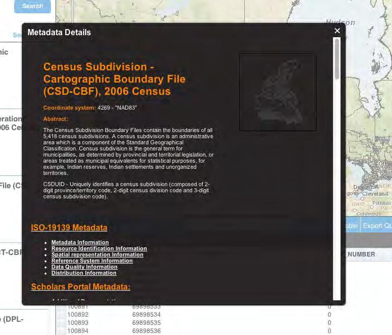
9 View Legend for each Layer

10 Refine searches by facets View abstract or full metadata record

11 View attributes of features in each layer
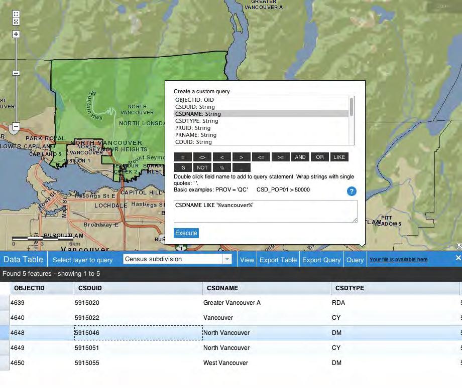
12 Query Attributes

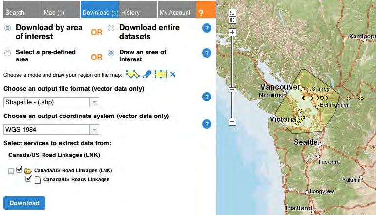
13 Download by pre-defined area or user-defined area Choose output file format Choose coordinate system
14

15 Create simple annotations

16 Print or save map as PDF
17 Content 80 TB of datasets include vector files and imagery large scale (city, region) and small scale (provincial, national) key providers: DMTI Spatial (DMTI Spatial SMART Consortium) Statistics Canada Ontario Geospatial Data Exchange (program of the Ontario Ministry of Natural Resources)
18 Why?
19 A Portal for Geospatial Data situation in 2007 large shared collections of GIS data access to these files varied from school to school much time spent on handling files, distributing them access for scholars limited to open hours discovery was difficult; retrieval was time consuming
20 Why a consortial approach? Addressing the problem was beyond the means of most individual libraries (financially, technically, staff skills) Pockets of specialized skills existed across the libraries but no one had all the necessary skills A track record of successful project management and application development with Scholars Portal A funding opportunity
21 Who?


22 420,00 FTE


23 Project Partners OCUL Governance Teams OCUL Executive Ontario Buys Scholars Portal
24 Project Management Group Ongoing coordination of working group activities Financial oversight Coordination of RFP, Usability Study, data license negotiations, External Advisory Committee Communications with stakeholders including OCUL libraries, Province, and the broader library community
25 Technical, Standards & Collections Working Group Metadata Best Practices Document Metadata Editing Toolkit Model Data License Functional Requirements (for RFP) Data Loading Priority List Ongoing testing and portal feedback Collections Policy
26 Teaching & Learning Working Group Teaching & Learning Strategy Document GeoPortal Help Guide OCUL Training session, Dec 2011 Getting Started Handout Survey of community regarding need for specific learning modules Ongoing portal testing and feedback

27
28 Scholars Portal Operations Team Responsible for project management, software development, and systems support Project Manager (Data and GIS Librarian) Development Team 4 programmers GIS Analyst Metadata Librarian Web Designer
29 How?
30 Developing the Plan 2007 OCUL map librarians consulted with researchers at various campuses and prepared needs assessment 2008 OCUL prepared a funding proposal to the province for a 3- year project to establish shared platform platform would support preview, multiple data layers, subsetting, extraction monitor results and benefits for researchers, students, and libraries 2009 received funding for $1.2M for a three year project
31 Users and Uses Content selection driven by analysis of users and uses Research survey issued in Fall 2011 to identify key research interests 59 completed responses breakdown by discipline research interests
32 Survey Results: Research Interests 98% of our sample was currently conducting a research project Reported Research Topics: Categorized
33 Survey Results: Use of Geospatial Data Percentage of Researchers using Data by Type Research Teaching 0
34 Survey Results: Desired GeoPortal Features - Searching Percentage of Researchers Interested in GeoPortal Features Search by keyword Search by geographic selection Search by place name Search by topic Search by date Search by scale
35 Survey Results: Desired GeoPortal Features - Downloading Download by user-specified geographic area 75 Download by specific attributes Percentage of Researchers interested in GeoPortal features 59 Download entire dataset 53 Download many file formats 44 Download range of projections
36 Survey Results: Desired GeoPortal Features - Other Percentage of Researchers interested in GeoPortal features
37 Early Decisions: Open Source or ESRI Advantages of integrated software stack ArcGIS map services provide elements of both WMS and WFS OCG services easy way to publish geoprocessing services (e.g. clipping and downloading, re-projections, and multiple output formats) Effective caching for enhanced performance Control over symbology to provide better user experience Familiarity with ESRI products in academic market Difficulties of incorporating open source solutions in competitive RFP process
38 Early Decisions: FGDC or ISO International standard; option to create national profiles North American Profile released in 2009 (InterNational Committee for Information Technology Standards (INCITS) and Canadian General Standards Board Committee on Geomatics) Adopted by the Canadian federal and Ontario provincial governments Hierarchical structure creates packages of metadata that can be reused and combined Support for the documentation of new geospatial data topologies and technologies
39 Data Loading and Map Services Data is loaded into the geodatabase Map document is created from this data; symbology defined at different scales Map document is published as a map service All map services are cached to ensure acceptable performance Map services allow users to preview data at various scales, explore attributes, and select a geographic subset for downloading
40 Scholars GeoPortal Data In Production DMTI OGDE DLI Open Content Total In Development (produced, awaiting caching) DMTI OGDE DLI Open Content Total Services include: Point, line, and polygon data (vector data) Image services (raster data) Attribute tables Bilingual data (French and English)
41 Evaluation & Assessment Surveys of Geospatial Library Services Qualitative Background Survey (Feb 2010) Quantitative Statistics Tracking Surveys (6 semesters, ) Usability Study (March 2012) Usage Statistics (Beginning March 2012)


42 Survey Results: Tasks performed in the geospatial library Average number of hours spent per semester 24% 9% 15% Infrastructure Support Developing Materials / Presentations Delivering Materials / Presentations Aquiring / Licensing Geospatial Data 8% 5% 3% Web Page Creation/Maintenance Managing and Organizing Data Authoring and Editing Metadata 6% 11% Indexing and Contours 19% Handling Mediated Requests
43 Survey Results: Geospatial Library Instruction Hours spent per semester on Instruction (blue) and Instruction Hours devoted to Spatial Literacy concepts (red) Average number of students reached by library instruction per semester Large Medium Small Total students reached by library instruction per semester, expressed per thousand L M S 0 Large Medium Small
44 What s Next?
45 Sustainability Plan approved by OCUL Directors in Fall 2011 supports ongoing staffing at Scholars Portal to maintain and develop the GeoPortal Establishment of an Operations Group to provide ongoing input into future enhancements Establishment of task groups as needed, to address teaching & learning, collections, metadata, and other future directions
46 Ongoing Assessment Conduct follow-up librarians surveys (less frequently, over 2 year period) Conduct follow-up researcher survey (2013) Review and report on usage of the portal
47 Foundation for Innovation Sustainable funding Strong development team Engagement of librarians Connections with faculty and students Feature rich server software Infrastructure with room to grow 47 47
48 Data Visualization Exploring large data sets using visual metaphors Geographic Visualizations setting filters on attributes changing symbology to represent values adding time as a dimension real-time data feeds Numeric Data viewed geographically link data from ODESI to geographic regions support pre-defined and on the fly visualizations 48 48


49 Population density Visualizing attribute data - Language distribution and perceived health spatially


50 1. 3. Custom maps, symbology, and filtering 2. Visualizing attribute data spatially, on the fly Create indicators, indexes; to visualize statistics
51 Growing the service More shared data sources Local library data collections Partners from across the country
52 Questions?
Business Model for Global Platform for Big Data for Official Statistics in support of the 2030 Agenda for Sustainable Development
 Business Model for Global Platform for Big Data for Official Statistics in support of the 2030 Agenda for Sustainable Development Introduction This note sets out a business model for a Global Platform
DATA SHARING AND DISCOVERY WITH ARCGIS SERVER GEOPORTAL EXTENSION. Clive Reece, Ph.D. ESRI Geoportal/SDI Solutions Team
 DATA SHARING AND DISCOVERY WITH ARCGIS SERVER GEOPORTAL EXTENSION Clive Reece, Ph.D. ESRI Geoportal/SDI Solutions Team Geoportal Extension for ArcGIS Server Context within an Enterprise Spatial Data Infrastructure
CANARIE Mandate Renewal Proposal
 CANARIE Mandate Renewal Proposal Kathryn Anthonisen BCNET Conference April 23, 2018 Let s connect! @kanthonisen canarie.ca @canarie_inc canarie.ca @canarie_inc 2 Core Purpose Advancement of Canada s Knowledge
SPARC 2 Consultations January-February 2016
 SPARC 2 Consultations January-February 2016 1 Outline Introduction to Compute Canada SPARC 2 Consultation Context Capital Deployment Plan Services Plan Access and Allocation Policies (RAC, etc.) Discussion
Facilities Master Plan Toronto Public Library Board Consultation
 STAFF REPORT INFORMATION ONLY Facilities Master Plan Toronto Public Library Board Consultation Date: May 28, 2018 20. To: From: Toronto Public Library Board City Librarian SUMMARY The purpose of this report
Understanding and Using Metadata in ArcGIS. Adam Martin Marten Hogeweg Aleta Vienneau
 Understanding and Using Metadata in ArcGIS Adam Martin Marten Hogeweg Aleta Vienneau Adam Martin National Government Account Management R&D Open Data Marten Hogeweg National Government Professional Services
Data publication and discovery with Globus
 Data publication and discovery with Globus Questions and comments to outreach@globus.org The Globus data publication and discovery services make it easy for institutions and projects to establish collections,
Leveraging metadata standards in ArcGIS to support Interoperability. Aleta Vienneau and Marten Hogeweg
 Leveraging metadata standards in ArcGIS to support Interoperability Aleta Vienneau and Marten Hogeweg Leveraging metadata standards in ArcGIS to support Interoperability Overview of metadata standards
Introduction to INSPIRE. Network Services
 Introduction to INSPIRE. Network Services European Commission Joint Research Centre Institute for Environment and Sustainability Digital Earth and Reference Data Unit www.jrc.ec.europa.eu Serving society
COPPUL Digital Preservation Network: Update for ACCOLEDS. Corey Davis COPPUL DPN Manager
 COPPUL Digital Preservation Network: Update for ACCOLEDS Corey Davis COPPUL DPN Manager What is digital preservation? a formal endeavor to ensure that digital information of continuing value remains accessible
Tools for Handling Big Data and Compu5ng Demands. Humani5es and Social Science Scholars
 Tools for Handling Big Data and Compu5ng Demands Humani5es and Social Science Scholars Outline Overview of Compute Canada and WestGrid Focus on Humani5es and Social Sciences The Resource Alloca5on Compe55on
EPA Near-port Community Capacity Building: Tools and Technical Assistance for Collaborative Solutions
 EPA Near-port Community Capacity Building: Tools and Technical Assistance for Collaborative Solutions Sabrina Johnson, Project Lead EPA Office of Transportation & Air Quality presented at Southeast Diesel
New Mexico s RGIS Program: State Geospatial Data Clearinghouse
 New Mexico s RGIS Program: State Geospatial Data Clearinghouse Laura Gleasner Su Zhang November 10, 2016 New Mexico RGIS: The State Digital Geospatial Data Clearinghouse The Resource Geographic Information
What s New in Desktop 10.1
 What s New in Desktop 10.1 Damian Spangrud Esri Redlands Trip Down Memory Lane ArcGIS A Complete System for Geographic Information Cloud Web Online Mobile Enterprise Desktop Sharing Information sharing
INSPIRE: The ESRI Vision. Tina Hahn, GIS Consultant, ESRI(UK) Miguel Paredes, GIS Consultant, ESRI(UK)
 Miguel Paredes, GIS Consultant, ESRI(UK)") INSPIRE: The ESRI Vision Tina Hahn, GIS Consultant, ESRI(UK) Miguel Paredes, GIS Consultant, ESRI(UK) Overview Who are we? Introduction to ESRI Inc. and ESRI(UK) Presenters ArcGIS The ESRI Solution to
INSPIRE: The ESRI Vision Tina Hahn, GIS Consultant, ESRI(UK) Miguel Paredes, GIS Consultant, ESRI(UK) Overview Who are we? Introduction to ESRI Inc. and ESRI(UK) Presenters ArcGIS The ESRI Solution to
Business Plan For Archival Preservation of Geospatial Data Resources
 State of Utah Business Plan For Archival Preservation of Geospatial Data Resources Version1: December 30, 2008 Table of Contents 1. INTRODUCTION... 3 2. GOALS FOR THE PROGRAM... 4 3. PROGRAM BENEFITS...
ArcGIS Enterprise: An Introduction. David Thom Solution Engineer State Government
 ArcGIS Enterprise: An Introduction David Thom Solution Engineer State Government What is ArcGIS Enterprise? ArcGIS Enterprise is server software that allows you to use infrastructure you manage to implement
The EOIS-CaMS User Guide for New Staff
 The EOIS-CaMS User Guide for New Staff CAMBRIAN COLLEGE This Employment Ontario project, program or service is funded by the Ontario government. 2016 The EOIS-CaMS User Guide for New Staff Disclaimer:
Best Practices for Designing Effective Map Services
 FedGIS Conference February 24 25, 2016 Washington, DC Best Practices for Designing Effective Map Services James Tedrick, Esri Matt Sokol, MD Dept. of Information Technology Web Mapping & Service Types
Esri Geoportal Server
 Esri Geoportal Server Implementing a Spatial Data Infrastructure @martenhogeweg Esri Geoportal Server Extending ArcGIS to enable discovery and use of geospatial resources in heterogeneous environments
CHAIR AND MEMBERS CIVIC WORKS COMMITTEE MEETING ON NOVEMBER 29, 2016
 TO: FROM: SUBJECT: CHAIR AND MEMBERS CIVIC WORKS COMMITTEE MEETING ON NOVEMBER 29, 2016 KELLY SCHERR, P.ENG., MBA, FEC MANAGING DIRECTOR ENVIRONMENTAL & ENGINEERING SERVICES AND CITY ENGINEER SHIFT RAPID
MODULE 1 BASIC LIDAR TECHNIQUES
 MODULE SCENARIO One of the first tasks a geographic information systems (GIS) department using lidar data should perform is to check the quality of the data delivered by the data provider. The department
Managing Imagery and Raster Data using Mosaic Datasets
 Esri European User Conference October 15-17, 2012 Oslo, Norway Hosted by Esri Official Distributor Managing Imagery and Raster Data using Mosaic Datasets Peter Becker ArcGIS is a Comprehensive Imagery
Open data and analytics for a sustainable energy future. Version 0.2 January 23 rd, 2017
 Open data and analytics for a sustainable energy future Version 0.2 January 23 rd, 2017 Structure of user manual 1 About the platform and partners 2 Managing organizations 3 Uploading and managing datasets
Presented by Kit Na Goh
 Developing A Geo-Spatial Search Tool Using A Relational Database Implementation of the FGDC CSDGM Model Presented by Kit Na Goh Introduction Executive Order 12906 was issued on April 13, 1994 with the
Esri Support for Geospatial Standards
 APRIL 2017 ArcGIS Is Open and Interoperable Esri Support for Geospatial Standards Copyright 2017 Esri All rights reserved. Printed in the United States of America. The information contained in this document
College of Agricultural Sciences UNIT STRATEGIC PLANNING UPDATES MARCH 2, Information Technologies
 College of Agricultural Sciences UNIT STRATEGIC PLANNING UPDATES MARCH 2, 2009 Information Technologies UNIT STRATEGIC PLANNING UPDATES MARCH 2, 2009 Information Technologies Executive Summary Challenges
CITY COUNCIL AGENDA REPORT
 CITY COUNCIL AGENDA REPORT Subject: AUMA RESOLUTION BROADBAND INTERNET Recommendation(s) That the AUMA Broadband Resolution 2016, provided as Attachment 1 to the May 24, 2016 report entitled AUMA Resolution
2017 Resource Allocations Competition Results
 2017 Resource Allocations Competition Results Table of Contents Executive Summary...3 Computational Resources...5 CPU Allocations...5 GPU Allocations...6 Cloud Allocations...6 Storage Resources...6 Acceptance
INFORMATION TECHNOLOGY ONE-YEAR PLAN
 INFORMATION TECHNOLOGY ONE-YEAR PLAN 2016-2017 Information and Communications Technology One-year Plan 2016-2017 The purpose of this document is to identify the activities being undertaken this year by
Enterprise Geographic Information Servers. Dr David Maguire Director of Products Kevin Daugherty ESRI
 Enterprise Geographic Information Servers Dr David Maguire Director of Products Kevin Daugherty ESRI Outline Introduction Enterprise GIS vs. Spatially-enabled IS Architectures for building Enterprise GIS
GISCI GEOSPATIAL CORE TECHNICAL KNOWLEDGE EXAM CANDIDATE MANUAL AUGUST 2017
 GISCI GEOSPATIAL CORE TECHNICAL KNOWLEDGE EXAM CANDIDATE MANUAL AUGUST 2017 This document provides information about the GISCI Geospatial Core Technical Knowledge Exam, now a requirement for GISCI GISP
Infrastructure PA Stephen Lecce
 PA Stephen Lecce Ministry of Stephen Lecce, Parliamentary Assistant Meeting: Topics: Topics: PA Stephen Lecce, MPP Monday, August 20, 2018 9:15 am 9:45 am Shaw Centre, Room 107, Level 1 National Centre
Understanding and using Metadata across the ArcGIS Platform. Aleta Vienneau Marten Hogeweg
 Understanding and using Metadata across the ArcGIS Platform Aleta Vienneau Marten Hogeweg Understanding and using Metadata across the ArcGIS Platform Metadata fundamentals ArcGIS platform Road ahead Metadata
Course Information
 Course Information 2018-2020 Master of Information Systems: Management and Innovation Institutt for teknologi / Department of Technology Index Index... i 1... 1 1.1 Content... 1 1.2 Name... 1 1.3 Programme
Reducing Consumer Uncertainty Towards a Vocabulary for User-centric Geospatial Metadata
 Meeting Host Supporting Partner Meeting Sponsors Reducing Consumer Uncertainty Towards a Vocabulary for User-centric Geospatial Metadata 105th OGC Technical Committee Palmerston North, New Zealand Dr.
Reducing Consumer Uncertainty
 Spatial Analytics Reducing Consumer Uncertainty Towards an Ontology for Geospatial User-centric Metadata Introduction Cooperative Research Centre for Spatial Information (CRCSI) in Australia Communicate
Academic Program Review at Illinois State University PROGRAM REVIEW OVERVIEW
 Academic Program Review at Illinois State University PROGRAM REVIEW OVERVIEW For Research and Service Centers Submitting Self-Study Reports Fall 2017 INTRODUCTION Primary responsibility for maintaining
Converting census data into GIS data
 Converting census data into GIS data For those interested in analyzing Canadian demographics data, census data can be downloaded directly from ODESI or the Canadian Census Analyser. In order to use the
Planning for Your Professional GIS Development: Esri Technical. Renee Schreibman Regional Training Consultant
 Planning for Your Professional GIS Development: Esri Technical Certification Renee Schreibman Regional Training Consultant Session Overview Benefits of Training Budgeting/Purchasing Training Delivery Methods
ArcGIS in the Cloud. Andrew Sakowicz & Alec Walker
 ArcGIS in the Cloud Andrew Sakowicz & Alec Walker Key Takeaways How to Identify Organizational Strategy & Priorities Esri s Cloud Offerings A Broad Spectrum Successfully Executing Your Strategy The Cloud
Mississippi Public Schools 2015
 Mississippi Public Schools 2015 Shapefile and geodatabase Tags education, administrative, schools, public, K-12 Summary To add to the state data clearinghouse the Mississippi public schools point feature.
Training Workshop Developing Rich Web mapping Applications Tunis, May 2016
 Training Workshop Developing Rich Web mapping Applications Tunis, 10 12 May 2016 1 Introduction With the advance of web mapping services and web technology, creating and publishing high-performing, modern-looking
Security and Privacy Governance Program Guidelines
 Security and Privacy Governance Program Guidelines Effective Security and Privacy Programs start with attention to Governance. Governance refers to the roles and responsibilities that are established by
First Research. User s Guide
 First Research User s Guide Welcome to First Research. This user guide will show you everything you need to know to access and utilize the wealth of information available from First Research. The First
CREATING SMART TRANSPORT SERVICES BY FACILITATING THE RE-USE OF OPEN GIS DATA
 OPEN TRANSPORT NET TOMAS MILDORF 16 JUNE 2014 INSPIRE CONFERENCE 2014, AALBORG, DENMARK CREATING SMART TRANSPORT SERVICES BY FACILITATING THE RE-USE OF OPEN GIS DATA 2 1 OTN AT A GLANCE Full title OpenTransportNet
Implementing Web-Scale Discovery in an Academic Research Library
 Implementing Web-Scale Discovery in an Academic Research Library Usability Testing November 2008 Tammy Allgood, Web Services Librarian Evaluation of library web site home page July 2009 Tammy Allgood,
Educator Learning Journeys. Tracy Immel Global Director Teacher Professional Development Programs & Certification
 Educator Learning Journeys Tracy Immel timmel@microsoft.com Global Director Teacher Professional Development Programs & Certification A Partnership Approach to Education Reform Set Vision and Define Priorities
ESRI Technology Update. Joe Holubar Larry Young
 ESRI Technology Update Joe Holubar Larry Young Continued Improvement Improving Quality and Extending and Refining Functionality First Half of 2009: Minor Update Release (ArcGIS 9.3.1) ArcGIS Explorer Fall
MSc in Information Systems
 MSc in Information Systems Assoc Prof Dion Goh Programme Director WKWSCI 26 October 2018 Programme Objective To educate information systems professionals who are able to develop and manage user-centered
How to become an INSPIRE node and fully exploit the investments made?
 How to become an INSPIRE node and fully exploit the investments made? Solution patterns for consumers: end users & developers (2/2) Roberto Lucchi 22 June 2010, Krakow 1 Geoportal extension Enabling discovery
Building the First Nations E-Community
 6 Building the First Nations E-Community Judy Whiteduck Introduction One of Canada s key challenges is to maintain a skilled and participative workforce in the face of an aging population. According to
About the Library APA style Preparing to search Searching library e-resources for articles Searching the Internet
 About the Library APA style Preparing to search Searching library e-resources for articles Searching the Internet ENG 206 Report Presentation for Community Service Workers 13 May 2015 David McCarthy, Professor;
ArcGIS Enterprise: Architecture & Deployment. Anthony Myers
 ArcGIS Enterprise: Architecture & Deployment Anthony Myers 1 2 3 4 5 Web GIS Overview of ArcGIS Enterprise Federation & Hosted Server Deployment Patterns Implementation 1 Web GIS ArcGIS Enabling GIS for
California s Public Libraries and CENIC: Frequently Asked Questions
 Leading the Way to Tomorrow s Internet The Corporation for Education Network Initiatives in California California s Public Libraries and CENIC: Frequently Asked Questions What is CENIC? CENIC, the Corporation
SCHOOL. Climate Survey. Administrator User Guide
 SCHOOL Climate Survey Administrator User Guide ONLINE SURVEY Table of Contents Introduction...2 Step-by-step instructions to use the Online School Climate Survey Tool for Schools...3 a) Registering your
Using ArcGIS Online to Release an AODA Compliant Application
 Using ArcGIS Online to Release an AODA Compliant Application Presentation for the Esri Canada User Conference (Toronto 2017) Mitchell Knight Ontario Ministry of the Environment and Climate Change October
OCCIO/OCCTO MANAGEMENT BOARD SECRETARIAT CORPORATE ARCHITECTURE BRANCH TECHNICAL STANDARDS SECTION. NTv2 (National Transformation Version 2)
") NTv2 (National Transformation Version 2) Government of Ontario IT Standards (GO-ITS) Document No. 45.2 Version 1.0 Status: Approved OCCIO/OCCTO MANAGEMENT BOARD SECRETARIAT CORPORATE ARCHITECTURE BRANCH
NTv2 (National Transformation Version 2) Government of Ontario IT Standards (GO-ITS) Document No. 45.2 Version 1.0 Status: Approved OCCIO/OCCTO MANAGEMENT BOARD SECRETARIAT CORPORATE ARCHITECTURE BRANCH
CRITERIA FOR ACCREDITING COMPUTING PROGRAMS
 CRITERIA FOR ACCREDITING COMPUTING PROGRAMS Effective for Reviews During the 2014-2015 Accreditation Cycle Incorporates all changes approved by the ABET Board of Directors as of October 26, 2013 Computing
ArcGIS Online: Best Practices for High-Demand Web Applications. Kelly Gerrow-Wilcox Bonnie Stayer Beth Romero
 ArcGIS Online: Best Practices for High-Demand Web Applications Kelly Gerrow-Wilcox Bonnie Stayer Beth Romero Agenda Communicating with Maps Who do you build your apps for? Layer Types Scalability and Response
EarthLookCZ as Czech way to GMES
 EarthLookCZ as Czech way to GMES Karel Charvat 1 and Petr Horak 1 1 WirelessInfo, Czech Republic, charvat@wirelessinfo.cz Abstract Global Monitoring for Environment and Security is one of 4 ranges of solutions
Project 2 CIVL 3161 Advanced Editing
 Project 2 CIVL 3161 Advanced Editing Introduction This project will involve more advanced editing/manipulation of data within ArcGIS. You will use the map that you create in this project as a starting
Basic Tasks in ArcGIS 10.3.x
 Basic Tasks in ArcGIS 10.3.x This guide provides instructions for performing a few basic tasks in ArcGIS 10.3.1, such as adding data to a map document, viewing and changing coordinate system information,
Imagery and Raster Data in ArcGIS. Abhilash and Abhijit
 Imagery and Raster Data in ArcGIS Abhilash and Abhijit Agenda Imagery in ArcGIS Mosaic datasets Raster processing ArcGIS is a Comprehensive Imagery System Integrating All Types, Sources, and Sensor Models
Geospatial Commons Workgroup
 Geospatial Commons Workgroup A subgroup of the MetroGIS Technical Leadership Workgroup & MnGeo Standards Committee Agenda Thursday, September 9, 2010 1:30 to 3:30 p.m. Centennial Office Building, Room
The cadastral data and standards based on XML in Poland
 The cadastral data and standards based on XML in Poland Jarosław Bydłosz, Piotr Parzych AGH University of Science and Technology Cracow, Poland 1 XML XML Extensible Markup Language Extensible Markup Language
UX Consulting: A Look into the Design and Usability Center at Bentley
 UX Consulting: A Look into the Design and Usability Center at Bentley walbert@bentley.edu 781.891.2500 www.bentley.edu/usability Agenda Who we are What we do A few things we have done recently UX consulting
Compass INSPIRE Services. Compass INSPIRE Services. White Paper Compass Informatics Limited Block 8, Blackrock Business
 Compass INSPIRE Services White Paper 2010 Compass INSPIRE Services Compass Informatics Limited Block 8, Blackrock Business Park, Carysfort Avenue, Blackrock, County Dublin, Ireland Contact Us: +353 1 2104580
Tutorial 1: Finding and Displaying Spatial Data Using ArcGIS
 Tutorial 1: Finding and Displaying Spatial Data Using ArcGIS This tutorial will introduce you to the following: Websites where you may browse to find geospatial information Identifying spatial data, usable
3D in the ArcGIS Platform. Chris Andrews
 3D in the ArcGIS Platform Chris Andrews Geospatial 3D is already all around us 3D is expanding the GIS community s opportunity to provide value 3D City & Infrastructure Models Generated 3D features Photogrammetrc
HPC in Ontario. Chris Loken, CTO HPC User Forum Tucson 2018
 HPC in Ontario Chris Loken, CTO HPC User Forum Tucson 2018 Who/what Are We? Coordinator and advocate for provincial Advanced Research Computing (ARC) agenda and Big Data strategy in Ontario New not-for
Lab Assignment 4 Basics of ArcGIS Server. Due Date: 01/19/2012
 Lab Assignment 4 Basics of ArcGIS Server Due Date: 01/19/2012 Overview This lab assignment is designed to help you develop a good understanding about the basics of ArcGIS Server and how it works. You will
SCOTTISH PARLIAMENT WEB AND ONLINE ROADMAP PROJECT (INCLUDING DEVELOPING A NEW IMPROVED WEBSITE PRESENCE FOR THE SCOTTISH PARLIAMENT)
") SPCB(2018)Paper 37 3 May 2018 SCOTTISH PARLIAMENT WEB AND ONLINE ROADMAP PROJECT (INCLUDING DEVELOPING A NEW IMPROVED WEBSITE PRESENCE FOR THE SCOTTISH PARLIAMENT) Executive summary 1. The paper has been
SPCB(2018)Paper 37 3 May 2018 SCOTTISH PARLIAMENT WEB AND ONLINE ROADMAP PROJECT (INCLUDING DEVELOPING A NEW IMPROVED WEBSITE PRESENCE FOR THE SCOTTISH PARLIAMENT) Executive summary 1. The paper has been
MAASTO TPIMS Systems Engineering Analysis. Documentation
 MAASTO TPIMS Project MAASTO TPIMS Systems Engineering Analysis Documentation Date: November 18, 2016 Subject: MAASTO TPIMS Systems Engineering Analysis and Supplementary Project Documentation Summary Introduction
Leveraging OGC Services in ArcGIS Server. Satish Sankaran Yingqi Tang
 Leveraging OGC Services in ArcGIS Server Satish Sankaran ssankaran@esri.com Yingqi Tang ytang@esri.com Agenda Interoperability Enablers OGC and esri OGC Web Services ArcGIS and OGC Web Services - @ version
Municipal Parcel Mapping Workshop
 Municipal Parcel Mapping Workshop Presented to: Ontario Municipalities Presented by: Dave Gariepy, Director of Platform Content Dave Horwood, Land Information Systems Architect Sarah Sibbett, Senior Parcel
Accessibility Design Guidelines
 Development Services Committee Presentation September 13, 2011 2 Agenda 1.0 Introductions 2.0 Project Background 3.0 Accessibility Design Guidelines Summary of Content 4.0 Discussion DSC Feedback / Q &
Federal Government. Each fiscal year the Federal Government is challenged CATEGORY MANAGEMENT IN THE WHAT IS CATEGORY MANAGEMENT?
 CATEGORY MANAGEMENT IN THE Federal Government Each fiscal year the Federal Government is challenged to accomplish strategic goals while reducing spend and operating more efficiently. In 2014, the Federal
Microsoft SharePoint Server 2013 Plan, Configure & Manage
 Microsoft SharePoint Server 2013 Plan, Configure & Manage Course 20331-20332B 5 Days Instructor-led, Hands on Course Information This five day instructor-led course omits the overlap and redundancy that
What s s Coming in ArcGIS 10 Desktop
 What s s Coming in ArcGIS 10 Desktop Damian Spangrud ArcGIS Product Manager, ESRI dspangrud@esri.com (or at least turn to silent) ArcGIS 10 A Simple & Pervasive System for Using Maps & Geographic Information
WEBSITE DESIGN, DEVELOPMENT AND HOSTING SERVICES
 REQUEST FOR PROPOSAL WEBSITE DESIGN, DEVELOPMENT AND HOSTING SERVICES FOR FIRST NATIONS HEALTH MANAGERS ASSOCIATION (FNHMA) TABLE OF CONTENTS PART A INTRODUCTION Pages 3 5 1.0 Introduction 2.0 Scope of
Data Virtualization Implementation Methodology and Best Practices
 White Paper Data Virtualization Implementation Methodology and Best Practices INTRODUCTION Cisco s proven Data Virtualization Implementation Methodology and Best Practices is compiled from our successful
Melvyl Webinar UC and OCLC Roadmap Discussion
 Melvyl Webinar UC and OCLC Roadmap Discussion Leslie Wolf & Jeff Penka October 11, 2011 CDL Team Introduction Leslie Wolf, Melvyl Project Manager Ellen Meltzer, Information Services Manager Margery Tibbetts,
8 York Region Broadband Strategy Annual Update 2017
 Clause 8 in Report No. 16 of Committee of the Whole was adopted, without amendment, by the Council of The Regional Municipality of York at its meeting held on November 16, 2017. 8 Committee of the Whole
PRODUCT BROCHURE ERDAS APOLLO MANAGING AND SERVING GEOSPATIAL INFORMATION
 PRODUCT BROCHURE ERDAS APOLLO MANAGING AND SERVING GEOSPATIAL INFORMATION ERDAS APOLLO Do you have large volumes of geospatial information, regularly updated data stores, and a distributed user base? Do
The main website for Henrico County, henrico.us, received a complete visual and structural
 Page 1 1. Program Overview The main website for Henrico County, henrico.us, received a complete visual and structural overhaul, which was completed in May of 2016. The goal of the project was to update
Applying Archival Science to Digital Curation: Advocacy for the Archivist s Role in Implementing and Managing Trusted Digital Repositories
 Purdue University Purdue e-pubs Libraries Faculty and Staff Presentations Purdue Libraries 2015 Applying Archival Science to Digital Curation: Advocacy for the Archivist s Role in Implementing and Managing
Discovering Information through Summon:
 Discovering Information through Summon: An Analysis of User Search Strategies and Search Success Ingrid Hsieh-Yee Professor, Dept. of Library and Information Science, Catholic University of America Shanyun
GEOSPATIAL ERDAS APOLLO. Your Geospatial Business System for Managing and Serving Information
 GEOSPATIAL ERDAS APOLLO Your Geospatial Business System for Managing and Serving Information ERDAS APOLLO Do you have large volumes of data, a geographicallydistributed user base and rapidly changing
Planning for a post-equinox world
 Planning for a post-equinox world Vince Gray & Caroline Patenaude DLI National Training Day June 2, 2014 http://www.urbanghostsmedia.com/home/twamoran/urbanghostsmedia.com/wp-content/uploads/2012/09/post-apocalypse.jpg
Next Generation Library Catalogs: opportunities. September 26, 2008
 Next Generation Library Catalogs: Local developments and research opportunities Derek e Rodriguez, TRLN September 26, 2008 Overview Introduction to TRLN Scope and goals of the TRLN Endeca Project Project
Introduction to Geodatabase and Spatial Management in ArcGIS. Craig Gillgrass Esri
 Introduction to Geodatabase and Spatial Management in ArcGIS Craig Gillgrass Esri Session Path The Geodatabase - What is it? - Why use it? - What types are there? - What can I do with it? Query Layers
Colorado Charter School Institute. Website Design & Development Request for Proposal
 Colorado Charter School Institute Website Design & Development Request for Proposal This RFP is for the design and implementation of a new website for the Colorado Charter School Institute. Schedule of
Rutgers Master Gardener Program of Somerset County Graduating Class of 2019 POSITION DESCRIPTION
 Rutgers Master Gardener Program of Somerset County Graduating Class of 2019 POSITION DESCRIPTION TITLES Rutgers Master Gardener Intern: Currently part of the Rutgers Master Gardener training class or volunteering
Towards a Canadian Integrated Ocean Observing System
 Towards a Canadian Integrated Ocean Observing System CMOS Luncheon (Ottawa) February 28, 2018 Andrew Stewart Fisheries and Oceans Canada The Ocean is Valuable Ocean Economy: Ocean-based industries Natural
Creating Transparency, Openness and Trust: Modern Approach to Redistricting
 Creating Transparency, Openness and Trust: Modern Approach to Redistricting Richard Leadbeater, Esri Jerry Howe, Utah Legislature Larry Boden, Esri NCSL Legislative Summit Sunday, Aug. 6 11:15 am-12:15
Leveraging OGC Services in ArcGIS Server. Satish Sankaran, Esri Yingqi Tang, Esri
 Leveraging OGC Services in ArcGIS Server Satish Sankaran, Esri Yingqi Tang, Esri GIS Creating and Managing Geo Information Products - Proprietary - Open Specifications - Standards Dissemination of Geo
Egyptian Survey Authority Geographic Information Management System (ESA GIM)
") Egyptian Survey Authority Geographic Information Management System (ESA GIM) Sohail El ABD and Kholoud SAAD, Egypt Key words: GIS, theme, etc. SUMMARY ESA can be regarded as the backbone for supplying
Egyptian Survey Authority Geographic Information Management System (ESA GIM) Sohail El ABD and Kholoud SAAD, Egypt Key words: GIS, theme, etc. SUMMARY ESA can be regarded as the backbone for supplying
NACE/AACE Western Regional Conference Laughlin, Nevada November 3, 2011
 NACE/AACE Western Regional Conference Laughlin, Nevada November 3, 2011 Tim Psomas Chairman of the Board, ISI Institute for Sustainable Infrastructure Outline Background Development Features of Envision
INSPIRE status report
 INSPIRE Team INSPIRE Status report 29/10/2010 Page 1 of 7 INSPIRE status report Table of contents 1 INTRODUCTION... 1 2 INSPIRE STATUS... 2 2.1 BACKGROUND AND RATIONAL... 2 2.2 STAKEHOLDER PARTICIPATION...