Leveraging OGC Services in ArcGIS Server. Satish Sankaran Yingqi Tang
|
|
|
- Alexina Porter
- 5 years ago
- Views:
Transcription


1 Leveraging OGC Services in ArcGIS Server Satish Sankaran Yingqi Tang
2 Agenda Interoperability Enablers OGC and esri OGC Web Services ArcGIS and OGC Web Services version 10.0 version 10.1


3 ArcGIS 10 A Complete System Easier More Powerful and Everywhere Cloud Mobile Web Discover Create Manage Visualize Analyze Collaborate Enterprise Local Desktop A
4 ArcGIS Server is Open & Interoperable Using Standards to Integrate with Any System Web REST, SOAP XML,KML,... OGC GML, WFS, WMS, WCS... Enterprise IntegrationGoogle SOAP, XML, EJB, SQL Application Content AutoCAD CAD, Image, PDF Virtual Earth Any Client/Any Application SAP ENVI GeoMedia Imagine Ionic Standards ArcGIS Server MapInfo
5 Interoperability Enablers ETL Interoperability - DGN, DWG, MIF Interoperability through Open Standards - OGC Simple Features - SF-SQL, SF-OLE/COM - GML, OGC KML - OGC Web Services - WMS, WFS, WCS, CS-W, OGC KML, WPS, WMTS Interoperability through Open Specifications - Shapefiles, File Geodatabase API, Geoservices Specification - GeoRSS, KML


6 Where does OGC fit in the standards world? ISO & Other National Domains: oobject/abstract omodels ocontent ovocabulary OASIS/IETF / W3C Infrastructure: o WSDL o UDDI o SOAP o XML
7 ESRI s OGC Participation Serving many roles within OGC Principal member Actively participates: Technical Committee Planning Committee Board of Directors All three OGC programs Interoperability program Standards program Community Outreach and Adoption program Architecture Board Chair Standards and Domain Working Groups


8 OGC Web Services I-87 I-295 I-95 Web Map Service Geospatial picture publishing/viewing service Web Feature Service Geospatial feature publishing/streaming service I-87 I-295 I-95 Web Coverage Service Imagery and gridded data publishing/processing service Keyhole Markup Language Service Geospatial feature publishing/streaming service


9 ArcGIS Server - Supporting OGC Services Google Earth ArcExplorer Building open and interoperable Systems ArcGIS Desktop ArcGIS Web ADF ENVI Imagine Gaia gvsig AutoCAD OpenLayer s OGC Services GeoMedia Ionic Standards QGIS udig ArcGIS Server MapInfo
10 Service Oriented Architecture ArcGIS Supports Interoperability for: Client - Spatial Data Infrastructures Service Service Requester Requester Find Find Bind Bind Interact Interact - Enterprise Architectures Service Description Service Service Broker Broker Publish Service Service Service Provider Provider Service Description - Neogeography, Mashup and WEB 2.0 environments
11 OGC Service Encodings Key Value Pair (KVP) - Using HTTP GET / POST SOAP RESTful

12 RESTful Encoding / Style Richardson Maturity Model
13 Agenda Interoperability Enablers OGC and esri OGC Web Services ArcGIS and OGC Web Services version 10.0 or before version 10.1
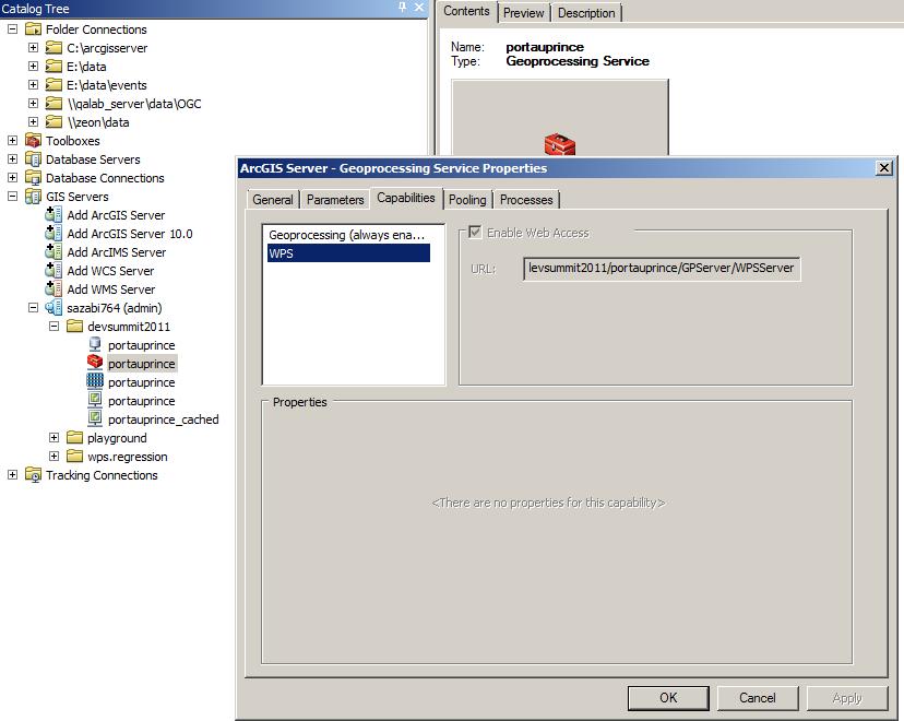
14 OGC Services in ArcGIS Server - Architecture Implemented as capabilities of ArcGIS Server services - Map Service - WMS, WCS, WFS, KML, WMTS (10.1) - Image Service - WMS, WCS, KML - GeoData Service - WCS, WFS, KML - Geoprocessing Service - WPS (10.1)
15 OGC Services in ArcGIS Server - Architecture Cont. Inherit from ArcGIS Server services - Rich functionalities from ArcObjects (cartography, geodatabase management, caching, geoprocessing etc.) - e.g. WMTS (GP tools for tiles), WPS (model builder and Python scripting environment) - Good authoring and publishing work flow - Consistency - Potential to publish and share in cloud - Scalability and Durability in distributed environment - Performance - Security mechanism
16 WMS WMS on MapService KML 1.0.0, 1.1.0, 1.1.1, GetCapabilities GetMap GetFeatureInfo ArcGIS Desktop client WebADF client KML on MapService KML 2.1 Add WMS on ImageService Styled Layer Descriptors (SLD) publish multiple styles at server side send external styles through SLD Filter Encoding (FE) in SLD Security (inherits ArcGIS Server Security Framework) Bug fixes KML on ImageService and GeoDataService KML through ArcGIS REST API Bug fixes WCS WCS on MapService WCS on ImageService WCS on GeoDataService 1.0.0, 1.1.0, GetCapabilities DescribeCoverage GetCoverage Add WMS on optimized map service Support SLD_BODY Support GetStyle Support GetLegendGraphic Support WMS-T (TIME) Bug fixes KML 2.2 (to OGC namespace) Support TIME in KML Bug fixes Bug fixes Updated Make WCS layer GP tool Add WCS on Optimized Map Service Add TIME support Bug fixes WMTS Add WMTS on cached map service Bug fixes Bug fixes WFS Make WCS layer GP tool ArcGIS Desktop client WFST on MapService WFST on GeoDataService OGC Services Add WFST (9.3 SP1) Performance enhancement Add WFS on Optimized MapService Support Bug fixes Add WFST on non-versioned geodatabase 9.2 Bug fixes 10.1 WPS GetCapabilities DescribeFeatureType GetFeature GetFeatureWithLock Transaction Data Interoperability Extension WFS to FeatureClass GP tool Add WPS on Geoprocessing Service

17 ArcGIS Server OGC versus REST Services
18 Demonstrations Authoring and Publishing (general) Dynamic Map & Tiled Map (WMS & WMTS) Feature Editing (WFS & WFS-T) Web Processing Service (WCS & WPS)
19 WMS in ArcGIS Server Serving map, legend, styles and limited feature data Version implemented 1.0.0, 1.1.0, and WMS interfaces implemented GetCapabilities (service level metadata) GetMap (map images) GetFeatureInfo (limited feature data, no geometry) GetStyles (styles in SLD xml, which are symbologies + filters) GetLegendGraphic (legend images) Highlights Support SLD 1.0 Filter encoding and Symbology encoding SLD and SLD_BODY GetStyles and GetLegendGraphic TIME Customized GetFeatureInfo response through XSLT Security (http basic, digest and token based)
20 WMTS in ArcGIS Server (10.1 Only) Serving pre-cached map tiles Version implemented WMTS interfaces implemented GetCapabilities (service level metadata) RESTful encoding only GetTile (tile images) RESTful encoding only Highlights Support both well-known tiling schemas (Google etc.) and customized tiling schema Benefit from cache creation and management tools of ArcGIS Server Performance and scalability Security (http basic, digest and token based) WMTS clients OpenLayers Gaia ArcGIS JavaScript API (as a customized tiled map service layer)
21 Demo Authoring and Publishing Recap Dynamic mapping Tiled Mapping
22 WFS in ArcGIS Server Data service, serving out geographic Feature data Version implemented 1.0.0, WFS interfaces implemented GetCapabilities (service level metadata) DescribeFeature (detailed feature schema) GetFeature (feature data) Transcation Operations ( Insert, Delete, Update, ) Highlights Supports Simple Features GML Supports Transactions using versioned Feature Classes Supports Transactions using non versioned Feature Classes Supports Query layers Supports Field Aliases and Visibility Constraints Supports DefaultMaxFeatures property Security (http basic, digest and token based)
23 Demo Feature Editing
24 WCS in ArcGIS Server Data service, serving out geographic coverage data Version implemented 1.0.0, 1.1.0, and WCS interfaces implemented GetCapabilities (service level metadata) DescribeCoverage (detailed coverage level metadata) GetCoverage (coverage data) Highlights Supported formats: GeoTiff, NITF, HDF, JPEG, JPEG2000, PNG; TIME (demo) IMAGE (ESRI specific parameter to request an individual raster in a raster catalog) Security (http basic, digest and token based)
25 WPS in ArcGIS Server (10.1 Only) Discover, describe and execute geospatial processes over the web Version implemented WPS interfaces implemented GetCapabilities (service level metadata) DescribeProcess (detailed metadata for individual process offering) Execute (to execute process in either synchronous or asyncronous mode) Highlights Benefit from out-of of-the-box Geoprocessing tools and models Benefit from scripting and model builder environment of ArcGIS DesktopD Security (http basic, digest and token based)
26 WPS Clients - 52North - OpenLayers client (JavaScript) - Java Library - udig (Java) - PyWPS OpenLayers client (JavaScript) - ZOO API (server-side JavaScript)
27
28
29
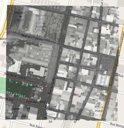
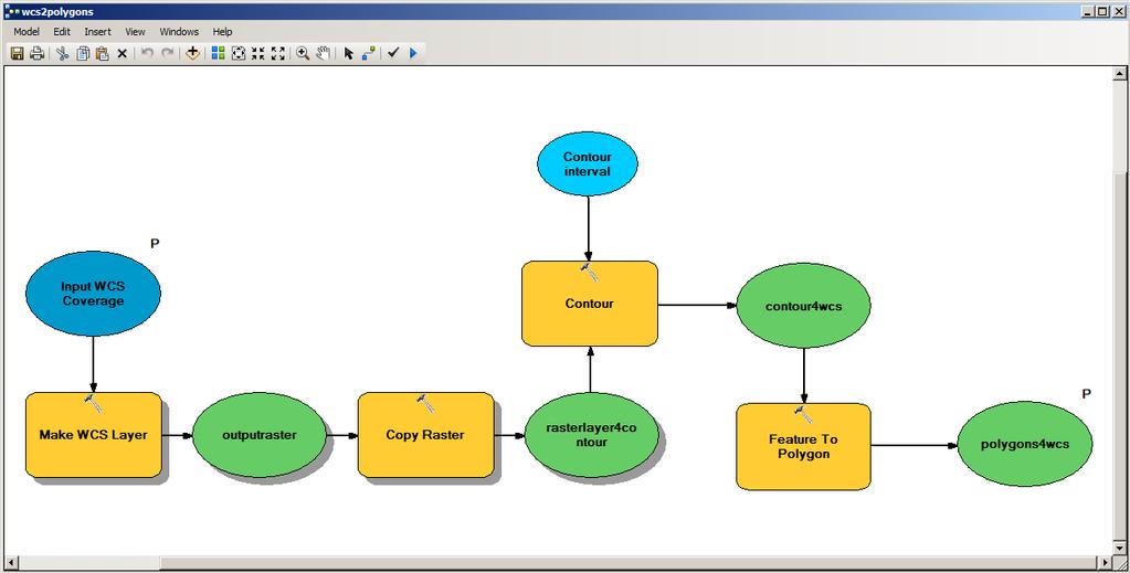
30 Demo - WCS & WPS ArcGIS Servers OGC WPS processing results OGC WCS Raster dataset Web client
31 OGC / ISO standards support ( ArcGIS 10.0) WMS + SLD + Filter Encoding Support + Time Support WFS + Transactions + Filter Encoding Support WCS +GeoTiff, NITF, HDF, JPEG, JPEG2000, PNG GML + Simple Features GML + OS Master Map, Top10NL, NATO, CityGML KML + OGC KML Metadata + ISO North American Profile + Inspire Profile CSW + OGC Core + ISO ebrim
32 10.0 Client Support for OGC Web services ArcMap - WMS, WFS, Simple Features GML, WCS, KML ArcGIS Explorer ( with custom tasks) - CS-W, WMC WebADF ArcMap ( with portal toolbar add-on) - WMS - Additional support for CS-W, WMC Geoportal Extension Mapviewer ArcMap ( with Data Interoperability Extension ) - WMS,WFS, WCS - WFS, GML (many application schemas) ArcGIS Explorer - WMS - KML
33 Resources ESRI Web Site - White papers - Product Support Matrix - OGC Compliancy Link: OGC Website Link: Opengeospatial.org


34 ArcGIS OGC Standards Compliant Implementations
35 OGC Web Services 2.0 Web Map Service 2.0 ( in the works) Web Features Service 2.0 ( OGC Implementation Specification) Web Coverage Service 2.0 (OGC Implementation Specification) Web Processing Service 2.0 (in the works) Sensor Observation Service 2.0 (in the works). Current OGC Standards Status
36 Questions?


37
Leveraging OGC Services in ArcGIS Server
 Esri International User Conference San Diego, CA Technical Workshops Jul.14 th 2011 Leveraging OGC Services in ArcGIS Server Satish Sankaran Yingqi Tang Agenda Interoperability
Leveraging OGC Standards on ArcGIS Server
 Leveraging OGC Standards on ArcGIS Server Satish Sankaran Interoperability and Standards Team James Michel III ESRI Intel Team ArcGIS Server Complete Interoperable Server-Based GIS Desktop Explorer Web
Leveraging OGC Services in ArcGIS Server. Satish Sankaran, Esri Yingqi Tang, Esri
 Leveraging OGC Services in ArcGIS Server Satish Sankaran, Esri Yingqi Tang, Esri GIS Creating and Managing Geo Information Products - Proprietary - Open Specifications - Standards Dissemination of Geo
Interoperability and Standards Supports in ArcGIS
 Esri International User Conference San Diego, California Technical Workshops July 26, 2012 Interoperability and Standards Supports in ArcGIS Satish Sankaran, Esri Yingqi Tang, Esri Agenda Esri s participation
Providing Interoperability Using the Open GeoServices REST Specification
 2013 Esri International User Conference July 8 12, 2013 San Diego, California Technical Workshop Providing Interoperability Using the Open GeoServices REST Specification Satish Sankaran Kevin Sigwart What
SDI SOLUTIONS FOR INSPIRE: TECHNOLOGIES SUPPORTING A FRAMEWORK OF COOPERATION
 SDI SOLUTIONS FOR INSPIRE: TECHNOLOGIES SUPPORTING A FRAMEWORK OF COOPERATION Roberto Lucchi 1, Marten Hogeweg 1, Guenther Pichler 2 1 Esri, Redlands, CA, USA 2 Esri Kranzberg, Germany 1 Vision INSPIRE
Achieving Interoperability using the ArcGIS Platform. Satish Sankaran Roberto Lucchi
 Achieving Interoperability using the ArcGIS Platform Satish Sankaran Roberto Lucchi Thank you Please fill out the session survey in your mobile app Select [Achieving Interoperability using the ArcGIS Platform]
How to become an INSPIRE node and fully exploit the investments made?
 How to become an INSPIRE node and fully exploit the investments made? Solution patterns for consumers: end users & developers (2/2) Roberto Lucchi 22 June 2010, Krakow 1 Geoportal extension Enabling discovery
Esri Support for Geospatial Standards
 APRIL 2017 ArcGIS Is Open and Interoperable Esri Support for Geospatial Standards Copyright 2017 Esri All rights reserved. Printed in the United States of America. The information contained in this document
Achieving Interoperability Using Open Standards
 FedGIS Conference February 24 25, 2016 Washington, DC Achieving Interoperability Using Open Standards Satish Sankaran Marten Hogeweg Agenda Understanding Interoperability What, Why and How? ArcGIS Platform
International Organization for Standardization Technical Committee 211 (ISO/TC211)
") Esri Support for Geospatial Standards: Open Geospatial Consortium (OGC) International Organization for Standardization Technical Committee 211 (ISO/TC211) An Esri White Paper April 2015 Copyright 2015
Esri Support for Geospatial Standards: Open Geospatial Consortium (OGC) International Organization for Standardization Technical Committee 211 (ISO/TC211) An Esri White Paper April 2015 Copyright 2015
Interoperability with ArcGIS
 Interoperability with ArcGIS Satish Sankaran Marten Hogeweg Agenda Understanding Interoperability What, Why and How? ArcGIS Platform An Open Platform Supporting Interoperability Examples from the real
Getting Started with ArcGIS for Server. Charmel Menzel and Ken Gorton
 Getting Started with ArcGIS for Server Charmel Menzel and Ken Gorton Agenda What is ArcGIS for Server? Types of Web services Publishing resources onto the Web Clients to ArcGIS for Server Editions and
SuperGIS Server 3.2 Value Edition Specification
 SuperGIS Server 3.2 Value Edition Specification 20140826 Specification 1. All of the services support SOAP (Simple Object Access Protocol). 2. Use map file created by SuperGIS Desktop as map services SuperGIS
Web Map Servers. Mark de Blois. Septembre 2016
 Web Map Servers Mark de Blois Septembre 2016 Learning Objectives After this lecture you will be able to understand web map servers as used in Web-GIS applications Introduction A Web Map Server is a computer
ArcGIS 9.2 Works as a Complete System
 ArcGIS 9.2 Works as a Complete System A New Way to Manage and Disseminate Geographic Knowledge Author/Serve/Use Maps Data Models Globes Metadata Use Desktop Explorer Web Map Viewer Mobile Open APIs Enterprise
What s New in ArcGIS Server 10
 What s New in ArcGIS Server 10 Derek Law ArcGIS Server Product Management What s s new in ArcGIS Server 10? Agenda Highlights: Enhanced Web mapping More powerful server-based analysis Geo-collaboration
Esri Support for Geospatial Standards: OGC and ISO/TC211. An Esri White Paper May 2015
 Esri Support for Geospatial Standards: OGC and ISO/TC211 An Esri White Paper May 2015 Copyright 2015 Esri All rights reserved. Printed in the United States of America. The information contained in this
SDI Tecnological Components and Standards
 SDI Tecnological Components and Standards Salvador Bayarri sbayarri@gmail.com World Bank Consultant Contents The SDI architecture model Software components: the SDI stack Basic services Metadata SDI access
INSPIRE: The ESRI Vision. Tina Hahn, GIS Consultant, ESRI(UK) Miguel Paredes, GIS Consultant, ESRI(UK)
 Miguel Paredes, GIS Consultant, ESRI(UK)") INSPIRE: The ESRI Vision Tina Hahn, GIS Consultant, ESRI(UK) Miguel Paredes, GIS Consultant, ESRI(UK) Overview Who are we? Introduction to ESRI Inc. and ESRI(UK) Presenters ArcGIS The ESRI Solution to
INSPIRE: The ESRI Vision Tina Hahn, GIS Consultant, ESRI(UK) Miguel Paredes, GIS Consultant, ESRI(UK) Overview Who are we? Introduction to ESRI Inc. and ESRI(UK) Presenters ArcGIS The ESRI Solution to
EUCOM/AFRICOM DEFENSE USER GROUP MEETING MARCH 2010 STUTTGART WELCOME!
 EUCOM/AFRICOM DEFENSE USER GROUP MEETING 23-25 MARCH 2010 STUTTGART WELCOME! AGENDA March 23, Tuesday 0800-0900 Registration 0900-0915 Welcome and Introductions 0915-1000 Getting Started with ArcGIS Server
ESRI & Interoperability. David Danko ISO TC 211 Metadata Project Leader OGC Metadata WG Chair ESRI Senior Consultant GIS Standards
 ESRI & Interoperability David Danko ISO TC 211 Metadata Project Leader OGC Metadata WG Chair ESRI Senior Consultant GIS Standards ddanko@esri.com GIS has always required Interoperability Social Factors
Managing Image Data on the ArcGIS Platform Options and Recommended Approaches
 Managing Image Data on the ArcGIS Platform Options and Recommended Approaches Peter Becker Petroleum requirements for imagery and raster Traditional solutions and issues Overview of ArcGIS imaging capabilities
PRODUCT BROCHURE ERDAS APOLLO MANAGING AND SERVING GEOSPATIAL INFORMATION
 PRODUCT BROCHURE ERDAS APOLLO MANAGING AND SERVING GEOSPATIAL INFORMATION ERDAS APOLLO Do you have large volumes of geospatial information, regularly updated data stores, and a distributed user base? Do
PRODUCT DESCRIPTION. ERDAS APOLLO 2014 Product Features and Comparisons
 PRODUCT DESCRIPTION ERDAS APOLLO 2014 Product Features and Comparisons ERDAS APOLLO is an enterprise-class, comprehensive data management, analysis, and delivery system enabling an organization to catalog,
GEOSPATIAL ERDAS APOLLO. Your Geospatial Business System for Managing and Serving Information
 GEOSPATIAL ERDAS APOLLO Your Geospatial Business System for Managing and Serving Information ERDAS APOLLO Do you have large volumes of data, a geographicallydistributed user base and rapidly changing
ERDAS APOLLO Managing and Serving Geospatial Information
 ERDAS APOLLO Managing and Serving Geospatial Information ERDAS APOLLO Do you have large volumes of geospatial information, regularly updated data stores, and a distributed user base? Do you need a single,
Introduction to ArcGIS Server Architecture and Services. Amr Wahba
 Introduction to ArcGIS Server 10.1 - Architecture and Services Amr Wahba awahba@esri.com Agenda Architecture Features Publishing Security Cloud Powerful GIS capabilities Delivered as Web services To help
Interactive Web Mapping: Overview
 Interactive Web Mapping: Overview Overview of how geospatial data is formatted requested supplied consumed by/for web technologies 2 Definitions Analysis exploring and modeling geospatial phenomena Mapping
Dynamic Situational Awareness. Through Developer Applications
 Dynamic Situational Awareness Through Developer Applications Mission Focused Applications Building Apps to support operations Agile Simple High-Performance Defense Developers GIS Simplifies Working With
Scientific and Multidimensional Raster Support in ArcGIS
 Scientific and Multidimensional Raster Support in ArcGIS Sudhir Raj Shrestha sshrestha@esri.com Brief breakdown Scientific Multidimensional data Ingesting Scientific MultiDim Data in ArcGIS Ingesting and
SMARTERDECISIONS. Geospatial Portal 2013 Open Interoperable GIS/Imagery Services with ERDAS Apollo 2013 and ERDAS Imagine 2013
 Geospatial Portal 2013 Open Interoperable GIS/Imagery Services with ERDAS Apollo 2013 and ERDAS Imagine 2013 Carahsoft Intergraph Government Solutions SMARTERDECISIONS Geospatial Portal 2013 Geospatial
Understanding and Using Metadata in ArcGIS. Adam Martin Marten Hogeweg Aleta Vienneau
 Understanding and Using Metadata in ArcGIS Adam Martin Marten Hogeweg Aleta Vienneau Adam Martin National Government Account Management R&D Open Data Marten Hogeweg National Government Professional Services
An Introduction to Data Interoperability
 Esri International User Conference San Diego, California 2012 Technical Workshops July 24/25 An Introduction to Data Interoperability Bruce Harold - Esri Dale Lutz Safe Software Background Why Data Interoperability?
ESRI Technology Update. Joe Holubar Larry Young
 ESRI Technology Update Joe Holubar Larry Young Continued Improvement Improving Quality and Extending and Refining Functionality First Half of 2009: Minor Update Release (ArcGIS 9.3.1) ArcGIS Explorer Fall
DATA SHARING AND DISCOVERY WITH ARCGIS SERVER GEOPORTAL EXTENSION. Clive Reece, Ph.D. ESRI Geoportal/SDI Solutions Team
 DATA SHARING AND DISCOVERY WITH ARCGIS SERVER GEOPORTAL EXTENSION Clive Reece, Ph.D. ESRI Geoportal/SDI Solutions Team Geoportal Extension for ArcGIS Server Context within an Enterprise Spatial Data Infrastructure
PRODUCT DESCRIPTION ERDAS APOLLO 2018 PRODUCT FEATURES AND COMPARISONS
 PRODUCT DESCRIPTION ERDAS APOLLO 2018 PRODUCT FEATURES AND COMPARISONS ERDAS APOLLO ERDAS APOLLO is an enterprise-class, comprehensive data management, analysis, and delivery system enabling an organization
Service Oriented Architecture For GIS Applications
 The 12 th International Conference of International Association for Computer Methods and Advances in Geomechanics (IACMAG) 1-6 October, 2008 Goa, India Service Oriented Architecture For GIS Applications
Leveraging metadata standards in ArcGIS to support Interoperability. Aleta Vienneau and Marten Hogeweg
 Leveraging metadata standards in ArcGIS to support Interoperability Aleta Vienneau and Marten Hogeweg Leveraging metadata standards in ArcGIS to support Interoperability Overview of metadata standards
Lecture note on the history and principles of geo-webservices
 A SHORT INTRODUCTION TO GEO-WEBSERVICES Lecture note on the history and principles of geo-webservices Barend Köbben Version 1.0 February 24, 2010 Contents 1 From monolithic to distributed GIS architectures
ArcGIS Online. The Road Ahead Geoff Mortson
 ArcGIS Online The Road Ahead Geoff Mortson gmortson@esricanada.com ArcGIS Online Easily create and share maps Delivered as intelligent maps Access on virtually any device anyone, anywhere Compliments and
ICIT. Brian Hiller ESRI Account Manger. What s new in ArcGIS 10
 ICIT Brian Hiller ESRI Account Manger What s new in ArcGIS 10 ArcGIS 10 Fast Easy Powerful Everywhere late June 2010 ArcGIS System for Geographic Information Desktop Server Mobile Online A System A Complete
Accessing OGC Services To access OGC WMS and WFS open the service in the directory that you want to consume, and click on either WMS or WFS.
 Using Web Services Web Services Overview This user guide contains instructions on how to consume a range of services through a range of both web based and desktop GIS applications. Web services are a live
Adopting the Appropriate GIS Web Service Technologies
 Adopting the Appropriate GIS Web Service Technologies Bo Guo, PE, PhD GIS/IT Integration Consultant Gistic Research Inc. UT & AZ Jake Payne Database Administrator & Architect State of Utah Department of
Integrated Map Tool. Overview, Current Status, and Things to Come
 Integrated Map Tool Overview, Current Status, and Things to Come Integrated Mapping and Analysis Tool (IMAT) map widget Integrated Mapping Tool IMAT Reusable components for portrayal, query, analysis,
Using the Network Common Data Form for storage of atmospheric data
 Using the Network Common Data Form for storage of atmospheric data Maarten Plieger Royal Netherlands Meteorological Institute The NetCDF4 data format (Network Common Data Form) is used within the ADAGUC
Developing a Free and Open Source Software based Spatial Data Infrastructure. Jeroen Ticheler
 Developing a Free and Open Source Software based Spatial Data Infrastructure Jeroen Ticheler 1 License This work is licensed under the Creative Commons Attribution-NonCommercial-ShareAlike 2.5 License.
Working with the ArcGIS Viewer for Flex Application Builder
 Working with the ArcGIS Viewer for Flex Application Builder Esri Canada User Conference St. John s November 15, 2012 Presented By: Greg Yetman gyetman@esri.ca Agenda This seminar is designed to help you
An Introduction to GIS for developers
 An Introduction to GIS for developers Part 4: GIS Sharing Canserina Kurnia & Tom Shippee Agenda Web GIS ArcGIS Online Cloud-based ArcGIS Server ArcGIS Server on-premises ArcGIS a complete platform discover,
Desktop. ArcGIS Server. ArcGIS
 Getting Started with ArcGIS Server Nakul Bhatia and David Crosby ESRI Charlotte 1 Agenda g Overview of ArcGIS Server 9.3.1 Working with GIS Services Using g Web GIS Service Clients ArcGIS Online Map Caching
Understanding and using Metadata across the ArcGIS Platform. Aleta Vienneau Marten Hogeweg
 Understanding and using Metadata across the ArcGIS Platform Aleta Vienneau Marten Hogeweg Understanding and using Metadata across the ArcGIS Platform Metadata fundamentals ArcGIS platform Road ahead Metadata
OGC Collaborative Platform Undercover
 OGC Collaborative Platform Undercover AGU Fall Meeting 2012 Dec 7, 2012 Greg Buehler; David Arctur; Luis E. Bermudez Open Geospatial Consortium 475 volunteer organizations 4307 Users 60 Standards 2 OGC
The French Geoportal : linking discovery and view network services. INSPIRE Conference Krakow
 The French Geoportal : linking discovery and view network services ( BRGM ) D.Richard (IGN) F. Robida Context of the French Geoportal The governance mechanism Transversal organisation based on the Ministry
Open source technologies and INSPIRE network services in Slovak environmental agency
 Open source technologies and INSPIRE network services in Slovak environmental agency Peter Mozolík, Martin Koška, Marek Žiačik, Martin Tuchyňa Slovak Environmental Agency (SEA) SEA role within slovak SDI
Tutorial International Standards. Web Map Server (WMS) & Web Feature Server (WFS) Overview
 & Web Feature Server (WFS) Overview") ISO/TC 211 17 th Plenary & Associated Meetings Berlin, Germany, DIN Institute / 2003-10-31 Advisory Group on Outreach Tutorial International Standards Web Map Server (WMS) & Web Feature Server (WFS) Overview
ISO/TC 211 17 th Plenary & Associated Meetings Berlin, Germany, DIN Institute / 2003-10-31 Advisory Group on Outreach Tutorial International Standards Web Map Server (WMS) & Web Feature Server (WFS) Overview
Introduction to ArcGIS Server 10.1
 Introduction to ArcGIS Server 10.1 E-Learning for the GIS Professional Any Time, Any Place! geospatialtraining.com Module Outline What is ArcGIS Server? GIS Resources and Services ArcGIS Server Components
ArcGIS for Server Michele Lundeen
 ArcGIS for Server 10.1 Michele Lundeen Summary Vision Installation and Configuration Architecture Publishing Functional Enhancements Cloud Migration and Best Practices Powerful GIS capabilities Delivered
Interoperability and gvsig
 CEN/TC 287 Madrid, 25-02-2009 Interoperability and gvsig Gabriel Carrión Rico Francisco José Peñarrubia Jorge Piera Llodrá Carlos Sánchez Periñán Director of gvsig project. Conselleria D' Infraestructures
Addressing Geospatial Big Data Management and Distribution Challenges ERDAS APOLLO & ECW
 Addressing Geospatial Big Data Management and Distribution Challenges ERDAS APOLLO & ECW Nouman Ahmed GeoSystems-Me (Hexagon Geospatial / ERDAS Regional Partner) Enterprise Solutions Architect Hexagon
Introduction to INSPIRE. Network Services
 Introduction to INSPIRE. Network Services European Commission Joint Research Centre Institute for Environment and Sustainability Digital Earth and Reference Data Unit www.jrc.ec.europa.eu Serving society
Discovery and Access of Geospatial Resources Using GIS Portal Toolkit Marten Hogeweg Product Manager GIS Portal Toolkit
 Discovery and Access of Geospatial Resources Using GIS Portal Toolkit Marten Hogeweg Product Manager GIS Portal Toolkit Outline Elements of Spatial Data Infrastructures Current trends Position of GIS portals
ArcGIS Viewer for Microsoft Silverlight An Introduction
 Esri International User Conference San Diego, CA Technical Workshops July 12, 2011 ArcGIS Viewer for Microsoft Silverlight An Introduction Art Haddad, Rich Zwaap, and Derek Law Agenda Background Product
Esri Geoportal Server
 Esri Geoportal Server Implementing a Spatial Data Infrastructure @martenhogeweg Esri Geoportal Server Extending ArcGIS to enable discovery and use of geospatial resources in heterogeneous environments
Best Practices for Designing Effective Map Services
 FedGIS Conference February 24 25, 2016 Washington, DC Best Practices for Designing Effective Map Services James Tedrick, Esri Matt Sokol, MD Dept. of Information Technology Web Mapping & Service Types
_ LUCIADFUSION V PRODUCT DATA SHEET _ LUCIADFUSION PRODUCT DATA SHEET
 _ LUCIADFUSION PRODUCT DATA SHEET V2016 LuciadFusion is the solution for efficient and effective use of geospatial data. It allows you to organize your data so that each user has one-click access to a
OPEN SOURCE SOLUTIONS FOR SURVEYORS
 2 nd Sabah International Surveyors Congress 11 th 12 th March 2014 OPEN SOURCE SOLUTIONS FOR SURVEYORS Presented By : Sr Alexander Chong Director, Jurukur Antarabangsa The Benefits Of Closed Proprietary
ESRI-Supported Open Geospatial Consortium, Inc., and ISO/TC 211 Standards
 ESRI-Supported Open Geospatial Consortium, Inc., and ISO/TC 211 Standards An ESRI White Paper June 2008 ESRI 380 New York St., Redlands, CA 92373-8100 USA TEL 909-793-2853 FAX 909-793-5953 E-MAIL info@esri.com
The Common Framework for Earth Observation Data. US Group on Earth Observations Data Management Working Group
 The Common Framework for Earth Observation Data US Group on Earth Observations Data Management Working Group Agenda USGEO and BEDI background Concise summary of recommended CFEOD standards today Full document
ArcGIS Online: Managing Data. Jeremy Bartley Sentha Sivabalan
 ArcGIS Online: Managing Data Jeremy Bartley (jbartley@esri.com) Sentha Sivabalan (ssivabalan@esri.com) Agenda Creating and managing content like Apps, Maps, Scenes and Layers in ArcGIS Today s Topics:
Carmenta Server Product Description
 White paper Carmenta Server Product Description Carmenta AB, Tel +46-31-775 57 00, www.carmenta.com P315 121RD, 2010 Carmenta reserves the right to change the specifications at any time and without notice.
Extend GIS. The Reach. Of Your GIS. Chris Cappelli Nathan Bennett
 Extend The Reach GIS Of Your GIS Chris Cappelli Nathan Bennett Where do your co-workers, managers, customers, and citizens go when they want to find or make a map? GIS is a practical system for problem
Using ESRI data in Autodesk ISD Products
 GI13-3 Using ESRI data in Autodesk ISD Products 1.5 hr. Class 02-Dec-03 3:30pm - 5:00pm Session Description: We will focus on using data in a variety of ESRI formats within the Autodesk GIS product line,
From Geoportal to Spatial Data Service Platform. Jani Kylmäaho National Land Survey of Finland Development Centre
 From Geoportal to Spatial Data Service Platform Jani Kylmäaho National Land Survey of Finland Development Centre Introduction National Land Survey of Finland - 1900 employees Development Centre - 120 employees
Leveraging metadata standards in ArcGIS to support Interoperability. David Danko and Aleta Vienneau
 Leveraging metadata standards in ArcGIS to support Interoperability David Danko and Aleta Vienneau Leveraging Metadata Standards in ArcGIS for Interoperability Why metadata and metadata standards? Overview
Web Services for Geospatial Mobile AR
 Web Services for Geospatial Mobile AR Introduction Christine Perey PEREY Research & Consulting cperey@perey.com Many popular mobile applications already use the smartphone s built-in sensors and receivers
Publishing image services in ArcGIS
 Esri International User Conference San Diego, California Technical Workshops July 26, 2012 Publishing image services in ArcGIS Wenxue Ju & Melanie Harlow What is an image service? A way to make image and
INTEGRATION OF DISASTER EVENT DATA INTO SPATIAL DATA INFRASTRUCTURES
 INTEGRATION OF DISASTER EVENT DATA INTO SPATIAL DATA INFRASTRUCTURES B. Stollberg a, *, T. De Groeve a, A. Hirner a, L. Vernaccini a, S. Paris a a Joint Research Centre of the European Commission, Institute
Getting Started with the ArcGIS Server JavaScript API
 Getting Started with the ArcGIS Server JavaScript API Agenda Introduction ArcGIS Server services and mashups REST API Services Directory JavaScript API ArcGIS Server Resource Center Dojo Maps, layers,
Designing and Using Basemaps. Jennifer Hughey
 Designing and Using Basemaps Jennifer Hughey Agenda The ArcGIS System Basemaps are a key component of your system Cartographic design considerations Using basemap layers in ArcMap Best practices for designing
RESOURCE ATLAS OVER THE WEB: PRELIMINARY RESULTS
 DISSEMINATION OF THE UAE SOLAR RESOURCE ATLAS OVER THE WEB: PRELIMINARY RESULTS and Research Center for Renewable Energy Mapping and Assessment Masdar Institute of Science and Technology, Abu Dhabi, United
A service oriented approach for geographical data sharing
 I3E 2005 Conference October 28-30, 2005" A service oriented approach for geographical data sharing Authors L. Vaccari 1, A. Ivanyuckovich 2, and M. Marchese 2 1 Autonomous Province of Trento, Trento, Italy
Hands-on Training INSPIRE Network Services
 1 April 2014 Hands-on Training INSPIRE Network Services Jacxsens Paul SADL KU Leuven 2 Overview How will we work? Lots of demo s & exercises Quick recap on Web Mapping Service (if necessary) Introduction
GeoServer, The Open Source Solution for the interoperable management of geospatial data
 GeoServer, The Open Source Solution for the interoperable management of geospatial data Ing. Andrea Aime, GeoSolutions Ing. Simone Giannecchini, GeoSolutions Outline Who is GeoSolutions? Quick intro to
Open Geospatial Consortium (OGC) and Web Services (WMS, WFS)
 and Web Services (WMS, WFS)") Open Geospatial Consortium (OGC) and Web Services (WMS, WFS) Responsible persons: Regula Stopper (Overall) Ionut Iosifescu Enescu (Content) Samuel Wiesmann (Revision) Olaf Schnabel (Revision) Content
Open Geospatial Consortium (OGC) and Web Services (WMS, WFS) Responsible persons: Regula Stopper (Overall) Ionut Iosifescu Enescu (Content) Samuel Wiesmann (Revision) Olaf Schnabel (Revision) Content
Getting Started with the ArcGIS API for JavaScript. Julie Powell, Paul Hann
 Getting Started with the ArcGIS API for JavaScript Julie Powell, Paul Hann Esri Developer Summit Berlin November 19 2012 Getting Started with the ArcGIS API for JavaScript ArcGIS for Server Is a Platform
Creating Mosaic Datasets and Publishing Image Services using Python
 Creating Mosaic Datasets and Publishing Image Services using Python Jie Zhang, Jamie Drisdelle Session Offering ID: 305 Overview Introduction to mosaic dataset Raster product for sensor imagery Automatic
ERDAS APOLLO v2013. What s New. SMARTERDECISIONS
 ERDAS APOLLO v2013 What s New. SMARTERDECISIONS 1 ERDAS APOLLO v2013 ERDAS APOLLO Professional: includes all the functionality of ERDAS APOLLO Advantage. In addition, it provides server side geoprocessing
Caching Tile Cache Creation & Management
 Exploring Options for Map Caching Tile Cache Creation & Management Presented By: Todd Wascher, Business Development Manager 04.21.2011 We Visualize Your World Whachutalkinbout? What we ll cover with this
Standards, GML and AIXM. Dr. David Burggraf Vice President Galdos Systems Inc
 Standards, and AIXM Dr. David Burggraf Vice President Galdos Systems Inc Copyright Galdos Systems Inc. May 6, 2010 Geography Markup Language: What is it? A modeling language for geographic features A set
Data Interoperability An Introduction
 Data Interoperability An Introduction Bruce Harold Dale Lutz - Esri Inc - Safe Software What is the Data Interoperability Extension? Moving data from app to app ETL in industry jargon If you are not the
Serving Imagery with ArcGIS Server 10.1
 Serving Imagery with ArcGIS Server 10.1 Presented by: André Piasta apiasta@esri.ca Esri Canada Users Conference Calgary, AB 28 May 2013 Today s Agenda ArcGIS server and image services Publishing of imagery
gvsig: towards 4D GIS
 gvsig: towards 4D GIS Salvador Bayarri IVER Salvador.Bayarri@iver.es www.gvsig.gva.es Contents gvsig's background & updates 3D visualization in gvsig Time and Animation in gvsig Implementation plan Demo
GeoNode Integration with SDIs and Community Mapping
 GeoNode Integration with SDIs and Community Mapping Salvador Bayarri sbayarri@gmail.com World Bank Consultant Contents Accessing other SDI services Catalog harvesting through Geonetwork Cascading external
Best Practices for Designing Effective Map Services
 2013 Esri International User Conference July 8 12, 2013 San Diego, California Technical Workshop Best Practices for Designing Effective Map Services Ty Fitzpatrick Tanu Hoque What s in this session Map
Understanding and Working with the OGC Geopackage. Keith Ryden Lance Shipman
 Understanding and Working with the OGC Geopackage Keith Ryden Lance Shipman Introduction - Introduction to Simple Features - What is the GeoPackage? - Esri Support - Looking ahead Geographic Things 3 Why
FGDC Standards Program. Presented by Julie Binder Maitra To ISO Standards in Action Workshop November 16, 2013
 FGDC Standards Program Presented by Julie Binder Maitra To ISO Standards in Action Workshop November 16, 2013 1 Topics Policies guiding FGDC standards program FGDC Participation in Non-Federal Standards
pgrouting extends the postgis/postgresql geospatial database to provide geospatial routing and other network analysis functionality.
 Workshop: 1 pgrouting extends the postgis/postgresql geospatial database to provide geospatial routing and other network analysis functionality. Attendee s previous knowledge: SQL (PostgreSQL, PostGIS)
Image Management and Dissemination. Peter Becker
 Image Management and Dissemination Peter Becker OUTLINE Requirements Intro to Mosaic Datasets Workflows & Demo Dynamic Mosaicking, On-the-fly processing Properties Differentiator Raster Catalog, ISDef,
Serving Large-Scale Coverages - How to Tame an Elephant
 Serving Large-Scale s - How to Tame an Elephant OGC Workshop 2 INSPIRE Conference Edinburgh, 29-jun-2011 Peter Baumann Jacobs University rasdaman GmbH OGC WCS.SWG chair OGC spec editor Sensor & Image Data
Using ArcGIS for Server. Javier Abadía, Esri España Peter McDaid, Esri UK
 Using ArcGIS for Server Javier Abadía, Esri España Peter McDaid, Esri UK 1. Intro 2. ArcGIS for Server = Geospatial Apps Server 3. Map Services Publishing Flow Apps 4. Spatial Functionality Services Publishing