Hydrological network detection for SWOT data. S. Lobry, F. Cao, R. Fjortoft, JM Nicolas, F. Tupin
|
|
|
- Giles Mitchell
- 5 years ago
- Views:
Transcription


1 Hydrological network detection for SWOT data S. Lobry, F. Cao, R. Fjortoft, JM Nicolas, F. Tupin IRS SPU avril 2016
2 SWOT mission Large water bodies detection Fine network detection Further works page 1
3 SWOT mission SWOT Surface Water and Ocean Topography Hydrology: estimation of the river and lake volumes, reservoirs, wetlands for a better understanding of the global water cycle Oceanography: global measurements of ocean surface topography with high spatial resolution to improve ocean circulation models (weather prediction, climate, navigation, ) NASA / CNES mission Launch planned in 2020 page 2
: single pass")

4 SWOT mission Specifications (images) Altimetry with interferometric SAR KaRIn instrument (Ka band radar interferometer): single pass interferometry Angles : 1 to 4 Ka band : 8.6mm Temporal cycle : every point on the earth measured twice every 21 days page 3

5 page 4 SWOT présentation, JC Souyris, CNES
6 page 5 SWOT présentation, JC Souyris, CNES
7 SWOT specifications Use of Ka band (8.6mm) Interferometric sensitivity depends on basis / λ High sensitivity to object roughness Sensitivity to tropospheric conditions Very small incidence angle ([0.6,4 ]) Lay-over effects Range resolution variation Strong land / water contrast page 6 SWOT présentation, JC Souyris, CNES

8 Mission SWOT page 7

9 KaRIn / SWOT requirements for water detection Water bodies Whose surface area /width exceeds 250x250 m² / 100m In region of moderate topographic relief Issues Variable water / land contrast, speckle impact Position and orientation of the river in the swath Pollution by other features? (roads?) page 8
10 SWOT mission ADT Challenges for the Algorithm Definition Team Fast and reliable processing methods for - River and water bodies detection - Height estimation (interferometric phase) Difficulties : - Fine networks - Speckle - Geometric deformations - Simulated data page 9


11 SWOT SAR data Spot image Simulated SWOT data North Camargue test site 4 incidence angles 3 simulation cases SWOT SAR image [pt4,c1]
12 Incidence angle [pt1] [pt2] [pt3] [pt4]

13 Incidence angle [pt1] [pt2] [pt3] [pt4]
14 SWOT mission Large water bodies detection Fine network detection Further works page 13

")

15 SAR data and statistics Data: complex electro-magnetic field (amplitude,, intensity ) Speckle: coherent imagery, interferences Goodman model (rough surfaces) page 14
16 SAR data and statistics One channel, Goodman model: Multi-look images: Intensity distribution: Gamma Amplitude distributions: Rayleigh-Nakagami page 15
17 SAR data and statistics D channels, Goodman model: Vectorial data: Circular complex Gaussian distribution: page 16
18 SAR data and statistics Multi-look data, Goodman model: Wishart distribution coherence phase page 17

 D=2")

 @DLR")


19 SAR data D=1 Amplitude data (classification, object recognition, ) D=2 different incidence angles Interferometric data: geometric information (elevation, D=3 different polarizations Polarimetric data Backscattering mechanisms (classification, object recognition, ) page

20 page 19 InSAR data
21 Probabilistic framework Bayesian classification Two classes : water / background Distributions of the SAR signals taken into account Regularization term page 20

22 Probabilistic framework Refinement Local learning of the class parameters Image partitioning for graph-cut based optimization page 21


23 Thèse S. Lobry page 22
24 SWOT mission Large water bodies detection Fine network detection Further works page 23
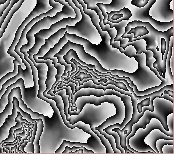
25 Fine network detection Context: Adaptation of a road detection algorithm for SAR data Method principle: Low-level line detector taking into account SAR statistics High level step connecting the detected candidates (contextual information) page 24
26 Step 1: Line detector Speckle noise: Nakagami distribution of SAR amplitude data Line detector based on the ratio of amplitude mean computed on stripes around the considered structure Statistical analysis of the ditribution of the ratiobased line detector page 25 In practice: - Width of the line between 3 and 5 pixels - 11 pixels length


27 page 26
28 Step 2:Markov random field on a line graph Graph construction: Line detection Graph = segment graph using the detected segments and all the «possible» connexions (edge = 2 segments share an extremity) Image representation Graph representation page 27 Detected seg. Added seg. extremity Nodes of G Edges of G


29 0 ou 1? page 28
30 Step 2:Markov random field on a line graph Markovian energy X binary field (road or not road label) Y line detector responses observed in the SAR data U( x y) s log P( y s x s ) c V c ( x c ) Likelihood of the observations for a given label Computed using the line detector response along the segment Prior information about the river shapes Riverss are long Curvature Few crossings page 29
31 Some results Quantitative evaluation (correctness / completeness): Water bodies / networks Positioning problems between mask / detection
32 SWOT mission Large water bodies detection Fine network detection Conclusion and further works page 31
33 Conclusion and further works Joint analysis of phase / amplitude data Combining both information (using complex field distributions phase / coherence / amplitude) Introduction of «prior» information Reference mask deformation (level set) Multi-temporal processing (class learning, algorithm initialization, multi-temporal denoising, ) Constraint: huge amount of data Simple and fast algorithms to compute the products page 32
34 References S. Lobry et al., Non uniform MRF for classification of SAR images, EUSAR 2016 R. Fjortoft et al. KaRIn on SWOT: Characteristics of Near-Nadir Ka- Band Interferometric SAR Imagery, IEEE TGRS, F. Cao et al., Extraction of water surface in simulated Ka-band SAR images of KaRIN on SWOT, IGARSS M. Negri et al., Junction-Aware Extraction and Regularization of Road Networks in SAR Images, IEEE TGRS 2006 R. Fjortoft et al. Unsupervised classification of radar images using hidden Markov chains and hidden Markov random fields. IEEE TGRS F. Tupin et al., Linear Feature Detection on SAR Images: Application to the Road Network, IEEE TGRS 1998 page 33
Upcoming altimeter measurements : nadir altimetry from Ku/C to Ka-band, SAR mode, interferometric SAR
 Upcoming altimeter measurements : nadir altimetry from Ku/C to Ka-band, SAR mode, interferometric SAR Jean-Claude Souyris CNES, Service Altimétrie & Radar Acknowledgments : Nathalie Steunou, Roger Fjortoft,
SAR time series. JM Nicolas F. Tupin
 SAR time series JM Nicolas F. Tupin Context Golden age of SAR sensors: improved spatial, polarimetric and temporal resolutions CSK TerraSAR-X Sentinel I RadarSAT-2 page 1 SAR sensors resolutions Polarimetric
SAR Interferometry. Dr. Rudi Gens. Alaska SAR Facility
 SAR Interferometry Dr. Rudi Gens Alaska SAR Facility 2 Outline! Relevant terms! Geometry! What does InSAR do?! Why does InSAR work?! Processing chain " Data sets " Coregistration " Interferogram generation
Sentinel-1 Toolbox. TOPS Interferometry Tutorial Issued May 2014
 Sentinel-1 Toolbox TOPS Interferometry Tutorial Issued May 2014 Copyright 2015 Array Systems Computing Inc. http://www.array.ca/ https://sentinel.esa.int/web/sentinel/toolboxes Interferometry Tutorial
Interferometric processing. Rüdiger Gens
 Rüdiger Gens Why InSAR processing? extracting three-dimensional information out of a radar image pair covering the same area digital elevation model change detection 2 Processing chain 3 Processing chain
Do It Yourself 8. Polarization Coherence Tomography (P.C.T) Training Course
 Training Course") Do It Yourself 8 Polarization Coherence Tomography (P.C.T) Training Course 1 Objectives To provide a self taught introduction to Polarization Coherence Tomography (PCT) processing techniques to enable
Do It Yourself 8 Polarization Coherence Tomography (P.C.T) Training Course 1 Objectives To provide a self taught introduction to Polarization Coherence Tomography (PCT) processing techniques to enable
Mission Status and Data Availability: TanDEM-X
 Mission Status and Data Availability: TanDEM-X Irena Hajnsek, Thomas Busche, Alberto Moreira & TanDEM-X Team Microwaves and Radar Institute, German Aerospace Center irena.hajnsek@dlr.de 26-Jan-2009 Outline
InSAR Operational and Processing Steps for DEM Generation
 InSAR Operational and Processing Steps for DEM Generation By F. I. Okeke Department of Geoinformatics and Surveying, University of Nigeria, Enugu Campus Tel: 2-80-5627286 Email:francisokeke@yahoo.com Promoting
IMPROVING DEMS USING SAR INTERFEROMETRY. University of British Columbia. ABSTRACT
 IMPROVING DEMS USING SAR INTERFEROMETRY Michael Seymour and Ian Cumming University of British Columbia 2356 Main Mall, Vancouver, B.C.,Canada V6T 1Z4 ph: +1-604-822-4988 fax: +1-604-822-5949 mseymour@mda.ca,
In addition, the image registration and geocoding functionality is also available as a separate GEO package.
 GAMMA Software information: GAMMA Software supports the entire processing from SAR raw data to products such as digital elevation models, displacement maps and landuse maps. The software is grouped into
Synthetic Aperture Radar (SAR) Polarimetry for Wetland Mapping & Change Detection
 Polarimetry for Wetland Mapping & Change Detection") Synthetic Aperture Radar (SAR) Polarimetry for Wetland Mapping & Change Detection Jennifer M. Corcoran, M.S. Remote Sensing & Geospatial Analysis Laboratory Natural Resource Science & Management PhD Program
Synthetic Aperture Radar (SAR) Polarimetry for Wetland Mapping & Change Detection Jennifer M. Corcoran, M.S. Remote Sensing & Geospatial Analysis Laboratory Natural Resource Science & Management PhD Program
MULTI-TEMPORAL SAR CHANGE DETECTION AND MONITORING
 MULTI-TEMPORAL SAR CHANGE DETECTION AND MONITORING S. Hachicha, F. Chaabane Carthage University, Sup Com, COSIM laboratory, Route de Raoued, 3.5 Km, Elghazala Tunisia. ferdaous.chaabene@supcom.rnu.tn KEY
InSAR DEM; why it is better?
 InSAR DEM; why it is better? What is a DEM? Digital Elevation Model (DEM) refers to the process of demonstrating terrain elevation characteristics in 3-D space, but very often it specifically means the
Interferometry Tutorial with RADARSAT-2 Issued March 2014 Last Update November 2017
 Sentinel-1 Toolbox with RADARSAT-2 Issued March 2014 Last Update November 2017 Luis Veci Copyright 2015 Array Systems Computing Inc. http://www.array.ca/ http://step.esa.int with RADARSAT-2 The goal of
The 2017 InSAR package also provides support for the generation of interferograms for: PALSAR-2, TanDEM-X
 Technical Specifications InSAR The Interferometric SAR (InSAR) package can be used to generate topographic products to characterize digital surface models (DSMs) or deformation products which identify
Repeat-pass SAR Interferometry Experiments with Gaofen-3: A Case Study of Ningbo Area
 Repeat-pass SAR Interferometry Experiments with Gaofen-3: A Case Study of Ningbo Area Tao Zhang, Xiaolei Lv, Bing Han, Bin Lei and Jun Hong Key Laboratory of Technology in Geo-spatial Information Processing
Sentinel-1 Toolbox. Interferometry Tutorial Issued March 2015 Updated August Luis Veci
 Sentinel-1 Toolbox Interferometry Tutorial Issued March 2015 Updated August 2016 Luis Veci Copyright 2015 Array Systems Computing Inc. http://www.array.ca/ http://step.esa.int Interferometry Tutorial The
PSI Precision, accuracy and validation aspects
 PSI Precision, accuracy and validation aspects Urs Wegmüller Charles Werner Gamma Remote Sensing AG, Gümligen, Switzerland, wegmuller@gamma-rs.ch Contents Aim is to obtain a deeper understanding of what
SWOT LAKE PRODUCT. Claire POTTIER(CNES) and P. Callahan (JPL) SWOT ADT project team J.F. Cretaux, T. Pavelsky SWOT ST Hydro leads
 and P. Callahan (JPL) SWOT ADT project team J.F. Cretaux, T. Pavelsky SWOT ST Hydro leads") SWOT LAKE PRODUCT Claire POTTIER(CNES) and P. Callahan (JPL) SWOT ADT project team J.F. Cretaux, T. Pavelsky SWOT ST Hydro leads Lake, Climate and Remote Sensing Workshop Toulouse June 1&2 2017 High Rate
SWOT LAKE PRODUCT Claire POTTIER(CNES) and P. Callahan (JPL) SWOT ADT project team J.F. Cretaux, T. Pavelsky SWOT ST Hydro leads Lake, Climate and Remote Sensing Workshop Toulouse June 1&2 2017 High Rate
SENTINEL-1 Toolbox. SAR Basics Tutorial Issued March 2015 Updated August Luis Veci
 SENTINEL-1 Toolbox SAR Basics Tutorial Issued March 2015 Updated August 2016 Luis Veci Copyright 2015 Array Systems Computing Inc. http://www.array.ca/ http://step.esa.int SAR Basics Tutorial The goal
Terrain correction. Backward geocoding. Terrain correction and ortho-rectification. Why geometric terrain correction? Rüdiger Gens
 Terrain correction and ortho-rectification Terrain correction Rüdiger Gens Why geometric terrain correction? Backward geocoding remove effects of side looking geometry of SAR images necessary step to allow
GAMMA Interferometric Point Target Analysis Software (IPTA): Users Guide
: Users Guide") GAMMA Interferometric Point Target Analysis Software (IPTA): Users Guide Contents User Handbook Introduction IPTA overview Input data Point list generation SLC point data Differential interferogram point
GAMMA Interferometric Point Target Analysis Software (IPTA): Users Guide Contents User Handbook Introduction IPTA overview Input data Point list generation SLC point data Differential interferogram point
RADARGRAMMETRY AND INTERFEROMETRY SAR FOR DEM GENERATION
 RADARGRAMMETRY AND INTERFEROMETRY SAR FOR DEM GENERATION Jung Hum Yu 1, Xiaojing Li, Linlin Ge, and Hsing-Chung Chang School of Surveying and Spatial Information Systems University of New South Wales,
MULTI-TEMPORAL INTERFEROMETRIC POINT TARGET ANALYSIS
 MULTI-TEMPORAL INTERFEROMETRIC POINT TARGET ANALYSIS U. WEGMÜLLER, C. WERNER, T. STROZZI, AND A. WIESMANN Gamma Remote Sensing AG. Thunstrasse 130, CH-3074 Muri (BE), Switzerland wegmuller@gamma-rs.ch,
BUILT-UP AREAS MAPPING AT GLOBAL SCALE BASED ON ADAPATIVE PARAMETRIC THRESHOLDING OF SENTINEL-1 INTENSITY & COHERENCE TIME SERIES
 BUILT-UP AREAS MAPPING AT GLOBAL SCALE BASED ON ADAPATIVE PARAMETRIC THRESHOLDING OF SENTINEL-1 INTENSITY & COHERENCE TIME SERIES M. Chini, R. Pelich, R. Hostache, P. Matgen MultiTemp 2017 June 27-29,
A Survey of Novel Airborne SAR Signal Processing Techniques and Applications for DLR s F-SAR Sensor
 A Survey of Novel Airborne SAR Signal Processing Techniques and Applications for DLR s F-SAR Sensor M. Jäger, M. Pinheiro, O. Ponce, A. Reigber, R. Scheiber Microwaves and Radar Institute, German Aerospace
Coherence Based Polarimetric SAR Tomography
 I J C T A, 9(3), 2016, pp. 133-141 International Science Press Coherence Based Polarimetric SAR Tomography P. Saranya*, and K. Vani** Abstract: Synthetic Aperture Radar (SAR) three dimensional image provides
Near Real-Time Maritime Object Recognition using Multiple SAR Satellite Sensors
 Near Real-Time Maritime Object Recognition using Multiple SAR Satellite Sensors Björn Tings, Domenico Velotto, Sergey Voinov, Andrey Pleskachevsky, Sven Jacobsen German Aerospace Center (DLR) PORSEC 2016
Course Outline (1) #6 Data Acquisition for Built Environment. Fumio YAMAZAKI
 #6 Data Acquisition for Built Environment. Fumio YAMAZAKI") AT09.98 Applied GIS and Remote Sensing for Disaster Mitigation #6 Data Acquisition for Built Environment 9 October, 2002 Fumio YAMAZAKI yamazaki@ait.ac.th http://www.star.ait.ac.th/~yamazaki/ Course Outline
AT09.98 Applied GIS and Remote Sensing for Disaster Mitigation #6 Data Acquisition for Built Environment 9 October, 2002 Fumio YAMAZAKI yamazaki@ait.ac.th http://www.star.ait.ac.th/~yamazaki/ Course Outline
Metrology and Sensing
 Metrology and Sensing Lecture 4: Fringe projection 2016-11-08 Herbert Gross Winter term 2016 www.iap.uni-jena.de 2 Preliminary Schedule No Date Subject Detailed Content 1 18.10. Introduction Introduction,
DETECTION AND QUANTIFICATION OF ROCK GLACIER. DEFORMATION USING ERS D-InSAR DATA
 DETECTION AND QUANTIFICATION OF ROCK GLACIER DEFORMATION USING ERS D-InSAR DATA Lado W. Kenyi 1 and Viktor Kaufmann 2 1 Institute of Digital Image Processing, Joanneum Research Wastiangasse 6, A-8010 Graz,
An empirical model for interferometric coherence
 An empirical model for interferometric coherence Chaabane F. a, Tupin F. b and Maître H. b a URISA-SUP COM, 3.5 route de Raoued, 283 Ariana, Tunisie b GET-Télécom-Paris - CNRS URA 82, 46 rue Barrault,
The Staggered SAR Concept: Imaging a Wide Continuous Swath with High Resolution
 The Staggered SAR Concept: Imaging a Wide Continuous Swath with High Resolution Michelangelo Villano *, Gerhard Krieger *, Alberto Moreira * * German Aerospace Center (DLR), Microwaves and Radar Institute
ALOS PALSAR. Orthorectification Tutorial Issued March 2015 Updated August Luis Veci
 ALOS PALSAR Orthorectification Tutorial Issued March 2015 Updated August 2016 Luis Veci Copyright 2015 Array Systems Computing Inc. http://www.array.ca/ http://step.esa.int ALOS PALSAR Orthorectification
Operational process interferometric for the generation of a digital model of ground Applied to the couple of images ERS-1 ERS-2 to the area of Algiers
 Operational process interferometric for the generation of a digital model of ground Applied to the couple of images ERS-1 ERS-2 to the area of Algiers F. Hocine, M.Ouarzeddine, A. elhadj-aissa,, M. elhadj-aissa,,
SAR change detection based on Generalized Gamma distribution. divergence and auto-threshold segmentation
 SAR change detection based on Generalized Gamma distribution divergence and auto-threshold segmentation GAO Cong-shan 1 2, ZHANG Hong 1*, WANG Chao 1 1.Center for Earth Observation and Digital Earth, CAS,
IMAGING WITH SYNTHETIC APERTURE RADAR
 ENGINEERING SCIENCES ; t rical Bngi.net IMAGING WITH SYNTHETIC APERTURE RADAR Didier Massonnet & Jean-Claude Souyris EPFL Press A Swiss academic publisher distributed by CRC Press Table of Contents Acknowledgements
MULTI-TEMPORAL SAR DATA FILTERING FOR LAND APPLICATIONS. I i is the estimate of the local mean backscattering
 MULTI-TEMPORAL SAR DATA FILTERING FOR LAND APPLICATIONS Urs Wegmüller (1), Maurizio Santoro (1), and Charles Werner (1) (1) Gamma Remote Sensing AG, Worbstrasse 225, CH-3073 Gümligen, Switzerland http://www.gamma-rs.ch,
SAR Interferogram Phase Filtering Using Wavelet Transform
 Formatted: Font: 16 pt, Nazanin, 16 pt, (Complex) Farsi, 12 pt SAR Interferogram Phase Filtering Using Wavelet Transform V. Akbari, M. Motagh and M. A. Rajabi 1 Dept. o Surveying Eng., University College
ARTIFICIAL SCATTERERS FOR S.A.R. INTERFEROMETRY
 ARTIFICIAL SCATTERERS FOR S.A.R. INTERFEROMETRY Parizzi A. (1), Perissin D. (1), Prati C. (1), Rocca F. (1) (1) Politecnico di Milano, Via Ponzio 34/5, 20133 Milano, Italy ABSTRACT. The evaluation of land
Geometric and Radiometric Calibration of RADARSAT Images. David Small, Francesco Holecz, Erich Meier, Daniel Nüesch, and Arnold Barmettler
 RADARSAT Terrain Geocoding and Radiometric Correction over Switzerland Geometric and Radiometric Calibration of RADARSAT Images David Small, Francesco Holecz, Erich Meier, Daniel Nüesch, and Arnold Barmettler
AUTOMATIC INTERPRETATION OF HIGH RESOLUTION SAR IMAGES: FIRST RESULTS OF SAR IMAGE SIMULATION FOR SINGLE BUILDINGS
 AUTOMATIC INTERPRETATION OF HIGH RESOLUTION SAR IMAGES: FIRST RESULTS OF SAR IMAGE SIMULATION FOR SINGLE BUILDINGS J. Tao *, G. Palubinskas, P. Reinartz German Aerospace Center DLR, 82234 Oberpfaffenhofen,
Airborne Differential SAR Interferometry: First Results at L-Band
 1516 IEEE TRANSACTIONS ON GEOSCIENCE AND REMOTE SENSING, VOL. 41, NO. 6, JUNE 2003 Airborne Differential SAR Interferometry: First Results at L-Band Andreas Reigber, Member, IEEE, and Rolf Scheiber Abstract
Flood detection using radar data Basic principles
 Flood detection using radar data Basic principles André Twele, Sandro Martinis and Jan-Peter Mund German Remote Sensing Data Center (DFD) 1 Overview Introduction Basic principles of flood detection using
Unsupervised Oil Spill Detection in SAR Imagery through an Estimator of Local Regularity
 Unsupervised Oil Spill Detection in SAR Imagery through an Estimator of Local Regularity Mariví Tello,, Carlos López-Martínez,, Jordi J. Mallorquí. Remote Sensing Laboratory (RSLab( RSLab) Signal Theory
PolSARpro v4.03 Forest Applications
 PolSARpro v4.03 Forest Applications Laurent Ferro-Famil Lecture on polarimetric SAR Theory and applications to agriculture & vegetation Thursday 19 April, morning Pol-InSAR Tutorial Forest Application
DIGITAL IMAGE ANALYSIS. Image Classification: Object-based Classification
 DIGITAL IMAGE ANALYSIS Image Classification: Object-based Classification Image classification Quantitative analysis used to automate the identification of features Spectral pattern recognition Unsupervised
CLASSIFICATION STRATEGIES FOR POLARIMETRIC SAR SEA ICE DATA
 CLASSIFICATION STRATEGIES FOR POLARIMETRIC SAR SEA ICE DATA Bernd Scheuchl (), Irena Hajnsek (), Ian Cumming () () Department of Electrical and Computer Engineering, University of British Columbia 56 Main
OIL SPILL MAPPING WITH SENTINEL-1 AUGUST 2017, KUWAIT
 _p TRAINING KIT OCEA03 OIL SPILL MAPPING WITH SENTINEL-1 AUGUST 2017, KUWAIT Table of Contents 1 Introduction to RUS... 3 2 Oil spill mapping background... 3 3 Training... 3 3.1 Data used... 3 3.2 Software
Interferometric Synthetic-Aperture Radar (InSAR) Basics
 Basics") Interferometric Synthetic-Aperture Radar (InSAR) Basics 1 Outline SAR limitations Interferometry SAR interferometry (InSAR) Single-pass InSAR Multipass InSAR InSAR geometry InSAR processing steps Phase
Interferometric Synthetic-Aperture Radar (InSAR) Basics 1 Outline SAR limitations Interferometry SAR interferometry (InSAR) Single-pass InSAR Multipass InSAR InSAR geometry InSAR processing steps Phase
RESOLUTION enhancement is achieved by combining two
 IEEE GEOSCIENCE AND REMOTE SENSING LETTERS, VOL. 3, NO. 1, JANUARY 2006 135 Range Resolution Improvement of Airborne SAR Images Stéphane Guillaso, Member, IEEE, Andreas Reigber, Member, IEEE, Laurent Ferro-Famil,
GEOG 4110/5100 Advanced Remote Sensing Lecture 2
 GEOG 4110/5100 Advanced Remote Sensing Lecture 2 Data Quality Radiometric Distortion Radiometric Error Correction Relevant reading: Richards, sections 2.1 2.8; 2.10.1 2.10.3 Data Quality/Resolution Spatial
SAR IMAGE PROCESSING FOR CROP MONITORING
 SAR IMAGE PROCESSING FOR CROP MONITORING Anne Orban, Dominique Derauw, and Christian Barbier Centre Spatial de Liège Université de Liège cbarbier@ulg.ac.be Agriculture and Vegetation at a Local Scale Habay-La-Neuve,
Terrafirma: a Pan-European Terrain motion hazard information service.
 Terrafirma: a Pan-European Terrain motion hazard information service www.terrafirma.eu.com The Future of Terrafirma - Wide Area Product Nico Adam and Alessandro Parizzi DLR Oberpfaffenhofen Terrafirma
Ground Subsidence Monitored by L-band Satellite Radar. Interferometry
 Ground Subsidence Monitored by L-band Satellite Radar Interferometry Hsing-Chung Chang, Ming-han Chen, Lijiong Qin, Linlin Ge and Chris Rizos Satellite Navigation And Positioning Group School of Surveying
fraction of Nyquist
 differentiator 4 2.1.2.3.4.5.6.7.8.9 1 1 1/integrator 5.1.2.3.4.5.6.7.8.9 1 1 gain.5.1.2.3.4.5.6.7.8.9 1 fraction of Nyquist Figure 1. (top) Transfer functions of differential operators (dotted ideal derivative,
AMBIGUOUS PSI MEASUREMENTS
 AMBIGUOUS PSI MEASUREMENTS J. Duro (1), N. Miranda (1), G. Cooksley (1), E. Biescas (1), A. Arnaud (1) (1). Altamira Information, C/ Còrcega 381 387, 2n 3a, E 8037 Barcelona, Spain, Email: javier.duro@altamira
Radar Data Processing, Quality Analysis and Level-1b Product Generation for AGRISAR and EAGLE campaigns
 Radar Data Processing, Quality Analysis and Level-1b Product Generation for AGRISAR and EAGLE campaigns German Aerospace Center (DLR) R. Scheiber, M. Keller, J. Fischer, R. Horn, I. Hajnsek Outline E-SAR
ON THE PHYSICAL NATURE OF URBAN SAR PERMANENT SCATTERERS
 ON THE PHYSICAL NATURE OF URBAN SAR PERMANENT SCATTERERS Daniele Perissin (1), Claudio Prati (1) (1) Politecnico di Milano, Piazza L. da Vinci 32, 20133 Milano, Italy, Email: perissin@elet.polimi.it KEY
S2 MPC Data Quality Report Ref. S2-PDGS-MPC-DQR
 S2 MPC Data Quality Report Ref. S2-PDGS-MPC-DQR 2/13 Authors Table Name Company Responsibility Date Signature Written by S. Clerc & MPC Team ACRI/Argans Technical Manager 2015-11-30 Verified by O. Devignot
EVALUATION OF CORRELATION CRITERIA FOR SAR IMAGES
 EVALUATION OF CORRELATION CRITERIA FOR SAR IMAGES Florence TUPIN, Michel ROUX, Saeid HOMAYOUNI GET - Télécom-Paris - UMR 5141 LTCI - Département TSI 46 rue Barrault, 75013 Paris - France orence.tupin@enst.fr
OPERATIONAL SHIP DETECTION & RAPID URBAN MAPPING : EXPLORING DIVERSE METHODOLOGICAL APPROACHES IN OBJECT RECOGNTION AND SATELLITE IMAGE CLASSIFICATION
 Journées ORFEO Méthodo 10-11 Janvier 2008 OPERATIONAL SHIP DETECTION & RAPID URBAN MAPPING : EXPLORING DIVERSE METHODOLOGICAL APPROACHES IN OBJECT RECOGNTION AND SATELLITE IMAGE CLASSIFICATION Michel Petit,
Playa del Rey, California InSAR Ground Deformation Monitoring
 Document Title Playa del Rey, California InSAR Ground Deformation Monitoring Prepared By: (signature / date) Ref.: RV-14524 Project Manager: xxxxxx July 13, 2009 SUBMITTED TO: ATTN: Mr. Rick Gailing Southern
TANDEM-X: DEM ACQUISITION IN THE THIRD YEAR ERA
 TANDEM-X: DEM ACQUISITION IN THE THIRD YEAR ERA D. Borla Tridon, M. Bachmann, D. Schulze, C. J. Ortega Miguez, M. D. Polimeni, M. Martone and TanDEM-X Team Microwaves and Radar Institute, DLR 5 th International
SIMULATION AND VISUALIZATION IN THE EDUCATION OF COHERENT OPTICS
 SIMULATION AND VISUALIZATION IN THE EDUCATION OF COHERENT OPTICS J. KORNIS, P. PACHER Department of Physics Technical University of Budapest H-1111 Budafoki út 8., Hungary e-mail: kornis@phy.bme.hu, pacher@phy.bme.hu
Combining Airborne LIDAR and Satellite RADAR for a Dynamic DEM. Ramon Hanssen, Delft University of Technology
 Combining Airborne LIDAR and Satellite RADAR for a Dynamic DEM Ramon Hanssen, Delft University of Technology 1 Release 27 September 2 Land surface elevation H(t) = H(t 0 ) + dh(dt) dt Elevation at time
EXTRACTION OF COASTLINES WITH FUZZY APPROACH USING SENTINEL-1 SAR IMAGE
 EXTRACTION OF COASTLINES WITH FUZZY APPROACH USING SENTINEL-1 SAR IMAGE N.Demir a,b*, M.Kaynarca a, S.Oy a a Akdeniz University, Dept.of Space Science and Technologies b Akdeniz University, Remote Sensing
Memorandum. Clint Slatton Prof. Brian Evans Term project idea for Multidimensional Signal Processing (EE381k)
") Memorandum From: To: Subject: Date : Clint Slatton Prof. Brian Evans Term project idea for Multidimensional Signal Processing (EE381k) 16-Sep-98 Project title: Minimizing segmentation discontinuities in
Memorandum From: To: Subject: Date : Clint Slatton Prof. Brian Evans Term project idea for Multidimensional Signal Processing (EE381k) 16-Sep-98 Project title: Minimizing segmentation discontinuities in
Concept and methodology of SAR Interferometry technique
 Concept and methodology of SAR Interferometry technique March 2016 Differen;al SAR Interferometry Young s double slit experiment - Construc;ve interference (bright) - Destruc;ve interference (dark) http://media-2.web.britannica.com/eb-media/96/96596-004-1d8e9f0f.jpg
Playa del Rey, California InSAR Ground Deformation Monitoring
 Playa del Rey, California InSAR Ground Deformation Monitoring Master Document Ref.: RV-14524 July 13, 2009 SUBMITTED TO: ATTN: Mr. Rick Gailing Southern California Gas Company 555 W. Fifth Street (Mail
Polarimetric UHF Calibration for SETHI
 PIERS ONLINE, VOL. 6, NO. 5, 21 46 Polarimetric UHF Calibration for SETHI H. Oriot 1, C. Coulombeix 1, and P. Dubois-Fernandez 2 1 ONERA, Chemin de la Hunière, F-91761 Palaiseau cedex, France 2 ONERA,
Metrology and Sensing
 Metrology and Sensing Lecture 4: Fringe projection 2017-11-09 Herbert Gross Winter term 2017 www.iap.uni-jena.de 2 Preliminary Schedule No Date Subject Detailed Content 1 19.10. Introduction Introduction,
URBAN FOOTPRINT MAPPING WITH SENTINEL-1 DATA
 URBAN FOOTPRINT MAPPING WITH SENTINEL-1 DATA Data: Sentinel-1A IW SLC 1SSV: S1A_IW_SLC 1SSV_20160102T005143_20160102T005208_009308_00D72A_849D S1A_IW_SLC 1SSV_20160126T005142_20160126T005207_009658_00E14A_49C0
INSAR DEMS; ACHIEVEMENTS AND BENEFITS
 INSAR DEMS; ACHIEVEMENTS AND BENEFITS Parviz TARIKHI, Iran Key words: remote sensing, InSAR, DEM, deformation measurement, Iran SUMMARY InSAR is a radar technique for combining synthetic aperture radar
TerraS ar-x / T ande M-X Capabilities & Utility
 TerraS ar-x / T ande M-X Capabilities & Utility Dr. Oliver Lang Infoterra Germany Astrium Services GEO-Information Services Mailing: 88039 Friedrichshafen Germany Tel +49-7545-8-5520 Fax +49 7545-8-1337
LIDAR MAPPING FACT SHEET
 1. LIDAR THEORY What is lidar? Lidar is an acronym for light detection and ranging. In the mapping industry, this term is used to describe an airborne laser profiling system that produces location and
WORCESTER POLYTECHNIC INSTITUTE
 WORCESTER POLYTECHNIC INSTITUTE MECHANICAL ENGINEERING DEPARTMENT Optical Metrology and NDT ME-593L, C 2018 Introduction: Wave Optics January 2018 Wave optics: coherence Temporal coherence Review interference
TanDEM-X Interferometric Processing Chain and SAR Products. Thomas Fritz H. Breit, M. Eineder, M. Lachaise & ITP Development Team
 TanDEM-X Interferometric Processing Chain and SAR Products Thomas Fritz H. Breit, M. Eineder, M. Lachaise & ITP Development Team TanDEM-X Science Meeting Nov. 2008 From Acquisitions to Products - The TanDEM-X
2-PASS DIFFERENTIAL INTERFEROMETRY IN THE AREA OF THE SLATINICE ABOVE- LEVEL DUMP. Milan BOŘÍK 1
 2-PASS DIFFERENTIAL INTERFEROMETRY IN THE AREA OF THE SLATINICE ABOVE- LEVEL DUMP Milan BOŘÍK 1 1 Department of Mathematics, Faculty of Civil Engineering, Czech Technical University in Prague, Thákurova
Interferometric Evaluation of Sentinel-1A TOPS data
 Interferometric Evaluation of Sentinel-1A TOPS data N. Yague-Martinez, F. Rodriguez Gonzalez, R. Brcic, R. Shau Remote Sensing Technology Institute. DLR, Germany ESTEC/Contract No. 4000111074/14/NL/MP/lf
Lateral Ground Movement Estimation from Space borne Radar by Differential Interferometry.
 Lateral Ground Movement Estimation from Space borne Radar by Differential Interferometry. Abstract S.Sircar 1, 2, C.Randell 1, D.Power 1, J.Youden 1, E.Gill 2 and P.Han 1 Remote Sensing Group C-CORE 1
Radar Coherent Backscatter!
 Radar Coherent Backscatter! Pixels in a radar image are a complex phasor representation of the coherent backscatter from the resolution element on the ground and the propagation phase delay! Interferometric
Signal Processing Laboratory
 C.S.L Liege Science Park Avenue du Pré-Aily B-4031 ANGLEUR Belgium Tel: +32.4.382.46.00 Fax: +32.4.367.56.13 Signal Processing Laboratory Anne Orban VITO June 16, 2011 C. Barbier : the team Remote Sensing
Scene Matching on Imagery
 Scene Matching on Imagery There are a plethora of algorithms in existence for automatic scene matching, each with particular strengths and weaknesses SAR scenic matching for interferometry applications
Synthetic Aperture Radar Interferometry (InSAR)
") CEE 6100 / CSS 6600 Remote Sensing Fundamentals 1 Synthetic Aperture Radar Interferometry (InSAR) Adapted from and the ESA Interferometric SAR overview by Rocca et al. http://earth.esa.int/workshops/ers97/program-details/speeches/rocca-et-al/
CEE 6100 / CSS 6600 Remote Sensing Fundamentals 1 Synthetic Aperture Radar Interferometry (InSAR) Adapted from and the ESA Interferometric SAR overview by Rocca et al. http://earth.esa.int/workshops/ers97/program-details/speeches/rocca-et-al/
ALOS PALSAR VERIFICATION PROCESSOR
 ALOS PALSAR VERIFICATION PROCESSOR P. Pasquali (1), A. Monti Guarnieri (2), D. D Aria (3), L. Costa (3), D. Small (4), M. Jehle (4) and B. Rosich (5) (1) sarmap s.a., Cascine di Barico, 6989 Purasca, Switzerland,
Target recognition by means of spaceborne C-band SAR data
 Target recognition by means of spaceborne C-band SAR data Daniele Perissin, Claudio Prati Dipartimento di Elettronica e Informazione POLIMI - Politecnico di Milano Milano, Italy daniele.perissin@polimi.it
BUILDING RECONSTRUCTION FROM INSAR DATA BY DETAIL ANALYSIS OF PHASE PROFILES
 BUILDING RECONSTRUCTION FROM INSAR DATA BY DETAIL ANALYSIS OF PHASE PROFILES A. Thiele a, *, E. Cadario a, K. Schulz a, U. Thoennessen a, U. Soergel b a FGAN-FOM, Research Institute for Optronics and Pattern
DIGITAL ELEVATION MODEL GENERATION FROM INTERFEROMETRIC SYNTHETIC APERTURE RADAR USING MULTI-SCALE METHOD
 DIGITAL ELEVATION MODEL GENERATION FROM INTERFEROMETRIC SYNTHETIC APERTURE RADAR USING MULTI-SCALE METHOD Jung Hum Yu 1, Linlin Ge, Chris Rizos School of Surveying and Spatial Information Systems University
ENHANCEMENT OF DIFFUSERS BRDF ACCURACY
 ENHANCEMENT OF DIFFUSERS BRDF ACCURACY Grégory Bazalgette Courrèges-Lacoste (1), Hedser van Brug (1) and Gerard Otter (1) (1) TNO Science and Industry, Opto-Mechanical Instrumentation Space, P.O.Box 155,
Polarimetric Radar Remote Sensing
 Proceedings of ISAP2007, Niigata, Japan 1A2 Polarimetric Radar Remote Sensing Yoshio Yamaguchi Department of Information Engineering, Niigata University Ikarashi 2-8050, Niigata, 950-2181, Japan yamaguch@ie.niigata-u.ac.jp
Automatic Image Contrast Enhancement for Small Ship Detection and Inspection Using RADARSAT-2 Synthetic Aperture Radar Data
 Terr. Atmos. Ocean. Sci., Vol. 27, No. 4, 463-472, August 2016 doi: 10.3319/TAO.2016.01.01.01(ISRS) Automatic Image Contrast Enhancement for Small Ship Detection and Inspection Using RADARSAT-2 Synthetic
ROAD NETWORK EXTRACTION FROM SAR IMAGERY SUPPORTED BY CONTEXT INFORMATION
 ROAD NETWORK EXTRACTION FROM SAR IMAGERY SUPPORTED BY CONTEXT INFORMATION B. Wessel Photogrammetry and Remote Sensing, Technische Universitaet Muenchen, 80290 Muenchen, Germany birgit.wessel@bv.tum.de
DEM Processing Chain & Data Products
 DEM Processing Chain & Data Products Birgit Wessel & Mosaicking and DEM Calibration Team German Remote Sensing Data Center (DFD-DLR) TanDEM-X Science Team Meeting 2008-Nov-24 DEM Processing Chain InSAR:
Development and Applications of an Interferometric Ground-Based SAR System
 Development and Applications of an Interferometric Ground-Based SAR System Tadashi Hamasaki (1), Zheng-Shu Zhou (2), Motoyuki Sato (2) (1) Graduate School of Environmental Studies, Tohoku University Aramaki
FIRST RESULTS OF THE ALOS PALSAR VERIFICATION PROCESSOR
 FIRST RESULTS OF THE ALOS PALSAR VERIFICATION PROCESSOR P. Pasquali (1), A. Monti Guarnieri (2), D. D Aria (3), L. Costa (3), D. Small (4), M. Jehle (4) and B. Rosich (5) (1) sarmap s.a., Cascine di Barico,
Empirical transfer function determination by. BP 100, Universit de PARIS 6
 Empirical transfer function determination by the use of Multilayer Perceptron F. Badran b, M. Crepon a, C. Mejia a, S. Thiria a and N. Tran a a Laboratoire d'oc anographie Dynamique et de Climatologie
Engineering And Technology (affiliated to Anna University, Chennai) Tamil. Nadu, India
 Tamil. Nadu, India") International Journal of Advances in Engineering & Scientific Research, Vol.2, Issue 2, Feb - 2015, pp 08-13 ISSN: 2349 3607 (Online), ISSN: 2349 4824 (Print) ABSTRACT MULTI-TEMPORAL SAR IMAGE CHANGE DETECTION
International Journal of Advances in Engineering & Scientific Research, Vol.2, Issue 2, Feb - 2015, pp 08-13 ISSN: 2349 3607 (Online), ISSN: 2349 4824 (Print) ABSTRACT MULTI-TEMPORAL SAR IMAGE CHANGE DETECTION
A GLOBAL BACKSCATTER MODEL FOR C-BAND SAR
 A GLOBAL BACKSCATTER MODEL FOR C-BAND SAR Daniel Sabel (1), Marcela Doubková (1), Wolfgang Wagner (1), Paul Snoeij (2), Evert Attema (2) (1) Vienna University of Technology, Institute of Photogrammetry
Automated feature extraction by combining polarimetric SAR and object-based image analysis for monitoring of natural resource exploitation
 DLR.de Chart 1 Automated feature extraction by combining polarimetric SAR and object-based image analysis for monitoring of natural resource exploitation Simon Plank, Alexander Mager, Elisabeth Schoepfer