Introduction Surface Water Modeling System (SMS) & Case Study using SMS 2D Modeling Software
|
|
|
- Barbara Morrison
- 5 years ago
- Views:
Transcription
1 A.D. Latornell Conservation Symposium November 18, 2015 Introduction Surface Water Modeling System (SMS) & Case Study using SMS 2D Modeling Software Dr. Bahar SM P.Geo.(Ltd), P Eng 1
2 Topics Education, Knowledge & Experience on Modeling Introduction of SMS & its Hydraulic Modeling Features 1D & 2D Model Integrating/Coupling Dam Break & Flood Hazard Analysis, SMS 2D Modeling Cost & Benefit of SMS Software 2
3 Modeling Education & Experience M. Sc.: Physical Modeling Experiment Ph. D.: 2D Hydrodynamic Model Code, FORTRAN Post Doc: 2D Coupled Hydrodynamic & Sediment Transport Model Code, FORTRAN 3


 Flow rate (l/s) Case E-1 8.")
4 Flow PHYSICAL MODEL EXPERIMENT Bank Model of 11.5 Hours 50cm NWS Eroded bank 10cm 11.5 hours model 10cm 45cm UWS Eroded bank 6cm 25cm Cross-section near NWS eroded bank 15cm 8cm 14cm 6cm NWS Eroded bank 3cm UWS Eroded bank 3cm 25cm 11cm Cross-section near UWS eroded bank Experimental conditions Upstream-eroded surface angle(degrees) NWS UWS Erosion length (cm) Flow rate (l/s) Case E Case E
5 2-D model b t t u h u h H gh r h u u r h u u u u h u u h u u t h u 2 b t t u h u h H gh r h u u r h u u u u h u u h u u t h u 2 Governing equations of 2-D numerical model: Continuity equation: Momentum equation in direction: Momentum equation in direction: t uh 6 * b g nu u u h b g nu u u h Eddy viscosity coefficient: Bed shear stresses: 0 r h u r h u h u h u t h 2-D NUMERICAL ANALYSIS CHAPTER 4.2 Near-water-surface Model bank 41
6 Water depth, cm Transverse distance, cm Eroded bank B 2-D COMPUTED AND MEASURED FLOW FIELDS, CASE E-1 Case E-1 computed Longitudinal distribution of water depth Near-water-surface eroded bank Flow Under-water-surface eroded bank Near-water-surface eroded bank 30(cm/s) Near-water-surface eroded bank 30(cm/s) Longitudinal distance, cm Depth averaged velocity vector Under-water-surface eroded bank Under-water-surface eroded bank Longitudinal distance, cm O Exp. Case E-1 Cal. Case E-1 Exp. Case E-1 Cal. Case E Depth averaged velocity, cm/s At 184cm distance Expt. Case E-1 Cal. Case E At 208cm distance Expt. Case E-1 Cal. Case E At 248cm distance Expt. Case E-1 Cal. Case E Cross section, cm Depth averaged cross-sectional velocity

7 q Qs SEDIMENT TRANSPORT MODELING s C U q s q sb q Bagnold s Formula for Bed load h / 0 h C. z h 0 z z m 2.5ws / u C m ss cr s 1 q s =Total sediment transport rate q sb =Bed load rate q ss =Suspended load rate Cudz Einstein-Rouse Formula for Suspended load van Rijn Expressions for Sediment Concentration near bed C =Suspended sediment concentration C =Suspended sediment concentration near bed 0 =Bed shear stress ( 0 ) cr =Critical bed shear stress '=Dimensionless coefficient D ( 1) 0.5 7
8 Modeling Education & Experience Hydrologic Model: HEC-HMS, VO2, PCSWMM, SWMM, HSPF, GAWSER, MIKE SHE, MIKE 11 NAM 1D Hydraulic Model: HEC-RAS, MIKE 11, PCSWMM, SWMM5, SWMM 2D Hydraulic Model: HEC-RAS 2D, TUFLOW, SRH2D, MIKE 21, RMA2, DELFT3D, FESWMS, ADCIRC, STWAVE 8


9 Introduction of SMS 9

10 Introduction of SMS Initially developed at Brigham Young University (1980) Environmental Modeling Research Laboratory or EMRL Funded by US Army Corps of Engineers In April 2007, EMRL team became private as Aquaveo 8,000 Users from Consulting, University & Government Agency Over 60 Countries World Wide The Largest # of Users after HEC-RAS 10
11 11
12 12
13 SMS Features & Modules Mesh Module Cartesian Grid Module Scatter Module Map Module GIS Module 1D Grid Module Particle Module Raster Module Annotation Module 13


14 SMS Features & Modules 14

 Assign Boundary Conditions")

15 SMS Feature: Map Module Create Conceptual Model Define Model Domain Create Line, Vertex & Node Create Polygon to Define Main Channel & Floodplain Select Mesh Type (Patch, Paving) Assign Boundary Conditions Define Bridge & Culvert Modeling Dimensions & Parameters Assign Manning s n Values Observation/Monitoring Line 15


16 SMS Feature: Scatter Module Import ASCII text file Open GIS Shape & Raster Files Define Model Topography/Bathymetry Edit & Delete Data Combine/Merge Different Data Interpolate Topography/Bathymetry to Mesh Node/Grid Export/Import XYZ data 16


17 SMS Feature: GIS Module Online Map Stream Cross-Section Shape File Stream Network Shape File GIS Orthophoto Online Map & Topo Data 17


18 SMS Feature: GIS Module 18

19 SMS Feature: GIS Module 19


20 SMS Feature: GIS Module Manning s n from Land Use Data 20


21 SMS Feature: Mesh Module 21


22 SMS Feature: Data Analysis 22
23 SMS Feature: Export Flood Map to GIS 23

24 SMS Feature: Export Flood Map to GIS 24

25 SMS Feature: Export Flood Map to GIS Imported Flood Map Shape File 25


26 SMS Animation 26


27 FESWMS Model Results: Jetty Operation FLOW TRACE PERMEABLE JETTY
, TUFLOW AD, TUFLOW FV, GENCADE, WAM, PTM FEMA APPROVED")
28 Modeling with SMS Riverine & Flood Modeling: ADH, SRH2D, TUFLOW (1D/2D), TUFLOW AD, TUFLOW FV, HYDRO_AS-2D, RiverFlow2D, RMA2, RMA4, FESWMS, PTM Coastal Modeling: ADCIRC, STWAVE, CGWAVE, CMS Flow, CMS Wave, BOUSS-2D, TUFLOW (1D/2D), TUFLOW AD, TUFLOW FV, GENCADE, WAM, PTM FEMA APPROVED MODELS 28


29 SMS Users Coastal & Hydraulic Laboratory, US Army Corps of Engineers 29
30 1D & 2D Model Integrating/Coupling 30


31 COMPARISON 1D & 2D MODEL GRID (Plan View) 31


32 COMPARISON 2D MODEL & PCSWMM GRID (Plan View) 32

33 No Need of Coupling 1D and 2D Models 2D Model Boundary Conditions Wall Boundary Condition Upstream Boundary Condition Should be NO ARTIFICAL FORCING inside the Model domain Downstream Boundary Condition Wall Boundary Condition
34 No Need of Coupling 1D and 2D Models 2D Model Boundary Conditions Wall Boundary Condition Upstream Boundary Condition Should be NO ARTIFICAL FORCING inside the Model domain Downstream Boundary Condition Wall Boundary Condition


35 Coupling 1D & 2D Models: A Flout Method 2D Velocity Distribution & Vector 1D HEC-RAS & SMS SRH2D 20m Interval of 1D Cross-Section 20cm-30cm Grid Size of 2D Model


36 Coupling 1D & 2D Models: A Flout Method 2 Dimensional Flow Trace


37 Coupling 1D & 2D Models: A Flout Method

38 Coupling 1D & 2D Models: A Flout Method

39 Coupling 1D & 2D Models: A Flout Method


40 Interpolate Cross-Section Data Interpolated Bathymetry

41 Use Just 1D or 2D Model: But not 1D-2D Couple Interpolate XS data, if Bathymetry is Missing 1D Model Should be Completely 1D, but Less Accurate 1D & 2D Coupling is Complex, Tedious & Time Consuming Does not give any Benefit, but Instability & Potential Inaccuracy 2D Model Should be Completely 2D Full 2D Model is Easier, Faster & More Accurate
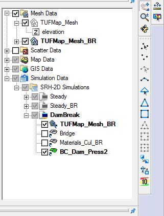
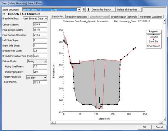
42 Case Study Tottenham Dam Break Flood Hazard Using SMS & SRH2D 42


43 Developing 2D Model using SMS 43
44 Developing 2D Model using SMS Free SRH-2D: US Bureau of Reclamation Software 2D depth-averaged dynamic wave equations Steady state or unsteady flows An implicit scheme stable model Mixed Structured and unstructured Grid Do Not Worry about Mesh Quality All flow regimes, i.e., Subcritical, Transcritical, and Supercritical Flows, may be simulated simultaneously without the need for special treatments Robust and seamless Wetting-Drying algorithm Hydraulic, Sediment Transport, Temperature & Vegetation. 44
45 SRH2D Hydraulic Structure Modeling 1D Bridge & Culvert 1D Weir Structure 1D Gate Control Structure 2D Bridge & Culvert 2D Pier & Obstruction Modeling 1D & 2D Pressure Flow for Bridge & Culvert 45


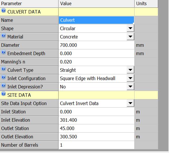
46 SRH2D : 1D Culvert using HY8 46


47 SRH2D : 1D Culvert using HY8 7m Long & 0.7m Dia Culvert 25m Long & 0.7m Dia Culvert 45m Long & 0.7m Dia Culvert 47
48 SRH2D : 2D Bridge Modeling Pressure Flow Free Surface Flow Drag Obstruction 48


49 SRH2D : 2D Bridge Modeling 49 Drag / Obstruction Pressure Flow Drag / Obstruction
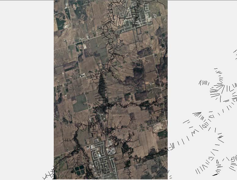
50 SRH2D : 2D Bridge Modeling 50


51 SRH2D : 2D Bridge Velocity Vector No Bridge Bridge with Pressure Bridge with Drag Bridge with Drag & Pressure 51
52 SRH2D : 2D Bridge Modeling 2D Momentum & Continuity Equations 2D Pier & Obstruction Modeling 2D Gridded Pressure Flow within Bridge & Culvert 52
53 Tottenham Dam Break 53

54 Tottenham Dam Break 54
55 Tottenham Dam Break Beeton Creek about 12 km Long Unsteady Model Timmins Storm Dam Break Hydrograph Peak flows for 10 inflow Tributaries Two 1D Culverts & Ten 2D Bridges Mixted Structured & Unstructured Grid 93,815 Elements 55

56 Tottenham Dam Break 56

57 Tottenham Dam Break 57


58 Tottenham Dam Break: Land Use 58

59 Tottenham Dam Break: Manning s n 59
60 Scatter 20m DEM data 60
61 Scatter Channel Breakline Data 61
62 Combined 20m DEM & Channel Breakline Data 62


63 Mesh with Combined Topo Data Interpolated Mesh Elevation 63
64 Tottenham Dam Break: Water Surface Elevation 9th Bee, e Lin ton 64
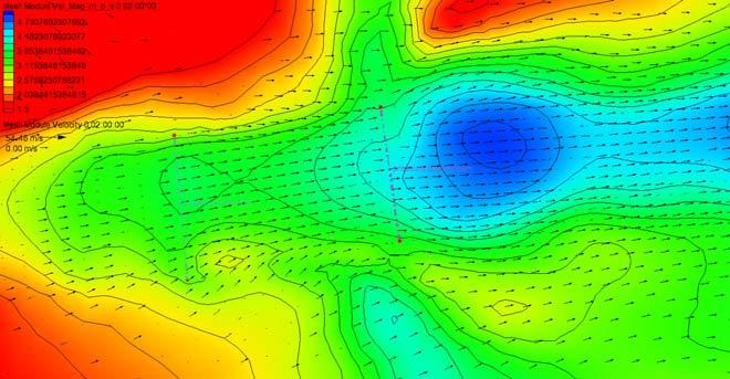
65 Tottenham Dam Break: Velocity 65 9th Line, Beeton
66 Tottenham Dam Break: Bed Shear Stress 9th Line, Beeton 66
67 Tottenham Dam Break: Froude Number 9th Line, Beeton 67
68 Tottenham Dam Break: Water Depth 9th Bee, e Lin ton 68
69 Tottenham Dam Break: Velocity X Depth 9th Line, Beeton 69
70 Cost of Hydraulic Modeling Free HEC-RAS + $10-15k ArcGIS + $150 / Hour + More Time Software Price + Software Maintenance + Technical Assistance + Time to Develop a Model $3.5k SMS $500 Maintenance $20-30k DHI + $10k Annual Fee + $150 / Hour + More Time 70
71 Benefits of using SMS 2D Model Cheap Software Because of its Private & Public Partnership Complete Software for Hydraulic, Flood Hazard & Mapping SMS is User Friendly 2D Modeling is Easier, Faster & Stable Hydraulic Modeller (HEC-RAS) can Learn it very Quickly Remove Misconception of 2D Modeling Difficulty Aquaveo Provide Technical Support ( ) We Provide Training & Technical Support 71

, P Eng")

72 Thank You! Contact: Dr. Bahar SM P.Geo.(Ltd), P Eng Phone: , bahar@ahydtech.ca
CHAPTER 7 FLOOD HYDRAULICS & HYDROLOGIC VIVEK VERMA
 CHAPTER 7 FLOOD HYDRAULICS & HYDROLOGIC VIVEK VERMA CONTENTS 1. Flow Classification 2. Chezy s and Manning Equation 3. Specific Energy 4. Surface Water Profiles 5. Hydraulic Jump 6. HEC-RAS 7. HEC-HMS
INTRODUCTION TO HEC-RAS
 INTRODUCTION TO HEC-RAS HEC- RAS stands for Hydrologic Engineering Center s River Analysis System By U.S. Army Corps of Engineers One dimensional analysis of : 1. Steady flow 2. Unsteady flow 3. Sediment
Introducion to Hydrologic Engineering Centers River Analysis System (HEC- RAS) Neena Isaac Scientist D CWPRS, Pune -24
 Neena Isaac Scientist D CWPRS, Pune -24") Introducion to Hydrologic Engineering Centers River Analysis System (HEC- RAS) Neena Isaac Scientist D CWPRS, Pune -24 One dimensional river models (1-D models) Assumptions Flow is one dimensional Streamline
Introducion to Hydrologic Engineering Centers River Analysis System (HEC- RAS) Neena Isaac Scientist D CWPRS, Pune -24 One dimensional river models (1-D models) Assumptions Flow is one dimensional Streamline
Prepared for CIVE 401 Hydraulic Engineering By Kennard Lai, Patrick Ndolo Goy & Dr. Pierre Julien Fall 2015
 Prepared for CIVE 401 Hydraulic Engineering By Kennard Lai, Patrick Ndolo Goy & Dr. Pierre Julien Fall 2015 Contents Introduction General Philosophy Overview of Capabilities Applications Computational
v SMS Tutorials SRH-2D Prerequisites Requirements SRH-2D Model Map Module Mesh Module Data files Time
 v. 11.2 SMS 11.2 Tutorial Objectives This tutorial shows how to build a Sedimentation and River Hydraulics Two-Dimensional () simulation using SMS version 11.2 or later. Prerequisites SMS Overview tutorial
HECRAS 2D: Are you ready for the revolution in the world of hydraulic modeling?
 HECRAS 2D: Are you ready for the revolution in the world of hydraulic modeling? Rishab Mahajan, Emily Campbell and Matt Bardol March 8, 2017 Outline Reasons for hydraulic modeling 1D Modeling 2D Modeling-
Day 1. HEC-RAS 1-D Training. Rob Keller and Mark Forest. Break (9:45 am to 10:00 am) Lunch (12:00 pm to 1:00 pm)
 Lunch (12:00 pm to 1:00 pm)") Day 1 HEC-RAS 1-D Training Rob Keller and Mark Forest Introductions and Course Objectives (8:00 am to 8:15 am) Introductions: Class and Content Module 1 Open Channel Hydraulics (8:15 am to 9:45 am) Lecture
Day 1 HEC-RAS 1-D Training Rob Keller and Mark Forest Introductions and Course Objectives (8:00 am to 8:15 am) Introductions: Class and Content Module 1 Open Channel Hydraulics (8:15 am to 9:45 am) Lecture
This tutorial shows how to build a Sedimentation and River Hydraulics Two-Dimensional (SRH-2D) simulation. Requirements
 simulation. Requirements") v. 13.0 SMS 13.0 Tutorial Objectives This tutorial shows how to build a Sedimentation and River Hydraulics Two-Dimensional () simulation. Prerequisites SMS Overview tutorial Requirements Model Map Module
v. 13.0 SMS 13.0 Tutorial Objectives This tutorial shows how to build a Sedimentation and River Hydraulics Two-Dimensional () simulation. Prerequisites SMS Overview tutorial Requirements Model Map Module
Overview of the Surface-water Modeling Software (SMS) GUI. Objective: This lecture will discuss the Surfacewater Modeling Software GUI.
 GUI. Objective: This lecture will discuss the Surfacewater Modeling Software GUI.") Overview of the Surface-water Modeling Software (SMS) GUI { Objective: This lecture will discuss the Surfacewater Modeling Software GUI. { Outline Outline Mesh Generation Interpolation Manning s n Coefficient
Overview of the Surface-water Modeling Software (SMS) GUI { Objective: This lecture will discuss the Surfacewater Modeling Software GUI. { Outline Outline Mesh Generation Interpolation Manning s n Coefficient
Objectives This tutorial shows how to build a Sedimentation and River Hydraulics Two-Dimensional (SRH-2D) simulation.
 simulation.") v. 12.1 SMS 12.1 Tutorial Objectives This tutorial shows how to build a Sedimentation and River Hydraulics Two-Dimensional () simulation. Prerequisites SMS Overview tutorial Requirements Model Map Module
v. 12.1 SMS 12.1 Tutorial Objectives This tutorial shows how to build a Sedimentation and River Hydraulics Two-Dimensional () simulation. Prerequisites SMS Overview tutorial Requirements Model Map Module
The HEC-RAS Model Refresher
 The HEC-RAS Model Refresher Minmin Shu P.E. Transportation Review Unit Water Resources Division Michigan Department of Environmental Quality 12-6-2018 What Does the HEC-RAS Mean RAS----River Analysis System
Objectives This tutorial will introduce how to prepare and run a basic ADH model using the SMS interface.
 v. 12.1 SMS 12.1 Tutorial Objectives This tutorial will introduce how to prepare and run a basic ADH model using the SMS interface. Prerequisites Overview Tutorial Requirements ADH Mesh Module Scatter
2014 AWRA Annual Water Resources Conference November 5, 2014 Tysons Corner, VA
 2014 AWRA Annual Water Resources Conference November 5, 2014 Tysons Corner, VA HEC-RAS Overview, History, & Future How HEC-RAS Works Model Development Standard FEMA Assumptions Building A Model FEMA Levels
2D Hydrodynamic Model for Reservoirs: Case Study High Aswan Dam Reservoir
 D Hydrodynamic Model for Reservoirs: Case Study High Aswan Dam Reservoir M. M. Soliman 1, M. A. Gad, Ashraf M. El-Moustafa 3 Abstract High Aswan Dam (HAD) is one of the most important projects in the history
Efficiency and Accuracy of Importing HEC RAS Datafiles into PCSWMM and SWMM5
 5 Efficiency and Accuracy of Importing HEC RAS Datafiles into PCSWMM and SWMM5 Karen Finney, Rob James, William James and Tiehong Xiao An advantage of USEPA s SWMM5 is its capability to dynamically model
George Mason University Department of Civil, Environmental and Infrastructure Engineering. Dr. Celso Ferreira
 George Mason University Department of Civil, Environmental and Infrastructure Engineering Dr. Celso Ferreira Exercise Topic: HEC GeoRAS Post-Processing Objectives: This tutorial is designed to walk you
Verification and Validation of HEC-RAS 5.1
 Verification and Validation of HEC-RAS 5.1 Gary Brunner 1, P.E., D. WRE, M.ASCE Dr. Alex Sanchez 1 Dr. Tom Molls 2 Dr. David Parr 3 1. USACE Hydrologic Engineering Center, Davis, CA 2. David Ford Consulting
HEC-RAS. A Tutorial (Model Development of a Small Flume)
") HEC-RAS A Tutorial (Model Development of a Small Flume) HEC-RAS Hydraulic Engineering Center:River Analysis System 1-D step backwater model Utilizes energy equation to compute water surface elevation for
HEC-RAS A Tutorial (Model Development of a Small Flume) HEC-RAS Hydraulic Engineering Center:River Analysis System 1-D step backwater model Utilizes energy equation to compute water surface elevation for
UNDERSTAND HOW TO SET UP AND RUN A HYDRAULIC MODEL IN HEC-RAS CREATE A FLOOD INUNDATION MAP IN ARCGIS.
 CE 412/512, Spring 2017 HW9: Introduction to HEC-RAS and Floodplain Mapping Due: end of class, print and hand in. HEC-RAS is a Hydrologic Modeling System that is designed to describe the physical properties
PRACTICAL UNIT 1 exercise task
 Practical Unit 1 1 1 PRACTICAL UNIT 1 exercise task Developing a hydraulic model with HEC RAS using schematic river geometry data In the course of practical unit 1 we prepare the input for the execution
WMS 9.0 Tutorial Hydraulics and Floodplain Modeling HEC-RAS Analysis Learn how to setup a basic HEC-RAS analysis using WMS
 v. 9.0 WMS 9.0 Tutorial Hydraulics and Floodplain Modeling HEC-RAS Analysis Learn how to setup a basic HEC-RAS analysis using WMS Objectives Learn how to build cross sections, stream centerlines, and bank
FLOODPLAIN MODELING USING HEC-RAS
 H A E S T A D M E T H O D S FLOODPLAIN MODELING USING HEC-RAS F i r s t E d i t i o n Authors Haestad Methods Gary Dyhouse Jennifer Hatchett Jeremy Benn Managing Editor Colleen Totz Editors David Klotz,
Prof. B.S. Thandaveswara. The computation of a flood wave resulting from a dam break basically involves two
 41.4 Routing The computation of a flood wave resulting from a dam break basically involves two problems, which may be considered jointly or seperately: 1. Determination of the outflow hydrograph from the
v SMS 11.1 Tutorial SRH-2D Prerequisites None Time minutes Requirements Map Module Mesh Module Scatter Module Generic Model SRH-2D
 v. 11.1 SMS 11.1 Tutorial SRH-2D Objectives This lesson will teach you how to prepare an unstructured mesh, run the SRH-2D numerical engine and view the results all within SMS. You will start by reading
This tutorial introduces the HEC-RAS model and how it can be used to generate files for use with the HEC-RAS software.
 v. 12.3 SMS 12.3 Tutorial Objectives This tutorial introduces the model and how it can be used to generate files for use with the software. Prerequisites Overview Tutorial Requirements 5.0 Mesh Module
2D Hydraulic Modeling, Steering Stream Restoration Design
 2D Hydraulic Modeling, Steering Stream Restoration Design PREPARED FOR: EcoStream 2018 Stream Ecology & Restoration Conference Presented By: Matthew D. Gramza, P.E., CFM, CPESC Civil & Environmental Consultants,
WMS 10.1 Tutorial Hydraulics and Floodplain Modeling HEC-RAS Analysis Learn how to setup a basic HEC-RAS analysis using WMS
 v. 10.1 WMS 10.1 Tutorial Hydraulics and Floodplain Modeling HEC-RAS Analysis Learn how to setup a basic HEC-RAS analysis using WMS Objectives Learn how to build cross sections, stream centerlines, and
Objectives This tutorial demonstrates how to perform unsteady sediment transport simulations in SRH-2D.
 SMS v. 12.2 SRH-2D Tutorial Objectives This tutorial demonstrates how to perform unsteady sediment transport simulations in SRH-2D. Prerequisites SMS Overview tutorial SRH-2D SRH-2D Sediment Transport
Urban Floodplain modeling- Application of Two-Dimensional Analyses to Refine Results
 Urban Floodplain modeling- Application of Two-Dimensional Analyses to Refine Results Prabharanjani Madduri, P.E., CFM Mathini Sreetharan, Ph.D., P.E., CFM Hydraulic modeling of urban areas and issues Modeling
Comparing HEC-RAS v5.0 2-D Results with Verification Datasets
 Comparing HEC-RAS v5.0 2-D Results with Verification Datasets Tom Molls 1, Gary Brunner 2, & Alejandro Sanchez 2 1. David Ford Consulting Engineers, Inc., Sacramento, CA 2. USACE Hydrologic Engineering
SMS v D Summary Table. SRH-2D Tutorial. Prerequisites. Requirements. Time. Objectives
 SMS v. 12.3 SRH-2D Tutorial Objectives Learn the process of making a summary table to compare the 2D hydraulic model results with 1D hydraulic model results. This tutorial introduces a method of presenting
SMS v Culvert Structures. SRH-2D Tutorial. Prerequisites. Requirements. Time. Objectives
 SMS v. 12.0 SRH-2D Tutorial Objectives This tutorial demonstrates the process of modeling culverts in SRH-2D. The Working with Simulations tutorial should have been completed before attempting this one.
v TUFLOW-2D Hydrodynamics SMS Tutorials Time minutes Prerequisites Overview Tutorial
 v. 12.2 SMS 12.2 Tutorial TUFLOW-2D Hydrodynamics Objectives This tutorial describes the generation of a TUFLOW project using the SMS interface. This project utilizes only the two dimensional flow calculation
Cross Sections, Profiles, and Rating Curves. Viewing Results From The River System Schematic. Viewing Data Contained in an HEC-DSS File
 C H A P T E R 9 Viewing Results After the model has finished the steady or unsteady flow computations the user can begin to view the output. Output is available in a graphical and tabular format. The current
Linear Routing: Floodrouting. HEC-RAS Introduction. Brays Bayou. Uniform Open Channel Flow. v = 1 n R2/3. S S.I. units
 Linear Routing: Floodrouting HEC-RAS Introduction Shirley Clark Penn State Harrisburg Robert Pitt University of Alabama April 26, 2004 Two (2) types of floodrouting of a hydrograph Linear Muskingum Reservoir
FLOODPLAIN MODELING MANUAL. HEC-RAS Procedures for HEC-2 Modelers
 FLOODPLAIN MODELING MANUAL HEC-RAS Procedures for HEC-2 Modelers Federal Emergency Management Agency Mitigation Directorate 500 C Street, SW Washington, DC 20472 April 2002 Floodplain Modeling Manual HEC-RAS
INTERNATIONAL JOURNAL OF CIVIL AND STRUCTURAL ENGINEERING Volume 2, No 3, 2012
 INTERNATIONAL JOURNAL OF CIVIL AND STRUCTURAL ENGINEERING Volume 2, No 3, 2012 Copyright 2010 All rights reserved Integrated Publishing services Research article ISSN 0976 4399 Efficiency and performances
Advanced 1D/2D Modeling Using HEC-RAS
 Advanced 1D/2D Modeling Using HEC-RAS Davis, California Objectives This is an advanced course in applying computer program HEC-RAS. The course provides participants with the knowledge to effectively use
Introduction to MIKE FLOOD
 Introduction to MIKE FLOOD HYDROEUROPE, Sophia-Antipolis, February 2011 Julie Landrein, DHI Denmark Introduction to MIKE FLOOD - Introduction to MIKE FLOOD - 1D Modelling: MIKE 11, MIKE URBAN - 2D Modelling:
HEC-RAS Verification and Validation Tests
 HEC-RAS Verification and Validation Tests April 2018 Approved for Public Release. Distribution Unlimited. RD-52 REPORT DOCUMENTATION PAGE Form Approved OMB No. 0704-0188 The public reporting burden for
Flood Inundation Mapping using HEC-RAS
 Flood Inundation Mapping using HEC-RAS Goodell, C. 1 ; Warren, C. 2 WEST Consultants, 2601 25 th St SE, Suite 450, Salem, OR 97302. Abstract Flood inundation mapping is an important tool for municipal
SRH-2D Additional Boundary Conditions
 v. 12.2 SMS 12.2 Tutorial SRH-2D Additional Boundary Conditions Objectives Learn techniques for using various additional boundary conditions with the Sedimentation and River Hydraulics Two-Dimensional
Appendix E. HEC-RAS and HEC-Ecosystem Functions Models
 Appendix E HEC-RAS and HEC-Ecosystem Functions Models 1 Appendix E: Modeled Reaches for the Connecticut River Watershed application of HEC-RAS Separate from the report for the Decision Support System of
COMPARISON OF NUMERICAL HYDRAULIC MODELS APPLIED TO THE REMOVAL OF SAVAGE RAPIDS DAM NEAR GRANTS PASS, OREGON
 COMPARISON OF NUMERICAL HYDRAULIC MODELS APPLIED TO THE REMOVAL OF SAVAGE RAPIDS DAM NEAR GRANTS PASS, OREGON Jennifer Bountry, Hydraulic Engineer, Bureau of Reclamation, Denver, CO, jbountry@do.usbr.gov;
SMS v Culvert Structures with HY-8. Prerequisites. Requirements. Time. Objectives
 SMS v. 12.1 SRH-2D Tutorial Culvert Structures with HY-8 Objectives This tutorial demonstrates the process of modeling culverts in SRH-2D coupled with the Federal Highway Administrations HY-8 culvert analysis
Updated on November 10, 2017
 CIVE 7397 Unsteady flows in Rivers and Pipe Networks/Stormwater Management and Modeling / Optimization in Water Resources Engineering Updated on November 10, 2017 Tutorial on using HEC-GeoRAS 10.1 (or
Numerical Hydraulics
 ETHZ, Fall 2017 Numerical Hydraulics Assignment 3 Comparison of two numerical solutions of river flow: use of Finite Elements (HEC-RAS) and Finite Volumes (BASEMENT) 1 Introduction In the course, two different
Watershed Analysis with the Hydrologic Engineering Center s River Analysis System (HEC-RAS)
") Watershed Analysis with the Hydrologic Engineering Center s River Analysis System (HEC-RAS) by Christopher R. Goodell and Gary W. Brunner PURPOSE: The objectives of this document are to provide a general
Watershed Analysis with the Hydrologic Engineering Center s River Analysis System (HEC-RAS) by Christopher R. Goodell and Gary W. Brunner PURPOSE: The objectives of this document are to provide a general
HEC-RAS 3.0 January, 2001 Release Notes
 HEC-RAS 3.0 January, 2001 Release Notes A new version of HEC-RAS (3.0) has been released with significant new features over the previous version (2.21). Version 3.0 includes unsteady flow routing capabilities,
v Data Visualization SMS 12.3 Tutorial Prerequisites Requirements Time Objectives Learn how to import, manipulate, and view solution data.
 v. 12.3 SMS 12.3 Tutorial Objectives Learn how to import, manipulate, and view solution data. Prerequisites None Requirements GIS Module Map Module Time 30 60 minutes Page 1 of 16 Aquaveo 2017 1 Introduction...
ISIS 1D. Quick Start Guide. Cost effective, integrated software solutions ch2mhill.com/isis
 ISIS 1D Quick Start Guide Cost effective, integrated software solutions 0845 094 7990 ch2mhill.com/isis softwaresupport@ch2m.com Table of Contents Overview... 3 1. Starting ISIS and Basic Concepts... 3
Classwork 5 Using HEC-RAS for computing water surface profiles
 Classwork 5 Using HEC-RAS for computing water surface profiles (in collaboration with Dr. Ing. Luca Milanesi) Why classwork 5? This lecture will give us the possibility to make our first acquaintance with
Automating Hydraulic Analysis v 1.0.
 2011 Automating Hydraulic Analysis v 1.0. Basic tutorial and introduction Automating Hydraulic Analysis (AHYDRA) is a freeware application that automates some specific features of HEC RAS or other hydraulic
Overview of the SMS Interface for the CMS and New CIRP Additions: CIRP Wiki and CMS Discussion List
 Overview of the SMS Interface for the CMS and New Additions: Wiki and CMS Discussion List Mitch Brown Coastal and Hydraulics Laboratory Engineer Research and Development Center May 20, 2010 US Army Corps
Hydrodynamic Modeling for Ex-Situ Testing
 Geo-Hydro-RU0781 Hydrodynamic Modeling for Ex-Situ Testing Final Report March 2011 Submitted by Joseph Ruggeri, P.E., CFM Geo-Hydro Inc. 22 Christinalynn Drive Monroe, NJ 08831 In cooperation with Geo-Hydro,
Connecting 1D and 2D Domains
 Connecting 1D and 2D Domains XP Solutions has a long history of Providing original, high-performing software solutions Leading the industry in customer service and support Educating our customers to be
A Comparative Study of HEC-RAS 2D, TUFLOW, & Mike 21 Model Benchmark Testing
 A Comparative Study of HEC-RAS 2D, TUFLOW, & Mike 21 Model Benchmark Testing June 2016 Presented by: Murari Paudel, PhD, PE, CFM Soledad B Roman, EIT John Prichard, PE, CFM Wood Rodgers Inc. Sacramento,
2D Large Scale Automated Engineering for FEMA Floodplain Development in South Dakota. Eli Gruber, PE Brooke Conner, PE
 2D Large Scale Automated Engineering for FEMA Floodplain Development in South Dakota Eli Gruber, PE Brooke Conner, PE Project Acknowledgments FEMA Region 8 Staff: Brooke Conner, PE Casey Zuzak, GISP Ryan
Comparing 2D Approaches for Complex FEMA Studies
 Comparing 2D Approaches for Complex FEMA Studies Presented by: Ted Cassidy, P.E., PH (STARR2-Dewberry) Sam Crampton, P.E., CFM (STARR2-Dewberry) Mike DePue, P.E., CFM (STARR2-Atkins) Agenda Introduction
River Analysis System HEC-RAS
 Hydrologic Engineering Center River Analysis System HEC-RAS Release Notes Version 4.0.0 March 2008 Approved for Public Release Distribution Unlimited 1 Introduction Version 4.0.0 of the River Analysis
Steady Flow Water Surface Profile Computation Using HEC-RAS
 Steady Flow Water Surface Profile Computation Using HEC-RAS Objectives The objective of the course is to enable the participants to perform water surface profile computations using computer program HEC-RAS
Using HEC-RAS and HEC-GeoRAS for River Modeling Adapted by E. Maurer, using an exercise by V. Merwade, Purdue Univ.
 Introduction Using HEC-RAS and HEC-GeoRAS for River Modeling Adapted by E. Maurer, using an exercise by V. Merwade, Purdue Univ. This tutorial uses the output from HEC_GeoRAS from a prior exercise as input
HCFCD Review Process
 HCFCD Review Process Impact Analysis Local Review LOMR Delegation Local Review This presentation will include: Why is this step important? Process Review Checklist Common Comments 2 Local Review Why is
v TUFLOW 1D/2D SMS 11.2 Tutorial Time minutes Prerequisites TUFLOW 2D Tutorial
 v. 11.2 SMS 11.2 Tutorial Objectives This tutorial describes the generation of a 1D TUFLOW project using the SMS interface. It is strongly recommended that the TUFLOW 2D tutorial be completed before doing
Flood Routing for Continuous Simulation Models
 Improving Life through Science and Technology Flood Routing for Continuous Simulation Models J. Williams, W. Merkel, J. Arnold, J. Jeong 11 International SWAT Conference, Toledo, Spain, June 15-17, 11
Cloud-Computing Based Real-Time Flood Simulation (RealFlood Engine)
") Cloud-Computing Based Real-Time Flood Simulation (RealFlood Engine) Jennifer G Duan, PhD., PE Principal, KKC Engineering (UA Tech Launch) Associate Professor Delbert R. Lewis Distinguished Professor Civil
Cloud-Computing Based Real-Time Flood Simulation (RealFlood Engine) Jennifer G Duan, PhD., PE Principal, KKC Engineering (UA Tech Launch) Associate Professor Delbert R. Lewis Distinguished Professor Civil
v SRH-2D Post-Processing SMS 12.3 Tutorial Prerequisites Requirements Time Objectives
 v. 12.3 SMS 12.3 Tutorial SRH-2D Post-Processing Objectives This tutorial illustrates some techniques for manipulating the solution generated by the Sedimentation and River Hydraulics Two-Dimensional (SRH-2D)
Solving non-hydrostatic Navier-Stokes equations with a free surface
 Solving non-hydrostatic Navier-Stokes equations with a free surface J.-M. Hervouet Laboratoire National d'hydraulique et Environnement, Electricite' De France, Research & Development Division, France.
HEC-RAS River Analysis System
 HEC-RAS River Analysis System Supplemental to HEC-RAS Version 5.0 User's Manual Version 5.0.4 April 2018 Approved for Public Release. Distribution Unlimited. CPD-68d REPORT DOCUMENTATION PAGE Form Approved
Harris County Flood Control District HEC-RAS 2D Modeling Guidelines (Standardizing HEC-RAS 2D Models for Submittal Within Harris County)
") Harris County Flood Control District HEC-RAS 2D Modeling Guidelines (Standardizing HEC-RAS 2D Models for Submittal Within Harris County) Presented by: April 27, 2017 Matthew Zeve, P.E., CFM Harris County
Harris County Flood Control District HEC-RAS 2D Modeling Guidelines (Standardizing HEC-RAS 2D Models for Submittal Within Harris County) Presented by: April 27, 2017 Matthew Zeve, P.E., CFM Harris County
v TUFLOW FV SMS 12.2 Tutorial Time Requirements Prerequisites Objectives
 SMS 12.2 Tutorial v. 12.2 Objectives is an engine for performing 2D and 3D hydrodynamic simulations. The model solves the Non-linear Shallow Water Equations (NLSWE) on a flexible mesh using a finite-volume
TUFLOW. Flood & Coastal Simulation Software. tuflow.com
 TUFLOW Flood & Coastal Simulation Software tuflow.com 2 Accurate, efficient numerical engines for application to urban drainage, floodplains, estuaries, coastlines and beyond Contents E 4: ngines M 10:
Free surface algorithms for 3D numerical modelling of reservoir flushing
 River Flow 2010 - Dittrich, Koll, Aberle & Geisenhainer (eds) - 2010 Bundesanstalt für Wasserbau ISBN 978-3-939230-00-7 Free surface algorithms for 3D numerical modelling of reservoir flushing Nils Reidar
Data Visualization SURFACE WATER MODELING SYSTEM. 1 Introduction. 2 Data sets. 3 Open the Geometry and Solution Files
 SURFACE WATER MODELING SYSTEM Data Visualization 1 Introduction It is useful to view the geospatial data utilized as input and generated as solutions in the process of numerical analysis. It is also helpful
2D MODELING. Overview of 2D Modeling
 Overview of 2D Modeling No one believes a model, except the person who wrote it; Everyone believes data, except the person who collected it. unknown wise scientist Two dimensional (depth averaged) hydrodynamic
v Cartesian Grid Generation SMS 12.3 Tutorial Prerequisites Requirements Time Objectives
 v. 12.3 SMS 12.3 Tutorial Objectives This tutorial gives a brief introduction to generating a Cartesian Grid in SMS. Prerequisites Overview Tutorial Map Module Tutorial Requirements Map Module Cartesian
Watershed Modeling HEC-HMS Interface
 v. 10.1 WMS 10.1 Tutorial Learn how to set up a basic HEC-HMS model using WMS Objectives Build a basic HEC-HMS model from scratch using a DEM, land use, and soil data. Compute the geometric and hydrologic
TUFLOW 1D/2D SURFACE WATER MODELING SYSTEM. 1 Introduction. 2 Background Data
 SURFACE WATER MODELING SYSTEM TUFLOW 1D/2D 1 Introduction This tutorial describes the generation of a 1D TUFLOW project using the SMS interface. It is recommended that the TUFLOW 2D tutorial be done before
WMS 9.1 Tutorial Hydraulics and Floodplain Modeling Floodplain Delineation Learn how to us the WMS floodplain delineation tools
 v. 9.1 WMS 9.1 Tutorial Hydraulics and Floodplain Modeling Floodplain Delineation Learn how to us the WMS floodplain delineation tools Objectives Experiment with the various floodplain delineation options
v SMS 11.1 Tutorial Data Visualization Requirements Map Module Mesh Module Time minutes Prerequisites None Objectives
 v. 11.1 SMS 11.1 Tutorial Data Visualization Objectives It is useful to view the geospatial data utilized as input and generated as solutions in the process of numerical analysis. It is also helpful to
Module 9. Lecture 3: Major hydrologic models-hspf, HEC and MIKE
 Lecture 3: Major hydrologic models-hspf, HEC and MIKE Major Hydrologic Models HSPF (SWM) HEC MIKE Hydrological Simulation Program-Fortran (HSPF) Commercial successor of the Stanford Watershed Model (SWM-IV)
Layout of Presentation
 Specialized Training Course On Modelling For River Engineering Applications On : SSIIM Program (25th -29th September, 2011), Egypt By : Dr: Ahmed Musa Siyam Eng: Elnazir Saad Ali Layout of Presentation
HEC-RAS River Analysis System
 HEC-RAS River Analysis System Version 5.0.7 March 2019 Approved for Public Release. Distribution Unlimited. Introduction Version 5.0.7 of the River Analysis System (HEC-RAS) is now available. This Version
River Analysis System HEC-RAS
 Hydrologic Engineering Center River Analysis System HEC-RAS Release Notes Version 5.0.2 August 2016 Approved for Public Release Distribution Unlimited 1 Introduction Version 5.0.2 of the River Analysis
Use of measured and interpolated crosssections
 Use of measured and interpolated crosssections in hydraulic river modelling Y. Chen/, R. Crowded & R. A. Falconer^ ^ Department of Civil & Environmental Engineering, University ofbradford, Bradford, West
SMS v Simulations. SRH-2D Tutorial. Time. Requirements. Prerequisites. Objectives
 SMS v. 12.1 SRH-2D Tutorial Objectives This tutorial will demonstrate the process of creating a new SRH-2D simulation from an existing simulation. This workflow is very useful when adding new features
ISIS Free & ISIS Professional Quick Start Guide
 ISIS Free & ISIS Professional Cost effective, integrated modelling solutions Think saving, think ISIS, think Halcrow This quick start guide enables first time users to quickly understand how to use ISIS
v TUFLOW FV SMS 13.0 Tutorial Requirements Time Prerequisites Objectives
 v. 13.0 SMS 13.0 Tutorial Objectives This tutorial demonstrates creating a simple model of a short section of river using the SMS TUFLOW FV interface. A mesh for an inbank area of a river will be built,
Overview of the SMS (v11.0)
") Overview of the SMS (v11.0) Mitchell Brown Civil Engineering Technician Mitchell.E.Brown@erdc.dren.mil June 11-15, 2012 CMS Shark River Inlet, NJ CPT Grays Harbor, WA Wood Wood chips Flour Other US Army
Overview of the SMS (v11.0) Mitchell Brown Civil Engineering Technician Mitchell.E.Brown@erdc.dren.mil June 11-15, 2012 CMS Shark River Inlet, NJ CPT Grays Harbor, WA Wood Wood chips Flour Other US Army
TUFLOW Two & one-dimensional Unsteady FLOW Software for Rivers, Estuaries and Coastal Waters
 TUFLOW Two & one-dimensional Unsteady FLOW Software for Rivers, Estuaries and Coastal Waters W.J.Syme B.E.(Hons), M.Eng.Sc.(Res) - WBM Oceanics Australia Summary: Once limited to coastal hydraulics, two-dimensional
Open Channel Flow. Course paper: Water level calculation with HEC-RAS
 Course paper: Water level calculation with HEC-RAS Prof. Dr.-Ing. Tobias Bleninger Graduate Program for Water Resources and Environmental Engineering (PPGERHA) Universidade Federal do Paraná - UFPR Centro
2-D Hydraulic Modeling Theory & Practice
 2-D Hydraulic Modeling Theory & Practice Author: Maged A. Aboelata, PhD, PE, CFM Presenter: Heather Zhao, PE, CFM October 2017 Presentation Outline * 1-D vs. 2-D modeling * Theory of 2-D simulation * Commonly
MIKE 21 Flow Model FM. Sand Transport Module. Step-by-step training guide: Coastal application
 MIKE 21 Flow Model FM Sand Transport Module Step-by-step training guide: Coastal application MIKE 2017 DHI headquarters Agern Allé 5 DK-2970 Hørsholm Denmark +45 4516 9200 Telephone +45 4516 9333 Support
Application of 2-D Modelling for Muda River Using CCHE2D
 Application of 2-D Modelling for Muda River Using CCHE2D ZORKEFLEE ABU HASAN, Lecturer, River Engineering and Urban Drainage Research Centre (REDAC), Universiti Sains Malaysia, Engineering Campus, Seri
SMS v SRH-2D Tutorials Obstructions. Prerequisites. Requirements. Time. Objectives
 SMS v. 12.3 SRH-2D Tutorials Obstructions Objectives This tutorial demonstrates the process of creating and defining in-stream obstructions within an SRH-2D model. The SRH-2D Simulations tutorial should
Hydraulic Modeling with HEC RAS. Susan Cundiff, PE December 4, 2017
 Hydraulic Modeling with HEC RAS Susan Cundiff, PE December 4, 2017 Overview Introduction to HEC RAS Computational Procedures Building a Model Example Projects Introduction to HEC RAS U.S. Army Corps of
Using 2D Schemes to Model Energy Losses at Structures and Bends Beware of Pretty Images!
 Using 2D Schemes to Model Energy Losses at Structures and Bends Beware of Pretty Images! Bill Syme BMT WBM Software Business Manager 2D: Looks impressive, but is it accurate? 2 Form Losses Energy dissipated
WMS 10.0 Tutorial Hydraulics and Floodplain Modeling HY-8 Modeling Wizard Learn how to model a culvert using HY-8 and WMS
 v. 10.0 WMS 10.0 Tutorial Hydraulics and Floodplain Modeling HY-8 Modeling Wizard Learn how to model a culvert using HY-8 and WMS Objectives Define a conceptual schematic of the roadway, invert, and downstream
P Two-dimensional Modelling of Dam Breach Flooding. Miguel Ángel Corcuera Barrera 1, Peter Torp Larsen 2, Poul Kronborg 2
 Two-dimensional Modelling of Dam Breach Flooding. Miguel Ángel Corcuera Barrera 1, Peter Torp Larsen 2, Poul Kronborg 2 1 Aguas del Añarbe, España 2 DHI Spain Presenter: Peter Torp Larsen, ptl@dhigroup.com
Hydraulics and Floodplain Modeling Modeling with the Hydraulic Toolbox
 v. 9.1 WMS 9.1 Tutorial Hydraulics and Floodplain Modeling Modeling with the Hydraulic Toolbox Learn how to design inlet grates, detention basins, channels, and riprap using the FHWA Hydraulic Toolbox