UNDERSTAND HOW TO SET UP AND RUN A HYDRAULIC MODEL IN HEC-RAS CREATE A FLOOD INUNDATION MAP IN ARCGIS.
|
|
|
- Marilynn Webster
- 6 years ago
- Views:
Transcription


1 CE 412/512, Spring 2017 HW9: Introduction to HEC-RAS and Floodplain Mapping Due: end of class, print and hand in. HEC-RAS is a Hydrologic Modeling System that is designed to describe the physical properties of streams and rivers, and to route flows through them. Given the discharge computed by HEC-HMS or by other means, HEC-RAS computes the resulting water surface elevation. Using a program HEC-GeoRAS, these elevations can be mapped in ArcGIS to form a flood inundation map. In this exercise, you will run a HEC- RAS model for a particular location on Brushy Creek and use ArcGIS to create the corresponding floodplain map. AFTER COMPLETING THIS EXERCISE, YOU WILL BE ABLE TO UNDERSTAND HOW TO SET UP AND RUN A HYDRAULIC MODEL IN HEC-RAS CREATE A FLOOD INUNDATION MAP IN ARCGIS. Copy data from (drive W:) and place on the C drive under the temp folder(c:\temp\). Do not place in your User folder. Copy data above it. Open HEC-RAS. 2. Open existing HEC-RAS Model To open an existing HEC-RAS model, click on RAS File -> Open Project and navigate to the UB100yr2.prj file. This is a file for a HEC-RAS model for the confluence of Brushy Creek and South Brushy Creek at Walsh Drive.


2 Hit OK to load the project. HEC-RAS contains a series of Elements, and in this project, let s start with the Geometric Data. From Edit menu, select Geometric Data.
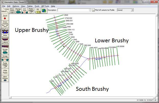
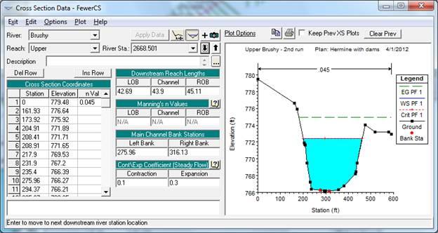
3 Open the Cross-Section Editor

4 By using the Up and Down arrows you can navigate along the river cross-sections. By changing the Reach you can switch from Upper to Lower Brushy Creek. By changing the River you can switch from Brushy Creek to South Brushy Creek. Examine the cross-sections in the model. The River Station gives the distance in feet from the most downstream end of the River. In this case feet is the distance from this cross-section on Brushy Creek to the most downstream point on this creek shown in this model. To be turned in: Determine the distance in feet from the upper most to the lower most cross-section on Brushy Creek (Upper Brushy to Lower Brushy Creek, not including South Brushy Creek). How many cross-sections are there in this distance? What is the average distance between the cross-sections? Repeat this calculation for South Brushy Creek. Describe in words the cross-section at Station on Brushy Creek: a). What value of Manning s n is used? b). What is the distance to the next downstream cross-section (ft) for the Left Overbank, Channel and Right Overbank flows? c). What is the lowest elevation of the stream bed (ft above datum)? d). What is the highest elevation of a point in the crosssection? e).what is the horizontal length of the cross-section (ft)? Close the Geometric Data window. Now, let s review the steady flow data. From Edit menu, select Steady Flow Data.
.")
5 These flows are approximated values taken from the HEC-HMS model for the flows during Tropical Storm Hermine on Upper Brushy Creek. The Lower Reach has the total flow of 18,800 cfs, which is divided into 16,300 cfs for the Upper Reach of Brushy Creek and 2500 cfs for the South Brushy Creek (the flow that comes from Dam 7). If you click on the box that says Reach Boundary Conditions you ll see a display like that shown below. What this means is that at the downstream end of the lower reach, the Boundary Condition is set at the Normal Depth for a bed slope of The other two reaches have their downstream boundary condition for depth equal to the upstream depth of the Lower Reach of the main Brushy River. Close the Steady Flow Data window. 3. Run Steady State Model Frim HEC=RAS Run menu select Steady Flow Analysis The Steady Flow Analysis form shows.

 on HEC-RAS interface.")
6 Click on Compute. The model will run. Close the run and Steady Flow Analysis forms. Click on View profiles button ( stream sections. ) on HEC-RAS interface. Review longitudinal profiles for the three
 on HEC-RAS interface.")
7 Click on View cross sections button ( surface elevations at cross-sections. ) on HEC-RAS interface. Review cross-sections and water
 on HEC-RAS interface.")
8 Click on View 3D multiple cross section plot button ( and water surface elevations at cross-sections. ) on HEC-RAS interface. Review cross-sections
 on HEC-RAS interface. Review results.")
9 Click on View summary output tables by profile button ( ) on HEC-RAS interface. Review results.


10 Change the Profile Plot and then open the Summary Output Table for the new profile to get the three tables describing the water surface profile in the three reaches. To be Turned in: Calculate the average velocity over all cross-sections in each of the three reaches (ft/sec). Using these data and the plots of the water surface profiles, describe what is controlling the water surface elevation in South Brushy Creek for the reach we have analyzed. 4. Export results to GIS format From HEC-RAS File menu select Export GIS Data.


11 Populate the form and export the data. And you ll see that this file has been created:

12 Open ArcGIS and in Customize Toolbars, select the HEC-GeoRAS option. Save the ArcMap document as BrushyCreek.mxd Here is what the ArcGIS display looks like with the HEC-GeoRAS extension loaded:


13 You need to have the Spatial Analyst and 3D Analyst extensions of ArcGIS to run this tool. You can check whether you have these extensions by using Customize/Extensions 5. Generate floodplain in GIS Open an existing ArcMap GeoRAS project (use icon shown on next line). Make sure GeoRAS toolbar is active. Save the project. Click on Import RAS SDF File button ( ) from GeoRAS toolbar (this step converts the sdf file into an XML formatted file it does not actually import the data).

. iii. Which terrain dataset to use (ubcaoi).. iv. Output directory..v. Rasterization cell (accept default).")
14 Select the sdf file created in previous step (this is of RAS Export type). Note the name of the output file (same as the input file but with xml extension). Click on OK to perform the format conversion. Don t worry about an error message saying that this XML file already exists. Define the new import project by running Layer Setup (from RAS Mapping menu on the GeoRAS toolbar). Define:..i. Name of the new analysis (HermineDam)..ii. Name of the RAS GIS export file (UB100yr2.RASexport.XML). iii. Which terrain dataset to use (ubcaoi).. iv. Output directory..v. Rasterization cell (accept default). vi. The completed form should look like the following figure.
. Save the project.")
15 Click on OK. A new data frame will be created with the name matching the name of the analysis, with the specified terrain dataset loaded in it. The actual import of the data has not been performed yet. (The terrain is turned off by default, so the new data frame will appear empty). Save the project. Import GIS data (RAS Mapping -> Import RAS Data). The process might take few minutes depending on the complexity of the results. During the process, several informative messages will be displayed in the form. Wait until it give message import was successful.

16 GIS representation of the BankPoints, Velocities, Water Surface Extent, River2D centerline, XS Cut Lines (these are the lines that were cut on the Digital Elevation Model to get the original cross-sections, the Bounding Polygon around the dataset. Explore the created dataset.

17 If you turn on only the DEM, ubcaoi, here is what you will see. UBCAOI stands for Upper Brushy Channel Area of Inundation.
.")

18 Create water surface TIN (water surface bound only by the extent of the bounding polygon) by running Water Surface Generation function (from RAS Mapping -> Inundation Mapping menu). TIN stands for Triangulated Irregular Network, which is another way that GIS uses to form surfaces by connecting points and lines into triangles. a. Select the profile for which to create the water surface TIN. In our case there will be just one profile (PF1). b. Check Draw Output Layers if you want to display the TIN (you might not want to do that if you select many profiles to generate at one time).
. a. Select one or several profiles for which to create the floodplain extent (depth grid will be created automatically).")

19 c. Select other options for smoothing and merging floodplain polygons (normally, keep these options unchecked). Here is the resulting TIN. Generate floodplain and water depth (by running RAS Mapping -> Inundation Mapping -> Floodplain Delineation Using Rasters function). a. Select one or several profiles for which to create the floodplain extent (depth grid will be created automatically). Only those profiles processed in step one will be available for processing. b. Check Draw Output Layers if you want to display the output layers. c. Check Smooth Floodplain Delineation if you want to smooth the output floodplain polygon (but you should not do that in the initially). d. For each selected profile, a depth grid and a floodplain polygon feature class will be created. And the following result appears!! What is happening here is that the TIN of the water surface is converted to a grid, and then the grid of the land surface elevation is subtracted from it to form the grid of the water depths shown below.

20 Review the results. Relate the floodplain shape and behavior to the assumptions of 1-D flow in RAS. Pay special attention to the following: a. Where floodplain polygon extends all the way to the bounding polygon. This might indicate locations where cross-sections were not defined wide enough. b. Where there is a break in floodplain polygon. This might indicate that cross-sections were not placed close enough. c. Where there are isolated flooded areas (either on the cross-section or not). This might indicate isolated areas that should not be included as the flow contributing areas. d. Where there are flares in the floodplain. e. Where flow path lines (used to determine distances between cross-sections) are not within the floodplain. f. If water surface extent points are not on the floodplain boundary. g. Other unusual floodplain features. If you use the Identify tool on the layer d PF 1, you can check values of the grid of the water depth.


21 To provide some perspective of the background to this analysis, let s add a Basemap: Choose the option for Imagery And you ll get a rather nice display of the floodplain drawn over a map of Brushy Creek near Walsh Dr.

22 If you turn on the XS Cut Lines and zoom in you can see a rather nice map of the floodplain and the cross-sections used to create it in the neighborhood of the homes we visited when we were on our field trip earlier this semester. Pretty cool!
.")
23 To be turned in: A snippet showing the floodplain of Brushy Creek in the area of Walsh Drive. May need to add map with street names. Summary of items to be turned in: 1. Determine the distance in feet from the upper most to the lower most cross-section on Brushy Creek (Upper Brushy to Lower Brushy Creek, not including South Brushy Creek). How many cross-sections are there in this distance? What is the average distance between the cross-sections? Repeat this calculation for South Brushy Creek. Describe in words the cross-section at Station on Brushy Creek: a). What value of Manning s n is used? b). what is the distance to the next downstream cross-section (ft) for the Left Overbank, Channel and Right Overbank flows? c). what is the lowest elevation of the stream bed (ft. above datum)? d). what is the highest elevation of a point in the cross-section? e).what is the horizontal length of the cross-section (ft.) 2. Calculate the average velocity over all cross-sections in each of the three reaches (ft/sec). Using these data and the plots of the water surface profiles, describe what is controlling the water surface elevation in South Brushy Creek for the reach we have analyzed. 3. A map showing the floodplain of Brushy Creek in the area of Walsh Dr. Print and hand in. Ok, you re done!
24
George Mason University Department of Civil, Environmental and Infrastructure Engineering. Dr. Celso Ferreira
 George Mason University Department of Civil, Environmental and Infrastructure Engineering Dr. Celso Ferreira Exercise Topic: HEC GeoRAS Post-Processing Objectives: This tutorial is designed to walk you
Using HEC-RAS and HEC-GeoRAS for River Modeling Adapted by E. Maurer, using an exercise by V. Merwade, Purdue Univ.
 Introduction Using HEC-RAS and HEC-GeoRAS for River Modeling Adapted by E. Maurer, using an exercise by V. Merwade, Purdue Univ. This tutorial uses the output from HEC_GeoRAS from a prior exercise as input
WMS 9.0 Tutorial Hydraulics and Floodplain Modeling HEC-RAS Analysis Learn how to setup a basic HEC-RAS analysis using WMS
 v. 9.0 WMS 9.0 Tutorial Hydraulics and Floodplain Modeling HEC-RAS Analysis Learn how to setup a basic HEC-RAS analysis using WMS Objectives Learn how to build cross sections, stream centerlines, and bank
WMS 10.1 Tutorial Hydraulics and Floodplain Modeling HEC-RAS Analysis Learn how to setup a basic HEC-RAS analysis using WMS
 v. 10.1 WMS 10.1 Tutorial Hydraulics and Floodplain Modeling HEC-RAS Analysis Learn how to setup a basic HEC-RAS analysis using WMS Objectives Learn how to build cross sections, stream centerlines, and
Floodplain Mapping & Hydraulic Analysis with HEC-GeoRAS and ArcGIS 9.1
 Floodplain Mapping & Hydraulic Analysis with HEC-GeoRAS 4.1.1 and ArcGIS 9.1 Prepared by Sarah Meyer 1 and Francisco Olivera 2, Ph.D., P.E. May 2007 Contents: 1. Goals of Exercise & Additional Resources
Updated on November 10, 2017
 CIVE 7397 Unsteady flows in Rivers and Pipe Networks/Stormwater Management and Modeling / Optimization in Water Resources Engineering Updated on November 10, 2017 Tutorial on using HEC-GeoRAS 10.1 (or
George Mason University Department of Civil, Environmental and Infrastructure Engineering. Dr. Celso Ferreira Prepared by Lora Baumgartner
 George Mason University Department of Civil, Environmental and Infrastructure Engineering Dr. Celso Ferreira Prepared by Lora Baumgartner Exercise Topic: Getting started with HEC GeoRAS Objective: Create
WMS 9.1 Tutorial Hydraulics and Floodplain Modeling Floodplain Delineation Learn how to us the WMS floodplain delineation tools
 v. 9.1 WMS 9.1 Tutorial Hydraulics and Floodplain Modeling Floodplain Delineation Learn how to us the WMS floodplain delineation tools Objectives Experiment with the various floodplain delineation options
Tutorial on using HEC-GeoRAS with ArcGIS 9.3
 Introduction Tutorial on using HEC-GeoRAS with ArcGIS 9.3 Prepared by Venkatesh Merwade School of Civil Engineering, Purdue University vmerwade@purdue.edu November 2009 This tutorial is designed to expose
WMS 10.0 Tutorial Hydraulics and Floodplain Modeling HY-8 Modeling Wizard Learn how to model a culvert using HY-8 and WMS
 v. 10.0 WMS 10.0 Tutorial Hydraulics and Floodplain Modeling HY-8 Modeling Wizard Learn how to model a culvert using HY-8 and WMS Objectives Define a conceptual schematic of the roadway, invert, and downstream
SMS v D Summary Table. SRH-2D Tutorial. Prerequisites. Requirements. Time. Objectives
 SMS v. 12.3 SRH-2D Tutorial Objectives Learn the process of making a summary table to compare the 2D hydraulic model results with 1D hydraulic model results. This tutorial introduces a method of presenting
Appendix E. HEC-RAS and HEC-Ecosystem Functions Models
 Appendix E HEC-RAS and HEC-Ecosystem Functions Models 1 Appendix E: Modeled Reaches for the Connecticut River Watershed application of HEC-RAS Separate from the report for the Decision Support System of
PRACTICAL UNIT 1 exercise task
 Practical Unit 1 1 1 PRACTICAL UNIT 1 exercise task Developing a hydraulic model with HEC RAS using schematic river geometry data In the course of practical unit 1 we prepare the input for the execution
HEC-GeoRAS GIS Tools for Support of HEC-RAS using ArcGIS
 US Army Corps of Engineers Hydrologic Engineering Center HEC-GeoRAS GIS Tools for Support of HEC-RAS using ArcGIS User's Manual Version 4.2 September 2009 Approved for Public Release. Distribution Unlimited.
WMS 10.1 Tutorial Hydraulics and Floodplain Modeling Simplified Dam Break Learn how to run a dam break simulation and delineate its floodplain
 v. 10.1 WMS 10.1 Tutorial Hydraulics and Floodplain Modeling Simplified Dam Break Learn how to run a dam break simulation and delineate its floodplain Objectives Setup a conceptual model of stream centerlines
Introduction to GIS 2011
 Introduction to GIS 2011 Digital Elevation Models CREATING A TIN SURFACE FROM CONTOUR LINES 1. Start ArcCatalog from either Desktop or Start Menu. 2. In ArcCatalog, create a new folder dem under your c:\introgis_2011
Linear Routing: Floodrouting. HEC-RAS Introduction. Brays Bayou. Uniform Open Channel Flow. v = 1 n R2/3. S S.I. units
 Linear Routing: Floodrouting HEC-RAS Introduction Shirley Clark Penn State Harrisburg Robert Pitt University of Alabama April 26, 2004 Two (2) types of floodrouting of a hydrograph Linear Muskingum Reservoir
HEC-RAS. A Tutorial (Model Development of a Small Flume)
") HEC-RAS A Tutorial (Model Development of a Small Flume) HEC-RAS Hydraulic Engineering Center:River Analysis System 1-D step backwater model Utilizes energy equation to compute water surface elevation for
HEC-RAS A Tutorial (Model Development of a Small Flume) HEC-RAS Hydraulic Engineering Center:River Analysis System 1-D step backwater model Utilizes energy equation to compute water surface elevation for
WMS 8.4 Tutorial Hydraulics and Floodplain Modeling Simplified Dam Break Learn how to run a dam break simulation and delineate its floodplain
 v. 8.4 WMS 8.4 Tutorial Hydraulics and Floodplain Modeling Simplified Dam Break Learn how to run a dam break simulation and delineate its floodplain Objectives Setup a conceptual model of stream centerlines
v. 9.1 WMS 9.1 Tutorial Watershed Modeling HEC-1 Interface Learn how to setup a basic HEC-1 model using WMS
 v. 9.1 WMS 9.1 Tutorial Learn how to setup a basic HEC-1 model using WMS Objectives Build a basic HEC-1 model from scratch using a DEM, land use, and soil data. Compute the geometric and hydrologic parameters
George Mason University Department of Civil, Environmental and Infrastructure Engineering
 George Mason University Department of Civil, Environmental and Infrastructure Engineering Dr. Celso Ferreira Prepared by Lora Baumgartner December 2015 Revised by Brian Ross July 2016 Exercise Topic: Getting
Introducion to Hydrologic Engineering Centers River Analysis System (HEC- RAS) Neena Isaac Scientist D CWPRS, Pune -24
 Neena Isaac Scientist D CWPRS, Pune -24") Introducion to Hydrologic Engineering Centers River Analysis System (HEC- RAS) Neena Isaac Scientist D CWPRS, Pune -24 One dimensional river models (1-D models) Assumptions Flow is one dimensional Streamline
Introducion to Hydrologic Engineering Centers River Analysis System (HEC- RAS) Neena Isaac Scientist D CWPRS, Pune -24 One dimensional river models (1-D models) Assumptions Flow is one dimensional Streamline
Introduction to ArcGIS for Brushy Creek
 Introduction to ArcGIS for Brushy Creek Course exercise for CE 374K Hydrology University of Texas at Austin Prepared by Sili Liu and David R. Maidment January, 2012 DESCRIPTION A geographic information
HEC-RAS 2D Flood Modelling Tutorial
 HEC-RAS 2D Flood Modelling Tutorial Civil Site Design and HECRAS 2D Flood Modelling HECRAS version 5 and later includes functionality to analyse water flows moving across a surface. this is known as 2D
Flood Inundation Mapping using HEC-RAS
 Flood Inundation Mapping using HEC-RAS Goodell, C. 1 ; Warren, C. 2 WEST Consultants, 2601 25 th St SE, Suite 450, Salem, OR 97302. Abstract Flood inundation mapping is an important tool for municipal
George Mason University Department of Civil, Environmental and Infrastructure Engineering. Dr. Celso Ferreira Prepared by Lora Baumgartner
 George Mason University Department of Civil, Environmental and Infrastructure Engineering Dr. Celso Ferreira Prepared by Lora Baumgartner Exercise Topic: Getting started with HEC RAS Objective: Create
CHAPTER 7 FLOOD HYDRAULICS & HYDROLOGIC VIVEK VERMA
 CHAPTER 7 FLOOD HYDRAULICS & HYDROLOGIC VIVEK VERMA CONTENTS 1. Flow Classification 2. Chezy s and Manning Equation 3. Specific Energy 4. Surface Water Profiles 5. Hydraulic Jump 6. HEC-RAS 7. HEC-HMS
iric Software Changing River Science River2D Tutorials
 iric Software Changing River Science River2D Tutorials iric Software Changing River Science Confluence of the Colorado River, Blue River and Indian Creek, Colorado, USA 1 TUTORIAL 1: RIVER2D STEADY SOLUTION
GIS LAB 8. Raster Data Applications Watershed Delineation
 GIS LAB 8 Raster Data Applications Watershed Delineation This lab will require you to further your familiarity with raster data structures and the Spatial Analyst. The data for this lab are drawn from
Prepared for CIVE 401 Hydraulic Engineering By Kennard Lai, Patrick Ndolo Goy & Dr. Pierre Julien Fall 2015
 Prepared for CIVE 401 Hydraulic Engineering By Kennard Lai, Patrick Ndolo Goy & Dr. Pierre Julien Fall 2015 Contents Introduction General Philosophy Overview of Capabilities Applications Computational
Upper Trinity River Corridor Development Certificate Model Updates. Flood Management Task Force Meeting April 20, 2018
 Upper Trinity River Corridor Development Certificate Model Updates Flood Management Task Force Meeting April 20, 2018 Agenda Review of the Phase II Upper Trinity Watershed CDC Model Development Hydrology
Watershed Modeling HEC-HMS Interface
 v. 10.1 WMS 10.1 Tutorial Learn how to set up a basic HEC-HMS model using WMS Objectives Build a basic HEC-HMS model from scratch using a DEM, land use, and soil data. Compute the geometric and hydrologic
AUTOMATING MANNING S N COEFFICIENT VALUE ASSIGNMENTS FOR HYDRAULIC MODELING
 Imagery Source: Bing Maps via ESRI AUTOMATING MANNING S N COEFFICIENT VALUE ASSIGNMENTS FOR HYDRAULIC MODELING Kyle Gallagher, GISP Black & Veatch Special Projects Corp. Project Overview USACE Tulsa District
Rapid Floodplain Delineation. Presented by: Leo R. Kreymborg 1, P.E. David T. Williams 2, Ph.D., P.E. Iwan H. Thomas 3, E.I.T.
 007 ASCE Rapid Floodplain Delineation Presented by: Leo R. Kreymborg 1, P.E. David T. Williams, Ph.D., P.E. Iwan H. Thomas 3, E.I.T. 1 Project Manager, PBS&J, 975 Sky Park Court, Suite 00, San Diego, CA
Steps for Modeling a Proposed New Reservoir in GIS
 Steps for Modeling a Proposed New Reservoir in GIS Requirements: ArcGIS ArcMap, ArcScene, Spatial Analyst, and 3D Analyst There s a new reservoir proposed for Right Hand Fork in Logan Canyon. I wanted
Exercise 5. Height above Nearest Drainage Flood Inundation Analysis
 Exercise 5. Height above Nearest Drainage Flood Inundation Analysis GIS in Water Resources, Fall 2018 Prepared by David G Tarboton Purpose The purpose of this exercise is to learn how to calculation the
Lidar and GIS: Applications and Examples. Dan Hedges Clayton Crawford
 Lidar and GIS: Applications and Examples Dan Hedges Clayton Crawford Outline Data structures, tools, and workflows Assessing lidar point coverage and sample density Creating raster DEMs and DSMs Data area
Exercise 5. Height above Nearest Drainage Flood Inundation Analysis
 Exercise 5. Height above Nearest Drainage Flood Inundation Analysis GIS in Water Resources, Fall 2016 Prepared by David G Tarboton Purpose The purpose of this exercise is to illustrate the use of TauDEM
Cross Sections, Profiles, and Rating Curves. Viewing Results From The River System Schematic. Viewing Data Contained in an HEC-DSS File
 C H A P T E R 9 Viewing Results After the model has finished the steady or unsteady flow computations the user can begin to view the output. Output is available in a graphical and tabular format. The current
Field-Scale Watershed Analysis
 Conservation Applications of LiDAR Field-Scale Watershed Analysis A Supplemental Exercise for the Hydrologic Applications Module Andy Jenks, University of Minnesota Department of Forest Resources 2013
GEOGRAPHIC INFORMATION SYSTEMS Lecture 25: 3D Analyst
 GEOGRAPHIC INFORMATION SYSTEMS Lecture 25: 3D Analyst 3D Analyst - 3D Analyst is an ArcGIS extension designed to work with TIN data (triangulated irregular network) - many of the tools in 3D Analyst also
WMS 9.1 Tutorial Watershed Modeling DEM Delineation Learn how to delineate a watershed using the hydrologic modeling wizard
 v. 9.1 WMS 9.1 Tutorial Learn how to delineate a watershed using the hydrologic modeling wizard Objectives Read a digital elevation model, compute flow directions, and delineate a watershed and sub-basins
Import, view, edit, convert, and digitize triangulated irregular networks
 v. 10.1 WMS 10.1 Tutorial Import, view, edit, convert, and digitize triangulated irregular networks Objectives Import survey data in an XYZ format. Digitize elevation points using contour imagery. Edit
HECRAS 2D: Are you ready for the revolution in the world of hydraulic modeling?
 HECRAS 2D: Are you ready for the revolution in the world of hydraulic modeling? Rishab Mahajan, Emily Campbell and Matt Bardol March 8, 2017 Outline Reasons for hydraulic modeling 1D Modeling 2D Modeling-
v Modeling Orange County Unit Hydrograph GIS Learn how to define a unit hydrograph model for Orange County (California) from GIS data
 from GIS data") v. 10.1 WMS 10.1 Tutorial Modeling Orange County Unit Hydrograph GIS Learn how to define a unit hydrograph model for Orange County (California) from GIS data Objectives This tutorial shows how to define
v. 10.1 WMS 10.1 Tutorial Modeling Orange County Unit Hydrograph GIS Learn how to define a unit hydrograph model for Orange County (California) from GIS data Objectives This tutorial shows how to define
Ex. 4: Locational Editing of The BARC
 Ex. 4: Locational Editing of The BARC Using the BARC for BAER Support Document Updated: April 2010 These exercises are written for ArcGIS 9.x. Some steps may vary slightly if you are working in ArcGIS
HEC-RAS 3.0 January, 2001 Release Notes
 HEC-RAS 3.0 January, 2001 Release Notes A new version of HEC-RAS (3.0) has been released with significant new features over the previous version (2.21). Version 3.0 includes unsteady flow routing capabilities,
GIS Workshop Spring 2016
 1/ 14 GIS Geographic Information System. An integrated collection of computer software and data used to view and manage information about geographic places, analyze spatial relationships, and model spatial
This tutorial introduces the HEC-RAS model and how it can be used to generate files for use with the HEC-RAS software.
 v. 12.3 SMS 12.3 Tutorial Objectives This tutorial introduces the model and how it can be used to generate files for use with the software. Prerequisites Overview Tutorial Requirements 5.0 Mesh Module
v Introduction to WMS WMS 11.0 Tutorial Become familiar with the WMS interface Prerequisite Tutorials None Required Components Data Map
 s v. 11.0 WMS 11.0 Tutorial Become familiar with the WMS interface Objectives Import files into WMS and change modules and display options to become familiar with the WMS interface. Prerequisite Tutorials
Hydraulics and Floodplain Modeling Modeling with the Hydraulic Toolbox
 v. 9.1 WMS 9.1 Tutorial Hydraulics and Floodplain Modeling Modeling with the Hydraulic Toolbox Learn how to design inlet grates, detention basins, channels, and riprap using the FHWA Hydraulic Toolbox
Initial Analysis of Natural and Anthropogenic Adjustments in the Lower Mississippi River since 1880
 Richard Knox CE 394K Fall 2011 Initial Analysis of Natural and Anthropogenic Adjustments in the Lower Mississippi River since 1880 Objective: The objective of this term project is to use ArcGIS to evaluate
Using GIS to Site Minimal Excavation Helicopter Landings
 Using GIS to Site Minimal Excavation Helicopter Landings The objective of this analysis is to develop a suitability map for aid in locating helicopter landings in mountainous terrain. The tutorial uses
Automating Hydraulic Analysis v 1.0.
 2011 Automating Hydraulic Analysis v 1.0. Basic tutorial and introduction Automating Hydraulic Analysis (AHYDRA) is a freeware application that automates some specific features of HEC RAS or other hydraulic
Channel Conditions in the Onion Creek Watershed. Integrating High Resolution Elevation Data in Flood Forecasting
 Channel Conditions in the Onion Creek Watershed Integrating High Resolution Elevation Data in Flood Forecasting Lukas Godbout GIS in Water Resources CE394K Fall 2016 Introduction Motivation Flooding is
Objectives Divide a single watershed into multiple sub-basins, and define routing between sub-basins.
 v. 11.0 HEC-HMS WMS 11.0 Tutorial HEC-HMS Learn how to create multiple sub-basins using HEC-HMS Objectives Divide a single watershed into multiple sub-basins, and define routing between sub-basins. Prerequisite
SMS v Culvert Structures with HY-8. Prerequisites. Requirements. Time. Objectives
 SMS v. 12.1 SRH-2D Tutorial Culvert Structures with HY-8 Objectives This tutorial demonstrates the process of modeling culverts in SRH-2D coupled with the Federal Highway Administrations HY-8 culvert analysis
GIS Workbook #1. GIS Basics and the ArcGIS Environment. Helen Goodchild
 GIS Basics and the ArcGIS Environment Helen Goodchild Overview of Geographic Information Systems Geographical Information Systems (GIS) are used to display, manipulate and analyse spatial data (data that
George Mason University Department of Civil, Environmental and Infrastructure Engineering
 George Mason University Department of Civil, Environmental and Infrastructure Engineering Dr. Celso Ferreira Prepared by Lora Baumgartner December 2015 Revised by Brian Ross July 2016 Exercise Topic: GIS
Delineating the Stream Network and Watersheds of the Guadalupe Basin
 Delineating the Stream Network and Watersheds of the Guadalupe Basin Francisco Olivera Department of Civil Engineering Texas A&M University Srikanth Koka Department of Civil Engineering Texas A&M University
Workshop Exercises for Digital Terrain Analysis with LiDAR for Clean Water Implementation
 Workshop Exercises for Digital Terrain Analysis with LiDAR for Clean Water Implementation This manual is designed to accompany lecture and handout materials provided at a series of workshops offered in
Lab 18c: Spatial Analysis III: Clip a raster file using a Polygon Shapefile
 Environmental GIS Prepared by Dr. Zhi Wang, CSUF EES Department Lab 18c: Spatial Analysis III: Clip a raster file using a Polygon Shapefile These instructions enable you to clip a raster layer in ArcMap
STUDENT PAGES GIS Tutorial Treasure in the Treasure State
 STUDENT PAGES GIS Tutorial Treasure in the Treasure State Copyright 2015 Bear Trust International GIS Tutorial 1 Exercise 1: Make a Hand Drawn Map of the School Yard and Playground Your teacher will provide
v Introduction to WMS Become familiar with the WMS interface WMS Tutorials Time minutes Prerequisite Tutorials None
 s v. 10.0 WMS 10.0 Tutorial Become familiar with the WMS interface Objectives Read files into WMS and change modules and display options to become familiar with the WMS interface. Prerequisite Tutorials
Lab 11: Terrain Analyses
 Lab 11: Terrain Analyses What You ll Learn: Basic terrain analysis functions, including watershed, viewshed, and profile processing. There is a mix of old and new functions used in this lab. We ll explain
Learn how to delineate a watershed using the hydrologic modeling wizard
 v. 10.1 WMS 10.1 Tutorial Learn how to delineate a watershed using the hydrologic modeling wizard Objectives Import a digital elevation model, compute flow directions, and delineate a watershed and sub-basins
Working with Elevation Data URPL 969 Applied GIS Workshop: Rethinking New Orleans After Hurricane Katrina Spring 2006
 Working with Elevation Data URPL 969 Applied GIS Workshop: Rethinking New Orleans After Hurricane Katrina Spring 2006 This GIS lab exercise will explore Light Detection And Ranging (LiDAR) data for New
HEC-RAS 5.0 Training New Zealand Workshop Guide
 HEC-RAS 5.0 Training New Zealand Workshop Guide Prepared by: Krey Price Surface Water Solutions 57 Bromfield Drive Kelmscott WA 6111 Australia Tel. +61 400 367 542 e-mail: info@surfacewater.biz website:
Lecture 21 - Chapter 8 (Raster Analysis, part2)
") GEOL 452/552 - GIS for Geoscientists I Lecture 21 - Chapter 8 (Raster Analysis, part2) Today: Digital Elevation Models (DEMs), Topographic functions (surface analysis): slope, aspect hillshade, viewshed,
GEOL 452/552 - GIS for Geoscientists I Lecture 21 - Chapter 8 (Raster Analysis, part2) Today: Digital Elevation Models (DEMs), Topographic functions (surface analysis): slope, aspect hillshade, viewshed,
Esri International User Conference. July San Diego Convention Center. Lidar Solutions. Clayton Crawford
 Esri International User Conference July 23 27 San Diego Convention Center Lidar Solutions Clayton Crawford Outline Data structures, tools, and workflows Assessing lidar point coverage and sample density
Delineating Watersheds from a Digital Elevation Model (DEM)
") Delineating Watersheds from a Digital Elevation Model (DEM) (Using example from the ESRI virtual campus found at http://training.esri.com/courses/natres/index.cfm?c=153) Download locations for additional
Delineating Watersheds from a Digital Elevation Model (DEM) (Using example from the ESRI virtual campus found at http://training.esri.com/courses/natres/index.cfm?c=153) Download locations for additional
Creating Contours using ArcMap
 Creating Contours with ArcMap and ArcScene Digital elevation models (DEMs) are geospatial datasets that contain elevation values sampled according to a regularly spaced rectangular grid. They can be used
2014 AWRA Annual Water Resources Conference November 5, 2014 Tysons Corner, VA
 2014 AWRA Annual Water Resources Conference November 5, 2014 Tysons Corner, VA HEC-RAS Overview, History, & Future How HEC-RAS Works Model Development Standard FEMA Assumptions Building A Model FEMA Levels
v. 8.4 Prerequisite Tutorials Watershed Modeling Advanced DEM Delineation Techniques Time minutes
 v. 8.4 WMS 8.4 Tutorial Modeling Orange County Rational Method GIS Learn how to define a rational method hydrologic model for Orange County (California) from GIS data Objectives This tutorial shows you
Peter Polito Dr. Helper GIS/GPS Final Project
 Peter Polito Dr. Helper GIS/GPS Final Project Processing LiDAR data to extract hydraulic radii of the Colorado River downstream of Max Starcke Dam, near Marble Falls, TX I. Problem Formulation Part of
Learn how to delineate a watershed using the hydrologic modeling wizard
 v. 11.0 WMS 11.0 Tutorial Learn how to delineate a watershed using the hydrologic modeling wizard Objectives Import a digital elevation model, compute flow directions, and delineate a watershed and sub-basins
Stream Network and Watershed Delineation using Spatial Analyst Hydrology Tools
 Stream Network and Watershed Delineation using Spatial Analyst Hydrology Tools Prepared by Venkatesh Merwade School of Civil Engineering, Purdue University vmerwade@purdue.edu January 2018 Objective The
Hydrologic Modeling using HEC-HMS
 Hydrologic Modeling using HEC-HMS CE 412/512 Spring 2017 Introduction The intent of this exercise is to introduce you to the structure and some of the functions of the HEC-Hydrologic Modeling System (HEC-HMS),
2D Large Scale Automated Engineering for FEMA Floodplain Development in South Dakota. Eli Gruber, PE Brooke Conner, PE
 2D Large Scale Automated Engineering for FEMA Floodplain Development in South Dakota Eli Gruber, PE Brooke Conner, PE Project Acknowledgments FEMA Region 8 Staff: Brooke Conner, PE Casey Zuzak, GISP Ryan
A Second Look at DEM s
 A Second Look at DEM s Overview Detailed topographic data is available for the U.S. from several sources and in several formats. Perhaps the most readily available and easy to use is the National Elevation
Numerical Hydraulics
 ETHZ, Fall 2017 Numerical Hydraulics Assignment 3 Comparison of two numerical solutions of river flow: use of Finite Elements (HEC-RAS) and Finite Volumes (BASEMENT) 1 Introduction In the course, two different
2015 HDR, all rights reserved.
 2015 HDR, all rights reserved. An Alternative to HEC-GEORAS: Overview & Comparison of AutoCAD River & Flood Analysis Module Ron Branyon, PE, CFM George Doubleday, EIT, CFM Brandon Hilbrich, PE, CFM TFMA
This tutorial shows how to extract longitudinal profiles using ArcMap 10.1 and how to plot them with R, an open-source software.
 JESSE S. HILL 2013 UNC-CH This tutorial shows how to extract longitudinal profiles using ArcMap 10.1 and how to plot them with R, an open-source software. R is freely available at: cran.us.r-project.org/
The HEC-RAS Model Refresher
 The HEC-RAS Model Refresher Minmin Shu P.E. Transportation Review Unit Water Resources Division Michigan Department of Environmental Quality 12-6-2018 What Does the HEC-RAS Mean RAS----River Analysis System
BRIEF EXAMPLES OF PRACTICAL USES OF LIDAR
 BRIEF EXAMPLES OF PRACTICAL USES OF LIDAR PURDUE ROAD SCHOOL - 3/9/2016 CHRIS MORSE USDA-NRCS, STATE GIS COORDINATOR LIDAR/DEM SOURCE DATES LiDAR and its derivatives (DEMs) have a collection date for data
v SMS Tutorials Working with Rasters Prerequisites Requirements Time Objectives
 v. 12.2 SMS 12.2 Tutorial Objectives Learn how to import a Raster, view elevations at individual points, change display options for multiple views of the data, show the 2D profile plots, and interpolate
Follow-Up on the Nueces River Groundwater Problem Uvalde Co. TX
 Follow-Up on the Nueces River Groundwater Problem Uvalde Co. TX Analysis by Ryan Kraft 12/4/2014 1 Problem Formulation A reduction in discharge was detected at a gauging station along a portion of the
Advanced 1D/2D Modeling Using HEC-RAS
 Advanced 1D/2D Modeling Using HEC-RAS Davis, California Objectives This is an advanced course in applying computer program HEC-RAS. The course provides participants with the knowledge to effectively use
COPYRIGHTED MATERIAL. Introduction to 3D Data: Modeling with ArcGIS 3D Analyst and Google Earth CHAPTER 1
 CHAPTER 1 Introduction to 3D Data: Modeling with ArcGIS 3D Analyst and Google Earth Introduction to 3D Data is a self - study tutorial workbook that teaches you how to create data and maps with ESRI s
WMS 8.4 Tutorial Watershed Modeling MODRAT Interface (GISbased) Delineate a watershed and build a MODRAT model
 Delineate a watershed and build a MODRAT model") v. 8.4 WMS 8.4 Tutorial Watershed Modeling MODRAT Interface (GISbased) Delineate a watershed and build a MODRAT model Objectives Delineate a watershed from a DEM and derive many of the MODRAT input parameters
v. 8.4 WMS 8.4 Tutorial Watershed Modeling MODRAT Interface (GISbased) Delineate a watershed and build a MODRAT model Objectives Delineate a watershed from a DEM and derive many of the MODRAT input parameters
Learn how to link a hydrologic model to the SWMM storm drain model
 v. 10.1 WMS 10.1 Tutorial Learn how to link a hydrologic model to the SWMM storm drain model Objectives Build a rational method hydrologic model and compute sub-basin flows. Import storm drain network
TUFLOW 1D/2D SURFACE WATER MODELING SYSTEM. 1 Introduction. 2 Background Data
 SURFACE WATER MODELING SYSTEM TUFLOW 1D/2D 1 Introduction This tutorial describes the generation of a 1D TUFLOW project using the SMS interface. It is recommended that the TUFLOW 2D tutorial be done before
Using LIDAR to Design Embankments in ArcGIS. Written by Scott Ralston U.S. Fish & Wildlife Service Windom Wetland Management District
 Using LIDAR to Design Embankments in ArcGIS Written by Scott Ralston U.S. Fish & Wildlife Service Windom Wetland Management District This tutorial covers the basics of how to design a dike, embankment
Storm Drain Modeling HY-12 Rational Design
 v. 10.1 WMS 10.1 Tutorial Learn how to design storm drain inlets, pipes, and other components of a storm drain system using FHWA's HY-12 storm drain analysis software and the WMS interface Objectives Define
Watershed Modeling Maricopa County: Master Plan Creating a Predictive HEC-1 Model
 v. 9.0 WMS 9.0 Tutorial Watershed Modeling Maricopa County: Master Plan Creating a Predictive HEC-1 Model Build a watershed model to predict hydrologic reactions based on land use development in Maricopa
Data Assembly, Part II. GIS Cyberinfrastructure Module Day 4
 Data Assembly, Part II GIS Cyberinfrastructure Module Day 4 Objectives Continuation of effective troubleshooting Create shapefiles for analysis with buffers, union, and dissolve functions Calculate polygon
WMS 9.1 Tutorial GSSHA Modeling Basics Stream Flow Integrate stream flow with your GSSHA overland flow model
 v. 9.1 WMS 9.1 Tutorial Integrate stream flow with your GSSHA overland flow model Objectives Learn how to add hydraulic channel routing to your GSSHA model and how to define channel properties. Learn how
Basics of Using LiDAR Data
 Conservation Applications of LiDAR Basics of Using LiDAR Data Exercise #2: Raster Processing 2013 Joel Nelson, University of Minnesota Department of Soil, Water, and Climate This exercise was developed
Creating and Delineating a Watershed from DXF Terrain Data
 Creating and Delineating a Watershed from DXF Terrain Data 1. Start up WMS. 2. Switch to the Map Module. 3. Select DXF Import. Select the DXF file to import. 4. Notice that the DXF file imports fine into
Conservation Applications of LiDAR. Terrain Analysis. Workshop Exercises
 Conservation Applications of LiDAR Terrain Analysis Workshop Exercises 2012 These exercises are part of the Conservation Applications of LiDAR project a series of hands on workshops designed to help Minnesota