Application of ray-tracing through the high resolution numerical weather model HIRLAM for the analysis of European VLBI data
|
|
|
- Angel Osborne
- 5 years ago
- Views:
Transcription
1 Application of ray-tracing through the high resolution numerical weather model HIRLAM for the analysis of European VLBI data Susana Garcia-Espada(1,2) Rüdiger Haas(2) Francisco Colomer(1) (1) Instituto Geográfico National, Spain (2) Chalmers University of Technology, Onsala Space Observatory, Sweden 30th March th EVGA Meeting - Bonn (Germany)
2 Introduction An important limitation for the precision in the results obtained by space geodetic techniques like VLBI and GPS are caused by the tropospheric effects due to neutral atmosphere In recent years numerical weather models (NWM) have been applied to improve mapping functions which are used for tropospheric delay modeling in VLBI and GPS data analyses A troposphere correction model based on direct calculation of the slant delay applying raytracing to the Conformal Theory of Refraction through the Limited Area numerical weather prediction (NWP) HIRLAM 3D-VAR is developed 1 The advantages of the Conformal Theory of Refraction is that the atmospheric propagation effects are evaluated along the line of sight and the known vacuum elevation angle is used so no iterative calculations are needed 2 The advantages of HIRLAM model are the high spatial resolution (0.2 x0.2 ) and the high temporal resolution in prediction mode (every 3 hours)
3 1 Introduction Delay of a signal propagating through the atmosphere 2 HIRLAM HIRLAM (High Resolution Limited Area Model) ECMWF vs HIRLAM HIRLAM Topography 3 Raytrace approach Raytrace program 4 Moritz approach Application of the Conformal Theory of Refraction Moritz approach 5 Conclusions
4 1 Introduction Delay of a signal propagating through the atmosphere 2 HIRLAM HIRLAM (High Resolution Limited Area Model) ECMWF vs HIRLAM HIRLAM Topography 3 Raytrace approach Raytrace program 4 Moritz approach Application of the Conformal Theory of Refraction Moritz approach 5 Conclusions
5 Delay of a signal propagating through the atmosphere Tropospheric model and computing delays through ray-tracing Electrical path length L(ǫ,φ) = S nds Refractivity: curvature and delay Atmospheric delays can be evaluated along the path of the ray originating from the direction of the ray emission source and passing through the atmosphere to a receiving antenna Path delay L = 10 6 S N(s)ds
6 1 Introduction Delay of a signal propagating through the atmosphere 2 HIRLAM HIRLAM (High Resolution Limited Area Model) ECMWF vs HIRLAM HIRLAM Topography 3 Raytrace approach Raytrace program 4 Moritz approach Application of the Conformal Theory of Refraction Moritz approach 5 Conclusions

7 HIRLAM High Resolution Local Area Model HIRLAM: High Resolution Numerical Weather Model (NWM) Limited Area Model (Europe) Synoptic scale (displaying conditions simultaneaously over a broad area) Hydrostatic grid point model Spatial resolution Horizontally: 22 to 5 km - Vertically: 16 to 60 levels Temporal resolution - Analysis: 6 hours assimilation cycle (00h, 06h, 12h, 18h) - Forecast: every 3 hours Initial and boundary conditions: ECMWF (European Centre for Medium-Range Weather Forecast)

8 ECMWF & HIRLAM European Centre for Medium-Range Weather Forecast & High Resolution Local Area Model
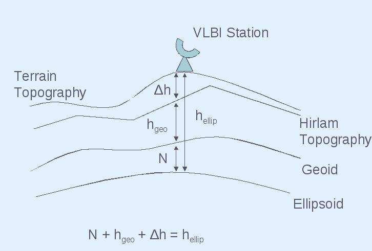
9 HIRLAM Topography
10 1 Introduction Delay of a signal propagating through the atmosphere 2 HIRLAM HIRLAM (High Resolution Limited Area Model) ECMWF vs HIRLAM HIRLAM Topography 3 Raytrace approach Raytrace program 4 Moritz approach Application of the Conformal Theory of Refraction Moritz approach 5 Conclusions
11 Raytrace program Davis, J.L., T.A.H. Herring and A.E. Niell, The Davis/Herring/Niell Raytrace program, HIRLAM input: Profiles 6 hours time resolution (00h, 06h, 12h, 18h) 22 km horizontal resolution 40 vertical levels refine to approx layers Atmosphere height extrapolated to 136 km Grid model: interpolation between the 4 nearest points around the station Raytrace program: Pressure, Temperature and Relative Humidity profiles at a starting height above sea level for each site and time epoch Elevation angle of each observation No Azimuth angle dependence Calculate Path Delay through the homogeneous atmosphere
12 1 Introduction Delay of a signal propagating through the atmosphere 2 HIRLAM HIRLAM (High Resolution Limited Area Model) ECMWF vs HIRLAM HIRLAM Topography 3 Raytrace approach Raytrace program 4 Moritz approach Application of the Conformal Theory of Refraction Moritz approach 5 Conclusions
13 Application of the Conformal Theory of Refraction (I) Derived by Moritz (1967) and developed by Brunner and Angus-Leppan (1976) Solution of Eikonal equation has been included in the equations Atmospheric propagation effects are evaluated along the known chord line and not along the unknown wave path Vacuum elevation angle is used so no iterative calculations are needed
14 Application of the Conformal Theory of Refraction (II) S = 10 6 S 0 NdX S 0 [( S dn 0 dy εdε)2 + ( S dn 0 dz εdε)2 ] dx X 2 where ε is a integration variable only If we neglect the small effect of curvature due to lateral refraction caused by dn dn dy 0, and dz = cosβ(dn dh ) where β is the vacuum elevation angle. Then practical approximation: S = 10 6 S 0 NdX cos2 β S 0 ( S 0 (dn dh )εdε)2 dx X 2
15 Interpolation in time Profiles 6 hours time resolution (00h, 06h, 12h, 18h): interpolation in time for each scan Interpolation in the horizontal Grid model: 22 km horizontal resolution Interpolation between the 4 nearest points around the station and each ray point in the atmosphere (check if it is in the same vertical profile) Interpolation in the vertical and refinement 40 vertical levels refine to approx layers (step size depend on atmosphere height) Atmosphere height extrapolated to 136 km Station height in the HIRLAM vertical profile (interpolation/extrapolation) Heights calculated over WG84 ellipsoid and undulations from potential coefficient model egm96 Moritz approach (I) HIRLAM input


16 One example from the side and the top Not in scale! Courtesy: Carolina ZG - 3dmax 2010
17 Moritz approach (II) Conformal Theory of Refraction, Moritz (1967) Elevation angle of each observation Azimuth angle dependence Neglect the small effect of curvature due to lateral refraction caused by dn dy 0 Starting integration at station height Size and number of integration steps along the chord line depend on vacuum elevation angle β and the current height of the ray point in the atmosphere (vertical refinement steps). Need to find a compromise with execution time (approx. 250 integration steps) Recalculate β at each ray point Calculate Path Delay through the 3D inhomogeneous atmosphere through the chord line
18 ZWD for CONT08 time series for Wettzell station using HIRLAM and other techniques (Teke et al. 2010) 1.4 ZWD differences 1.2 ZWD differences for RayTrace - Moritz (meters) Time every 3 hours from 11 August 2008 to 28 August 2008 Figure: ZTD multi-technique comparison, Teke et al. (2010) Figure: ZWD differences using HIRLAM profiles: ZWD calculation - scans at el=90 Forecast and analysis HIRLAM profiles are combinated Differences between HIRLAM comparison are due to improvements in interpolation (distance calculation) Mean = 0.83 mm Standard deviation of the mean = 0.02 mm
19 Difference in calculated slant delays Comparison between Raytrace & Moritz Slant delays (I) Homogeneous vs Inhomogeneous atmosphere 0.26 EURO75 - Delay Differences (m) for Effelsberg Station Delay differences: RayTrace - Moritz (m) Number observations Maximum difference = cm Minimum difference = 5.58 cm
 Homogeneous vs Inhomogeneous")
20 Difference in calculated slant delays Comparison between Raytrace & Moritz Slant delays (II) Homogeneous vs Inhomogeneous atmosphere
21 Inhomogeneous atmosphere for Effelsberg Moritz approach for EURO75 HIRLAM profile Effelsberg 25th March :00
22 Inhomogeneous atmosphere for Effelsberg Moritz approach for EURO75 HIRLAM profile Effelsberg 25th March :00
23 1 Introduction Delay of a signal propagating through the atmosphere 2 HIRLAM HIRLAM (High Resolution Limited Area Model) ECMWF vs HIRLAM HIRLAM Topography 3 Raytrace approach Raytrace program 4 Moritz approach Application of the Conformal Theory of Refraction Moritz approach 5 Conclusions
24 Conclusions and Future work Conclusions We have calculated slant delays using homogeneous and inhomogeneous atmosphere Raytrace approach simplifies to an homogeneous atmosphere Moritz approach includes the effect of an inhomogeneous atmosphere in the delay Differences between Raytrace and Moritz approach are the inhomogeneous atmosphere contributions Comparison of ZWDs and slant delays at elevation 90 using Moritz approach is in the order of 1 mm level due to improvements in the interpolation We calculate more precise and accurate slant delays with Moritz 3D approach Future work Comparison of Moritz slant delays raytrace through HIRLAM to other NWM e.g. ECMWF and other approaches e.g. KARAT We will analyze VLBI European data using the calculated slant delays as apriori
25 Thank you! Questions?
26 HIRLAM Surface Pressure vs
Principles of the Global Positioning System Lecture 15" Propagation Medium: Neutral atmosphere" Basic atmospheric structure"
 12.540 Principles of the Global Positioning System Lecture 15" Prof. Thomas Herring" Room 54-820A; 253-5941" tah@mit.edu" http://geoweb.mit.edu/~tah/12.540 " Propagation Medium: Neutral atmosphere" Summary"
Asymmetric Mapping Functions for CONT02 from ECMWF
 Asymmetric Mapping Functions for CONT2 from ECMWF Johannes Boehm, Marco Ess, Harald Schuh IGG, Vienna University of Technology Contact author: Johannes Boehm, e-mail: johannes.boehm@tuwien.ac.at Abstract
KAshima RAy-Tracing Service (KARATS)
") KAshima RAy-Tracing Service (KARATS) Fast ray-tracing algorithms through numerical weather models for real-time positioning applications in East Asia T. Hobiger, R. Ichikawa, Y. Koyama, T. Kondo Overview
KAshima RAy-Tracing Service (KARATS) Fast ray-tracing algorithms through numerical weather models for real-time positioning applications in East Asia T. Hobiger, R. Ichikawa, Y. Koyama, T. Kondo Overview
Refined Tropospheric Delay Models for CONT11
 Refined Tropospheric Delay Models for CONT11 manuscript No. (will be inserted by the editor) Refined Tropospheric Delay Models for CONT11 D. Landskron A. Hofmeister J. Böhm Received: date / Accepted: date
KAshima RAy-Tracing Service (KARATS)
") KAshima RAy-Tracing Service (KARATS) Fast ray-tracing through numerical weather models for real-time positioning applications ホビガートーマス 市川隆一 小山泰弘 近藤哲朗 第 6 回 IVS 技術開発センターシンポジウム 平成 19 年 3 月 9 日 Overview 1.
KAshima RAy-Tracing Service (KARATS) Fast ray-tracing through numerical weather models for real-time positioning applications ホビガートーマス 市川隆一 小山泰弘 近藤哲朗 第 6 回 IVS 技術開発センターシンポジウム 平成 19 年 3 月 9 日 Overview 1.
Ray-traced tropospheric delays in VLBI analysis
 RADIO SCIENCE, VOL. 47,, doi:10.1029/2011rs004918, 2012 Ray-traced tropospheric delays in VLBI analysis Vahab Nafisi, 1,2,3 Matthias Madzak, 2 Johannes Böhm, 2 Alireza A. Ardalan, 1 and Harald Schuh 2
Toward assimilating radio occultation data into atmospheric models
 Toward assimilating radio occultation data into atmospheric models Stig Syndergaard Institute of Atmospheric Physics The University of Arizona, Tucson, AZ Thanks to: Georg B. Larsen, Per Høeg, Martin B.
Title: Vienna Mapping Functions in VLBI Analyses. 1st author: Johannes Boehm. University of Technology, Vienna, Austria. 2nd author: Harald Schuh
 Title: Vienna Mapping Functions in VLBI Analyses 1st author: Johannes Boehm University of Technology, Vienna, Austria 2nd author: Harald Schuh University of Technology, Vienna, Austria Abstract In the
Can VMF1 be improved by the use of new ray-tracing data?
 Geodätische Woche October 11-13, 2016 Hamburg, Germany Can VMF1 be improved by the use of new ray-tracing data? Daniel Landskron, Armin Hofmeister, Johannes Böhm Technische Universität Wien, Austria Troposphere
Can VMF1 be improved by the use of new ray-tracing data?
 IAG Commission 4 Symposium September 4-7, 2016 Wrocław, Poland Can VMF1 be improved by the use of new ray-tracing data? Daniel Landskron, Armin Hofmeister, Johannes Böhm Technische Universität Wien, Austria
Signals of Opportunity for Atmospheric Remote Sensing. Balsubramani Goudar. University of Bath
 Signals of Opportunity for Atmospheric Remote Sensing submitted by Balsubramani Goudar for the degree of Doctor of Philosophy of the University of Bath Department of Electronics and Electrical Engineering
USE OF EDM AND PROPER REDUCTION OF OBSERVATIONS
 USE OF EDM AND PROPER REDUCTION OF OBSERVATIONS INTRODUCTION EDM stands for Electronic Distance Measurement. There are two basic types of EDM equipment, electro-optical (lightwaves) and electromagnetic
Improved Mapping of Tropospheric Delays
 JULY 001 ROCKEN ET AL. 105 Improved Mapping of Tropospheric Delays CHRISTIAN ROCKEN GPS Science and Technology Program, UCAR, Boulder, Colorado SERGEY SOKOLOVSKIY GPS Science and Technology Program, UCAR,
UNIVERSITY CALIFORNIA, RIVERSIDE AERIAL TARGET GROUND CONTROL SURVEY REPORT JOB # DATE: MARCH 2011
 UNIVERSITY CALIFORNIA, RIVERSIDE AERIAL TARGET GROUND CONTROL SURVEY REPORT JOB # 2011018 DATE: MARCH 2011 UNIVERSITY CALIFORNIA, RIVERSIDE AERIAL TARGET GROUND CONTROL SURVEY REPORT I. INTRODUCTION II.
Purpose : Understanding Projections, 12D, and the System 1200.
 Purpose : Understanding Projections, 12D, and the System 1200. 1. For any Cad work created inside 12D, the distances entered are plane (Horizontal Chord) distances. 2. Setting a projection, or changing
Developments towards use of external tropospheric models in GNSS positioning and navigation
 Developments towards use of external tropospheric models in GNSS positioning and navigation Jan Douša, Michal Eliaš Geodetic Observatory Pecný, RIGTC, Czech Republic Florian Zus Deutsches GeoForschungsZentrum
Levenberg-Marquardt minimisation in ROPP
 Ref: SAF/GRAS/METO/REP/GSR/006 Web: www.grassaf.org Date: 4 February 2008 GRAS SAF Report 06 Levenberg-Marquardt minimisation in ROPP Huw Lewis Met Office, UK Lewis:Levenberg-Marquardt in ROPP GRAS SAF
State Plane Coordinates and Computations using them GISC Spring 2013
 State Plane Coordinates and Computations using them GISC-3325 - Spring 2013 Map Projections From UNAVCO site hosting.soonet.ca/eliris/gpsgis/lec2geodesy.html Taken from Ghilani, SPC State Plane Coordinate
Interpolation of gridded data using Geostrophic Balance. Lennon O Naraigh *
 Interpolation of gridded data using Geostrophic Balance Lennon O Naraigh * Date: 6 th September 2004 Abstract: In this report, a method of interpolating data from the grid of a global climate model (GCM)
A New Tropospheric Propagation Delay Mapping Function for Elevation Angles Down to 2 o
 A New Tropospheric Propagation Delay Mapping Function for Elevation Angles Down to 2 o Jiming Guo, School of Geodesy and Geomatics, Wuhan University, China Richard B. Langley, Department of Geodesy and
MET 4410 Remote Sensing: Radar and Satellite Meteorology MET 5412 Remote Sensing in Meteorology. Lecture 9: Reflection and Refraction (Petty Ch4)
") MET 4410 Remote Sensing: Radar and Satellite Meteorology MET 5412 Remote Sensing in Meteorology Lecture 9: Reflection and Refraction (Petty Ch4) When to use the laws of reflection and refraction? EM waves
MET 4410 Remote Sensing: Radar and Satellite Meteorology MET 5412 Remote Sensing in Meteorology Lecture 9: Reflection and Refraction (Petty Ch4) When to use the laws of reflection and refraction? EM waves
Sensing atmospheric structure: Tropospheric tomographic results of the small-scale GPS campaign at the Onsala Space Observatory
 LETTER Earth Planets Space, 52, 941 945, 2000 Sensing atmospheric structure: Tropospheric tomographic results of the small-scale GPS campaign at the Onsala Space Observatory A. Flores 1, L. P. Gradinarsky
REQUEST FOR A SPECIAL PROJECT
 REQUEST FOR A SPECIAL PROJECT 2018 2020 MEMBER STATE: Germany, Greece, Italy This form needs to be submitted via the relevant National Meteorological Service. Principal Investigator 1 Amalia Iriza (NMA,Romania)
Exterior Orientation Parameters
 Exterior Orientation Parameters PERS 12/2001 pp 1321-1332 Karsten Jacobsen, Institute for Photogrammetry and GeoInformation, University of Hannover, Germany The georeference of any photogrammetric product
Assimilating GPS radio occultation measurements with two-dimensional bending angle observation operators
 QUARTERLY JOURNAL OF THE ROYAL METEOROLOGICAL SOCIETY Q. J. R. Meteorol. Soc. 133: 1213 1227 (2007) Published online 6 July 2007 in Wiley InterScience (www.interscience.wiley.com).63 Assimilating GPS radio
The Open Atmospheric Science Journal
 Send Orders for Reprints to reprints@benthamscience.ae The Open Atmospheric Science Journal, 07,, - The Open Atmospheric Science Journal Content list available at: www.benthamopen.com/toascj/ DOI: 0.74/87483070000
TROPPO A Tropospheric Propagation Simulator
 TROPPO A Tropospheric Propagation Simulator Dr Carlo Kopp, MIEEE, MAIAA, PEng Clayton School of IT, Monash University CSSE Technical Report 161/2004 Reference Sources and Bibliography 1. Ippolito L.J.
Gridded Data Speedwell Derived Gridded Products
 Gridded Data Speedwell Derived Gridded Products Introduction Speedwell Weather offers access to a wide choice of gridded data series. These datasets are sourced from the originating agencies in their native
Parameterization of tropospheric delay correction for mobile GNSS positioning: a case study of a cold front passage
 METEOROLOGICAL APPLICATIONS Meteorol. Appl. 15: 447 454 (2008) Published online 11 August 2008 in Wiley InterScience (www.interscience.wiley.com).86 Parameterization of tropospheric delay correction for
Terrafirma: a Pan-European Terrain motion hazard information service.
 Terrafirma: a Pan-European Terrain motion hazard information service www.terrafirma.eu.com The Future of Terrafirma - Wide Area Product Nico Adam and Alessandro Parizzi DLR Oberpfaffenhofen Terrafirma
Progress in the assimilation of GPS-RO at ECMWF
 Progress in the assimilation of GPS-RO at ECMWF Sean Healy Mike Rennie, Milan Dragosavac, Paul Poli, Carla Cardinali, Peter Bauer. Impact of GPS-RO The impact of GPS-RO NWP and climate reanalysis applications
Estimation of elevation dependent deformations of a parabolic reflector of a large radio telescope
 . Estimation of elevation dependent deformations of a parabolic reflector of a large radio telescope 1 Christoph Holst & Heiner Kuhlmann JISDM, 2-4 November 2011, Hong Kong, China . Motivation Laser Scanner
Simulating the influence of horizontal gradients on refractivity profiles from radio occultations
 Simulating the influence of horizontal gradients on refractivity profiles from radio occultations a promising approach for data assimilation S. Syndergaard, D. Flittner, R. Kursinski, and B. Herman Institute
Improvement of Current Refraction Modeling in Satellite Laser Ranging (SLR) by Ray Tracing through Meteorological Data
 by Ray Tracing through Meteorological Data") Improvement of Current Refraction Modeling in Satellite Laser Ranging (SLR) by Ray Tracing through Meteorological Data G. Hulley and E. C. Pavlis 1. Joint Center for Earth Systems Technology (JCET), UMBC,
Improvement of Current Refraction Modeling in Satellite Laser Ranging (SLR) by Ray Tracing through Meteorological Data G. Hulley and E. C. Pavlis 1. Joint Center for Earth Systems Technology (JCET), UMBC,
Ray optics! Postulates Optical components GRIN optics Matrix optics
 Ray optics! Postulates Optical components GRIN optics Matrix optics Ray optics! 1. Postulates of ray optics! 2. Simple optical components! 3. Graded index optics! 4. Matrix optics!! From ray optics to
5 Classifications of Accuracy and Standards
 5 Classifications of Accuracy and Standards 5.1 Classifications of Accuracy All surveys performed by Caltrans or others on all Caltrans-involved transportation improvement projects shall be classified
Spring Term. Lecturer: Assoc. Prof. Dr. M. Zeki COŞKUN. Department of Geomatics Engineering
 2009 2010 Spring Term Lecturer: Assoc. Prof. Dr. M. Zeki COŞKUN Department of Geomatics Engineering e-mail : coskun@itu.edu.tr LEVELLING What is Levelling? Use of Levelling Levelling Terminology Types
High-Precision Positioning Unit 2.2 Student Exercise: Calculating Topographic Change
 High-Precision Positioning Unit 2.2 Student Exercise: Calculating Topographic Change Ian Lauer and Ben Crosby (Idaho State University) Change is an inevitable part of our natural world and varies as a
Training i Course Remote Sensing Basic Theory & Image Processing Methods September 2011
 Training i Course Remote Sensing Basic Theory & Image Processing Methods 19 23 September 2011 Geometric Operations Michiel Damen (September 2011) damen@itc.nl ITC FACULTY OF GEO-INFORMATION SCIENCE AND
Formulas and constants for the calculation of the Swiss conformal cylindrical projection and for the transformation between coordinate systems
 _ìåçéë~ãíñωêi~åçéëíçéçöê~ñáé lññáåéñ Ç ê~äçéíçéçöê~éüáé péñíáöéåëíê~ëëéosq `ejpmuqt~äéêå rññáåáçñéçéê~äéçáíçéçöê~ñá~ qéäéñçå HQNPNVSPONNN céçéê~älññáåéçñqçéçöê~éüó qéäéñ~ñ HQNPNVSPOQRV Formulas and constants
Regional Cooperation for Limited Area Modeling in Central Europe. Dynamics in LACE. Petra Smolíková thanks to many colleagues
 Dynamics in LACE Petra Smolíková thanks to many colleagues Outline 1 1. VFE NH Design of vertical finite elements scheme for NH version of the model 2. SL scheme Application of ENO technique to SL interpolations
ENGI 3703 Surveying and Geomatics
 Differential Level Errors We discussed the Canadian datum used in leveling and leveling methods and equipment in the field practice. However, there are a number of errors that we should consider in more
Simulating the influence of horizontal gradients on refractivity profiles from radio occultation measurements
 Simulating the influence of horizontal gradients on refractivity profiles from radio occultation measurements a promising approach for data assimilation S. Syndergaard, D. Flittner, R. Kursinski, and B.
Ray Trace Notes. Charles Rino. September 2010
 Ray Trace Notes Charles Rino September 2010 1 Introduction A MATLAB function that performs a direct numerical integration to the ray optics equation described in book Section 1.3.2 has been implemented.
Chapters 1 9: Overview
 Chapters 1 9: Overview Chapter 1: Introduction Chapters 2 4: Data acquisition Chapters 5 9: Data manipulation Chapter 5: Vertical imagery Chapter 6: Image coordinate measurements and refinements Chapters
Chapters 1 7: Overview
 Chapters 1 7: Overview Chapter 1: Introduction Chapters 2 4: Data acquisition Chapters 5 7: Data manipulation Chapter 5: Vertical imagery Chapter 6: Image coordinate measurements and refinements Chapter
New Technologies For The Real 3D Reference Point Determination
 New Technologies For The Real 3D Reference Point Determination Maria Hennes, Cornelia Eschelbach GIK, Geodetic Institute of the University of Karlsruhe, Germany Contact author: Maria Hennes, e-mail: hennes@gik.uni-karlsruhe.de
VLBI observation biases induced by antenna gravitational flexures
 VLBI observation biases induced by antenna gravitational flexures Pierguido Sarti Institute of Radio Astronomy Bologna National Institute of Astrophysics Italy AGU Fall Meeting 2012 - Dec. 7, 2012 The
COORDINATE TRANSFORMATION. Lecture 6
 COORDINATE TRANSFORMATION Lecture 6 SGU 1053 SURVEY COMPUTATION 1 Introduction Geomatic professional are mostly confronted in their work with transformations from one two/three-dimensional coordinate system
WHERE THEORY MEETS PRACTICE
 world from others, leica geosystems WHERE THEORY MEETS PRACTICE A NEW BULLETIN COLUMN BY CHARLES GHILANI ON PRACTICAL ASPECTS OF SURVEYING WITH A THEORETICAL SLANT february 2012 ² ACSM BULLETIN ² 27 USGS
inter.noise 2000 The 29th International Congress and Exhibition on Noise Control Engineering August 2000, Nice, FRANCE
 Copyright SFA - InterNoise 2000 1 inter.noise 2000 The 29th International Congress and Exhibition on Noise Control Engineering 27-30 August 2000, Nice, FRANCE I-INCE Classification: 2.4 NORD 2000. STATE-OF-THE-ART
GeOlympus. GeoPACS GeoTR GeoStaR GeoWZ
 GeOlympus GeoPACS GeoTR GeoStaR GeoWZ GeOlympus Workstation Work station Reflection time Refracted waves first arrivals Additional information Static and NMO corrections Layer by layer delay and statics
Geometric Accuracy Evaluation, DEM Generation and Validation for SPOT-5 Level 1B Stereo Scene
 Geometric Accuracy Evaluation, DEM Generation and Validation for SPOT-5 Level 1B Stereo Scene Buyuksalih, G.*, Oruc, M.*, Topan, H.*,.*, Jacobsen, K.** * Karaelmas University Zonguldak, Turkey **University
Definition of Basic Polar Data Product
 Definition of Basic Polar Data Product OPERA project 1d3: working document WD 02 03 Iwan Holleman and Gianmario Galli Date: September 22, 2003 1 1 Introduction During the OPERA project an additional deliverable
Total Station & Distomat
 UNIT 6 Total Station & Distomat Learning Objectives After studying this unit, the student will be able to Understand the parts of Total station Temporary adjustments of total station Measurement of horizontal
Creating a new Rayfract profile, importing the SEG-2 trace files and the Gremix header data :
 RAYFRACT Tutorial specific to IGT line 14 : The seven SEG-2 formatted shot sorted binary trace data files and the Interpex Gremix.GRM file used to import first breaks as described below are available on
The use of minimum curvature surface technique in geoid computation processing of Egypt
 Arab J Geosci (2013) 6:1263 1272 DOI 10.1007/s12517-011-0418-0 ORIGINAL PAPER The use of minimum curvature surface technique in geoid computation processing of Egypt M. Rabah M. Kaloop Received: 25 June
A mass-conservative version of the semi- Lagrangian semi-implicit HIRLAM using Lagrangian vertical coordinates
 A mass-conservative version of the semi- Lagrangian semi-implicit HIRLAM using Lagrangian vertical coordinates Peter Hjort Lauritzen Atmospheric Modeling & Predictability Section National Center for Atmospheric
DEVELOPMENT OF A TOOL FOR OFFSHORE WIND RESOURCE ASSESSMENT FOR WIND INDUSTRY
 DEVELOPMENT OF A TOOL FOR OFFSHORE WIND RESOURCE ASSESSMENT FOR WIND INDUSTRY Alberto Rabaneda Dr. Matthew Stickland University of Strathclyde Mechanical and Aerospace Engineering Department Wind resource
Neusiedler See project
 Young Authors Paper Analysis of ALS data and products in the Neusiedler See project Maja Bitenc Objectives Technology of ALS Project Neusiedler See. Analyse of DTM quality Analyse of intensity Conclusion
STRAIGHT LINE REFERENCE SYSTEM STATUS REPORT ON POISSON SYSTEM CALIBRATION
 STRAIGHT LINE REFERENCE SYSTEM STATUS REPORT ON POISSON SYSTEM CALIBRATION C. Schwalm, DESY, Hamburg, Germany Abstract For the Alignment of the European XFEL, a Straight Line Reference System will be used
Migration from a non-flat datum via reverse-time extrapolation
 Stanford Exploration Project, Report 84, May 9, 2001, pages 1 50 Migration from a non-flat datum via reverse-time extrapolation Gopal Palacharla 1 ABSTRACT Land surveys usually have elevation changes,
PARAMETERIZATION OF DRAG FORCES IN URBAN CANOPY MODELS USING MICROSCALE-CFD MODELS FOR DIFFERENT WIND DIRECTIONS
 PARAMETERIZATION OF DRAG FORCES IN URBAN CANOPY MODELS USING MICROSCALE-CFD MODELS FOR DIFFERENT WIND DIRECTIONS J. L. Santiago 1, O. Coceal 2 and A. Martilli 1 1 Atmospheric Pollution Division, Environmental
S. Syndergaard, D. Flittner, R. Kursinski, and B. Herman Institute of Atmospheric Physics, The University of Arizona, Tucson, Arizona, U.S.A.
 SIMULATING THE INFLUENCE OF HORIZONTAL GRADIENTS ON REFRACTIVITY PROFILES FROM RADIO OCCULTATIONS S. Syndergaard, D. Flittner, R. Kursinski, and B. Herman Institute of Atmospheric Physics, The University
RAILWAY PROJECT Geodetic Reference System, Geodetic Control Network and Rail Construction Measurements
 RAILWAY PROJECT Geodetic Reference System, Geodetic Control Network and Rail Construction Measurements Railway Project 2 / 8 INDEX 1 Introduction... 3 2 Reference System... 3 2.1 Reference system... 3
Terrain correction. Backward geocoding. Terrain correction and ortho-rectification. Why geometric terrain correction? Rüdiger Gens
 Terrain correction and ortho-rectification Terrain correction Rüdiger Gens Why geometric terrain correction? Backward geocoding remove effects of side looking geometry of SAR images necessary step to allow
60 GHz WLAN. 03 Name Affiliations Address Phone . Schleinitzstraße Braunschweig
 Deterministic i i Channel lmodeling for 60 GHz WLAN Authors: Date: 2009-03-10 03 Name Affiliations Address Phone email Martin Jacob Thomas Kürner TU Braunschweig, Germany TU Braunschweig, Germany Schleinitzstraße
Light and the Properties of Reflection & Refraction
 Light and the Properties of Reflection & Refraction OBJECTIVE To study the imaging properties of a plane mirror. To prove the law of reflection from the previous imaging study. To study the refraction
Dome and Mirror Seeing Estimates for the Thirty Meter Telescope
 Dome and Mirror Seeing Estimates for the Thirty Meter Telescope John S. Pazder a, Konstantinos Vogiatzis b, and George Z. Angeli b, a National Research Council Canada, Herzberg Institute of Astrophysics
ROPIC First Assessment
 ROPIC First Assessment Introduction.... 5 Motivation for ROPIC, The Radio Occultation Processing Intercomparison Campaign.... 5 Objectives of this project... 5 1. The ROPIC Project... 6 2. The ROPIC Data
The Differential df, the Gradient f, & the Directional Derivative Dû f sec 14.4 (cont), Goals. Warm-up: Differentiability. Notes. Notes.
, Goals. Warm-up: Differentiability. Notes. Notes.") The Differential df, the Gradient f, & the Directional Derivative Dû f sec 14.4 (cont), 14.5 10 March 2014 Goals. We will: Define the differential df and use it to approximate changes in a function s value.
The Differential df, the Gradient f, & the Directional Derivative Dû f sec 14.4 (cont), 14.5 10 March 2014 Goals. We will: Define the differential df and use it to approximate changes in a function s value.
PROPAGATION OF REFRACTION ERRORS IN TRIGONOMETRIC HEIGHT TRAVERSING AND GEODETIC LEVELLING
 PROPAGATION OF REFRACTION ERRORS IN TRIGONOMETRIC HEIGHT TRAVERSING AND GEODETIC LEVELLING G. A. KHARAGHANI November 1987 TECHNICAL REPORT NO. 132 PREFACE In order to make our extensive series of technical
PHILADELPHIA UNIVERSITY Faculty of Engineering. Department of Civil Engineering. SURVEYING. Chapter 3. Leveling
 PHILADELPHIA UNIVERSITY Faculty of Engineering. Department of Civil Engineering. SURVEYING Chapter 3 Leveling Leveling Leveling: the operation of determining the difference in elevation between points.
GPS Radio Occultation Observation Operators for NWP Models
 GPS Radio Occultation Observation Operators for NWP Models Stig Syndergaard (with input from Bill Kuo) COSMIC Project Office University Corporation for Atmospheric Research FORMOSAT-3/COSMIC Science Summer
Draw a diagram showing the fibre and the path of the ray of light. Describe one use of optical fibres in medicine. You may draw a diagram.
 1 (a) (i) A ray of light passes through a length of curved optical fibre. Draw a diagram showing the fibre and the path of the ray of light. [1] Describe one use of optical fibres in medicine. You may
Determination of orthometric heights from LiDAR data
 International conference on Innovative Methods in Product Design June 15 th 17 th, 2011, Venice, Italy Determination of orthometric heights from LiDAR data J. L. Pérez (a), A. T. Mozas (a), A. López (a),
Quantifying the Dynamic Ocean Surface Using Underwater Radiometric Measurement
 DISTRIBUTION STATEMENT A. Approved for public release; distribution is unlimited. Quantifying the Dynamic Ocean Surface Using Underwater Radiometric Measurement Lian Shen Department of Mechanical Engineering
ifp Universität Stuttgart Performance of IGI AEROcontrol-IId GPS/Inertial System Final Report
 Universität Stuttgart Performance of IGI AEROcontrol-IId GPS/Inertial System Final Report Institute for Photogrammetry (ifp) University of Stuttgart ifp Geschwister-Scholl-Str. 24 D M. Cramer: Final report
THE EFFECT OF HORIZONTAL REFRACTION ON BACK-AZIMUTH ESTIMATION FROM THE CTBT HYDROACOUSTIC STATIONS IN THE INDIAN OCEAN
 THE EFFECT OF HORIZONTAL REFRACTION ON BACK-AZIMUTH ESTIMATION FROM THE CTBT HYDROACOUSTIC STATIONS IN THE INDIAN OCEAN Binghui Li a, Alexander Gavrilov a and Alec Duncan a a Centre for Marine Science
Progress Report on: Interferometric Interpolation of 3D SSP Data
 Progress Report on: Interferometric Interpolation of 3D SSP Data Sherif M. Hanafy ABSTRACT We present the theory and numerical results for interferometrically interpolating and extrapolating 3D marine
Improvements to a GPS radio occultation ray-tracing model and their impacts on assimilation of bending angle
 JOURNAL OF GEOPHYSICAL RESEARCH, VOL. 108, NO. D17, 4548, doi:10.1029/2002jd003160, 2003 Improvements to a GPS radio occultation ray-tracing model and their impacts on assimilation of bending angle H.
External, initial and boundary data. Rodica Claudia DUMITRACHE Amalia IRIZA
 External, initial and boundary data Rodica Claudia DUMITRACHE Amalia IRIZA Necessary Data to run the System COSMO topography ICON/ GME analysis/forecast int2lm COSMO analysis/lbc data ICON/ GME topography
Parametric Approaches for Refractivity-From-Clutter Inversion
 Parametric Approaches for Refractivity-From-Clutter Inversion Peter Gerstoft Marine Physical Laboratory, Scripps Institution of Oceanography La Jolla, CA 92093-0238 phone: (858) 534-7768 fax: (858) 534-7641
Surveying. Session GPS Surveying 1. GPS Surveying. Carrier-Phase (RTK) Pseudo-Range (DGPS) Slide 1
 Pseudo-Range (DGPS) Slide 1") GPS Surveying Slide 1 GPS Surveying Surveying Mapping Standalone Relative Relative Standalone Post-Processed Real-Time Static / Fast Static Kinematic Stop & Go Rapid-Static Carrier-Phase (RTK) Pseudo-Range
GPS Surveying Slide 1 GPS Surveying Surveying Mapping Standalone Relative Relative Standalone Post-Processed Real-Time Static / Fast Static Kinematic Stop & Go Rapid-Static Carrier-Phase (RTK) Pseudo-Range
Chapter 1: Overview. Photogrammetry: Introduction & Applications Photogrammetric tools:
 Chapter 1: Overview Photogrammetry: Introduction & Applications Photogrammetric tools: Rotation matrices Photogrammetric point positioning Photogrammetric bundle adjustment This chapter will cover the
MODELLING OF PROPAGATION OVER NON-HOMOGENEOUS EARTH WITH PARABOLIC EQUATION METHOD
 ODELLING OF PROPAGATION OVER NON-HOOGENEOUS EARTH WITH PARABOLIC EQUATION ETHOD Esin ÖZÇAKICILAR 1 Funda AKLEAN 1 Uludag UniversityEngineering-Architecture Faculty Electronic Engineering Department 1659-Görükle/BURSA
Comparison of height differences obtained by trigonometric and spirit leveling method
 UDC: 528.482:519.23 DOI: 10.14438/gn.2015.01 Typology: 1.01 Original Scientific Article Comparison of height differences obtained by trigonometric and spirit leveling method Žarko NESTOROVIĆ 1, Siniša
Introduction to Objective Analysis
 Chapter 4 Introduction to Objective Analysis Atmospheric data are routinely collected around the world but observation sites are located rather randomly from a spatial perspective. On the other hand, most
Tracking Weather Storms using 3D Doppler Radial Velocity Information
 Tracking Weather Storms using 3D Doppler Radial Velocity Information X. Tang 1 and J.L. Barron 1,R.E.Mercer 1,andP.Joe 2 1 Department of Computer Science University of Western Ontario London, Ontario,
Refractive Effects, Turbulence, and the EOSTAR model
 Refractive Effects, Turbulence, and the EOSTAR model Stephen Doss-Hammel a, Dimitri Tsintikidis a, Alexander van Eijk b, and Gerard Kunz b a Atmospheric Propagation Branch code 2858, Space and Naval Warfare
Space = p-s p-s 1 r (2)
") Space Johannes Raggam Institut~ for hnage Processing and Computer Graphics Forschungsgesellschaft J oanneum Graz, Austria Commi~sion II Abstract Parametric SAR geocoding algorithms, which make use of a
Space Johannes Raggam Institut~ for hnage Processing and Computer Graphics Forschungsgesellschaft J oanneum Graz, Austria Commi~sion II Abstract Parametric SAR geocoding algorithms, which make use of a
Towards a Lower Helicopter Noise Interference in Human Life
 Towards a Lower Helicopter Noise Interference in Human Life Fausto Cenedese Acoustics and Vibration Department AGUSTA, Via G. Agusta 520, 21017 Cascina Costa (VA), Italy Noise Regulation Workshop September
e. \ 2-99 Calculation ofray Amplitudes: We seek a computationally tractable method to estimate ray
 2-99 e. \ Michael C. Fehler, Steven T. Hildebrand, Lianjie Huang, and Douglas Alde MS 044; Los Alamos National Laboratiory; Los Alamos, NM 87545 USA Summary: Kirchhoff migration using ray tracing travel
Análisis de la generación dinámica de transformaciones geodésicas en forma de mensajes RTCM 3.1 y su emisión en tiempo real
 Analysis of dynamic generation and real time transmission of RTCM 3.1 geodetic transformation messages Análisis de la generación dinámica de transformaciones geodésicas en forma de mensajes RTCM 3.1 y
Refraction at a single curved spherical surface
 Refraction at a single curved spherical surface This is the beginning of a sequence of classes which will introduce simple and complex lens systems We will start with some terminology which will become
Networks & Deformation Analysis :45 14:30 HIL C 71.3
 Networks & Deformation Analysis 10.11.2010 13:45 14:30 HIL C 71.3 Prof. Dr. H. Ingensand Geodetic Metrology and Engineering Geodesy 04.11.2010 Networks & Deformation Analysis Contents Coordinate Systems
Geometric Optics. The Law of Reflection. Physics Waves & Oscillations 3/20/2016. Spring 2016 Semester Matthew Jones
 Physics 42200 Waves & Oscillations Lecture 27 Propagation of Light Hecht, chapter 5 Spring 2016 Semester Matthew Jones Geometric Optics Typical problems in geometric optics: Given an optical system, what
Ray optics! 1. Postulates of ray optics! 2. Simple optical components! 3. Graded index optics! 4. Matrix optics!!
 Ray optics! 1. Postulates of ray optics! 2. Simple optical components! 3. Graded index optics! 4. Matrix optics!! From ray optics to quantum optics! Ray optics! Wave optics! Electromagnetic optics! Quantum
Quantifying the Dynamic Ocean Surface Using Underwater Radiometric Measurement
 DISTRIBUTION STATEMENT A. Approved for public release; distribution is unlimited. Quantifying the Dynamic Ocean Surface Using Underwater Radiometric Measurement Lian Shen Department of Mechanical Engineering
Mass-flux parameterization in the shallow convection gray zone
 Mass-flux parameterization in the shallow convection gray zone LACE stay report Toulouse Centre National de Recherche Meteorologique, 15. September 2014 26. September 2014 Scientific supervisor: Rachel