Chapter 7. Joining Maps to Other Datasets in QGIS
|
|
|
- Valentine Perkins
- 5 years ago
- Views:
Transcription
1 Chapter 7 Joining Maps to Other Datasets in QGIS Skills you will learn: How to join a map layer to a non-map layer in preparation for analysis, based on a common joining field shared by the two tables. If you are unfamiliar with the basic functionality of QGIS, such as how to add map layers and other data tables to the map document, please review the tutorial A Quick Tour of QGIS Desktop, which you can access by clicking here. Getting started Add the map layer and the non-geographic layer to the data frame. For the purposes of this illustration, we are using a shapefile of census tracts in Winnipeg, Manitoba, Canada and a dataset of median household income from the census. This is what the attribute table looks like for the map layer.


2 And this is what the csv data table looks like in the data table when we open it in Excel:

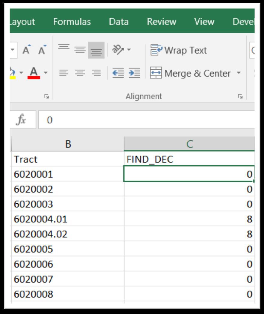
3 Making the join Eventually, we will join Tract, column B, with the first column in the census tract attribute table that we ve opened in QGIS, as displayed in the first screen grab. However, we must add a decimal and two zeros to the census tract ID numbers in column B above. Failure to do so, means that tracts without decimal points will not be joined to their corresponding tracts in the census tract table. And unlike ArcGIS, QGIS will import the values in column B as numbers. Under normal circumstances this would be fine. However, you ll notice that the census tract field in QGIS, CTUID, is left-justified, meaning that it s text. In order for the join to happen, the corresponding field in the csv file must be the same datatype. So we ll have to carry out two steps: run two functions to add two decimal points to the census tract numbers in the csv file, and then convert the column to text; then we must create what s called a csvt file that essentially instructs QGIS to import the values in that column as text. Adding the decimal point and two zeros Take a closer look at the Tract column in our csv file.

4 The values in the first three rows contain no decimal places. The values in the fourth and fifth rows do. Now let s look at the corresponding values in the census tract file that we ve opened in QGIS s attribute table. Two problems. The first three values have a decimal place, followed by two zeros. And, as we mentioned previously, QGIS is interpreting the numbers as text because they are left-justified. So, in the csv file, we must add a decimal place and two zeros to the numbers that don t have them. Save the csv file as an Excel workbook. This is necessary because the csv file will not retain the functions that you ll be writing to add the zeros, as well as the new column.

5 Create two columns to the right of column B. Reformat column B as text. And in column C, type FIND_DEC ( find decimal ) in C1.
),0,SEARCH(\".")
6 Then type the following formula in C2. =IF(ISERROR(SEARCH(".",B2)),0,SEARCH(".",B2))

7 Copy the formula to the bottom. The formula does the following: if there is a decimal in the numbers in the Tract column, it will return the number that represents the number of characters from the left. If the decimal does not appear, it returns 0. You should have a column full of 8s, and 0s. Copy column C and use the paste special option to plug the values into column D. If you can t remember how to do this, please refer to Chapter 4 s paste-special tutorial. Once you ve pasted the new numbers, delete column C, and give our new column the same name. Looking at the value in the formula bar, you ll notice that the paste special has eliminated the function and just retained the value.
8

9 Now you should still have an empty column to the left of column C. Give column D the label CUID, and type this function. =IF(C2=0,B2&".00",B2). Pages in Chapter 4 discusses IF statements, as does the accompanying tutorial, For working with specialized functions in Excel tutorial. Translated, the function in the formula bar says if the value in C2 equals zero, then use the concatenation operator (&) to add a decimal and two zeros (.00) to the value in B2. The decimal and two zeros constitute a condition, and as such must be bracketed by quotation marks. If C2 does not equal zero, then simply re-produce the value in the corresponding cell in column B.

10 Copy the formula to the bottom of column D and format the numbers as text.

11 Now let s use the paste special to get rid of the formula in column D by copying the column.

12

13


14 Be sure to save the values as text, meaning that they are left-justified. Now you can delete all the columns to the left of D. If we were importing this file into ArcGIS, we could simply save the file in Excel format. However, QGIS deals with csv files. There remains one more step before saving the Excel file as a csv file, and then importing the table into QGIS. QGIS will import column A as a number format. So we have to use a text file with a csvt extension that will, in essence, force QGIS to recognize our column as text, not


15 numbers. The csvt file only contains one row which specifies the datatypes for each column. And this is crucial: the csvt file MUST have the SAME name as the Excel file that we will save in csv format, and go in the SAME directory as that csv file. You can create the csvt file in a notepad, or one of the many open-sourced text editors discussed in the Appendix A. Our csvt file looks like this, which is created in the text editor, EmEditor. String defines text; integer, a number. The csvt file defines each datatype in the csv file. The key is the first column. The string tells QGIS to import the CUID column as text. Once you ve created the csvt file, save the Excel worksheet as a csv file. Remember, the csv and csvt files MUST have the SAME name, and be in the SAME folder. Importing the files into QGIS Open QGIS and use the Add Vector Layer icon to browse for, and then import the Winnipeg census tract shape file.

16


17

18 Right-click on the layer in the menu to the left to obtain your attribute table. Selecting the Open Attribute Table option produces a dialog table which contains the geographic information QGIS like ArcGIS uses to map the census boundaries.
19 Close the attribute table. And use the Add Delimited Text Layer option to browse for an import our csv file.

20 Now browse for the csv file, which should be right with the csvt file that we have created.

21 Next, we get a Create a Layer from a Delimited Text File dialogue box. QGIS has rightly guessed that it s a csv file. Since it doesn t have any X and Y geographic coordinates which come into play when performing spatial joins, click the box that specifies that there are No geometry coordinates.
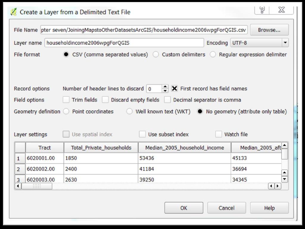
22

23 Select the OK tab.

24 Now we have a second file in our layer menu. Just as we did with the census tract file, open the attribute table to see what s there. Thanks to the csvt file, QGIS imported the values in the CUID column as and string, or text, and the rest of the values as integers or numbers. The latter is also important because QGIS, like ArcGIS, (Or Excel or MySQL, for that matter) can only do math on numbers.

25 Close the attribute table. And right click on the Winnipeg census tract layer to obtain our short cut menu.

26 Select Properties, which should open to the general tab which contains information we ll explain in the spatial join tutorial.

27 Select Joins.

28 For specific values to appear on the map, we must join it to the Map. And the green plus sign at the bottom left. Because we ve already selected the Winnipeg census tract layer, our Join layer is the csv file. The Join field is CUID, the new one we created and renamed earlier in this tutorial. The Target field in the Winnipeg census tract file is the CTUID field.
29 Select the OK tab. At the top of the dialogue box, we can see that QGIS has informed us that the join has been executed. So select the Apply tab, and then OK. For further evidence that we have successfully joined the csv file to the census tract shape file, right click on the latter to obtain the attribute table, and expand the width in order to see all the columns.

30 The first three columns belong to our shape file; the rest, to the csv file. Close the attribute table. We will learn how to colour code the results in the 7_16_MakingChoroplethinQgis tutorial. Now we have successfully mapped the cities income levels and have an idea what areas have neighborhoods where we might want to visit.
Tutorial for mapping Census 2016 data in Qgis by census tracts
 Tutorial for mapping Census 2016 data in Qgis by census tracts Skills you will learn: How to join a Census 2016 map layer to a Census 2016 non-map layer, based on a common joining field shared by the two
The Data Journalist Chapter 7 tutorial Geocoding in ArcGIS Desktop
 The Data Journalist Chapter 7 tutorial Geocoding in ArcGIS Desktop Summary: In many cases, online geocoding services are all you will need to convert addresses and other location data into geographic data.
Census tutorial using the city of Ottawa s wards
 Census tutorial using the city of Ottawa s wards Every five years, Statistics Canada uses the Census Program to collect vital data about Canadians that paints a portrait of who we are. Traditionally, the
TUTORIAL FOR IMPORTING OTTAWA FIRE HYDRANT PARKING VIOLATION DATA INTO MYSQL
 TUTORIAL FOR IMPORTING OTTAWA FIRE HYDRANT PARKING VIOLATION DATA INTO MYSQL We have spent the first part of the course learning Excel: importing files, cleaning, sorting, filtering, pivot tables and exporting
TUTORIAL FOR IMPORTING OTTAWA FIRE HYDRANT PARKING VIOLATION DATA INTO MYSQL
 TUTORIAL FOR IMPORTING OTTAWA FIRE HYDRANT PARKING VIOLATION DATA INTO MYSQL We have spent the first part of the course learning Excel: importing files, cleaning, sorting, filtering, pivot tables and exporting
Chapter 7. Buffering in QGIS Desktop
 Chapter 7 Buffering in QGIS Desktop Summary: How far away is that? How many are too close? These are some of the most compelling mapping questions journalists can ask. A buffer is one of the most useful
Downloading 2010 Census Data
 Downloading 2010 Census Data These instructions cover downloading the Census Tract polygons and the separate attribute data. After that, the attribute data will need additional formatting in Excel before
Mapping discarded needles in Fusion Tables Tutorial
 Mapping discarded needles in Fusion Tables Tutorial In the previous tutorials, we ve learned how to turn pivot tables into heat maps and place colour code geographic points using markers that Fusion Tables
Quantitative Mapping Using Census Data
 MAP, DATA & GIS LIBRARY maplib@brocku.ca ArcGIS Pro Census Mapping Quantitative Mapping Using Census Data This tutorial includes all necessary steps to create a thematic map using numeric census tract
Tutorial for downloading and analyzing data from the Atlantic Canada Opportunities Agency
 Tutorial for downloading and analyzing data from the Atlantic Canada Opportunities Agency The agency, which goes by the acronym ACOA, is one of many federal institutions that uploads data to the federal
Tableau Tutorial Using Canadian Arms Sales Data
 Tableau Tutorial Using Canadian Arms Sales Data 1) Your data comes from Industry Canada s Trade site. 2) If you don t want to download the data yourself, use this file. You can also download it from the
Downloading Census Data from American Factfinder for use in ArcGIS
 Downloading Census Data from American Factfinder for use in ArcGIS Written by Barbara Parmenter, revised September 24 2013 OBTAINING DATA FROM AMERICAN FACTFINDER (AFF)... 1 PREPARING AMERICAN FACTFINDER
Selecting Attributes and Location in QGIS Desktop
 Chapter 7 Selecting Attributes and Location in QGIS Desktop Summary: This tutorial covers selecting features in QGIS. If you are unfamiliar with the basics of the QGIS user interface, please read the tutorial
Office 2016 Excel Basics 25 Video/Class Project #37 Excel Basics 25: Power Query (Get & Transform Data) to Convert Bad Data into Proper Data Set
 to Convert Bad Data into Proper Data Set") Office 2016 Excel Basics 25 Video/Class Project #37 Excel Basics 25: Power Query (Get & Transform Data) to Convert Bad Data into Proper Data Set Goal in video # 25: Learn about how to use the Get & Transform
Office 2016 Excel Basics 25 Video/Class Project #37 Excel Basics 25: Power Query (Get & Transform Data) to Convert Bad Data into Proper Data Set Goal in video # 25: Learn about how to use the Get & Transform
Downloading Census Data from American Factfinder2 for use in ArcGIS
 Downloading Census Data from American Factfinder2 for use in ArcGIS Written by Barbara Parmenter, revised November 18, 2011 OBTAINING DATA FROM AMERICAN FACTFINDER2... 1 PREPARING AMERICAN FACTFINDER DATA
Chapter 7. A Quick Tour of ArcGIS Pro
 Chapter 7 A Quick Tour of ArcGIS Pro Skills you will learn: This tutorial is intended to get you going using ArcGIS Pro, a new desktop application that is part of ArcGIS Desktop. A separate tutorial gives
Using pivot tables in Excel (live exercise with data)
") Using pivot tables in Excel (live exercise with data) In chapter four, we used B.C. s political donations data to learn how to build pivot tables, which group elements in your data and summarize the information
Using pivot tables in Excel (live exercise with data) In chapter four, we used B.C. s political donations data to learn how to build pivot tables, which group elements in your data and summarize the information
Using Pivot Tables in Excel (Live Exercise with Data)
") Chapter 4 Using Pivot Tables in Excel (Live Exercise with Data) In chapter four, we used B.C. s political donations data to learn how to build pivot tables, which group elements in your data and summarize
Chapter 4 Using Pivot Tables in Excel (Live Exercise with Data) In chapter four, we used B.C. s political donations data to learn how to build pivot tables, which group elements in your data and summarize
GIS Basics for Urban Studies
 GIS Basics for Urban Studies Date: March 21, 2018 Contacts: Mehdi Aminipouri, Graduate Peer GIS Faciliator, SFU Library (maminipo@sfu.ca) Keshav Mukunda, GIS & Map Librarian Librarian for Geography (kmukunda@sfu.ca)
Chapter 6. Building Maps with ArcGIS Online
 Chapter 6 Building Maps with ArcGIS Online Summary: ArcGIS Online is an on-line mapping software that allows you to upload tables with latitude and longitude geographic coordinates to create map layers
Tutorial: Getting Data into Your Spreadsheet
 Chapter 4 Tutorial: Getting Data into Your Spreadsheet Summary: Getting information into Excel is similar to working with a Word document. To enter text and data, you can simply click on the cell and begin
HOW TO EXPORT BUYER NAMES & ADDRESSES FROM PAYPAL TO A CSV FILE
 HOW TO EXPORT BUYER NAMES & ADDRESSES FROM PAYPAL TO A CSV FILE If your buyers use PayPal to pay for their purchases, you can quickly export all names and addresses to a type of spreadsheet known as a
Part one of an Excel tutorial using the the Alberta Sunshine List Data
 Part one of an Excel tutorial using the the Alberta Sunshine List Data Given that most of you are on Macs, your Excel interfaces will be different from mine. Still, the tutorial and screenshots will give
Tutorial for downloading and analyzing data from the Atlantic Canada Opportunities Agency
 Tutorial for downloading and analyzing data from the Atlantic Canada Opportunities Agency The agency, which goes by the acronym ACOA, is one of many federal institutions that uploads data to the federal
Practical guidance on mapping and visualisation of crime and social data in QGIS
 Practical guidance on mapping and visualisation of crime and social data in QGIS Lesson 4: Mapping of aggregated crime data in QGIS This work is licensed under a Creative Commons Attribution-NonCommercial-ShareAlike
ArcGIS Online (AGOL) Quick Start Guide Fall 2018
 Quick Start Guide Fall 2018") ArcGIS Online (AGOL) Quick Start Guide Fall 2018 ArcGIS Online (AGOL) is a web mapping tool available to UC Merced faculty, students and staff. The Spatial Analysis and Research Center (SpARC) provides
ArcGIS Online (AGOL) Quick Start Guide Fall 2018 ArcGIS Online (AGOL) is a web mapping tool available to UC Merced faculty, students and staff. The Spatial Analysis and Research Center (SpARC) provides
Exploring the Microsoft Access User Interface and Exploring Navicat and Sequel Pro, and refer to chapter 5 of The Data Journalist.
 Chapter 5 Exporting Data from Access and MySQL Skills you will learn: How to export data in text format from Microsoft Access, and from MySQL using Navicat and Sequel Pro. If you are unsure of the basics
How to calculate population and jobs within ½ mile radius of site
 How to calculate population and jobs within ½ mile radius of site Caltrans Project P359, Trip Generation Rates for Transportation Impact Analyses of Smart Growth Land Use Projects SECTION PAGE Population
Part 2: Build your own Map Tour with ArcGIS Online
 Part 2: Build your own Map Tour with ArcGIS Online Tutorial Overview In this tutorial, students will create and publish their own Map Tour application, a type of Story Map Web application, through ArcGIS
More Skills 12 Create Web Queries and Clear Hyperlinks
 CHAPTER 9 Excel More Skills 12 Create Web Queries and Clear Hyperlinks Web queries are requests that are sent to web pages to retrieve and display data in Excel workbooks. Web queries work best when retrieving
Mapping Census data in QGIS
 Mapping Census data in QGIS Contents Contents 1. Introduction...3 1.1. Census data...3 1.2. Boundary data...3 1.3. Mapping software...3 2. Obtain your census data...4 Step 1: Geography...4 Step 2: Topics...5
2. create the workbook file
 2. create the workbook file Excel documents are called workbook files. A workbook can include multiple sheets of information. Excel supports two kinds of sheets for working with data: Worksheets, which
Contents Part I: Background Information About This Handbook... 2 Excel Terminology Part II: Advanced Excel Tasks...
 Version 3 Updated November 29, 2007 Contents Contents... 3 Part I: Background Information... 1 About This Handbook... 2 Excel Terminology... 3 Part II:... 4 Advanced Excel Tasks... 4 Export Data from
QGIS Workshop Su Zhang and Laura Gleasner 11/10/2016. QGIS Workshop
 1. Introduction to Quantum GIS (QGIS) QGIS Workshop QGIS is a free and open source Geographic Information System (GIS). QGIS can help you create, edit, visualize, and publish geospatial information on
Mapping Tabular Data
 Mapping Tabular Data ArcGIS Desktop 10.1 Instructional Guide Kim Ricker GIS/Data Center Head (713) 348-5691 Jean Niswonger GIS Support Specialist (713) 348-2595 This guide was created by the staff of the
Chapter 7 Notes Chapter 7 Level 1
 Chapter 7 Notes Chapter 7 Level 1 Page 426 Open the Alaska Retailers file from your Chapter 7 data files in Moodle and save it on your computer, either in your files or on your desk top. Just remember
SPREADSHEETS. (Data for this tutorial at
 SPREADSHEETS (Data for this tutorial at www.peteraldhous.com/data) Spreadsheets are great tools for sorting, filtering and running calculations on tables of data. Journalists who know the basics can interview
1. Open the New American FactFinder using this link:
 Exercises for Mapping and Using US Census Data MIT GIS Services, IAP 2012 More information, including a comparison of tools available through the MIT Libraries, can be found at: http://libraries.mit.edu/guides/types/census/tools-overview.html
Choropleth Mapping with GIS
 Choropleth Mapping with GIS In this lab you will be making 4 choropleth maps of the data you downloaded and processed last week. You will make your maps in ArcGIS using three different methods of classing
Text Conversion Process
 Text Conversion Process TEXT to EXCEL Conversion Template EXCEL to TEXT Purpose F. S. 285.985 - Transparency in Government Spending Data Agencies Steps 1. Get your Agency Contract Data via CD 2. Convert
Basic tasks in Excel 2013
 Basic tasks in Excel 2013 Excel is an incredibly powerful tool for getting meaning out of vast amounts of data. But it also works really well for simple calculations and tracking almost any kind of information.
Chapter 1: Introduction to the Microsoft Excel Spreadsheet
 Chapter 1: Introduction to the Microsoft Excel Spreadsheet Objectives This chapter introduces you to the Microsoft Excel spreadsheet. You should gain an understanding of the following topics: The range
Steve Graves Forensic Geography Lab: Joining Data from Census to GIS. Background
 Steve Graves Forensic Geography Lab: Joining Data from Census to GIS Background Now that you have some experience downloading Census Data from the internet, you must now learn to make it appear on a map
Lab #7: Mapping US Census Data
 Lab #7: Mapping US Census Data Objectives: Access US Census Data via the Web Download census data in excel format Create new variables based on calculations Create key fields for merging with NYC Planning
HOW TO USE THE EXPORT FEATURE IN LCL
 HOW TO USE THE EXPORT FEATURE IN LCL In LCL go to the Go To menu and select Export. Select the items that you would like to have exported to the file. To select them you will click the item in the left
Massachusetts Institute of Technology Department of Urban Studies and Planning
 Massachusetts Institute of Technology Department of Urban Studies and Planning 11.204: Planning, Communication & Digital Media Fall 2004 Lab 5: Using Access to Query Multiple Data Sets Help Section Exploring
Working with 2000 Census Data in ArcGIS: Using the US Census Bureau Web Site for SF1 and SF3 Data
 Tufts University GIS Tutorial Working with 2000 Census Data in ArcGIS: Using the US Census Bureau Web Site for SF1 and SF3 Data Revised October 14, 2010 Note: we highly recommend Mozilla Firefox for this
Reference Guide. Adding a Generic File Store - Importing From a Local or Network ShipWorks Page 1 of 21
 Reference Guide Adding a Generic File Store - Importing From a Local or Network Folder Page 1 of 21 Adding a Generic File Store TABLE OF CONTENTS Background First Things First The Process Creating the
Tutorial for downloading the city of Ottawa s monthly service request submissions data
 Tutorial for downloading the city of Ottawa s monthly service request submissions data Which ward has the gets the most noise complaints in the summer? Where are the city s graffiti hotspots? Which residents
Joining data from an Excel spreadsheet
 Geographic Information for Vector Surveillance Day 3 of a 3 day course with Malaria examples Getting your own data into QGIS Learning objectives be able to join data from an Excel spreadsheet to a shapefile
Downloading shapefiles and using essential ArcMap tools
 CHAPTER 1 KEY CONCEPTS downloading shapefiles learning essential tools exploring the ArcMap table of contents understanding shapefiles customizing shapefiles saving projects Downloading shapefiles and
Georeferencing and Digitizing
 INTRODUCTION There is a great deal of geographic data available in formats that cannot be immediately integrated with other GIS data. In order to use these types of data in GIS it is necessary to align
Ryerson University, March Table of Contents. Joining CHASS Data To ArcView Cartographic Files A. Importing An Arc Export File...
 Ryerson University, March 2001 Table of Contents Joining CHASS Data To ArcView Cartographic Files... -1 A. Importing An Arc Export File... -1 B. Opening The Arc/Info Coverage In ArcView... -2 C. Converting
Calculate a Distance Matrix of Locations along River Network
 Calculate a Distance Matrix of Locations along River Network These instructions enable you to measure the length of line segments between points, which is much more useful than simple straight-line distances
In this section I m going to explain how to construct a formula, and give you some guidelines to ensure that your formulas work correctly.
 Formulas In this section I m going to explain how to construct a formula, and give you some guidelines to ensure that your formulas work correctly. Creating a formula Rule number one: a formula always
Geocoding Reference USA data in ArcMap 9.3
 Tufts GIS Tip Sheet Geocoding Reference USA data in ArcMap 9.3 Written by Barbara Parmenter Revised 3/1/2011 In this exercise, you will map businesses or services for a town in the Boston metropolitan
How to import text files to Microsoft Excel 2016:
 How to import text files to Microsoft Excel 2016: You would use these directions if you get a delimited text file from a government agency (or some other source). This might be tab-delimited, comma-delimited
Exercise 03 Creating and Editing Shapefiles Assigned Feb. 2, 2018 Due Feb. 9, 2018
 Exercise 03 Creating and Editing Shapefiles Assigned Feb. 2, 2018 Due Feb. 9, 2018 On the class website I've posted an exercise_03_data.zip file which contains a USGS 7.5' quad map of Laramie (as laramie_quad_usgs_1963.tiff)
Note: you must explicitly follow these instructions to avoid problems
 Exercise 4 Attribute Tables and Census Tract Mapping 30 Points Note: We recommend that you use the Firefox web browser when working with the Census Bureau web site. Objectives: Become familiar with census
Building Self-Service BI Solutions with Power Query. Written By: Devin
 Building Self-Service BI Solutions with Power Query Written By: Devin Knight DKnight@PragmaticWorks.com @Knight_Devin CONTENTS PAGE 3 PAGE 4 PAGE 5 PAGE 6 PAGE 7 PAGE 8 PAGE 9 PAGE 11 PAGE 17 PAGE 20 PAGE
Microsoft Power Tools for Data Analysis #04: Power Query: Import Multiple Excel Files & Combine (Append) into Proper Data Set.
 into Proper Data Set.") Microsoft Power Tools for Data Analysis #04: Power Query: Import Multiple Excel Files & Combine (Append) into Proper Data Set Table of Contents: Notes from Video:. Goal of Video.... Main Difficulty When
Microsoft Power Tools for Data Analysis #04: Power Query: Import Multiple Excel Files & Combine (Append) into Proper Data Set Table of Contents: Notes from Video:. Goal of Video.... Main Difficulty When
Introduction to Quantum GIS
 An Overview: Workbook 2 Dr. Arthur J Lembo Jr., Eric Flint, John O'Brien, Alex Nohe 3/19/2013 Quantum GIS is a fully functional and modern Open Source desktop GIS package. This introduction to Quantum
Using Microsoft Excel
 Using Microsoft Excel Files in Microsoft Excel are referred to as Workbooks. This is because they can contain more than one sheet. The number of sheets a workbook can contain is only limited by your computer
Working with International Census Data in GIS
 Working with International Census Data in GIS Updated February 23, 2015 Table of Contents SETTING UP... 1 DATA SOURCES... 1 TABULAR CENSUS DATA... 2 2001 Tabular Census Data... 5 GEOGRAPHIC DATA... 5 JOINING
QGIS LAB SERIES GST 102: Spatial Analysis Lab 2: Introduction to Geospatial Analysis
 QGIS LAB SERIES GST 102: Spatial Analysis Lab 2: Introduction to Geospatial Analysis Objective Understand Attribute Table Joins and Data Classification Document Version: 2014-06-16 (Beta) Contents Introduction...2
Learning Worksheet Fundamentals
 1.1 LESSON 1 Learning Worksheet Fundamentals After completing this lesson, you will be able to: Create a workbook. Create a workbook from a template. Understand Microsoft Excel window elements. Select
Working with tables. Using Quantum GIS
 Using Quantum GIS Tutorial ID: IGET_GIS_008 This tutorial has been developed by BVIEER as part of the IGET web portal intended to provide easy access to geospatial education. This tutorial is released
Geographical Information Systems Institute. Center for Geographic Analysis, Harvard University
 Geographical Information Systems Institute Center for Geographic Analysis, Harvard University LAB EXERCISE 5: Queries, Joins: Spatial and Non-spatial 1.0 Getting Census data 1. Go to the American Factfinder
University of North Dakota PeopleSoft Finance Tip Sheets. Utilizing the Query Download Feature
 There is a custom feature available in Query Viewer that allows files to be created from queries and copied to a user s PC. This feature doesn t have the same size limitations as running a query to HTML
Starting Excel application
 MICROSOFT EXCEL 1 2 Microsoft Excel: is a special office program used to apply mathematical operations according to reading a cell automatically, just click on it. It is called electronic tables Starting
Row 1 is called the header row which contains all the field names. Records start in row 2.
 Excel: Lists Familiarity with basic Excel is required for this class. Learn to create field names, sort lists, and link worksheets. You'll learn lists that can also be used in our Word: Mail Merge class.
Microsoft Office Excel Create a worksheet group. A worksheet group. Tutorial 6 Working With Multiple Worksheets and Workbooks
 Microsoft Office Excel 2003 Tutorial 6 Working With Multiple Worksheets and Workbooks 1 Create a worksheet group A workbook is a collection of worksheets. You may want to work with the worksheets within
Introduction to GIS & Mapping: ArcGIS Desktop
 Introduction to GIS & Mapping: ArcGIS Desktop Your task in this exercise is to determine the best place to build a mixed use facility in Hudson County, NJ. In order to revitalize the community and take
Using the SABINS Data Finder
 Using the SABINS Data Finder August 2011 This guide shows users how to use the School Attendance Boundary Information System (SABINS) to access GIS boundary files and data tables for school attendance
ArcGIS 10.x Basic Exercise GMU Libraries
 ArcGIS 10.x Basic Exercise GMU Libraries Goals of this exercise To introduce basic functions available in ArcGIS 10.x to create a simple thematic map You are going to create a thematic map using VA county
Chapter 7. A Quick Tour of ArcGIS Desktop (ArcMap)
") Chapter 7 A Quick Tour of ArcGIS Desktop (ArcMap) Skills you will learn: This tutorial is intended to get you going using ArcMap, which is the traditional desktop application that is part of ArcGIS Desktop.
Chapter 7 A Quick Tour of ArcGIS Desktop (ArcMap) Skills you will learn: This tutorial is intended to get you going using ArcMap, which is the traditional desktop application that is part of ArcGIS Desktop.
Introduction to Microsoft Excel
 Intro to Excel Introduction to Microsoft Excel OVERVIEW In this lab, you will become familiar with the general layout and features of Microsoft Excel spreadsheet computer application. Excel has many features,
Introduction to Windows
 Introduction to Windows Naturally, if you have downloaded this document, you will already be to some extent anyway familiar with Windows. If so you can skip the first couple of pages and move on to the
Buffering in ArcMap tutorial
 Buffering in ArcMap tutorial 1) Open ArcMap 2) Bring in the Wards_2010 and Parks shape files from the city of Ottawa s open data portal. (NOTE: for the purposes of this tutorial, you could also bring in
Deduction Statement Template Setup
 Deduction Statement Template Setup By now you should have carried out the CIS Folder Setup on your computer. If you have not done so you will need to do this before you can proceed with this setup. Important
Georeferencing Tutorials and Recommended Practices
 March 21, 2008 Georeferencing Tutorials and Recommended Practices Topic Page Introduction 1 Preparing address data for georefernecing 1 Available address geocoders, pros and cons 1 Using Batchgeocode.com
Tutorial: Getting Census Data from Geolytics
 Tutorial: Getting Census Data from Geolytics We have the following Geolytics programs: There is census data from 1960-2010, estimated and projected demographic, housing and expenditure data, and data from
Importing a txt or csv file into ArcGIS Online [AGO]
![Importing a txt or csv file into ArcGIS Online [AGO]](/thumbs/90/101387846.jpg "Importing a txt or csv file into ArcGIS Online [AGO]") Importing a txt or csv file into ArcGIS Online [AGO] Spring 2014 This is how to find addresses online and copy them into an Excel spreadsheet, save them in a format that ArcGIS can use, and then import
Importing a txt or csv file into ArcGIS Online [AGO] Spring 2014 This is how to find addresses online and copy them into an Excel spreadsheet, save them in a format that ArcGIS can use, and then import
Creating a Smaller Data Set from a Larger Data Set Vector Data
 Creating a Smaller Data Set from a Larger Data Set Vector Data Written by Barbara Parmenter, revised by Carolyn Talmadge January 16, 2015 USING THE SELECTION METHOD QUICK METHOD BY CREATING A LAYER FILE...
Importing in Offertory Donations from Spreadsheets into Connect Now
 Importing in Offertory Donations from Spreadsheets into Connect Now When you have an excel spreadsheet that has donations in it, if you have a key identifier, such as an envelope number, then the spreadsheet
QGIS Workshop Su Zhang and Laura Gleasner 11/15/2018. QGIS Workshop
 1. Introduction to QGIS QGIS Workshop QGIS is a free and open source Geographic Information System (GIS). QGIS can help users create, edit, visualize, analyze, and publish geospatial information on various
Select the Points You ll Use. Tech Assignment: Find a Quadratic Function for College Costs
 In this technology assignment, you will find a quadratic function that passes through three of the points on each of the scatter plots you created in an earlier technology assignment. You will need the
Lastly, in case you don t already know this, and don t have Excel on your computers, you can get it for free through IT s website under software.
 Welcome to the EASE workshop series, part of the STEM Gateway program. Before we begin, I want to make sure we are clear that this is by no means meant to be an all inclusive class in Excel. At each step,
Excel 2016 Basics for Windows
 Excel 2016 Basics for Windows Excel 2016 Basics for Windows Training Objective To learn the tools and features to get started using Excel 2016 more efficiently and effectively. What you can expect to learn
My Top 5 Formulas OutofhoursAdmin
 CONTENTS INTRODUCTION... 2 MS OFFICE... 3 Which Version of Microsoft Office Do I Have?... 4 How To Customise Your Recent Files List... 5 How to recover an unsaved file in MS Office 2010... 7 TOP 5 FORMULAS...
Inserting or deleting a worksheet
 Inserting or deleting a worksheet To insert a new worksheet at the end of the existing worksheets, just click the Insert Worksheet tab at the bottom of the screen. To insert a new worksheet before an existing
Exporting data into text files and importing text files into Access 2007 Jour 772 & 472 / Chinoy
 Exporting data into text files and importing text files into Access 2007 Jour 772 & 472 / Chinoy The materials for the data acquisition assignment include a brief discussion of importing text files into
Tutorial for analyzing and mapping contaminated sites data
 Tutorial for analyzing and mapping contaminated sites data The federal government oversees thousands of sites that are contaminated with a number of pollutants such as petroleum hydrocarbons, a mixture
Creating a Spreadsheet by Using Excel
 The Excel window...40 Viewing worksheets...41 Entering data...41 Change the cell data format...42 Select cells...42 Move or copy cells...43 Delete or clear cells...43 Enter a series...44 Find or replace
1 Introduction to Using Excel Spreadsheets
 Survey of Math: Excel Spreadsheet Guide (for Excel 2007) Page 1 of 6 1 Introduction to Using Excel Spreadsheets This section of the guide is based on the file (a faux grade sheet created for messing with)
INTRODUCTORY SPSS. Dr Feroz Mahomed Swalaha x2689
 INTRODUCTORY SPSS Dr Feroz Mahomed Swalaha fswalaha@dut.ac.za x2689 1 Statistics (the systematic collection and display of numerical data) is the most abused area of numeracy. 97% of statistics are made
Importing a Table into Excel
 Importing a Table into Excel This guide will show you step by step how to copy a table into notepad, create a CSV file and then import it into Microsoft Excel. This is a very basic guide but will cover
GGR 375 QGIS Tutorial
 GGR 375 QGIS Tutorial With text taken from: Sherman, Gary E. Shuffling Quantum GIS into the Open Source GIS Stack. Free and Open Source Software for Geospatial (FOSS4G) Conference. 2007. Available online
Tips on Excel. Discover some tips to organize and lay out your Excel file and convert it into a CSV or PDF file.
 Tips on Excel Your business partners or retailers are listed in an Excel file and you want to put them on an interactive map? It's simple with the Click2map's Editor. A simple import process exists to
Tutorial 1: Finding and Displaying Spatial Data Using ArcGIS
 Tutorial 1: Finding and Displaying Spatial Data Using ArcGIS This tutorial will introduce you to the following: Websites where you may browse to find geospatial information Identifying spatial data, usable