Leica s Pinpoint EDM Technology with Modified Signal Processing and Novel Optomechanical Features
|
|
|
- Imogen Lauren Bryan
- 6 years ago
- Views:
Transcription
1 Leica s Pinpoint EDM Technology with Modified Signal Processing and Novel Optomechanical Features Fadi A Bayoud Ph.D. Geomatics Engineering
2 Contents Leica s Total Stations and Telescope ATR PS Leica s EDM System Analyser Comparison with other EDM s New Optomechanical features Conclusions

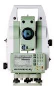
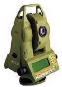
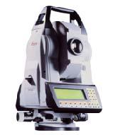
3 Leica s Total Station Functionality Accuracy
4 Leica s Telescope High quality optics Accurate reflector, reflector-less and long range EDM Automated prism finding Automatic Target Recognition (ATR) Power Search (PS) Small and coherent laser spot Emitted Guiding lights (EGL)


5 ATR Emits infra-red light while video-imaging is on Locates reflected light Steers the cross-hair to the lightened spot until the angular offset is less than 50 cc (16 arcsec) Measures angle and distance In case there are more than one reflecting spot, the emitter goes on and off to find the activated prism Emitter on Emitter off
6 Power Search (PS) ATR come in Scanning duration (sec) Plausibility volume: 0.1 upper tolerance limit A foreign object: e.g. traffic sign A foreign object: e.g. traffic sign Received signal Amplitude Target object: a prism Plausibility volume: upper tolerance limit Plausibility volume: lower tolerance limit Target object: a prism Plausibility volume: lower tolerance limit 1m 10m 100m 1000m Distance Distance [m]
7 EDM Current Technologies Time of Flight (TOF) & Phase Shift Time of Flight OK > 500 m but less accurate multi-target realisation, but needs excellent laser coherence (expensive) Phase Shift Difficult > 400 m multi-target realisation not possible (inseparable signals) Highly affected by environmental conditions
8 Leica s EDM Technology - System Analyser Permit accurate (in the mm range) RL measurements to objects over large distances (> 500 m) within few seconds (< 12 sec). Permit identification (and correct surveying) of multiple targets. Permit distance measurements independently of general atmospheric influences, such as, dust, smoke, mist, rain or snowfall, etc. Make on-board distance calibration available which runs simultaneously with the distance measurement to avoid thermal drifts and interrupts of measurement flow.
9 System Analyser Large number of high frequencies (100MHz) are emitted to collect distance information with exclusively high resolution Every frequency contributes to the final result giving high accuracy (λ~1.5m) Sub-mm distance resolution is achievable No time is wasted for ambiguity resolution. Selective w r t hard targets and blind w r t soft targets that have low-pass behaviour: 1 to 5 MHz Large number of frequencies causes redundancy: any interruption in the signal path can be detected and neglected Ultra short laser pulses in sub-nsec range within pulse-trains of 100MHz Energy s emitted at higher harmonics (1GHz) supporting high distance resolution Noise is minimised due to the steepness of the wave
10 System Analyser After sampling the received signals, a merit-function (which is comparative to a time-of-flight signal) is constructed based on using all the incoming signal information Thus, all the information between the EDM and Target is included in a quasi-continuous system Advanced algorithms perform a System Analysis to get the function whose maximum is the sought distance Number of used modulation frequencies depends on the received signal strength At high signal levels 4 frequencies are sufficient At low signal levels up to 10 frequencies are emitted and analysed
11 System Analyser Amplitude D (m)
12 Leica s EDM Accuracy (1) Comparison with an Interferometer: up to 60 meter with a 30 cm step mm 4 2 Le ica TOF 1 TOF 1 w/out off-set TOF 2 TOF 2 w/out off-set Phase Shift P ha s e S hift w/out off-s e t m
13 Leica s EDM Accuracy (2) ISO range measurements; max.dist.: K1 = 500m, K2 = Std. Dev. [mm] K1 Combination K2 Leica TOF1 TOF2 Phase Shift [ppm] PPM value Leica TOF1 TOF2 Phase Shift 0 K1 K2 Combination
14 Range and Speed Range Range [m] Kodak grey card 18% reflective Leica TOF1 TOF2 Phase Shift [m] Kodak grey card 90% reflective Leica TOF1 TOF2 Phase Shift 25 Speed [sec.] Leica TOF1 TOF2 Phase Shift 0 Typical max.

15 New Optomechanical Design Laser Diode 2. Collimation lens 3. Tilted mirror 4. Revolver Wheel 5. Adjustable filter wheel 6. Negative lens 7. Tilted mirror 8. Deflection prism 9. Main objective lens 9 8


16 New Optomechanical Design Movable parts Reflectorless position Calibration position Reflector position It intelligently takes a position that depends on the strength of the reflected laser
17 Design Improvements Thus: Improving optical beam path Due to the reduced number of parts in the optical path Improving beam stability Due to the lack of moving mirrors/lenses and improvements of the geometric coupling Improving the MTF (Modulation Transfer Function) Sharper optical picture/impression for optical sighting through telescope Eliminating the need for user adjustment of the laser beam Allowing no misalignments or deviations between the reflector and reflectorless beam

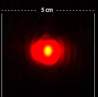
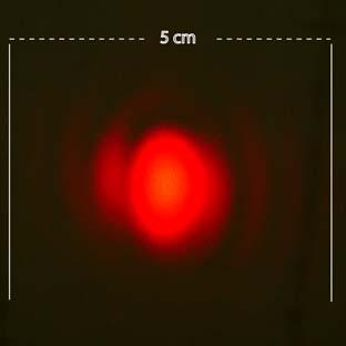
18 Laser Spot 5 m 35 m 55 m
19 Effectiveness of Laser Spot Leica EDM TOF EDM
20 Conclusions Leica s EDM System Analyser is superior to existing technology Able to measure accurate distances with 4 to 6 times lower signals than with a conventional phase-method. Measures routinely to distance > 650 m with maximum time of 12 sec Further investigations are carried out to improve the maximum likelihood approach model in order to measure ranges to more than 1000m on bright diffusive targets. A new optomechanical design that overcomes potential disadvantages found in the old design, especially in terms of beam stability, image quality, laser beam spot geometry, etc.
21 Thank you!
Leica TPS700 Automated Series Increased surveying performance and comfort. PinPoint Technology
 Leica TPS700 Automated Series Increased surveying performance and comfort PinPoint Technology Leica TPS700 Automated Series with automation for more comfort Do you have to solve various surveying tasks
Leica TPS800 Series Powerful, efficient, reliable and intuitive. PinPoint Technology
 Leica TPS800 Series Powerful, efficient, reliable and intuitive PinPoint Technology powerful Leica TPS800 Performance Series... Three classes of accuracy TPS800 total stations are available in angular
Softrock GeoMos Manual For AutoSlope Users
 Softrock GeoMos Manual For AutoSlope Users Software Version 5 Manual Version 1.6 Softrock Solutions specialise in slope monitoring. We have developed software and systems that will assist you with your
Leica FlexLine TS09plus Full Precision at High Performance
 Leica FlexLine TS09plus Full Precision at High Performance The First Plus: Original Leica Geosystems Quality For most, quality is relative. Not so at Leica Geosystems. To ensure our instruments meet the
White Paper. Inside Trimble TX6 and TX8 Deep Dive into Lightning Technology. Prepared by Gregg Jackson and Gregory Lepere ABSTRACT
 White Paper Inside Trimble TX6 and TX8 Deep Dive into Lightning Technology Prepared by Gregg Jackson and Gregory Lepere ABSTRACT With the introduction of next generation Trimble Lightning technology, users
Leica FlexLine TS06plus Top Precision meets High Efficiency
 Leica FlexLine TS06plus Top Precision meets High Efficiency The First Plus: Original Leica Geosystems Quality For most, quality is relative. Not so at Leica Geosystems. To ensure our instruments meet the
LEICA T1800 TC1800 TCA1800
 30 40 50 LEICA T1800 TC1800 TCA1800 Equal to any survey task Theodolites and total stations with 1 accuracy Survey instruments for every task Leica theodolites and total stations of the 1800 class Survey
LEICA TPS700 Performance Series
 LEICA TPS700 Performance Series TPS700 now with automatic for increased surveying performance and comfort LEICA TPS700 Performance Series... Do you have to solve various surveying tasks every day? Would
Leica TDRA6000 Product Brochure
 Leica TDRA6000 Product Brochure Version 01/2009 www.leica-geosystems.com/metrology The Laser Station Leica TDRA6000 The Leica TDRA6000 Laser Station is a portable inspection system designed for precision
Using infrared proximity sensors for close 2D localization and object size recognition. Richard Berglind Neonode
 Using infrared proximity sensors for close 2D localization and object size recognition Richard Berglind Neonode Outline Overview of sensor types IR proximity sensors and their drawbacks Principles of a
Leica Nova MS60 White paper
 Leica Nova MS60 White paper August 2017 Hannes Maar, Hans-Martin Zogg Leica Geosystems AG Heerbrugg, Switzerland leica-geosystems.com Leica Nova MS60 The new experience in measuring technology site which
Critical Aspects when using Total Stations and Laser Scanners for Geotechnical Monitoring
 Critical Aspects when using Total Stations and Laser Scanners for Geotechnical Monitoring Lienhart, W. Institute of Engineering Geodesy and Measurement Systems, Graz University of Technology, Austria Abstract
 MS Series MS05A / MS1A Ultra-high Precision Auto-tracking Total Station n 0.5 / 1 Angular Accuracy n High-Performance, versatile EDM n 0.5 mm Distance Accuracy n Optimised Auto-Pointing n Laser Option
Version 1.0 English. Leica TS15 Quick Guide
 Version 1.0 English Leica TS15 Quick Guide TS15, Important Information about your Instrument 1 Important Information about your Instrument 2 Read and follow the User Manual on the accompanying DVD before
Leica Builder... Built to Build
 Leica Builder... Built to Build Leica Builder... Built to Build Instead of tediously setting up strings, with the Builder T100 my masons can start work right away. The Builder T100 or T200 can determine
MS05AX / MS1AX. MS AX Series. Ultra-high Precision Auto-tracking Total Station
 MS AX Series MS05AX / MS1AX Ultra-high Precision Auto-tracking Total Station n 0.5 / 1 Angle Accuracy n Automated Matrix Detection n High-Performance, versatile EDM n 0.5 mm Distance Accuracy n Laser Option
Leica Builder... Built to Build
 Leica Builder... Built to Build Leica Builder... Built to Build Instead of tediously setting up strings, with the Builder T100 my masons can start work right away. The Builder T100 or T200 can determine
Leica TPS1200 Series High performance Total Station
 Leica TPS1200 Series High performance Total Station Leica TPS1200 Total Stations Packed with exciting new features, built for speed, accuracy, ease-of-use and reliability. Leica TPS1200 Total Stations
Gregory Walsh, Ph.D. San Ramon, CA January 25, 2011
 Leica ScanStation:: Calibration and QA Gregory Walsh, Ph.D. San Ramon, CA January 25, 2011 1. Summary Leica Geosystems, in creating the Leica Scanstation family of products, has designed and conducted
GeoMax Total Station Zoom30 Series
 GeoMax Total Station Zoom30 Series GeoMax About Us GeoMax is an internationally active company developing, manufacturing and distributing quality construction and surveying instruments. We provide a comprehensive
High-End Surveying Precise, Fast and Intelligent. LEICA TPS1100 Professional Series
 High-End Surveying Precise, Fast and Intelligent LEICA TPS1100 Professional Series TPS1100 Professional Series More time for the essentials. Automated, practical programs are the main features of the TPS1100
Agilent 10706B High Stability Plane Mirror Interferometer
 7D Agilent 10706B High Stability Plane Mirror Interferometer Description Description The Agilent 10706B High Stability Plane Mirror Interferometer (see Figure 7D-1) is an improved version of the Agilent
SICK AG WHITEPAPER. LiDAR SENSOR FUNCTIONALITY AND VARIANTS
 SICK AG WHITEPAPER 2018-07 AUTHOR Harald Weber Head of Product Unit Ranging LiDAR sensors at SICK AG in Waldkirch / Germany SUMMARY This white paper explores the many areas in which LiDAR can be applied.
Leica FlexLine TS06plus Top precision meets high efficiency
 Leica FlexLine TS06plus Top precision meets high efficiency The First Plus: Original Leica Geosystems quality For most, quality is relative. Not so at Leica Geosystems. To ensure our instruments meet the
RAILWAY PROJECT Geodetic Reference System, Geodetic Control Network and Rail Construction Measurements
 RAILWAY PROJECT Geodetic Reference System, Geodetic Control Network and Rail Construction Measurements Railway Project 2 / 8 INDEX 1 Introduction... 3 2 Reference System... 3 2.1 Reference system... 3
Leica RX1250 & TPS 1200 Robot
 Leica RX1250 & TPS 1200 Robot Total Station Extended GeoCOM & Firmware Check For FieldGenius to work correctly with your Total Station, Smart Rover and RX1250, Extended GeoCOM must be enabled. This mode
Operation Manual. Autocollimator Test Wedge for quick testing of Electronic Autocollimators
 for quick testing of Electronic Autocollimators For Ident.-No.: 223 244 Version date 05.05.2004 1. Basics The is designed for quick testing of accuracy of electronic autocollimators. If a light beam passes
AUTOMATED 3D STATIONS NET05 NET1
 AUTOMATED 3D STATIONS NET05 NET1 For 3D COORDINATE MEASURING SYSTEM A Giant Leap in the Precision Measurement of Mammoth Structures Since its groundbreaking debut in 1990, SOKKIA s NET series 3D Stations
Solid-State Hybrid LiDAR for Autonomous Driving Product Description
 Solid-State Hybrid LiDAR for Autonomous Driving Product Description What is LiDAR Sensor Who is Using LiDARs How does LiDAR Work Hesai LiDAR Demo Features Terminologies Specifications What is LiDAR A LiDAR
Provided by Xpert Survey Equipment Click Leica TS06 for Product Info and Updated Pricing. Leica FlexLine TS06plus Top precision meets high efficiency
 Provided by Xpert Survey Equipment Click Leica TS06 for Product Info and Updated Pricing Leica TS06plus Top precision meets high efficiency The First Plus: Leica Geosystems quality For most, quality is
Range Sensors (time of flight) (1)
 (1)") Range Sensors (time of flight) (1) Large range distance measurement -> called range sensors Range information: key element for localization and environment modeling Ultrasonic sensors, infra-red sensors
Range Sensors (time of flight) (1) Large range distance measurement -> called range sensors Range information: key element for localization and environment modeling Ultrasonic sensors, infra-red sensors
Adam Hammet & Anthony McClaren. Getting to know the Trimble SX10 Scanning Total Station - Inside and Out ISV Regional Conference 2017: Moama, NSW
 Adam Hammet & Anthony McClaren Getting to know the Trimble SX10 Scanning Total Station - Inside and Out ISV Regional Conference 2017: Moama, NSW Contents Difference between scanner and a Total station
TAKING LIDAR SUBSEA. Adam Lowry, Nov 2016
 TAKING LIDAR SUBSEA Adam Lowry, Nov 2016 3D AT DEPTH Based in the technology hub of Boulder, Colorado, 3D at Depth is dedicated to the development of underwater laser measurement sensors and software Patented
LZR -U920/U921 Protocol
 LZR -U920/U921 Protocol Abbreviations LZR: laser scanner platform ToF: Time-of-Flight MDI: measured distance information 1. Introduction This application note contains useful information for communication
GeoMax Total Station Zoom30 Series
 GeoMax Total Station Zoom30 Series GeoMax About Us GeoMax is an internationally nology group with strong mar- The close cooperation within active company developing, ket positions within measure- the Hexagon
INSTALLATION GUIDE Ultrasonic Sensors Series UFP
 INSTALLATION GUIDE Ultrasonic Sensors Series UFP For further information please see the data sheet at www.waycon.biz/products/ultrasonic-sensors/ FIRST STEPS WayCon Positionsmesstechnik GmbH would like
INSTALLATION GUIDE Ultrasonic Sensors Series UPA
 INSTALLATION GUIDE Ultrasonic Sensors Series UPA For further information please see the data sheet at www.waycon.biz/products/ultrasonic-sensors/ FIRST STEPS WayCon Positionsmesstechnik GmbH would like
GEODETIC MEASURING METHODS AND SHAPE ESTIMATION OF CONCRETE THIN SHELL SURFACE
 GEODETIC MEASURING METHODS AND SHAPE ESTIMATION OF CONCRETE THIN SHELL SURFACE M. Woźniak, K. Woźniak Warsaw University of Technology ABSTRACT The geodetic measurements of surface geometry can be performed
Total Station & Distomat
 UNIT 6 Total Station & Distomat Learning Objectives After studying this unit, the student will be able to Understand the parts of Total station Temporary adjustments of total station Measurement of horizontal
Provided by Xpert Survey Equipment Click Topcon GPT-8003A for Product Info and Updated Pricing GPT-8000A/GTS-810A SERIES AUTO TRACKING TOTAL STATION
 Provided by Xpert Survey Equipment Click Topcon GPT-8003A for Product Info and Updated Pricing GPT-8000A/GTS-810A SERIES AUTO TRACKING TOTAL STATION The Solo Survey System that puts you in control The
Overview of Active Vision Techniques
 SIGGRAPH 99 Course on 3D Photography Overview of Active Vision Techniques Brian Curless University of Washington Overview Introduction Active vision techniques Imaging radar Triangulation Moire Active
Calibration of a portable interferometer for fiber optic connector endface measurements
 Calibration of a portable interferometer for fiber optic connector endface measurements E. Lindmark Ph.D Light Source Reference Mirror Beamsplitter Camera Calibrated parameters Interferometer Interferometer
Leica TPS1200+ Series High performance Total Station
 PointSolutions www.pointsolutions-us.com Leica TPS1200+ Series High performance Total Station Leica TPS1200+ Total Stations Packed with exciting new features, built for speed, accuracy, ease-of-use and
Optical Sensors: Key Technology for the Autonomous Car
 Optical Sensors: Key Technology for the Autonomous Car Rajeev Thakur, P.E., Product Marketing Manager, Infrared Business Unit, Osram Opto Semiconductors Autonomously driven cars will combine a variety
MODULE 1. INTRODUCTION
 MODULE 1. INTRODUCTION Learning Outcomes: This module gives students an overview of electronic distance measurement (EDM) and the role of 3D laser scanning in land surveying as the latest EDM technology.
Provided by Xpert Survey Equipment Click Topcon GPT-8205A for Product Info and Updated Pricing GPT-8200A/GTS-820A SERIES AUTO TRACKING TOTAL STATION
 Provided by Xpert Survey Equipment Click Topcon GPT-8205A for Product Info and Updated Pricing GPT-8200A/GTS-820A SERIES AUTO TRACKING TOTAL STATION The Solo Survey System that puts you in control The
GEOMETRICAL SURVEY OF COMPACT ANTENNA TEST RANGES USING LASER TRACKER TECHNOLOGY
 GEOMETRICAL SURVEY OF COMPACT ANTENNA TEST RANGES USING LASER TRACKER TECHNOLOGY Manfred Juretzko and Eva Richter Geodätisches Institut Universität Karlruhe Email: juretzko@gik.uni-karlsruhe.de Abstract:
Electronic angle measuring machine. Angle/position by means of vignetting
 OPTIK MESS- UND PRÜFTECHNIK VERTRIEB BERATUNG TRAINING ELWIMAT Electronic angle measuring machine WiPoVi Angle/position by means of vignetting Biaxial optical angle measuring with great measuring range
ACTA TECHNICA CORVINIENSIS Bulletin of Engineering Tome X [2017] Fascicule 2 [April June] ISSN:
![ACTA TECHNICA CORVINIENSIS Bulletin of Engineering Tome X [2017] Fascicule 2 [April June] ISSN:](/thumbs/88/117280512.jpg "ACTA TECHNICA CORVINIENSIS Bulletin of Engineering Tome X [2017] Fascicule 2 [April June] ISSN:") Tome X [2017] Fascicule 2 [April June] ISSN: 2067 3809 1. Yung-Cheng WANG, 2. Bean-Yin LEE, 1. Chih-Hao HUANG, 3. Chi-Hsiang CHEN DEVELOPMENT OF THE AXIAL PRECISION INSPECTION SYSTEM FOR SPINDLES IN TOOL
Tome X [2017] Fascicule 2 [April June] ISSN: 2067 3809 1. Yung-Cheng WANG, 2. Bean-Yin LEE, 1. Chih-Hao HUANG, 3. Chi-Hsiang CHEN DEVELOPMENT OF THE AXIAL PRECISION INSPECTION SYSTEM FOR SPINDLES IN TOOL
ZED Tunnel Guidance Ltd
 Tunnel Guidance Ltd Unit 1, Russell House, Molesey Road, Walton-on-Thames, Surrey, KT12 3PJ, UK. Telephone: +44 (0)1932 251 440 Email: sales@zed-tg.co.uk Fax: +44 (0)1932 244 971 Website: http://www.zed-tg.co.uk
1. PRECAUTIONS. Thank you for choosing RUIDE theodolite Disteo 23. Please read this manual carefully before use.
 Thank you for choosing RUIDE theodolite Disteo 23. Please read this manual carefully before use. 1. PRECAUTIONS a. Do not collimate the objective lens directly to the sunlight without a filter. b. Do not
Outline Sensors. EE Sensors. H.I. Bozma. Electric Electronic Engineering Bogazici University. December 13, 2017
 Electric Electronic Engineering Bogazici University December 13, 2017 Absolute position measurement Outline Motion Odometry Inertial systems Environmental Tactile Proximity Sensing Ground-Based RF Beacons
Leica TPS1200 Series High performance Total Station
 Leica TPS1200 Series High performance Total Station Leica TPS1200 Total Stations Packed with exciting new features, built for speed, accuracy, ease-of-use and reliability. Leica TPS1200 Total Stations
Version 2.0 English. Leica FlexLine TS02/TS06/TS09 Quick Guide
 Version 2.0 English Leica FlexLine TS02/TS06/TS09 Quick Guide To use the product in a permitted manner, please refer to the detailed safety instructions in the User Manual. Container Contents a b c d e
Increase Field Survey Efficiency by Merging Technologies in NOVA MultiStation. Vincent Lui Leica Geosystems Ltd
 Increase Field Survey Efficiency by Merging Technologies in NOVA MultiStation Vincent Lui Leica Geosystems Ltd Advantages of Laser Scanning Advantages of TPS Measurements Advantages of Imaging Advantages
Leica TS11 Quick Guide. Version 2.0 English
 Leica TS11 Quick Guide Version 2.0 English TS11, Important Information about your Instrument 1 Important Information about your Instrument 2 Read and follow the User Manual on the accompanying DVD before
Keyboard and display configurations may vary.
 Keyboard and display configurations may vary. Because it's the time spent between points that's important Superior reflectorless distance measurement Higly reliable remote controle Saving time and energy
10/5/09 1. d = 2. Range Sensors (time of flight) (2) Ultrasonic Sensor (time of flight, sound) (1) Ultrasonic Sensor (time of flight, sound) (2) 4.1.
 (2) Ultrasonic Sensor (time of flight, sound) (1) Ultrasonic Sensor (time of flight, sound) (2) 4.1.") Range Sensors (time of flight) (1) Range Sensors (time of flight) (2) arge range distance measurement -> called range sensors Range information: key element for localization and environment modeling Ultrasonic
Range Sensors (time of flight) (1) Range Sensors (time of flight) (2) arge range distance measurement -> called range sensors Range information: key element for localization and environment modeling Ultrasonic
Roll angle in 6DOF tracking. CMSC Charlotte-Concord, July 2008
 Roll angle in 6DOF tracking CMSC Charlotte-Concord, July 2008 Author: Stephen Kyle Senior honorary research fellow, University College London Honorary research fellow, Coventry University Presenter: Steven
Single-Axis Lasers for Flatness and Leveling Applications. Laser Systems for Flatness and Leveling L-730/L-740 Series
 Single-Axis Lasers for Flatness and Leveling Applications Laser Systems for Flatness and Leveling L-730/L-740 Series Why the L-730/L-740 Flatness Leveling Systems are Better Sooner or later everything
Lecture Outline Chapter 26. Physics, 4 th Edition James S. Walker. Copyright 2010 Pearson Education, Inc.
 Lecture Outline Chapter 26 Physics, 4 th Edition James S. Walker Chapter 26 Geometrical Optics Units of Chapter 26 The Reflection of Light Forming Images with a Plane Mirror Spherical Mirrors Ray Tracing
TriAngle. Electronic Autocollimators for Precise Angle Measurement
 TriAngle Electronic Autocollimators for Precise Angle Measurement Angle Measurement Solutions Contents Page TriAngle Angle Measurement Solutions 3 Operating Principle 4 TriAngle Product Range 5 Highly
Ray Optics I. Last time, finished EM theory Looked at complex boundary problems TIR: Snell s law complex Metal mirrors: index complex
 Phys 531 Lecture 8 20 September 2005 Ray Optics I Last time, finished EM theory Looked at complex boundary problems TIR: Snell s law complex Metal mirrors: index complex Today shift gears, start applying
Leica Geosystems Original Accessories The right selection
 Leica Geosystems Original Accessories The right selection Original Accessories Become the best surveyor with Leica Geosystems equipment Designed and built to the most stringent standards, Leica Geosystems
Developments in Dimensional Metrology in X-ray Computed Tomography at NPL
 Developments in Dimensional Metrology in X-ray Computed Tomography at NPL Wenjuan Sun and Stephen Brown 10 th May 2016 1 Possible factors influencing XCT measurements Components Influencing variables Possible
PCMM System Specifications Leica Absolute Tracker and Leica T-Products
 www.leica-geosystems.com/metrology PCMM System Specifications Leica Absolute Tracker and Leica T-Products Leica Absolute Tracker accuracy The measurement uncertainty of a coordinate U xyz is defined as
Leica Geosystems Original Accessories The right selection
 Leica Geosystems Original Accessories The right selection Original Accessories Become the best surveyor with Leica Geosystems equipment Designed and built to the most stringent standards, Leica Geosystems
THE MOST FLEXIBLE INSTRUMENTATION FOR SURVEYING AND ALIGNMENT - A HIGH PRECISION TOTAL STATION CONTROLLED BY MODERN SOFTWARE
 III/296 THE MOST FLEXIBLE INSTRUMENTATION FOR SURVEYING AND ALIGNMENT - A HIGH PRECISION TOTAL STATION CONTROLLED BY MODERN SOFTWARE Holger Wirth Metronom, Gesellschaft für Industrievermessung mbh, Mainz,
PCMM System Specifications Leica Absolute Tracker and Leica T-Products
 www.leica-geosystems.com/metrology PCMM System Specifications Leica Absolute Tracker and Leica T-Products Leica Absolute Tracker accuracy Feature Benefit The measurement uncertainty of a coordinate U xyz
Laser RangeFinders. Hamed Lotfizad Mehdi Modaresi Professor.. ...Dr. H.Tagirad
 Laser RangeFinders Hamed Lotfizad......791210122 Mehdi Modaresi.791210125 Professor.....Dr H.Tagirad The Invention of the Laser The Invention of the Laser Invented in 1958 by Charles Townes and Arthur
Integrating the Generations, FIG Working Week 2008,Stockholm, Sweden June 2008
 H. Murat Yilmaz, Aksaray University,Turkey Omer Mutluoglu, Selçuk University, Turkey Murat Yakar, Selçuk University,Turkey Cutting and filling volume calculation are important issues in many engineering
HIGH PRECISION SURVEY AND ALIGNMENT OF LARGE LINEAR COLLIDERS - HORIZONTAL ALIGNMENT -
 HIGH PRECISION SURVEY AND ALIGNMENT OF LARGE LINEAR COLLIDERS - HORIZONTAL ALIGNMENT - A. Herty, J. Albert 1 Deutsches Elektronen-Synchrotron DESY, Hamburg, Germany with international partners * 1. INTRODUCTION
Advanced Highway Maintenance and Construction Technology Research Center
 Advanced Highway Maintenance and Construction Technology Research Center Department of Mechanical and Aerospace Engineering University of California at Davis Creating Standards and Specifications for the
1. Motivation 2. Nanopositioning and Nanomeasuring Machine 3. Multi-Sensor Approach 4. Conclusion and Outlook
 Prospects of multi-sensor technology for large-area applications in micro- and nanometrology 08/21/2011-08/25/2011, National Harbor E. Manske 1, G. Jäger 1, T. Hausotte 2 1 Ilmenau University of Technology,
TERRESTRIAL LASER SYSTEM TESTING USING REFERENCE BODIES
 TERRESTRIAL LASER SYSTEM TESTING USING REFERENCE BODIES Miriam Zámečníková and Alojz Kopáčik Department of Surveying, Faculty of Civil Engineering Slovak University of Technology Email: miriam.zamecnikova@stuba.sk
Geomagic Leica Tracker Plug-In 1.0 User s Manual
 Geomagic Leica Tracker Plug-In 1.0 User s Manual Document version 1.0.1 Overview The Geomagic Leica Tracker Plug-In supports the Leica AT901 Laser Tracker in Geomagic Qualify, Geomagic Qualify Probe, Geomagic
Alignment Services LLC
 Alignment Services LLC Accuracy and Portability Laser Tracker IIPLUS!TM Laser Tracker II PLUS! surpasses the performance, portability, and accuracy of previous tracker technology. Laser Tracker IIPLUS!
Chapter 26 Geometrical Optics
 Chapter 26 Geometrical Optics 1 Overview of Chapter 26 The Reflection of Light Forming Images with a Plane Mirror Spherical Mirrors Ray Tracing and the Mirror Equation The Refraction of Light Ray Tracing
Time of Flight: Principles, Challenges, and Performance. ST Technology Tour 2017 John Kvam
 Time of Flight: Principles, Challenges, and Performance ST Technology Tour 2017 John Kvam Agenda 2 Time of Flight Principles and Design Choices Performance Application Examples Design Challenges Calibration
GeoMax TPS family. Works when you do.
 Works when you do GeoMax TPS family GeoMax has a complete TPS portfolio to fulfill the needs of all users. Ensure ultimate reliability with GeoMax TPS systems even in challenging environments. Providing
Leica Viva SmartWorx Viva on TS
 Leica Viva SmartWorx Viva on TS Contents 2. Volumes 3. Check & Adjust 4. CS Connection Wizard 5. Robotic Screen 6. Summary 2 Contents 2. Volumes 3. Check & Adjust 4. CS Connection Wizard 5. Robotic Screen
LAS extrabytes implementation in RIEGL software WHITEPAPER
 in RIEGL software WHITEPAPER _ Author: RIEGL Laser Measurement Systems GmbH Date: May 25, 2012 Status: Release Pages: 13 All rights are reserved in the event of the grant or the registration of a utility
Sensor Modalities. Sensor modality: Different modalities:
 Sensor Modalities Sensor modality: Sensors which measure same form of energy and process it in similar ways Modality refers to the raw input used by the sensors Different modalities: Sound Pressure Temperature
New Technologies For The Real 3D Reference Point Determination
 New Technologies For The Real 3D Reference Point Determination Maria Hennes, Cornelia Eschelbach GIK, Geodetic Institute of the University of Karlsruhe, Germany Contact author: Maria Hennes, e-mail: hennes@gik.uni-karlsruhe.de
Level 6 Graduate Diploma in Engineering Engineering surveying
 9210-104 Level 6 Graduate Diploma in Engineering Engineering surveying Sample Paper You should have the following for this examination answer booklets non-programmable calculator pens, pencils, drawing
Traditional pipeline for shape capture. Active range scanning. New pipeline for shape capture. Draw contours on model. Digitize lines with touch probe
 Traditional pipeline for shape capture Draw contours on model Active range scanning Digitize lines with touch probe Fit smooth surfaces CAD/CAM Texturing and animation 1 2 New pipeline for shape capture
Practical Robotics (PRAC)
") Practical Robotics (PRAC) A Mobile Robot Navigation System (1) - Sensor and Kinematic Modelling Nick Pears University of York, Department of Computer Science December 17, 2014 nep (UoY CS) PRAC Practical
Practical Robotics (PRAC) A Mobile Robot Navigation System (1) - Sensor and Kinematic Modelling Nick Pears University of York, Department of Computer Science December 17, 2014 nep (UoY CS) PRAC Practical
Leica FlexLine plus. Product Presentation V4.00
 Leica FlexLine plus Product Presentation V4.00 Leica FlexLine plus Table of contents 1. FlexLine plus - Product Concept 2. FlexLine plus - Hardware Features 3. FlexField plus - Onboard Firmware 4. FlexLine
AUTOMATIC DETERMINATION OF FOREST INVENTORY PARAMETERS USING TERRESTRIAL LASER SCANNING
 AUTOMATIC DETERMINATION OF FOREST INVENTORY PARAMETERS USING TERRESTRIAL LASER SCANNING Merlijn Simonse 1, Tobias Aschoff, Heinrich Spiecker 3 and Michael Thies 4 Albert Ludwigs University, Institute for
Sensor technology for mobile robots
 Laser application, vision application, sonar application and sensor fusion (6wasserf@informatik.uni-hamburg.de) Outline Introduction Mobile robots perception Definitions Sensor classification Sensor Performance
Chapter 32 Light: Reflection and Refraction. Copyright 2009 Pearson Education, Inc.
 Chapter 32 Light: Reflection and Refraction Units of Chapter 32 The Ray Model of Light Reflection; Image Formation by a Plane Mirror Formation of Images by Spherical Mirrors Index of Refraction Refraction:
ROFIN SWS. Scanner Welding System Highly dynamic and robotically guided.
 LASER MACRO ROFIN SWS Scanner Welding System Highly dynamic and robotically guided. T H E P O W E R O F L I G H T ROFIN SWS THE PRODUCT 3D Scanner Welding on the Fly The Scanner Welding System (SWS) is
Keyboard and display configurations may vary.
 Keyboard and display configurations may vary. Because it's the time spent between points that's important. Stress-Free Complete Remote Control RED-tech EX - Precise Distance Measurement over a Wide Range
STRAIGHT LINE REFERENCE SYSTEM STATUS REPORT ON POISSON SYSTEM CALIBRATION
 STRAIGHT LINE REFERENCE SYSTEM STATUS REPORT ON POISSON SYSTEM CALIBRATION C. Schwalm, DESY, Hamburg, Germany Abstract For the Alignment of the European XFEL, a Straight Line Reference System will be used
Calibration of the LIGO Interferometer Using the Recoil of Photons
 Calibration of the LIGO Interferometer Using the Recoil of Photons Justice Bruursema Mentor: Daniel Sigg Motivation The Photon Calibrator has been developed to provide a physically independent means of
COMPACT RANGE CALIBRATION AND ALIGNMENT
 COMPACT RANGE CALIBRATION AND ALIGNMENT M. Juretzko and E. Richter Geodetic Institute, University of Karlsruhe, 76128 Karlsruhe, Germany juretzko@gik.uni-karlsruhe.de richter@gik.uni-karlsruhe.de M. Paquay
Aligning Parallelism of Rolls Has Never Been Faster. L-732 Precision Dual-Scan Roll Alignment System
 Aligning Parallelism of Rolls Has Never Been Faster L-732 Precision Dual-Scan Roll Alignment System Why the L-732 Roll Alignment System is Better Roll parallelism accuracy of.00018 in/ft (0.015 mm/m) Up
Acuity. Acuity Sensors and Scanners. Product Brochure
 Acuity Acuity Sensors and Scanners Product Brochure CCS PRIMA The CCS Prima series of confocal displacement sensors are amongst the most precise measuring instruments in the world. Using a confocal chromatic
Software for Land Development Professionals
 Software for Land Development Professionals SurvNET Carlson SurvNET is SurvCADD's Network Least Squares Reduction (NLSA) program. This module will perform a least squares adjustment and statistical analysis
Straightness measurement
 Page 1 of 45 Straightness measurement User guide This manual is available in English only 2000-2001 Renishaw - 8 August 2001 Issue 5.1 Procedure for performing straightness measurement Straightness measurements