Increase Field Survey Efficiency by Merging Technologies in NOVA MultiStation. Vincent Lui Leica Geosystems Ltd
|
|
|
- Cleopatra Thornton
- 5 years ago
- Views:
Transcription


1 Increase Field Survey Efficiency by Merging Technologies in NOVA MultiStation Vincent Lui Leica Geosystems Ltd

2 Advantages of Laser Scanning Advantages of TPS Measurements Advantages of Imaging Advantages of GNSS Connectivity
3 Leica Nova MS50 MultiStation Overview 1 Angle Accuracy Remote connection WLAN / Bluetooth Servofocus Wheel IP65 environmental protection USB/RS232 Lemo Port Battery charging functionality Overview Camera (5 Mpix) 20Hz live video stream Telescope Camera (5 Mpix) Autofocus 2000m reflectorless EDM (wave form digitizer) Piezo Direct Drives SmartWorx Viva onboard incl. 3D point cloud processing 3
4 Leica Nova MS50 Imaging change the way you work on Total Station 4

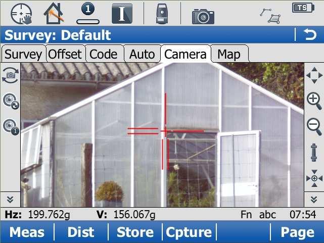
5 Leica Nova MS50 Imaging 5
6 Leica Nova MS50 Super EDM Super EDM Reflectorless up to 2000m (2 4mm + 2ppm) Auto Target Reorganization (ATR) No need for human aiming to target, high & consistent accuracy Power Search and auto target locking One man surveying 6

7 Leica Nova MS50 Laser Scanning 3D laser scanning functionality: Scan range up to 1000m 1000 pts/sec up to 300m mm level scan precision On-board auto point cloud viewing and registration Images High resolution images overlay 3D point cloud RGB, Intensity display of point cloud 7
8 Leica Nova MS50 Scanning Use standard TPS setup routines as e.g. resection, know backsight, NO «Registration» of point clouds in post processing needed Registration is already done in field Setup 2 Setup 1 8


9 Leica Nova MS50 Scanning Example of scanning a house Setup 1 Setup 2 9


10 Viewing 3D point cloud onboard Scanning 3D point cloud viewer onboard Viewing point clouds from different instrument setups Single colour, RGB and intensity colouring Verification of scan data directly in the field Check completeness of scan 10
 Internal memory SD-card USB-stick USB Field Office 3rd party SW & CAD solutions Process TPS")

11 Leica Nova MS50 Data flow Basic in-the-field Processing (e.g. Volumes) Internal memory SD-card USB-stick USB Field Office 3rd party SW & CAD solutions Process TPS and Scanning data Leica Infinity Manage / Combine / (Re-) Process Scanning Application Results Cyclone/CloudWorx Point Clouds for post-processing Leica MultiWorx AutoCad PlugIn for simple point cloud processing GeoMos Point Clouds for Analysis In monitoring applications 11
12 Leica Nova MS50 Example Applications. 12
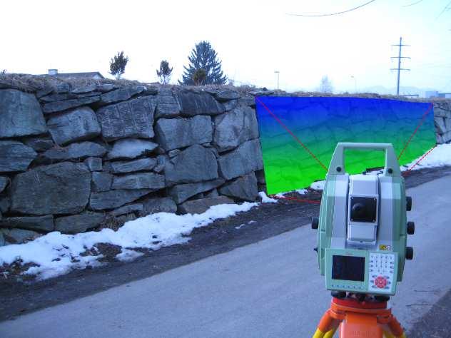
13 Example Application Façade Scan. 13
14 Example Application Façade Scan. (Demo video) 14
15 Example Application Façade Scan Benefits. Create deliverables quicker than standard Total Station Improve delivered information Reduce errors Measure in the office / Sharing result over Internet 15
16 Example Application Simple Object Modelling. 16
17 Example Application Simple Object Modelling. (Demo video) 17

18 Example Application Simple Object Modelling sharing result by TruView. 18
19 Example Application Simple Object Modelling Benefits. Create deliverables quicker than regular Total Station Reduce errors, thanks to automatic point cloud registration Open new opportunities for business Measure in the office / Sharing result over Internet
20 Example Application Volume and Area Measurement 20
21 Example Application Volume and Area Measurement (Demo Video) 21
22 Example Application Monitoring. 22
23 Example Application Monitoring. (Demo video) 23
24 Leica GeoMoS Scanning with MS50 General First-ever automatic scanning solution in an integrated monitoring system Free Station (geo-referencing) combined with multiple scan areas 24
25 Leica GeoMoS Scanning How it works? Scan wizard for configuration Take image to posit MS50 to area of interest (Wide Angle Camera or 30x Tele Camera) Polygon to define scan area Scan properties Image assisted remote learning of scan areas, even from the office 25
26 Leica GeoMoS Scanning How it works? Create Null Epoch as reference for monitoring Start Scan one or multiple times under good conditions Merge scans to Null Epoch 3D Visualization of Null Epoch Add final scan area to the automatic measurement cycle and define the measurement interval 26
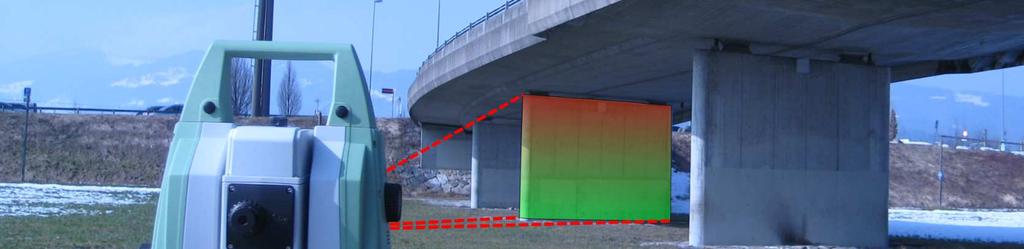
27 Leica GeoMoS Scanning How it works? New nvec Technology for cloud processing in deformation monitoring Automatic process, No operator 24/7 running system, continuous cloud production Simple requirement: display change of the color when deformation is detected on the object deformation volume 27
28 Leica GeoMoS Scanning How it works? Impressive result out of points, 300m, 0.5m spacing Result is linked to high resolution image Max. Deformation Vector to distribute warning over , SMS Deformation volume [m3] Slider to check historic data 28
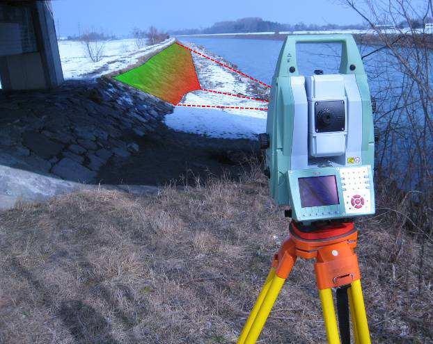
29 Example Application Monitoring structures e.g. Bridges, Slope, Dams 29

30 Example Application Monitoring Pipes in Plants. 30

31 Example Application Monitoring Cooling Towers. 31
32 Example Application Monitoring Benefits. Full monitoring coverage - combining scans and images with prism monitoring Extend information and situation control - highest monitoring density by measuring surfaces between the prisms Fully integrated - Automated scanning process in geodetic and geotechnical monitoring 32
33 Example Application Monitoring Benefits. Image assisted remote learning and easy configuration of scan areas, even from the office Easy upgrade of existing monitoring installations with scanning Automatic reporting & status alert 33
34 Thank you for your attention! 34
Leica Nova MS60 White paper
 Leica Nova MS60 White paper August 2017 Hannes Maar, Hans-Martin Zogg Leica Geosystems AG Heerbrugg, Switzerland leica-geosystems.com Leica Nova MS60 The new experience in measuring technology site which
Leica Viva TS11 & TS15 Hardware
 Leica Viva TS11 & TS15 Hardware Contents 1. Introduction 2. Product Variants 3. Side Cover 4. Display and Keyboard 5. Environmental Rating 6. Telescope 8. Operating System & Software 9. Summary 1. Introduction
Leica FlexLine TS09plus Full Precision at High Performance
 Leica FlexLine TS09plus Full Precision at High Performance The First Plus: Original Leica Geosystems Quality For most, quality is relative. Not so at Leica Geosystems. To ensure our instruments meet the
Leica ScanStation C10 The All-in-One Laser Scanner for Any Application
 The All-in-One Laser Scanner for Any Application Versatility, Productivity, Value Many organizations interested in laser scanning to diversify and/or improve current business have been waiting for a scanner
Leica Viva SmartWorx Viva on TS
 Leica Viva SmartWorx Viva on TS Contents 2. Volumes 3. Check & Adjust 4. CS Connection Wizard 5. Robotic Screen 6. Summary 2 Contents 2. Volumes 3. Check & Adjust 4. CS Connection Wizard 5. Robotic Screen
Leica FlexLine TS06plus Top Precision meets High Efficiency
 Leica FlexLine TS06plus Top Precision meets High Efficiency The First Plus: Original Leica Geosystems Quality For most, quality is relative. Not so at Leica Geosystems. To ensure our instruments meet the
Leica FlexLine TS06plus Top precision meets high efficiency
 Leica FlexLine TS06plus Top precision meets high efficiency The First Plus: Original Leica Geosystems quality For most, quality is relative. Not so at Leica Geosystems. To ensure our instruments meet the
Viva TPS. TS11/15 Total Stations Connect the CS Controller and TS15 with Bluetooth. October Summary
 Viva TPS October 2010 TS11/15 Total Stations Connect the CS Controller and TS15 with Bluetooth Summary This guide will show how to connect the TS instrument and CS controller for wireless operation by
GeoMax TPS family. Works when you do.
 Works when you do GeoMax TPS family GeoMax has a complete TPS portfolio to fulfill the needs of all users. Ensure ultimate reliability with GeoMax TPS systems even in challenging environments. Providing
Terrestrial 3D laser scanning Practical aspects
 Terrestrial 3D laser scanning Practical aspects ISPRS WG VI/5&SC Summer School 2007 by Gregor Bilban 3D laser scanning Benefits Lower data collection costs Reduction or elimination of re-visits More accurate
Evidence Recorder Release Notes
 Evidence Recorder 6.0.0 Release Notes Released on: October 5, 2009 Licensing Changes This release has had one big change and that is a new licensing system that gives us more flexibility to add different
Provided by Xpert Survey Equipment Click Leica TS06 for Product Info and Updated Pricing. Leica FlexLine TS06plus Top precision meets high efficiency
 Provided by Xpert Survey Equipment Click Leica TS06 for Product Info and Updated Pricing Leica TS06plus Top precision meets high efficiency The First Plus: Leica Geosystems quality For most, quality is
Leica FlexLine plus. Product Presentation V4.00
 Leica FlexLine plus Product Presentation V4.00 Leica FlexLine plus Table of contents 1. FlexLine plus - Product Concept 2. FlexLine plus - Hardware Features 3. FlexField plus - Onboard Firmware 4. FlexLine
Leica ScanStation C5 Scalable Laser Scanner
 Leica ScanStation C5 Scalable Laser Scanner Leica ScanStation C5 Scalable from the Start Companies entering into laser scanning are often faced with inflexible and complex situations and would like a scalable
Softrock GeoMos Manual For AutoSlope Users
 Softrock GeoMos Manual For AutoSlope Users Software Version 5 Manual Version 1.6 Softrock Solutions specialise in slope monitoring. We have developed software and systems that will assist you with your
GeoMax Total Station Zoom30 Series
 GeoMax Total Station Zoom30 Series GeoMax About Us GeoMax is an internationally active company developing, manufacturing and distributing quality construction and surveying instruments. We provide a comprehensive
Streamline your office to field processes. Peter Madsen
 2017 Streamline your office to field processes Peter Madsen Introduction Improving your office>field>office workflows and processes Data Preparation Data Upload Field Process Coding / Stringing Object
Leica Geosystems TPS
 Leica Geosystems TPS Leica Geosystems Total Stations Semiprofessional Basic TS15 TS50 MS50 TM50 TS11 Monitoring ScanStation TS09 plus TS06 plus Professional TS02 plus Flexline Leica FlexLine plus Product
Our Challenge : To manage an increasingly complex world!
 SmartPhones Our Challenge : To manage an increasingly complex world! The Leica Response: To enable the capture, and virtualisation of this complex world quickly, easily and accurately New hardware and
For construction levelling. Jogger 20: #LG762263, Jogger 24: #LG762264, Jogger 28: #LG783739, Jogger 32: #LG783740
 2017 18 CATALOGUE Automatic Levels Pentax AP-200 Rugged and dependable, ideal for engineering and construction use. AP224: #TBA, AP228: #TBA AP230: #TBA, AP241: #TBA - 20, 24 or 28x magnification - Short
BIM & Digital Transformation Scotland Live 2018 Capturing 3D Reality at the push of a button
 BIM & Digital Transformation Scotland Live 2018 Capturing 3D Reality at the push of a button Gary Kelly Country Manager Scotland Leica Geosystems @LeicaScot Capturing 3D Reality at the push of a button
Product Leica Geo Office 8.2 Date October 26th, 2011
 Product Leica Geo Office 8.2 Date October 26th, 2011 Leica Geosystems AG Heinrich-Wild-Strasse CH-9435 Heerbrugg Switzerland 1 About this Release LEICA GEO OFFICE VERSION 8.2 LEICA Geo Office (LGO) is
Leica TPS700 Automated Series Increased surveying performance and comfort. PinPoint Technology
 Leica TPS700 Automated Series Increased surveying performance and comfort PinPoint Technology Leica TPS700 Automated Series with automation for more comfort Do you have to solve various surveying tasks
Foreword. Robert Kennedy Director
 2014 2015 CATALOGUE Foreword Founded in 1934, C.R.Kennedy & Company has grown to become Australia s largest supplier of surveying instrument in Australia by dollar value. We are proud to represent many
Reality Capture using: RPAS Technologies & Image Laser Scanners
 Reality Capture using: RPAS Technologies & Image Laser Scanners by Johan Erasmus (RPAS Technologies) & Barend Bornman (Image Laser Scanners) from Aciel Geomatics Laser Scanners High-Definition Surveying
GeoMax Total Station Zoom30 Series
 GeoMax Total Station Zoom30 Series GeoMax About Us GeoMax is an internationally nology group with strong mar- The close cooperation within active company developing, ket positions within measure- the Hexagon
Leica TDRA6000 Product Brochure
 Leica TDRA6000 Product Brochure Version 01/2009 www.leica-geosystems.com/metrology The Laser Station Leica TDRA6000 The Leica TDRA6000 Laser Station is a portable inspection system designed for precision
Critical Aspects when using Total Stations and Laser Scanners for Geotechnical Monitoring
 Critical Aspects when using Total Stations and Laser Scanners for Geotechnical Monitoring Lienhart, W. Institute of Engineering Geodesy and Measurement Systems, Graz University of Technology, Austria Abstract
Leica Viva Imaging Enrich your Surveying Workflow
 Leica Viva Imaging Enrich your Surveying Workflow Your Vision: Images that Welcome to Leica Viva Imaging Enrich your Surveving Workflow Leica Viva Imaging enriches your surveying workflow with visual documentation
LEICA TPS700 Performance Series
 LEICA TPS700 Performance Series TPS700 now with automatic for increased surveying performance and comfort LEICA TPS700 Performance Series... Do you have to solve various surveying tasks every day? Would
Leica FlexField plus & Leica FlexOffice A Perfect Match
 Leica FlexField & Leica FlexOffice A Perfect Match FlexField Onboard Software General File Management Data Import Data Export Status icon bar Instrument Protection with PIN Stake Out beep Map Select Programs
Leica DISTO X4 Designed for bright, outdoor environments
 Leica DISTO X4 Designed for bright, outdoor environments Pointfinder camera The DISTO X4 is equipped with a Pointfinder camera allowing you to easily target distant objects in bright sunlight. Even if
Leica RX1250 & TPS 1200 Robot
 Leica RX1250 & TPS 1200 Robot Total Station Extended GeoCOM & Firmware Check For FieldGenius to work correctly with your Total Station, Smart Rover and RX1250, Extended GeoCOM must be enabled. This mode
Trimble Survey Controller. Release Notes
 Trimble Survey Controller Release Notes Version 10.5 Revision A September 2002 Corporate Office Trimble Navigation Limited Engineering and Construction Division 5475 Kellenburger Road Dayton, Ohio 45424-1099
Leica TPS1200 Series High performance Total Station
 Leica TPS1200 Series High performance Total Station Leica TPS1200 Total Stations Packed with exciting new features, built for speed, accuracy, ease-of-use and reliability. Leica TPS1200 Total Stations
icon office release of version
 Product: icon office Date: 17.12.2019 From: Torgny Israelsson icon office release of version 2019.1.11.20 We are pleased to announce the release of icon office 2019. icon office is now available as 64-bit
Leica TPS1200+ Series High performance Total Station
 PointSolutions www.pointsolutions-us.com Leica TPS1200+ Series High performance Total Station Leica TPS1200+ Total Stations Packed with exciting new features, built for speed, accuracy, ease-of-use and
Evaluation of State of the Art Methods for Surface Monitoring of Earth Filled Dams
 Evaluation of State of the Art Methods for Surface Monitoring of Earth Filled Dams W. Lienhart, S. Lackner Institute of Engineering Geodesy and Measurement Systems Graz University of Technology Graz, Austria
Leica Viva TPS October 2010
 Leica Viva TPS TS11/15 CS10/15 Summary Firmware is software that is embedded in a piece of hardware. More or less it is software for hardware. Leica regularly releases updated firmware to improve performance
Leica FlexLine Equipment List
 Leica FlexLine Equipment List FlexLine Equipment List TS02 Instruments Total Stations for Prism Measurements 765268 TS02, 3"(1mgon) total station, laser plummet, 1 standard keyboard, user manual 765265
Leica Campus Knowledge at your Fingertips
 Leica Campus Knowledge at your Fingertips Training Schedule 2010 1 Leica Campus Training Schedule 2010 Leica Campus Training Packages offers flexible courses designed to suit your company s needs and the
Leica Public Safety Solutions Versatile. Durable. Admissible
 Leica Public Safety Solutions Versatile. Durable. Admissible Public Safety Solutions 3D Laser Scanners Software Training and Consulting Services Leica ScanStation PS Series Professional Grade 3D Laser
Leica Captivate. Software Release Notes. Field Controllers: CS20, CS35 Total Stations: TS16, TS60, MS60. Release date 5 th March 2018
 Leica Captivate v3.20 Software Release Notes Product Leica Captivate Field Controllers: CS20, CS35 Total Stations: TS16, TS60, MS60 Release date 5 th March 2018 Maintenance date 5 th March 2018 Available
Product Leica Infinity. Date Nov 30 th, From Kevin Hanson
 Product Leica Infinity Date Nov 30 th, 2017 From Kevin Hanson Leica Geosystems AG Heinrich-Wild-Strasse CH-9435 Heerbrugg Switzerland www.leica-geosystems.com Table of Contents 1 About this Release...
Leica High-Definition Surveying Systems. Leica HDS3000. The Industry Standard for High-Definition Surveying
 Leica High-Definition Surveying Systems Leica HDS3000 The Industry Standard for High-Definition Surveying HDS High-Definition Surveying TM : Laser Scanning Redefined High-Definition Surveying, or HDS,
The Leica HDS Family. The Right Tool for the Job HDS3000 HDS2500 HDS4500. Cyclone & CloudWorx. Press the QuickScan button to define the field-of-view.
 HDS2500 High accuracy scanner, ideal for fixed or raised installations when leveled tripod mounting is not practical, or areas with less stringent field-of-view requirements. The Leica HDS Family Time-of-flight
Presentation Overview
 Stringless Concrete Paving STRINGLESS CONCRETE PAVING ACPA BUS TOUR AUGUST 5, 2015 Presentation Overview 1) Manufactures 2) Components needed for Stringless Paving 3) Conventional Methods VS Stringless
SmartWorx Viva How to Record Static Observation Data On-Board GS Receivers Operating in Base Mode
 SmartWorx Viva How to Record Static Observation Data On-Board GS Receivers Operating in Base Mode Firmware Version 4.03 AUG12 The Viva system provides many options that improve on needed hardware in the
Leica TPS800 Series Powerful, efficient, reliable and intuitive. PinPoint Technology
 Leica TPS800 Series Powerful, efficient, reliable and intuitive PinPoint Technology powerful Leica TPS800 Performance Series... Three classes of accuracy TPS800 total stations are available in angular
Leica DISTO S910 Measure point data and create plans
 Leica DISTO S910 Measure point data and create plans The world s first Measure anything from anywhere with P2P Technology It s been over 20 years since Leica Geosystems launched the first hand-held laser
Leica Captivate. Software Release Notes. Field Controllers: CS20, CS35 Total Stations: TS16, TS60, MS60. Release date 1 st December 2017
 Leica Captivate v3.00 Software Release Notes Product Leica Captivate Field Controllers: CS20, CS35 Total Stations: TS16, TS60, MS60 Release date 1 st December 2017 Maintenance date 1 st December 2017 Available
3D Laser Scanning Technology. Fast, Safe, Accurate. Rugged hardware and powerful software combined with streamlined survey workflow
 3D Laser Scanning Technology Fast, Safe, Accurate Rugged hardware and powerful software combined with streamlined survey workflow Maptek specialises in the research, development and application of 3D laser
X PAD Construction 2.5.5
 News X PAD Construction January 2014 X PAD Construction 2.5.5 This document contains a list of all changes, new features, bug fixed introduced in this last version of X PAD Construction. GPS RTCM3.1: RTCM3.1
Trimble VISION Positions from Pictures
 Trimble VISION Positions from Pictures This session will cover What Is Trimble VISION? Trimble VISION Portfolio What Do you Need? How Does It Work & How Accurate Is It? Applications Resources Trimble VISION
Leica Captivate. Software Release Notes. Field Controllers: CS20, CS35 Total Stations: TS16, TS60, MS60. Release date 7 th June 2016
 Leica Captivate v2.00 Software Release Notes Product Leica Captivate Field Controllers: CS20, CS35 Total Stations: TS16, TS60, MS60 Release date 7 th June 2016 Maintenance date 1 st June 2016 Available
Leica Builder... Built to Build
 Leica Builder... Built to Build Leica Builder... Built to Build Instead of tediously setting up strings, with the Builder T100 my masons can start work right away. The Builder T100 or T200 can determine
Geosystems Monday Hands-on Sessions
 Geosystems Monday Hands-on Sessions 1110: HDS University - Leica ScanStation P30/40 (and C10 & P20) Operation and Surveying Workflows (CEU eligible nominal fees will apply) The all new Leica ScanStation
DCP Pocket for TDRA6000. Gerald Koeck / Commercial Support November 2011
 DCP Pocket for TDRA6000 Gerald Koeck / Commercial Support November 2011 1 DCP Pocket for TDRA6000 Features of the new Getac Pocket PC solution with DCP Pocket: Mobile Metrology software solution DCP Pocket
2012 Product Catalogue
 It s Professional 2012 Product Catalogue FOIF Canada Inc. 4180 Boul. Thimens Saint-Laurent, QC, H4R 2B9, Canada Tel: +1 (514) 336-0003 Fax: +1 (514) 336-0300 Email: info@foif.ca Web: www.foif.ca 2 2012
 MS Series MS05A / MS1A Ultra-high Precision Auto-tracking Total Station n 0.5 / 1 Angular Accuracy n High-Performance, versatile EDM n 0.5 mm Distance Accuracy n Optimised Auto-Pointing n Laser Option
High-End Surveying Precise, Fast and Intelligent. LEICA TPS1100 Professional Series
 High-End Surveying Precise, Fast and Intelligent LEICA TPS1100 Professional Series TPS1100 Professional Series More time for the essentials. Automated, practical programs are the main features of the TPS1100
Leica Captivate. Software Release Notes. Field Controllers: CS20, CS35 Total Stations: TS16, TS60, MS60, TS13 GNSS Sensors: GS18 T
 Leica Captivate v4.10 Software Release Notes Product Leica Captivate Field Controllers: CS20, CS35 Total Stations: TS16, TS60, MS60, TS13 GNSS Sensors: GS18 T Release date 10 th December 2018 Maintenance
Geospatial Engineering Problems & Solutions Associated With NDP Roads, Tunnelling & Civil Engineering Projects Use of HDS Leica Laser Scanners
 Geospatial Engineering Problems & Solutions Associated With NDP Roads, Tunnelling & Civil Engineering Projects Use of HDS Leica Laser Scanners Laser Scanning Laser Scanning is a method of collecting large
Leica TPS1200 Series High performance Total Station
 Leica TPS1200 Series High performance Total Station Leica TPS1200 Total Stations Packed with exciting new features, built for speed, accuracy, ease-of-use and reliability. Leica TPS1200 Total Stations
Leica DISTO S910 Measure point data and create plans
 Leica DISTO S910 Measure point data and create plans The world s first Measure anything from anywhere with P2P Technology It s been over 20 years since Leica Geosystems launched the first hand-held laser
MS05AX / MS1AX. MS AX Series. Ultra-high Precision Auto-tracking Total Station
 MS AX Series MS05AX / MS1AX Ultra-high Precision Auto-tracking Total Station n 0.5 / 1 Angle Accuracy n Automated Matrix Detection n High-Performance, versatile EDM n 0.5 mm Distance Accuracy n Laser Option
3D Laser Scanner VS1000 User Manual
 3D Laser Scanner VS1000 User Manual 1 VS1000 Introduction SMART MAX GEOSYSTEMS CO., LTD VS1000 3D Laser Scanner based on pulses ranging principle, could quick acquire massive point cloud data from the
Version 2.0 English. Leica FlexLine TS02/TS06/TS09 Quick Guide
 Version 2.0 English Leica FlexLine TS02/TS06/TS09 Quick Guide To use the product in a permitted manner, please refer to the detailed safety instructions in the User Manual. Container Contents a b c d e
Laser Scanning & Creation of 3D Models For BIM and Process Facilities
 Specialised Surveying Solutions Presented to: ICES UAE Region Abu Dhabi November 2009 Land and Engineering Surveying Services 3D Laser Scanning & Modeling Laser Scanning Technology Zoller+Fröhlich Phase
SURVEY 3.0. Innovative field solutions for Surveyors X PAD. works when you do
 Innovative field solutions for Surveyors works when you do X PAD INNOVATIVE FIELD SOLUTION FOR SURVEYORS The software for survey, stakeout and control, ensuring productivity and flexibility in the field,
Trimble Access and Trimble SX10 Scanning Total Station Guide
 Trimble Optical and Field Software October 2016 Trimble Access and Trimble SX10 Scanning Total Station Guide Trimble SX10 Scanning Total Station Innovative True merging of high-speed scanning, enhanced
Leica Builder... Built to Build
 Leica Builder... Built to Build Leica Builder... Built to Build Instead of tediously setting up strings, with the Builder T100 my masons can start work right away. The Builder T100 or T200 can determine
Leica System 1200 Software Integrated Software for GPS1200 and TPS1200
 Leica System 1200 Software Integrated Software for GPS1200 and TPS1200 Leica System 1200 Software System 1200 software includes SmartWorx the onboard TPS, GPS and RX1250 software and the Leica Geo Office
LEICA T1800 TC1800 TCA1800
 30 40 50 LEICA T1800 TC1800 TCA1800 Equal to any survey task Theodolites and total stations with 1 accuracy Survey instruments for every task Leica theodolites and total stations of the 1800 class Survey
TMS Office and TMS Applications Dear TMS users,
 Amberg Technologies AG Trockenloostrasse 21 CH-8105 Regensdorf-Watt Switzerland Phone +41 44 870 92 22 Fax +41 44 870 06 18 info@amberg.ch www.amberg.ch/at Date: July 12 th, 2012 No: 07-2012 From: Product
Leica Cyclone 5.4 Technical Specifications
 Leica Cyclone 5.4 Technical Specifications HDS Scanner control and operation Scan Scan Scan Register Model Survey Viewer Acquire and display image Acquire image at specified resolution (high, medium, low)
3D ponttechnológia használata napjainkban október. 10. Tatabány, Mérnöki továbbképzés Zeke Zsolt Mérnök üzletkötő
 3D ponttechnológia használata napjainkban 2018. október. 10. Tatabány, Mérnöki továbbképzés Zeke Zsolt Mérnök üzletkötő Leica BLK3D NEW based on photogrametry Leica HDS Termékportfólió BLK360 RTC360 P40/50
Adam Hammet & Anthony McClaren. Getting to know the Trimble SX10 Scanning Total Station - Inside and Out ISV Regional Conference 2017: Moama, NSW
 Adam Hammet & Anthony McClaren Getting to know the Trimble SX10 Scanning Total Station - Inside and Out ISV Regional Conference 2017: Moama, NSW Contents Difference between scanner and a Total station
FILE - LEICA M822 LEICA MICROSYSTEMS
 15 December, 2017 FILE - LEICA M822 LEICA MICROSYSTEMS Document Filetype: PDF 383.55 KB 0 FILE - LEICA M822 LEICA MICROSYSTEMS The broad range of systems solutions for micro. With approximately 300 office
History. The Lingo. I am confused by the different models, what are the differences?
 GeoMax Robot Notes Rev: 2019.03.04 A Robotic Total Station (RTS) is one of the most important and most expensive equipment purchases that a surveyor will make. These notes are updated to include commonly
Leica s Pinpoint EDM Technology with Modified Signal Processing and Novel Optomechanical Features
 Leica s Pinpoint EDM Technology with Modified Signal Processing and Novel Optomechanical Features Fadi A Bayoud Ph.D. Geomatics Engineering Contents Leica s Total Stations and Telescope ATR PS Leica s
IP-S2 HD. High Definition 3D Mobile Mapping System
 IP-S2 HD High Definition 3D Mobile Mapping System Integrated, turnkey solution Georeferenced, Time-Stamped, Point Clouds and Imagery High Density, Long Range LiDAR sensor for ultimate in visual detail
USING A LASER SCANNER FOR THE CONTROL OF ACCELERATOR INFRASTRUCTURE DURING THE MACHINE INTEGRATION
 IWAA2004, CERN, Geneva, 4-7 October 2004 USING A LASER SCANNER FOR THE CONTROL OF ACCELERATOR INFRASTRUCTURE DURING THE MACHINE INTEGRATION Tobias Dobers, Mark Jones, Yvon Muttoni, CERN, 1211 Geneva 23,
Leica Viva GS14 Designed for Performance
 Leica Viva GS14 Designed for Performance Your Vision: Flexibility and Performance Introducing Leica Viva GS14 Your Tool for All GNSS Applications The Leica Viva GS14 is the most compact and powerful GNSS
DCP Pocket for Leica TDRA6000 Mobile and ruggedized large-volume metrology package
 www.leica-geosystems.com/metrology DCP Pocket for Leica TDRA6000 Mobile and ruggedized large-volume metrology package DCP Pocket for Leica TDRA6000 - Feature based measurements - Scanning - Angle and distance
Provided by Xpert Survey Equipment Click Topcon GPT-8003A for Product Info and Updated Pricing GPT-8000A/GTS-810A SERIES AUTO TRACKING TOTAL STATION
 Provided by Xpert Survey Equipment Click Topcon GPT-8003A for Product Info and Updated Pricing GPT-8000A/GTS-810A SERIES AUTO TRACKING TOTAL STATION The Solo Survey System that puts you in control The
GeoMax GNSS ZGP800 Series. Works when you do
 GeoMax GNSS ZGP800 Series Works when you do GeoMax About Us GeoMax is an internationally active company developing, manufacturing and distributing quality surveying instruments. We provide a comprehensive
Trimble S6. General. The Trimble S6 Total Station provides the power and flexibility required by today\'s surveying professionals.
 Trimble S6 General Product Description Product Brochure The Trimble S6 Total Station provides the power and flexibility required by today\'s surveying professionals. /upload/165-868-5836.pdf Demonstration
Automatic deformation analysis system. Zoltán Siki Budapest University of Technology and Economics (BUTE) Hungary
 Hungary") Automatic deformation analysis system Zoltán Siki siki@agt.bme.hu Budapest University of Technology and Economics (BUTE) Hungary Overview Getting the idea Components of the system Future plans Aim: to
Automatic deformation analysis system Zoltán Siki siki@agt.bme.hu Budapest University of Technology and Economics (BUTE) Hungary Overview Getting the idea Components of the system Future plans Aim: to
Leica Onboard Slope Monitoring Manual Module 6
 Leica Onboard Slope Monitoring Manual Module 6 Manual Version 3.5 Softrock Solutions specialise in slope monitoring. We have developed software and systems that will assist you with your slope monitoring
POLARIS Laser Scanner
 POLARIS Laser Scanner Compact, Powerful, Scanning Technology from Teledyne Optech The Optech Polaris Terrestrial Laser Scanner (TLS) delivers accurate, precise data faster than ever before, bridging the
3D-Laser Scanning and Surveying Collide. >> By H. Tate Jones, LS
 An architectural firm called on LandAir Surveying surveyors to scan downtown Cobb County in the area of a proposed courthouse, create a 3D model and then incorporate the new courthouse design into the
Leica FlexLine Frequently Asked Questions
 Leica FlexLine Frequently Asked Questions Table of Contents What products belong to FlexLine?... 4 Which online commands does FlexLine support?... 4 Can I use TPS400/800 Format Files on the FlexLine Total
Version 1.0 English. Leica TS15 Quick Guide
 Version 1.0 English Leica TS15 Quick Guide TS15, Important Information about your Instrument 1 Important Information about your Instrument 2 Read and follow the User Manual on the accompanying DVD before
A Sweet Success in Plant Documentation for Michigan Sugar Company
 A Sweet Success in Plant Documentation for Michigan Sugar Company COMPANY LOCATION 3D Imaging Services Flint, MI TOOLS USED Leica ScanStation P40 (solutionshardware-p40.html) Leica Cyclone Software (solutionssoftware-cyclone.html)
Product Leica Infinity. Date July 13 t, From Kevin Hanson
 Product Leica Infinity Date July 13 t, 2018 From Kevin Hanson Leica Geosystems AG Heinrich-Wild-Strasse CH-9435 Heerbrugg Switzerland www.leica-geosystems.com Table of Contents 1 About Infinity v3.0.1...
2014 Catalogue
 2014 Catalogue 877.252.0070 New Products sensefly ebee Page 14 Leica GS14 Page 23 - Collects aerial imagery up to 1.6-6 sq. km per 45 minute flight - Hand launched - No piloting skills needed - Intuitive
2014 Catalogue
 2014 Catalogue 877.252.0070 New Products sensefly ebee RTK Page 14 Leica GS14 Page 27 - Collects aerial imagery up to 1.6-6 sq. km per 45 minute flight - Hand launched - No piloting skills needed - Intuitive
Trimble Mobile Mapping Portfolio
 Jörg Amend Sales Account Manager SEPTEMBER 20 2017 Trimble Mobile Mapping Portfolio Current challenges and trends Multible Sensors connecting to one Echosystem Trimble RealWorks Trimble Edgewise TBC Pathfinder
Defining your Scan/Point Cloud Density: Page 3. Important Notes! about framing, the Camera & Density: Page 4
 Trimble Survey Controller: Scanning with the Trimble VX Scan Station California Surveying & Drafting Supply Technical Support Services Contents: Starting a Scan: Page 2 Polygonal Framing: Page 2 Rectangular