Leica Viva SmartWorx Viva on TS
|
|
|
- Erin Hawkins
- 5 years ago
- Views:
Transcription

1 Leica Viva SmartWorx Viva on TS

2 Contents 2. Volumes 3. Check & Adjust 4. CS Connection Wizard 5. Robotic Screen 6. Summary 2
3 Contents 2. Volumes 3. Check & Adjust 4. CS Connection Wizard 5. Robotic Screen 6. Summary
 available: Measure to plane : Measure")
4 What is the Reference Plane and Grid Scan application? New application to measure true regular grids on a plane or any surface Application replaces the old Reference Plane application 3 main tasks (sub-applications) available: Measure to plane : Measure distances to a reference plane Grid scan on plane : Scan a true regular grid on a plane object Grid scan on surface : Scan an angular based grid on any surface New workflow with Task/Method explanations on a graphical selection panel Fast measurement mode for TS15 available: Standard (range and accuracy optimized) Fast (speed and performance optimized) Old System1200 style 4


5 3 Sub-Tasks Measure to plane (for TS and GS) Grid scan on plane (for TS) Grid scan on surface (for TS) TS GS 5


6 Measure to Plane Same functionality as for SmartWorx Viva 2.1 For checking the position of individual and specific points (already measured or to be measured) relative to a defined reference plane Reference plane required Available for TS and GS NEW Camera Tab in Measure Points to Plane 6


7 Grid Scan on Plane Measuring a true regular grid with predefined grid size (e.g. 20cm by 20cm) Reference plane required Individual angle values for each points of the regular grid 5m Rectangular or polygonal Grid Scan area definition DV 2 Standard and Fast measurement mode for TS15 DV 1 DHz 2 5m Image assistance DHz 1 7
8 Grid Scan on Surface Measuring with fixed angle resolution (constant delta Hz and delta V) No reference plane required Any surface can be grid scanned Rectangular or polygonal Grid Scan area definition Standard and Fast measurement mode for TS15 Image assistance DV DV DHz DHz 27m Grid scan on surface also accessible from the Volumes application (e.g. for grid scanning of a stockpile) 5m 8


9 Example for the difference between Grid scan on plane and Grid scan on surface with focus to the grid. Grid scan on plane Grid scan on surface 9


10 Workflow Measure to plane Define reference plane Select task Grid scan on plane Grid scan on surface 10


11 Grid Scan Area Method selection for grid scan area definition Grid scan on plane Grid scan on surface Rectangular scan area Polygonal scan area 11

12 Define Grid Scan Area Point telescope to the boundary point of the rectangular/polygonal grid scan area Image assisted boundary point definition Dist: makes a distance measurement to switch the crosshair style to fine Fine style crosshairs for accurate aiming of the telescope 12

13 Grid Scan Settings Grid scan on plane Resolution Point increment Grid scan mode Regular grid on plane with user defined grid spacing Boundary points are grid scanned in addition Boundary points = intersection between grid and boundary polygon For TS15 only Standard : Standard reflectorless EDM mode, accurate positioning Fast : continuous EDM mode, fast positioning possible due to new electronics and new software 13


14 Grid Scan Settings Grid scan on surface Resolution Point increment Grid scan mode Angles defined Distances defined Regular delta Hz and delta V values Different values for delta Hz and delta V possible 14 Grid spacing defined by a horizontal and vertical spacing at a certain distance Dist: probe distance to object for grid spacing definition Similar to settings for Grid scan on plane


15 Grid Scan Status Real-time update of grid scan statistics Live View during grid scan process Possible to take images during scan process Real-time update of Plot view 15
16 Plot view in Grid scan on plane Switching between normal view and plane view Plane view only available for if Reference Plane is available Grid scan on plane Icon to switch to plane view is on 2nd level of Plot toolbar 16


17 Competition Trimble VX Sokkia SRX5 17 Leica TS15 Trimble S8 Video-Robotic Topcon IS
18 Competition Leica TS15 Trimble S8 Video- VX Robotic Topcon IS Sokkia SRX5 Scanning a regular grid on plane: "Grid scan on plane" Scanning any surface: "Grid scan on surface" Available Not available Only the number of horizontal and vertical points can be entered (SW v7.2.3) Not possible to enter the true grid size!!! 18
19 Competition Measurement frequency [Hz] 1) Leica TS15 Trimble S8 Video- VX Robotic Topcon IS Sokkia SRX5 Scanning a regular grid on plane Scanning any surface Standard ***) 0.5 *) 0.2 fast (tracking) ****) 0.7 **) 0.2 continuous Standard ***) fast (tracking) ****) continuous ) tested on spacing 0.4m x 0.4m 1515 points measured, but resolution requires only 210 points real measurement frequency is only 1.9 Hz 19 *) simple **) fast ***) fine ****) coarse
20 Topcon IS data sheet: Where does Topcon s high measurement frequency come from? Required resolution: point spacing of 0.4m x 0.4m on a surface at a range of 32m 0.4m 0.4m 20 Leica s TS15 results in a true resolution of 210 points and a measurement frequency of 1.1Hz Topcon s resolution results in 1515 points and a measurement frequency of 13.6Hz most points are not needed!!! real measurement frequency is 1.9 Hz!!!
![measurement frequency [Hz] measurement measurement frequency frequency [Hz] [Hz] SmartWorx Viva on TS Competition Measurement frequency [Hz] 1) 21 1.4 1.2 1.0 0.8 0.6 0.4 0.2 0.0 1.4 1.2 1.4 1.0 1.2 0.8 1.](/docs-images/81/82811213/images/21-3.jpg "0 0.6 0.8 0.4 0.6 0.2 0.4 0.0 0.2 TS15 has Measurement Measurement the fastest Frequency grid scanning functionality!!! Measurement Frequency Leica TS15 Trimble S8 Trimble VX Topcon IS Sokkia Leica 0.")
21 measurement frequency [Hz] measurement measurement frequency frequency [Hz] [Hz] SmartWorx Viva on TS Competition Measurement frequency [Hz] 1) TS15 has Measurement Measurement the fastest Frequency grid scanning functionality!!! Measurement Frequency Leica TS15 Trimble S8 Trimble VX Topcon IS Sokkia Leica 0.0 TS15 Trimble Video S8 Trimble VX Topcon IS Sokkia SRX5 Leica TS15 Video- Trimble S8 Trimble VX Topcon IS SRX5 Sokkia Robotic Video SRX5 1) tested on spacing 0.4m x 0.4m fast (grid scan on plane) fast (grid scan on plane) fast (grid scan on surface) fast fast (grid scan on plane) surface) fast (grid scan on surface) Diagram represents the non-continuous measurement modes
![Competition Standard deviation from plane [mm] 1) Leica TS15 Trimble S8 Video- VX Robotic Topcon IS Sokkia SRX5 Scanning a regular grid on plane Scanning any surface Standard 5.1 6.3 --- ***) 7.](/docs-images/81/82811213/images/22-3.jpg "6 *) 7.1 fast (tracking) 5.3 6.2 --- ****) 6.8 **) 7.2 continuous --- --- --- 8.6 --- Standard 5.2 6.3 5.6 ***) 7.3 --- fast (tracking) 5.3 6.2 5.5 ****) 7.3 --- continuous --- --- 5.4 9.")
22 Competition Standard deviation from plane [mm] 1) Leica TS15 Trimble S8 Video- VX Robotic Topcon IS Sokkia SRX5 Scanning a regular grid on plane Scanning any surface Standard ***) 7.6 *) 7.1 fast (tracking) ****) 6.8 **) 7.2 continuous Standard ***) fast (tracking) ****) continuous ) tested on spacing 0.4m x 0.4m *) simple **) fast ***) fine ****) coarse 22
23 General comments The TS15 has the most accurate and fastest Grid Scanning functionality to scan a true grid on a plane Any surface can be grid scanned now Polygonal Scan Area definition increases efficiency Only scan what you need Fast measurement mode available only for TS15 optimized motorization for TS15 Ref. Plane and Grid Scan for all reflectorless instruments available for TS15/TS11 onboard and remote other instruments (e.g. TS30, TPS1200+) only remote and connected to a CS Ref. Plane and Grid Scan application has the same functionality on TS and on CS (remote use case) 23

24 Contents 2. Volumes 3. Check & Adjust 4. CS Connection Wizard 5. Robotic Screen 6. Summary
25 2. Volumes What is new in the Volumes application? Integration of grid scanning in the Volumes application e.g. a stockpile can easily be grid scanned and the volume calculated afterwards A surface can be created by either measuring points or using the grid scan functionality Grid scan on surface is available in Volumes application if instrument is motorized and has a reflectorless EDM mode Fast measurement mode available only for TS15 25


26 2. Volumes Workflow Grid scan on surface Create surface Grid scan surface points 26 Results (triangulation, volume, etc.) Verify grid scan and add more points to the surface by grid scanning
27 2. Volumes Scan object (surface) from different setups Setup 2 Surface 1 Triangulation, Volumes calculations etc. Setup 3 27 Setup 1
 Integration of scanning data into the onboard application Volumes can be calculated directly")

28 2. Volumes General Comments Dedicated applications to measure surfaces of an undefined shape (e.g. gravel hill) Integration of scanning data into the onboard application Volumes can be calculated directly in the field Minimum user input in the field Smooth workflow from point cloud to the triangulation and finally to a resulting number as e.g. the volume Fast surface measurements Grid Scan Triangulation Volume calculation 28


29 Contents 2. Volumes 3. Check & Adjust 4. CS Connection Wizard 5. Robotic Screen 6. Summary
30 3. Check & Adjust What is new in Check & Adjust? New SmartWorx Viva style Wizard guided calibration of the TS User is asked to repeat the calibration routines Content of new Check & Adjust similar to the old Check & Adjust Check&Adjust is only available on TS Check & Adjust can not be performed from CS Main menu Measurements Repeat last measurements? 30


31 3. Check & Adjust Check & Adjust the compensator, index error, line of sight & automatic target aiming 31

32 Contents 2. Volumes 3. Check & Adjust 4. CS Connection Wizard 5. Robotic Screen 6. Summary
33 4. CS connection Wizard What is the CS connection Wizard? CS connection wizard easily sets up the TS total station and defines how the CS controller will connect to the TS CS connection wizard also allows the setup of TS total station connection to a device on which other software than SmartWorx Viva runs A software other than SmartWorx Viva sets the GeoCom interface CS connection wizard guides the user step by step through the connection process of TS and CS and/or other devices (e.g. computer) 34
34 4. CS connection Wizard A CS controller can be connected to remotely control a TS total station. This is possible in the following ways: Using a serial cable Using Bluetooth (all TS total stations are equipped with Bluetooth) A radio handle (both RH1200 and RH15 radio handles can be used) A radio connected to the TS total station by cable to port 1 of the TS total station (both TCPS27 and TCPS28 radios can be used) 35


35 4. CS connection Wizard Workflow to connect the TS to a CS via radio handle Select SmartWorx Viva Choose Radio handle SmartWorx verifies automatically if and which type of Radio handle is attached Configure Radio handle settings 36


36 4. CS connection Wizard Connection Settings without using the CS connection wizard Field Controller for CS connection settings GeoCom for GeoCom interface settings 38

37 4. CS connection Wizard General Comments Easy and simple CS TS connection Guides the user through the connection process of TS and CS and/or other devices (e.g. computer) RH1200 can be attached and used on a TS15 for connection to TCPS27 (not CS internal radio) 39
38 Contents 2. Volumes 3. Check & Adjust 4. CS Connection Wizard 5. Robotic Screen 6. Summary

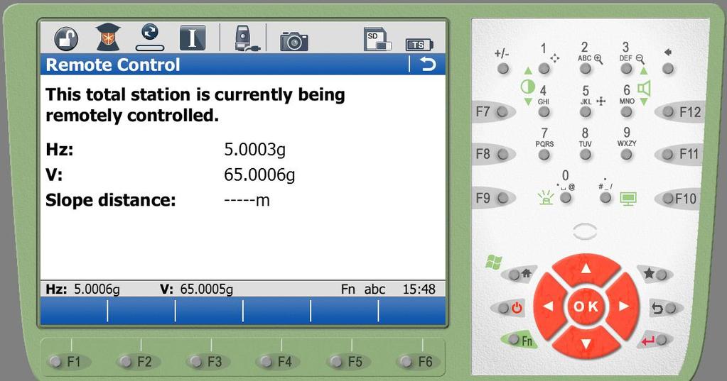
39 5. Robotic Screen 41
40 5. Robotic Screen What is the TS Robotic Screen? The Robotic Screen automatically appears on the TS as soon as the TS is connected to a CS. When the user is in a measurement panel on the CS, the F1 to F3 keys appear additionally on the TS. Trigger measurements from the TS Measurement data, which are measured with the robotic screen, are transferred to the CS. no SD card on the TS needed! 42
41 5. Robotic Screen General Comments Robotic Screen is extremely useful when using a CS controller to control the total station and the user has hooked the controller to the leg of the tripod of the total station because of: maybe to make use of the QWERTY keypad on the CS controller or maybe the user has returned to the total station to make some reflectorless measurements In the robotic case, the TS is just a sensor. The controlling of the TS, applications, data management and licensing are under the control of the CS. Terminal mode: With System1200 instruments there was a so-called Terminal Mode available. This basically meant it was possible to steer a TPS1200 total station from an RX controller and the data would be stored to the CF card of the total station. This is no longer possible with the TS total stations and CS controllers. 43
42 Contents 2. Volumes 3. Check & Adjust 4. CS Connection Wizard 5. Robotic Screen 6. Summary


43 6. Summary The TS15 has the most accurate and fastest Grid Scanning functionality to scan a true grid on a plane The TS15 has grid scan on surface which allows the scanning of any surface Improve efficiency with polygonal grid scan area definition: Only scan what you need The TS15 fully integrates scanning data into the onboard application Easy and simple CS-TS connection process Robotic screen on TS allows the triggering of measurements 45
44 46
Leica Viva TS11 & TS15 Hardware
 Leica Viva TS11 & TS15 Hardware Contents 1. Introduction 2. Product Variants 3. Side Cover 4. Display and Keyboard 5. Environmental Rating 6. Telescope 8. Operating System & Software 9. Summary 1. Introduction
Viva TPS. TS11/15 Total Stations Connect the CS Controller and TS15 with Bluetooth. October Summary
 Viva TPS October 2010 TS11/15 Total Stations Connect the CS Controller and TS15 with Bluetooth Summary This guide will show how to connect the TS instrument and CS controller for wireless operation by
X PAD Construction 2.5.5
 News X PAD Construction January 2014 X PAD Construction 2.5.5 This document contains a list of all changes, new features, bug fixed introduced in this last version of X PAD Construction. GPS RTCM3.1: RTCM3.1
Increase Field Survey Efficiency by Merging Technologies in NOVA MultiStation. Vincent Lui Leica Geosystems Ltd
 Increase Field Survey Efficiency by Merging Technologies in NOVA MultiStation Vincent Lui Leica Geosystems Ltd Advantages of Laser Scanning Advantages of TPS Measurements Advantages of Imaging Advantages
DCP Pocket for TDRA6000. Gerald Koeck / Commercial Support November 2011
 DCP Pocket for TDRA6000 Gerald Koeck / Commercial Support November 2011 1 DCP Pocket for TDRA6000 Features of the new Getac Pocket PC solution with DCP Pocket: Mobile Metrology software solution DCP Pocket
Evidence Recorder Release Notes
 Evidence Recorder 6.0.0 Release Notes Released on: October 5, 2009 Licensing Changes This release has had one big change and that is a new licensing system that gives us more flexibility to add different
Leica RX1250 & TPS 1200 Robot
 Leica RX1250 & TPS 1200 Robot Total Station Extended GeoCOM & Firmware Check For FieldGenius to work correctly with your Total Station, Smart Rover and RX1250, Extended GeoCOM must be enabled. This mode
TcpTunnel. Setting Out and Surveying for Tunnels. Introduction. Project Definition
 TcpTunnel Setting Out and Surveying for Tunnels Introduction This application, installed in a mobile device, provides users with the most common options for setting out tunnels and gathering data from
Leica FlexLine TS09plus Full Precision at High Performance
 Leica FlexLine TS09plus Full Precision at High Performance The First Plus: Original Leica Geosystems Quality For most, quality is relative. Not so at Leica Geosystems. To ensure our instruments meet the
Leica Captivate. Software Release Notes. Field Controllers: CS20, CS35 Total Stations: TS16, TS60, MS60. Release date 5 th March 2018
 Leica Captivate v3.20 Software Release Notes Product Leica Captivate Field Controllers: CS20, CS35 Total Stations: TS16, TS60, MS60 Release date 5 th March 2018 Maintenance date 5 th March 2018 Available
Penmap encore v8.4. Penmap.net v6. Penmap classic / Map500. Penmap encore v7.6
 Penmap classic / Map500 Penmap.net v6 v7.6 v8.4 v9.3 Total Station Leica TPS 300 Leica TPS 400 Leica TPS 800 Leica TPS 700 Leica TPS 1100 * Leica TPS 1200+ * Leica TPS Viva TS11, TS15, TS16* Leica Nova
This document contains a list of all changes, new features, bug fixed introduced in this last version of X PAD Survey.
 News X PAD Survey - January 2014 X PAD Survey 2.5.5 This document contains a list of all changes, new features, bug fixed introduced in this last version of X PAD Survey. GPS X-Y RSM: X and Y RMS accuracy
Leica Viva TPS October 2010
 Leica Viva TPS TS11/15 CS10/15 Summary Firmware is software that is embedded in a piece of hardware. More or less it is software for hardware. Leica regularly releases updated firmware to improve performance
Quick Start Guide. Leica TPS TC1800 (Direct) Leica - Communication Settings (19200,8,None,1)
 Leica - Communication Settings (19200,8,None,1)") Quick Start Guide Leica TPS TC1800 (Direct) Leica - Communication Settings (19200,8,None,1) 1. Turn on the instrument 2. Level the instrument 3. Select F3 - Soft Key CONF 4. Select menu item 3 - GSI communication
Quick Start Guide Leica TPS TC1800 (Direct) Leica - Communication Settings (19200,8,None,1) 1. Turn on the instrument 2. Level the instrument 3. Select F3 - Soft Key CONF 4. Select menu item 3 - GSI communication
Presentation Overview
 Stringless Concrete Paving STRINGLESS CONCRETE PAVING ACPA BUS TOUR AUGUST 5, 2015 Presentation Overview 1) Manufactures 2) Components needed for Stringless Paving 3) Conventional Methods VS Stringless
Leica FlexLine plus. Product Presentation V4.00
 Leica FlexLine plus Product Presentation V4.00 Leica FlexLine plus Table of contents 1. FlexLine plus - Product Concept 2. FlexLine plus - Hardware Features 3. FlexField plus - Onboard Firmware 4. FlexLine
Leica FlexLine TS06plus Top Precision meets High Efficiency
 Leica FlexLine TS06plus Top Precision meets High Efficiency The First Plus: Original Leica Geosystems Quality For most, quality is relative. Not so at Leica Geosystems. To ensure our instruments meet the
Defining your Scan/Point Cloud Density: Page 3. Important Notes! about framing, the Camera & Density: Page 4
 Trimble Survey Controller: Scanning with the Trimble VX Scan Station California Surveying & Drafting Supply Technical Support Services Contents: Starting a Scan: Page 2 Polygonal Framing: Page 2 Rectangular
DCP Pocket for Leica TDRA6000 Mobile and ruggedized large-volume metrology package
 www.leica-geosystems.com/metrology DCP Pocket for Leica TDRA6000 Mobile and ruggedized large-volume metrology package DCP Pocket for Leica TDRA6000 - Feature based measurements - Scanning - Angle and distance
Leica FlexLine TS06plus Top precision meets high efficiency
 Leica FlexLine TS06plus Top precision meets high efficiency The First Plus: Original Leica Geosystems quality For most, quality is relative. Not so at Leica Geosystems. To ensure our instruments meet the
How To Combined TPS and GPS adjustment
 How To Combined TPS and GPS adjustment Version 4.4 Sweco Nederland B.V. All rights reserved Contents 1. Introduction 3 2. New MOVE3 Project 3 3. Options 4 4. Default standard deviations 6 5. Import GNSS/GPS
FieldGenius 2005 Ver 1.2 MicroSurvey Software, Inc. 2005
 New Functionality GPS Measurements Two new options in Program Settings that will speed up the measurement process when using an RTK receiver. Auto GPS Stats If this is turned on, during a measurement if
TDS Nomad Connect To Bluetooth Instrument. Tested with Trimble Nomad with integrated Bluetooth, and Sokkia 530R3 total station.
 TDS Nomad Connect To Bluetooth Instrument Tested with Trimble Nomad with integrated Bluetooth, and Sokkia 530R3 total station. Configure a Bluetooth COM Port (FIRST TIME ONLY) Before starting, exit from
Softrock GeoMos Manual For AutoSlope Users
 Softrock GeoMos Manual For AutoSlope Users Software Version 5 Manual Version 1.6 Softrock Solutions specialise in slope monitoring. We have developed software and systems that will assist you with your
Leica Captivate. Software Release Notes. Field Controllers: CS20, CS35 Total Stations: TS16, TS60, MS60, TS13 GNSS Sensors: GS18 T
 Leica Captivate v4.10 Software Release Notes Product Leica Captivate Field Controllers: CS20, CS35 Total Stations: TS16, TS60, MS60, TS13 GNSS Sensors: GS18 T Release date 10 th December 2018 Maintenance
Evidence Recorder Release Notes
 Evidence Recorder 7.1.0 Release Notes Released on: August 20, 2010 Important Notes We will be dropping support for several older builds of Evidence Recorder including: Allegro CE, Toughbook, Recon.Net,
Trimble Survey Controller. Release Notes
 Trimble Survey Controller Release Notes Version 10.5 Revision A September 2002 Corporate Office Trimble Navigation Limited Engineering and Construction Division 5475 Kellenburger Road Dayton, Ohio 45424-1099
Menu Updates The main menus have been revised and updated to provide a more consistent user experience. [F3079, F3085, F3098]
![Menu Updates The main menus have been revised and updated to provide a more consistent user experience. [F3079, F3085, F3098]](/thumbs/72/67082656.jpg "Menu Updates The main menus have been revised and updated to provide a more consistent user experience. [F3079, F3085, F3098]") NEW FEATURES Menu Updates The main menus have been revised and updated to provide a more consistent user experience. [F3079, F3085, F3098] Project Manager The Project Manager was modified to allow quicker
NEW FEATURES Menu Updates The main menus have been revised and updated to provide a more consistent user experience. [F3079, F3085, F3098] Project Manager The Project Manager was modified to allow quicker
TECHNICAL NOTES TRIMBLE SURVEY CONTROLLER SOFTWARE
 TRIMBLE SURVEY CONTROLLER SOFTWARE TECHNICAL NOTES The Trimble Survey Controller software is the data collection solution that will make your survey work faster, easier, and more productive than ever before.
A KHL SPECIAL REPORT SURVEYING
 A KHL SPECIAL REPORT SURVEYING 3 YEARS OF REPORTS FROM CONSTRUCTION EUROPE CONSTRUCTION Rugged and efficient A range of new hardware and software in the surveying sector has been designed to improve efficiency,
Critical Aspects when using Total Stations and Laser Scanners for Geotechnical Monitoring
 Critical Aspects when using Total Stations and Laser Scanners for Geotechnical Monitoring Lienhart, W. Institute of Engineering Geodesy and Measurement Systems, Graz University of Technology, Austria Abstract
TMS Office and TMS Applications Dear TMS users,
 Amberg Technologies AG Trockenloostrasse 21 CH-8105 Regensdorf-Watt Switzerland Phone +41 44 870 92 22 Fax +41 44 870 06 18 info@amberg.ch www.amberg.ch/at Date: July 12 th, 2012 No: 07-2012 From: Product
Leica Captivate. Software Release Notes. Field Controllers: CS20, CS35 Total Stations: TS16, TS60, MS60. Release date 1 st December 2017
 Leica Captivate v3.00 Software Release Notes Product Leica Captivate Field Controllers: CS20, CS35 Total Stations: TS16, TS60, MS60 Release date 1 st December 2017 Maintenance date 1 st December 2017 Available
SmartWorx Viva How to Record Static Observation Data On-Board GS Receivers Operating in Base Mode
 SmartWorx Viva How to Record Static Observation Data On-Board GS Receivers Operating in Base Mode Firmware Version 4.03 AUG12 The Viva system provides many options that improve on needed hardware in the
Provided by Xpert Survey Equipment Click Leica TS06 for Product Info and Updated Pricing. Leica FlexLine TS06plus Top precision meets high efficiency
 Provided by Xpert Survey Equipment Click Leica TS06 for Product Info and Updated Pricing Leica TS06plus Top precision meets high efficiency The First Plus: Leica Geosystems quality For most, quality is
Leica Nova MS60 White paper
 Leica Nova MS60 White paper August 2017 Hannes Maar, Hans-Martin Zogg Leica Geosystems AG Heerbrugg, Switzerland leica-geosystems.com Leica Nova MS60 The new experience in measuring technology site which
Geometric Accuracy Investigations of the Latest Terrestrial Laser Scanning Systems
 Thomas Kersten, Klaus Mechelke, Maren Lindstaedt, Harald Sternberg Geometric Accuracy Investigations of the Latest Terrestrial Laser Scanning Systems Outline of presentation Introduction Laser scanning
HOW TO OPTIMISE THE RECORDING OF GEOMETRICAL DATA AND IMAGE DATA FOR THE PURPOSE OF ARCHITECTURAL SURVEYING
 HOW TO OPTIMISE THE RECORDING OF GEOMETRICAL DATA AND IMAGE DATA FOR THE PURPOSE OF ARCHITECTURAL SURVEYING Michael Scherer Ruhr-University Bochum, Geodesy in Civil Engineering, 44780 Bochum, Germany -
NEW FEATURES. FieldGenius Release Notes May 10, 2017
 NEW FEATURES Alphanumeric Point IDs Improvements made to how alphanumeric Point IDs are handled [F3038, F3080]. Includes: o Sorting points within lists and tables by Point ID now makes use of a natural
FieldGenius 2010 Release Notes
 FieldGenius 2010 Release Notes This document contains the release notes for all FieldGenius 2010 releases. The latest release notes can be found at the end of the document. FieldGenius 2010 4.2.0 (Released
A New Epic to a Legacy of Breakthrough Technology
 SOKKIA CLASSIC A New Epic to a Legacy of Breakthrough Technology Far from home, in the most demanding worksites, you need to rely on toughness and accuracy to pull you through. In the middle of the desert,
Our Challenge : To manage an increasingly complex world!
 SmartPhones Our Challenge : To manage an increasingly complex world! The Leica Response: To enable the capture, and virtualisation of this complex world quickly, easily and accurately New hardware and
Leica Builder... Built to Build
 Leica Builder... Built to Build Leica Builder... Built to Build Instead of tediously setting up strings, with the Builder T100 my masons can start work right away. The Builder T100 or T200 can determine
Release 4.1. Description
 Leica MobileMatriX Release 4.1 Products - Options Packages - Hardware Description Leica MobileMatriX 4.1 Leica Geosystems, 2004-2010 1 PRODUCTS Three different Editions are available: Standard Edition
Adam Hammet & Anthony McClaren. Getting to know the Trimble SX10 Scanning Total Station - Inside and Out ISV Regional Conference 2017: Moama, NSW
 Adam Hammet & Anthony McClaren Getting to know the Trimble SX10 Scanning Total Station - Inside and Out ISV Regional Conference 2017: Moama, NSW Contents Difference between scanner and a Total station
Roll angle in 6DOF tracking. CMSC Charlotte-Concord, July 2008
 Roll angle in 6DOF tracking CMSC Charlotte-Concord, July 2008 Author: Stephen Kyle Senior honorary research fellow, University College London Honorary research fellow, Coventry University Presenter: Steven
GeoMax TPS family. Works when you do.
 Works when you do GeoMax TPS family GeoMax has a complete TPS portfolio to fulfill the needs of all users. Ensure ultimate reliability with GeoMax TPS systems even in challenging environments. Providing
Leica Captivate. Software Release Notes. Field Controllers: CS20, CS35 Total Stations: TS16, TS60, MS60. Release date 7 th June 2016
 Leica Captivate v2.00 Software Release Notes Product Leica Captivate Field Controllers: CS20, CS35 Total Stations: TS16, TS60, MS60 Release date 7 th June 2016 Maintenance date 1 st June 2016 Available
History. The Lingo. I am confused by the different models, what are the differences?
 GeoMax Robot Notes Rev: 2019.03.04 A Robotic Total Station (RTS) is one of the most important and most expensive equipment purchases that a surveyor will make. These notes are updated to include commonly
LEICA TCRA1103 INSTRUMENT SETTINGS
 Survey Management System LEICA TCRA1103 INSTRUMENT SETTINGS Revision: draft D Document Owner OLIVER GLOCKNER CONTRACT MINE SURVEYOR Date Originated 11-July-03 Approval Date Deployment Date Archive Date
Leica Onboard Slope Monitoring Manual Module 6
 Leica Onboard Slope Monitoring Manual Module 6 Manual Version 3.5 Softrock Solutions specialise in slope monitoring. We have developed software and systems that will assist you with your slope monitoring
Version 2.0 English. Leica FlexLine TS02/TS06/TS09 Quick Guide
 Version 2.0 English Leica FlexLine TS02/TS06/TS09 Quick Guide To use the product in a permitted manner, please refer to the detailed safety instructions in the User Manual. Container Contents a b c d e
ND 1202 ND 1203 ND monochrome flat-panel display for position values, dialogs and inputs, graphics functions and soft keys
 ND 1202 ND 1203 ND 1204 Axes* 2 (XY) 3 (XYQ) or 3 (XYZ) 4 (XYZQ) Encoder inputs*» 1 V PP or «TTL (other interfaces upon request) Subdivision factor 10-fold (only for 1 V PP ) Display step 1) Display Functions
TPS1100 Professional Series
 20 30 40 50 TPS1100 Professional Series Application programs Field Manual 2 English Version 2.1 The quick way to start with the TPS1100 Programs. 2 For additional details on single TPS1100 application
Version 7.1 English. Leica GPS1200+ Applications Field Manual
 Version 7.1 English Leica GPS1200+ Applications Field Manual Introduction Purchase Product identification Congratulations on the purchase of a GPS1200+ Series instrument. To use the product in a permitted
LEICA MobileMatriX Equipment List
 LEICA MobileMatriX LEICA MobileMatriX software 742117 GSW450, LEICA MobileMatriX License. Single user license for Standard Edition. ESRI ArcView OEM. Protected. COGO computation and rendering of COGO measurements
Leica TM6100A Industrial Theodolite Product Brochure
 www.leica-geosystems.com/metrology Leica TM6100A Industrial Theodolite Product Brochure Always exceeding the standards Leica Geosystems Leica Geosystems Industrial Theodolites are known around the world
Leica Builder... Built to Build
 Leica Builder... Built to Build Leica Builder... Built to Build Instead of tediously setting up strings, with the Builder T100 my masons can start work right away. The Builder T100 or T200 can determine
Leica Geosystems TPS
 Leica Geosystems TPS Leica Geosystems Total Stations Semiprofessional Basic TS15 TS50 MS50 TM50 TS11 Monitoring ScanStation TS09 plus TS06 plus Professional TS02 plus Flexline Leica FlexLine plus Product
All rights reserved. The rights of DCP05 are owned by A.M.S. Accuracy Management Services Ltd., Oulu, Finland.
 Proprietary information Information in this document is subject to change without notice. Companies, names, and data used in examples herein are fictitious unless otherwise noted. No part of this document
Using terrestrial laser scan to monitor the upstream face of a rockfill weight dam
 Using terrestrial laser scan to monitor the upstream face of a rockfill weight dam NEGRILĂ Aurel Department of Topography and Cadastre Technical University of Civil Engineering Bucharest Lacul Tei Bvd
Reality Capture using: RPAS Technologies & Image Laser Scanners
 Reality Capture using: RPAS Technologies & Image Laser Scanners by Johan Erasmus (RPAS Technologies) & Barend Bornman (Image Laser Scanners) from Aciel Geomatics Laser Scanners High-Definition Surveying
Trimble S6. General. The Trimble S6 Total Station provides the power and flexibility required by today\'s surveying professionals.
 Trimble S6 General Product Description Product Brochure The Trimble S6 Total Station provides the power and flexibility required by today\'s surveying professionals. /upload/165-868-5836.pdf Demonstration
This firmware is protected and can only be loaded onto instruments with valid firmware (software) Maintenance date.
 Maintenance date.") Products TPS1200, GPS1200, RX1250 From System 1200 Product Management Date 17 th July, 2008 DVD ROM Leica SmartWorx DVD (Art. No. 755806) Version SmartWorx v6.00 Download http://downloads.leica-geosystems.com/downloads/index.htm
Products TPS1200, GPS1200, RX1250 From System 1200 Product Management Date 17 th July, 2008 DVD ROM Leica SmartWorx DVD (Art. No. 755806) Version SmartWorx v6.00 Download http://downloads.leica-geosystems.com/downloads/index.htm
Linear, and segmented over up to 1000 points Squareness calibration Matrix compensation over up to 30 x 30 points
 ND 1404 Axes Encoder inputs* 4 (XYZQ)» 1 V PP or «TTL (other interfaces upon request) Subdivision factor* 10-fold (only for 1 V PP ) Display step 1) Display Functions Error compensation Data interface
Version 5.0 English. Leica TPS1200 Applications Field Manual
 Version 5.0 English Leica TPS1200 Applications Field Manual Introduction Purchase Product identification Congratulations on the purchase of a TPS1200 series instrument. To use the product in a permitted
Leica FlexLine Frequently Asked Questions
 Leica FlexLine Frequently Asked Questions Table of Contents What products belong to FlexLine?... 4 Which online commands does FlexLine support?... 4 Can I use TPS400/800 Format Files on the FlexLine Total
Trimble. S6 Total Station. Demonstration Guide
 Trimble S6 Total Station Demonstration Guide Version 1.00 Revision A Part Number 022543-106 January 2005 Contact Information Trimble Geomatics and Engineering Division 5475 Kellenburger Road Dayton, Ohio
icon office release of version
 Product: icon office Date: 17.12.2019 From: Torgny Israelsson icon office release of version 2019.1.11.20 We are pleased to announce the release of icon office 2019. icon office is now available as 64-bit
The Most User-Friendly 3D scanner
 The Most User-Friendly 3D scanner The Solutionix C500 is optimized for scanning small- to medium-sized objects. With dual 5.0MP cameras, the C500 provides excellent data quality at a high resolution. In
Provided by Xpert Survey Equipment Click Topcon GPT-8003A for Product Info and Updated Pricing GPT-8000A/GTS-810A SERIES AUTO TRACKING TOTAL STATION
 Provided by Xpert Survey Equipment Click Topcon GPT-8003A for Product Info and Updated Pricing GPT-8000A/GTS-810A SERIES AUTO TRACKING TOTAL STATION The Solo Survey System that puts you in control The
Trimble Engineering & Construction Group, 5475 Kellenburger Road, Dayton, OH , USA
 Trimble VISION Ken Joyce Martin Koehler Michael Vogel Trimble Engineering and Construction Group Westminster, Colorado, USA April 2012 Trimble Engineering & Construction Group, 5475 Kellenburger Road,
leica industrial theodolite
 product brochure leica industrial theodolite Leica TM6100A Always exceeding the standards Leica Geosystems Leica Geosystems Industrial Theodolites are known around the world for being the most accurate,
Software for Land Development Professionals
 Software for Land Development Professionals SurvNET Carlson SurvNET is SurvCADD's Network Least Squares Reduction (NLSA) program. This module will perform a least squares adjustment and statistical analysis
Operating Instructions TPL 50 HV
 Operating Instructions TPL 50 HV Serial No: Owner: Delivered by: Introduction The laser, TPL 50 HV, featuring a visible laser beam, is a product from the THEIS PROFI LASER family. A beam splitter provides
Leica FlexField plus & Leica FlexOffice A Perfect Match
 Leica FlexField & Leica FlexOffice A Perfect Match FlexField Onboard Software General File Management Data Import Data Export Status icon bar Instrument Protection with PIN Stake Out beep Map Select Programs
12D LEAST SQUARES NETWORK ADJUSTMENT FROM LEICA 1200
 12D LEAST SQUARES NETWORK ADJUSTMENT FROM LEICA 1200 READINGS The following steps show the conversion of a Leica 1200 DBX file to a horizontal and level network adjustment file and the subsequent adjustments
Trimble Total Station Manual R 200 READ ONLINE
 Trimble Total Station Manual R 200 READ ONLINE SPS620 and SPS720 Robotic Total Stations Trimble Heavy - SPS620 and SPS720 Robotic Total Stations Locate a Dealer. Request a Demo. Main Tab Connect your office
FILE - LEICA M822 LEICA MICROSYSTEMS
 15 December, 2017 FILE - LEICA M822 LEICA MICROSYSTEMS Document Filetype: PDF 383.55 KB 0 FILE - LEICA M822 LEICA MICROSYSTEMS The broad range of systems solutions for micro. With approximately 300 office
Mapping Project Report Table of Contents
 LiDAR Estimation of Forest Leaf Structure, Terrain, and Hydrophysiology Airborne Mapping Project Report Principal Investigator: Katherine Windfeldt University of Minnesota-Twin cities 115 Green Hall 1530
Leica s Pinpoint EDM Technology with Modified Signal Processing and Novel Optomechanical Features
 Leica s Pinpoint EDM Technology with Modified Signal Processing and Novel Optomechanical Features Fadi A Bayoud Ph.D. Geomatics Engineering Contents Leica s Total Stations and Telescope ATR PS Leica s
Perpendicular Offsets - point picker is a check-box type button and will now remain in effect until switched off.
 New Functionality Raw File Viewer This now has a View button that allows the user to see the map in a split view. Tapping on certain records will show up as icons in the view. For example tapping an OC
Provided by Xpert Survey Equipment Click Topcon GPT-8205A for Product Info and Updated Pricing GPT-8200A/GTS-820A SERIES AUTO TRACKING TOTAL STATION
 Provided by Xpert Survey Equipment Click Topcon GPT-8205A for Product Info and Updated Pricing GPT-8200A/GTS-820A SERIES AUTO TRACKING TOTAL STATION The Solo Survey System that puts you in control The
2012 Product Catalogue
 It s Professional 2012 Product Catalogue FOIF Canada Inc. 4180 Boul. Thimens Saint-Laurent, QC, H4R 2B9, Canada Tel: +1 (514) 336-0003 Fax: +1 (514) 336-0300 Email: info@foif.ca Web: www.foif.ca 2 2012
Product Leica Geo Office 8.2 Date October 26th, 2011
 Product Leica Geo Office 8.2 Date October 26th, 2011 Leica Geosystems AG Heinrich-Wild-Strasse CH-9435 Heerbrugg Switzerland 1 About this Release LEICA GEO OFFICE VERSION 8.2 LEICA Geo Office (LGO) is
ND 1300 QUADRA-CHEK the Digital Readouts for Convenient 2-D Measurement
 ND 1300 QUADRA-CHEK the Digital Readouts for Convenient 2-D Measurement The ND 1300 QUADRA-CHEK digital readouts can support up to four axes. They function as measuring computers with 2-D acquisition of
How to Measure Wedge. Purpose. Introduction. Tools Needed
 Purpose Optical Wedge Application (OWA) is an add-on analysis tool for measurement of optical wedges in either transmission or reflection. OWA can measure a single part or many parts simultaneously (e.g.
T-SCAN 3 3D DIGITIZING
 T-SCAN 3 3D DIGITIZING 2 T-SCAN 3: THE HANDHELD LASER SCANNER Launching the innovative concept of an intuitive-to-use high-precision laser scanner a few years ago, Steinbichler Optotechnik, as the first
Sokkia Layout v2.0 (12/15/2009) Part Number Rev. A ECO#3767. Copyright 2009 Topcon Positioning Systems, Inc. All Rights Reserved
 Part Number Rev. A ECO#3767. Copyright 2009 Topcon Positioning Systems, Inc. All Rights Reserved") Sokkia Layout v2.0 (12/15/2009) Part Number 7010-0970 Rev. A ECO#3767 Copyright 2009 Topcon Positioning Systems, Inc. All Rights Reserved Table of Contents TABLE OF CONTENTS Table of Contents 3 Getting
Sokkia Layout v2.0 (12/15/2009) Part Number 7010-0970 Rev. A ECO#3767 Copyright 2009 Topcon Positioning Systems, Inc. All Rights Reserved Table of Contents TABLE OF CONTENTS Table of Contents 3 Getting
Product Leica Infinity. Date July 13 t, From Kevin Hanson
 Product Leica Infinity Date July 13 t, 2018 From Kevin Hanson Leica Geosystems AG Heinrich-Wild-Strasse CH-9435 Heerbrugg Switzerland www.leica-geosystems.com Table of Contents 1 About Infinity v3.0.1...
TPS1100 Professional Series
 20 30 40 50 TPS1100 Professional Series Application programs Field Manual 2 English Version 1.0 The quick way to start with the TPS1100 Programs. 2 For additional details on single TPS1100 application
 MS Series MS05A / MS1A Ultra-high Precision Auto-tracking Total Station n 0.5 / 1 Angular Accuracy n High-Performance, versatile EDM n 0.5 mm Distance Accuracy n Optimised Auto-Pointing n Laser Option
Gregory Walsh, Ph.D. San Ramon, CA January 25, 2011
 Leica ScanStation:: Calibration and QA Gregory Walsh, Ph.D. San Ramon, CA January 25, 2011 1. Summary Leica Geosystems, in creating the Leica Scanstation family of products, has designed and conducted
Leica TDRA6000 Product Brochure
 Leica TDRA6000 Product Brochure Version 01/2009 www.leica-geosystems.com/metrology The Laser Station Leica TDRA6000 The Leica TDRA6000 Laser Station is a portable inspection system designed for precision
Leica TPS800 Series Powerful, efficient, reliable and intuitive. PinPoint Technology
 Leica TPS800 Series Powerful, efficient, reliable and intuitive PinPoint Technology powerful Leica TPS800 Performance Series... Three classes of accuracy TPS800 total stations are available in angular
Advanced Vision Guided Robotics. David Bruce Engineering Manager FANUC America Corporation
 Advanced Vision Guided Robotics David Bruce Engineering Manager FANUC America Corporation Traditional Vision vs. Vision based Robot Guidance Traditional Machine Vision Determine if a product passes or
Trimble Survey Controller. Release Notes
 Trimble Survey Controller Release Notes Version 7.70 Revision A January 2001 Corporate Office Trimble Navigation Limited Technical Publications Group 645 North Mary Avenue Post Office Box 3642 Sunnyvale,
Leica TS11 Quick Guide. Version 2.0 English
 Leica TS11 Quick Guide Version 2.0 English TS11, Important Information about your Instrument 1 Important Information about your Instrument 2 Read and follow the User Manual on the accompanying DVD before
technical notes Trimble survey controller field software
 Trimble survey controller field software technical notes For more than a decade, Trimble Survey Controller field software has provided land surveyors with a complete GNSS and optical data-collection solution
Standard Operating Procedure of Triboindenter (Hysitron TI 950)
") Standard Operating Procedure of Triboindenter (Hysitron TI 950) I Sample Loading and Preparation DO NOT TOUCH the bottom of transducer and optical microscope. Always place the tall samples on the most
Standard Operating Procedure of Triboindenter (Hysitron TI 950) I Sample Loading and Preparation DO NOT TOUCH the bottom of transducer and optical microscope. Always place the tall samples on the most