Adam Hammet & Anthony McClaren. Getting to know the Trimble SX10 Scanning Total Station - Inside and Out ISV Regional Conference 2017: Moama, NSW
|
|
|
- Justin Harper
- 5 years ago
- Views:
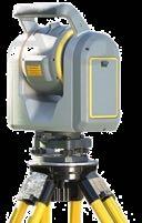
Transcription

1 Adam Hammet & Anthony McClaren Getting to know the Trimble SX10 Scanning Total Station - Inside and Out ISV Regional Conference 2017: Moama, NSW
2 Contents Difference between scanner and a Total station Band scanning and deflection inside telescope Lightning 3DM New tracker system Enhances Trimble Vision Imageing
3 What is the difference between a Total station and a Scanner?

4 Total station ACCURACY!!! Arc second angle accuracy mm distance accuracy Stability and repeatability Multiple uses Prism measurements Automatic tracking DR-measurements Camera guided aiming Robotic operation

5 3D Laser Scanner SPEED!!! Fast EDM Fast beam movement One job! Scan...

6 How do you make a Total Station Scan? MagDrives are fast... But not that fast. Hard to maintain stability with large mass rotating at full speed Dangerous!!! Highest practical speed 1 rotation/s 1 mrad grid would give EDM speed of 6,300 pts/s 1h 45min to complete full dome scan Not practical! Too slow!

7 Meet the Trimble SX10 Scanning Total Station

8 Advanced Total Station Functionality Features Interactive data view Design Points Line Work Topo points Scan data Surfaces
9 Advanced Total Station Functionality Benefit Total station everyday no new workflow All info on screen Ease of use Validate Design ROI

10 Advanced Total Station Functionality Benefit QA for setout through images and reporting QA for pick up via visual Inspection
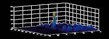
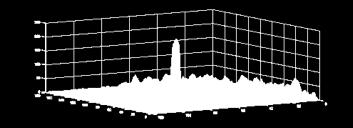
11 Deflection inside telescope & Band Scanning

12 Beam deflection inside telescope
13 Creating a grid


14 Band Scanning

15 How to deflect the beam inside the telescope? Rotating polygon prism! The prism will translate the beam sideways The positive lens converts the translation into an angular deflection Converts continuous movement of prism to saw-tooth deflection pattern
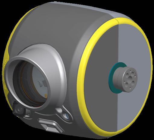
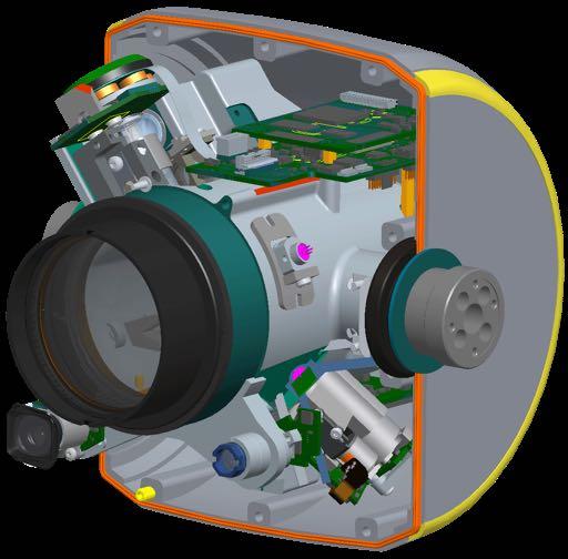

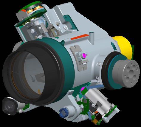

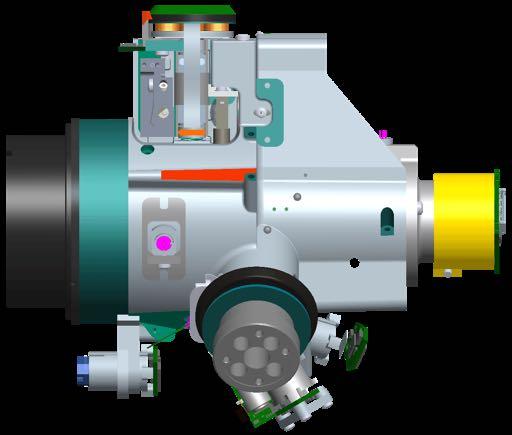
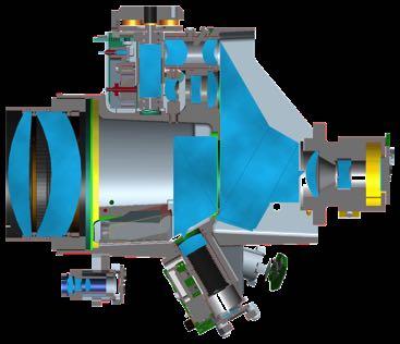

16 Optical implementation in telescope Front lens - EDM - Tracker - Tele-camera Overview camera Primary camera

17 Polygon prism Deflection in action One scan band is about 1 degree wide. 1.7 m wide at 100 m range


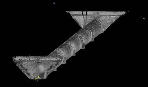
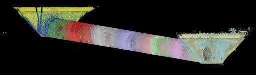
18 Swan Street Bridge Duplication

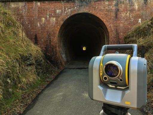
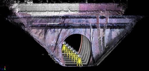
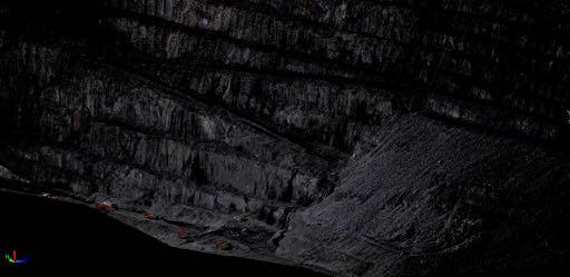
19 Cheviot Tunnel Deformation
20 Lightning 3DM The worlds fastest Total station EDM


21 Lightning 3DM Same Time of Flight principle as used in our proven DRplus Single shot measurement Every laser pulse must give a distance Merging DRplus technologies from S-series with Lightning technology from Trimble TX8.

22 Single shot measurement Powerful laser source with very good beam quality and pulse shape repeatability Direct sampling receiver to allow for single shot measurements Advanced signal processing to achieve total station accuracy


23 Fibre Laser Source Fantastic beam properties: Smallest measurement spot in the industry Round symmetric spot 8 50 m m Great for both scanning and DR measurements Beam Diameter (mm)


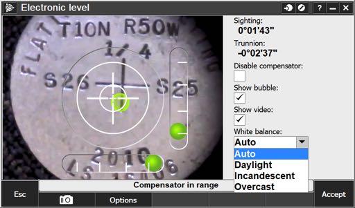
24 Long Range Resection and Scan
25 Brand new Tracker system

26 Why a new tracker system? Why not inherit the S-series tracker? Impossible to combine with the optical setup needed for the beam deflection Camera based tracker systems: Camera sensors have improved greatly in recent years Computation power needed for good performance is now avaliable. Time of a switch of technology!


27 Camera based tracker system The SX10 tracker is camera based - =


28 Which target is your target??? Difficult part is distinguishing your target from everything else. Other targets Other reflective objects Sun reflexes Bright moving objects (car headlights etc.)


29 Moveble tracker transmitter Full front lens must be used for scanning. Tracker transmitter must be moved out of the way while scanning!

30 Enhanced Trimble VISION Imaging

31 Trimble VISION in SX10 Fully integrated and calibrated camera system Instrument operation Documentation Measurement
32 Calibrated plummet camera


33 Bundled Camera System Experiences as one camera with 8 levels 57 to 0.65 Field of view 84 x Zoom at level 6 Level 7 and 8: digital zoom


34 Zoom levels The finest physical zoom is level 6 1 pixel of camera = 1 pixel of screen. Laser spot of distance meter is smaller than the inner cross 1 pixel is m


35 Panorama Images match by calibration not by warping of the content

36 Panorama with overview camera Fixed Exposure at start of Panorama

37 Measure Now Extract Later Benefits Changing client requirements After-thought requests Missed measurements Access the inaccessible REDUCED TRAFFIC MANAGEMENT


38 Measure Now Extract Later Façade documentation Safely measure intersections without the need of Traffic Control
39 Seeing is believing Visit the UPG trade display For a full inside the SX10 Factory tour: xyht.com/lidarimaging/behind-big-eye
40 Special Thanks Outright Surveying: outrightsurveying.com.au Rogerson & Birch Surveyors: rbsurveyors.com.au Think Spatial: thinkspatial.com.au Seymour Whyte: seymourwhyte.com.au Grange Resources: grangeresources.com.au Beveridge Williams & Co.: beveridgewilliams.com.au TGM Group: tgmgroup.com
Trimble Engineering & Construction Group, 5475 Kellenburger Road, Dayton, OH , USA
 Trimble VISION Ken Joyce Martin Koehler Michael Vogel Trimble Engineering and Construction Group Westminster, Colorado, USA April 2012 Trimble Engineering & Construction Group, 5475 Kellenburger Road,
TRIMBLE TOTAL STATIONS: TRUSTED TODAY, DESIGNED FOR TOMORROW.
 GEOSPatial SOLUTIONS Trimble S-SERIES TOTAL Stations TRIMBLE TOTAL STATIONS: TRUSTED TODAY, DESIGNED FOR TOMORROW. For more than a decade, on countless jobs all over the world, Trimble Robotic s have delivered
Trimble Total Stations
 Trimble s The Most Advanced Stations. The Ultimate in Efficiency. Trimble C3 Mechanical Trimble C5 Mechanical Trimble S5 Trimble S7 Trimble S9 Trimble SX10 Trimble s: trusted today, designed for tomorrow.
Trimble Total Stations
 Trimble Total Stations The Most Advanced Stations. The Ultimate in Efficiency. FASTER, EASIER AND MORE PRODUCTIVITY Our seven total stations, C3, C5, S5, S7, S9, S9 HP and the SX10; deliver even greater
Trimble Access and Trimble SX10 Scanning Total Station Guide
 Trimble Optical and Field Software October 2016 Trimble Access and Trimble SX10 Scanning Total Station Guide Trimble SX10 Scanning Total Station Innovative True merging of high-speed scanning, enhanced
2/19/2018. Who are we? Who am I? What is Scanning? How does scanning work? How does scanning work? Scanning for Today s Surveyors
 2/19/2018 Who are we? Scanning for Today s Surveyors Survey, GIS, and Construction dealer Founded in 1988 Employee Owned Headquartered in Bismarck, ND States covered: ND, SD, MN, MT, WY, CO, UT, ID, WA,
Trimble 3D Laser Scanning TRANSFORMING THE WAY THE WORLD WORKS
 Trimble 3D Laser Scanning Speed, Precision and Versatility Complete Solutions for Every Challenge CAPTURE AND DELIVER PRECISE DATA. FASTER. For scanning professionals, speed and precision are critical.
Complete Barrel Measuring and Inspection System. PS Series. User s manual
 Complete Barrel Measuring and Inspection System PS Series User s manual SAFETY PRECAUTIONS... 3 ELECTROMAGNETIC COMPATIBILITY... 3 LASER SAFETY... 3 GENERAL INFORMATION... 3 BASIC DATA AND PERFORMANCE
Geometric Accuracy Investigations of the Latest Terrestrial Laser Scanning Systems
 Thomas Kersten, Klaus Mechelke, Maren Lindstaedt, Harald Sternberg Geometric Accuracy Investigations of the Latest Terrestrial Laser Scanning Systems Outline of presentation Introduction Laser scanning
SPS ZOOM D Laser Scanner SPS ZOOM 300
 3D Laser Scanner 3D Laser Scanner A 3D laser scanner is a device that collects precise spatial data of objects or environments. The collected point cloud data can then be used to construct digital three
Defining your Scan/Point Cloud Density: Page 3. Important Notes! about framing, the Camera & Density: Page 4
 Trimble Survey Controller: Scanning with the Trimble VX Scan Station California Surveying & Drafting Supply Technical Support Services Contents: Starting a Scan: Page 2 Polygonal Framing: Page 2 Rectangular
Optical Sensors: Key Technology for the Autonomous Car
 Optical Sensors: Key Technology for the Autonomous Car Rajeev Thakur, P.E., Product Marketing Manager, Infrared Business Unit, Osram Opto Semiconductors Autonomously driven cars will combine a variety
(and what the numbers mean)
") Using Neutral Density Filters (and what the numbers mean) What are ND filters Neutral grey filters that effectively reduce the amount of light entering the lens. On solid ND filters the light-stopping
Using Neutral Density Filters (and what the numbers mean) What are ND filters Neutral grey filters that effectively reduce the amount of light entering the lens. On solid ND filters the light-stopping
Leica Viva TS11 & TS15 Hardware
 Leica Viva TS11 & TS15 Hardware Contents 1. Introduction 2. Product Variants 3. Side Cover 4. Display and Keyboard 5. Environmental Rating 6. Telescope 8. Operating System & Software 9. Summary 1. Introduction
technical notes Trimble survey controller field software
 Trimble survey controller field software technical notes For more than a decade, Trimble Survey Controller field software has provided land surveyors with a complete GNSS and optical data-collection solution
TECHNICAL NOTES TRIMBLE SURVEY CONTROLLER SOFTWARE
 TRIMBLE SURVEY CONTROLLER SOFTWARE TECHNICAL NOTES The Trimble Survey Controller software is the data collection solution that will make your survey work faster, easier, and more productive than ever before.
Roll angle in 6DOF tracking. CMSC Charlotte-Concord, July 2008
 Roll angle in 6DOF tracking CMSC Charlotte-Concord, July 2008 Author: Stephen Kyle Senior honorary research fellow, University College London Honorary research fellow, Coventry University Presenter: Steven
Trimble. S6 Total Station. Demonstration Guide
 Trimble S6 Total Station Demonstration Guide Version 1.00 Revision A Part Number 022543-106 January 2005 Contact Information Trimble Geomatics and Engineering Division 5475 Kellenburger Road Dayton, Ohio
Gregory Walsh, Ph.D. San Ramon, CA January 25, 2011
 Leica ScanStation:: Calibration and QA Gregory Walsh, Ph.D. San Ramon, CA January 25, 2011 1. Summary Leica Geosystems, in creating the Leica Scanstation family of products, has designed and conducted
White Paper. Inside Trimble TX6 and TX8 Color Acquisition. Prepared by Gregg Jackson and Gregory Lepere. ABSTRACT
 White Paper Inside Trimble TX6 and TX8 Color Acquisition Prepared by Gregg Jackson and Gregory Lepere www.trimble.com/3dscanning ABSTRACT With the release of the new Trimble TX6 and TX8, Trimble introduced
Trimble RealWorks. What s new in version 9.0
 Trimble RealWorks What s new in version 9.0 Trimble RealWorks v9.0 What s new Over 40 new features and enhancements Navigation and visualization improvements SketchUp interoperability Additional 3 rd party
Aerial and Mobile LiDAR Data Fusion
 Creating Value Delivering Solutions Aerial and Mobile LiDAR Data Fusion Dr. Srini Dharmapuri, CP, PMP What You Will Learn About LiDAR Fusion Mobile and Aerial LiDAR Technology Components & Parameters Project
Leica FlexLine TS09plus Full Precision at High Performance
 Leica FlexLine TS09plus Full Precision at High Performance The First Plus: Original Leica Geosystems Quality For most, quality is relative. Not so at Leica Geosystems. To ensure our instruments meet the
3D Laser Scanner VS1000 User Manual
 3D Laser Scanner VS1000 User Manual 1 VS1000 Introduction SMART MAX GEOSYSTEMS CO., LTD VS1000 3D Laser Scanner based on pulses ranging principle, could quick acquire massive point cloud data from the
Leica s Pinpoint EDM Technology with Modified Signal Processing and Novel Optomechanical Features
 Leica s Pinpoint EDM Technology with Modified Signal Processing and Novel Optomechanical Features Fadi A Bayoud Ph.D. Geomatics Engineering Contents Leica s Total Stations and Telescope ATR PS Leica s
Leica Viva SmartWorx Viva on TS
 Leica Viva SmartWorx Viva on TS Contents 2. Volumes 3. Check & Adjust 4. CS Connection Wizard 5. Robotic Screen 6. Summary 2 Contents 2. Volumes 3. Check & Adjust 4. CS Connection Wizard 5. Robotic Screen
Leica Nova MS60 White paper
 Leica Nova MS60 White paper August 2017 Hannes Maar, Hans-Martin Zogg Leica Geosystems AG Heerbrugg, Switzerland leica-geosystems.com Leica Nova MS60 The new experience in measuring technology site which
3D Laser Scanning Technology. Fast, Safe, Accurate. Rugged hardware and powerful software combined with streamlined survey workflow
 3D Laser Scanning Technology Fast, Safe, Accurate Rugged hardware and powerful software combined with streamlined survey workflow Maptek specialises in the research, development and application of 3D laser
Provided by Xpert Survey Equipment Click Topcon GPT-8003A for Product Info and Updated Pricing GPT-8000A/GTS-810A SERIES AUTO TRACKING TOTAL STATION
 Provided by Xpert Survey Equipment Click Topcon GPT-8003A for Product Info and Updated Pricing GPT-8000A/GTS-810A SERIES AUTO TRACKING TOTAL STATION The Solo Survey System that puts you in control The
Critical Aspects when using Total Stations and Laser Scanners for Geotechnical Monitoring
 Critical Aspects when using Total Stations and Laser Scanners for Geotechnical Monitoring Lienhart, W. Institute of Engineering Geodesy and Measurement Systems, Graz University of Technology, Austria Abstract
Trimble VISION Positions from Pictures
 Trimble VISION Positions from Pictures This session will cover What Is Trimble VISION? Trimble VISION Portfolio What Do you Need? How Does It Work & How Accurate Is It? Applications Resources Trimble VISION
Commercial suas The Right Tool for the Right Job
 Commercial suas The Right Tool for the Right Job Presentation Objectives Overview of current data collection technologies UAS Systems Overview Surveyor 2.0 Project Case Study Mobile LiDAR & suas How Do
Increase Field Survey Efficiency by Merging Technologies in NOVA MultiStation. Vincent Lui Leica Geosystems Ltd
 Increase Field Survey Efficiency by Merging Technologies in NOVA MultiStation Vincent Lui Leica Geosystems Ltd Advantages of Laser Scanning Advantages of TPS Measurements Advantages of Imaging Advantages
GeoMax Total Station Zoom30 Series
 GeoMax Total Station Zoom30 Series GeoMax About Us GeoMax is an internationally active company developing, manufacturing and distributing quality construction and surveying instruments. We provide a comprehensive
Active Stereo Vision. COMP 4900D Winter 2012 Gerhard Roth
 Active Stereo Vision COMP 4900D Winter 2012 Gerhard Roth Why active sensors? Project our own texture using light (usually laser) This simplifies correspondence problem (much easier) Pluses Can handle different
White Paper. Inside Trimble TX6 and TX8 Deep Dive into Lightning Technology. Prepared by Gregg Jackson and Gregory Lepere ABSTRACT
 White Paper Inside Trimble TX6 and TX8 Deep Dive into Lightning Technology Prepared by Gregg Jackson and Gregory Lepere ABSTRACT With the introduction of next generation Trimble Lightning technology, users
AICON MoveInspect XR8
 AICON MoveInspect XR8 PORTABLE. ROBUST. ACCURATE. PRODUCT BROCHURE THE NEW BENCHMARK FOR INSPECTION, TRACKING AND POSITIONING Today, every company has to meet the challenge to develop products within shorter
Trimble Field Solutions in Surveying
 Trimble Field Solutions in Surveying Trimble Survey Controllers and Field Software A total approach to managing fieldwork. RELEASE THE FULL POTENTIAL OF YOUR SURVEYING GEAR AND YOUR BUSINESS Trimble controllers
Trimble S6. General. The Trimble S6 Total Station provides the power and flexibility required by today\'s surveying professionals.
 Trimble S6 General Product Description Product Brochure The Trimble S6 Total Station provides the power and flexibility required by today\'s surveying professionals. /upload/165-868-5836.pdf Demonstration
High-End Surveying Precise, Fast and Intelligent. LEICA TPS1100 Professional Series
 High-End Surveying Precise, Fast and Intelligent LEICA TPS1100 Professional Series TPS1100 Professional Series More time for the essentials. Automated, practical programs are the main features of the TPS1100
Licensed Features - Trimble Business Center v3.10
 Licensed Features - Trimble Business Center v3.10 The following table lists the features available in Trimble Business Center based on the installed. Feature No License Base Complete Advanced Photogrammetry
Overview of the Trimble TX5 Laser Scanner
 Overview of the Trimble TX5 Laser Scanner Trimble TX5 Revolutionary and versatile scanning solution Compact / Lightweight Efficient Economical Ease of Use Small and Compact Smallest and most compact 3D
: Easy 3D Calibration of laser triangulation systems. Fredrik Nilsson Product Manager, SICK, BU Vision
 : Easy 3D Calibration of laser triangulation systems Fredrik Nilsson Product Manager, SICK, BU Vision Using 3D for Machine Vision solutions : 3D imaging is becoming more important and well accepted for
Leica TPS800 Series Powerful, efficient, reliable and intuitive. PinPoint Technology
 Leica TPS800 Series Powerful, efficient, reliable and intuitive PinPoint Technology powerful Leica TPS800 Performance Series... Three classes of accuracy TPS800 total stations are available in angular
Leica TDRA6000 Product Brochure
 Leica TDRA6000 Product Brochure Version 01/2009 www.leica-geosystems.com/metrology The Laser Station Leica TDRA6000 The Leica TDRA6000 Laser Station is a portable inspection system designed for precision
Image Measuring Instrument
 EASY QUICK ACCURATE SAVE Time & Cost Improved efficiency & accuracy L26 All new Image Measuring Instrument Top Series come with new innovative design in structural quality, functionality, and accuracy,
Acuity. Acuity Sensors and Scanners. Product Brochure
 Acuity Acuity Sensors and Scanners Product Brochure CCS PRIMA The CCS Prima series of confocal displacement sensors are amongst the most precise measuring instruments in the world. Using a confocal chromatic
TLS Parameters, Workflows and Field Methods
 TLS Parameters, Workflows and Field Methods Marianne Okal, UNAVCO GSA, September 23 rd, 2016 How a Lidar instrument works (Recap) Transmits laser signals and measures the reflected light to create 3D point
Integrating the Generations, FIG Working Week 2008,Stockholm, Sweden June 2008
 H. Murat Yilmaz, Aksaray University,Turkey Omer Mutluoglu, Selçuk University, Turkey Murat Yakar, Selçuk University,Turkey Cutting and filling volume calculation are important issues in many engineering
ToF Camera for high resolution 3D images with affordable pricing
 ToF Camera for high resolution 3D images with affordable pricing Basler AG Jana Bartels, Product Manager 3D Agenda Coming next I. Basler AG II. 3D Purpose and Time-of-Flight - Working Principle III. Advantages
TLS Parameters, Workflows and Field Methods
 TLS Parameters, Workflows and Field Methods Marianne Okal, UNAVCO GSA, October 20 th, 2017 How a Lidar instrument works (Recap) Transmits laser signals and measures the reflected light to create 3D point
SPD hour All-Round Surveillance PTZ (25X) High Speed Color Dome Camera
 High Speed Color Dome Camera") SPD-2500 24-hour All-Round Surveillance PTZ (25X) High Speed Color Dome Camera www.samsungcctv.com www.webthru.net Broaden your surveillance with the Samsung SPD-2500. See how one speed dome camera can
SPD-2500 24-hour All-Round Surveillance PTZ (25X) High Speed Color Dome Camera www.samsungcctv.com www.webthru.net Broaden your surveillance with the Samsung SPD-2500. See how one speed dome camera can
Ability of Terrestrial Laser Scanner Trimble TX5 in Cracks Monitoring at Different Ambient Conditions
 World Applied Sciences Journal 34 (12): 1748-1753, 2016 ISSN 1818-4952 IDOSI Publications, 2016 DOI: 10.5829/idosi.wasj.2016.1748.1753 Ability of Terrestrial Laser Scanner Trimble TX5 in Cracks Monitoring
Leica FlexLine TS06plus Top Precision meets High Efficiency
 Leica FlexLine TS06plus Top Precision meets High Efficiency The First Plus: Original Leica Geosystems Quality For most, quality is relative. Not so at Leica Geosystems. To ensure our instruments meet the
QUASI-3D SCANNING WITH LASERSCANNERS
 QUASI-3D SCANNING WITH LASERSCANNERS V. Willhoeft, K. Ch. Fuerstenberg, IBEO Automobile Sensor GmbH, vwi@ibeo.de INTRODUCTION: FROM 2D TO 3D Laserscanners are laser-based range-finding devices. They create
THE RANGER-UAV FEATURES
 THE RANGER-UAV The Ranger Series Ranger-UAV is designed for the most demanding mapping applications, no compromises made. With a 9 meter laser range, this system produces photorealistic 3D point clouds
Provided by Xpert Survey Equipment Click Topcon GPT-8205A for Product Info and Updated Pricing GPT-8200A/GTS-820A SERIES AUTO TRACKING TOTAL STATION
 Provided by Xpert Survey Equipment Click Topcon GPT-8205A for Product Info and Updated Pricing GPT-8200A/GTS-820A SERIES AUTO TRACKING TOTAL STATION The Solo Survey System that puts you in control The
Photoneo's brand new PhoXi 3D Camera is the highest resolution and highest accuracy area based 3D
 Company: Photoneo s.r.o. Germany Contact: Veronika Pulisova E-mail: pulisova@photoneo.com PhoXi 3D Camera Author: Tomas Kovacovsky & Jan Zizka Description of the innovation: General description Photoneo's
2/9/2016. Session Agenda: Implementing new Geospatial Technologies for more efficient data capture
 Implementing new Geospatial Technologies for more efficient data capture Jay Haskamp Applied Geospatial Engineer Steve Richter VP Sales Session Agenda: Today s changing technologies and what lies ahead
GeoMax Total Station Zoom30 Series
 GeoMax Total Station Zoom30 Series GeoMax About Us GeoMax is an internationally nology group with strong mar- The close cooperation within active company developing, ket positions within measure- the Hexagon
TECHNICAL NOTES SURVEY PRO WITH TSX
 SURVEY PRO WITH TSX TECHNICAL NOTES Survey Pro software from TDS is the data collection solution of choice for most North American surveyors 1. And with the addition of the Trimble TSX (Trimble Systems
Interactive Collision Detection for Engineering Plants based on Large-Scale Point-Clouds
 1 Interactive Collision Detection for Engineering Plants based on Large-Scale Point-Clouds Takeru Niwa 1 and Hiroshi Masuda 2 1 The University of Electro-Communications, takeru.niwa@uec.ac.jp 2 The University
Laser Eye a new 3D sensor for active vision
 Laser Eye a new 3D sensor for active vision Piotr Jasiobedzki1, Michael Jenkin2, Evangelos Milios2' Brian Down1, John Tsotsos1, Todd Campbell3 1 Dept. of Computer Science, University of Toronto Toronto,
TLS Parameters, Workflows and Field Methods
 TLS Parameters, Workflows and Field Methods Marianne Okal, UNAVCO June 20 th, 2014 How a Lidar instrument works (Recap) Transmits laser signals and measures the reflected light to create 3D point clouds.
Dedicated Software Algorithms for 3D Clouds of Points
 Dedicated Software Algorithms for 3D Clouds of Points Introduction AQSENSE develops and commercializes 3D image acquisition and processing technologies that allow high speed in-line 100% production inspection,
Leica ScanStation C10 The All-in-One Laser Scanner for Any Application
 The All-in-One Laser Scanner for Any Application Versatility, Productivity, Value Many organizations interested in laser scanning to diversify and/or improve current business have been waiting for a scanner
Industrial 2D LASER SCANNER LMS-Q120ii
 LMS-Q120ii Preliminary Datasheet Industrial 2D LASER SCANNER LMS-Q120ii The RIEGL LMS-Q120ii 2D - laser scanner provides accurate noncontact line scanning using a narrow infrared laser beam. The instrument
A colour camera with a colour monitor
 A colour camera with a colour monitor What s the colour of the light you need for a machine-vision application: Colored or white? A black and white camera with a black and white monitor What s the colour
Level 6 Graduate Diploma in Engineering Engineering surveying
 9210-104 Level 6 Graduate Diploma in Engineering Engineering surveying Sample Paper You should have the following for this examination answer booklets non-programmable calculator pens, pencils, drawing
Eamonn Ansbro, Kingsland Observatory, Instrumented UFO research Unique range of information may provide
 Eamonn Ansbro, Kingsland Observatory, Instrumented UFO research Unique range of information may provide Instrumented AOP(UFO) research may discriminate what AOPs UFOs are New information about structure
Leica FlexLine plus. Product Presentation V4.00
 Leica FlexLine plus Product Presentation V4.00 Leica FlexLine plus Table of contents 1. FlexLine plus - Product Concept 2. FlexLine plus - Hardware Features 3. FlexField plus - Onboard Firmware 4. FlexLine
BE INSPIRED.
 BE INSPIRED www.scaninabox.com Last update October 2017 PROFESSIONALISM, OUR CORE Accurately manufactured in every detail, Scan in a Box FX offers high quality 3D Scans. The Made in Italy design has been
MODERN DIMENSIONAL MEASURING TECHNIQUES BASED ON OPTICAL PRINCIPLES
 MODERN DIMENSIONAL MEASURING TECHNIQUES BASED ON OPTICAL PRINCIPLES J. Reichweger 1, J. Enzendorfer 1 and E. Müller 2 1 Steyr Daimler Puch Engineering Center Steyr GmbH Schönauerstrasse 5, A-4400 Steyr,
Techniques for the Application of Radar in Off- Road Robotics
 Techniques for the Application of Radar in Off- Road Robotics M. Sc. Paul Fritsche http://www.rts.uni-hannover.de Page 1 Motivation Why we want to use RADAR in Field Robotics? + - Immune against rain,
Trimble Business Center Software, v3.30
 Trimble Business Center Software, v3.30 We are pleased to announce a new version of the Trimble Business Center software, version 3.30. This new version includes over 30 new features and enhancements increasing
LaCam FAST, ACCURATE, RELIABLE LASER SCANNER FOR HOT SURFACE APPLICATIONS
 LaCam FAST, ACCURATE, RELIABLE LASER SCANNER FOR HOT SURFACE APPLICATIONS 3D Laser Profile Measurement in Hot Vessels and Transport Ladles. - Increases Safety - Reduces Cost - Extends Refractory Life -
1. PRECAUTIONS. Thank you for choosing RUIDE theodolite Disteo 23. Please read this manual carefully before use.
 Thank you for choosing RUIDE theodolite Disteo 23. Please read this manual carefully before use. 1. PRECAUTIONS a. Do not collimate the objective lens directly to the sunlight without a filter. b. Do not
Reality Capture using: RPAS Technologies & Image Laser Scanners
 Reality Capture using: RPAS Technologies & Image Laser Scanners by Johan Erasmus (RPAS Technologies) & Barend Bornman (Image Laser Scanners) from Aciel Geomatics Laser Scanners High-Definition Surveying
RIEGL LMS-Q780. The Versatile, High Altitude Airborne LIDAR Sensor
 RIEGL LMS-Q780 4700m 400kHz The full waveform airborne laser scanner offers great versatility, accuracy, and data quality. The scanner enables you to successfully deliver your projects with industry leading
3D scanning. 3D scanning is a family of technologies created as a means of automatic measurement of geometric properties of objects.
 Acquiring 3D shape 3D scanning 3D scanning is a family of technologies created as a means of automatic measurement of geometric properties of objects. The produced digital model is formed by geometric
two using your LensbAby
 two Using Your Lensbaby 28 Lensbaby Exposure and the Lensbaby When you attach your Lensbaby to your camera for the first time, there are a few settings to review so that you can start taking photos as
Ceilbot vision and mapping system
 Ceilbot vision and mapping system Provide depth and camera data from the robot's environment Keep a map of the environment based on the received data Keep track of the robot's location on the map Recognize
FIRST EXPERIENCES WITH THE TRIMBLE GX SCANNER
 FIRST EXPERIENCES WITH THE TRIMBLE GX SCANNER K. Hanke a, P. Grussenmeyer b, A. Grimm-Pitzinger a, Th. Weinold a a Surveying and Geoinformation Unit, University of Innsbruck Technikerstrasse 13, A 6020
Total Station Series 3000
 Total Station Series 3000 OPTIMIZED FOR PERFORMANCE Advanced Technology Integrated Surveying Maximum Versatility Direct Reflex Capability Optimized for Performance 3600 DR REFLECTORLESS 3300 DR REFLECTORLESS
Alignment Services LLC
 Alignment Services LLC Accuracy and Portability Laser Tracker IIPLUS!TM Laser Tracker II PLUS! surpasses the performance, portability, and accuracy of previous tracker technology. Laser Tracker IIPLUS!
PRESETTER SP40. Pesaro, September 2013
 Pesaro, September 2013 1 PRESETTER SP40 TECHNICAL SPECIFICATIONS: AXIS DIMENSIONS: Diameter 600mm, Height XXXX mm MAIN STRUCTURE: Entirely made in C45 medium carbon steel it ensures greater strength and
Why the Self-Driving Revolution Hinges on one Enabling Technology: LiDAR
 Why the Self-Driving Revolution Hinges on one Enabling Technology: LiDAR Markus Prison Director Business Development Europe Quanergy ID: 23328 Who We Are The leader in LiDAR (laser-based 3D spatial sensor)
BLOCKING CORNERSTONE OF OPTICAL MANUFACTURING. Optical Manufacturing Solutions.
 BLOCKING CORNERSTONE OF OPTICAL MANUFACTURING Optical Manufacturing Solutions. BLOCKING High-precision blocking is not only the start, but also the cornerstone of the entire lens production process. Choosing
Operation Manual. Autocollimator Test Wedge for quick testing of Electronic Autocollimators
 for quick testing of Electronic Autocollimators For Ident.-No.: 223 244 Version date 05.05.2004 1. Basics The is designed for quick testing of accuracy of electronic autocollimators. If a light beam passes
AUTOMATIC MODELLING METHOD FOR STEEL STRUCTURES USING PHOTOGRAMMETRY
 AUTOMATIC MODELLING METHOD FOR STEEL STRUCTURES USING PHOTOGRAMMETRY S. H. Jung a, J. H. Yu a*, J. K. Lee b, L. Ge a a School of Surveying and Spatial Information Systems, University of New South Wales,
Streamline your office to field processes. Peter Madsen
 2017 Streamline your office to field processes Peter Madsen Introduction Improving your office>field>office workflows and processes Data Preparation Data Upload Field Process Coding / Stringing Object
GeoMax TPS family. Works when you do.
 Works when you do GeoMax TPS family GeoMax has a complete TPS portfolio to fulfill the needs of all users. Ensure ultimate reliability with GeoMax TPS systems even in challenging environments. Providing
A Global Laser Brand. Versatile Module
 A Global Laser Brand Versatile Module The Versatile Module The VM (Versatile Module) from Imatronic provides a high quality and cost effect OEM solution to a wide range of applications including Machine
Borescopes. Endoscopy with highest image quality
 Borescopes Endoscopy with highest image quality Rigid endoscopes Unequalled image quality for more than 70 years Borescopes Dr. Karl Storz started to produce ENT instruments in 1945. He wanted to develop
Evidence Recorder Release Notes
 Evidence Recorder 6.0.0 Release Notes Released on: October 5, 2009 Licensing Changes This release has had one big change and that is a new licensing system that gives us more flexibility to add different
FANBEAM. Fanbeam System. Fanbeam is an auto tracking laser system for one or a number of targets. Used with DP, only one target is tracked at a time.
 FANBEAM System is an auto tracking laser system for one or a number of targets. Used with DP, only one target is tracked at a time. The system is made up of 4 parts: Scanning head Control unit Display
A High Speed Face Measurement System
 A High Speed Face Measurement System Kazuhide HASEGAWA, Kazuyuki HATTORI and Yukio SATO Department of Electrical and Computer Engineering, Nagoya Institute of Technology Gokiso, Showa, Nagoya, Japan, 466-8555
LiDAR AT PennDOT Michael Loose, C.P. BOPD Photogrammetry and Surveys
 LiDAR AT PennDOT Michael Loose, C.P. BOPD Photogrammetry and Surveys 2 I. What is LiDAR? II. Benefits of LiDAR III. PennDOT Case Studies IV. Best Practices/Lessons Learned V. Questions 3 4 LiDAR for Engineering
Airborne Laser Survey Systems: Technology and Applications
 Abstract Airborne Laser Survey Systems: Technology and Applications Guangping HE Lambda Tech International, Inc. 2323B Blue Mound RD., Waukesha, WI-53186, USA Email: he@lambdatech.com As mapping products
Optimized Design of 3D Laser Triangulation Systems
 The Scan Principle of 3D Laser Triangulation Triangulation Geometry Example of Setup Z Y X Target as seen from the Camera Sensor Image of Laser Line The Scan Principle of 3D Laser Triangulation Detektion