ArcGIS Desktop: Introduction to Geoprocessing with ModelBuilder Kevin Armstrong ESRI
|
|
|
- Mark Tate
- 5 years ago
- Views:
Transcription


1 ArcGIS Desktop: Introduction to Geoprocessing with ModelBuilder Kevin Armstrong ESRI SERUG

2 What is ModelBuilder? A user-friendly way to automate a series of tools Part of the ArcGIS geoprocessing framework ModelBuilder can run any tool in the ArcToolbox, including scripts, custom tools, and other models Supports GDBs, shapefiles, tables, coverages, rasters, CAD SERUG
3 Geoprocessing and GIS Computing with datata geoprocessing Data compilation, editing, and maintenance Data visualization and exploration SERUG


4 Tools and Framework Tools Performs essential and elemental Operations on GIS data. Learning the tools enables you to Solve real-world problems. Framework The mechanics of using, managing, and Publishing tools. Automating workflows by creating new Tools - models and scripts. SERUG
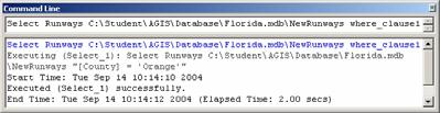
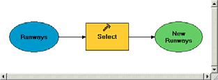
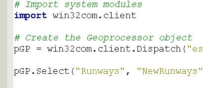
5 Framework: Four ways to use tools Command Line Models Tool dialog Scripts SERUG
6 Demo 1 Create a new toolbox, add new tools/model Build a model Run the model w/in ModelBuilder Add more processes and run them SERUG


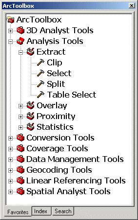
7 Dockable window in any ArcGIS application ArcToolbox Basics System tools organized into toolboxes and toolsets Show/Hide ArcToolbox Window Each toolbox contains tools with similar functionality. Toolsets refine further. Window has four tabs Favorites tree-view of all tools Index and Search - assist in finding tools Results logs what you ve done and helps manage tool results SERUG


8 Demo Review: Model elements Tools Drag and drop into window Use Add button Data Drag and drop into window Drag and drop onto tools Fill in dialog In ArcMap, from the TOC Use Add button SERUG
9 Elements can be: Copied/pasted within the same model, and other models Deleted - remaining elements become not ready to run Renamed - only changes the label not the name Disconnected from a tool (exception: derived data variables) SERUG


10 Demo Review: Model Process and process states SERUG
11 Demo Review: Derived data Project Data data you provide to the model Derived Data data created by tools in the model In/Out Derived Data input data updated by tool Land Cover Table Add Field Land Cover Table (2) SERUG


12 Demo Review: Connecting data and processes There are two ways you can connect data elements to tool elements, either by using the Connect tool or the tool's dialog To connect processes, connect the output of one process to the input of another SERUG
13 Demo Review: Execution messages Status messages can be viewed in: Progress dialog and Command Line window (if opened) Right-click on process and View Messages Reports For each model, it shows: The parameter values specified The time the tool was run The status of the execution The time the tool finished executing Execution errors messages SERUG
14 Demo 2 Run the model from ArcToolbox Create and use parameters Changing model properties SERUG


15 Running a model: From a dialog box Double-click on the model from ArcToolbox If there are no model parameters, just click OK in the dialog If there are model parameters, populate what is required, then click OK to run the model SERUG


16 Demo Review: Model parameters P Model parameters will Have a P next to them Element name becomes Parameter label in dialog box P P SERUG

17 Demo Review: Adding Results Tools > Options > Geoprocessing tab > Add results All OUTPUT parameters will be added to map SERUG


18 Making variables ModelBuilder will create a variable for all input datasets You decide which tool arguments to expose as variables Any variable can be made a model parameter Right-click tool: Make Variable > From Parameter Then set variable as a model parameter SERUG


19 Intermediate data You decide to how to handle intermediate data Data marked as intermediate: Is deleted after model run as a dialog from ArcToolbox Is flagged but NOT deleted automatically if model is run from ModelBuilder window SERUG


20 Model properties dialog Choose Model Properties on the tools context menu, or In the MB window: Model menu > Model Properties SERUG

21 Model properties: General Modify the name, label, description, and style sheet Specify relative vs. absolute paths SERUG


22 Model properties: Parameters Add, remove, or change the order of exposed parameters SERUG
23 Add Feature Set input Demo 3 Prepare model for sharing Some concepts A generic model tool is one where all data is supplied by user just like a system tool. If your model contains references to data (on your local disk or Local Area Network), your tool must have access to the data in order to run. Default values should make sense to the user. SERUG
24 Feature sets and record sets Interactive input of features Example: Allow the user to click a point on the map to buffer rather than using a point feature class as an input Stored in memory Schema taken from existing data or layer Feature type Fields Must have a schema SERUG
25 Sharing tools: How data is used in the tool All variables have values. Can be run w/in ModelBuilder (all processes ready-to to-run). All data accessible. Data conversion tool that expects a certain file format and always writes to same location. Some data variables have values. The data is accessible. Cannot be run within ModelBuilder (some processes not-ready ready-to-run) User enters an address, a five-mile buffer around address created and used to clip known data. Completely generic no data variables have values. Cannot be run within ModelBuilder Like a system tool that takes any dataset. SERUG

26 SERUG


27 Final Model SERUG


28 Start ModelBuilder button on Standard Toolbar in Desktop New at 9.3 Improved Error Messages Results Management Progress Bar SERUG
29 ModelBuilder Support Online ArcGIS Desktop online help Virtual Campus Geoprocessing using ModelBuilder (free) Geoprocessing CAD data with ArcGIS (free) Author & Publishing Geoprocessing Services (free) Learning ArcGIS Desktop (8 modules - $175) Geoprocessing with ArcGIS Desktop (5 modules - $100) Intro to Urban & Regional Planning (6 modules - $125) Instructor-Led Introduction to ArcGIS II (3 days - $1425) Advanced Analysis with ArcGIS (3 days - $1425) Writing Advanced GP Scripts with Python (3 days - $1425 SERUG
ModelBuilder: An Introduction. Kevin Armstrong
 ModelBuilder: An Introduction Kevin Armstrong What is ModelBuilder? A user-friendly way to automate a series of tools Part of the ArcGIS geoprocessing framework - ModelBuilder can run any tool in the ArcToolbox,
The New Enhancements in ModelBuilder in ArcGIS 10
 The New Enhancements in ModelBuilder in ArcGIS 10 Article ID : TT100036 Software : ArcGIS Desktop 10 Platform : Windows XP, Windows Vista, Windows 7 Date : 1 st May, 2011 Introduction ModelBuilder is a
FME / ArcGIS 9 Data Interoperability Extension
 FME / ArcGIS 9 Data Interoperability Extension About us Founded: 1993 Head office: Vancouver, Canada # of Employees: 45 Target markets: GIS & GPS vendors, Telecom and utilities, Oil & gas, Government agencies
Getting to Know ModelBuilder
 Getting to Know ModelBuilder Offered by Shane Bradt through the UNH Cooperative Extension Geospatial Technologies Training Center Developed by Sandy Prisloe and Cary Chadwick at the Geospatial Technology
Answer the following general questions: 1. What happens when you right click on an icon on your desktop? When you left double click on an icon?
 Name: Date: June 27th, 2011 GIS Boot Camps For Educators Practical: Explore ArcGIS 10 Desktop Tools and functionality Day_1 Lecture 1 Sources: o ArcGIS Desktop help o ESRI website o Getting to Know ArcGIS
Proximity Analysis. Proximity Analysis
 Proximity Analysis Proximity Analysis 1 Ever wonder How close is the nearest gas station? What is the distance between your house and the candy store? What is the shortest route to get to Starbucks? Is
ArcGIS Desktop The Road Ahead. Amadea Azerki
 ArcGIS Desktop The Road Ahead Amadea Azerki Agenda An Overview of ArcGIS 10 Desktop Enhancements User Interface Mapping Editing Analysis Sharing Q & A ArcGIS 10 Overview Focuses on Usability and Productivity
You start model builder through the Geoprocessing > ModelBuilder command:
 ESPM5295 ModelBuilder 1 ModelBuilder Automate Processing ModelBuilder is an ArcMap application that you can use to create processing workflows and tools. You can create something like a flowchart on a
LocateXT Version 1.3 Quick Start
 LocateXT Version 1.3 Quick Start NOTE: Portions of this guide show capabilities not available in certain versions of the LocateXT software product System Requirements Operating System, 32-bit or 64-bit
Creating Geoprocessing Services and Web Tools. Darren Baird, PE, Esri
 Creating Geoprocessing Services and Web Tools Darren Baird, PE, Esri Introduction Both ArcMap and ArcGIS Pro are covered Terms Geoprocessing Services and Web Tools are the same - ArcMap publishes geoprocessing
Priming the Pump Stage II
 Priming the Pump Stage II Modeling and mapping concentration with fire response networks By Mike Price, Entrada/San Juan, Inc. The article Priming the Pump Preparing data for concentration modeling with
GIS IN ECOLOGY: ANALYZING VECTOR DATA
 GIS IN ECOLOGY: ANALYZING VECTOR DATA Contents Introduction... 3 Tools and Functionality for Vector Data... 3 Course Data Sources... 4 Instructions for Copying the Course Dataset... 4 Tasks... 4 Getting
LAB 1: Introduction to ArcGIS 8
 LAB 1: Introduction to ArcGIS 8 Outline Introduction Purpose Lab Basics o About the Computers o About the software o Additional information Data ArcGIS Applications o Starting ArcGIS o o o Conclusion To
Create a personal geodatabase
 Create a personal geodatabase To create a personal geodatabase that corresponds to the same release as the ArcGIS for Desktop client you are using, follow these steps: 1. In ArcCatalog, right-click the
Search & Rescue Map Specifications and Production Workflows
 Search & Rescue Map Specifications and Production Workflows About The Search & Rescue map product and production procedures discussed in this document can be utilized to support search, rescue, and relief
ArcMap: Tips and Tricks
 Esri International User Conference San Diego, California Technical Workshops July 23 27, 2012 ArcMap: Tips and Tricks Miriam Schmidts Jorge Ruiz-Valdepena Agenda Navigating ArcMap Repairing data links
Python: Developing Geoprocessing Tools. David Wynne, Jon Bodamer
 Python: Developing Geoprocessing Tools David Wynne, Jon Bodamer Abstract Join us as we step through the process of creating geoprocessing tools using Python. Using script tools and Python toolboxes as
PYTHON: BUILDING GEOPROCESSING TOOLS. David Wynne, Andrew Ortego
 PYTHON: BUILDING GEOPROCESSING TOOLS David Wynne, Andrew Ortego http://esriurl.com/creatingtools http://esriurl.com/creatingtoolspro Today Putting it together Source code Validation Parameters Best Practices
ArcGIS Pro. Terminology Guide
 ArcGIS Pro Terminology Guide Essential Terminology or Functionality That s New to ArcGIS Pro ArcGIS Pro Project Map Scene Ribbon Tab on the ribbon View Active view Pane Gallery Task Quick Access Toolbar
This support note will discuss several methods of creating no spray zones for Sentinel GIS>
 Reason Sentinel Adulticiding support a polygon no spray layer. Adulticiding mobile software warns the driver when they are approaching a no spray zone so they can turn off the sprayer. Because no spray
ArcGIS Pro Terminology Guide
 ArcGIS Pro Terminology Guide Essential Terminology or Functionality That s New to ArcGIS Pro ArcGIS Pro Project Map Scene Ribbon Tab on the ribbon View Active view Pane Gallery Task Quick Access Toolbar
ArcGIS Pro Terminology Guide
 ArcGIS Pro Terminology Guide Sharing Terminology and User Interface Cross-Reference Share content Project package (.ppkx) Map package (.mpkx) Layer package (.lpkx) Share or publish a web layer Share Web
Laboratory Topic 11: Programming in Model Builder Network (Automating Suitability Analysis)
") Laboratory Topic 11: Programming in Model Builder Network (Automating Suitability Analysis) [ LAEP/GEOG c188 ] Model Builder in ArcGIS 10.4.1 Part I: Introduction Part II: Automate Processing in Suitability
Laboratory Topic 11: Programming in Model Builder Network (Automating Suitability Analysis) [ LAEP/GEOG c188 ] Model Builder in ArcGIS 10.4.1 Part I: Introduction Part II: Automate Processing in Suitability
Geographical Information Systems Institute. Center for Geographic Analysis, Harvard University. LAB EXERCISE 1: Basic Mapping in ArcMap
 Harvard University Introduction to ArcMap Geographical Information Systems Institute Center for Geographic Analysis, Harvard University LAB EXERCISE 1: Basic Mapping in ArcMap Individual files (lab instructions,
Basic Tasks in ArcGIS 10.3.x
 Basic Tasks in ArcGIS 10.3.x This guide provides instructions for performing a few basic tasks in ArcGIS 10.3.1, such as adding data to a map document, viewing and changing coordinate system information,
ArcGIS 9. Geoprocessing in ArcGIS Tutorial
 ArcGIS 9 Geoprocessing in ArcGIS Tutorial Copyright 2001 2006 ESRI All rights reserved. Printed in the United States of America. The information contained in this document is the exclusive property of
Model Builder Tutorial (Automating Suitability Analysis)
") Model Builder Tutorial (Automating Suitability Analysis) Model Builder in ArcGIS 10.x Part I: Introduction Part II: Suitability Analysis: A discussion Part III: Launching a Model Window Part IV: A Simple
Model Builder Tutorial (Automating Suitability Analysis) Model Builder in ArcGIS 10.x Part I: Introduction Part II: Suitability Analysis: A discussion Part III: Launching a Model Window Part IV: A Simple
An Introduction to Data Interoperability
 Esri International User Conference San Diego, California 2012 Technical Workshops July 24/25 An Introduction to Data Interoperability Bruce Harold - Esri Dale Lutz Safe Software Background Why Data Interoperability?
Workshop #12 Using ModelBuilder and Customizing the ArcMap Interface
 Workshop #12 Using ModelBuilder and Customizing the ArcMap Interface Toolboxes can be created in ArcToolbox, in folders or within geodatabases. In this tutorial you will place the toolbox in your project
Delineating Watersheds from a Digital Elevation Model (DEM)
") Delineating Watersheds from a Digital Elevation Model (DEM) (Using example from the ESRI virtual campus found at http://training.esri.com/courses/natres/index.cfm?c=153) Download locations for additional
Delineating Watersheds from a Digital Elevation Model (DEM) (Using example from the ESRI virtual campus found at http://training.esri.com/courses/natres/index.cfm?c=153) Download locations for additional
week 7 THE MODEL BUILDER
 week 7 THE MODEL BUILDER topics of the week What is a model Computer simulation models Model Builder in ArcGIS Model Builder s interface Using the Model Builder What is a model? A model is an approximate
Select the Parks within Forest Acres
 Select the Parks within Forest Acres TASKS RESULT 1. Add the county boundary, municipalities and parks (pts.) layers to your map 2. Save your map (.mxd) to your desktop Your map should look something like
Using Python with ArcGIS
 Using Python with ArcGIS Jason Pardy (jpardy@esri.com) Esri UC2013. Technical Workshop. Agenda A whirlwind tour Python Essentials Using Python in ArcGIS Python Tools Accessing Data Map Automation ArcGIS
Urban vs Rural Selection Tool
 Urban vs Rural Selection Tool This tool was developed to aid in determination of whether a project/facility location is considered to be urban or rural per EPA s guidance. The tool allows the identification
Creating 2D Map Caches with
 Creating 2D Map Caches with ArcGIS Server 9.2 Presented by: The multi-threaded, threaded, over-clocked, dual core Diplo Matt Still AND the fast, the furious, the fully cached, Jonathan Fisk ArcGIS Server
BASICS OF SPATIAL MODELER etraining
 Introduction BASICS OF SPATIAL MODELER etraining Describes the Spatial Modeler workspace and functions and shows how to run Spatial Models. Software Data Spatial Modeler N/A Transcript 0:10 Thank you for
Integrating CAD Data with ArcGIS
 Integrating CAD Data with ArcGIS Agenda An Overview of CAD Drawings CAD Data Structure in ArcGIS Visualization Georeferencing Data Conversion ArcGIS for AutoCAD Q & A CAD Drawings - Overview Widely used
Data Interoperability An Introduction
 2013 Esri International User Conference July 8 12, 2013 San Diego, California Technical Workshop Data Interoperability An Introduction Bruce Harold Esri Dale Lutz Safe Software Background Why Data Interoperability?
A Second Look at DEM s
 A Second Look at DEM s Overview Detailed topographic data is available for the U.S. from several sources and in several formats. Perhaps the most readily available and easy to use is the National Elevation
Explore some of the new functionality in ArcMap 10
 Explore some of the new functionality in ArcMap 10 Scenario In this exercise, imagine you are a GIS analyst working for Old Dominion University. Construction will begin shortly on renovation of the new
CVEN 2012 GEOMATICS LAB SPRING 2016 INTRO TO ESRI ARCGIS
 CVEN 2012 GEOMATICS LAB SPRING 2016 INTRO TO ESRI ARCGIS Objectives 1. Download and Add Data into ArcMap 2. Symbolize and Label Features 3. Navigate and Investigate the Map 4. Explore Attributes and Metadata
The ArcMap Interface and Using Basic ArcMap Analysis Tools to Create a Map
 The ArcMap Interface and Using Basic ArcMap Analysis Tools to Create a Map *You will need a computer with ESRI ArcGIS Desktop version 9.3 or higher installed* Data Download 1. Save the zipped folder with
Stacey Maples GIS Specialist and Instruction Coordinator, Yale University Map Department
 WHAT S NEW IN ARC CGIS 10-5 THINGS YOU SHOUL LD KNOW! (OK, THERE S ACTUALLY MORE THAN 5 HERE) Stacey Maples GIS Specialist and Instruction Coordinator, Yale University Map Department stacey.maples@yale.edu
Finding and Using Spatial Data
 Finding and Using Spatial Data Introduction In this lab, you will download two different versions of the National Wetlands Inventory (NWI) dataset for a region of Massachusetts, from a source on the internet.
Working with Attribute Data and Clipping Spatial Data. Determining Land Use and Ownership Patterns associated with Streams.
 GIS LAB 3 Working with Attribute Data and Clipping Spatial Data. Determining Land Use and Ownership Patterns associated with Streams. One of the primary goals of this course is to give you some hands-on
QGIS Tutorials Documentation
 QGIS Tutorials Documentation Release 0.1 Nathaniel Roth November 30, 2016 Contents 1 Installation 3 1.1 Basic Installation............................................. 3 1.2 Advanced Installation..........................................
Data Interoperability Extension Tutorial
 Data Interoperability Extension Tutorial Copyright 1995-2012 Esri All rights reserved. Table of Contents About the Data Interoperability extension tutorial...................... 3 Exercise 1: Using direct-read
Geospatial Day II Introduction to ArcGIS Editor for Open Street Map
 Geospatial Day II Introduction to ArcGIS Editor for Open Street Map Geospatial Operations Support Team (GOST) Katie McWilliams kmcwilliams@worldbankgroup.org GOST@worldbank.org 0 Using OSM for Network
PYTHON: BUILDING GEOPROCESSING TOOLS. David Wynne, Geri Miller
 PYTHON: BUILDING GEOPROCESSING TOOLS David Wynne, Geri Miller Why we build geoprocessing tools Your work becomes part of the geoprocessing framework - Easy to access and run from within ArcGIS - Familiar
GEOG4017 Geographical Information Systems Lab 3 Data Collection and Integration (I)
") DEPARTMENT OF GEOGRAPHY HONG KONG BAPTIST UNIVERSITY Prof. Q. Zhou GEOG4017 Geographical Information Systems Lab 3 Data Collection and Integration (I) Objectives Before we can use GIS for any analysis
DEPARTMENT OF GEOGRAPHY HONG KONG BAPTIST UNIVERSITY Prof. Q. Zhou GEOG4017 Geographical Information Systems Lab 3 Data Collection and Integration (I) Objectives Before we can use GIS for any analysis
Annotation/Labeling Workshop. Tim Rankin Pat Dolan
 Annotation/Labeling Workshop Tim Rankin Pat Dolan Agenda 8:00am - Introductions 8:05am - Goals of the Workshop 8:15am Labeling 8:45am Annotation Part I 9:15am Break 9:25am Annotation Part II 9:50am Questions
Lesson 8 : How to Create a Distance from a Water Layer
 Created By: Lane Carter Advisor: Paul Evangelista Date: July 2011 Software: ArcGIS 10 Lesson 8 : How to Create a Distance from a Water Layer Background This tutorial will cover the basic processes involved
How to Set Workspace Environments for Project Work
 How to Set Workspace Environments for Project Work An ESRI Short Tutorial January 2006 ESRI 380 New York St., Redlands, CA 92373-8100, USA TEL 909-793-2853 FAX 909-793-5953 E-MAIL info@esri.com WEB www.esri.com
ArcGIS Basics Working with Labels and Annotation
 ArcGIS Basics Working with Labels and Annotation Labeling in ArcGIS has changed considerably from the old ArcView 3.X version. In ArcGIS label positions are generated automatically, are not selectable,
Python Raster Analysis. Kevin M. Johnston Nawajish Noman
 Python Raster Analysis Kevin M. Johnston Nawajish Noman Outline Managing rasters and performing analysis with Map Algebra How to access the analysis capability - Demonstration Complex expressions and optimization
ArcGIS Network Analyst and Network Dataset. Jim McKinney ESRI
 ArcGIS Network Analyst and Network Dataset Jim McKinney ESRI ArcGIS Network Analyst Everything in ArcView GIS 3x and more Routing Directions Network Analysis Tight Integration with Geoprocessing Models
In this exercise, you ll create a netcdf raster layer using the variable tmin. You will change the display by selecting a different time step.
 Learning to Work with Temporal Data in ArcGIS Working with a netcdf File in ArcGIS Objective NetCDF (network Common Data Form) is a file format for storing multidimensional scientific data (variables)
Data Interoperability An Introduction
 Data Interoperability An Introduction Bruce Harold Dale Lutz - Esri Inc - Safe Software What is the Data Interoperability Extension? Moving data from app to app ETL in industry jargon If you are not the
Visualization with ArcGlobe. Brady Hoak
 Visualization with ArcGlobe Brady Hoak Contents What is ArcGlobe? 3D Mapping and ArcGlobe Displaying data in ArcGlobe ArcGlobe tools Tips for constructing ArcGlobe documents New at ArcGIS 9.3 ArcGIS integration
Exercise 1: Getting to know ArcGIS
 The Scenario You are working for the California Visitor s Commission. You have been asked to prepare a map of California for several dignitaries from out of the country. Your map will need to include enough
Introduction to ArcGIS Online and Story Maps
 Introduction to ArcGIS Online and Story Maps Presented by the University of Connecticut s Center for Land Use Education and Research (CLEAR) CLEAR 1 Welcome! Instructor Introductions Course logistics Student
Working with Metadata in ArcGIS
 Esri International User Conference San Diego, California Technical Workshops July 26, 2012 Working with Metadata in ArcGIS Aleta Vienneau Metadata in ArcGIS ArcGIS metadata goals Editing metadata Setting
Making the Most of Raster Analysis with Living Atlas Data. Aileen Buckley, PhD, Research Cartographer Esri - Redlands
 Making the Most of Raster Analysis with Living Atlas Data Aileen Buckley, PhD, Research Cartographer Esri - Redlands Spatial Analysis with Online Data Your Desktop Web Device Never scrounge for or download
Building Geoprocessing Tools with Python: Beyond the Basics. Dave Wynne
 Building Geoprocessing Tools with Python: Beyond the Basics Dave Wynne Building Geoprocessing Tools with Python: Getting Started Subhead Here This session will focus on creating polished, well-designed
INTRODUCTION TO GIS WORKSHOP EXERCISE
 111 Mulford Hall, College of Natural Resources, UC Berkeley (510) 643-4539 INTRODUCTION TO GIS WORKSHOP EXERCISE This exercise is a survey of some GIS and spatial analysis tools for ecological and natural
Python: Building Geoprocessing Tools
 FedGIS Conference February 13 14, 2017 Washington, DC Python: Building Geoprocessing Tools Michael Rhoades Frank Orr Why we build geoprocessing tools Your work becomes part of the geoprocessing framework
Building tools with Python
 Esri International User Conference San Diego, California Technical Workshops 7/25/2012 Building tools with Python Dale Honeycutt Session description Building Tools with Python A geoprocessing tool does
3.2 Clipping Data Layers
 Advanced Data Management Clipping Data Layers 3.2.1 3.2 Clipping Data Layers Many times you will want to use a smaller part of a layer (like only the roads in one school district or town, not the whole
Welcome to NR402 GIS Applications in Natural Resources. This course consists of 9 lessons, including Power point presentations, demonstrations,
 Welcome to NR402 GIS Applications in Natural Resources. This course consists of 9 lessons, including Power point presentations, demonstrations, readings, and hands on GIS lab exercises. Following the last
New Media in Landscape Architecture: Advanced GIS
 New Media in Landscape Architecture: Advanced GIS - Projections and Transformations - Version 10.2, English ANHALT UNIVERSITY OF APPLIED SCIENCES Hochschule Anhalt Author: Dr. Matthias Pietsch Tutorial-Version:
ArcGIS Pro: Image Segmentation, Classification, and Machine Learning. Jeff Liedtke and Han Hu
 ArcGIS Pro: Image Segmentation, Classification, and Machine Learning Jeff Liedtke and Han Hu Overview of Image Classification in ArcGIS Pro Overview of the classification workflow Classification tools
Exercise 1: An Overview of ArcMap and ArcCatalog
 Exercise 1: An Overview of ArcMap and ArcCatalog Introduction: ArcGIS is an integrated collection of GIS software products for building a complete GIS. ArcGIS enables users to deploy GIS functionality
hereby recognizes that Timotej Verbovsek has successfully completed the web course 3D Analysis of Surfaces and Features Using ArcGIS 10
 3D Analysis of Surfaces and Features Using ArcGIS 10 Completed on September 5, 2012 3D Visualization Techniques Using ArcGIS 10 Completed on November 19, 2011 Basics of Map Projections (for ArcGIS 10)
for ArcSketch Version 1.1 ArcSketch is a sample extension to ArcGIS. It works with ArcGIS 9.1
 ArcSketch User Guide for ArcSketch Version 1.1 ArcSketch is a sample extension to ArcGIS. It works with ArcGIS 9.1 ArcSketch allows the user to quickly create, or sketch, features in ArcMap using easy-to-use
Tutorial 1: Finding and Displaying Spatial Data Using ArcGIS
 Tutorial 1: Finding and Displaying Spatial Data Using ArcGIS This tutorial will introduce you to the following: Websites where you may browse to find geospatial information Identifying spatial data, usable
Cartographic Techniques and Representations
 Cartographic Techniques and Representations NEARC 2007 ESRI Technical Session ESRI, Boston Overview of Presentation Labeling and Annotation Masking Layout Tips Cartographic Representations Labeling versus
Display Layers in Geosoft 3D View
 Use the New 2D/3D Workflow features in Target for ArcGIS In Target for ArcGIS version 3.5, there are three new interconnected features that make integrating 2D and 3D data in plan and section maps easier.
GIS LAB 8. Raster Data Applications Watershed Delineation
 GIS LAB 8 Raster Data Applications Watershed Delineation This lab will require you to further your familiarity with raster data structures and the Spatial Analyst. The data for this lab are drawn from
What should y you expect in this session? Basic to advanced topics Outline What is map caching? Why should I cache? Caching workflow How to create a c
 Designing, Deploying, and Using Cached Map Services David Crosby & Craig Mesimer What should y you expect in this session? Basic to advanced topics Outline What is map caching? Why should I cache? Caching
Working with Events in ArcGIS 8.2
 Working with Events in ArcGIS 8.2 This tutorial is a companion to the article, Understanding Dynamic Segmentation: Working with Events in ArcGIS in the October December 2002 issue of ArcUser magazine.
Encoded URLs in hyperlinks. TerraGo Publisher for ArcGIS TerraGo Publisher for ArcGIS Server TerraGo Arc2Edge Version 7.3.
 TerraGo Publisher for ArcGIS TerraGo Publisher for ArcGIS Server TerraGo Arc2Edge Version 7.3.1, December 2017 What is TerraGo Publisher for ArcGIS? What is TerraGo Arc2Edge? What s new in this release?
What s s Coming in ArcGIS 10 Desktop
 What s s Coming in ArcGIS 10 Desktop Damian Spangrud ArcGIS Product Manager, ESRI dspangrud@esri.com (or at least turn to silent) ArcGIS 10 A Simple & Pervasive System for Using Maps & Geographic Information
Creating a Smaller Data Set from a Larger Data Set Vector Data
 Creating a Smaller Data Set from a Larger Data Set Vector Data Written by Barbara Parmenter, revised by Carolyn Talmadge January 16, 2015 USING THE SELECTION METHOD QUICK METHOD BY CREATING A LAYER FILE...
PYTHON. Scripting for ArcGIS. writeoutput = Inputfc = ar. .ext.{) OUtpUt fc =.. Paul A. Zandbergen. axcpy random. .arcpy, Describe (' is.
 OUtpUt fc =.. Paul A. Zandbergen. axcpy random. .arcpy, Describe (' is.") ' Esri Press REDLANDS CALIFORNIA 'Ti axcpy random From arcpy import env writeoutput = Inputfc = ar OUtpUt fc = I aitcount = int (arcpy,g arcpy, Describe (' st [f = c ~- ist = [] = clesc,oidfrel ext{) r
' Esri Press REDLANDS CALIFORNIA 'Ti axcpy random From arcpy import env writeoutput = Inputfc = ar OUtpUt fc = I aitcount = int (arcpy,g arcpy, Describe (' st [f = c ~- ist = [] = clesc,oidfrel ext{) r
Using GIS to Site Minimal Excavation Helicopter Landings
 Using GIS to Site Minimal Excavation Helicopter Landings The objective of this analysis is to develop a suitability map for aid in locating helicopter landings in mountainous terrain. The tutorial uses
Data Assembly, Part II. GIS Cyberinfrastructure Module Day 4
 Data Assembly, Part II GIS Cyberinfrastructure Module Day 4 Objectives Continuation of effective troubleshooting Create shapefiles for analysis with buffers, union, and dissolve functions Calculate polygon
Creating Mosaic Datasets and Publishing Image Services using Python
 Creating Mosaic Datasets and Publishing Image Services using Python Jie Zhang, Jamie Drisdelle Session Offering ID: 305 Overview Introduction to mosaic dataset Raster product for sensor imagery Automatic
Introduction to Geographic Information Systems Spring 2016
 Introduction to Geographic Information Systems Spring 2016 Exercise 2 Introduction to ArcGIS 10 Projects This exercise will introduce you to the common set-up functions of the ESRI ArcGIS software package.
Using Geoprocessing Services with ArcGIS Web Mapping APIs
 Esri Developer Summit in Europe November 12 London Using Geoprocessing Services with ArcGIS Web Mapping APIs Simon Liu, Andy Gup Who are your presenters? Simon Liu, Esri U.K. GIS Developer sliu@esriuk.com
Appendix 2: Random Plots Workbook: Unstratified Sample
 Appendix 2: Random Plots Workbook: Unstratified Sample These instructions will help users of all skill levels create a random sample of i-tree Eco plot centers, plot areas, and the associated i-tree Eco-required
ArcMap Tips and Tricks
 2013 Esri International User Conference July 8 12, 2013 San Diego, California Technical Workshop ArcMap Tips and Tricks Jack Horton Jorge Ruiz-Valdepeña Esri UC2013. Technical Workshop. Jorge s Agenda
ARC HYDRO GROUNDWATER TUTORIALS
 ARC HYDRO GROUNDWATER TUTORIALS details to cross sections Arc Hydro Groundwater (AHGW) is a geodatabase design for representing groundwater datasets within ArcGIS. The data model helps to archive, display,
Using Python with ArcGIS
 Using Python with ArcGIS Jason Pardy (jpardy@esri.com) Javier Abadia (javier.abadia@esri.es) Esri UC2013. Technical Workshop. Agenda A whirlwind tour Jason: Python Essentials Using Python in ArcGIS Python
Chapter 3 The project
 Chapter 3 The project Background ArcGIS Pro organizes the user experience with data in a completely different way from ArcMap, through a construct known as a project. What is a project? The project is
Introduction to ArcGIS I
 Introduction 1-1 What is ArcGIS? ArcGIS Clients ArcReader E X T E N S I O N S ArcGIS Desktop ArcView ArcEditor ArcInfo ArcGIS Engine ArcPad Custom Application E X T E N S I O N S Web Browser Components
What's New in ArcGIS 9.2 Service Packs
 What's New in ArcGIS 9.2 Service Packs 18 July 2007 Updated for Service Pack 3 This document describes the main enhancements to 9.2 added by the service packs. It does not cover the bug fixes and quality
1. Use the Add Data button to add each of the datasets you wish to convert to the map document.
 Projecting your data In order for many GIS functions to work properly, your datasets need to be stored in a common projected coordinate system. This guide will assist you with the projection process in
Introduc)on to InVEST ArcGIS Tool
on to InVEST ArcGIS Tool") Introduc)on to InVEST ArcGIS Tool Nasser Olwero GMP, Bangkok April 2-6 2012 Background of tool design Why a tool/arcgis Tool? ArcGIS Geoprocessing Framework 1. Tool dialog 2. Command line 3. Model builder
Introduc)on to InVEST ArcGIS Tool Nasser Olwero GMP, Bangkok April 2-6 2012 Background of tool design Why a tool/arcgis Tool? ArcGIS Geoprocessing Framework 1. Tool dialog 2. Command line 3. Model builder
Setting Up Your Working Environment
 Setting Up Your Working Environment What are the topics? - Setting Up Your Working Environment - What is a feature class? ArcGIS Program Modules ArcScene ArcGIS ArcGlobe ArcCatalog ArcMap ArcToolbox Program
ArcPad An Introduction
 ArcPad An Introduction Chris LeSueur, Marika Vertzonis, Hannah Ferrier ArcPad Sessions at the UC Demo Theatre - Preparing and Deploying Data to ArcPad - Using ArcPad in the Field - Customizing ArcPad without