ArcGIS Network Analyst and Network Dataset. Jim McKinney ESRI
|
|
|
- Arabella Powell
- 5 years ago
- Views:
Transcription
1 ArcGIS Network Analyst and Network Dataset Jim McKinney ESRI
2 ArcGIS Network Analyst Everything in ArcView GIS 3x and more Routing Directions Network Analysis Tight Integration with Geoprocessing Models and Scripting ArcToolbox tools New Network Dataset Core Geodatabase enhancement
3 ArcGIS Network Analyst Network Analyst object model Extensible, support for custom applications Migration path for existing software Workstation Arc/Info Network NetEngine ArcLogistics Route ArcIMS RouteServer Framework for future development New solvers New Network Dataset enhancements
4 ArcMap ArcGIS Network Analyst (Desktop) Interactive toolbar and dialogs ArcCatalog Dialogs and wizards Geoprocessing Modeling and scripting Toolbox Network Dataset Supports Shapefiles, PGDB, SDE, and SDC Network Analyst Solvers Pathfinding and allocation algorithms Extensible via ArcObjects
5 Network Extension (Server and Engine) ArcGIS Server Network Extension Centralized computing solution Internet and Intranet support Enterprise computing environment Scaleable and IT compliant ArcGIS Engine Network Extension Embeddable components Lightweight applications
6 Network Analyst Subsystems ArcToolbox ArcMap ArcCatalog Geoprocessing Network Tools Network Layer and Toolbar Wizard and Property Sheets Network Analyst Network UI Network Dataset Commercial Data PGD SDE Shapefiles SDC Geodatabase Filesystem
7 Routing Network Analyst Solvers Multi-point routing (time windows supported on stops) Driving Directions Expandable inset maps Auto generation capability Closest Facility Fixed and mobile asset routing Emergency response Service Areas Complex polygon generation Allocation across networks OD Cost Matrix Origin and destination calculations, spatial interaction Custom algorithm support
8 Network Dataset New network model Enhanced modeling capabilities advanced attribute model support for complex turns and maneuvers support for multi-modal modal networks Supports transportation modeling Designed to work with Network Analyst Extension
9 Network Dataset Supports Shapefiles Direct use of shapefiles Supports Personal Geodatabase Desktop users Supports Enterprise Geodatabase Large Networks Multi-user user server environments Scalable Supports direct reading of SDC

10 Goal: Model Real World Networks multi-modal modal network support
11 Goal: Model Real World Networks Streets A Subway Light Rail multi-modal modal network support B
12 Typical Pathfinding Parameters Hierarchies Favors higher order (faster) streets Curb approach Approaching a stop from a specific side of the road Default turns Left turns take more time than right turns Penalize movements from lower to higher order road classes Restrictions Based on network attributes Barriers Turn Tables Help to create more accurate paths in network

13 Route Solver Find a route (set of network elements) through a set of network locations (points) that minimizes an impedance (cost) attribute Find best order Traveling Salesperson Network locations Stops Barriers Network locations properties Stop Sequence Time windows Curb approach Directions available Multiple restriction options possible Barriers Turns

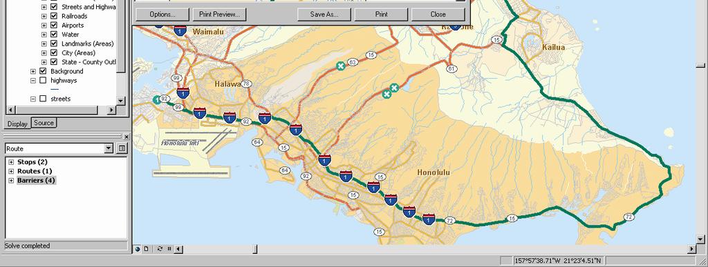
14 Route with Barriers

15 Exact Route vs. Hierarchical Route using major Roads Route using all local streets

16 Closest Facility Solver Given a network location (an incident), find the N closest facilities Examples: Emergency vehicle dispatch Patient to health care provider Customer to stores Input network locations Facilities - usually fixed positions Incidents/events transient positions Barriers Solver Options Number of facilities to find Cutoff distance (e.g. closest ATMs within 3 miles) Hierarchical networks Directions


17 Directions Generates a series of directions Based on route created by Route or Closest Facility solver Expandable inset maps Unit reporting options Print preview options


 Direction of")

18 Given a network dataset Service Areas Create polygons around specified locations Create service area lines Network Locations Facilities Barriers Solver Options Cutoff (20 min Drive time) Breaks (5, 10, 15 and 20 min drive times) Direction of travel From / To facility Polygon generation Separate or Merge Polygon type Disks or rings


19 Service Area Polygons 0.5, 1, 1.5, 2, 2.5 minute service areas for the 41 fire stations in San Francisco
20 Origin Destination Cost Matrix Generate an OD matrix of the cost from each location to all other locations on a network Network Locations Origins Destinations Barriers Solver Options Hierarchical networks Number of destinations Cutoff option For Example: t = time d = distance t,d t,d t,d t,d t,d t,d t,d t,d t,d t,d
21 Geoprocessing Integration with ArcMap toolbar and Network Analyst Window Works with Network Analysis layers in ArcMap and on disk Models and scripts for batch processing or multi-step analysis

22 Network Analyst Toolbox Creating Layers Route Closest Facility Service Area: lines and polygons OD Cost Matrix

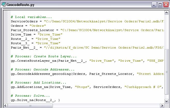
23 Models and Scripts
24 Network Dataset Overview
25 Network Dataset ArcToolbox ArcMap ArcCatalog Geoprocessing Network Tools Network Layer and Toolbar Wizard Property Sheets UI Network Analyst Network Dataset PGD SDE Shapefiles SDC Geodatabase Filesystem
26 Network Dataset New network model Enhanced modeling capabilities turns / maneuvers, multi-modal modal networks advanced attribute (weight) model Borrows concepts from topology dirty areas and incremental build Works with Network Analyst extension
27 Network Dataset Built from simple features no special features like GN Features participation: may also participate in a topology may participate in either a network dataset or geometric network
28 Line features Network Sources define one or more edge elements Point features define junction elements Turn features define turn elements in network explicitly models subset of possible transitions between edge elements during navigation unspecified transitions assigned default turn attribute value
29 Turn Features Turns are features Simple line feature class Model a turn as a sequence of any number of connected lines Turns do not alter connectivity, but traversability e.g., U-turn U turn restriction
30 Turn Features Simple two-part turns N-part turns Restrictions based on vehicle characteristics legal restrictions Default turn penalties part of the network attribute model All U-turns U are restricted All left turns cost 30 seconds
31 Network Elements Three types of elements derived from network sources Edges connect two junctions, bi- directional Junctions connect edges Turns (new)) describe transitions between edges and junctions
32 Connectivity Model Controls how features are connected Simple rules-based approach User defines connectivity model used when the network is built and the connectivity is updated Connectivity is consumed by tools implementing analysis algorithms
33 Connectivity Model Supports definition of multi-modal modal networks ocean freighter, rail, and road network road, highway, subway, and bus network water, sewer, and stormwater network Two typical usage patterns endpoint elevation simplest (ArcView 3.X) midspan / multi-modal modal extending the GN model with connectivity groups
34 Point Feature Connectivity Point classes may span multiple connectivity groups used to create connectivity between lines in different groups Connectivity Group 2 Connectivity Group 1
35 Attributes Control navigation through the network May be used to accumulate information Associated with network elements similar to weights in a geometric network All elements have the same set of attributes Edge elements are directed attributes defined for the edge in either direction
36 Attribute Types Cost accumulated as you traverse a network element (e.g., distance, travel time) Descriptor true for the entire length of the element (e.g., material type) Restriction like a boolean condition (e.g., no travel on one-way roads) Hierarchy three level classification of edge elements; e.g., 1 = highway 2 = major road 3 = surface street
37 Evaluators Return the value of an attribute for a network element Three provided: Constant Field VBScript Custom evaluators can be written by third parties
38 Network Dataset Summary Motivated by transportation industry Contain edges, junctions, and turns Connectivity re-established established at user- controlled times Multi-modal connectivity models Richer attribute model Features may participate in a topology Shapefile support Requires network analyst extension
39 Thank You Questions?
What is Network Analyst?
 What is Network Analyst? Extension for analyzing transportation networks Four network solvers Route Closest Facility Service Area Uses Network Datasets Origin-Destination (OD) Cost Matrix Specialized layers
Networks in GIS. Geometric Network. Network Dataset. Utilities and rivers One-way flow. Traffic data 2-way flow Multi-modal data
 Unit 6: Networks Networks in GIS Model the flow of resources Consist of a set of connected centers or junctions (ArcGIS) displayed as points. Junctions are connected by links, or edges (ArcGIS) displayed
Network Analyst: Performing Network Analysis
 Esri International User Conference San Diego, California Technical Workshops July 24, 2012 Network Analyst: Performing Network Analysis Jay Sandhu Deelesh Mandloi Goals We assume you have some familiarity
The names of other companies and products herein are trademarks or registered trademarks of their respective trademark owners.
 ArcGIS 9 ArcGIS Network Analyst Tutorial G08807_U-AGIS-3DA_tp_94692.ind 1 3/11/04, 10:24 AM Copyright 2005 ESRI. All rights reserved. Printed in the United States of America. The information contained
Deelesh Mandloi, Jay Sandhu, Tarun Chandrasekhar
 ArcGIS 9 ArcGIS Network Analyst Tutorial G08807_U-AGIS-3DA_tp_94692.ind 1 3/11/04, 10:24 AM Copyright 2008 ESRI All rights reserved. Printed in the United States of America. The information contained in
Network Analyst: Creating Network Datasets. Patrick Stevens Alan Hatakeyama
 Network Analyst: Creating Network Datasets Patrick Stevens Alan Hatakeyama Agenda Do you need to create a network dataset? Preparing street data for use in a network dataset Using turns, signposts, and
Answer the following general questions: 1. What happens when you right click on an icon on your desktop? When you left double click on an icon?
 Name: Date: June 27th, 2011 GIS Boot Camps For Educators Practical: Explore ArcGIS 10 Desktop Tools and functionality Day_1 Lecture 1 Sources: o ArcGIS Desktop help o ESRI website o Getting to Know ArcGIS
Network Analyst Creating Network Datasets. Jay Sandhu Frank Kish
 Network Analyst Creating Network Datasets Jay Sandhu Frank Kish Agenda Preparing Street Data for use in a network dataset - One-way streets - Hierarchy - RoadClass attribute Using turns, signposts, and
Network Analyst extension. Oi Origin-Destination i (OD) Cost Matrix
 Cost Matrix") Network Analysis in ArcGIS Engine and ArcGIS Desktop (Deep Dive) Michael Rice Matt Crowder Developer Summit 2007 1 General Information Prerequisites General understanding of Network Analyst Knowledge of
Network Analysis in ArcGIS Engine and ArcGIS Desktop (Deep Dive) Michael Rice Matt Crowder Developer Summit 2007 1 General Information Prerequisites General understanding of Network Analyst Knowledge of
LAB 1: Introduction to ArcGIS 8
 LAB 1: Introduction to ArcGIS 8 Outline Introduction Purpose Lab Basics o About the Computers o About the software o Additional information Data ArcGIS Applications o Starting ArcGIS o o o Conclusion To
Geospatial Day II Introduction to ArcGIS Editor for Open Street Map
 Geospatial Day II Introduction to ArcGIS Editor for Open Street Map Geospatial Operations Support Team (GOST) Katie McWilliams kmcwilliams@worldbankgroup.org GOST@worldbank.org 0 Using OSM for Network
Network Analyst: An Introduction
 2013 Esri International User Conference July 8 12, 2013 San Diego, California Technical Workshop Network Analyst: An Introduction Patrick Stevens Robert Garrity Esri UC2013. Technical Workshop. Introduction
Open File Explorer Start Pro with SanFran project Open Locator in SanFran project Open Browser and AGOL with RouteExample Web map.
 Open File Explorer Start Pro with SanFran project Open Locator in SanFran project Open Browser and AGOL with RouteExample Web map. Open Browser with this: http://nadev.arcgis.com/arcgis/samples/easyvrp/easyvrp.html
Network Analysis with ArcGIS Online and On-premise Services
 2013 Esri International User Conference July 8 12, 2013 San Diego, California Technical Workshop Network Analysis with ArcGIS Online and On-premise Services Deelesh Mandloi Dmitry Kudinov Esri UC2013.
Network Analyst Creating Network Datasets
 2013 Esri International User Conference July 8 12, 2013 San Diego, California Technical Workshop Network Analyst Creating Network Datasets Colin Childs Alan Hatakeyama Esri UC2013. Technical Workshop.
Copyright The McGraw-Hill Companies, Inc. Permission required for reproduction or display.
 Chapter 17. PATH ANALYSIS AND NETWORK APPLICATIONS 17.1 Path Analysis 17.1.1 Source Raster 17.1.2 Cost Raster Box 17.1 Cost Raster for a Site Analysis of Pipelines 17.1.3 Cost Distance Measures 17.1.4
Network Analyst Creating Network Datasets. Colin Childs Alan Hatakeyama
 Network Analyst Creating Network Datasets Colin Childs Alan Hatakeyama Agenda Preparing street data for use in a network dataset - Oneway streets - Hierarchy - RoadClass attribute Using turns, signposts,
Finding Your Way with ArcGIS Network Analyst. Frederic Schettini Michael Rice
 Finding Your Way with ArcGIS Network Analyst Frederic Schettini Michael Rice Agenda Introduction to Network Analyst Working with ArcGIS Engine Working with ArcGIS Server Support & Resources Questions ArcGIS
How to Authorise ArcGIS for Desktop 10.2 Single Use
 Welcome to ArcGIS How to Authorise ArcGIS for Desktop 10.2 Single Use This document will help you authorise your Desktop product and any extensions you have purchased for Single Use. You can perform this
Calculate a Distance Matrix of Locations along River Network
 Calculate a Distance Matrix of Locations along River Network These instructions enable you to measure the length of line segments between points, which is much more useful than simple straight-line distances
Got It Covered. Developing a Standard of Cover. Modeling Standard of Cover with ArcGIS Network Analyst 9.2. By Mike Price, Entrada/San Juan, Inc.
 Got It Covered Modeling Standard of Cover with ArcGIS Network Analyst 9.2 Developing a Standard of Cover Quick response to fires and medical emergencies limits suffering. Emergency service providers strive
What's New in ArcGIS 9.2 Service Packs
 What's New in ArcGIS 9.2 Service Packs 18 July 2007 Updated for Service Pack 3 This document describes the main enhancements to 9.2 added by the service packs. It does not cover the bug fixes and quality
Size: Small Medium X Large
 Field Operations Guide By: Elise Fisher Organization: EF Geographic. L.C. Response Time Analysis Brief Explanation: Uses GIS to assess expected response times from each of their existing public safety
Georeferencing. Georeferencing: = linking a layer or dataset with spatial coordinates. Registration: = lining up layers with each other
 Georeferencing How do we make sure all our data layers line up? Georeferencing: = linking a layer or dataset with spatial coordinates Registration: = lining up layers with each other Rectification: The
Finding and Using Spatial Data
 Finding and Using Spatial Data Introduction In this lab, you will download two different versions of the National Wetlands Inventory (NWI) dataset for a region of Massachusetts, from a source on the internet.
Converting the Roads & Highways Advanced LRS to a Routable Network. Eric J. Rodenberg
 Converting the Roads & Highways Advanced LRS to a Routable Network Eric J. Rodenberg Agenda The ArcGIS Platform Roads and Highways Network Datasets Roads and Highways Events Converting the LRS to a Network
Spatial Analysis (Vector) II
 II") Spatial Analysis (Vector) II GEOG 300, Lecture 9 Dr. Anthony Jjumba 1 A Spatial Network is a set of geographic locations interconnected in a system by a number of routes is a system of linear features
Spatial Analysis (Vector) II GEOG 300, Lecture 9 Dr. Anthony Jjumba 1 A Spatial Network is a set of geographic locations interconnected in a system by a number of routes is a system of linear features
ArcGIS Desktop: Introduction to Geoprocessing with ModelBuilder Kevin Armstrong ESRI
 ArcGIS Desktop: Introduction to Geoprocessing with ModelBuilder Kevin Armstrong ESRI SERUG 2008 1 What is ModelBuilder? A user-friendly way to automate a series of tools Part of the ArcGIS geoprocessing
Integrating ArcGIS to Enterprise Oracle Spatial Using Direct Connect
 Integrating ArcGIS to Enterprise Oracle Spatial Using Direct Connect Michael D. Tsengouras Principal Software Engineer Navigation Technologies Corporation Abstract: Many organizations are adopting Enterprise
hereby recognizes that Timotej Verbovsek has successfully completed the web course 3D Analysis of Surfaces and Features Using ArcGIS 10
 3D Analysis of Surfaces and Features Using ArcGIS 10 Completed on September 5, 2012 3D Visualization Techniques Using ArcGIS 10 Completed on November 19, 2011 Basics of Map Projections (for ArcGIS 10)
A Second Look at DEM s
 A Second Look at DEM s Overview Detailed topographic data is available for the U.S. from several sources and in several formats. Perhaps the most readily available and easy to use is the National Elevation
Create a personal geodatabase
 Create a personal geodatabase To create a personal geodatabase that corresponds to the same release as the ArcGIS for Desktop client you are using, follow these steps: 1. In ArcCatalog, right-click the
FHWA GIS Safe Bike Routes Tools Version 4.0. User Guide
 FHWA GIS Safe Bike Routes Tools Version 4.0 User Guide Prepared for Federal Highway Administration Office of Safety Research and Development 6300 Georgetown Pike, T-203 McLean, VA 22101-2296 By 101 Walnut
ICIT. Brian Hiller ESRI Account Manger. What s new in ArcGIS 10
 ICIT Brian Hiller ESRI Account Manger What s new in ArcGIS 10 ArcGIS 10 Fast Easy Powerful Everywhere late June 2010 ArcGIS System for Geographic Information Desktop Server Mobile Online A System A Complete
Linear Referencing in ArcGIS. GIS by ESRI
 Linear Referencing in ArcGIS GIS by ESRI Copyright 00 ESRI All rights reserved. Printed in the United States of America. The information contained in this document is the exclusive property of ESRI. This
Introduction to ArcSDE 8. John Calkins
 Introduction to ArcSDE 8 John Calkins Why are you here? Introduction to ArcSDE? What is a GeoDatabase? Existing SDE user? Existing ArcInfo user? Technical details on implementation? Just confused... ArcSDE
Annotation/Labeling Workshop. Tim Rankin Pat Dolan
 Annotation/Labeling Workshop Tim Rankin Pat Dolan Agenda 8:00am - Introductions 8:05am - Goals of the Workshop 8:15am Labeling 8:45am Annotation Part I 9:15am Break 9:25am Annotation Part II 9:50am Questions
Search & Rescue Map Specifications and Production Workflows
 Search & Rescue Map Specifications and Production Workflows About The Search & Rescue map product and production procedures discussed in this document can be utilized to support search, rescue, and relief
Esri Best Practices: QA/QC For Your Geodata. Michelle Johnson & Chandan Banerjee
 Esri Best Practices: QA/QC For Your Geodata Michelle Johnson & Chandan Banerjee Overview Understand Document Implement Understanding QA/QC Understanding QA/QC Fit For Use - support your GIS applications?
Streamlining Editing Workflows. Amber Bethell
 Streamlining Editing Workflows Amber Bethell Workflow for solving geographic problems Ask a question Create or acquire data Validate and update data Analyze data Create cartographic product Act upon knowledge
ArcGIS Online: Using the Python API for Transportation Network Analysis. Deelesh Mandloi and Dmitry Kudinov
 ArcGIS Online: Using the Python API for Transportation Network Analysis Deelesh Mandloi and Dmitry Kudinov Metadata Slides and code samples available at http://esriurl.com/ds18napy Documentation at http://developers.arcgis.com/features/directions
Introduction to ArcCatalog
 Introduction to ArcCatalog Introduction To Arc Catalog ArcCatalog is a data- centric GUI tool used for managing spatial data With ArcCatalog you can. Inspect properties and attributes of data Preview and
Utility Network Management in ArcGIS: Migrating Your Data to the Utility Network. John Alsup & John Long
 Utility Network Management in ArcGIS: Migrating Your Data to the Utility Network John Alsup & John Long Presentation Outline Utility Network Preparation - Migration Patterns - Understanding the Asset Package
How to add GTFS data to a network dataset Add GTFS to a Network Dataset version 0.4
 How to add GTFS data to a network dataset Add GTFS to a Network Dataset version 0.4 These instructions explain how to add GTFS public transit data to an ArcGIS network dataset. Melinda Morang, ESRI mmorang@esri.com
MIGRATING AV 3.X TO AV 8.X? Jaishankar J, Md Jafrullah, Arindam Basu
 MIGRATING AV 3.X TO AV 8.X? Jaishankar J, Md Jafrullah, Arindam Basu Abstract ArcGIS suite the latest architectural re-structuring of the gamut of ESRI products under a single umbrella is a unique convergence.
Using the Geodatabase
 Using the Geodatabase February 13, 2002 Presented by: John Stroud, ESRI GeoDatabase Geodatabase comes in two flavors Personal mdb format ArcSDE rdbms format ArcGIS is a suite of three products ArcView,
Editing Versioned Geodatabases : An Introduction
 Esri International User Conference San Diego, California Technical Workshops July 24, 2012 Editing Versioned Geodatabases : An Introduction Cheryl Cleghorn Shawn Thorne Assumptions: Basic knowledge of
The New Enhancements in ModelBuilder in ArcGIS 10
 The New Enhancements in ModelBuilder in ArcGIS 10 Article ID : TT100036 Software : ArcGIS Desktop 10 Platform : Windows XP, Windows Vista, Windows 7 Date : 1 st May, 2011 Introduction ModelBuilder is a
Cartographic Techniques and Representations
 Cartographic Techniques and Representations NEARC 2007 ESRI Technical Session ESRI, Boston Overview of Presentation Labeling and Annotation Masking Layout Tips Cartographic Representations Labeling versus
Geographical Information Systems Institute. Center for Geographic Analysis, Harvard University. LAB EXERCISE 1: Basic Mapping in ArcMap
 Harvard University Introduction to ArcMap Geographical Information Systems Institute Center for Geographic Analysis, Harvard University LAB EXERCISE 1: Basic Mapping in ArcMap Individual files (lab instructions,
Welcome to NR402 GIS Applications in Natural Resources. This course consists of 9 lessons, including Power point presentations, demonstrations,
 Welcome to NR402 GIS Applications in Natural Resources. This course consists of 9 lessons, including Power point presentations, demonstrations, readings, and hands on GIS lab exercises. Following the last
ModelBuilder: An Introduction. Kevin Armstrong
 ModelBuilder: An Introduction Kevin Armstrong What is ModelBuilder? A user-friendly way to automate a series of tools Part of the ArcGIS geoprocessing framework - ModelBuilder can run any tool in the ArcToolbox,
Migrating to ArcGIS 10.2 for Server. Student Edition
 Migrating to ArcGIS 10.2 for Server Student Edition Copyright 2013 Esri All rights reserved. Course version 2.0. Version release date August 2013. Printed in the United States of America. The information
Visualization with ArcGlobe. Brady Hoak
 Visualization with ArcGlobe Brady Hoak Contents What is ArcGlobe? 3D Mapping and ArcGlobe Displaying data in ArcGlobe ArcGlobe tools Tips for constructing ArcGlobe documents New at ArcGIS 9.3 ArcGIS integration
Using OS MasterMap Integrated Transport Network (ITN) Layer with ArcGIS
 Layer with ArcGIS") Using OS MasterMap Integrated Transport Network (ITN) Layer with ArcGIS An ESRI (UK) White Paper Confidentiality Statement This document contains information which is confidential to ESRI (UK) Limited.
Using OS MasterMap Integrated Transport Network (ITN) Layer with ArcGIS An ESRI (UK) White Paper Confidentiality Statement This document contains information which is confidential to ESRI (UK) Limited.
This support note will discuss several methods of creating no spray zones for Sentinel GIS>
 Reason Sentinel Adulticiding support a polygon no spray layer. Adulticiding mobile software warns the driver when they are approaching a no spray zone so they can turn off the sprayer. Because no spray
GIS Applications 22/10/2014. CentrographicStatistics LECTURE 2
 CentrographicStatistics GIS Applications LECTURE 2 The most basic type of descriptors for the spatial distribution of crime incidents are centrographic statistics. -basic parameters - They include: 1.
Using OS MasterMap Integrated Transport Network (ITN) Layer with
 Layer with") Document prepared by ESRI (UK) Ltd Using OS MasterMap Integrated Transport Network (ITN) Layer with ArcGIS An ESRI (UK) White Paper Author: ESRI (UK) Reviewer: Ordnance Survey Released: 17/10/2006 Version:
Document prepared by ESRI (UK) Ltd Using OS MasterMap Integrated Transport Network (ITN) Layer with ArcGIS An ESRI (UK) White Paper Author: ESRI (UK) Reviewer: Ordnance Survey Released: 17/10/2006 Version:
Trimble GPS Analyst extension for ESRI ArcGIS software Customer FAQs
 23 April 2007 Trimble GPS Analyst extension for ESRI ArcGIS software Customer FAQs What is the GPS Analyst extension? Trimble GPS Analyst is an extension to the ESRI ArcGIS software that allows you to
Linear Referencing in ArcGIS : Practical Considerations for the Development of an Enterprisewide GIS
 Linear Referencing in ArcGIS : Practical Considerations for the Development of an Enterprisewide GIS An ESRI Technical Paper April 2003 ESRI 380 New York St., Redlands, CA 92373-8100, USA TEL 909-793-2853
LSGI 521: Principles of GIS. Lecture 5: Spatial Data Management in GIS. Dr. Bo Wu
 Lecture 5: Spatial Data Management in GIS Dr. Bo Wu lsbowu@polyu.edu.hk Department of Land Surveying & Geo-Informatics The Hong Kong Polytechnic University Contents 1. Learning outcomes 2. From files to
Lab Assignment 4 Basics of ArcGIS Server. Due Date: 01/19/2012
 Lab Assignment 4 Basics of ArcGIS Server Due Date: 01/19/2012 Overview This lab assignment is designed to help you develop a good understanding about the basics of ArcGIS Server and how it works. You will
FHWA GIS Safe Routes to School Tools Version 4.0. User Guide
 FHWA GIS Safe Routes to School Tools Version 4.0 User Guide Prepared for Federal Highway Administration Office of Safety Research and Development 6300 Georgetown Pike, T-203 McLean, VA 22101-2296 By 101
Linear Referencing in ArcGIS
 9 ArcGIS Linear Referencing in ArcGIS Copyright 00 004 ESRI All rights reserved. Printed in the United States of America. The information contained in this document is the exclusive property of ESRI. This
Spatial Data Standards for Facilities, Infrastructure, and Environment (SDSFIE)
") Spatial Data Standards for Facilities, Infrastructure, and Environment (SDSFIE) Migration Workflow User Guide Version 1.0 (01 August 2018) Prepared For: US Army Corps of Engineers 2018 Revision History
Spatial Data Standards for Facilities, Infrastructure, and Environment (SDSFIE) Migration Workflow User Guide Version 1.0 (01 August 2018) Prepared For: US Army Corps of Engineers 2018 Revision History
Priming the Pump Stage II
 Priming the Pump Stage II Modeling and mapping concentration with fire response networks By Mike Price, Entrada/San Juan, Inc. The article Priming the Pump Preparing data for concentration modeling with
Urban vs Rural Selection Tool
 Urban vs Rural Selection Tool This tool was developed to aid in determination of whether a project/facility location is considered to be urban or rural per EPA s guidance. The tool allows the identification
Chapter 16: Network Analysis Functions
 Chapter 16: Network Analysis Functions Routing Routing in the API for JavaScript allows you to use the RouteTask to find routes between two or more locations and optionally get driving directions. The
ArcGIS 9. ArcGIS Survey Analyst Tutorial
 ArcGIS 9 ArcGIS Survey Analyst Tutorial Copyright 00 008 ESRI All rights reserved. Printed in the United States of America. The information contained in this document is the exclusive property of ESRI.
Global Delineation with EDNA Data Arc Hydro Version 1.1 Final, July 2005
 Global Delineation with EDNA Data Arc Hydro Version 1.1 Final, July 2005 ESRI 380 New York St., Redlands, CA 92373-8100, USA TEL 909-793-2853 FAX 909-793-5953 E-MAIL info@esri.com WEB www.esri.com Global
Technology Advancements in Pipeline Data Management. Jeff Allen, Pipeline Practice Lead
 Technology Advancements in Pipeline Data Management Jeff Allen, Pipeline Practice Lead Common Patterns for Pipeline Organizations Mapping & Visualization Data Management Field Mobility Monitoring Analytics
ArcGIS 10.1 for Desktop Artie Robinson
 ArcGIS 10.1 for Desktop Artie Robinson ArcGIS A Complete System for Geographic Information Cloud Web Online Mobile Enterprise Desktop Name Change Name Prior to 10.1 ArcGIS Desktop ArcInfo ArcEditor ArcView
Why use an RDBMS? ❽ Data maintenance ❽ Standardized access ❽ Multi-user access ❽ Data protection
 1 Why use an RDBMS? ❽ Data maintenance ❽ Standardized access ❽ Multi-user access ❽ Data protection 2 RDBMSs offer Data protection ❽ Recovery ❽ Concurrency ❽ Security 3 Data protection ❽ Recovery from ❽
Proximity Analysis. Proximity Analysis
 Proximity Analysis Proximity Analysis 1 Ever wonder How close is the nearest gas station? What is the distance between your house and the candy store? What is the shortest route to get to Starbucks? Is
Schematics in ArcMap Tutorial
 Schematics in ArcMap Tutorial Copyright 1995-2010 Esri All rights reserved. Table of Contents Introducing Schematics in ArcMap Tutorial........................ 3 Exercise 1: Getting familiar with Schematics
Using ArcGIS for Water Utility Workflows STUDENT EDITION
 Using ArcGIS for Water Utility Workflows STUDENT EDITION Copyright 2017 Esri All rights reserved. Course version 2.0. Version release date February 2017. Printed in the United States of America. The information
Compilation of GIS data for the Lower Brazos River basin
 Compilation of GIS data for the Lower Brazos River basin Prepared by Francisco Olivera, Ph.D., P.E., Srikanth Koka, and Lauren Walker Department of Civil Engineering October 2, 2006 Contents: Brief Overview
THE HONG KONG POLYTECHNIC UNIVERSITY DEPARTMENT OF LAND SURVEYING & GEO-INFORMATICS LSGI521 PRINCIPLES OF GIS
 THE HONG KONG POLYTECHNIC UNIVERSITY DEPARTMENT OF LAND SURVEYING & GEO-INFORMATICS LSGI521 PRINCIPLES OF GIS Student name: Student ID: Table of Content Working with files, folders, various software and
Configuring, Tuning and Managing ArcGIS Server. Dan O Leary James Cardona Owen Evans
 Configuring, Tuning and Managing ArcGIS Server Dan O Leary James Cardona Owen Evans Introductions and Overview Welcome and Thanks for Attending Approach of this Session Share Best Practices and Techniques
What's New in ArcGIS 9.2 Service Packs
 What's New in ArcGIS 9.2 Service Packs 8 July 2008 Updated for Service Pack 6 This document describes the main enhancements to 9.2 added by the service packs. It does not cover the bug fixes and quality
What s New in Desktop 10.1
 What s New in Desktop 10.1 Damian Spangrud Esri Redlands Trip Down Memory Lane ArcGIS A Complete System for Geographic Information Cloud Web Online Mobile Enterprise Desktop Sharing Information sharing
ArcGIS Mobile - An Introduction. Eric Rodenberg
 ArcGIS Mobile - An Introduction Eric Rodenberg Environmental Systems Research Institute, Inc Copyright 1999 2009 ESRI All rights reserved. Printed in the United States of America. The information contained
GEOG4017 Geographical Information Systems Lab 3 Data Collection and Integration (I)
") DEPARTMENT OF GEOGRAPHY HONG KONG BAPTIST UNIVERSITY Prof. Q. Zhou GEOG4017 Geographical Information Systems Lab 3 Data Collection and Integration (I) Objectives Before we can use GIS for any analysis
DEPARTMENT OF GEOGRAPHY HONG KONG BAPTIST UNIVERSITY Prof. Q. Zhou GEOG4017 Geographical Information Systems Lab 3 Data Collection and Integration (I) Objectives Before we can use GIS for any analysis
Delineating Watersheds from a Digital Elevation Model (DEM)
") Delineating Watersheds from a Digital Elevation Model (DEM) (Using example from the ESRI virtual campus found at http://training.esri.com/courses/natres/index.cfm?c=153) Download locations for additional
Delineating Watersheds from a Digital Elevation Model (DEM) (Using example from the ESRI virtual campus found at http://training.esri.com/courses/natres/index.cfm?c=153) Download locations for additional
NETWORK ANALYST EXTENSION USING ARCGIS 10.X
 NETWORK ANALYST EXTENSION USING ARC 10.X Training Course.com TYC TRAINING OVERVIEW This course will qualify students in Arc Desktop 10.x and, in particular, in ArcMap, ArcCatalog and ArcToolBox, for the
How to Set Workspace Environments for Project Work
 How to Set Workspace Environments for Project Work An ESRI Short Tutorial January 2006 ESRI 380 New York St., Redlands, CA 92373-8100, USA TEL 909-793-2853 FAX 909-793-5953 E-MAIL info@esri.com WEB www.esri.com
ESRI Technology Update. Joe Holubar Larry Young
 ESRI Technology Update Joe Holubar Larry Young Continued Improvement Improving Quality and Extending and Refining Functionality First Half of 2009: Minor Update Release (ArcGIS 9.3.1) ArcGIS Explorer Fall
Explore some of the new functionality in ArcMap 10
 Explore some of the new functionality in ArcMap 10 Scenario In this exercise, imagine you are a GIS analyst working for Old Dominion University. Construction will begin shortly on renovation of the new
Appendix C: GIS Standards and Procedures
 APPENDICES Appendix C: GIS Standards and Procedures Akron Sewer Bureau GIS Standards and Procedures Public Utilities Bureau GIS Standards & Procedures TABLE OF CONTENTS 1. INTRODUCTION 9 2. GENERAL INFORMATION
What s s Coming in ArcGIS 10 Desktop
 What s s Coming in ArcGIS 10 Desktop Damian Spangrud ArcGIS Product Manager, ESRI dspangrud@esri.com (or at least turn to silent) ArcGIS 10 A Simple & Pervasive System for Using Maps & Geographic Information
A Hands-on Experience with Arc/Info 8 Desktop
 Demo of Arc/Info 8 Desktop page 1 of 17 A Hands-on Experience with Arc/Info 8 Desktop Prepared by Xun Shi and Ted Quinby Geography 377 December 2000 In this DEMO, we introduce a brand new edition of ArcInfo,
ArcGIS 9. Geoprocessing in ArcGIS Tutorial
 ArcGIS 9 Geoprocessing in ArcGIS Tutorial Copyright 2001 2006 ESRI All rights reserved. Printed in the United States of America. The information contained in this document is the exclusive property of
ArcGIS 9. Using ArcCatalog
 ArcGIS 9 Using ArcCatalog Copyright 1999, 2003 2004 ESRI All rights reserved. Printed in the United States of America. The information contained in this document is the exclusive property of ESRI. This
Measuring the Lengths of Receiving Polygon Edges
 Measuring the Lengths of Receiving Polygon Edges These instructions enable you to create shapefiles that represent the edge along a receiving polygon that may then be used in the analysis of potential
Exercise 1: Getting to know ArcGIS
 The Scenario You are working for the California Visitor s Commission. You have been asked to prepare a map of California for several dignitaries from out of the country. Your map will need to include enough
ESRI China (Hong Kong) Limited
 Limited") Setting Proper Windows XP Environment for Displaying Spatial Data with Traditional Chinese Article ID : 100007 Software : ArcGIS Desktop 9.x Platform : Windows XP Home, Windows XP Professional Date : September
Setting Proper Windows XP Environment for Displaying Spatial Data with Traditional Chinese Article ID : 100007 Software : ArcGIS Desktop 9.x Platform : Windows XP Home, Windows XP Professional Date : September
1. ArcGIS Desktop 10 (ArcView, ArcEditor, or. 2. Sample dataset from esri.com/arcuser. 3. ArcGIS Maplex extension (optional)
") Changing Lanes Converting DS Map Books to ArcGIS 10 Data Driven Pages By Mike Price, Entrada/San Juan, Inc. What You Will Need 1. ArcGIS Desktop 10 (ArcView, ArcEditor, or ArcInfo license) 2. Sample dataset
Changing Lanes Converting DS Map Books to ArcGIS 10 Data Driven Pages By Mike Price, Entrada/San Juan, Inc. What You Will Need 1. ArcGIS Desktop 10 (ArcView, ArcEditor, or ArcInfo license) 2. Sample dataset
George Mason University Department of Civil, Environmental and Infrastructure Engineering
 George Mason University Department of Civil, Environmental and Infrastructure Engineering Dr. Celso Ferreira Prepared by Lora Baumgartner December 2015 Revised by Brian Ross July 2016 Exercise Topic: GIS
Understanding ArcSDE. GIS by ESRI
 Understanding ArcSDE GIS by ESRI Copyright 1999, 2001 2002 ESRI All rights reserved Printed in the United States of America The information contained in this document is the exclusive property of ESRI
GEOGRAPHIC INFORMATION SYSTEMS Lecture 18: Spatial Modeling
 Spatial Analysis in GIS (cont d) GEOGRAPHIC INFORMATION SYSTEMS Lecture 18: Spatial Modeling - the basic types of analysis that can be accomplished with a GIS are outlined in The Esri Guide to GIS Analysis