Copyright 2012, Oracle and/or its affiliates. All rights reserved.
|
|
|
- Jodie Wilson
- 5 years ago
- Views:
Transcription
1 1


2 Real Life Applications of Location Analytics Dan Geringer, Senior Software Development Manager, Oracle Jayant Sharma, Director Prod Mgmt, Oracle 2
3 The following is intended to outline our general product direction. It is intended for information purposes only, and may not be incorporated into any contract. It is not a commitment to deliver any material, code, or functionality, and should not be relied upon in making purchasing decisions. The development, release, and timing of any features or functionality described for Oracle s products remains at the sole discretion of Oracle. 3
4 Program Agenda Introducing Oracle Spatial and Graph Some Use Cases Discussion 4
5 INTRODUCING 5
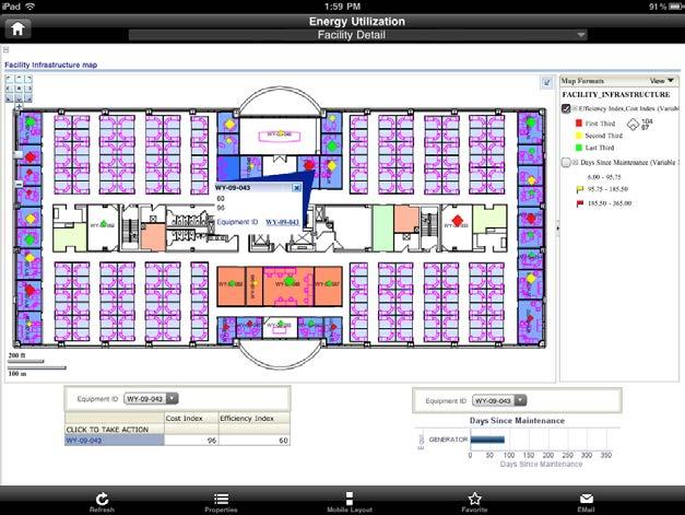
6 Why rename this Oracle Database option From Oracle Spatial to Oracle Spatial and Graph Highlights existing graph capabilities in Oracle Spatial W3C RDF graph since Oracle 10gR2 Network Data Model graph since Oracle 10gR1 Addresses increasing market demand for graph database capabilities Social Network Graph database popularity Multimodal and integrated transportation, utility and communications networks 6


7 Oracle Spatial and Graph option Points Web Services (OGC) Lines Oracle Spatial and Graph Polygons Geocoding Routing Rasters Network Graphs e1 f1 e2 n1 n2 f2 e4 e3 Topologies 3D RDF Semantic Graphs 7

 Network Data Model Graph Spatial Analysis Spatial Search")
 Indexing of 2D & 3D Full Coordinate")
8 Oracle Spatial and Graph option Spatial Features Spatial Data Types and Models 2D and 3D Geometries Raster Imagery and Gridded Data Land Management Persistent Topology Geographic and Whole Earth (Geodetic) Network Data Model Graph Spatial Analysis Spatial Search (Containment & Proximity) Geocoding (Address conversion) Routing (Turn by Turn directions) Indexing of 2D & 3D Full Coordinate System Support 8


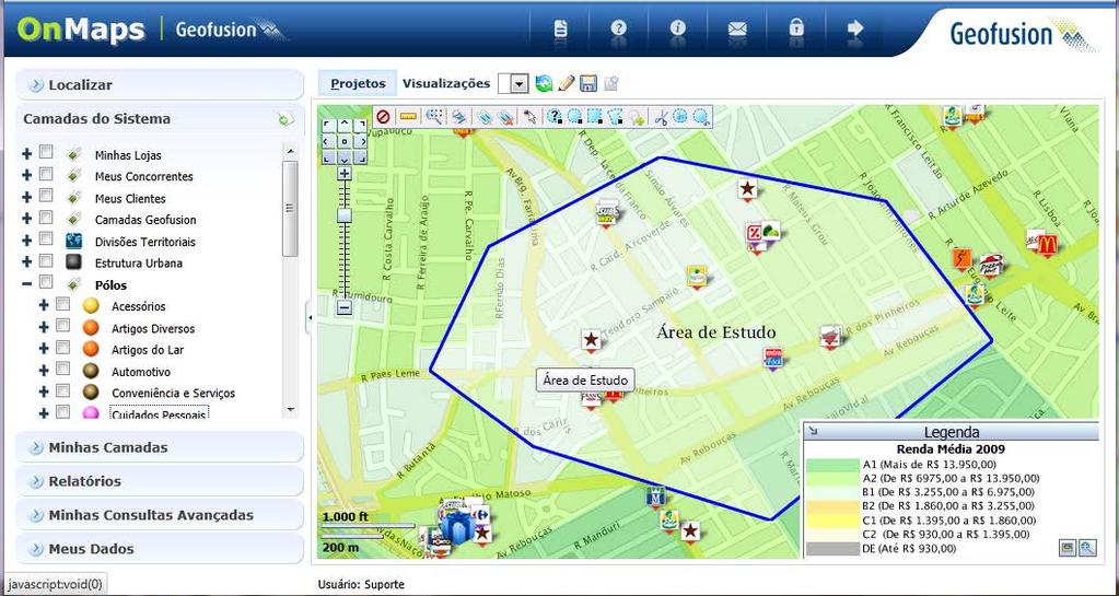
9 Oracle Spatial and Graph option Graph Features Network Data Model graph W3C RDF Semantic graph 9
10 Agenda Introduction Some Use Cases Discussion 10

11 Display application content and context 11

12 Reports in operational applications 12

13 Use in operational workflows Network Pinning and Work Tagging 13

14 Spatial visualization in interactive reports 14

15 Map views in BI dashboards 15
")


16 Usage Scenarios in (public sector) CRM Public safety Show incidents by type within or near specified location 16

17 Usage Scenarios in (public sector) CRM Show KPIs by service district 17

18 Geomarketing examples 18

19 TMC: Oracle SiteHub & Retail Analytics 19
20 20

21 Sales by store 21

22 Members who shopped at selected store 22

23 Where do the frequent customers live 23

24 Reports/analysis using drive-time polygons 24
")
25 Or by custom (user-drawn) areas 25


26 Solution architecture Client (browser) IsoChrone Area Editing IsoChrone OBI-Report Oracle WLS J2EE Container MapViewer NDM WithinCost Analysis Polygon Editing Jsp BI Publisher JDBC Oracle DBMS 11.2 Get the analysis area Bridge GeoBI Package SDO_Geom Package (Intersection, Union, Difference..) GeoDatawarehouse Schema Table 26

27 TARGUSinfo ElementOne Analytics OVERVIEW Comprehensive cloud based GIS analytics platform Provide rich data and cutting edge analytics to help clients acquire, retain and grow high value customers CHALLENGES / OPPORTUNITIES Ensure enterprise level security needs Provide mechanism for efficient and optimal data transfer Fast query response times for large customer and transaction level datasets Frequent, transparent software and data updates Quick and easy set up SOLUTION Oracle Database 11g Release 2 Enterprise Edition Spatial Option with GeoRaster, Network Data Model Partitioning Advanced Security Oracle Fusion Middleware 11g MapViewer RESULTS Up to10x performance improvement for detailed mapping with the use of MapViewer map cache Use of NDM partitioned blobs resulted in 300% quicker isochrone creation times while increasing accuracy Consolidation of raster, vector, network data in 500 GB sized central repository Utilize topology to maintain accurate geography relationships Improved base data precision with 25M+ ZIP4 level data 27

28 Use of Spatial LRS & Network Data Model Features used SDO_LRS to build comprehensive road network SDO_NET partitioning and load-on-demand for scalability and performance NDM APIs for custom costs and path analysis 28

29 Use of Oracle Spatial 11gR2 Features Advanced functions SDO_CS for transformations buffer, union, difference, convexhull etc for polygon generation sdo_validate, simplify, rectify_geom for cleansing sdo_tin for heatmaps 29
 5 mile Network Buffer generates all possible paths Each persisted path includes: Covered link IDs, nodes ID, and associated costs Single database query")
30 Large Scale Drive Time/Distance Analysis For millions of customers, find closest store within a specified drive time Same underlying data for geocoder and road network Customers geocode as link id and percentage (instead of longitude/latitude) 5 mile Network Buffer generates all possible paths Each persisted path includes: Covered link IDs, nodes ID, and associated costs Single database query to find closest store, and drive time, for each customer (join on link_id) Store Location Customer Location 30

31 Benefits with Parallel Query, Exadata Database Machine 31
32 Parallel Query and Spatial Rail Application 32
33 Parallel Query And Spatial Operators Rail Application Requirement GPS locations for each train collected throughout the day Each location has other attributes (time, speed, and more) GPS locations have a degree of error, so they don t always fall on a track. Bulk nearest neighbor queries to find closest track, and project reported train positions onto tracks This information is used for: Tracking trains Analysis for maintenance, ensure engineers are within parameters,etc 33
34 Parallel Query And Spatial Operators What we tested 45,158,800 GPS train positions. For each train position: Find the closest track to the train (with SDO_NN) Then calculate the position on the track closest to the train 34
35 Parallel Query And Spatial Operators Rail Application ALTER SESSION FORCE PARALLEL ddl PARALLEL 72; ALTER SESSION FORCE PARALLEL query PARALLEL 72; CREATE TABLE results NOLOGGING SELECT /*+ ordered index (b tracks_spatial_idx) */ a.locomotive_id, sdo_lrs.find_measure (b.track_geom, a.locomotive_pos) FROM locomotives a, tracks b WHERE sdo_nn (b.track_geom, a.locomotive_pos, 'sdo_num_res=1') ='TRUE'; 35
36 Parallel Query And Spatial Operators Exadata Results On Exadata Half RAC: hours serially vs minutes in parallel 48 database cores - 47x faster On Exadata X2-2 Full Rack 96 database cores about 94x faster X2-8 (128 cores) even faster 36
37 Parallel Query and Spatial Validation Of Home Appraisals 37
38 Validation Of Home Appraisals Exadata Results Validate home appraisals for a Government Sponsored Enterprise (GSE) Requirement - Find all the parcels touching parcels to validate appraisals Processed 2,018,429 parcels Exadata ½ RAC: Serially minutes Parallel - 48 cores (45x faster) - 50 seconds Exadata X2-2 Full RAC (96 cores) about 90x faster Exadata X2-8 (128 cores) even faster 38
39 Parallel Query and Spatial Parallel Enabled Pipeline Table Functions 39
40 Parallel Enabled Pipeline Table Function Parallelize a function that s called a massive amount of times. Batch geocoding (sdo_gcdr.geocode_address) Batch reverse geocoding (sdo_gcdr.reverse_geocode) Batch Digital Elevation Model (DEM) raster lookups (sdo_geor.get_cell_value) Pipeline Table Function returns a table of results Table of geocodes Table of reverse geocodes Table of elevation values 40
41 Parallel Enabled Pipeline Table Function How does it work? Define cursor that selects the input to the batch process: SELECT customer_addresses FROM address_table WHERE state = NY ; SELECT vehicle_location FROM vehicles WHERE sdo_anyinteract (location,:region) = TRUE Parallel Query distributes the batch process over a specified number of database cores. 41
42 Parallel Enabled Pipeline Table Function Exadata ¼ RAC has 2 nodes, each with 12 cores (24 cores total) ALTER SESSION FORCE PARALLEL DML PARALLEL 24; ALTER SESSION FORCE PARALLEL QUERY PARALLEL 24; -- To balance parallel slaves across nodes. ALTER SESSION SET "_parallel_load_balancing"=false; CREATE TABLE results (id NUMBER, geom SDO_GEOMETRY); INSERT /*+ append */ INTO results SELECT id, sdo_geometry (2001,8307,sdo_point_type(longitude,latitude,null),null,null) geom FROM table( geocode_pipelined ( CURSOR(SELECT id, streetname, city, state, zip, housenum FROM ascii_addrs) )); COMMIT; 42
43 Parallel Enabled Pipeline Table Function To Maximize Exadata ¼ RAC (24 cores) ALTER SESSION FORCE PARALLEL DML PARALLEL 48; ALTER SESSION FORCE PARALLEL QUERY PARALLEL 48; CREATE TABLE results (id NUMBER, geom SDO_GEOMETRY); INSERT /*+ append */ INTO results SELECT id, sdo_geometry (2001,8307,sdo_point_type(longitude,latitude,null),null,null) geom FROM table( geocode_pipelined ( CURSOR(SELECT id, streetname, city, state, zip, housenum FROM ascii_addrs) )); COMMIT; 43
44 Parallel Pipelined Table Function Exadata Results Exadata ¼ RAC Has 24 Cores Batch geocoding 1365/second Batch reverse geocoding 3388/second Batch DEM get_cell_value raster lookups 8951/second 44
45 Q&A 45
May 22, 2013 Ronald Reagan Building and International Trade Center Washington, DC USA
 May 22, 2013 Ronald Reagan Building and International Trade Center Washington, DC USA 1 To 9. D 1. 2. 3. Performance, Performance, Performance What You Need To Know About Exadata Daniel Geringer Senior
May 2012 Oracle Spatial User Conference
 1 May 2012 Oracle Spatial User Conference May 23, 2012 Ronald Reagan Building and International Trade Center Washington, DC USA Daniel Geringer Senior Software Development Manager Oracle s Spatial Technologies
Big Spatial Data Performance With Oracle Database 12c. Daniel Geringer Spatial Solutions Architect
 Big Spatial Data Performance With Oracle Database 12c Daniel Geringer Spatial Solutions Architect Oracle Exadata Database Machine Engineered System 2 What Is the Oracle Exadata Database Machine? Oracle
1 Copyright 2011, Oracle and/or its affiliates. All rights reserved.
 1 Copyright 2011, Oracle and/or its affiliates. All rights reserved. ORACLE PRODUCT LOGO S15402 Google Maps, ESRI, Traffic, ipad: Bring it all Together With Oracle Spatial LJ Qian Jayant Sharma Sr. Mgr.,
May 2012 Oracle Spatial User Conference
 1 May 2012 Oracle Spatial User Conference May 23, 2012 Ronald Reagan Building and International Trade Center Washington, DC USA Michele Sacchi Bridge Consulting Program Manager Geomarketing Analysis A
Oracle Spatial Summit 2015 Best Practices for Developing Geospatial Apps for the Cloud
 Oracle Spatial Summit 2015 Best Practices for Developing Geospatial Apps for the Cloud Nick Salem, Distinguished Engineer Neustar Neustar ElementOne OVERVIEW Comprehensive cloud based GIS analytics platform
Oracle Spatial Technologies: An Update. Xavier Lopez Director, Spatial Technologies Oracle Corporation
 Oracle Spatial Technologies: An Update Xavier Lopez Director, Spatial Technologies Oracle Corporation Overview Oracle Approach to Market Specialist v. Generalist Solutions New Developments: Oracle Database
DOAG CONFERENCE Data Warehouse & Business Intelligence. November 22, 2012 NürnbergConvention Center Ost Nürnberg
 November 2012 DOAG CONFERENCE Data Warehouse & Business Intelligence November 22, 2012 NürnbergConvention Center Ost Nürnberg Michele Sacchi Bridge Consulting Program Manager Geomarketing Analysis A developed
May 2012 Oracle Spatial User Conference
 1 May 2012 Oracle Spatial User Conference May 23, 2012 Ronald Reagan Building and International Trade Center Washington, DC USA Siva Ravada Director of Development Oracle Spatial Steve MacCabe Product
Land Information Management and its (3D) Database Foundation
 Database Foundation") Land Information Management and its (3D) Database Foundation Han Wammes, Oracle Netherlands November 18 th, 2011 1 Copyright 2011, Oracle and/or its affiliates. All rights Safe Harbor Statement The following
Land Information Management and its (3D) Database Foundation Han Wammes, Oracle Netherlands November 18 th, 2011 1 Copyright 2011, Oracle and/or its affiliates. All rights Safe Harbor Statement The following
May 22, 2013 Ronald Reagan Building and International Trade Center Washington, DC USA
 May 22, 2013 Ronald Reagan Building and International Trade Center Washington, DC USA Scott Gooding Spatial Database Architect CSX Rail: Implementation of Oracle s Spatial Routing, Geocoding, LRS and NDM
Copyright 2013, Oracle and/or its affiliates. All rights reserved.
 1 What s New in Location Analytics Jayant Sharma Director, Product Mgmt The following is intended to outline our general product direction. It is intended for information purposes only, and may not be
Copyright 2012, Oracle and/or its affiliates. All rights reserved.
 1 Oracle Spatial and Graph: Faster, Bigger, Better 2-D and 3-D Spatial Solutions Siva Ravada Senior Director of Development Spatial and Graph & MapViewer 2 The following is intended to outline our general
Copyright 2012, Oracle and/or its affiliates. All rights reserved.
 1 The following is intended to outline our general product direction. It is intended for information purposes only, and may not be incorporated into any contract. It is not a commitment to deliver any
May 22, 2013 Ronald Reagan Building and International Trade Center Washington, DC USA
 May 22, 2013 Ronald Reagan Building and International Trade Center Washington, DC USA 1 To 9. D 1. 2. 3. Leveraging Advanced Oracle Spatial and Graph Features Daniel Geringer Senior Software Development
May 2013 Oracle Spatial and Graph User Conference
 May 2013 Oracle Spatial and Graph User Conference May 22, 2013 Ronald Reagan Building and International Trade Center Washington, DC USA Paul Calhoun & Vince Smith GIS Systems Analyst City Of Virginia Beach
Deploying Spatial Applications in Oracle Public Cloud
 Deploying Spatial Applications in Oracle Public Cloud David Lapp, Product Manager Oracle Spatial and Graph Oracle Spatial Summit at BIWA 2017 Safe Harbor Statement The following is intended to outline
ArcGIS Enterprise: An Introduction. Philip Heede
 Enterprise: An Introduction Philip Heede Online Enterprise Hosted by Esri (SaaS) - Upgraded automatically (by Esri) - Esri controls SLA Core Web GIS functionality (Apps, visualization, smart mapping, analysis
IT Infrastructure for BIM and GIS 3D Data, Semantics, and Workflows
 IT Infrastructure for BIM and GIS 3D Data, Semantics, and Workflows Hans Viehmann Product Manager EMEA ORACLE Corporation November 23, 2017 @SpatialHannes Safe Harbor Statement The following is intended
Oracle Enterprise Data Quality - Roadmap
 Oracle Enterprise Data Quality - Roadmap Mike Matthews Martin Boyd Director, Product Management Senior Director, Product Strategy Copyright 2014 Oracle and/or its affiliates. All rights reserved. Oracle
Convergence and Collaboration: Transforming Business Process and Workflows
 Convergence and Collaboration: Transforming Business Process and Workflows Steven Hagan, Vice President, Server Technologies 1 Copyright 2011, Oracle and/or its affiliates. All rights Convergence & Collaboration:
Safe Harbor Statement
 Safe Harbor Statement The following is intended to outline our general product direction. It is intended for information purposes only, and may not be incorporated into any contract. It is not a commitment
Best Practices, Tips and Tricks With Oracle Spatial and Graph Daniel Geringer, Spatial Solutions Specialist Oracle Corporation
 Best Practices, Tips and Tricks With Oracle Spatial and Graph Daniel Geringer, Spatial Solutions Specialist Oracle Corporation Spatial Vector Acceleration Oracle Confidential Internal/Restricted/Highly
An Introduction to Oracle s Location Technologies ORACLE WHITE PAPER MARCH 2017
 An Introduction to Oracle s Location Technologies ORACLE WHITE PAPER MARCH 2017 Disclaimer The following is intended to outline our general product direction. It is intended for information purposes only,
Introduction to Geodatabase and Spatial Management in ArcGIS. Craig Gillgrass Esri
 Introduction to Geodatabase and Spatial Management in ArcGIS Craig Gillgrass Esri Session Path The Geodatabase - What is it? - Why use it? - What types are there? - What can I do with it? Query Layers
Land Administration and Management: Big Data, Fast Data, Semantics, Graph Databases, Security, Collaboration, Open Source, Shareable Information
 Land Administration and Management: Big Data, Fast Data, Semantics, Graph Databases, Security, Collaboration, Open Source, Shareable Information Platform Steven Hagan, Vice President, Engineering 1 Copyright
Georeferencing. Georeferencing: = linking a layer or dataset with spatial coordinates. Registration: = lining up layers with each other
 Georeferencing How do we make sure all our data layers line up? Georeferencing: = linking a layer or dataset with spatial coordinates Registration: = lining up layers with each other Rectification: The
Oracle 10g GeoSpatial Technologies. Eve Kleiman Asia/Pacific Spatial Product Manager Oracle Corporation
 Oracle 10g GeoSpatial Technologies Eve Kleiman Asia/Pacific Spatial Product Manager Oracle Corporation Eve.Kleiman@oracle.com Agenda Market and Technology Trends Oracle GeoSpatial Technology Stack What
Oracle Spatial Summit 2015 Effectively Integrate Geospatial Technologies from GIS to Oracle Spatial in Real Estate Sector
 Effectively Integrate Geospatial Technologies from GIS to in Real Estate Sector Francisco Javier Rojas Duran, IT Project Manager Professional DASOFT DASOFT RUV (Housing Registry Authority) - SACP OVERVIEW
1 Copyright 2011, Oracle and/or its affiliates. All rights reserved.
 1 Copyright 2011, Oracle and/or its affiliates. All rights reserved. Integrating Complex Financial Workflows in Oracle Database Xavier Lopez Seamus Hayes Oracle PolarLake, LTD 2 Copyright 2011, Oracle
Copyright 2012, Oracle and/or its affiliates. All rights reserved.
 1 Oracle Spatial and Graph: Technologies 101 Xavier Lopez, Senior Director Product Management, Oracle Server Technologies 2 Program Agenda Introducing Oracle Spatial and Graph Advanced Features New Features
Verarbeitung von Vektor- und Rasterdaten auf der Hadoop Plattform DOAG Spatial and Geodata Day 2016
 Verarbeitung von Vektor- und Rasterdaten auf der Hadoop Plattform DOAG Spatial and Geodata Day 2016 Hans Viehmann Product Manager EMEA ORACLE Corporation 12. Mai 2016 Safe Harbor Statement The following
May 21, 2014 Walter E. Washington Convention Center Washington, DC USA. Copyright 2014, Oracle and/or its affiliates. All rights reserved.
 May 21, 2014 Walter E. Washington Convention Center Washington, DC USA 1 How to Build a Better GIS Application Siva Ravada Senior Director of Development Spatial and Graph & MapViewer Oracle Program Agenda
Key Terms. Attribute join Target table Join table Spatial join
 Key Terms Attribute join Target table Join table Spatial join Lect 10A Building Geodatabase Create a new file geodatabase Map x,y data Convert shape files to geodatabase feature classes Spatial Data Formats
Large-Scale Patch Automation for the Cloud-Generation DBAs
 Large-Scale Patch Automation for the Cloud-Generation DBAs Pankaj Chandiramani Principal Product Manager, Oracle Sean Connolly Software Development Director, Oracle Steven Meredith EM Service Manager,
SQL Gone Wild: Taming Bad SQL the Easy Way (or the Hard Way) Sergey Koltakov Product Manager, Database Manageability
 Sergey Koltakov Product Manager, Database Manageability") SQL Gone Wild: Taming Bad SQL the Easy Way (or the Hard Way) Sergey Koltakov Product Manager, Database Manageability Oracle Enterprise Manager Top-Down, Integrated Application Management Complete, Open,
SQL Gone Wild: Taming Bad SQL the Easy Way (or the Hard Way) Sergey Koltakov Product Manager, Database Manageability Oracle Enterprise Manager Top-Down, Integrated Application Management Complete, Open,
An Oracle White Paper January Oracle Fusion Middleware MapViewer 10g ( )
") An Oracle White Paper January 2009 Oracle Fusion Middleware MapViewer 10g (10.1.3.3) Oracle Fusion Middleware MapViewer Disclaimer The following is intended to outline our general product direction. It
An Oracle White Paper January 2009 Oracle Fusion Middleware MapViewer 10g (10.1.3.3) Oracle Fusion Middleware MapViewer Disclaimer The following is intended to outline our general product direction. It
Oracle Spatial Best Practices and Tuning Tips for DBAs and Developers
 Oracle Spatial Best Practices and Tuning Tips for DBAs and Developers Daniel Geringer Senior Software Development Manager Oracle s Spatial Technologies Spatial Data Validation VALIDATE_GEOMETRY_WITH_CONTEXT
Oracle Spatial 10g: Advanced
 Oracle Spatial 10g: Advanced Volume I Student Guide D18959GC20 Edition 2.0 November 2005 D22663 Author Daniel Abugov Daniel Geringer Technical Contributors and Reviewers Thomas Hoogerwerf Christine Jeal
Copyright 2012, Oracle and/or its affiliates. All rights reserved.
 1 Oracle Spatial and Graph at OOW 2012 Sessions Date/Time Title Location Tuesday, Oct 2 8:30am-9:30am 10:15am-11:15am 10:15am-11:15am Wednesday, Oct 3 11:45am - 12:45pm 1:15pm-2:15pm JavaOne Session: Leveraging
ORACLE FUSION MIDDLEWARE MAPVIEWER
 ORACLE FUSION MIDDLEWARE MAPVIEWER 10.1.3.3 MAPVIEWER KEY FEATURES Component of Fusion Middleware Integration with Oracle Spatial, Oracle Locator Support for two-dimensional vector geometries stored in
Understanding Oracle RAC ( ) Internals: The Cache Fusion Edition
 Internals: The Cache Fusion Edition") Understanding (12.1.0.2) Internals: The Cache Fusion Edition Subtitle Markus Michalewicz Director of Product Management Oracle Real Application Clusters (RAC) November 19th, 2014 @OracleRACpm http://www.linkedin.com/in/markusmichalewicz
Understanding (12.1.0.2) Internals: The Cache Fusion Edition Subtitle Markus Michalewicz Director of Product Management Oracle Real Application Clusters (RAC) November 19th, 2014 @OracleRACpm http://www.linkedin.com/in/markusmichalewicz
Oracle and Tangosol Acquisition Announcement
 Oracle and Tangosol Acquisition Announcement March 23, 2007 The following is intended to outline our general product direction. It is intended for information purposes only, and may
Automating Information Lifecycle Management with
 Automating Information Lifecycle Management with Oracle Database 2c The following is intended to outline our general product direction. It is intended for information purposes only, and may not be incorporated
Map Visualization in Analytic Applications LJ Qian, Director of Software Development David Lapp, Product Manager Oracle
 Map Visualization in Analytic Applications LJ Qian, Director of Software Development David Lapp, Product Manager Oracle Copyright 2015, Oracle and/or its affiliates. All rights reserved. Safe Harbor Statement
Spatial and Graph Analytics with Oracle Database 12c Release 2 ORACLE WHITE PAPER MARCH 2017
 Spatial and Graph Analytics with Oracle Database 12c Release 2 ORACLE WHITE PAPER MARCH 2017 Disclaimer The following is intended to outline our general product direction. It is intended for information
Real Time Summarization. Copyright 2014, Oracle and/or its affiliates. All rights reserved.
 Real Time Summarization Safe Harbor Statement The following is intended to outline our general product direction. It is intended for information purposes only, and may not be incorporated into any contract.
Improving Your Business with Oracle Data Integration See How Oracle Enterprise Metadata Management Can Help You
 Improving Your Business with Oracle Data Integration See How Oracle Enterprise Metadata Management Can Help You Özgür Yiğit Oracle Data Integration, Senior Manager, ECEMEA Safe Harbor Statement The following
Visualizing Data Using Maps in OBI 11g
 Copyright 2010, Vlamis Software Solutions, Inc. Visualizing Data Using Maps in OBI 11g Collaborate 2011 Tim Vlamis Vlamis Software Solutions 816-781-2880 http://www.vlamis.com Copyright 2010, Vlamis Software
Technology for Cadastral Applications. John R. Hacker, Jr. Marketing Manager Geospatial Applications
 Technology for Cadastral Applications John R. Hacker, Jr. Marketing Manager Geospatial Applications Agenda Cadastral Mapping Issues Precision and Accuracy Data Creation Data Management Data Publishing
Evolving To The Big Data Warehouse
 Evolving To The Big Data Warehouse Kevin Lancaster 1 Copyright Director, 2012, Oracle and/or its Engineered affiliates. All rights Insert Systems, Information Protection Policy Oracle Classification from
Copyright 2013, Oracle and/or its affiliates. All rights reserved. Insert Information Protection Policy Classification from Slide 12
 1 Information Retention and Oracle Database Kevin Jernigan Senior Director Oracle Database Performance Product Management The following is intended to outline our general product direction. It is intended
May 2012 Oracle Spatial User Conference
 1 May 2012 Oracle Spatial User Conference May 23, 2012 Ronald Reagan Building and International Trade Center Washington, DC USA Andrew Howles & Jo Shannon IS Principal Architect General Manager, Operations
1 Dulcian, Inc., 2001 All rights reserved. Oracle9i Data Warehouse Review. Agenda
 Agenda Oracle9i Warehouse Review Dulcian, Inc. Oracle9i Server OLAP Server Analytical SQL Mining ETL Infrastructure 9i Warehouse Builder Oracle 9i Server Overview E-Business Intelligence Platform 9i Server:
Oracle Spatial 11g: Build Web Services, GeoRaster, Network and 3D Applications Dr. Siva Ravada Director of Development Oracle
 Oracle Spatial 11g: Build Web Services, GeoRaster, Network and 3D Applications Dr. Siva Ravada Director of Development Oracle Oracle Spatial Features Oracle Locator: Feature of Oracle Database XE, SE,
Moving Databases to Oracle Cloud: Performance Best Practices
 Moving Databases to Oracle Cloud: Performance Best Practices Kurt Engeleiter Product Manager Oracle Safe Harbor Statement The following is intended to outline our general product direction. It is intended
Javaentwicklung in der Oracle Cloud
 Javaentwicklung in der Oracle Cloud Sören Halter Principal Sales Consultant 2016-11-17 Safe Harbor Statement The following is intended to outline our general product direction. It is intended for information
The Oracle Enterprise Geodatabase (EGDB) Charlie Crocker Farallon Geographics, Inc.
 Charlie Crocker Farallon Geographics, Inc.") The Oracle Enterprise Geodatabase (EGDB) Charlie Crocker Farallon Geographics, Inc. www.fargeo.com Norcal URISA Chapter Meeting 2/9/2005 Todays Goals Enterprise geodatabase defined Roles Oracle can play
The Oracle Enterprise Geodatabase (EGDB) Charlie Crocker Farallon Geographics, Inc. www.fargeo.com Norcal URISA Chapter Meeting 2/9/2005 Todays Goals Enterprise geodatabase defined Roles Oracle can play
Welkom bij de themasessie Oracle Spatial 11g
 Welkom bij de themasessie Oracle Spatial 11g OGh SIM Commissie Agenda 19:00-19:05 Welkom 19:05-19:35 Managing ALL your Information in 11g (Han Wammes) 19:35-20:15 Oracle Spatial 11g
Oracle WebCenter Portal Performance Tuning
 ORACLE PRODUCT LOGO Oracle WebCenter Portal Performance Tuning Rich Nessel - Principal Product Manager Christina Kolotouros - Product Management Director 1 Copyright 2011, Oracle and/or its affiliates.
Oracle Spatial 10g: Platform for Enterprise Geospatial Solutions
 11/30/2005-8:00 am - 9:30 am Room:Macaw 1/2 (Swan) Walt Disney World Swan and Dolphin Resort Orlando, Florida Oracle Spatial 10g: Platform for Enterprise Geospatial Solutions Xavier Lopez - Oracle USA,
MDM Partner Summit 2015 Oracle Enterprise Data Quality Overview & Roadmap
 MDM Partner Summit 2015 Oracle Enterprise Data Quality Overview & Roadmap Steve Tuck Senior Director, Product Strategy Todd Blackmon Senior Director, Sales Consulting David Gengenbach Sales Consultant
May 21, 2014 Walter E. Washington Convention Center Washington, DC USA. Copyright 2014, Oracle and/or its affiliates. All rights reserved.
 May 21, 2014 Walter E. Washington Convention Center Washington, DC USA 1 Innovation in Spatial Data Processing Hans Viehmann Product Manager EMEA The following is intended to outline our general product
Security Compliance and Data Governance: Dual problems, single solution CON8015
 Security Compliance and Data Governance: Dual problems, single solution CON8015 David Wolf Director of Product Management Oracle Development, Enterprise Manager Steve Ries Senior Systems Architect Technology
Insider s Guide on Using ADO with Database In-Memory & Storage-Based Tiering. Andy Rivenes Gregg Christman Oracle Product Management 16 November 2016
 Insider s Guide on Using ADO with Database In-Memory & Storage-Based Tiering Andy Rivenes Gregg Christman Oracle Product Management 16 November 2016 Safe Harbor Statement The following is intended to outline
Oracle Big Data Spatial and Graph: Spatial Features
 Oracle Big Data Spatial and Graph: Spatial Features January 28 th, 2016 Siva Ravada Senior Director of Development Copyright 2015, Oracle and/or its affiliates. All rights reserved. Program Agenda 1 2
Pimp My Data Grid. Brian Oliver Senior Principal Solutions Architect <Insert Picture Here>
 Pimp My Data Grid Brian Oliver Senior Principal Solutions Architect (brian.oliver@oracle.com) Oracle Coherence Oracle Fusion Middleware Agenda An Architectural Challenge Enter the
ORACLE SPATIAL DATABASE WITH MAPVIEWER AND MAP BUILDER FOR DESGINING SPATIAL APPLICATION OF THAPAR UNIVERSITY
 ORACLE SPATIAL DATABASE WITH MAPVIEWER AND MAP BUILDER FOR DESGINING SPATIAL APPLICATION OF THAPAR UNIVERSITY Thesis submitted in partial fulfillment of the requirements for the award of degree of Master
Oracle WebCenter Interaction: Roadmap for BEA AquaLogic User Interaction. Ajay Gandhi Sr. Director of Product Management Enterprise 2.
 Oracle WebCenter Interaction: Roadmap for BEA AquaLogic User Interaction Ajay Gandhi Sr. Director of Product Management Enterprise 2.0 and Portals 1 Agenda Enterprise 2.0 and Portal Product Strategy AquaLogic
DBAs can use Oracle Application Express? Why?
 DBAs can use Oracle Application Express? Why? 20. Jubilarna HROUG Konferencija October 15, 2015 Joel R. Kallman Director, Software Development Oracle Application Express, Server Technologies Division Copyright
Oracle Database 10g: Managing Spatial Raster Data Using GeoRaster. An Oracle Technical White Paper May 2005
 Oracle Database 10g: Managing Spatial Raster Data Using GeoRaster An Oracle Technical White Paper May 2005 Managing Spatial Raster Data Using GeoRaster Table of Contents 1 GeoRaster... 3 1.1 Introduction...
<Insert Picture Here> Introduction to Big Data Technology
 Introduction to Big Data Technology The following is intended to outline our general product direction. It is intended for information purposes only, and may not be incorporated into
Oracle APEX 18.1 New Features
 Oracle APEX 18.1 New Features May, 2018 Safe Harbor Statement The following is intended to outline our general product direction. It is intended for information purposes only, and may not be incorporated
2-4 April 2019 Taets Art and Event Park, Amsterdam CLICK TO KNOW MORE
 Co-Host Host 2-4 April 2019 Taets Art and Event Park, Amsterdam CLICK TO KNOW MORE Oracle Cloud Computing Strategy Han Wammes Public Sector Market Development Manager 1 Copyright 2012, Oracle and/or its
Solaris Engineered Systems
 Solaris Engineered Systems SPARC SuperCluster Introduction Andy Harrison andy.harrison@oracle.com Engineered Systems, Revenue Product Engineering The following is intended to outline
Publishing Statistical Data and Geospatial Data as Linked Data Creating a Semantic Data Platform
 Publishing Statistical Data and Geospatial Data as Linked Data Creating a Semantic Data Platform Hans Viehmann Product Manager EMEA ORACLE Corporation January 22, 2017 @SpatialHannes Safe Harbor Statement
Using Linked Data Concepts to Blend and Analyze Geospatial and Statistical Data Creating a Semantic Data Platform
 Using Linked Data Concepts to Blend and Analyze Geospatial and Statistical Data Creating a Semantic Data Platform Hans Viehmann Product Manager EMEA ORACLE Corporation October 17, 2018 @SpatialHannes Safe
Copyright 2012, Oracle and/or its affiliates. All rights reserved.
 1 Oracle NoSQL Database and Oracle Relational Database - A Perfect Fit Dave Rubin Director NoSQL Database Development 2 The following is intended to outline our general product direction. It is intended
GeoSPARQL Support and Other Cool Features in Oracle 12c Spatial and Graph Linked Data Seminar Culture, Base Registries & Visualisations
 GeoSPARQL Support and Other Cool Features in Oracle 12c Spatial and Graph Linked Data Seminar Culture, Base Registries & Visualisations Hans Viehmann Product Manager EMEA Oracle Corporation December 2,
Oracle Spatial User Conference Presentation Template
 Oracle Spatial User Conference Presentation Template Lindsey M Pickle, Jr. Director World Wide Alliances and Channels Database Technologies Get Specialized Oracle Partner Specialization Program Agenda
Copyright 2012, Oracle and/or its affiliates. All rights reserved.
 1 Oracle Data Guard 12c Zero Data Loss at Any Distance Joseph Meeks Director of Product Management, Oracle Madhu Tumma Technology Director, J P Morgan Chase 2 Program Agenda Zero Data Loss Disaster Protection
Copyright 2012, Oracle and/or its affiliates. All rights reserved.
 1 Big Data Connectors: High Performance Integration for Hadoop and Oracle Database Melli Annamalai Sue Mavris Rob Abbott 2 Program Agenda Big Data Connectors: Brief Overview Connecting Hadoop with Oracle
What every DBA needs to know about JDBC connection pools Bridging the language barrier between DBA and Middleware Administrators
 Presented at What every DBA needs to know about JDBC connection pools Bridging the language barrier between DBA and Middleware Administrators Jacco H. Landlust Platform Architect Director Oracle Consulting
Getting Started with ArcGIS for Server. Charmel Menzel and Ken Gorton
 Getting Started with ArcGIS for Server Charmel Menzel and Ken Gorton Agenda What is ArcGIS for Server? Types of Web services Publishing resources onto the Web Clients to ArcGIS for Server Editions and
VECTOR ANALYSIS: QUERIES, MEASUREMENTS & TRANSFORMATIONS
 VECTOR ANALYSIS: QUERIES, MEASUREMENTS & TRANSFORMATIONS GIS Analysis Winter 2016 Spatial Analysis Operations performed on spatial data that add value Can reveal things that might otherwise be invisible
Massive Scalability With InterSystems IRIS Data Platform
 Massive Scalability With InterSystems IRIS Data Platform Introduction Faced with the enormous and ever-growing amounts of data being generated in the world today, software architects need to pay special
1 Copyright 2011, Oracle and/or its affiliates. All rights reserved.
 1 Copyright 2011, Oracle and/or its affiliates. All rights reserved. Re-Engineering Your Database Design with Oracle SQL Developer Data Modeler Swarnapriya Shridhar Curriculum IDC Operations Manager 2
Lecture 6: GIS Spatial Analysis. GE 118: INTRODUCTION TO GIS Engr. Meriam M. Santillan Caraga State University
 Lecture 6: GIS Spatial Analysis GE 118: INTRODUCTION TO GIS Engr. Meriam M. Santillan Caraga State University 1 Spatial Data It can be most simply defined as information that describes the distribution
Introduction to Geographic Information Science. Some Updates. Last Lecture 4/6/2017. Geography 4103 / Raster Data and Tesselations.
 Geography 43 / 3 Introduction to Geographic Information Science Raster Data and Tesselations Schedule Some Updates Last Lecture We finished DBMS and learned about storage of data in complex databases Relational
GIS Basics for Urban Studies
 GIS Basics for Urban Studies Date: March 21, 2018 Contacts: Mehdi Aminipouri, Graduate Peer GIS Faciliator, SFU Library (maminipo@sfu.ca) Keshav Mukunda, GIS & Map Librarian Librarian for Geography (kmukunda@sfu.ca)
ArcGIS Runtime SDK for ios and macos: Building Apps. Suganya Baskaran, Gagandeep Singh
 ArcGIS Runtime SDK for ios and macos: Building Apps Suganya Baskaran, Gagandeep Singh Get Started Core Components Agenda - Display Map Content - Search for Content - Perform Analysis - Edit Content Summary
An Oracle White Paper September Oracle Fusion Middleware MapViewer
 An Oracle White Paper September 2014 Oracle Fusion Middleware MapViewer Introduction... 2 Usage Scenarios... 3 Reporting... 3 Proximity Search... 4 Analysis... 5 Brief Feature Overview... 8 Developing
BEST PRACTICES FOR DEVELOPING GEOSPATIAL BIG DATA APPS FOR THE CLOUD. Nick Salem - Distinguished Engineer David Tatar - Principal Software Engineer
 BEST PRACTICES FOR DEVELOPING GEOSPATIAL BIG DATA APPS FOR THE CLOUD Nick Salem - Distinguished Engineer David Tatar - Principal Software Engineer SPEAKER BIO NICK SALEM 18 Oracle Certified Professional
<Insert Picture Here> What's New for.net Developers for Oracle Database
 1 What's New for.net Developers for Oracle Database Alex Keh Principal Product Manager, Oracle Program Agenda Currently available Visual Studio 2010 and.net Framework 4 ODAC 11.2
Announcements. Data Sources a list of data files and their sources, an example of what I am looking for:
 Data Announcements Data Sources a list of data files and their sources, an example of what I am looking for: Source Map of Bangor MEGIS NG911 road file for Bangor MEGIS Tax maps for Bangor City Hall, may
1Copyright 2012, Oracle and/or its affiliates. All rights reserved.
 1Copyright 2012, Oracle and/or its affiliates. All rights reserved. Patterns of SaaS: Database refactoring Leonid Igolnik, Marcin Burlinski Insert Picture Here The following is intended to outline our
What s New in MySQL 5.7 Geir Høydalsvik, Sr. Director, MySQL Engineering. Copyright 2015, Oracle and/or its affiliates. All rights reserved.
 What s New in MySQL 5.7 Geir Høydalsvik, Sr. Director, MySQL Engineering Safe Harbor Statement The following is intended to outline our general product direction. It is intended for information purposes
US Census Bureau Geographic Support System Initiative Partnership Program
 OVERVIEW Centrally managed, authoritative database (MAF/TIGER) Centrally managed Partnership Program SDE geodatabase Supports all censuses and surveys CHALLENGES / OPPORTUNITIES Need for centralized repository
Oracle #1 RDBMS Vendor
 Oracle #1 RDBMS Vendor IBM 20.7% Microsoft 18.1% Other 12.6% Oracle 48.6% Source: Gartner DataQuest July 2008, based on Total Software Revenue Oracle 2 Continuous Innovation Oracle 11g Exadata Storage
GEOINDEX - A NEW GEOLOCATION METHODOLOGY
 GEOINDEX - A NEW GEOLOCATION METHODOLOGY Matthew Hudnall Presentation to the 2014 GIS-T Conference Burlington, VT May 8, 2014 CENTER FOR ADVANCED PUBLIC SAFETY Works with: State, federal and local agencies