Georeferencing. Georeferencing: = linking a layer or dataset with spatial coordinates. Registration: = lining up layers with each other
|
|
|
- Kevin Payne
- 5 years ago
- Views:
Transcription

1 Georeferencing How do we make sure all our data layers line up? Georeferencing: = linking a layer or dataset with spatial coordinates Registration: = lining up layers with each other Rectification: The process by which the geometry of an image is made planimetric
2 Georeferencing To georeference the act of assigning locations to atoms of information Is essential in GIS, since all information must be linked to the Earth s surface The method of georeferencing must be: Unique, linking information to exactly one location Shared, so different users understand the meaning of a georeference Persistent through time, so today s georeferences are still meaningful tomorrow
3

4 Georeferencing Based on Data Types Raster and Raster Vector and Vector Raster and Vector
5
6
7
8
9
10
11
12
13
14

15
16
17 Geocoding Concepts and Definitions
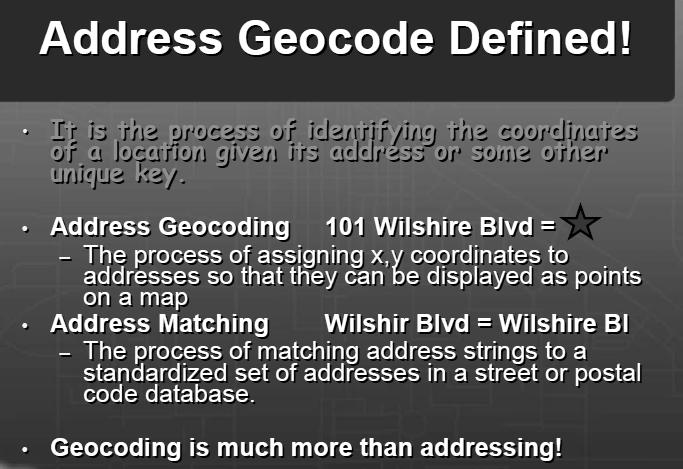
18 Definition of Geocoding Geocoding can be broadly defined as the assignment of a code to a geographic location. Usually however, Geocoding refers to a more specific assignment of geographic coordinates (latitude,longitude) to an individual address.. UN Report
19 Definition of Geocoding What is Geocoding Geocoding is a process of creating map features from addresses, place names, or similar textual information based on attributes associated with a referenced geographic database, typically a street network that has address ranges associated with each street segment or 'link' running from one intersection to the next.
20 Definition of Geocoding What is Geocoding Geocoding typically uses Interpolation as a method to find the location information about an address. (If the address along one side of a block range from 1 to 199, then Street Number = 66 is about one-third of the way along that side of the block.) Data required: Reasonably clean, consistent list of legal addresses (i.e. not too many typos, addresses really exist, etc.) Address range attributes on a linear street network» Most commonly from Census» More current/cleaner data available from private vendors
21 Georeferencing vs Geocoding Georeferencing Aligning geographic data to a known coordinate system so it can be analyzed, viewed, and queried with other geographic data Geocoding The process of assigning geographic codes to features in a digital database (including the GIS operation for converting street addresses into spatial data that can be displayed as features on a map)
22

23

24
25 Data Collection Methods Two main methods: Direct Collection Approach Matching Approach

26 Direct Collection Approach Digitizing from available topographic maps Direct collection using field techniques (ex.gps) Digitizing from a topographic map Global Positioning System (GPS) Areas, Street, Dwelling
27 Matching approach Using an Address locator database and street network database in a GIS Joining an address database to an existing spatial database for the area of interest First Avenue Street Network Left of Street #1 address number #99 Main Street #2 #100 Right of Street Second Avenue First Avenue Street Segment Left of Street #1 #51 #99 #2 #32 #100 Right of Street Nodes Second Avenue
28 Address Databases
29 Address Database Another Geocoding Definitions Address Geocoding - Assigning X,Y coordinates to tabular data such as street addresses or zip codes so that they may be displayed as points on a map. Address Parity - Evenness or oddness. In address geocoding, parity is used to locate an address on the correct side of the street. Such as, odd numbers on the left side; even on the right...
30 Street Address Locations (Lines) Single-Field Range Geocoding Style Dual Range (with Parity) Address Geocoding Street Centerlines are typically attributed with corresponding Address Ranges and Street Name.

31 Zip Code Locations (Points) Postal Codes such as 5-digit zip codes can be matched with address databases. The centroid of the Zip Code area may be used to determine the X,Y coordinate. Interpolation of +4 Zip Codes along street centerlines


32 Place Names or Addresses (Polygons) Tax Assessor or Parcel Databases Place Names such as City or State names may also be used to Locate non-graphic attribute records. Map labels are common Locators for other data.
33 The Postal Address Single most common form of geographic information May be geocoded to an X,Y coordinate location using a Locator File containing points, lines or polygons with similar address ranges or attributes. Street Centerlines are interpolated based upon Address Range (and Parity) to determine a single X, Y location.
34 Locating Addresses Place Names, Buildings (or Vanity Addresses) are located by linking the nongraphic table to the spatially referenced or graphic data. Correct Spelling and/or sensitivity settings are important when matching attributes. Street intersections are also common Locators

35
36 Network Analysis
37 What is a network? A network doesn't have to be streets or roads, although they are probably the networks you are most familiar with. Networks can represent rivers, pipelines, and utilities. The route doesn't actually have to exist in the real world as a set of linear features. An airline route or a course charted for a ship can also be represented as a network. Because a network is a set of interconnected lines, you can model the movement of goods, services, energy, information, or even people throughout the network.


38 What is a network? What is network? Any system of interconnected linear features
39 What is network analysis? Solving problems involving networks Goal is efficiency Saving time and money

40 What it can do?

41 Preparing Network dataset
42 Find the optimal path Using Network Analyst, you can find the path that will reach specified locations in the most efficient order. The path can be the shortest path or the fastest path. Network Analyst also gives you the option to return to the point of origin when defining a path. Network Analyst provides you with directions for navigating a route. The directions can be customized to include different units, such as time or distance, or landmarks to help you find your way while navigating the route.
43 Modeling accessibility Accessibility is a measure, usually in units of distance or time, of how easy it is to get to a location or locations. For example, 12,350 people may be able to drive to the hospital emergency room within 12 minutes; 2,125 potential customers may live within a 1.5 kilometer (walking) distance of a shopping center; and a fire truck can reach 3,000 homes and businesses within 7.5 minutes. The simplest way to model accessibility is to use a straight-line distance or radius that extends outward from a specific location. While this may be useful if you're in an airplane or a boat, it doesn't reflect the way people move from one location to another on land.


44 Finding the Best Route Finds the route that minimizes travel cost through a series of stops Options Cost Attribute (kms, minutes, etc) Find best order Time windows Cost on stops Directions

45 Finding the Closest Facility Finds the routes that minimizes travel cost between incidents and multiple facilities Options Cost Attribute Number of facilities to find Cut-off value Direction of travel Costs on incidents and facilities Directions

46 Finding Service Areas Find the area or lines that can be traversed within a specified cost Create polygons around specified locations Create service area lines Options Cost Attribute Multiple Break values Direction of travel Polygon generation options Line generation options


47 More Network Analysis Options Other parameters include Barriers U-Turn policy Restrictions Exact route vs. Hierarchical route Exact route Hierarchical route (major roads)

48 Finding an Origin-Destination Cost Matrix Generates an OD matrix of the cost from each origin location to each destination location. Options Cost Attribute Cut-off value Number of destinations to find
Networks in GIS. Geometric Network. Network Dataset. Utilities and rivers One-way flow. Traffic data 2-way flow Multi-modal data
 Unit 6: Networks Networks in GIS Model the flow of resources Consist of a set of connected centers or junctions (ArcGIS) displayed as points. Junctions are connected by links, or edges (ArcGIS) displayed
Network Analyst: An Introduction
 2013 Esri International User Conference July 8 12, 2013 San Diego, California Technical Workshop Network Analyst: An Introduction Patrick Stevens Robert Garrity Esri UC2013. Technical Workshop. Introduction
Overview. Image Geometric Correction. LA502 Special Studies Remote Sensing. Why Geometric Correction?
 LA502 Special Studies Remote Sensing Image Geometric Correction Department of Landscape Architecture Faculty of Environmental Design King AbdulAziz University Room 103 Overview Image rectification Geometric
Key Terms. Attribute join Target table Join table Spatial join
 Key Terms Attribute join Target table Join table Spatial join Lect 10A Building Geodatabase Create a new file geodatabase Map x,y data Convert shape files to geodatabase feature classes Spatial Data Formats
What is Network Analyst?
 What is Network Analyst? Extension for analyzing transportation networks Four network solvers Route Closest Facility Service Area Uses Network Datasets Origin-Destination (OD) Cost Matrix Specialized layers
Lecture 6: GIS Spatial Analysis. GE 118: INTRODUCTION TO GIS Engr. Meriam M. Santillan Caraga State University
 Lecture 6: GIS Spatial Analysis GE 118: INTRODUCTION TO GIS Engr. Meriam M. Santillan Caraga State University 1 Spatial Data It can be most simply defined as information that describes the distribution
ArcGIS Network Analyst and Network Dataset. Jim McKinney ESRI
 ArcGIS Network Analyst and Network Dataset Jim McKinney ESRI ArcGIS Network Analyst Everything in ArcView GIS 3x and more Routing Directions Network Analysis Tight Integration with Geoprocessing Models
Geometric Rectification of Remote Sensing Images
 Geometric Rectification of Remote Sensing Images Airborne TerrestriaL Applications Sensor (ATLAS) Nine flight paths were recorded over the city of Providence. 1 True color ATLAS image (bands 4, 2, 1 in
Spatial Analysis (Vector) II
 II") Spatial Analysis (Vector) II GEOG 300, Lecture 9 Dr. Anthony Jjumba 1 A Spatial Network is a set of geographic locations interconnected in a system by a number of routes is a system of linear features
Spatial Analysis (Vector) II GEOG 300, Lecture 9 Dr. Anthony Jjumba 1 A Spatial Network is a set of geographic locations interconnected in a system by a number of routes is a system of linear features
Network Analyst: Performing Network Analysis
 Esri International User Conference San Diego, California Technical Workshops July 24, 2012 Network Analyst: Performing Network Analysis Jay Sandhu Deelesh Mandloi Goals We assume you have some familiarity
Lecture 7 Digitizing. Dr. Zhang Spring, 2017
 Lecture 7 Digitizing Dr. Zhang Spring, 2017 Model of the course Using and making maps Navigating GIS maps Map design Working with spatial data Geoprocessing Spatial data infrastructure Digitizing File
GEOGRAPHIC INFORMATION SYSTEMS Lecture 02: Feature Types and Data Models
 GEOGRAPHIC INFORMATION SYSTEMS Lecture 02: Feature Types and Data Models Feature Types and Data Models How Does a GIS Work? - a GIS operates on the premise that all of the features in the real world can
Understanding Geospatial Data Models
 Understanding Geospatial Data Models 1 A geospatial data model is a formal means of representing spatially referenced information. It is a simplified view of physical entities and a conceptualization of
Representing Geography
 Data models and axioms Chapters 3 and 7 Representing Geography Road map Representing the real world Conceptual models: objects vs fields Implementation models: vector vs raster Vector topological model
Purpose: To explore the raster grid and vector map element concepts in GIS.
 GIS INTRODUCTION TO RASTER GRIDS AND VECTOR MAP ELEMENTS c:wou:nssi:vecrasex.wpd Purpose: To explore the raster grid and vector map element concepts in GIS. PART A. RASTER GRID NETWORKS Task A- Examine
Development and Maintenance of a Critical Application Geodatabase For DOT Use.
 Development and Maintenance of a Critical Application Geodatabase For DOT. Executive Summary This paper presents a description of the development and maintenance of a state-level database used by the Louisiana
Open File Explorer Start Pro with SanFran project Open Locator in SanFran project Open Browser and AGOL with RouteExample Web map.
 Open File Explorer Start Pro with SanFran project Open Locator in SanFran project Open Browser and AGOL with RouteExample Web map. Open Browser with this: http://nadev.arcgis.com/arcgis/samples/easyvrp/easyvrp.html
Office of Geographic Information Systems
 Office of Geographic Information Systems Print this Page Summer 2011 - Desktop GIS: You Want More Data? By Joe Sapletal, GISP In the Summer 2010 Tech Talk article ArcGIS Services, we addressed connecting
West Virginia Site Locator and West Virginia Street Locator
 West Virginia Site Locator and West Virginia Street Locator West Virginia GIS Technical Center Final Report Prepared August 2009 Revised June 2010 Revised February 2014 West Virginia GIS Technical Center
NETWORK ANALYSIS in GIS
 NETWORK ANALYSIS in GIS SUBJECT PAPER MODULE Module ID GEOGRAPHY REMOTE SENSING, GIS and GPS NETWORK ANALYSIS in GIS Rs/GIS-26 Development Team Principal Investigator Prof. Masood Ahsan Siddiqui Jamia
Copyright 2012, Oracle and/or its affiliates. All rights reserved.
 1 Real Life Applications of Location Analytics Dan Geringer, Senior Software Development Manager, Oracle Jayant Sharma, Director Prod Mgmt, Oracle 2 The following is intended to outline our general product
NAACCR Webinar Exercises. May 6, 2010 Kevin Henry Francis Boscoe
 NAACCR Webinar Exercises May 6, 2010 Kevin Henry Francis Boscoe EXERCISE 1 Google Earth and Geocoding Individual Cases Part 1 Introduction to Google Earth 1 Open Google Earth Click Start Programs Google
Calculate a Distance Matrix of Locations along River Network
 Calculate a Distance Matrix of Locations along River Network These instructions enable you to measure the length of line segments between points, which is much more useful than simple straight-line distances
Lab 6: Transforming Spatial Data
 Lab 6: Transforming Spatial Data Objectives: The primary objectives of this lab are to georeference a raster dataset and to create GIS data by digitizing features from an image as a backdrop. Specifics:
Copyright The McGraw-Hill Companies, Inc. Permission required for reproduction or display.
 Chapter 17. PATH ANALYSIS AND NETWORK APPLICATIONS 17.1 Path Analysis 17.1.1 Source Raster 17.1.2 Cost Raster Box 17.1 Cost Raster for a Site Analysis of Pipelines 17.1.3 Cost Distance Measures 17.1.4
Georeferencing Tutorials and Recommended Practices
 March 21, 2008 Georeferencing Tutorials and Recommended Practices Topic Page Introduction 1 Preparing address data for georefernecing 1 Available address geocoders, pros and cons 1 Using Batchgeocode.com
Topic 5: Raster and Vector Data Models
 Geography 38/42:286 GIS 1 Topic 5: Raster and Vector Data Models Chapters 3 & 4: Chang (Chapter 4: DeMers) 1 The Nature of Geographic Data Most features or phenomena occur as either: discrete entities
Assimilating GIS-Based Voter Districting Processes in Maricopa County, Arizona
 Assimilating GIS-Based Voter Districting Processes in Maricopa County, Arizona Tim Johnson Geographic Information Systems Manager Maricopa County Recorder/Elections Department Abstract Accurate district
ArcGIS Online: Using the Python API for Transportation Network Analysis. Deelesh Mandloi and Dmitry Kudinov
 ArcGIS Online: Using the Python API for Transportation Network Analysis Deelesh Mandloi and Dmitry Kudinov Metadata Slides and code samples available at http://esriurl.com/ds18napy Documentation at http://developers.arcgis.com/features/directions
A population grid for Andalusia Year Institute of Statistics and Cartography of Andalusia (IECA) Sofia (BU), 24 th October 2013
 Sofia (BU), 24 th October 2013") A population grid for Andalusia Year 2013 Institute of Statistics and Cartography of Andalusia (IECA) Sofia (BU), 24 th October 2013 IECA project. Population grid cells sized 250 x 250m for Andalusia 1.
A population grid for Andalusia Year 2013 Institute of Statistics and Cartography of Andalusia (IECA) Sofia (BU), 24 th October 2013 IECA project. Population grid cells sized 250 x 250m for Andalusia 1.
Geographic Information Systems (GIS) Spatial Analyst [10] Dr. Mohammad N. Almasri. [10] Spring 2018 GIS Dr. Mohammad N. Almasri Spatial Analyst
![Geographic Information Systems (GIS) Spatial Analyst [10] Dr. Mohammad N. Almasri. [10] Spring 2018 GIS Dr. Mohammad N. Almasri Spatial Analyst](/thumbs/80/81171101.jpg "Geographic Information Systems (GIS) Spatial Analyst [10] Dr. Mohammad N. Almasri. [10] Spring 2018 GIS Dr. Mohammad N. Almasri Spatial Analyst") Geographic Information Systems (GIS) Spatial Analyst [10] Dr. Mohammad N. Almasri 1 Preface POINTS, LINES, and POLYGONS are good at representing geographic objects with distinct shapes They are less good
Geographic Information Systems (GIS) Spatial Analyst [10] Dr. Mohammad N. Almasri 1 Preface POINTS, LINES, and POLYGONS are good at representing geographic objects with distinct shapes They are less good
Geodatabases. Dr. Zhang SPRING 2016 GISC /03/2016
 Geodatabases Dr. Zhang SPRING 2016 GISC 1401 10/03/2016 Using and making maps Navigating GIS maps Map design Working with spatial data Spatial data infrastructure Interactive maps Map Animations Map layouts
LECTURE 2 SPATIAL DATA MODELS
 LECTURE 2 SPATIAL DATA MODELS Computers and GIS cannot directly be applied to the real world: a data gathering step comes first. Digital computers operate in numbers and characters held internally as binary
Technology Platform. Spectrum. Version 10.0 SP1. Spectrum Spatial Getting Started Guide
 Spectrum Version 10.0 SP1 Technology Platform Table of Contents 1 - What Is Location Intelligence? 2 - What is Spectrum Spatial? Spectrum Spatial Concepts 5 3 - Modules and Stages Location Intelligence
ENGRG 59910: Introduction to GIS
 ENGRG 59910: Introduction to GIS Lecture 05: GIS and Databases Basics Acknowledgment: Michael Piasecki Where are we now? Basic geographic concepts Introduction to GIS, coordinate system, projection, datum
Greenville County Internet Mapping System User s Guide
 Greenville County Internet Mapping System User s Guide Version 2.0 Greenville County Geographic Information Systems May 30, 2006 Table of Contents NAVIGATING TO THE ONLINE MAPPING APPLICATIONS...- 3 -
Geocoding: The Basics
 Geocoding: The Basics Karyn Backus CT Dept of Public Health November 2012 ArcGIS 10 This guide is NOT an introduction to GIS or to geocoding. In order to use this guide, it is expected that you are familiar
INTRODUCTION TO GIS WORKSHOP EXERCISE
 111 Mulford Hall, College of Natural Resources, UC Berkeley (510) 643-4539 INTRODUCTION TO GIS WORKSHOP EXERCISE This exercise is a survey of some GIS and spatial analysis tools for ecological and natural
Basic Geospatial Analysis Techniques: This presentation introduces you to basic geospatial analysis techniques, such as spatial and aspatial
 Basic Geospatial Analysis Techniques: This presentation introduces you to basic geospatial analysis techniques, such as spatial and aspatial selections, buffering and dissolving, overly operations, table
Georeferencing and Digitizing
 INTRODUCTION There is a great deal of geographic data available in formats that cannot be immediately integrated with other GIS data. In order to use these types of data in GIS it is necessary to align
Blacksburg, VA July 24 th 30 th, 2010 Georeferencing images and scanned maps Page 1. Georeference
 George McLeod Prepared by: With support from: NSF DUE-0903270 in partnership with: Geospatial Technician Education Through Virginia s Community Colleges (GTEVCC) Georeference The process of defining how
Algorithms for GIS csci3225
 Algorithms for GIS csci3225 Laura Toma Bowdoin College Spatial data types and models Spatial data in GIS satellite imagery planar maps surfaces networks point cloud (LiDAR) Spatial data in GIS satellite
Successfully Filing Broadband Deployment Data with USAC
 Successfully Filing Broadband Deployment Data with USAC Meet our Team Alex Wolff Manager of Project and Product Management alex.wolff@usac.org Bill Johnson Director of Geographic Information Systems (GIS)
layers in a raster model
 layers in a raster model Layer 1 Layer 2 layers in an vector-based model (1) Layer 2 Layer 1 layers in an vector-based model (2) raster versus vector data model Raster model Vector model Simple data structure
GIS Workbook #1. GIS Basics and the ArcGIS Environment. Helen Goodchild
 GIS Basics and the ArcGIS Environment Helen Goodchild Overview of Geographic Information Systems Geographical Information Systems (GIS) are used to display, manipulate and analyse spatial data (data that
Network Analyst Creating Network Datasets. Jay Sandhu Frank Kish
 Network Analyst Creating Network Datasets Jay Sandhu Frank Kish Agenda Preparing Street Data for use in a network dataset - One-way streets - Hierarchy - RoadClass attribute Using turns, signposts, and
GIS Applications 22/10/2014. CentrographicStatistics LECTURE 2
 CentrographicStatistics GIS Applications LECTURE 2 The most basic type of descriptors for the spatial distribution of crime incidents are centrographic statistics. -basic parameters - They include: 1.
Lab.4 & Assignment 2. Lab4. Conversion of Hardcopy Map to ArcGIS Map
 EATS4400 GIS Lab.4 & Assignment 2 Lab4 Conversion of Hardcopy Map to ArcGIS Map In this lab exercise you will have chance to go through the steps to convert hardcopy map into digital map for ArcGIS. Digitizing
Georeferencing in ArcGIS Pro. Overview of the Esri Georeferencing tools. Exercise
 Georeferencing in ArcGIS Pro Historic maps contain a wealth of information that can be used in research. You can use the scanned historic map as a background to your own data or you can digitize the information
Esri Best Practices: QA/QC For Your Geodata. Michelle Johnson & Chandan Banerjee
 Esri Best Practices: QA/QC For Your Geodata Michelle Johnson & Chandan Banerjee Overview Understand Document Implement Understanding QA/QC Understanding QA/QC Fit For Use - support your GIS applications?
Lab 1: Exploring ArcMap and ArcCatalog In this lab, you will explore the ArcGIS applications ArcCatalog and ArcMap. You will learn how to use
 Lab 1: Exploring ArcMap and ArcCatalog In this lab, you will explore the ArcGIS applications ArcCatalog and ArcMap. You will learn how to use ArcCatalog to find maps and data and how to display maps in
GeocodeDVD User Guide
 GeoLytics GeocodeDVD User Guide Installation 1 Introduction 2 How does GeocodeDVD work? 2 Interface layout of the screen 2 Manual Geocoding 3 Batch Geocoding 5 Geocoding Options Optimizing Your Results
Class #2. Data Models: maps as models of reality, geographical and attribute measurement & vector and raster (and other) data structures
 data structures") Class #2 Data Models: maps as models of reality, geographical and attribute measurement & vector and raster (and other) data structures Role of a Data Model Levels of Data Model Abstraction GIS as Digital
Class #2 Data Models: maps as models of reality, geographical and attribute measurement & vector and raster (and other) data structures Role of a Data Model Levels of Data Model Abstraction GIS as Digital
NRM435 Spring 2017 Accuracy Assessment of GIS Data
 Accuracy Assessment Lab Page 1 of 18 NRM435 Spring 2017 Accuracy Assessment of GIS Data GIS data always contains errors hopefully the errors are so small that will do not significantly affect the results
U.S. Census Bureau Spatial Data Storage and Topology in the Redesigned MAF/TIGER System Jennifer DeVore and Danielle Lessard March 10, 2005
 US Census Bureau Spatial Data Storage and Topology in the Redesigned MAF/TIGER System Jennifer DeVore and Danielle Lessard March 10, 2005 What is TIGER? Topologically Integrated Geocoding and Referencing
5. Modelling and models. Sisi Zlatanova
 5. Modelling and models Sisi Zlatanova Content Investigation of data used in Emergency response Operational data models Models for Navigation and Evacuation Existing data Very often they have a model (even
GIS Change Requests: Web Base change requests will replace MSAG Update paper form.
 GIS Change Requests: Web Base change requests will replace MSAG Update paper form. Types of edits that will need to be reported Individual address edits (move, delete, add or change) Road edits (add, delete,
ArcMap - EXPLORING THE DATABASE Part I. SPATIAL DATA FORMATS Part II
 Week 5 ArcMap - EXPLORING THE DATABASE Part I SPATIAL DATA FORMATS Part II topics of the week Exploring the Database More on the Table of Contents Exploration tools Identify, Find, Measure, Map tips, Hyperlink,
Visualization and modeling of traffic congestion in urban environments
 1th AGILE International Conference on Geographic Information Science 27 Page 1 of 1 Visualization and modeling of traffic congestion in urban environments Authors: Ben Alexander Wuest and Darka Mioc, Department
Spatial data and QGIS
 Spatial data and QGIS Xue Jingbo IT Center 2017.08.07 A GIS consists of: Spatial Data. Computer Hardware. Computer Software. Longitude Latitude Disease Date 26.870436-31.909519 Mumps 13/12/2008 26.868682-31.909259
SHORTEST PATH ANALYSES IN RASTER MAPS FOR PEDESTRIAN NAVIGATION IN LOCATION BASED SYSTEMS
 SHORTEST PATH ANALYSES IN RASTER MAPS FOR PEDESTRIAN NAVIGATION IN LOCATION BASED SYSTEMS V. Walter, M. Kada, H. Chen Institute for Photogrammetry, Stuttgart University, Geschwister-Scholl-Str. 24 D, D-70174
Dan Goldberg GIS Research Laboratory Department of Computer Science University of Southern California
 Presented to: Faculty of the Computer Science Department of the University of Southern California 04-01-2010 Dan Goldberg GIS Research Laboratory Department of Computer Science University of Southern California
GIS Basics for Urban Studies
 GIS Basics for Urban Studies Date: March 21, 2018 Contacts: Mehdi Aminipouri, Graduate Peer GIS Faciliator, SFU Library (maminipo@sfu.ca) Keshav Mukunda, GIS & Map Librarian Librarian for Geography (kmukunda@sfu.ca)
Introducing ArcScan for ArcGIS
 Introducing ArcScan for ArcGIS An ESRI White Paper August 2003 ESRI 380 New York St., Redlands, CA 92373-8100, USA TEL 909-793-2853 FAX 909-793-5953 E-MAIL info@esri.com WEB www.esri.com Copyright 2003
What is Where? Contents. Flat File Database. WHAT: Characteristics of attributes or features. WHERE: In geographic space.
 Contents What is Where? Getting Started With Geographic Information Systems Chapter 5 Basic Database Management Searches by Attribute The Query Interface Dursun Z. ªeker Basic Database Management A GIS
GEOGRAPHIC INFORMATION SYSTEMS Lecture 18: Spatial Modeling
 Spatial Analysis in GIS (cont d) GEOGRAPHIC INFORMATION SYSTEMS Lecture 18: Spatial Modeling - the basic types of analysis that can be accomplished with a GIS are outlined in The Esri Guide to GIS Analysis
Fig 1. Geometry of DGPS
 CARRYING DGPS SURVEY AND PREPARATION OF DIGITAL ELEVATION MODEL Tarun Nehra Assistant Professor Department of Civil Engineering, Quantum School of Technology, Roorkee Abstract This work presents a report
External Memory Algorithms and Data Structures Fall Project 3 A GIS system
 External Memory Algorithms and Data Structures Fall 2003 1 Project 3 A GIS system GSB/RF November 17, 2003 1 Introduction The goal of this project is to implement a rudimentary Geographical Information
NAACCR Geocoding Tutorial
 NAACCR Geocoding Tutorial Introduction The goal of the tutorial is to familiarize you with the NAACCR online geocoder. The NAACCR geocoder can be used to geocode one address at a time or in batch mode
Chapter 16: Network Analysis Functions
 Chapter 16: Network Analysis Functions Routing Routing in the API for JavaScript allows you to use the RouteTask to find routes between two or more locations and optionally get driving directions. The
Volume PLANNING S UNIVERSAL MAPPING APPLICATION. Josephine County, OR. Introduction to PUMA
 Volume 1 PLANNING S UNIVERSAL MAPPING APPLICATION Josephine County, OR Introduction to PUMA JOSEPHINE COUNTY GEOGRAPHIC INFORMATION SYSTEMS Introduction to PUMA 2005 Josephine County 510 NW 4 th Street
GIS III: Advanced GIS
 Introduction and background Street addresses and geocoding (Bolstad, p395-397, 301-303) An important element of any GIS is the accuracy with which your data are spatially referenced. In many applications,
Data Models and Data processing in GIS
 PDHonline Course L155G (5 PDH) Data Models and Data processing in GIS Instructor: Steve Ramroop, Ph.D. 2012 PDH Online PDH Center 5272 Meadow Estates Drive Fairfax, VA 22030-6658 Phone & Fax: 703-988-0088
Graphic Display of Vector Object
 What is GIS? GIS stands for Geographic Information Systems, although the term Geographic Information Science is gaining popularity. A GIS is a software platform for storing, organizing, viewing, querying,
Size: Small Medium X Large
 Field Operations Guide By: Elise Fisher Organization: EF Geographic. L.C. Response Time Analysis Brief Explanation: Uses GIS to assess expected response times from each of their existing public safety
Geoprocessing and georeferencing raster data
 Geoprocessing and georeferencing raster data Raster conversion tools Geoprocessing tools ArcCatalog tools ESRI Grid GDB Raster Raster Dataset Raster Catalog Erdas IMAGINE TIFF ArcMap - raster projection
Georeferencing & Spatial Adjustment
 Georeferencing & Spatial Adjustment Aligning Raster and Vector Data to the Real World Rotation Differential Scaling Distortion Skew Translation 1 The Problem How are geographically unregistered data, either
Mobile Mapping and Navigation. Brad Kohlmeyer NAVTEQ Research
 Mobile Mapping and Navigation Brad Kohlmeyer NAVTEQ Research Mobile Mapping & Navigation Markets Automotive Enterprise Internet & Wireless Mobile Devices 2 Local Knowledge & Presence Used to Create Most
PDHonline Course L154G (5 PDH) Data in GIS. Instructor: Steve Ramroop, Ph.D. PDH Online PDH Center
 Data in GIS. Instructor: Steve Ramroop, Ph.D. PDH Online PDH Center") PDHonline Course L154G (5 PDH) Data in GIS Instructor: Steve Ramroop, Ph.D. 2012 PDH Online PDH Center 5272 Meadow Estates Drive Fairfax, VA 22030-6658 Phone & Fax: 703-988-0088 www.pdhonline.org www.pdhcenter.com
PDHonline Course L154G (5 PDH) Data in GIS Instructor: Steve Ramroop, Ph.D. 2012 PDH Online PDH Center 5272 Meadow Estates Drive Fairfax, VA 22030-6658 Phone & Fax: 703-988-0088 www.pdhonline.org www.pdhcenter.com
Overview of SAS/GIS Software
 3 CHAPTER 1 Overview of SAS/GIS Software Introduction to Geographic Information Systems 3 Features of SAS Software 4 Data in SAS/GIS Applications 5 Spatial Data 5 Spatial Data Layers 6 Spatial Data Coverages
From Non-Spatial Data to Spatial Data. Geocoding & Georeferencing in ArcGIS
 03-Geocoding & Georeferencing In Arcgis.Doc Page 1 of 10 From Non-Spatial Data to Spatial Data. Geocoding & Georeferencing in ArcGIS Objectives Upon completion of this tutorial, you should be able to perform
Lab Assignment 4 Basics of ArcGIS Server. Due Date: 01/19/2012
 Lab Assignment 4 Basics of ArcGIS Server Due Date: 01/19/2012 Overview This lab assignment is designed to help you develop a good understanding about the basics of ArcGIS Server and how it works. You will
Mapping Distance and Density
 Mapping Distance and Density Distance functions allow you to determine the nearest location of something or the least-cost path to a particular destination. Density functions, on the other hand, allow
PUBLIC WORKS. 1oo. DiEital Fee Schedules. Effective January 1, 2008
 PUBLIC WORKS Geographic Information Systems DiEital Fee Schedules Effective January 1, 2008 Date Advertised 12103/07 In (Publication) Daily Business Journal Public Hearing Date Approved as to form: David
Intelligent Traffic System: Road Networks with Time-Weighted Graphs
 Intelligent Traffic System: Road Networks with Time-Weighted Graphs Hatem F. Halaoui Haigazian University, Lebanon Abstract Driving direction traffic Systems are becoming needed systems among many Geographical
Geometric Correction of Imagery
 Geometric Correction of Imagery Geometric Correction of Imagery Present by: Dr.Weerakaset Suanpaga D.Eng(RS&GIS) The intent is to compensate for the distortions introduced by a variety of factors, so that
Alternate Animal Movement Routes v. 2.1
 Alternate Animal Movement Routes v. 2.1 Aka: altroutes.avx Last modified: April 12, 2005 TOPICS: ArcView 3.x, Animal Movement, Alternate, Route, Path, Proportion, Distance, Bearing, Azimuth, Angle, Point,
EEOS 381 -Spatial Databases and GIS Applications
 EEOS 381 -Spatial Databases and GIS Applications Lecture 2 Data Sources Data Development and Data QA/QC Guiding Principle Good quality GIS data make up the foundation of all maps and spatial analyses and
Building and Analyzing Topology in Autodesk Map GI21-1
 December 2-5, 2003 MGM Grand Hotel Las Vegas Building and Analyzing Topology in Autodesk Map GI21-1 Alex Penney ISD Training Content Manager, Autodesk Professional Services, Autodesk Inc. Topology is one
GIS IN ECOLOGY: MORE RASTER ANALYSES
 GIS IN ECOLOGY: MORE RASTER ANALYSES Contents Introduction... 2 More Raster Application Functions... 2 Data Sources... 3 Tasks... 4 Raster Recap... 4 Viewshed Determining Visibility... 5 Hydrology Modeling
Creating a Custom DEM and Measuring Bathymetric Change for the Multnomah Channel & Willamette River Confluence
 Creating a Custom DEM and Measuring Bathymetric Change for the Multnomah Channel & Willamette River Confluence Meara Butler Josh Schane GEOG 593 Fall 2012 Multnomah Channel begins three miles upstream
Creating, managing and utilizing a 3D Virtual City in ArcGIS Tamrat Belayneh Eric Wittner
 Creating, managing and utilizing a 3D Virtual City in ArcGIS 10.1 Tamrat Belayneh (tbelayneh@esri.com) Eric Wittner (ewittner@esri.com ) Contents 3D Mapping & Ingredients of a 3D Virtual City Creating
Designing and Using Basemaps. Jennifer Hughey
 Designing and Using Basemaps Jennifer Hughey Agenda The ArcGIS System Basemaps are a key component of your system Cartographic design considerations Using basemap layers in ArcMap Best practices for designing
Georeferencing & Spatial Adjustment 2/13/2018
 Georeferencing & Spatial Adjustment The Problem Aligning Raster and Vector Data to the Real World How are geographically unregistered data, either raster or vector, made to align with data that exist in
Chapter 9. Attribute joins
 Chapter 9 Spatial Joins 9-1 Copyright McGraw-Hill Education. Permission required for reproduction or display. Attribute joins Recall that Attribute joins: involve combining two attribute tables together
CONCOCTING A GIS. Designing a Geodatabase Optimized for Data Maintenance and Map Production
 CONCOCTING A GIS Designing a Geodatabase Optimized for Data Maintenance and Map Production Jim Isbell Engineering Tech. II Kern County Assessor s Office KERN COUNTY STATISTICS Size of Kern County 8,162
Network Analysis with ArcGIS Online and On-premise Services
 2013 Esri International User Conference July 8 12, 2013 San Diego, California Technical Workshop Network Analysis with ArcGIS Online and On-premise Services Deelesh Mandloi Dmitry Kudinov Esri UC2013.
Review of Cartographic Data Types and Data Models
 Review of Cartographic Data Types and Data Models GIS Data Models Raster Versus Vector in GIS Analysis Fundamental element used to represent spatial features: Raster: pixel or grid cell. Vector: x,y coordinate
Facilities Management Data Input, Editing and Management. Adrien Litton
 Facilities Management Data Input, Editing and Management Adrien Litton Overview What is FM in GIS? Data input Data editing Data management Supporting the Real Property Life-Cycle GIS Integrates the Facility
The Problem. Georeferencing & Spatial Adjustment. Nature Of The Problem: For Example: Georeferencing & Spatial Adjustment 9/20/2016
 Georeferencing & Spatial Adjustment Aligning Raster and Vector Data to the Real World The Problem How are geographically unregistered data, either raster or vector, made to align with data that exist in