Technology for Cadastral Applications. John R. Hacker, Jr. Marketing Manager Geospatial Applications
|
|
|
- Juniper Shelton
- 5 years ago
- Views:
Transcription

1 Technology for Cadastral Applications John R. Hacker, Jr. Marketing Manager Geospatial Applications
2 Agenda Cadastral Mapping Issues Precision and Accuracy Data Creation Data Management Data Publishing Available Technology Desktop Server Future of Land Mapping Applications


3 Terms Do Matter Geography Geographic Information Systems Geospatial Open Geospatial Consortium Geometry Geometric Precision Engineering Engineering Accuracy Mapping Cadastral Mapping
4 Cadastral Mapping Issues - Precision The GIS/Engineering Divide - Geography vs. Geometry Traditional GIS» Looks at generalizations relative location, proximity, shape, size, etc.» Often relies on interpretive techniques (digitizing, warping) that reduce quality and accuracy; increase inconsistency» Generally not capable of accurately depicting geometry, including 3D, complex and compound shapes, and real-life representations
5 Cadastral Mapping Issues - Precision The GIS/Engineering Divide Engineering Applications» Engineering platforms instill engineering discipline, rely upon measurement techniques how big, how high, how far, how deep?» Highly accurate Engineering platform better suited and widely used for data capture, editing and maintenance Cadastral applications General land base creation and editing

6 Cadastral Mapping Issues - Precision Cadastral Mapping A Geometric Discipline; A Geodetic Application» Creating an accurate spatial record of a part of the earth s surface» Maps move from symbolic representation to geodetic geometry a precise, measured spatial record
7 Cadastral Mapping Issues Precision Positional Accuracy Improvement (PAI) Program Improves: Geometric fidelity: Correct, accurate geometry for all map elements Relative accuracy: Positional consistency of a data point in relation to other near points of detail Absolute accuracy: Agreement of a point in a map with real coordinates in the British National Grid reference system

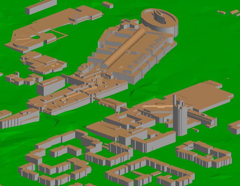
8 Cadastral Mapping Issues - Accuracy Modeling the real world 2D/3D graphic representation 2D interpretation vs. 3D realism Geometry is created in 3-D context for infrastructure mapping why not for cadastral mapping? Engineering assets of all types populate and extend this geometry - mapping and engineering disciplines become one


9

10 Matti Arponen, GIS Manager,
11
12
13 Cadastral Mapping Issues Data Creation and Maintenance Data collection techniques» Traditional surveys and photogrammetric data collection» LIDAR and other sensed data collection» Digital video capture» 3D model creation of cadastre and associated infrastructure
14
15
16
17
18

19

20 Cadastral Mapping Issues Data Creation and Maintenance Fast, accurate, easy editing» Speed» Efficiency» Flexibility of workflows


21 Cadastral Mapping Issues Data Management Types of Data» Vector maps» Digital CAD drawings» Scanned drawings» Images» Documents» Videos» Website links
22 Cadastral Mapping Issues Data Management Storage where does data live properly?» Graphics, geometry, designs typically file-based storage» Attributes, topology, relationships generally databases Think of the nature of the data
23 Cadastral Mapping Issues Data Management Proprietary Data Management System» Efficient data handling of controlled data types» Not flexible in handling non GIS data Enterprise Data Store» Excellent for large amounts of homogeneous or attribute data» Not ideal for design documents and design workflows Federated Data Management» Keep data in native format» Powerful hybrid approach to real corporate-wide information management
24


25 Cadastral Mapping Issues Federated Data Management Adding the spatial component» Organize and access spatial data spatially Integrating engineering, design, parcel maps, GIS analysis results and associated non-spatial information
26 Cadastral Mapping Issues Publishing and communications methods Fast, accurate hard-copy capability» Need flexible, customizable output techniques Web-based display and printing» Fast to set up; Easy to do; Meaningful results Digital transmission , mobile, PDF, etc.» Internal and External communications Adobe Acrobat 7.0 Document JPEG Image Adobe Acrobat 7.0 Document
27
28 Cadastral Mapping Issues Publishing and communications methods Fast, accurate hard-copy capability» Need flexible, customizable output techniques Web-based display and printing» Fast to set up; Easy to do; Meaningful results Digital transmission , mobile, PDF, etc.» Internal and External communications Adobe Acrobat 7.0 Document JPEG Image Adobe Acrobat 7.0 Document

29 Available Technology Desktop applications Traditional GIS tools» Strong on analysis» Weak on data entry and maintenance Engineering design applications» Designed for engineers, not for mappers» Offer required precision but tools are cumbersome Hybrid Engineering / Cadastral Mapping Solutions» Combine the best of both worlds» Allow cadastral mappers to model real life
30 Available Technology Server-based information management Document management systems» Traditional information management Database storage and retrieval» Often proprietary middleware - tied to traditional GIS models Geospatial information management» Hybrid Solution Spatial interface to information management» Federated data management, not data normalization


31 Web-based information systems Available Technology Traditionally for viewing only Expanding into data update, QC activities, map creation Digital publishing

32 Future of Land Management 3D cadastre Combination of traditional cadastre and real-world modeling and engineering applications Leveraging the power of engineering applications Expanding the definition of cadastre More than parcels and ownership records E-government sites as data communication mechanisms Virtual reality
33 Conclusions Engineering accuracy is required for cadastral applications Definition of cadastre will expand to include modeling of real world infrastructure 3D is required Federated information management is the only way to join multiple disciplines
Introduction to Geodatabase and Spatial Management in ArcGIS. Craig Gillgrass Esri
 Introduction to Geodatabase and Spatial Management in ArcGIS Craig Gillgrass Esri Session Path The Geodatabase - What is it? - Why use it? - What types are there? - What can I do with it? Query Layers
2011 Bentley Systems, Incorporated. Bentley Descartes V8i Advancing Information Modeling For Intelligent Infrastructure
 Bentley Descartes V8i Advancing Information Modeling For Intelligent Infrastructure Agenda Why would you need Bentley Descartes? What is Bentley Descartes? Advanced Point Cloud Workflows Advanced Terrain
GEOSPATIAL ENGINEERING COMPETENCIES. Geographic Information Science
 GEOSPATIAL ENGINEERING COMPETENCIES Geographic Information Science The character and structure of spatial information, its methods of capture, organisation, classification, qualification, analysis, management,
Standardized Data Production Strategies Across Your Enterprise
 Federal GIS Conference February 9 10, 2015 Washington, DC Standardized Data Production Strategies Across Your Enterprise Amber Bethell Sherry Fagin Authoritative content producers Knowledge Workers Executive
The cadastral data and standards based on XML in Poland
 The cadastral data and standards based on XML in Poland Jarosław Bydłosz, Piotr Parzych AGH University of Science and Technology Cracow, Poland 1 XML XML Extensible Markup Language Extensible Markup Language
The Existing Legal Cadastre in Israel Introduced in 1928 Based on Torrens principles (Registration of Title) Two-Dimensional Surface properties Owners
 Two-Dimensional Surface properties Owners") 3D Cadastre GIS Geometry, Topology and other Technical Considerations Presented by Moshe Benhamu & Shay Cherutil Written by: Nurit Peres & Moshe Benhamu FIG Working Week, May 07, 2009, Eilat Agenda Introduction
3D Cadastre GIS Geometry, Topology and other Technical Considerations Presented by Moshe Benhamu & Shay Cherutil Written by: Nurit Peres & Moshe Benhamu FIG Working Week, May 07, 2009, Eilat Agenda Introduction
Oracle Spatial Technologies: An Update. Xavier Lopez Director, Spatial Technologies Oracle Corporation
 Oracle Spatial Technologies: An Update Xavier Lopez Director, Spatial Technologies Oracle Corporation Overview Oracle Approach to Market Specialist v. Generalist Solutions New Developments: Oracle Database
Challenges that can be overcome with the aid of ESA GIM Click to edit Master text styles
 Click to edit Agenda Master By: Egyptian Survey Authority Geographic Information Management System Kholoud Saad Salama Egypt (ESA GIM) 1 About Egyptian Survey Authority Third ESA GIM level Business Requirements
Modernizing California State Highway Right of Way Records with GIS. Caltrans District 4 Oakland, CA
 Modernizing California State Highway Right of Way Records with GIS Caltrans District 4 Oakland, CA About Us Kirsten Lawrence (GISP), Senior Geospatial Analyst on staff augmentation contract with Caltrans
IMAGERY FOR ARCGIS. Manage and Understand Your Imagery. Credit: Image courtesy of DigitalGlobe
 IMAGERY FOR ARCGIS Manage and Understand Your Imagery Credit: Image courtesy of DigitalGlobe 2 ARCGIS IS AN IMAGERY PLATFORM Empowering you to make informed decisions from imagery and remotely sensed data
Oracle 10g GeoSpatial Technologies. Eve Kleiman Asia/Pacific Spatial Product Manager Oracle Corporation
 Oracle 10g GeoSpatial Technologies Eve Kleiman Asia/Pacific Spatial Product Manager Oracle Corporation Eve.Kleiman@oracle.com Agenda Market and Technology Trends Oracle GeoSpatial Technology Stack What
3D in the ArcGIS Platform. Chris Andrews
 3D in the ArcGIS Platform Chris Andrews Geospatial 3D is already all around us 3D is expanding the GIS community s opportunity to provide value 3D City & Infrastructure Models Generated 3D features Photogrammetrc
Bringing Singapore to life in 3D
 Bringing Singapore to life in 3D Dr Victor Khoo, Deputy Director Singapore Land Authority Bringing Singapore to life in 3D ESRI Singapore UC 2016 Dr. Victor Khoo Singapore Land Authority SLA 2016 RESTRICTED
Bridging the gap between CAD and GIS for Cadastral Mapping
 Bridging the gap between CAD and GIS for Cadastral Mapping CCMA 2008 Annual Conference - Sacramento Colin Hobson Munsys, Inc Sample Customers North America Overview Munsys provides an integrated family
Municipal Parcel Mapping Workshop
 Municipal Parcel Mapping Workshop Presented to: Ontario Municipalities Presented by: Dave Gariepy, Director of Platform Content Dave Horwood, Land Information Systems Architect Sarah Sibbett, Senior Parcel
Facilities Management Data Input, Editing and Management. Adrien Litton
 Facilities Management Data Input, Editing and Management Adrien Litton Overview What is FM in GIS? Data input Data editing Data management Supporting the Real Property Life-Cycle GIS Integrates the Facility
Quality Assurance and Quality Control Procedures for Survey-Grade Mobile Mapping Systems
 Quality Assurance and Quality Control Procedures for Survey-Grade Mobile Mapping Systems Latin America Geospatial Forum November, 2015 Agenda 1. Who is Teledyne Optech 2. The Lynx Mobile Mapper 3. Mobile
Copyright 2012, Oracle and/or its affiliates. All rights reserved.
 1 Real Life Applications of Location Analytics Dan Geringer, Senior Software Development Manager, Oracle Jayant Sharma, Director Prod Mgmt, Oracle 2 The following is intended to outline our general product
InfraGML. Linking pin between Geo and BIM. 4 november 2014
 InfraGML Linking pin between Geo and BIM Marcel Reuvers (Geonovum) 4 november 2014 GIS Roads DTM GIS scope: Scale 1:500 1:25:000 Coordinates system CRS Features Topology networks Themes Cables and pipes
An Introduction to GIS for developers
 An Introduction to GIS for developers Part 4: GIS Sharing Canserina Kurnia & Tom Shippee Agenda Web GIS ArcGIS Online Cloud-based ArcGIS Server ArcGIS Server on-premises ArcGIS a complete platform discover,
ArcGIS Data Reviewer: Ensuring Accurate and Complete Data to Meet Your Mission. John Grammer Kevin Pusey
 ArcGIS Data Reviewer: Ensuring Accurate and Complete Data to Meet Your Mission John Grammer Kevin Pusey Workshop agenda Defining data quality What is ArcGIS Data Reviewer? Automated review Semi-automated
FDO Data Access Technology at a Glance
 Autodesk Geospatial FDO Data Access Technology at a Glance Work seamlessly with your geospatial data whatever the format 1 The Challenge The growing need for openness and interoperability between traditional
Research Collection. Approaches to data modelling in GIS. Conference Paper. ETH Library. Author(s): Mitášová, Irena; Niederöst, Jana; Hájek, Milan
: Mitášová, Irena; Niederöst, Jana; Hájek, Milan") Research Collection Conference Paper Approaches to data modelling in GIS Author(s): Mitášová, Irena; Niederöst, Jana; Hájek, Milan Publication Date: 1996 Permanent Link: https://doi.org/10.3929/ethz-a-004331855
Research Collection Conference Paper Approaches to data modelling in GIS Author(s): Mitášová, Irena; Niederöst, Jana; Hájek, Milan Publication Date: 1996 Permanent Link: https://doi.org/10.3929/ethz-a-004331855
Smallworld Core Spatial Technology 4 Spatial data is more than maps tracking the topology of complex network models
 Smallworld Core Spatial Technology 4 Spatial data is more than maps tracking the topology of complex network models 2004 General Electric Company. All Rights Reserved GER-4230 (10/04) Abstract Spatial
ArcMap - EXPLORING THE DATABASE Part I. SPATIAL DATA FORMATS Part II
 Week 5 ArcMap - EXPLORING THE DATABASE Part I SPATIAL DATA FORMATS Part II topics of the week Exploring the Database More on the Table of Contents Exploration tools Identify, Find, Measure, Map tips, Hyperlink,
The AAA Model as Contribution to the Standardisation of the Geoinformation Systems in Germany
 The AAA Model as Contribution to the Standardisation of the Geoinformation Systems in Germany Markus SEIFERT, Germany Key words: ISO, CEN, OGC, AdV, Spatial Data Infrastructure SUMMARY Germany is a classic
Spatial Data Management
 Spatial Data Management [R&G] Chapter 28 CS432 1 Types of Spatial Data Point Data Points in a multidimensional space E.g., Raster data such as satellite imagery, where each pixel stores a measured value
GISCI GEOSPATIAL CORE TECHNICAL KNOWLEDGE EXAM CANDIDATE MANUAL AUGUST 2017
 GISCI GEOSPATIAL CORE TECHNICAL KNOWLEDGE EXAM CANDIDATE MANUAL AUGUST 2017 This document provides information about the GISCI Geospatial Core Technical Knowledge Exam, now a requirement for GISCI GISP
IMAGINE Objective. The Future of Feature Extraction, Update & Change Mapping
 IMAGINE ive The Future of Feature Extraction, Update & Change Mapping IMAGINE ive provides object based multi-scale image classification and feature extraction capabilities to reliably build and maintain
THE GEOMEDIA ARCHITECTURE ADVANTAGE
 THE GEOMEDIA ARCHITECTURE ADVANTAGE White Paper April 04, 2014 Contents 1. Introduction... 3 2. GeoMedia Overview... 3 3. The GeoMedia Architecture Advantage... 3 3.1 GeoMedia Data Servers... 4 3.2 Geographic
Spatial Data Management
 Spatial Data Management Chapter 28 Database management Systems, 3ed, R. Ramakrishnan and J. Gehrke 1 Types of Spatial Data Point Data Points in a multidimensional space E.g., Raster data such as satellite
Egyptian Survey Authority Geographic Information Management System (ESA GIM)
") Egyptian Survey Authority Geographic Information Management System (ESA GIM) Sohail El ABD and Kholoud SAAD, Egypt Key words: GIS, theme, etc. SUMMARY ESA can be regarded as the backbone for supplying
Egyptian Survey Authority Geographic Information Management System (ESA GIM) Sohail El ABD and Kholoud SAAD, Egypt Key words: GIS, theme, etc. SUMMARY ESA can be regarded as the backbone for supplying
Mike Horsfall Technical Manager GeoSpatial Sales
 An Introduction to Bentley Utilities Designer Mike Horsfall Technical Manager GeoSpatial Sales What is Bentley Utilities Designer? Bentley Utilities Designer is: A multi-utilities desktop GIS Built on
Principles of Data Management. Lecture #14 (Spatial Data Management)
") Principles of Data Management Lecture #14 (Spatial Data Management) Instructor: Mike Carey mjcarey@ics.uci.edu Database Management Systems 3ed, R. Ramakrishnan and J. Gehrke 1 Today s Notable News v Project
Principles of Data Management Lecture #14 (Spatial Data Management) Instructor: Mike Carey mjcarey@ics.uci.edu Database Management Systems 3ed, R. Ramakrishnan and J. Gehrke 1 Today s Notable News v Project
Surface Shape Regions as Manifestations of a Socio-economic Phenomenon
 Surface Shape Regions as Manifestations of a Socio-economic Phenomenon a solution to the choropleth mapping problem by John (Jack) Sirles Massey a thesis submitted for the degree of Master of Science in
Using Mobile LiDAR To Efficiently Collect Roadway Asset and Condition Data. Pierre-Paul Grondin, B.Sc. Surveying
 Using Mobile LiDAR To Efficiently Collect Roadway Asset and Condition Data Pierre-Paul Grondin, B.Sc. Surveying LIDAR (Light Detection and Ranging) The prevalent method to determine distance to an object
Advanced Parcel Editing. Amy Andis Tim Hodson
 Advanced Parcel Editing Amy Andis Tim Hodson Overview What to expect in this technical workshop Review of the Parcel Fabric Data Model Advanced Tips and tricks for Parcel entry Assessing Quality of Parcel
Slide 1. Bentley Descartes V8i. Presented by: Inga Morozoff, Bentley
 Slide 1 Bentley Descartes V8i Presented by: Inga Morozoff, Bentley Slide 2 Agenda What is Bentley Descartes? Where is it used? Features Benefits Live demo Questions and Answers 2 WWW.BENTLEY.COM Slide
Lessons Learned from Implementing an Enterprise GIS solution for Cross-Country Pipeline Routing
 Lessons Learned from Implementing an Enterprise GIS solution for Cross-Country Pipeline Routing Jackie Smith, Williams Wetherbee Dorshow, Earth Analytic, Inc April 27, 2016 2013 The Williams Companies,
A Spatial Decision Support System Design for Land Consolidation Projects
 A Spatial Decision Support System Design for Land Consolidation Projects Tayfun CAY, Mevlut UYAN Selcuk University, Konya (TURKEY) 1 1. INTRODUCTION Land consolidation can be described as rearranging and
California GIS Enterprise Strategy
 California GIS Enterprise Strategy David Harris Geospatial Information Officer California Natural Resources Agency December 3, 2009 Outline OCIO / GIO Background California GIS Task Force Report California
Enterprise GIS for Managing Reservation Land
 Enterprise GIS for Managing Reservation Land Beckie Howell GIS Manager Agua Caliente Band of Cahuilla Indians ESRI UC 2014 Tribal Indigenous GIS Track Empowering Tribal Governments with Enterprise GIS
technical notes trimble realworks software
 technical notes trimble realworks software A POWERFUL 3D LASER SCANNING OFFICE SOFTWARE SUITE Designed for today s multifaceted scanning professional, Trimble RealWorks is a powerful office software that
Maps as Numbers. Maps as Numbers. Chapter 3: Maps as Numbers 14SND Getting Started with GIS Chapter 3
 Maps as Numbers Getting Started with GIS Chapter 3 Chapter 3: Maps as Numbers 3.1 Representing Maps as Numbers 3.2 Structuring Attributes 3.3 Structuring Maps 3.4 Why Topology Matters 3.5 Formats for GIS
Port Asset Management with 3D Visualization. Dr. Hussein Harahsheh Idom Consulting, UAE
 Port Asset Management with 3D Visualization Dr. Hussein Harahsheh Idom Consulting, UAE Port of Algeciras 1 3 4 Port of Algeciras The Port Authority of the Algeciras Bay (APBA) is engaged in a global improvement
2011 Bentley Systems, Incorporated. Bentley Descartes V8i (SELECTseries 3) Advancing Information Modeling For Intelligent Infrastructure
 Advancing Information Modeling For Intelligent Infrastructure") Bentley Descartes V8i (SELECTseries 3) Advancing Information Modeling For Intelligent Infrastructure What is Bentley Descartes? Image Processing Raster Geo-Referencing Advanced raster transformation (warping,
Bentley Descartes V8i (SELECTseries 3) Advancing Information Modeling For Intelligent Infrastructure What is Bentley Descartes? Image Processing Raster Geo-Referencing Advanced raster transformation (warping,
ArcGIS 9.2 Works as a Complete System
 ArcGIS 9.2 Works as a Complete System A New Way to Manage and Disseminate Geographic Knowledge Author/Serve/Use Maps Data Models Globes Metadata Use Desktop Explorer Web Map Viewer Mobile Open APIs Enterprise
Trimble Realworks Software
 TECHNICAL NOTES Trimble Realworks Software A Powerful 3D Laser Scanning Office Software Suite DESIGNED FOR TODAY S MULTIFACETED SCANNING PROFESSIONAL, TRIMBLE REALWORKS IS A POWERFUL OFFICE SOFTWARE THAT
Editing Versioned Geodatabases : An Introduction
 Esri International User Conference San Diego, California Technical Workshops July 24, 2012 Editing Versioned Geodatabases : An Introduction Cheryl Cleghorn Shawn Thorne Assumptions: Basic knowledge of
Planning Enterprise Geodatabase Solutions
 Esri Middle East and Africa User Conference December 10 12 Abu Dhabi, UAE Planning Enterprise Geodatabase Solutions Pete Fitts Agenda Overview Database Design Data Maintenance Infrastructure Design and
Cooperative collaboration between Municipalities using public GIS
 Cooperative collaboration between Municipalities using public GIS Prof. M. AbdelAziz, Professor, Department of Urban Planning, Faculty of Engineering, Al-Azhar University, Cairo, Egypt, (email: m_azizh@yahoo.com).
Bentley Descartes and what s new in Descartes V8i (SELECTseries 3) What is Bentley Descartes? 2011 Bentley Systems, Incorporated
 What is Bentley Descartes? 2011 Bentley Systems, Incorporated") Bentley Descartes and what s new in Descartes V8i (SELECTseries 3) Tom Stogdill Bentley Systems, Inc. What is Bentley Descartes? Image Processing Raster Geo-Referencing Advanced raster transformation (warping,
Bentley Descartes and what s new in Descartes V8i (SELECTseries 3) Tom Stogdill Bentley Systems, Inc. What is Bentley Descartes? Image Processing Raster Geo-Referencing Advanced raster transformation (warping,
Accessing and Administering your Enterprise Geodatabase through SQL and Python
 Accessing and Administering your Enterprise Geodatabase through SQL and Python Brent Pierce @brent_pierce Russell Brennan @russellbrennan hashtag: #sqlpy Assumptions Basic knowledge of SQL, Python and
Working with the ArcGIS Viewer for Flex Application Builder
 Working with the ArcGIS Viewer for Flex Application Builder Esri Canada User Conference St. John s November 15, 2012 Presented By: Greg Yetman gyetman@esri.ca Agenda This seminar is designed to help you
Paul Hardy. We Live in a Rapidly Changing World. Mobile Mapping: Collect, Manage, Produce, Share. MMT Krakow, Many Forces Are Converging
 Mobile Mapping: Collect, Manage, Produce, Share MMT Krakow, 2011 Paul Hardy We Live in a Rapidly Changing World Increasingly Driven by Population Growth & Human Action Impacting Environment Society Economy
Advances in GIS help create Smarter Communities
 Advances in GIS help create Smarter Communities POP(ovich) Quiz Who is a Desktop User? Who is an ArcGIS Online User? Who is a ArcGIS Server Admin? Who is a Programmer? Who works with or for a government
Tips for a Good Meshing Experience
 Tips for a Good Meshing Experience Meshes are very powerful and flexible for modeling 2D overland flows in a complex urban environment. However, complex geometries can be frustrating for many modelers
Chapter 3: Maps as Numbers
 Chapter 3: Maps as Numbers 3. Representing Maps as Numbers 3.2 Structuring Attributes 3.3 Structuring Maps 3.4 Why Topology Matters 3.5 Formats for GIS Data 3.6 Exchanging Data David Tenenbaum EEOS 265
Autodesk Utility Design and Your GIS
 UT4523-P Autodesk Utility Design and Your GIS Prashant Srivastav Quality Assurance Lead, Utilities Co Speakers: Jeff Saunders, Carsten Hess The Power Track Utility Design Power Track at a glance... and
GOVERNMENT GAZETTE REPUBLIC OF NAMIBIA
 GOVERNMENT GAZETTE OF THE REPUBLIC OF NAMIBIA N$7.20 WINDHOEK - 7 October 2016 No. 6145 CONTENTS Page GENERAL NOTICE No. 406 Namibia Statistics Agency: Data quality standard for the purchase, capture,
PKI is Alive and Well: The Symantec Managed PKI Service
 PKI is Alive and Well: The Symantec Managed PKI Service Marty Jost Product Marketing, User Authentication Lance Handorf Technical Enablement, PKI Solutions 1 Agenda 1 2 3 PKI Background: Problems and Solutions
GIS Basics for Urban Studies
 GIS Basics for Urban Studies Date: March 21, 2018 Contacts: Mehdi Aminipouri, Graduate Peer GIS Faciliator, SFU Library (maminipo@sfu.ca) Keshav Mukunda, GIS & Map Librarian Librarian for Geography (kmukunda@sfu.ca)
Feature Enhancements by Release
 Autodesk Map Feature Enhancements by Release This document highlights the feature enhancements that have occurred with each release of Autodesk Map software from Release 4 (2000i) through the current 2004
CPSC 695. Data Quality Issues M. L. Gavrilova
 CPSC 695 Data Quality Issues M. L. Gavrilova 1 Decisions Decisions 2 Topics Data quality issues Factors affecting data quality Types of GIS errors Methods to deal with errors Estimating degree of errors
THE CONCEPT OF. esilience MULTIDISCIPLINARY CENTER FOR EARTHQUAKE ENGINEERING RESEARCH
 THE CONCEPT OF 4 esilience 4 The Four Fundamental Properties of Resilience r r obustness esourcefulness r r edundancy apidity Enhancing resilience against multiple hazards using innovative spatial data
JANUARY 2017 WATER S END. Mobile Mapping. Station to Station. Decided Guidance Indoor application. Implementing BIM. A fixed boundary R E YEARS
 JANUARY 2017 WATER S END Mobile Mapping Station to Station Decided Guidance Indoor application Implementing BIM A fixed boundary R LEB ATING E C 30 YEARS Indoor Mobile Mapping A unique approach to interior
Integrating ArcGIS desktop in data interoperability environments with heterogeneous GIS clients
 Data-Interoperability based on Common Databases Integrating ArcGIS desktop in data interoperability environments with heterogeneous GIS clients M.Sc Abdurasyid Moestofa / Prof. Rainer Kettemann Stuttgart
DecisionSpace Seismic Interpretation Software
 DATA SHEET DecisionSpace Seismic Interpretation Software DecisionSpace Geosciences Key Features Advanced auto-tracking tools Dynamic domain conversion to interpret in time, depth, or both Automated mapping,
FIG Working Week 2015
 Geodesy / National Survey Session TS05D GIS, 3D Data and Cadastre Towards a Distortion Free National Spatial Data Infrastructure SDI in Switzerland: Approach, Developed Tools and Internet for the Change
Review of Cartographic Data Types and Data Models
 Review of Cartographic Data Types and Data Models GIS Data Models Raster Versus Vector in GIS Analysis Fundamental element used to represent spatial features: Raster: pixel or grid cell. Vector: x,y coordinate
GISP: The Road to and Through an Exam. Presented By: Bill Hodge, GISP Executive Director GISCI June 7, 2017 GeoEd 17
 GISP: The Road to and Through an Exam Presented By: Bill Hodge, GISP Executive Director GISCI June 7, 2017 GeoEd 17 GISP An Updated Perspective Certification GISP Certification History GISP Current Process
PI Integrator for Esri ArcGIS: A Journey Through Time and Space
 PI Integrator for Esri ArcGIS: A Journey Through Time and Space Presented by Vadim Fedorov, Sr. Systems Engineer Elizabeth Ammarell, Product Manager The Past: Where We Started 2 Two companies, one vision
Enterprise Architecture Deployment Options. Mark Causley Sandy Milliken Sue Martin
 Enterprise Architecture Deployment Options Mark Causley Sandy Milliken Sue Martin GIS is Being Implemented in Many Settings Organization Business to Business Department Workgroup GIS is Moving to the Enterprise
Singapore. Mr Soh Kheng Peng. Singapore Land Authority
 Country Report 2006 (Based on the PCGIAP-Data Integration Template 2006) Singapore Country/state: Name of contact person: Affiliation, Organization: Function, Position: Address: Email address: Tel, Fax
Questions and Answers
 Autodesk AutoCAD Raster Design 2011 Questions and Answers AutoCAD Raster Design 2011 Questions and Answers Make the most of rasterized scanned drawings, maps, aerial photos, satellite imagery, and digital
Land Administration and Management: Big Data, Fast Data, Semantics, Graph Databases, Security, Collaboration, Open Source, Shareable Information
 Land Administration and Management: Big Data, Fast Data, Semantics, Graph Databases, Security, Collaboration, Open Source, Shareable Information Platform Steven Hagan, Vice President, Engineering 1 Copyright
Transformative characteristics and research agenda for the SDI-SKI step change:
 Transformative characteristics and research agenda for the SDI-SKI step change: A Cadastral Case Study Dr Lesley Arnold Research Fellow, Curtin University, CRCSI Director Geospatial Frameworks World Bank
Transformative characteristics and research agenda for the SDI-SKI step change: A Cadastral Case Study
 Transformative characteristics and research agenda for the SDI-SKI step change: A Cadastral Case Study Dr Lesley Arnold Research Fellow, Curtin University, CRCSI Director Geospatial Frameworks World Bank
UAV s in Surveying: Integration/processes/deliverables A-Z. 3Dsurvey.si
 UAV s in Surveying: Integration/processes/deliverables A-Z Info@eGPS.net TODAY S PROGRAM Introduction to photogrammetry and 3Dsurvey Theoretical facts about the technology and basics of 3dsurvey Introduction
Geog 469 GIS Workshop. System Requirements - Data
 Geog 469 GIS Workshop System Requirements - Data Outline 1. What are some principles of project management? 2. What are some fundamental issues associated with system requirements? 3. What are some issues
Lecture 6: GIS Spatial Analysis. GE 118: INTRODUCTION TO GIS Engr. Meriam M. Santillan Caraga State University
 Lecture 6: GIS Spatial Analysis GE 118: INTRODUCTION TO GIS Engr. Meriam M. Santillan Caraga State University 1 Spatial Data It can be most simply defined as information that describes the distribution
CHAPTER 2 GEOREFERENCING AND SHAPEFILE CREATION
 CHAPTER 2 GEOREFERENCING AND SHAPEFILE CREATION Georeferencing is the process of assigning real-world coordinates to each pixel of the raster. These coordinates are obtained by doing field surveys - collecting
The GIS Spatial Data Model
 The GIS Spatial Data Model Introduction: Spatial data are what drive a GIS. Every piece of functionality that makes a GIS separate from another analytical environment is rooted in the spatially explicit
The Oracle Enterprise Geodatabase (EGDB) Charlie Crocker Farallon Geographics, Inc.
 Charlie Crocker Farallon Geographics, Inc.") The Oracle Enterprise Geodatabase (EGDB) Charlie Crocker Farallon Geographics, Inc. www.fargeo.com Norcal URISA Chapter Meeting 2/9/2005 Todays Goals Enterprise geodatabase defined Roles Oracle can play
The Oracle Enterprise Geodatabase (EGDB) Charlie Crocker Farallon Geographics, Inc. www.fargeo.com Norcal URISA Chapter Meeting 2/9/2005 Todays Goals Enterprise geodatabase defined Roles Oracle can play
A FRAMEWORK FOR MAINTAINING A MULTI-USER GEODATABASE: AN EMPIRICAL EXAMPLE. Muniru Ayotunde Owoola PhD
 A FRAMEWORK FOR MAINTAINING A MULTI-USER GEODATABASE: AN EMPIRICAL EXAMPLE Muniru Ayotunde Owoola PhD GIS Manager, Maltais Geomatics Inc. 70 0 Avenue, NW Edmonton, AB TP L Canada tunde@maltaisgeomatics.com
Geometric Modeling. Introduction
 Geometric Modeling Introduction Geometric modeling is as important to CAD as governing equilibrium equations to classical engineering fields as mechanics and thermal fluids. intelligent decision on the
Assimilating GIS-Based Voter Districting Processes in Maricopa County, Arizona
 Assimilating GIS-Based Voter Districting Processes in Maricopa County, Arizona Tim Johnson Geographic Information Systems Manager Maricopa County Recorder/Elections Department Abstract Accurate district
Leveraging OGC Services in ArcGIS Server. Satish Sankaran, Esri Yingqi Tang, Esri
 Leveraging OGC Services in ArcGIS Server Satish Sankaran, Esri Yingqi Tang, Esri GIS Creating and Managing Geo Information Products - Proprietary - Open Specifications - Standards Dissemination of Geo
SERVO - ACES Abstract
 1 of 6 12/27/2004 2:33 PM 2 of 6 12/27/2004 2:33 PM Implementing GIS Grid Services for the International Solid Earth Research Virtual Observatory Galip Aydin (1), Marlon Pierce (1), Geoffrey Fox (1), Mehmet
EDIN Frequently Asked Questions
 EDIN Frequently Asked Questions January 2017 Author: M Diaz Copyright 2017 IHS Markit Ltd Login / Access 3 User Stats 4 Software Requirements 5 Data Integrity 6 Browsers 7 Settings 8 Data Content 9 Map
Oracle Spatial 10g: Platform for Enterprise Geospatial Solutions
 11/30/2005-8:00 am - 9:30 am Room:Macaw 1/2 (Swan) Walt Disney World Swan and Dolphin Resort Orlando, Florida Oracle Spatial 10g: Platform for Enterprise Geospatial Solutions Xavier Lopez - Oracle USA,
QGIS Workshop Su Zhang and Laura Gleasner 11/15/2018. QGIS Workshop
 1. Introduction to QGIS QGIS Workshop QGIS is a free and open source Geographic Information System (GIS). QGIS can help users create, edit, visualize, analyze, and publish geospatial information on various
Digital Softcopy Photogrammetry
 LLP Erasmus IP EPOCHE 2013 Thassos Island, Greece, 2-16 June 2013 Digital Softcopy Photogrammetry Prof. Levente DIMEN The 1 Decembrie 1918 University of Alba Iulia, Romania GENERAL CONTEXT In the last
DATA QUALITY ELEMENTS FOR BIM APPLIED TO HERITAGE MONUMENTS
 DATA QUALITY ELEMENTS FOR BIM APPLIED TO HERITAGE MONUMENTS Íñigo ARIZA-LÓPEZ 1, Francisco Javier ARIZA-LÓPEZ 2, Juan Francisco REINOSO-GORDO 3, Antonio GÓMEZ-BLANCO 4, Concepción RODRÍGUEZ-MORENO 5, Carlos
Introducing ArcScan for ArcGIS
 Introducing ArcScan for ArcGIS An ESRI White Paper August 2003 ESRI 380 New York St., Redlands, CA 92373-8100, USA TEL 909-793-2853 FAX 909-793-5953 E-MAIL info@esri.com WEB www.esri.com Copyright 2003
Re: Developing Requirements for Mobile LiDAR Data (#1015)
") TM Tech Notes Certainty 3D April 10, 2012 To: General Release From: Ted Knaak Certainty 3D, Inc. Re: Developing Requirements for Mobile LiDAR Data (#1015) Introduction Recent discussions within the industry
TM Tech Notes Certainty 3D April 10, 2012 To: General Release From: Ted Knaak Certainty 3D, Inc. Re: Developing Requirements for Mobile LiDAR Data (#1015) Introduction Recent discussions within the industry
Bentley Systems Army Training Program Focuses on CAD GIS Integration
 Bentley Systems Army Training Program Focuses on CAD GIS Integration Tom Brown, Army Account Manager, Bentley Systems, Inc. Installations face serious challenges managing, analyzing and publishing geospatial
Marushka Server. Product Specification
 Introductory Information Product Marushka Server represents a new generation of tools (devices) for publication and use of GIS data in the Internet and intranet. It is built on component technology in.net
May 2012 Oracle Spatial User Conference
 1 May 2012 Oracle Spatial User Conference May 23, 2012 Ronald Reagan Building and International Trade Center Washington, DC USA Andrew Howles & Jo Shannon IS Principal Architect General Manager, Operations
Providing Interoperability Using the Open GeoServices REST Specification
 2013 Esri International User Conference July 8 12, 2013 San Diego, California Technical Workshop Providing Interoperability Using the Open GeoServices REST Specification Satish Sankaran Kevin Sigwart What