Online intercomparison of models and observations using OGC and community standards
|
|
|
- Lee Terry
- 5 years ago
- Views:
Transcription

1 Online intercomparison of models and observations using OGC and community standards Alastair Gemmell * Jon Blower Keith Haines Adit Santokhee Reading e-science e Centre, Environmental Systems Science Centre, University of Reading, UK Plus lots of colleagues on ECOOP project OGC/GIS/Met meeting, Toulouse, November 2009


2 Reading e-science e Centre Based in Environmental Systems Science Centre, University of Reading, UK Goal is to apply novel IT techniques to scientific research We are scientists and software engineers, not data providers We work with many kinds of data: model, in situ, remote sensing In many scientific areas (oceanography, meteorology, climate science, hydrology...) OpenGIS can help us to bring these datasets together
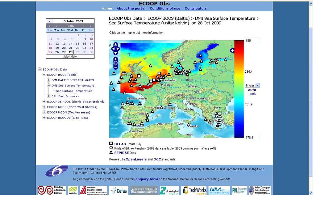
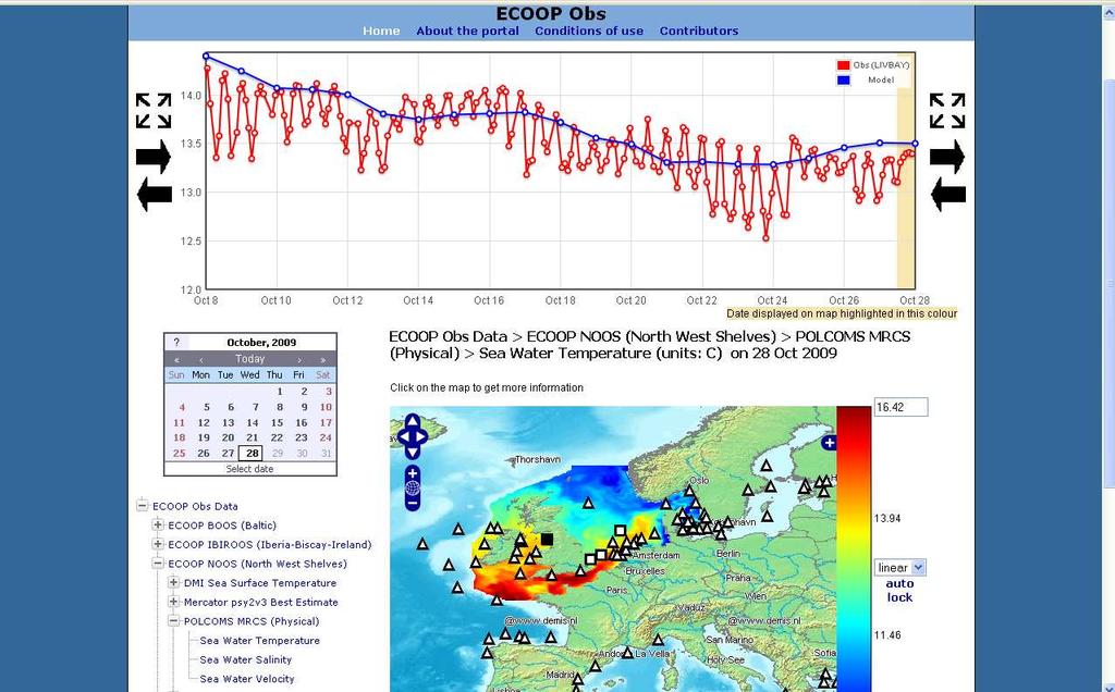
3 ECOOP Ecosystem Portal ECOOP: European COastal Sea Operational observing and forecasting system. Aim is to compare in-situ observations and model analyses/forecasts as a technology demo for predicting harmful algal blooms in the North Sea. Intercomparison gives users more confidence in bloom predictions if past observed and model data agree relatively well Physical data (temperature, salinity and velocity) Biological data (biomass, nitrate and silicate concentrations) Data distributed among the partners
4
5
6

7 Comparing / co-plotting datasets can catch errors! This looks like a suspiciously large and constant difference between obs and model
 ESSC ncwms web app. ESSC Web Portal ESSC ECOOP Obs web app. ESSC Ferrybox (NetCDF)")
8 ECOOP Ecosystem Portal architecture REMOTE PML POLCOMS-ERSEM MRCS model (Biological, CF-NetCDF) CEFAS SmartBuoys SMHI SEPRISE In-situ data ASCII PML THREDDS Server HR Wallingford WFS OPeNDAP CSML LOCAL ESSC POLCOMS MRCS model (Physical, NetCDF) ESSC ncwms web app. ESSC Web Portal ESSC ECOOP Obs web app. ESSC Ferrybox (NetCDF)

 (vertical profile at a")
 SwathFeature")
")
9 Representing data as CSML PointSeriesFeature (timeseries at a point) ProfileFeature Features (selected) (vertical profile at a point) GridSeriesFeature (series of multidimensional grids) SwathFeature (single satellite sweep) SectionFeature (vertical section) Feature Types are classified by their geometry
10 How it works Model data accessed through OPeNDAP and ncwms pseudo-observations extracted through WMS GetFeatureInfo In situ observations accessed through WFS and direct NetCDF file access GeoServer, serving CSML documents Custom dynamic web interface based on OpenLayers
11 How would we like to improve Harmonize the data access layer (right) GetFeatureInfo should return CSML Bring in other data sources Allow data download Output CSML data model in various formats, inc. NetCDF, XML, CSV Would SOS be more suitable than WFS? this?
12 Challenges in using CSML for Multiplicities data exchange Inheritance from GML gives large number of encoding options Many ways of encoding soft typed quantities like units, phenomena, coordinate systems So we need a cookbook of recommended best practice to reduce the options to something manageable A profile of a profile essentially GeoSciML did this too
13 What value do we get from OGC for this kind of app? The input of a much wider community More robust domain modelling Software reuse Mainly for semantically light services WMS and simple-feature WFS Other domains will be familiar with terms and technology A warm fuzzy feeling Sometimes, anyway ;-);
14 Where is the OGC approach less helpful? WFS 1.0 doesn t t support feature subsetting We invented a syntax for timeseries subsetting Serving gridded (model) data WCS currently adds very little value above CF-OPeNDAP in practice for this app Not much real interoperability with third parties in terms of data Interop of geospatial component much better All OGC services need profiling for our use... But what does that mean for other communities with different profiles?
15 Suggestion for maximizing value of WFS approach First point of entry should be a simple-feature WFS Serves observation locations only Serves observation locations Plus simple text attributes (e.g. Instrument type) Accessible by most OpenGIS clients and communities Allows reuse of lots of existing tools Clicking on obs location gives fully-specified complex feature In highly precise formats for special clients, e.g. CSML In less precise formats for general audience, e.g. HTML, CSV Options to subset the feature through WFS 2.0 Requires links between services Looks more like the Web
16 Conclusions and suggestions Combination of met-ocean community and OGC standards used to support online data intercomparison CSML data model is a very practical abstraction (although we still need to specialize it further to be implementable) Convergence with Unidata CDM will be very welcome We are producing a FOSS Java library to abstract various kinds of data We need to understand how best to use our robust, proven, practical (note: not legacy technology) CF, NetCDF, OPeNDAP Lots of others are developing this type of app How about a Best Practices document for Web-GIS?
Oceanography and Ocean Data Assimilation Geospatial Data Grids
 Oceanography and Ocean Data Assimilation Geospatial Data Grids Keith Haines Environmental Systems Science Centre (ESSC), Reading University Reading e-science Centre www.resc.reading.ac.uk New technology
Desarrollo de una herramienta de visualización de datos oceanográficos: Modelos y Observaciones
 Desarrollo de una herramienta de visualización de datos oceanográficos: Modelos y Observaciones J. Fernandez, J. Lopez, I. Carlos, F. Jerez, F. Hermosilla, M. Espino SIMO, LIM-UPC, CIIRC FIELD_AC 7 th
CF-netCDF and CDM. Ethan Davis, John Caron, Ben Domenico, Stefano Nativi* UCAR Unidata Univ of Florence*
 CF-netCDF and CDM Ethan Davis, John Caron, Ben Domenico, Stefano Nativi* UCAR Unidata Univ of Florence* OGC in MetOcean, Toulouse, France, November 2009 CF-netCDF and CDM CF-netCDF CDM/netCDF-java TDS
Using the Network Common Data Form for storage of atmospheric data
 Using the Network Common Data Form for storage of atmospheric data Maarten Plieger Royal Netherlands Meteorological Institute The NetCDF4 data format (Network Common Data Form) is used within the ADAGUC
Uniform Resource Locator Wide Area Network World Climate Research Programme Coupled Model Intercomparison
 Glossary API Application Programming Interface AR5 IPCC Assessment Report 4 ASCII American Standard Code for Information Interchange BUFR Binary Universal Form for the Representation of meteorological
Catalog-driven, Reproducible Workflows for Ocean Science
 Catalog-driven, Reproducible Workflows for Ocean Science Rich Signell, USGS, Woods Hole, MA, USA Filipe Fernandes, Centro Universidade Monte Serrat, Santos, Brazil. 2015 Boston Light Swim, Aug 15, 7:00am
Oceanic Observatory for the Iberian Shelf
 Oceanic Observatory for the Iberian Shelf B.Vila Barcelona, 26th September 2016 Objectives: The Project Improve the oceanic observation at the North Western Iberian coast (meteorological, oceanographical
Putting Your Data on the Map
 Putting Your Data on the Map Cyndy Chandler WHOI Marine Chemistry Department Woods Hole Data Mongers / Ocean Informatics Meeting 4 April 2007 - WHOI Finding the OI in WHOI What is Ocean Informatics? The
The CEDA Web Processing Service for rapid deployment of earth system data services
 The CEDA Web Processing Service for rapid deployment of earth system data services Stephen Pascoe Ag Stephens Phil Kershaw Centre of Environmental Data Archival 1 1 Overview of CEDA-WPS History first implementation
Ocean, Atmosphere & Climate Model Assessment for Everyone
 Ocean, Atmosphere & Climate Model Assessment for Everyone Rich Signell USGS Woods Hole, MA Unidata 2014 DeSouza Award Presentation Boulder, CO : Sep 15, 2014 2 US Integrated Ocean Observing System (IOOS
OGC at KNMI: Current use and plans
 OGC at KNMI: Current use and plans 4th Workshop on the use of GIS/OGC standards in meteorology 4 th of March 2013, Reading 1. Ernst de Vreede 2. Maarten Plieger Contents 1. ADAGUC 2. Internal applications
Common Data Model Scientific Feature Types. John Caron UCAR/Unidata July 8, 2008
 Common Data Model Scientific Feature Types John Caron UCAR/Unidata July 8, 2008 Contents Overview / Related Work CDM Feature types (focus on point data) Nested Table notation for Point Features Representing
IMOS/AODN ocean portal: tools for data delivery. Roger Proctor, Peter Blain, Sebastien Mancini IMOS
 IMOS/AODN ocean portal: tools for data delivery Roger Proctor, Peter Blain, Sebastien Mancini IMOS Data from IMOS: The six Nodes Bluewater and Climate Node open ocean focus Five Regional Nodes continental
New Datasets, Functionality and Future Development. Ashwanth Srinivasan, (FSU) Steve Hankin (NOAA/PMEL) Major contributors: Jon Callahan (Mazama(
 Steve Hankin (NOAA/PMEL) Major contributors: Jon Callahan (Mazama(") HYCOM Data Service New Datasets, Functionality and Future Development Ashwanth Srinivasan, (FSU) Steve Hankin (NOAA/PMEL) Major contributors: Jon Callahan (Mazama( Consulting) Roland Schweitzer (Weathertop
HYCOM Data Service New Datasets, Functionality and Future Development Ashwanth Srinivasan, (FSU) Steve Hankin (NOAA/PMEL) Major contributors: Jon Callahan (Mazama( Consulting) Roland Schweitzer (Weathertop
Existing Solutions. Operating data services: Climate Explorer ECA&D climate4impact.eu data.knmi.nl
 Existing Solutions Operating data services: Climate Explorer ECA&D climate4impact.eu data.knmi.nl Wim Som de Cerff, KNMI R&D Observations and Data Technology sdecerff@knmi.nl Climate data services at KNMI
Linking datasets with user commentary, annotations and publications: the CHARMe project
 Linking datasets with user commentary, annotations and publications: the CHARMe project Jon Blower j.d.blower@reading.ac.uk University of Reading On behalf of all CHARMe partners! http://www.charme.org.uk
Steve Ansari *, Stephen Del Greco, Neal Lott NOAA National Climatic Data Center, Asheville, North Carolina 2. DATA
 5A.1 THE WEATHER AND CLIMATE TOOLKIT Steve Ansari *, Stephen Del Greco, Neal Lott NOAA National Climatic Data Center, Asheville, North Carolina ABSTRACT The Weather and Climate Toolkit (WCT) is free, platform
HYCOM Data Service and Web Outreach
 HYCOM Data Service and Web Outreach A. Srinivasan 1, S. Hankin, P. Cornillon, and E. P. Chassignet 1 Center for Ocean-Atmospheric Prediction Studies, Florida State University phone: (850) 644-7462 fax:
The NERC Cluster Grid
 The NERC Cluster Grid Conference or Workshop Item Presentation Bretherton, D. A., Blower, J. D. and Haines, K. (2009) The NERC Cluster Grid. In: Cluster Computing Summer School 2009, 8th 9th July 2009,
Achieving Interoperability using the ArcGIS Platform. Satish Sankaran Roberto Lucchi
 Achieving Interoperability using the ArcGIS Platform Satish Sankaran Roberto Lucchi Thank you Please fill out the session survey in your mobile app Select [Achieving Interoperability using the ArcGIS Platform]
Working with Scientific Data in ArcGIS Platform
 Working with Scientific Data in ArcGIS Platform Sudhir Raj Shrestha sshrestha@esri.com Hong Xu hxu@esri.com Esri User Conference, San Diego, CA. July 11, 2017 What we will cover today Scientific Multidimensional
PV Developing Apps for tempo-spatial meteorological satellite data - using OGC Services. EUMETSAT ImageGallery Key Concepts for better MapApps
 PV 2011 15-17 November 2011 CNES Toulouse, France Developing Apps for tempo-spatial meteorological satellite data - using OGC Services EUMETSAT ImageGallery Key Concepts for better MapApps Uwe Voges (con
SEXTANT 1. Purpose of the Application
 SEXTANT 1. Purpose of the Application Sextant has been used in the domains of Earth Observation and Environment by presenting its browsing and visualization capabilities using a number of link geospatial
Data Centre NetCDF Implementation Pilot
 Data Centre NetCDF Implementation Pilot Peter Miu EUMETSAT User Conference Oslo, Sep. 2011 Splinter Session, Facilitating Data Access and Utilisation Slide: 1 EUM/OPS/VWG/11/2600 V.1 What is this Pilot
The Many Facets of THREDDS Thematic Real-time Environmental Distributed Data Services
 The Many Facets of THREDDS Thematic Real-time Environmental Distributed Data Services For March 2007 Unidata Policy Committee Meeting Ben Domenico 1 Motivation From the Unidata 2003 proposal: utilizing
Observations and Measurements as a basis for semantic reconciliation between GRIB and netcdf... and some other ideas.
 Observations and Measurements as a basis for semantic reconciliation between GRIB and netcdf... and some other ideas. Jeremy Tandy 24 th September 2014 Problem statement: interoperability interoperable
Capturing ICAN end-user requirements for NETMAR
 Capturing ICAN end-user requirements for NETMAR Declan Dunne, CMRC d.dunne@ucc.ie ICAN Workshop 5, Oostende, 31 August - 2 September 2011 Outline! User Feedback! Geo-processing services! Cookbooks 2 User
OPeNDAP: Accessing HYCOM (and other data) remotely
 remotely") OPeNDAP: Accessing HYCOM (and other data) remotely Presented at The HYCOM NOPP GODAE Meeting By Peter Cornillon OPeNDAP Inc., Narragansett, RI 02882 7 December 2005 8/25/05 HYCOM NOPP GODAE 1 Acknowledgements
OPeNDAP: Accessing HYCOM (and other data) remotely Presented at The HYCOM NOPP GODAE Meeting By Peter Cornillon OPeNDAP Inc., Narragansett, RI 02882 7 December 2005 8/25/05 HYCOM NOPP GODAE 1 Acknowledgements
First experiences of using WC(P)S at ECMWF
S at ECMWF") Earth Server-2 First experiences of using WC(P)S at ECMWF Julia Wagemann and Stephan Siemen European Centre for Medium-Range Weather Forecasts Workshop on Meteorological Operational Systems #OpenDataWeek
Earth Server-2 First experiences of using WC(P)S at ECMWF Julia Wagemann and Stephan Siemen European Centre for Medium-Range Weather Forecasts Workshop on Meteorological Operational Systems #OpenDataWeek
Data discovery mechanisms and metadata handling in RAIA Coastal Observatory
 From Knowledge Generation To Science-based Innovation Data discovery mechanisms and metadata handling in RAIA Coastal Observatory Artur Rocha (1), Marco Amaro Oliveira (1), Filipe Freire (1), Gabriel David
PARR for the Course: GIS and Public Access to NOAA Fisheries Research Data
 PARR for the Course: GIS and Public Access to NOAA Fisheries Research Data Tiffany C. Vance and Nazila Merati NOAA/NMFS/Alaska Fisheries Science Center Public Access to Research Results (PARR) Publications
Introduction to INSPIRE. Network Services
 Introduction to INSPIRE. Network Services European Commission Joint Research Centre Institute for Environment and Sustainability Digital Earth and Reference Data Unit www.jrc.ec.europa.eu Serving society
NOTICE. This document is only one section of a larger document. All sections together collectively form the NNEW Documentation.
 NOTICE This document is only one section of a larger document. All sections together collectively form the NNEW Documentation. Please be advised that: This section may need to be interpreted in the context
Smartmet II Weather Warning System Mikko Visa EGOWS/MOS 2015
 Smartmet II Weather Warning System Mikko Visa EGOWS/MOS 2015 General Meteorological workstation for creating analysis, forecasts and now also warnings for end production. Implemented with Java programming
Running Climate Models On The NERC Cluster Grid Using G-Rex
 Running Climate Models On The NERC Cluster Grid Using G-Rex Dan Bretherton, Jon Blower and Keith Haines Reading e-science Centre www.resc.rdg.ac.uk Environmental Systems Science Centre University of Reading,
Scientific and Multidimensional Raster Support in ArcGIS
 Scientific and Multidimensional Raster Support in ArcGIS Sudhir Raj Shrestha sshrestha@esri.com Brief breakdown Scientific Multidimensional data Ingesting Scientific MultiDim Data in ArcGIS Ingesting and
Developing data catalogue extensions for metadata harvesting in GIS
 University of Bergen Department of Informatics Developing data catalogue extensions for metadata harvesting in GIS Author: André Mossige Long master thesis June 2018 Acknowledgements I would like to thank
Python: Working with Multidimensional Scientific Data. Nawajish Noman Deng Ding
 Python: Working with Multidimensional Scientific Data Nawajish Noman Deng Ding Outline Scientific Multidimensional Data Ingest and Data Management Analysis and Visualization Extending Analytical Capabilities
The Logical Data Store
 Tenth ECMWF Workshop on Meteorological Operational Systems 14-18 November 2005, Reading The Logical Data Store Bruce Wright, John Ward & Malcolm Field Crown copyright 2005 Page 1 Contents The presentation
SCSODC: Integrating Ocean Data for Visualization Sharing and Application
 IOP Conference Series: Earth and Environmental Science OPEN ACCESS SCSODC: Integrating Ocean Data for Visualization Sharing and Application To cite this article: C Xu et al 2014 IOP Conf. Ser.: Earth Environ.
RESOURCE ATLAS OVER THE WEB: PRELIMINARY RESULTS
 DISSEMINATION OF THE UAE SOLAR RESOURCE ATLAS OVER THE WEB: PRELIMINARY RESULTS and Research Center for Renewable Energy Mapping and Assessment Masdar Institute of Science and Technology, Abu Dhabi, United
Making data access easier with OPeNDAP. James Gallapher (OPeNDAP TM ) Duan Beckett (BoM) Kate Snow (NCI) Robert Davy (CSIRO) Adrian Burton (ARDC)
 Duan Beckett (BoM) Kate Snow (NCI) Robert Davy (CSIRO) Adrian Burton (ARDC)") Making data access easier with OPeNDAP James Gallapher (OPeNDAP TM ) Duan Beckett (BoM) Kate Snow (NCI) Robert Davy (CSIRO) Adrian Burton (ARDC) Outline Introduction and trajectory (James Gallapher) OPeNDAP
Making data access easier with OPeNDAP James Gallapher (OPeNDAP TM ) Duan Beckett (BoM) Kate Snow (NCI) Robert Davy (CSIRO) Adrian Burton (ARDC) Outline Introduction and trajectory (James Gallapher) OPeNDAP
THREDDS and the THREDDS Data Server (TDS) Don Murray CU/CIRES Slides by Ethan Davis - Unidata
 Don Murray CU/CIRES Slides by Ethan Davis - Unidata") THREDDS and the THREDDS Data Server (TDS) Don Murray CU/CIRES Slides by Ethan Davis - Unidata THREDDS Data Server (TDS) Web server for scienmfic data (wripen in 100% Java) Can serve any dataset the netcdf-
THREDDS and the THREDDS Data Server (TDS) Don Murray CU/CIRES Slides by Ethan Davis - Unidata THREDDS Data Server (TDS) Web server for scienmfic data (wripen in 100% Java) Can serve any dataset the netcdf-
Implementing a Data Quality Strategy to simplify access to data
 IN43D-07 AGU Fall Meeting 2016 Implementing a Quality Strategy to simplify access to data Kelsey Druken, Claire Trenham, Ben Evans, Clare Richards, Jingbo Wang, & Lesley Wyborn National Computational Infrastructure,
Data discovery and access via the SeaDataNet CDI system
 Data discovery and access via the SeaDataNet CDI system Central dataproducts and data services on distributed data. Peter Thijsse MARIS CLIPC IS-ENES workshop, KNMI, November 2014 Outline 1. Introduction
The Integrated Data Viewer A web-enabled enabled tool for geoscientific analysis and visualization
 The Integrated Data Viewer A web-enabled enabled tool for geoscientific analysis and visualization Don Murray Unidata Program Center University Corporation for Atmospheric Research Overview Unidata Overview
Bruce Wright, John Ward, Malcolm Field, Met Office, United Kingdom
 The Met Office s Logical Store Bruce Wright, John Ward, Malcolm Field, Met Office, United Kingdom Background are the lifeblood of the Met Office. However, over time, the organic, un-governed growth of
Introduction of SeaDataNet and EMODNET Working towards a harmonised data infrastructure for marine data. Peter Thijsse MARIS
 Introduction of SeaDataNet and EMODNET Working towards a harmonised data infrastructure for marine data Peter Thijsse MARIS CLIPC & IS-ENES 2 workshop, KNMI, November 2014 Outline 1. Introduction to marine
Air Quality Community Experiences and Perspectives on International Interoperability Standards
 Air Quality Community Experiences and Perspectives on International Interoperability Standards Erin Robinson, Stefan Falke, Rudolf Husar, David McCabe, Frank Lindsay, Chris Lynnes, Greg Leptoukh, Beate
Development of the automatic data processing system of the Instituto Español de Oceanografía surface water sampling network
 Development of the automatic data processing system of the Instituto Español de Oceanografía surface water sampling network Gonzalo González-Nuevo, Jose Manuel Cabanas, Manuel Ruiz Villarreal, Elena Tel,
Interoperability Between GRDC's Data Holding And The GEOSS Infrastructure
 City University of New York (CUNY) CUNY Academic Works International Conference on Hydroinformatics 8-1-2014 Interoperability Between GRDC's Data Holding And The GEOSS Infrastructure Volker Andres Henning
Geospatial Access and Data Display Adds Value to Data Management at the Biological and Chemical Oceanographic Data Management Office
 Geospatial Access and Data Display Adds Value to Data Management at the Biological and Chemical Oceanographic Data Management Office M. Dickson Allison 1 and Charlton Galvarino 2 1 Woods Hole Oceanographic
And now for something completely different
 And now for something completely different (data management?) HYCOM Data Management & Services Ashwanth Srinivasan (RSMAS) Steve Hankin (PMEL) A community of of contributors, including Peter Peter Cornillon,
NetCDF and Scientific Data Durability. Russ Rew, UCAR Unidata ESIP Federation Summer Meeting
 NetCDF and Scientific Data Durability Russ Rew, UCAR Unidata ESIP Federation Summer Meeting 2009-07-08 For preserving data, is format obsolescence a non-issue? Why do formats (and their access software)
EarthLookCZ as Czech way to GMES
 EarthLookCZ as Czech way to GMES Karel Charvat 1 and Petr Horak 1 1 WirelessInfo, Czech Republic, charvat@wirelessinfo.cz Abstract Global Monitoring for Environment and Security is one of 4 ranges of solutions
Toward the Development of a Comprehensive Data & Information Management System for THORPEX
 Toward the Development of a Comprehensive Data & Information Management System for THORPEX Mohan Ramamurthy, Unidata Steve Williams, JOSS Jose Meitin, JOSS Karyn Sawyer, JOSS UCAR Office of Programs Boulder,
Evaluation of Standards and Techniques for Retrieval of Geospatial Raster Data
 Student thesis series INES nr 365 Evaluation of Standards and Techniques for Retrieval of Geospatial Raster Data A study for the ICOS Carbon Portal Shirin Danehpash 2015 Department of Physical Geography
Technical documentation. SIOS Data Management Plan
 Technical documentation SIOS Data Management Plan SIOS Data Management Plan Page: 2/10 SIOS Data Management Plan Page: 3/10 Versions Version Date Comment Responsible 0.3 2017 04 19 Minor modifications
The CEDA Archive: Data, Services and Infrastructure
 The CEDA Archive: Data, Services and Infrastructure Kevin Marsh Centre for Environmental Data Archival (CEDA) www.ceda.ac.uk with thanks to V. Bennett, P. Kershaw, S. Donegan and the rest of the CEDA Team
Interactive Web Mapping: Overview
 Interactive Web Mapping: Overview Overview of how geospatial data is formatted requested supplied consumed by/for web technologies 2 Definitions Analysis exploring and modeling geospatial phenomena Mapping
Observation trends: Expectations from European Comission regarding data exchange and interoperability
 Observation trends: Expectations from European Comission regarding data exchange and interoperability Marcin Wichorowski (IO PAN), Sławomir Sagan (IO PAN), Declan Dunne (UCC MaREI), John Barton (UCC-TYNDALL)
CLIPC portal: driven by climate4impact.eu services
 Helping Europe respond to the impact of climate change CLIPC portal: driven by climate4impact.eu services MARIS: Peter Thijsen, Jordan Maduro, Bert Broeren, KNMI: Maarten Plieger, Ernst de Vreede, Andrej
When using this architecture for accessing distributed services, however, query broker and/or caches are recommendable for performance reasons.
 Integration of semantics, data and geospatial information for LTER Abstract The long term ecological monitoring and research network (LTER) in Europe[1] provides a vast amount of data with regard to drivers
Towards a Canadian Integrated Ocean Observing System
 Towards a Canadian Integrated Ocean Observing System CMOS Luncheon (Ottawa) February 28, 2018 Andrew Stewart Fisheries and Oceans Canada The Ocean is Valuable Ocean Economy: Ocean-based industries Natural
Towards a pan-european infrastructure for marine and ocean data management + Importance of standards
 Towards a pan-european infrastructure for marine and ocean data management + Importance of standards By Dick M.A. Schaap MARIS Technical Coordinator SeaDataNet & ODIP Coordinator EMODnet Bathymetry Münster
INSPIRE: The ESRI Vision. Tina Hahn, GIS Consultant, ESRI(UK) Miguel Paredes, GIS Consultant, ESRI(UK)
 Miguel Paredes, GIS Consultant, ESRI(UK)") INSPIRE: The ESRI Vision Tina Hahn, GIS Consultant, ESRI(UK) Miguel Paredes, GIS Consultant, ESRI(UK) Overview Who are we? Introduction to ESRI Inc. and ESRI(UK) Presenters ArcGIS The ESRI Solution to
INSPIRE: The ESRI Vision Tina Hahn, GIS Consultant, ESRI(UK) Miguel Paredes, GIS Consultant, ESRI(UK) Overview Who are we? Introduction to ESRI Inc. and ESRI(UK) Presenters ArcGIS The ESRI Solution to
CMEMS Service Evolution 21-SE-CALL1. Recommendation and guideline to set up the hardware and software tools to provide HFR data to the HFR Node
 CMEMS Service Evolution 21-SE-CALL1 Recommendation and guideline to set up the hardware and software tools to provide HFR data to the HFR Node July26th, 2017 1 FOREWORD This document is the first version
The Integrated Data Viewer A Tool for Scientific Analysis and Visualization
 The Integrated Data Viewer A Tool for Scientific Analysis and Visualization Don Murray Unidata Program Center Overview What is the Integrated Data Viewer (IDV)? IDV features Web enabled features Client/Server
Version 3 Updated: 10 March Distributed Oceanographic Match-up Service (DOMS) User Interface Design
 User Interface Design") Distributed Oceanographic Match-up Service (DOMS) User Interface Design Shawn R. Smith 1, Jocelyn Elya 1, Adam Stallard 1, Thomas Huang 2, Vardis Tsontos 2, Benjamin Holt 2, Steven Worley 3, Zaihua Ji
Distributed Oceanographic Match-up Service (DOMS) User Interface Design Shawn R. Smith 1, Jocelyn Elya 1, Adam Stallard 1, Thomas Huang 2, Vardis Tsontos 2, Benjamin Holt 2, Steven Worley 3, Zaihua Ji
The Common Framework for Earth Observation Data. US Group on Earth Observations Data Management Working Group
 The Common Framework for Earth Observation Data US Group on Earth Observations Data Management Working Group Agenda USGEO and BEDI background Concise summary of recommended CFEOD standards today Full document
Multi-disciplinary Interoperability: the EuroGEOSS Operating Capacities
 Multi-disciplinary Interoperability: the EuroGEOSS Operating Capacities Stefano Nativi (CNR) stefano.nativi@cnr.it Opening and context for Global Dimension Stream: EuroGEOSS contribution to the Global
Distributed Online Data Access and Analysis
 Distributed Online Data Access and Analysis Ruixin Yang George Mason University Slides from SIESIP Partners and from NOMADS PI, Glenn K. Rutledge of US NCDC on NOMADS SIESIP: Seasonal-to-Interannual Earth
Regarding the quality attributes, the architecture of the system must be:
 The SDSS System Overview This chapter gives an overview of the software architecture of the RiskChanges SDSS system. One of the objectives within the project is the development of a SDSS system for probabilistic
Understanding users workflows
 Understanding users workflows GloFAS current and future data services Fredrik Wetterhall 1 University of Leeds 6 September 2017 Objective of the talk and exercise 1. Demonstrate how GloFAS data is disseminated
Leveraging metadata standards in ArcGIS to support Interoperability. Aleta Vienneau and Marten Hogeweg
 Leveraging metadata standards in ArcGIS to support Interoperability Aleta Vienneau and Marten Hogeweg Leveraging metadata standards in ArcGIS to support Interoperability Overview of metadata standards
Index Introduction Setting up an account Searching and accessing Download Advanced features
 ESGF Earth System Grid Federation Tutorial Index Introduction Setting up an account Searching and accessing Download Advanced features Index Introduction IT Challenges of Climate Change Research ESGF Introduction
Matlab stoqstoolbox for accessing in situ measurements from STOQS
 Matlab stoqstoolbox for accessing in situ measurements from STOQS MBARI Summer Internship Project 2012 Francisco Lopez Castejon (Mentor: Mike McCann) INDEX Abstract... 4 Introduction... 5 In situ measurement
Steps towards a Web Data Laboratory: data analysis for the 21 st Century
 Steps towards a Web Data Laboratory: data analysis for the 21 st Century M. Benno Blumenthal International Research Institute for Climate and Society Columbia University http://iridl.ldeo.columbia.edu/
Managing Scientific Data Efficiently in a DBMS
 Introduced by: Presented by: Managing Scientific Data Efficiently in a DBMS Christine D Angela (IBM Corporation) Ian Barrodale (Barrodale Computing Services - BCS) and Robert Uleman (IBM Corporation) Date:02/18/2009
Leveraging OGC Services in ArcGIS Server. Satish Sankaran, Esri Yingqi Tang, Esri
 Leveraging OGC Services in ArcGIS Server Satish Sankaran, Esri Yingqi Tang, Esri GIS Creating and Managing Geo Information Products - Proprietary - Open Specifications - Standards Dissemination of Geo
Use case 1 INSPIRE harmonization of existing Energy Performance Certificate datasets Phase 1
 The European Commission s science and knowledge service Joint Research Centre Use case 1 INSPIRE harmonization of existing Energy Performance Certificate datasets Phase 1 Giacomo Martirano (external consultant)
Automated Data Quality Assurance for Marine Observations
 Automated Data Quality Assurance for Marine Observations James V. Koziana Science Applications International Corporation (SAIC) Hampton, VA 23666 USA Third Meeting of GCOOS DMAC Renaissance Orlando Hotel
Introduction to SDIs (Spatial Data Infrastructure)
") www.grid.unep.ch Regional training workshop on geographical information system for energy planning Introduction to SDIs (Spatial Data Infrastructure) Dakar, 12 August 2014 Gregory Giuliani Andrea de Bono,
www.grid.unep.ch Regional training workshop on geographical information system for energy planning Introduction to SDIs (Spatial Data Infrastructure) Dakar, 12 August 2014 Gregory Giuliani Andrea de Bono,
GML, WFS and SVG: A New Frontier of Internet GIS
 GML, WFS and SVG: A New Frontier of Internet GIS Zhong-Ren Peng Director Center for Advanced Spatial Information Research Associate Professor Department of Urban Planning University of Wisconsin-Milwaukee
INTAROS Integrated Arctic Observation System
 INTAROS Integrated Arctic Observation System A project funded by EC - H2020-BG-09-2016 Coordinator: Stein Sandven Nansen Environmental and Remote Sensing Center, Norway Overall objective: to develop an
An Outline of a WCS2.0 MetOC Profile for discussion. Crown copyright Met Office
 An Outline of a WCS2.0 MetOC Profile for discussion ECMWF 2013 The aims of this discussion To Agree the basic principles i.e. Use cases using the Met Ocean dwg. Form a working group to look at creating
CEOS Water Portal Project <<Final Project Summary>>
 CEOS Water Portal Project Satoko Horiyama MIURA Space Applications and Operations Center (SAOC) JAXA Contents 1. Goal 2. Concept 3. History 4. Data Partners 5. Available Data
Interoperability in Science Data: Stories from the Trenches
 Interoperability in Science Data: Stories from the Trenches Karen Stocks University of California San Diego Open Data for Open Science Data Interoperability Microsoft escience Workshop 2012 Interoperability
Lynnes, Yang, Hu, Domenico and Enloe Category: Technical Note March Interoperability between OGC CS/W and WCS Protocols
 Status of this RFC This RFC Technical Note describes a project to provide a catalog search service for the Thematic Realtime Environmental Data Distribution System (THREDDS). Specifically, the project
NetCDF and Related Interna/onal Standards
 NetCDF and Related Interna/onal Standards Ben Domenico October 2012 Outline Brief historical context Unidata/partners have established a solid founda/on: Standard data access interfaces enable other Earth
High Performance Data Efficient Interoperability for Scientific Data
 High Performance Data Efficient Interoperability for Scientific Data Alex Ip 1, Andrew Turner 1, Dr. David Lescinsky 1 1 Geoscience Australia, Canberra, Australia Problem: Legacy Data Formats holding us
Statistical Viewer. Coping with the Complexity
 Statistical Viewer Coping with the Complexity Overview What s DataCove and Ghosting EuroStat as a Data Resource DataCove Statistical Viewer The Way from Here to There Conclusions What We Do Data Modelling:
Spatial Data on the Web
 Spatial Data on the Web Tools and guidance for data providers The European Commission s science and knowledge service W3C Data on the Web Best Practices 35 W3C/OGC Spatial Data on the Web Best Practices
The GeoPortal Cookbook Tutorial
 The GeoPortal Cookbook Tutorial Wim Hugo SAEON/ SAEOS SCOPE OF DISCUSSION Background and Additional Resources Context and Concepts The Main Components of a GeoPortal Architecture Implementation Options
Contents. Introduction. CDI V3 Help Quick Search
 Contents Introduction... 1 A The interface... 2 A-1 Introduction... 2 A-2. Results list... 2 A-3: Additional menu options... 3 B. Searching the CDI entries metadata... 4 B-1 Narrowing down your result
NOAA NextGen IT/Web Services (NGITWS)
") NOAA NextGen IT/Web Services (NGITWS) Robert Bunge (Office of Dissemination) Ryan Solomon (Aviation Weather Center) Steve Olson (Office of Science and Technology) August 24, 2016 ATIEC 2016 Topics Origins
NOAA NextGen IT/Web Services (NGITWS) Robert Bunge (Office of Dissemination) Ryan Solomon (Aviation Weather Center) Steve Olson (Office of Science and Technology) August 24, 2016 ATIEC 2016 Topics Origins
ACCESS 07 Phil Callahan (334), PI Brian Wilson (335), Co-I Rob Raskin (388), Co-I. October 2008
, PI Brian Wilson (335), Co-I Rob Raskin (388), Co-I. October 2008") ACCESS 07 Phil Callahan (334), PI Brian Wilson (335), Co-I Rob Raskin (388), Co-I October 2008 Advancing Collaborative Connections for Earth System Science Phil Callahan, JPL Objective Develop a web-based
ACCESS 07 Phil Callahan (334), PI Brian Wilson (335), Co-I Rob Raskin (388), Co-I October 2008 Advancing Collaborative Connections for Earth System Science Phil Callahan, JPL Objective Develop a web-based
Serving Large-Scale Coverages - How to Tame an Elephant
 Serving Large-Scale s - How to Tame an Elephant OGC Workshop 2 INSPIRE Conference Edinburgh, 29-jun-2011 Peter Baumann Jacobs University rasdaman GmbH OGC WCS.SWG chair OGC spec editor Sensor & Image Data
OGC Collaborative Platform Undercover
 OGC Collaborative Platform Undercover AGU Fall Meeting 2012 Dec 7, 2012 Greg Buehler; David Arctur; Luis E. Bermudez Open Geospatial Consortium 475 volunteer organizations 4307 Users 60 Standards 2 OGC
SERVO - ACES Abstract
 1 of 6 12/27/2004 2:33 PM 2 of 6 12/27/2004 2:33 PM Implementing GIS Grid Services for the International Solid Earth Research Virtual Observatory Galip Aydin (1), Marlon Pierce (1), Geoffrey Fox (1), Mehmet