ArcGIS Apps: An Overview
|
|
|
- Arleen Johns
- 5 years ago
- Views:
Transcription


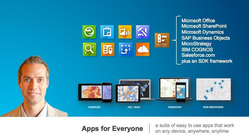
1 Federal GIS Conference February 9 10, 2015 Washington, DC ArcGIS Apps: An Overview Chris LeSueur Product Manager Marisa Cowdry NCMEC
2 Agenda Apps Introduction Rugged Device Apps Essential Mapping Apps - Collector for ArcGIS - Demo: National Center for Missing and Exploited Children - Operations Dashboard - Explorer for ArcGIS Runtime SDKs Type Presentation Title Here

3 Type Presentation Title Here
4

5 Rugged Device Apps Type Presentation Title Here


6 ArcPad Full Featured Mobile GIS App Ad-hoc data collection projects High accuracy GPS Configurable Custom forms Fully Disconnected Users typically need GIS Training Windows 7/8 Laptops Windows Mobile handhelds


7 ArcGIS for Windows Mobile Configurable workflows High accuracy GPS Custom forms Fully disconnected ArcGIS Online/ArcGIS Server Packaging and Deployment Users typically need little training - Applications are extensible! Windows 7/8 Laptops Windows Mobile handhelds

8 Essential Mapping Apps
9 Essential Mapping Apps Drive adoption of the ArcGIS platform Target a specific customer need Intuitive and easy to use Planning/ Decision Making Field Mobility Operational Awareness Business Integration Public Engagement
10 Essential Mapping Apps Configurable Cloud and on-premises Cross-platform

11 Collector for ArcGIS
12 What is Collector for ArcGIS? Use GPS to capture location Collect asset location and status Perform inspections and surveys Download maps to your device Fill out forms Capture photos and video


13 Collector for ArcGIS What can you use it for: - Collect asset locations and status - Ground-truth their GIS data - Make observations/conduct surveys - Replace paper-based forms/process
14 Tips for Making your map Add your layers to your map Configure the map: forms, symbology, tools Share to your field users Only show the fields that the end user needs Turn off tools the user wont use to do their job (measure, basemap etc) Use scale dependency to hide read only layers till they re needed Side load basemaps to device to save time Collector for ArcGIS: An Introduction
15 Supported Download Workflows Collector user can download map areas to their device Choose area to download Download the map Disconnect and Collect data Connect and sync Field managers can optimize that workflow by packaging and sideloading basemaps
16 Demo National Center for Missing and Exploited Children Type Presentation Title Here

17 The Collector Application at NCMEC Nick Rodriguez Sr. Assistant Case Man Marisa Cowdry Data Analytics Integration Specialist, TSD
18 NCMEC s History Established in 1984, the National Center for Missing & Exploited Children (NCMEC) is the leading nonprofit organization in the U.S. working with law enforcement, families and the professionals who serve them on issues related to missing and sexually exploited children. As part of its Congressional authorization, NCMEC has created a unique public and private partnership to build a coordinated, national response to the problem of missing and sexually exploited children, establish a missing children hotline and serve as the national clearinghouse for information related to these issues.
19 Key Facts and NCMEC Stats In a National report completed by the State Department and published in 2002, Approximately 800,000 children younger than 18 were reported missing. In 2013, there were 462,567 entries for missing children under the age of 18 into the FBI's National Crime Information Center, also called NCIC. The National Center for Missing & Exploited Children has assisted law enforcement in the recovery of more than 202,667 missing children since it was founded in Our recovery rate for missing children has grown from 62 percent in 1990 to 97 percent today. As of October 2014, the CyberTipline has received more than 2.8 million reports of suspected child sexual exploitation since it was launched in 1998.

20 Esri s Platform Through Esri s ArcGIS online, ArcGIS Desktop, and Collector Application we are able to arm our people in the field with the ability to view geospatial data and conduct geospatial analysis. In addition, these tools equip them with a way to document new data collected in the field and swiftly push it back to Headquarters.
21 Live Demo
22 Highlights The Esri Platform allows NCMEC to provide a visual representation of data that we collect and store. Allows us to analyze data in a geospatial way, which in return allows us to provide law enforcement better reports. Allows us to filter other data sets based on case development unlike ever before. Integrate data from multiple different sources and access them all in one place. Allows us to collect and document information obtained in the field in real time. In addition it allows us to preserve such information. Facilitates collaboration between the consultants
23 Contact Information Nick Rodriguez Sr. Assistant Case Manager, MCD National Center for Missing & Exploited Children (571) Marisa Cowdry Data Analytics Integration Specialist National Center for Missing & Exploited Children 703)
24 10.3 Release Collector for ArcGIS Default Field Edits Field Edits Versioned Editing Editing Controls Related Tables
25 Operations Dashboard for ArcGIS


26 Operations Dashboard for ArcGIS Monitor daily operations Manage events Visualize key performance indicators Ready-to-use widgets Create and share common operating views Windows desktop and browsers
27 Operations Dashboard for ArcGIS Ready to use widgets anyone can configure - Maps, Lists - Bar Charts, Gauges - Histograms, Indicators - Details Extensible using WPF SDK Create and Share Views Laptops Tablets Ops Center

28 Operations Dashboard in a Browser! Author in Windows desktop application open in a browser Single display operation view Author in Windows Open in Browser All widgets, feature actions and map tools supported
29 Demo Type Presentation Title Here

30 Explorer for ArcGIS


31 What is Explorer for ArcGIS? Personalizes your experience with ArcGIS Discover maps and data Collaborate and share Present maps and projects


")
32 Multiple platforms ios (iphone and ipad) Mac OS X Android (phones and tablets) Future Windows Windows


33 Explorer for ArcGIS What you can do: - Discover and Use Maps - Search and Explore data - Present, Share and Collaborate using Maps

34 Discover Maps A Personalized Experience for Working with Maps Use the maps you work with every day - Favorites - My Maps - My Groups - Recently used Search for Maps within your organization - Featured and newest maps Map Information - View map details - Add maps to your favorites


35 Use and Search the Map Key features for using maps - Measure Distances and Areas - View Feature Details - Change basemaps - Bookmarks, My Places, Contacts Search the map for - Places - Features - Locations by coordinate notation - Search suggestions
 - Directly")

36 Share and Collaborate Share maps - Within your organization (groups, everyone) - Directly with others ( , Text Message, AirDrop) Collaborate - Sketch on the map - View presentations
37 Demo Type Presentation Title Here
38 What s Coming Next with Explorer for ArcGIS More Capabilities - Make maps and layers - 3D support for web scenes (viewing, presentations) - Offline Download, view and use the map offline - Template-based feature editing Simple point, line poly data editing
39 Runtime SDKs Esri UC 2014 Technical Workshop Type Presentation Title Here
 ios (Objective C) Android (Java) Java SE Qt Windows Phone (SL, XAML) Windows (Win Store) Windows (WPF) Core ArcGIS Runtime Components Geometry Sync Framework Graphics")
40 Device Platform Strategy Configurable Apps ArcGIS for ios, Android, Windows Phone Collector for ArcGIS Operations Dashboard Explorer for ArcGIS ArcGIS Runtime SDKs.NET SDK Mac OS X (Objective C) ios (Objective C) Android (Java) Java SE Qt Windows Phone (SL, XAML) Windows (Win Store) Windows (WPF) Core ArcGIS Runtime Components Geometry Sync Framework Graphics Symbols Map Grids Spatial Reference Feature Cache Tiles Messaging 3D Map Display More
41 Apps Sessions Collector for ArcGIS: An Overview - Tuesday, 10 Feb 2015, 1:30pm - 2:30pm - Location: 207 B Operations Dashboard for ArcGIS: An Overview - Tuesday, 10 Feb 2015, 11:00am - 12:00pm - Location: 207 B Explorer for ArcGIS: An Overview - Tuesday, 10 Feb 2015, 5:15pm - 6:15pm - Location: 103 A ArcGIS Apps: The Road Ahead - Tuesday, 10 Feb 2015, 2:45pm - 3:45pm - Location: 103 A


42
Using Collector for ArcGIS and Operations Dashboard for ArcGIS. Mike Sweeney Esri-Charlotte
 Using Collector for ArcGIS and Operations Dashboard for ArcGIS Mike Sweeney Esri-Charlotte Agenda The ArcGIS Platform Desktop Web Device Portal Cloud Server Online Content and Services On-Premises Available
An Introduction to GIS for developers
 An Introduction to GIS for developers Part 4: GIS Sharing Canserina Kurnia & Tom Shippee Agenda Web GIS ArcGIS Online Cloud-based ArcGIS Server ArcGIS Server on-premises ArcGIS a complete platform discover,
ArcGIS for Mobile Devices: An Overview. Jeff Shaner Bonnie Stayer
 ArcGIS for Mobile Devices: An Overview Jeff Shaner Bonnie Stayer Agenda Esri Positioning and Key Benefits Your Mobility Strategy Q & A Positioning and Benefits Key Benefits of Mobile Solutions Leverage
Collector for ArcGIS. Paul Barker Bert Yagrich
 Collector for ArcGIS Paul Barker Bert Yagrich Agenda What are we going to cover today? ArcGIS as a platform for data collection Device strategy and field data collection Collector for ArcGIS an overview
Collector for ArcGIS. Paul Barker and Russ Roberts
 Collector for ArcGIS Paul Barker and Russ Roberts Agenda A quick look at the mobile landscape ArcGIS the platform Looking at the problem What is Collector for ArcGIS Demo Quick tips What s next? Questions
ArcPad An Introduction
 2013 Esri International User Conference July 8 12, 2013 San Diego, California Technical Workshop ArcPad An Introduction Chris LeSeuer, Marika Vertzonis, Hannah Ferrier Esri UC2013. Technical Workshop.
Getting Started with ArcGIS Runtime. Jeff Shaner David Cardella
 Getting Started with ArcGIS Runtime Jeff Shaner David Cardella Agenda ArcGIS Runtime SDK Overview WPF SDK Java SDK ios, Android, Win Phone SDKs Road Ahead Making ArcGIS available from any device anywhere
Building Applications with the ArcGIS Runtime SDK for WPF
 Esri International User Conference San Diego, California Technical Workshops 24 th July 2012 Building Applications with the ArcGIS Runtime SDK for WPF Euan Cameron & Paul Pilkington Agenda Introduction
Developing Qt Apps with the Runtime SDK
 Developing Qt Apps with the Runtime SDK Thomas Dunn and Michael Tims Esri UC 2014 Technical Workshop Agenda Getting Started Creating the Map Geocoding and Routing Geoprocessing Message Processing Work
Collector for ArcGIS: What s New. Chris LeSueur & James Tedrick
 Collector for ArcGIS: What s New Chris LeSueur & James Tedrick Outline Product overview Workflows Preparing data for Collector for ArcGIS What s new in Collector for ArcGIS v18.1.0 (Aurora) Advanced topics
Deploying ios Apps. Al Pascual
 Deploying ios Apps Al Pascual Overview Device Platform Strategy Built from a common GIS Runtime Configurable Apps ArcGIS for ios, Android, Windows Phone Collector for ArcGIS Operations Dashboard Additional
Getting Started with the ArcGIS Runtime SDKs. Dave, Will, Euan
 Getting Started with the ArcGIS Runtime SDKs Dave, Will, Euan Agenda Why native app development? What can you do with the runtime SDKs Latest release Future Native Apps Are Everywhere Apple s App Store
ArcGIS App Strategies Ben
 ArcGIS App Strategies Ben Ramseth Bramseth@esri.com @esrimapninja DevSummit DC February 26, 2016 Washington, DC Session overview Topics Understanding ArcGIS s Defining strategies for building s Applying
Developing mapping applications with ArcGIS Runtime SDK for ios. Divesh Goyal Eric Ito
 Developing mapping applications with ArcGIS Runtime SDK for ios Divesh Goyal Eric Ito Agenda Directions & Navigation Finding places and addresses Accessing your map content What is a mapping app? Introduction
Administering Your ArcGIS Enterprise Portal Bill Major Craig Cleveland
 Administering Your ArcGIS Enterprise Portal Bill Major Craig Cleveland Agenda Welcome & Introduction to ArcGIS Enterprise Portal for ArcGIS Administration - Basic Configuration - Advanced Configuration
An introduction to ArcGIS Runtime
 2013 Europe, Middle East, and Africa User Conference October 23-25 Munich, Germany An introduction to ArcGIS Runtime Christine Brunner Lars Schmitz Welcome! Christine Brunner, Germany - Software Developer
A Developers Guide To Mobile GIS. David Cardella, Jeff Shaner
 A Developers Guide To Mobile GIS David Cardella, Jeff Shaner What is mobile GIS? Extends the reach of ArcGIS from the office to the field With a mobile GIS solution you can: - Carry your maps to the field
ArcGIS Runtime SDK for Java: A Beginner s Guide. Mark Baird JC Malott
 ArcGIS Runtime SDK for Java: A Beginner s Guide Mark Baird JC Malott Outline Intro to ArcGIS Runtime SDKs Get started: download and install the SDK Tour of the functionality of the API Basics of building
Building Apps with the ArcGIS Runtime SDK for ios
 Building Apps with the ArcGIS Runtime SDK for ios Nick Furness @geeknixta ArcGIS Runtime SDKs 10.2 Released! Runtime platforms OS X Desktop Desktop Client Windows Store QT ios.net JavaSE Mobile Android
Developing Mobile Apps with the ArcGIS Runtime SDK for.net
 Developing Mobile Apps with the ArcGIS Runtime SDK for.net Rich Zwaap Morten Nielsen Esri UC 2014 Technical Workshop Agenda The ArcGIS Runtime Getting started with.net Mapping Editing Going offline Geocoding
Building Java Apps with ArcGIS Runtime SDK
 Building Java Apps with ArcGIS Runtime SDK Mark Baird and Vijay Gandhi A step back in time Map making 50 years ago - http://www.nls.uk/exhibitions/bartholomew/maps-engraver - http://www.nls.uk/exhibitions/bartholomew/printing
ArcGIS Runtime SDK for.net Getting Started. Jo Fraley
 ArcGIS Runtime SDK for.net Getting Started Jo Fraley Agenda What is the ArcGIS Runtime? What s new for ArcGIS developers? ArcGIS Runtime SDK 10.2 for WPF ArcGIS Runtime SDK for.net Building Windows Store
ICIT. Brian Hiller ESRI Account Manger. What s new in ArcGIS 10
 ICIT Brian Hiller ESRI Account Manger What s new in ArcGIS 10 ArcGIS 10 Fast Easy Powerful Everywhere late June 2010 ArcGIS System for Geographic Information Desktop Server Mobile Online A System A Complete
ArcGIS Apps for the Mobile Worker. Presented by: Sue Enyedy-Goldner
 ArcGIS Apps for the Mobile Worker Presented by: Sue Enyedy-Goldner Agenda 1. Overview of ArcGIS apps for mobile workflows 2. Considerations for configuring the best app for your workflow 3. Configuration
Configuring ArcGIS Enterprise in Disconnected Environments
 Configuring ArcGIS Enterprise in Disconnected Environments BILL MAJOR Disconnected Environments Not everyone has internet access? How many of you run disconnected today, i.e. no internet access? Many customers
Collector for ArcGIS Preparing for and Working in a disconnected environment
 Collector for ArcGIS Preparing for and Working in a disconnected environment Peter Nasuti, Dan Moore, Nicholas Davis Topics Covered With demonstrations throughout each step 1) What is Collector? What can
ArcGIS Apps for the Mobile Worker. Presented by: Sue Enyedy-Goldner
 ArcGIS Apps for the Mobile Worker Presented by: Sue Enyedy-Goldner Agenda 1. Overview of ArcGIS apps for mobile workflows 2. Considerations for configuring the best app for your workflow 3. Configuration
ArcGIS Runtime SDK for.net Building Apps. Rex Hansen
 ArcGIS Runtime SDK for.net Building Apps Rex Hansen Thank You to Our Sponsors Agenda Overview of the ArcGIS Runtime SDK for.net Resources for developers Common developer workflows: App templates, NuGet
Getting Started with ArcGIS Runtime SDK for Qt. Thomas Dunn & Nandini Rao
 Getting Started with ArcGIS Runtime SDK for Qt Thomas Dunn & Nandini Rao Agenda Getting Started Creating the Map Geocoding and Routing Geoprocessing Message Processing Work Offline The Next Release ArcGIS
ArcGIS Apps for the Mobile Worker. Presented by: Sue Enyedy-Goldner
 ArcGIS Apps for the Mobile Worker Presented by: Sue Enyedy-Goldner Agenda 1. Overview of ArcGIS apps for mobile workflows 2. Considerations for configuring the best app for your workflow 3. Configuration
ArcGIS Enterprise: Portal Administration BILL MAJOR CRAIG CLEVELAND
 ArcGIS Enterprise: Portal Administration BILL MAJOR CRAIG CLEVELAND Agenda Welcome & Introduction to ArcGIS Enterprise Portal for ArcGIS - Basic Configuration - Advanced Configuration - Deploying Apps
3D in the ArcGIS Platform. Chris Andrews
 3D in the ArcGIS Platform Chris Andrews Geospatial 3D is already all around us 3D is expanding the GIS community s opportunity to provide value 3D City & Infrastructure Models Generated 3D features Photogrammetrc
ArcGIS Runtime: Building Cross-Platform Apps. Rex Hansen Mark Baird Michael Tims Morten Nielsen
 ArcGIS Runtime: Building Cross-Platform Apps Rex Hansen Mark Baird Michael Tims Morten Nielsen Agenda Cross-platform review ArcGIS Runtime cross-platform options - Java - Qt -.NET ArcGIS Runtime: Building
Sharing Web Layers and Services in the ArcGIS Platform. Melanie Summers and Ty Fitzpatrick
 Sharing Web Layers and Services in the Platform Melanie Summers and Ty Fitzpatrick Agenda Platform overview - Web GIS information model - Two deployment options Pro Sharing - User experience and workflows
Collector for ArcGIS
 Collector for ArcGIS Field GIS Taking GIS Beyond the Office Collecting Data Reporting Observations Managing Work Connecting the Field with the Enterprise Field Mobility Solutions Improve accuracy and currency
ArcGIS Online. The Road Ahead Geoff Mortson
 ArcGIS Online The Road Ahead Geoff Mortson gmortson@esricanada.com ArcGIS Online Easily create and share maps Delivered as intelligent maps Access on virtually any device anyone, anywhere Compliments and
ArcPad An Introduction
 ArcPad An Introduction Chris LeSueur, Marika Vertzonis, Hannah Ferrier ArcPad Sessions at the UC Demo Theatre - Preparing and Deploying Data to ArcPad - Using ArcPad in the Field - Customizing ArcPad without
ESRI Mobile GIS Solutions Overview. Justin Fan
 ESRI Mobile GIS Solutions Overview Justin Fan Agenda Mobile GIS challenges ESRI Mobile GIS solutions ArcPad ArcGIS Mobile ArcGIS Engine Selecting a mobile GIS solution Q & A Objective To help you select
ArcGIS Online: Managing Data. Jeremy Bartley Sentha Sivabalan
 ArcGIS Online: Managing Data Jeremy Bartley (jbartley@esri.com) Sentha Sivabalan (ssivabalan@esri.com) Agenda Creating and managing content like Apps, Maps, Scenes and Layers in ArcGIS Today s Topics:
Working with Feature Layers. Russell Brennan Gary MacDougall
 Working with Feature Layers Russell Brennan Gary MacDougall Working with Feature Layers Session will focus on feature access and editing Highlight new features added over the last few releases Agenda Introduction
Advances in GIS help create Smarter Communities
 Advances in GIS help create Smarter Communities POP(ovich) Quiz Who is a Desktop User? Who is an ArcGIS Online User? Who is a ArcGIS Server Admin? Who is a Programmer? Who works with or for a government
Understanding ArcGIS Online - why organizations should embrace the cloud now
 Understanding ArcGIS Online - why organizations should embrace the cloud now Presented to: GeoAlberta - workshop Presented by: David Parry September 25, 2013 Today s Agenda Introduction - Why the Cloud?
ArcGIS Runtime: Working with Maps Online and Offline. Will Crick Justin Colville [Euan Cameron]
![ArcGIS Runtime: Working with Maps Online and Offline. Will Crick Justin Colville [Euan Cameron]](/thumbs/72/66940731.jpg "ArcGIS Runtime: Working with Maps Online and Offline. Will Crick Justin Colville [Euan Cameron]") ArcGIS Runtime: Working with Maps Online and Offline Will Crick Justin Colville [Euan Cameron] ArcGIS Runtime session tracks at Dev Summit 2017 ArcGIS Runtime SDKs share a common core, architecture and
ArcGIS Runtime: Working with Maps Online and Offline Will Crick Justin Colville [Euan Cameron] ArcGIS Runtime session tracks at Dev Summit 2017 ArcGIS Runtime SDKs share a common core, architecture and
Trimble GeoCollector for ArcGIS: An Introduction. Morgan Zhang (Esri), Matthew Morris (Trimble)
, Matthew Morris (Trimble)") Trimble GeoCollector for ArcGIS: An Introduction Morgan Zhang (Esri), Matthew Morris (Trimble) Overview Introduction to mobile GIS Overview of ArcGIS for Windows Mobile Overview of Trimble Positions software
Trimble GeoCollector for ArcGIS: An Introduction Morgan Zhang (Esri), Matthew Morris (Trimble) Overview Introduction to mobile GIS Overview of ArcGIS for Windows Mobile Overview of Trimble Positions software
ArcGIS for Mobile An Introduction. Bonnie Stayer
 ArcGIS for Mobile An Introduction Bonnie Stayer Benefits of mobile GIS? Accessibility Timely Decisionmaking Efficiency and Accuracy Rapid Data Collection Types of mobile solutions? Apps & APIs Functionality
ArcGIS Runtime SDK for.net: Building Xamarin Apps. Rich Zwaap Thad Tilton
 ArcGIS Runtime SDK for.net: Building Xamarin Apps Rich Zwaap Thad Tilton ArcGIS Runtime session tracks at DevSummit 2018 ArcGIS Runtime SDKs share a common core, architecture and design Functional sessions
ArcGIS Runtime SDK for WPF
 Esri Developer Summit in Europe November 9 th Rotterdam ArcGIS Runtime SDK for WPF Mike Branscomb Mark Baird Agenda Introduction SDK Building the Map Query Spatial Analysis Editing and Geometry Programming
Getting Started with ArcGIS Runtime SDK for the Microsoft.NET Framework. Morten Nielsen Mike Branscomb Antti Kajanus Rex Hansen
 Getting Started with ArcGIS Runtime SDK for the Microsoft.NET Framework Morten Nielsen Mike Branscomb Antti Kajanus Rex Hansen Agenda What is the ArcGIS Runtime? ArcGIS Runtime SDK for.net - Platform -
ArcGIS Runtime SDK for Qt: Building Apps. Koushik Hajra and Lucas Danzinger
 ArcGIS Runtime SDK for Qt: Building Apps Koushik Hajra and Lucas Danzinger Cross-platform apps Agenda for today Intro to Qt Framework and ArcGIS Runtime SDK for Qt App design patterns with this SDK SDK
Building Applications with ArcGIS Runtime SDK for ios - Part I. Divesh Goyal Mark Dostal
 Building Applications with ArcGIS Runtime SDK for ios - Part I Divesh Goyal Mark Dostal Agenda The ArcGIS System Using the Runtime SDK for ios - Display Maps - Perform Analysis - Visualize Results Q&A
ArcGIS Runtime SDKs Building Offline Apps. Nick Furness
 ArcGIS Runtime SDKs Building Offline Apps Nick Furness Agenda The basics - Considerations - Building blocks - Service types New! Offline maps New! Preplanned workflow What we are covering and what not
What Makes a good content item GREAT?
 What Makes a good content item GREAT? Keith VanGraafeiland Tuesday - 4:30 PM - 5:15 PM SDCC - Demo Theater 04 - Living Atlas Overview Subhead Here Content items in ArcGIS Online Difficult to find what
ArcGIS Runtime SDK for ios and macos: Building Apps. Suganya Baskaran, Gagandeep Singh
 ArcGIS Runtime SDK for ios and macos: Building Apps Suganya Baskaran, Gagandeep Singh Get Started Core Components Agenda - Display Map Content - Search for Content - Perform Analysis - Edit Content Summary
No Programming Required Create web apps rapidly with Web AppBuilder for ArcGIS
 No Programming Required Create web apps rapidly with Web AppBuilder for ArcGIS By Derek Law, Esri Product Manager, ArcGIS for Server Do you want to build web mapping applications you can run on desktop,
ArcGIS Runtime: Building Cross-Platform Apps. Mike Branscomb Michael Tims Tyler Schiewe
 ArcGIS Runtime: Building Cross-Platform Apps Mike Branscomb Michael Tims Tyler Schiewe Agenda Cross-platform review ArcGIS Runtime cross-platform options - Java - Qt -.NET Native vs Web Native strategies
ArcGIS Viewer for Microsoft Silverlight An Introduction
 Esri International User Conference San Diego, CA Technical Workshops July 12, 2011 ArcGIS Viewer for Microsoft Silverlight An Introduction Art Haddad, Rich Zwaap, and Derek Law Agenda Background Product
What is new in ArcGIS 10.2.x for Server
 What is new in ArcGIS 10.2.x for Server Ismael Chivite, Greg Tieman Esri UC 2014 Technical Workshop Map cache status Windows and Linux friendly Simplified architecture 64 bit Performance Improvements Administration
Building WPF Apps with the new ArcGIS Runtime SDK for.net. Antti Kajanus Mike Branscomb
 Building WPF Apps with the new ArcGIS Runtime SDK for.net Antti Kajanus Mike Branscomb Agenda ArcGIS Runtime SDK for.net Windows Desktop API Build a map Edit Search Geocoding and Routing Perform analysis
Optimizing Field Operations. Jeff Shaner
 Optimizing Field Operations Jeff Shaner Field GIS Taking GIS Beyond the Office Collecting Data Reporting Observations Managing Work Connecting the Field with the Enterprise Workforce for ArcGIS Field workforce
Introducing Survey123 For ArcGIS
 FedGIS Conference February 24 25, 2016 Washington, DC Introducing Survey123 For ArcGIS James Tedrick, Esri Jawameer Kakakhan, UN OCHA Configurable Solutions That Work Together Vizualize Collect Navigator
Using ArcGIS for Server. Javier Abadía, Esri España Peter McDaid, Esri UK
 Using ArcGIS for Server Javier Abadía, Esri España Peter McDaid, Esri UK 1. Intro 2. ArcGIS for Server = Geospatial Apps Server 3. Map Services Publishing Flow Apps 4. Spatial Functionality Services Publishing
Customizing the Operations Dashboard for ArcGIS
 2013 Esri International User Conference July 8 12, 2013 San Diego, California Technical Workshop Customizing the Operations Dashboard for ArcGIS Kylie Donia and Tif Pun Esri UC2013. Technical Workshop.
Introduction to Web AppBuilder for ArcGIS: JavaScript Apps Made Easy
 Introduction to Web AppBuilder for ArcGIS: JavaScript Apps Made Easy Jianxia Song & Derek Law July 21, 2015 Agenda Product overview Web AppBuilder for ArcGIS tour What s New July 2015 ArcGIS Online update
Standardized Data Production Strategies Across Your Enterprise
 Federal GIS Conference February 9 10, 2015 Washington, DC Standardized Data Production Strategies Across Your Enterprise Amber Bethell Sherry Fagin Authoritative content producers Knowledge Workers Executive
Introduction to ArcPad
 Introduction to ArcPad Jennifer McKee Prepared by: With support from: NSF DUE-090270 in partnership with: Mobile GIS Allows field staff to capture, update, analyze spatial data Extends reach of the office
Getting Started with ArcGIS Runtime SDK for Java SE
 Getting Started with ArcGIS Runtime SDK for Java SE Elise Acheson, Vijay Gandhi, and Eric Bader Demo Source code: https://github.com/esri/arcgis-runtime-samples-java/tree/master/devsummit-2014 Video Recording:
ArcGIS Runtime SDK for.net Building Apps. Antti Kajanus David Cardella
 ArcGIS Runtime SDK for.net Building Apps Antti Kajanus akajanus@esri.com David Cardella dcardella@esri.com Thank You to Our Generous Sponsor SDK Highlights High-performance 2D and 3D mapping Integration
Tom Brenneman. Good morning and welcome, introductions and thank you for being here.
 Welcome Tom Brenneman Good morning and welcome, introductions and thank you for being here. This is a best practices seminar. We're going to be sharing with you what we found to be best practices that
Creating Transparency, Openness and Trust: Modern Approach to Redistricting
 Creating Transparency, Openness and Trust: Modern Approach to Redistricting Richard Leadbeater, Esri Jerry Howe, Utah Legislature Larry Boden, Esri NCSL Legislative Summit Sunday, Aug. 6 11:15 am-12:15
Developing Cross-Platform Native Apps with AppStudio for ArcGIS. Jo Fraley Erwin Soekianto
 Developing Cross-Platform Native Apps with AppStudio for ArcGIS Jo Fraley Erwin Soekianto AppStudio for ArcGIS ios Android Linux 1App Windows Mac What is AppStudio for ArcGIS? A suite of productivity tools
ArcGIS Runtime: Building 3D Apps. Rex Hansen Adrien Meriaux
 ArcGIS Runtime: Building 3D Apps Rex Hansen Adrien Meriaux Agenda 3D across the ArcGIS Platform 3D in ArcGIS Runtime Road ahead ArcGIS 3D helps customers Create and Manage Design and Simulate Visualize
What s New in ArcGIS Server 10
 What s New in ArcGIS Server 10 Derek Law ArcGIS Server Product Management What s s new in ArcGIS Server 10? Agenda Highlights: Enhanced Web mapping More powerful server-based analysis Geo-collaboration
Getting Started with ArcGIS for Server. Charmel Menzel and Ken Gorton
 Getting Started with ArcGIS for Server Charmel Menzel and Ken Gorton Agenda What is ArcGIS for Server? Types of Web services Publishing resources onto the Web Clients to ArcGIS for Server Editions and
Data Store Management Best Practices. Bill Major Laurence Clinton
 Data Store Management Best Practices Bill Major Laurence Clinton Session Agenda 1. Overview 2. Installation and Configuration 3. Backing up the data store 4. Restoring the data store 5. Moving data store
Best Development Practices and Patterns Using ArcGIS Runtime SDK for Android. Xueming Wu Puneet Prakash
 Best Development Practices and Patterns Using ArcGIS Runtime SDK for Android Xueming Wu Puneet Prakash Agenda Introduction Developer Popup Feature Highlight & Drawing Order Road Ahead for the Runtime SDKs
Esri Maps for SharePoint
 Esri International User Conference San Diego, California Technical Workshops July, 2012 Esri Maps for SharePoint Art Haddad Nathan Bennett Agenda Location Analytics - Esri Maps for SharePoint - Overview
Mobile Solutions. Christopher Grasteit CA/NV/HI Technical Marketing ESRI
 Mobile Solutions Christopher Grasteit CA/NV/HI Technical Marketing ESRI Agenda GIS in the field or office? Considerations ArcPad 7.1 Overview ArcPad 7.1 Highlights Wrap up ArcGIS Engine Applications ArcGIS
ArcGIS Online: Best Practices for High-Demand Web Applications. Kelly Gerrow-Wilcox Bonnie Stayer Beth Romero
 ArcGIS Online: Best Practices for High-Demand Web Applications Kelly Gerrow-Wilcox Bonnie Stayer Beth Romero Agenda Communicating with Maps Who do you build your apps for? Layer Types Scalability and Response
Extending ArcGIS for Server. Jon Satchwell, Esri Switzerland Cédric Despierre Corporon, Esri France
 Extending ArcGIS for Server Jon Satchwell, Esri Switzerland Cédric Despierre Corporon, Esri France Agenda Introduction Server Object Extensions Server Object Interceptors THE BIG WEBGIS PICTURE Introduction
Customizing Web AppBuilder using Third Party Products. Presented to: Esri Canada Toronto UC Presented by: Maura Daffern October 11 th, 2018
 Customizing Web AppBuilder using Third Party Products Presented to: Esri Canada Toronto UC Presented by: Maura Daffern October 11 th, 2018 Introduction Third Party Products? Who Am I? Agenda What is the
Transitioning to the ArcGIS Runtime SDK for.net. Antti Kajanus & Mike Branscomb
 Transitioning to the ArcGIS Runtime SDK for.net Antti Kajanus & Mike Branscomb Transitioning from MapObjects ArcGIS API for Silverlight ArcGIS Engine Desktop / Mobile ArcGIS Runtime SDK for WPF Mobile
Getting Started with the ArcGIS Mobile APIs. Kris Bezdecny, David Martinez Andy Gup, David Cardella
 Getting Started with the ArcGIS Mobile APIs Kris Bezdecny, David Martinez Andy Gup, David Cardella Agenda Overview ArcGIS for - ios - Windows Phone - Android Wrap up - Q and A What is mobile GIS? Extends
Creating Apps Using ArcGIS Online Templates. Matt Kennedy
 Creating Apps Using ArcGIS Online Templates Matt Kennedy Topics we will cover The publishing process Before you publish Where apps live Breakdown of apps Publishing web app templates The steps for publishing
ArcGIS Enterprise Extending Services. Bill Major
 ArcGIS Enterprise Extending Services Bill Major Agenda Introduction Geoprocessing tools Server Object Extensions Server Object Interceptors Demo APPS Desktop Web Device SHARING SERVICES Portal API DATA
Geo-enable your.net apps with ArcGIS Online and Runtime. Antti Kajanus Thad Tilton
 Geo-enable your.net apps with ArcGIS Online and Runtime Antti Kajanus Thad Tilton Topics ArcGIS Online overview Creating an ArcGIS Online developer's account Licensing and credits Uploading data and hosting
The age of location enlightenment
 The age of location enlightenment GIS in Public Safety. More than a map Chris McIntosh cmcintosh@esri.com Presentation Topics Patterns in Successful Deployments Requirements How GIS is Changing Examples
Dynamic Situational Awareness. Through Developer Applications
 Dynamic Situational Awareness Through Developer Applications Mission Focused Applications Building Apps to support operations Agile Simple High-Performance Defense Developers GIS Simplifies Working With
Collecting Data on your Phone or Tablet. Tyler Gakstatter Resource Supply LLC Lake Oswego, OR
 Collecting Data on your Phone or Tablet Tyler Gakstatter Resource Supply LLC Lake Oswego, OR Who can benefit from using smartphones and tablets? One-man show to large field crews. Create maps and push
ArcGIS Enterprise: Architecture & Deployment. Anthony Myers
 ArcGIS Enterprise: Architecture & Deployment Anthony Myers 1 2 3 4 5 Web GIS Overview of ArcGIS Enterprise Federation & Hosted Server Deployment Patterns Implementation 1 Web GIS ArcGIS Enabling GIS for
Connecting Space and Time OSIsoft & Esri
 Connecting Space and Time OSIsoft & Esri Presented by Michelle Kuiee Product Manager Frank Batke Senior Systems Engineer 2 Which of these describe your need? Operating Engineers & Analysts Environmental
ArcGIS GeoEvent Server: Making 3D Scenes Come Alive with Real-Time Data
 ArcGIS GeoEvent Server: Making 3D Scenes Come Alive with Real-Time Data Morakot Pilouk, Ph.D. Senior Software Developer, Esri mpilouk@esri.com @mpesri Agenda 1 2 3 4 5 6 3D for ArcGIS Real-Time GIS Static
Esri CityEngine and the Oculus Rift: GIS for Next-Generation Virtual Reality
 Esri CityEngine and the Oculus Rift: GIS for Next-Generation Virtual Reality Brooks Patrick Solutions Engineer 3D Markets BPatrick@esri.com Esri UC 2014 Technical Workshop The entertainment industry continues
ArcGIS for Developers: An Introduction. Moey Min Ken
 ArcGIS for Developers: An Introduction Moey Min Ken AGENDA Is development right for me? Building Apps on the ArcGIS platform Rest API & Web API Native SDKs Configurable Apps and Builders Extending the
The Road to Runtime. Mark Cederholm UniSource Energy Services Flagstaff, Arizona
 The Road to Runtime Mark Cederholm UniSource Energy Services Flagstaff, Arizona A Brief History of Field Apps at UniSource ArcExplorer Free Users can customize map symbology No GPS No Editing No custom
ArcGIS GeoEvent Server: Leveraging Stream Services. Ken Gorton RJ Sunderman
 ArcGIS GeoEvent Server: Leveraging Stream Services Ken Gorton RJ Sunderman Agenda 1 2 3 4 5 Overview of Stream Services & Stream Layers Publishing Stream Services Visualization of real-time data Sample
Collaborate. w/ ArcGIS Runtime SDK for Android
 Collaborate w/ ArcGIS Runtime SDK for Android Presenters Dan O Neill - @doneill https://github.com/doneill Shelly Gill - @shellygill https://github.com/shellygill Introduction to Esri Open Source Collaboration
Expand Your Audience through ArcGIS Online Workshop 2018 IMAGIN Conference
 Workshop 2018 IMAGIN Conference Park Place Hotel and Conference Center June 19, 2018 Welcome Introductions Logistics Bathrooms Schedule (10 am-1 pm) What is ArcGIS Online? Organizational Settings Break
Web AppBuilder Presented by
 Web AppBuilder Presented by Agenda Product overview Web AppBuilder for ArcGIS tour What s new in the ArcGIS Online June 2016 update Customization Community and Resources Summary The ArcGIS Platform enables
ArcGIS Pro: What s New in Editing and Data Management
 Federal GIS Conference February 9 10, 2015 Washington, DC ArcGIS Pro: What s New in Editing and Data Management Robert LeClair ArcGIS Pro Overview Esri FedUC 2015 Technical Workshop ArcGIS Pro: What's
Hit the Ground Running. ArcGIS Runtime SDK for Android
 Hit the Ground Running ArcGIS Runtime SDK for Android Presenters Dan O Neill - @jdoneill Xueming Wu Introduction to the Android SDK Maps & Layers Analysis & Display Information Place Search Offline Patterns