ArcGIS Runtime SDKs Building Offline Apps. Nick Furness
|
|
|
- Osborn Chambers
- 5 years ago
- Views:
Transcription


1 ArcGIS Runtime SDKs Building Offline Apps Nick Furness
2 Agenda The basics - Considerations - Building blocks - Service types New! Offline maps New! Preplanned workflow
3 What we are covering and what not We are focusing on maps and the new workflows - Previously working with layers and tables directly (still can) - Focus moved to map instead Support for offline data formats hasn t gone anywhere - Tile packages, Vector tile packages, Rasters, Geodatabases Even more data types are now supported - OGC GeoPackages, Shapefiles, Electronic Navigational Chart (ENC) - Vector tiles export Check previous session recording from video.esri.com search term : ArcGIS Runtime: Working with Maps Online and Offline


4 Design for connectivity Make connectivity part of the application strategy Connected Disconnected Occasionally connected Temporary interruptions due connection problems Plan work as if in disconnected environment
5 What is a map? Central concept in ArcGIS Can be shared between multiple applications Contains - Basemaps - Operational Layers - Symbology - Popups - Metadata Authoring is done usually outside of Runtime - Can be updated outside of client application update cycle

6 Maps workflows Connected Connected maps - Distributed through Portals On-demand map areas - Generated and downloaded on request basis Preplanned map areas - Prepackaged using ArcGIS API for Python or Geoprocessing tools - Downloaded using ArcGIS Runtime Fully disconnected maps - Authored using ArcGIS Pro - Side loaded to the devices NOTE These are main workflows so mixing these are possible and practical. Disconnected
7 Working with online maps

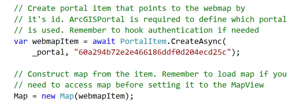
8 Supporting Text

9 Item type : webmap Tile layer Raster Tile Service Webmap Feature layer Feature layer Feature Service Map Feature layer Feature layer Item type : Feature layer Feature layer Overrides Feature Service Vector Tile layer Vector Tile Service Vector Tile layer Item type : Vector Tile Layer Vector tile layer Resources Vector Tile Service
10 Working with offline maps


11 Mobile map Map Item info Tile layer Feature layer Feature layer Feature layer overrides Feature layer overrides Vector Tile layer Vector Tile layer tpk geodatabase geodatabase vtpk Resources vtpk
12 Item type : webmap Tile layer Raster Tile Service Webmap Feature layer Feature layer Feature Service Map Feature layer Feature layer Item type : Feature layer Feature layer Overrides Feature Service Vector Tile layer Vector Tile Service Vector Tile layer Item type : Vector Tile Layer Vector tile layer Resources Vector Tile Service


13 Supported data types Vector tiles Features Feature collections Raster tiles Tables
14 Enable for offline Service authors have to enable support for offline use - Raster and Vector Tile Services NOTE You can enable offline mode at publishing time or from the service management tools. - Feature services Locators and Network datasets have to be side loaded to the device
15 On-demand workflow

16 On-demand workflow Portal Portal backend Runtime Use, collect and synchronize Author map Generate mobile data Download mobile map Runtime
17 Take map offline on-demand

18 Supporting Text
19 Preplanned workflow


20 Preplanned map areas Area 1 Area 1 Portal Item : map area Portal Items : tpks, vtpks, geodatabases Area 2 Area 2 Portal Item : map area Portal Items : tpks, vtpks, geodatabases
21 Preplanned workflow Portal Runtime Generate mobile data Use, collect and synchronize Author map and areas Download mobile map Portal backend Runtime

22 Take map offline preplanned

23 Supporting Text
24 Edit and Sync
25 How Does Sync Work? The flow of data Apply response to geodatabase Feature service with sync enabled Retrieve response Upload delta Call Sync Generate geodatabase enabled for sync Adds, edits, deletes Generate delta geodatabase
26 ArcGIS Enterprise Editing Offline Synchronize Publish Service Download Author Map Edit ArcGIS Desktop

27 ArcGIS Online Editing Offline Synchronize Author Prepare Download Edit
28 Working with disconnected maps

29 Desktop pattern Read-only workflow Mobile Map Packages authored with ArcGIS Pro Locators and network dataset needs to be created with this pattern Has to be side loaded to the clients Street Map Premium for ArcGIS offers very good dataset for disconnected scenarios - Contains basemap - Locator - Network dataset


30 Summary - Preplanned workflow is complementing the offline story not replacing it - Use Preplanned workflow if you can plan the work and/or the work is done in the same areas - Use On-demand workflow if you need to provide support for ad-hoc offline work - Try to adapt the WebGIS pattern since it is the most versatile way to provide maps that works well both in online and offline modes - Take the connectivity design as a core requirement for your system and applications - Hybrid approaches work well choose the approach based on YOUR requirements


31 Download the Esri Events app and find your event Please Take Our Survey in the Esri Events App Select the session you attended Scroll down to find the feedback section Complete answers and select Submit


32
ArcGIS Online: Three-and-a-Half Ways to Create Tile Layers. Eric Anderson & Adam Eversole Esri Support Services
 ArcGIS Online: Three-and-a-Half Ways to Create Tile Layers Eric Anderson & Adam Eversole Esri Support Services Agenda 1. Introduction 2. What is a tile layer 3. How a tile layer works 4. The 3 ½ ways to
ArcGIS Runtime SDK for Qt: Building Apps. Koushik Hajra and Lucas Danzinger
 ArcGIS Runtime SDK for Qt: Building Apps Koushik Hajra and Lucas Danzinger Cross-platform apps Agenda for today Intro to Qt Framework and ArcGIS Runtime SDK for Qt App design patterns with this SDK SDK
Working with Feature Layers. Russell Brennan Gary MacDougall
 Working with Feature Layers Russell Brennan Gary MacDougall Working with Feature Layers Session will focus on feature access and editing Highlight new features added over the last few releases Agenda Introduction
Collector for ArcGIS: What s New. Chris LeSueur & James Tedrick
 Collector for ArcGIS: What s New Chris LeSueur & James Tedrick Outline Product overview Workflows Preparing data for Collector for ArcGIS What s new in Collector for ArcGIS v18.1.0 (Aurora) Advanced topics
Building Apps with the ArcGIS Runtime SDK for ios
 Building Apps with the ArcGIS Runtime SDK for ios Nick Furness @geeknixta ArcGIS Runtime SDKs 10.2 Released! Runtime platforms OS X Desktop Desktop Client Windows Store QT ios.net JavaSE Mobile Android
Getting Started with ArcGIS Runtime SDK for Qt. Thomas Dunn & Nandini Rao
 Getting Started with ArcGIS Runtime SDK for Qt Thomas Dunn & Nandini Rao Agenda Getting Started Creating the Map Geocoding and Routing Geoprocessing Message Processing Work Offline The Next Release ArcGIS
Building Java Apps with ArcGIS Runtime SDK
 Building Java Apps with ArcGIS Runtime SDK Mark Baird and Vijay Gandhi A step back in time Map making 50 years ago - http://www.nls.uk/exhibitions/bartholomew/maps-engraver - http://www.nls.uk/exhibitions/bartholomew/printing
ArcGIS Runtime SDK for.net Building Apps. Antti Kajanus David Cardella
 ArcGIS Runtime SDK for.net Building Apps Antti Kajanus akajanus@esri.com David Cardella dcardella@esri.com Thank You to Our Generous Sponsor SDK Highlights High-performance 2D and 3D mapping Integration
Building Android Apps Runtime SDK for Android
 Building Android Apps Runtime SDK for Android Dan O Neill & Alan Lucas Introductions What do you do What do we do - Android Development Team - Edinburgh Alan Lucas - https://github.com/alan-edi - Alaska
ArcGIS Runtime: Working with Maps Online and Offline. Will Crick Justin Colville [Euan Cameron]
![ArcGIS Runtime: Working with Maps Online and Offline. Will Crick Justin Colville [Euan Cameron]](/thumbs/72/66940731.jpg "ArcGIS Runtime: Working with Maps Online and Offline. Will Crick Justin Colville [Euan Cameron]") ArcGIS Runtime: Working with Maps Online and Offline Will Crick Justin Colville [Euan Cameron] ArcGIS Runtime session tracks at Dev Summit 2017 ArcGIS Runtime SDKs share a common core, architecture and
ArcGIS Runtime: Working with Maps Online and Offline Will Crick Justin Colville [Euan Cameron] ArcGIS Runtime session tracks at Dev Summit 2017 ArcGIS Runtime SDKs share a common core, architecture and
Sharing Web Layers and Services in the ArcGIS Platform. Melanie Summers and Ty Fitzpatrick
 Sharing Web Layers and Services in the Platform Melanie Summers and Ty Fitzpatrick Agenda Platform overview - Web GIS information model - Two deployment options Pro Sharing - User experience and workflows
ArcGIS Enterprise: Sharing Imagery. Zikang Zhou Imagery and Raster team
 ArcGIS Enterprise: Sharing Imagery Zikang Zhou Imagery and Raster team ArcGIS Enterprise: Sharing Imagery PowerPoint slides will be available online. Send me an E-mail if you need it faster: zzhou@esri.com
Developing Qt Apps with the Runtime SDK
 Developing Qt Apps with the Runtime SDK Thomas Dunn and Michael Tims Esri UC 2014 Technical Workshop Agenda Getting Started Creating the Map Geocoding and Routing Geoprocessing Message Processing Work
ArcGIS Runtime SDK for Java: A Beginner s Guide. Mark Baird JC Malott
 ArcGIS Runtime SDK for Java: A Beginner s Guide Mark Baird JC Malott Outline Intro to ArcGIS Runtime SDKs Get started: download and install the SDK Tour of the functionality of the API Basics of building
Esri Developer Summit in Europe Building Applications with ArcGIS Runtime SDK for Java
 Esri Developer Summit in Europe Building Applications with ArcGIS Runtime SDK for Java Mark Baird Mike Branscomb Agenda Introduction SDK Building the Map Editing Querying Data Geoprocessing Asynchronous
ArcGIS Enterprise Extending Services. Bill Major
 ArcGIS Enterprise Extending Services Bill Major Agenda Introduction Geoprocessing tools Server Object Extensions Server Object Interceptors Demo APPS Desktop Web Device SHARING SERVICES Portal API DATA
ArcGIS Runtime: Styling Maps. Ralf Gottschalk, Daniel Lee, Lucas Danzinger
 ArcGIS Runtime: Styling Maps Ralf Gottschalk, Daniel Lee, Lucas Danzinger Map Styling What is this session about? Creating beautiful functional maps for your Runtime Apps - Not about cartography It is
ArcGIS Online: Managing Data. Jeremy Bartley Sentha Sivabalan
 ArcGIS Online: Managing Data Jeremy Bartley (jbartley@esri.com) Sentha Sivabalan (ssivabalan@esri.com) Agenda Creating and managing content like Apps, Maps, Scenes and Layers in ArcGIS Today s Topics:
Understanding and using Metadata across the ArcGIS Platform. Aleta Vienneau Marten Hogeweg
 Understanding and using Metadata across the ArcGIS Platform Aleta Vienneau Marten Hogeweg Understanding and using Metadata across the ArcGIS Platform Metadata fundamentals ArcGIS platform Road ahead Metadata
Using Collector for ArcGIS and Operations Dashboard for ArcGIS. Mike Sweeney Esri-Charlotte
 Using Collector for ArcGIS and Operations Dashboard for ArcGIS Mike Sweeney Esri-Charlotte Agenda The ArcGIS Platform Desktop Web Device Portal Cloud Server Online Content and Services On-Premises Available
Enabling High-Quality Printing in Web Applications
 Esri Developer Summit March 7 10, 2017 Palm Springs, CA Enabling High-Quality Printing in Web Applications Craig Williams & Tanu Hoque High Quality Printing on the Web Primary Goals: - Create a printable
Extending ArcGIS for Server. Jon Satchwell, Esri Switzerland Cédric Despierre Corporon, Esri France
 Extending ArcGIS for Server Jon Satchwell, Esri Switzerland Cédric Despierre Corporon, Esri France Agenda Introduction Server Object Extensions Server Object Interceptors THE BIG WEBGIS PICTURE Introduction
Bringing your Data to Life in the ArcGIS API for JavaScript: Vector Tiles. Craig Williams &
 Bringing your Data to Life in the ArcGIS API for JavaScript: Vector Tiles Craig Williams & Rene Rubalcava @williamscraigm @odoenet Overview Why vector tiles? Vector tiles in ArcGIS ArcGIS vector tile basemaps
ArcGIS Online: Best Practices for High-Demand Web Applications. Kelly Gerrow-Wilcox Bonnie Stayer Beth Romero
 ArcGIS Online: Best Practices for High-Demand Web Applications Kelly Gerrow-Wilcox Bonnie Stayer Beth Romero Agenda Communicating with Maps Who do you build your apps for? Layer Types Scalability and Response
ArcGIS Runtime SDK for WPF
 Esri Developer Summit in Europe November 9 th Rotterdam ArcGIS Runtime SDK for WPF Mike Branscomb Mark Baird Agenda Introduction SDK Building the Map Query Spatial Analysis Editing and Geometry Programming
Enabling High-Quality Printing in Web Applications. Tanu Hoque & Jeff Moulds
 Enabling High-Quality Printing in Web Applications Tanu Hoque & Jeff Moulds Print Service Technical Session Outline What s new in 10.6x What is Print Service Out of the box print solutions Print service
Developing Mobile Apps with the ArcGIS Runtime SDK for.net
 Developing Mobile Apps with the ArcGIS Runtime SDK for.net Rich Zwaap Morten Nielsen Esri UC 2014 Technical Workshop Agenda The ArcGIS Runtime Getting started with.net Mapping Editing Going offline Geocoding
Getting Started with ArcGIS Runtime SDK for Java SE
 Getting Started with ArcGIS Runtime SDK for Java SE Elise Acheson, Vijay Gandhi, and Eric Bader Demo Source code: https://github.com/esri/arcgis-runtime-samples-java/tree/master/devsummit-2014 Video Recording:
ArcGIS Apps for the Mobile Worker. Presented by: Sue Enyedy-Goldner
 ArcGIS Apps for the Mobile Worker Presented by: Sue Enyedy-Goldner Agenda 1. Overview of ArcGIS apps for mobile workflows 2. Considerations for configuring the best app for your workflow 3. Configuration
ArcGIS Apps for the Mobile Worker. Presented by: Sue Enyedy-Goldner
 ArcGIS Apps for the Mobile Worker Presented by: Sue Enyedy-Goldner Agenda 1. Overview of ArcGIS apps for mobile workflows 2. Considerations for configuring the best app for your workflow 3. Configuration
Collector for ArcGIS
 Collector for ArcGIS Field GIS Taking GIS Beyond the Office Collecting Data Reporting Observations Managing Work Connecting the Field with the Enterprise Field Mobility Solutions Improve accuracy and currency
Desktop Mapping: Creating Vector Tiles. Craig Williams
 Desktop Mapping: Creating Vector Tiles Craig Williams Edie Punt @williamscraigm @epunt Overview Why vector tiles? Vector tiles in ArcGIS ArcGIS vector tile basemaps Consuming and styling vector tiles Overview
Building Applications with the ArcGIS Runtime SDK for WPF
 Esri International User Conference San Diego, California Technical Workshops 24 th July 2012 Building Applications with the ArcGIS Runtime SDK for WPF Euan Cameron & Paul Pilkington Agenda Introduction
ArcGIS Apps for the Mobile Worker. Presented by: Sue Enyedy-Goldner
 ArcGIS Apps for the Mobile Worker Presented by: Sue Enyedy-Goldner Agenda 1. Overview of ArcGIS apps for mobile workflows 2. Considerations for configuring the best app for your workflow 3. Configuration
Getting Started with ArcGIS Runtime SDK for the Microsoft.NET Framework. Morten Nielsen Mike Branscomb Antti Kajanus Rex Hansen
 Getting Started with ArcGIS Runtime SDK for the Microsoft.NET Framework Morten Nielsen Mike Branscomb Antti Kajanus Rex Hansen Agenda What is the ArcGIS Runtime? ArcGIS Runtime SDK for.net - Platform -
ArcGIS Online. The Road Ahead Geoff Mortson
 ArcGIS Online The Road Ahead Geoff Mortson gmortson@esricanada.com ArcGIS Online Easily create and share maps Delivered as intelligent maps Access on virtually any device anyone, anywhere Compliments and
Transitioning to the ArcGIS Runtime SDK for.net. Antti Kajanus & Mike Branscomb
 Transitioning to the ArcGIS Runtime SDK for.net Antti Kajanus & Mike Branscomb Transitioning from MapObjects ArcGIS API for Silverlight ArcGIS Engine Desktop / Mobile ArcGIS Runtime SDK for WPF Mobile
ArcGIS Runtime SDKs: Building a Routing Application. Frank Kish Konstantin Kutsner
 ArcGIS Runtime SDKs: Building a Routing Application Frank Kish Konstantin Kutsner Overview What goes into a routing application Data connected \ disconnected Demo creating mmpk API Demo code Other Resources
An Introduction to GIS for developers
 An Introduction to GIS for developers Part 4: GIS Sharing Canserina Kurnia & Tom Shippee Agenda Web GIS ArcGIS Online Cloud-based ArcGIS Server ArcGIS Server on-premises ArcGIS a complete platform discover,
ArcGIS Hub: Open data best practices. Graham Hudgins, esri product engineer
 ArcGIS Hub: Open data best practices Graham Hudgins, esri product engineer Agenda Overview of open data in the ArcGIS Hub Example sites - Hubs Around the World Storymap Making a good site map Preparing
ArcGIS Runtime: Building 3D Apps. Rex Hansen Adrien Meriaux
 ArcGIS Runtime: Building 3D Apps Rex Hansen Adrien Meriaux Agenda 3D across the ArcGIS Platform 3D in ArcGIS Runtime Road ahead ArcGIS 3D helps customers Create and Manage Design and Simulate Visualize
ArcGIS Enterprise: Architecture & Deployment. Anthony Myers
 ArcGIS Enterprise: Architecture & Deployment Anthony Myers 1 2 3 4 5 Web GIS Overview of ArcGIS Enterprise Federation & Hosted Server Deployment Patterns Implementation 1 Web GIS ArcGIS Enabling GIS for
The Road to Runtime. Mark Cederholm UniSource Energy Services Flagstaff, Arizona
 The Road to Runtime Mark Cederholm UniSource Energy Services Flagstaff, Arizona A Brief History of Field Apps at UniSource ArcExplorer Free Users can customize map symbology No GPS No Editing No custom
ArcGIS Runtime SDK for Java: Building Apps. Tyler Schiewe
 ArcGIS Runtime SDK for Java: Building Apps Tyler Schiewe Agenda Getting Started API Basics Patterns & Workflows Licensing and Deployment Questions Getting Started What You Get Code API Reference (Javadoc)
Administering Your ArcGIS Enterprise Portal Bill Major Craig Cleveland
 Administering Your ArcGIS Enterprise Portal Bill Major Craig Cleveland Agenda Welcome & Introduction to ArcGIS Enterprise Portal for ArcGIS Administration - Basic Configuration - Advanced Configuration
ArcGIS Pro Terminology Guide
 ArcGIS Pro Terminology Guide Essential Terminology or Functionality That s New to ArcGIS Pro ArcGIS Pro Project Map Scene Ribbon Tab on the ribbon View Active view Pane Gallery Task Quick Access Toolbar
ArcGIS Pro Terminology Guide
 ArcGIS Pro Terminology Guide Sharing Terminology and User Interface Cross-Reference Share content Project package (.ppkx) Map package (.mpkx) Layer package (.lpkx) Share or publish a web layer Share Web
Integrating Imagery into ArcGIS Runtime Application. Jie Zhang, Zhiguang Han San Jacinto, 5:30 pm 6:30 pm
 Integrating Imagery into ArcGIS Runtime Application Jie Zhang, Zhiguang Han San Jacinto, 5:30 pm 6:30 pm Overviews Imagery is an essential component of ArcGIS - Visualization, Processing and Analysis -
Enabling High-Quality Printing in Web Applications. Tanu Hoque & Craig Williams
 Enabling High-Quality Printing in Web Applications Tanu Hoque & Craig Williams New Modern Print Service with ArcGIS Enterprise 10.6 Quality Improvements: Support for true color level transparency PDF produced
Dynamic Situational Awareness. Through Developer Applications
 Dynamic Situational Awareness Through Developer Applications Mission Focused Applications Building Apps to support operations Agile Simple High-Performance Defense Developers GIS Simplifies Working With
Creating Geoprocessing Services and Web Tools. Darren Baird, PE, Esri
 Creating Geoprocessing Services and Web Tools Darren Baird, PE, Esri Introduction Both ArcMap and ArcGIS Pro are covered Terms Geoprocessing Services and Web Tools are the same - ArcMap publishes geoprocessing
Building Basemaps: MapCaches and VectorTiles. Matthias Schenker Gerhard Trichtl
 Building Basemaps: MapCaches and VectorTiles Matthias Schenker Gerhard Trichtl What are Basemaps for Basemaps provide a optimal background and orientation for displaying your data on top Should be - Fast
ArcGIS Enterprise: An Introduction. Philip Heede
 Enterprise: An Introduction Philip Heede Online Enterprise Hosted by Esri (SaaS) - Upgraded automatically (by Esri) - Esri controls SLA Core Web GIS functionality (Apps, visualization, smart mapping, analysis
ArcGIS Runtime SDK for ios and macos: Building Apps. Suganya Baskaran, Gagandeep Singh
 ArcGIS Runtime SDK for ios and macos: Building Apps Suganya Baskaran, Gagandeep Singh Get Started Core Components Agenda - Display Map Content - Search for Content - Perform Analysis - Edit Content Summary
Trimble GeoCollector for ArcGIS: An Introduction. Morgan Zhang (Esri), Matthew Morris (Trimble)
, Matthew Morris (Trimble)") Trimble GeoCollector for ArcGIS: An Introduction Morgan Zhang (Esri), Matthew Morris (Trimble) Overview Introduction to mobile GIS Overview of ArcGIS for Windows Mobile Overview of Trimble Positions software
Trimble GeoCollector for ArcGIS: An Introduction Morgan Zhang (Esri), Matthew Morris (Trimble) Overview Introduction to mobile GIS Overview of ArcGIS for Windows Mobile Overview of Trimble Positions software
Enabling High-Quality Printing in Web Applications
 Esri Developer Summit March 8 11, 2016 Palm Springs, CA Enabling High-Quality Printing in Web Applications Craig Williams & Tanu Hoque High Quality Printing on the Web Primary Goals: - Create a printable
Best Practices for Designing Effective Map Services
 FedGIS Conference February 24 25, 2016 Washington, DC Best Practices for Designing Effective Map Services James Tedrick, Esri Matt Sokol, MD Dept. of Information Technology Web Mapping & Service Types
Collector for ArcGIS. Paul Barker Bert Yagrich
 Collector for ArcGIS Paul Barker Bert Yagrich Agenda What are we going to cover today? ArcGIS as a platform for data collection Device strategy and field data collection Collector for ArcGIS an overview
ArcGIS Enterprise: Configuring Backups, Disaster Recovery, and Replication. Harrold Sompotan and Patrick Jackson
 ArcGIS Enterprise: Configuring Backups, Disaster Recovery, and Replication Harrold Sompotan and Patrick Jackson Agenda Brief History of WebGIS DR Tool Who, Why, What, When, How and Where Considerations
Serving Imagery with ArcGIS Server 10.1
 Serving Imagery with ArcGIS Server 10.1 Presented by: André Piasta apiasta@esri.ca Esri Canada Users Conference Calgary, AB 28 May 2013 Today s Agenda ArcGIS server and image services Publishing of imagery
Collector for ArcGIS Preparing for and Working in a disconnected environment
 Collector for ArcGIS Preparing for and Working in a disconnected environment Peter Nasuti, Dan Moore, Nicholas Davis Topics Covered With demonstrations throughout each step 1) What is Collector? What can
Hit the Ground Running. ArcGIS Runtime SDK for Android
 Hit the Ground Running ArcGIS Runtime SDK for Android Presenters Dan O Neill - @jdoneill Xueming Wu Introduction to the Android SDK Maps & Layers Analysis & Display Information Place Search Offline Patterns
Python: Building Geoprocessing Tools
 FedGIS Conference February 13 14, 2017 Washington, DC Python: Building Geoprocessing Tools Michael Rhoades Frank Orr Why we build geoprocessing tools Your work becomes part of the geoprocessing framework
Leveraging metadata standards in ArcGIS to support Interoperability. Aleta Vienneau and Marten Hogeweg
 Leveraging metadata standards in ArcGIS to support Interoperability Aleta Vienneau and Marten Hogeweg Leveraging metadata standards in ArcGIS to support Interoperability Overview of metadata standards
Web AppBuilder Presented by
 Web AppBuilder Presented by Agenda Product overview Web AppBuilder for ArcGIS tour What s new in the ArcGIS Online June 2016 update Customization Community and Resources Summary The ArcGIS Platform enables
ArcGIS for Developers: An Introduction. Moey Min Ken
 ArcGIS for Developers: An Introduction Moey Min Ken AGENDA Is development right for me? Building Apps on the ArcGIS platform Rest API & Web API Native SDKs Configurable Apps and Builders Extending the
What s New in ArcGIS 10.4 for Server
 What s New in ArcGIS 10.4 for Server Derek Law, Esri Jan 19, 2016 Esri Southwest User Conference Agenda Product story GIS Server Sharing content from ArcGIS Pro Portal for ArcGIS Client Apps Summary Strongly
Building Geoprocessing Tools with Python: Beyond the Basics. Dave Wynne
 Building Geoprocessing Tools with Python: Beyond the Basics Dave Wynne Building Geoprocessing Tools with Python: Getting Started Subhead Here This session will focus on creating polished, well-designed
ArcGIS Enterprise Performance and Scalability Best Practices. Andrew Sakowicz
 ArcGIS Enterprise Performance and Scalability Best Practices Andrew Sakowicz Agenda Definitions Design workload separation Provide adequate infrastructure capacity Configure Tune Test Monitor Definitions
PYTHON: BUILDING GEOPROCESSING TOOLS. David Wynne, Andrew Ortego
 PYTHON: BUILDING GEOPROCESSING TOOLS David Wynne, Andrew Ortego http://esriurl.com/creatingtools http://esriurl.com/creatingtoolspro Today Putting it together Source code Validation Parameters Best Practices
Achieving Interoperability using the ArcGIS Platform. Satish Sankaran Roberto Lucchi
 Achieving Interoperability using the ArcGIS Platform Satish Sankaran Roberto Lucchi Thank you Please fill out the session survey in your mobile app Select [Achieving Interoperability using the ArcGIS Platform]
What Makes a good content item GREAT?
 What Makes a good content item GREAT? Keith VanGraafeiland Tuesday - 4:30 PM - 5:15 PM SDCC - Demo Theater 04 - Living Atlas Overview Subhead Here Content items in ArcGIS Online Difficult to find what
Open File Explorer Start Pro with SanFran project Open Locator in SanFran project Open Browser and AGOL with RouteExample Web map.
 Open File Explorer Start Pro with SanFran project Open Locator in SanFran project Open Browser and AGOL with RouteExample Web map. Open Browser with this: http://nadev.arcgis.com/arcgis/samples/easyvrp/easyvrp.html
ArcGIS Enterprise: Portal Administration BILL MAJOR CRAIG CLEVELAND
 ArcGIS Enterprise: Portal Administration BILL MAJOR CRAIG CLEVELAND Agenda Welcome & Introduction to ArcGIS Enterprise Portal for ArcGIS - Basic Configuration - Advanced Configuration - Deploying Apps
How To Configure & Use Insights for ArcGIS ARAVIND SIVASAILAM MATT THOMAS
 How To Configure & Use Insights for ArcGIS ARAVIND SIVASAILAM MATT THOMAS Who is this for? ArcGIS Enterprise Publishers & Administrators ArcGIS Enterprise Users (Little to No Experience with Insights)
Navigator for ArcGIS an Introduction
 Esri Developer Summit March 8 11, 2016 Palm Springs, CA Navigator for ArcGIS an Introduction Scott Sandusky Navigator for ArcGIS Navigator for ArcGIS is a mobile app that gets your field workforce where
Understanding and Using Metadata in ArcGIS. Adam Martin Marten Hogeweg Aleta Vienneau
 Understanding and Using Metadata in ArcGIS Adam Martin Marten Hogeweg Aleta Vienneau Adam Martin National Government Account Management R&D Open Data Marten Hogeweg National Government Professional Services
Building Great Situational Awareness Apps Using ArcGIS Developer Tools. Kerry Robinson Eric Bader Thomas Solow
 Building Great Situational Awareness Apps Using ArcGIS Developer Tools Kerry Robinson Eric Bader Thomas Solow Agenda Situational Awareness in ArcGIS Developing apps in connected environments - ArcGIS Enterprise
Interoperability with ArcGIS
 Interoperability with ArcGIS Satish Sankaran Marten Hogeweg Agenda Understanding Interoperability What, Why and How? ArcGIS Platform An Open Platform Supporting Interoperability Examples from the real
ArcGIS Data Reviewer: Ensuring Accurate and Complete Data to Meet Your Mission. John Grammer Kevin Pusey
 ArcGIS Data Reviewer: Ensuring Accurate and Complete Data to Meet Your Mission John Grammer Kevin Pusey Workshop agenda Defining data quality What is ArcGIS Data Reviewer? Automated review Semi-automated
Publishing image services in ArcGIS
 Esri International User Conference San Diego, California Technical Workshops July 26, 2012 Publishing image services in ArcGIS Wenxue Ju & Melanie Harlow What is an image service? A way to make image and
Enabling High-Quality Printing in Web Applications. Tanu Hoque & Scott Moore
 Enabling High-Quality Printing in Web Applications Tanu Hoque & Scott Moore High Quality Printing on the Web Create a printable document (PDF preferably) Have that document printed to exact scale Leverage
Using ArcGIS for Server. Javier Abadía, Esri España Peter McDaid, Esri UK
 Using ArcGIS for Server Javier Abadía, Esri España Peter McDaid, Esri UK 1. Intro 2. ArcGIS for Server = Geospatial Apps Server 3. Map Services Publishing Flow Apps 4. Spatial Functionality Services Publishing
ArcGIS GeoEvent Server: Making 3D Scenes Come Alive with Real-Time Data
 ArcGIS GeoEvent Server: Making 3D Scenes Come Alive with Real-Time Data Morakot Pilouk, Ph.D. Senior Software Developer, Esri mpilouk@esri.com @mpesri Agenda 1 2 3 4 5 6 3D for ArcGIS Real-Time GIS Static
Configuring ArcGIS Enterprise in Disconnected Environments
 Configuring ArcGIS Enterprise in Disconnected Environments BILL MAJOR Disconnected Environments Not everyone has internet access? How many of you run disconnected today, i.e. no internet access? Many customers
Working with Printing Service: Advanced Topics JEFF MOULDS TANU HOQUE
 Working with Printing Service: Advanced Topics JEFF MOULDS TANU HOQUE Session outline Subhead Here What is printing service and how it works? Use secured services with printing service ArcPy based printing
Introducing Survey123 For ArcGIS
 FedGIS Conference February 24 25, 2016 Washington, DC Introducing Survey123 For ArcGIS James Tedrick, Esri Jawameer Kakakhan, UN OCHA Configurable Solutions That Work Together Vizualize Collect Navigator
ArcGIS Runtime: Styling Maps. Lucas Danzinger and Michael Wilburn
 ArcGIS Runtime: Styling Maps Lucas Danzinger and Michael Wilburn What is this session about? Creating functional maps for your Runtime Apps How to design beautiful and stylish maps with an emphasis on
Survey123 Deep Dive. Presented by: Sue Enyedy-Goldner Fall 2018
 Survey123 Deep Dive Presented by: Sue Enyedy-Goldner Fall 2018 Today s Agenda 1. Overview of Survey123 - getting stared with Web Designer 2. Create smarter surveys - using Survey123 Connect 3. Examine
Desktop Mapping: Creating Vector Tiles. Craig Williams &
 Desktop Mapping: Creating Vector Tiles Craig Williams & Edie Punt @williamscraigm @epunt Overview Why vector tiles? Vector tiles in ArcGIS ArcGIS vector tile basemaps Consuming and styling vector tiles
High Availability and Disaster Recovery. Cherry Lin, Jonathan Quinn
 High Availability and Disaster Recovery Cherry Lin, Jonathan Quinn Managing the Twin Risks to your Operations Data Loss Down Time The Three Approaches Backups High Availability Disaster Recovery Geographic
ArcGIS Desktop The Road Ahead. Amadea Azerki
 ArcGIS Desktop The Road Ahead Amadea Azerki Agenda An Overview of ArcGIS 10 Desktop Enhancements User Interface Mapping Editing Analysis Sharing Q & A ArcGIS 10 Overview Focuses on Usability and Productivity
Scientific and Multidimensional Raster Support in ArcGIS
 Scientific and Multidimensional Raster Support in ArcGIS Sudhir Raj Shrestha sshrestha@esri.com Brief breakdown Scientific Multidimensional data Ingesting Scientific MultiDim Data in ArcGIS Ingesting and
Extend GIS. The Reach. Of Your GIS. Chris Cappelli Nathan Bennett
 Extend The Reach GIS Of Your GIS Chris Cappelli Nathan Bennett Where do your co-workers, managers, customers, and citizens go when they want to find or make a map? GIS is a practical system for problem
Troubleshooting Performance Issues with Enterprise Geodatabases. Ben Lin, Nana Dei, Jim McAbee
 Troubleshooting Performance Issues with Enterprise Geodatabases Ben Lin, Nana Dei, Jim McAbee blin@esri.com ndei@esri.com jmcabee@esri.com Workshop Agenda Performance Troubleshooting (Then & Now) Real-World
Understanding and Working with the OGC Geopackage. Keith Ryden Lance Shipman
 Understanding and Working with the OGC Geopackage Keith Ryden Lance Shipman Introduction - Introduction to Simple Features - What is the GeoPackage? - Esri Support - Looking ahead Geographic Things 3 Why
Implementing a Hybrid Approach to ArcGIS. Philip McNeilly and Margaret Jen
 Implementing a Hybrid Approach to ArcGIS Philip McNeilly and Margaret Jen Difficulty Level: Intermediate Overview What you will learn: - How to successfully integrate and work with services from ArcGIS
Setup Guide for Op Tracker
 Setup Guide for Op Tracker Contents 1 Welcome to Op Tracker... 2 2 Data Overview... 3 2.1 Block Boundary Feature Layer... 3 2.2 Block Tracking Feature Layer... 3 2.3 Ancillary Data Feature Layer... 3 2.4
Indexed 3D Scene (I3S) Layers Specification
 Layers Specification") Indexed 3D Scene (I3S) Layers Specification Javier Gutierrez Product Engineer Lead Esri Özgür Ertac 3D Product Engineer Esri Germany Thank You to Our Generous Sponsor Agenda ArcGIS 3D Platform Authoring
Indexed 3D Scene (I3S) Layers Specification Javier Gutierrez Product Engineer Lead Esri Özgür Ertac 3D Product Engineer Esri Germany Thank You to Our Generous Sponsor Agenda ArcGIS 3D Platform Authoring
Getting Started with ArcGIS Runtime SDK for ios and OS X. Divesh Goyal & Mary Harvey
 Getting Started with ArcGIS Runtime SDK for ios and OS X Divesh Goyal & Mary Harvey Topics Overview of Runtime Quick intro to SDK resources SDK functionality & patterns - Displaying maps - Performing analysis