ArcGIS Apps for the Mobile Worker. Presented by: Sue Enyedy-Goldner
|
|
|
- Henry Underwood
- 6 years ago
- Views:
Transcription

1 ArcGIS Apps for the Mobile Worker Presented by: Sue Enyedy-Goldner

2 Agenda 1. Overview of ArcGIS apps for mobile workflows 2. Considerations for configuring the best app for your workflow 3. Configuration strategies 4. Options on how to integrate the apps 5. Resources

3 ArcGIS Apps: Many Different Solutions Apps Key products from ArcGIS that many end-users interact with Access through ArcGIS identify Enable stakeholders to meet a need, solve a problem Toolbox analogy Different tools for different tasks to meet many different needs Desktop Apps Mobile Apps Web Apps


4 Field Operations with ArcGIS Operations Dashboard for ArcGIS ArcGIS for Desktop Drone2Map for ArcGIS Survey123 for ArcGIS Collector for ArcGIS Field Operations Workforce for ArcGIS Navigator for ArcGIS Explorer for ArcGIS
; 10.4.1; Workforce 10.5.")
5 App Requirements ArcGIS Organization account - ArcGIS Online - Portal for ArcGIS *Additional configuration required Data: support for : - Feature layers hosted on ArcGIS Online - Feature layers hosted on ArcGIS Enterprise Portal for ArcGIS (Survey123); ; Workforce Device support : - ios 8 or later: Collector, & Survey123; ios 9 or later: Navigator & Explorer) - Android (beta for Explorer) - Windows 10 (Collector, Survey123) - Windows 8 (Survey123) - Browser (Dashboard, Survey123, Workforce) For more details: docs.arc.gis.com Navigator is a Premium app for purchase (free trial available)
6 Apps that work on web maps Workforce for ArcGIS Collector for ArcGIS Explorer for ArcGIS Operations Dashboard for ArcGIS


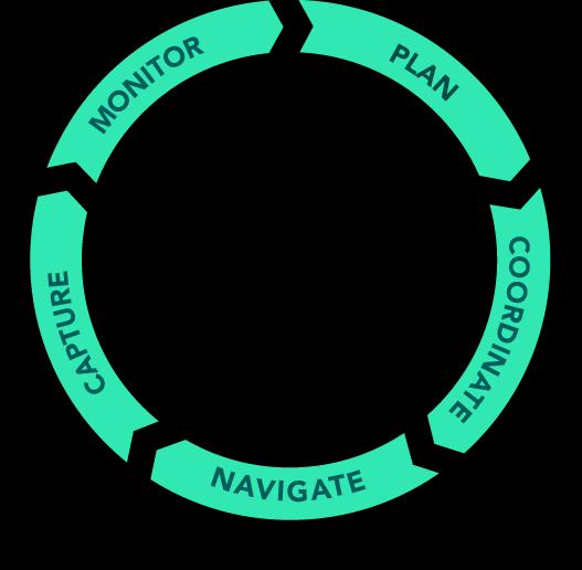
7 Workforce for ArcGIS Plan, coordinate field work Dispatcher web app: assign and monitor work - Add assets to web maps to help with work assignment Mobile App: Field staff Open an assignment Option: Navigate to it Capture data: options: Map: Collector for ArcGIS Form: Survey123 for ArcGIS Integration with other field apps Dispatcher Field Workers

8 Collector for ArcGIS Collect and Update Data in the field Collector Templates in ArcGIS Online


9 Collector: Next Generation Beta in Fall 2017 Release expected Q Will include key improvements requested by users - Better maps - Improved user experience - Smarter forms - Streamlined offline workflows - Enhancements to high accuracy 3D data collection - will be able to build upon to advance data collection workflows in the ArcGIS platform.


10 Explorer for ArcGIS Your maps anywhere Access information while disconnected Sketch, annotate, and communicate


11 Operations Dashboard: Next Generation Join Public Beta program New Dashboard home page Author in Browser, use in Browser New layout options : merging single-display & multi-display New options & more flexibility for widgets /elements especially charting
12 Web map configuration - publish from ArcGIS Desktop or ArcGIS Online - can include ArcGIS Server services - reference as items in ArcGIS Organization Collector (need an editable layer) Workforce : - Web maps created with project in Workforce Dispatcher) - Edit maps in ArcGIS Online to add operational layers, add search Best practices: - Symbology large symbols & labels to best display for apps used on device - Pop-ups: enable or disable, use aliases, hide fields not required, custom attribute display - Bookmarks

13 Web map settings Collector: Enable or disable as required by data collectors: - Routing, measuring, changing basemaps: enabled by default - finding locations: by address enabled, must turn on & set for feature search by layer - tracking location of the collectors: disabled by default - Set edit settings per layer
14 Working offline Collector offline: - Web map setting in ArcGIS Online - Prepare maps for offline use - Sync-enable feature layers - Enable offline mode in the map's item details - Optimize map for download and sync - Basemaps (offline options in documentation) Explorer offline: create mobile map package Workforce offline: future release Operations Dashboard: requires browser

15 Demonstration: Data preparation Web map configuration - Tips and tricks

16 Navigator for ArcGIS Turn by turn directions Includes network data, use with your own maps Works offline

17 Navigator for ArcGIS: Configuration Works out-of-the-box : purchase from Esri StreetMap dataset Using your own data for routing: 3 options - Requires ArcGIS Pro 1.2 or later & Network Analyst extension - Tutorial online : - modify StreetMap dataset: - Add own layers, custom geocoding locators, custom travel modes - Add your own private roads to the StreetMap dataset for routing - Create a navigation map using all your own data - Create a mobile map package and Share Package from Pro - Users access & downloads.mmpk file when logs into Navigator

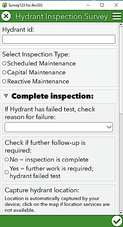

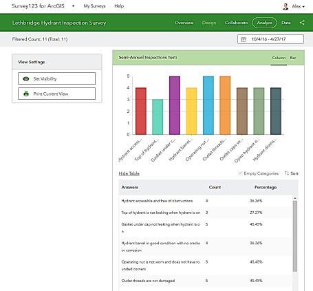

18 Survey123 for ArcGIS Form-centric field data collection Leverages Smart forms Analyze results immediately

 Advanced: use Survey123 Connect: supports full XLS")
19 Survey123: Configuration To author your surveys: 1. Use web Designer: from survey123.arcgis.com. 2. download and install Survey123 Connect on your desktop computer Which one to use? Beginners: start with web designer Easier to use: drag & drop questions Each release adds support for more types of questions Can download and open in Survey123 Connect to add advanced XLS questions (republish as new survey) Advanced: use Survey123 Connect: supports full XLS form capability Use spreadsheet: Excel for tips YouTube videos from Esri team are a good place to start
20 Demonstration: Survey123: - Create Survey from a feature service


21 ArcGIS App Integration: options Navigator can be called from Collector: Maps : Overflow > Settings > Navigation & directions: - confirm that Use Navigator for ArcGIS is selected From Explorer : Settings for Directions - Use Navigator, Apple Maps or Always Ask


22 ArcGIS App Integration Options Using Workforce for ArcGIS - Use Navigator - Associate for completing work: - Collector - Survey123 - By Assignment type
23 Custom Url scheme Using the custom url scheme: Details on Navigator: open app & map, specify designation or route starting point Survey123: open survey, pass field value to survey question Collector: open app & web map, center on location Explorer: open app & web map, center on location, address, or coordinate pair Basic parameters: arcgis-collector://?parameter=value¶meter=value Use explorer or survey123 or navigator
24 Demonstration Integration using Workforce Integration using custom url scheme for Survey123


25 Resources: Documentation - ArcGIS Apps Help (videos, tutorials) Esri Canada Blog - Getting technical blog series esri.com/videos geonet.esri.com: - Explore Products > Applications > Apps for the Field Portal configuration: - Portal for ArcGIS > Administer > Apps

26 Resources Upcoming Webinars: - Integrated Field Workflows with ArcGIS Mobile Apps November 30th Related Training Courses: Esri Canada - ArcGIS for Field Work and Operations - Building Geodatabases - Introduction to Drone2Map esri.com/training: filter by Data Collection & Management : Collect Data in the Field


27 Thank You! Happy Questions? Sue
28 2017 Esri Canada Limited. All rights reserved. Trademarks provided under license from Environmental Systems Research Institute, Inc. Other product and company names mentioned herein may be trademarks or registered trademarks of their respective owners. Errors and omissions excepted.


29
ArcGIS Apps for the Mobile Worker. Presented by: Sue Enyedy-Goldner
 ArcGIS Apps for the Mobile Worker Presented by: Sue Enyedy-Goldner Agenda 1. Overview of ArcGIS apps for mobile workflows 2. Considerations for configuring the best app for your workflow 3. Configuration
ArcGIS Apps for the Mobile Worker. Presented by: Sue Enyedy-Goldner
 ArcGIS Apps for the Mobile Worker Presented by: Sue Enyedy-Goldner Agenda 1. Overview of ArcGIS apps for mobile workflows 2. Considerations for configuring the best app for your workflow 3. Configuration
Survey123 Deep Dive. Presented by: Sue Enyedy-Goldner Fall 2018
 Survey123 Deep Dive Presented by: Sue Enyedy-Goldner Fall 2018 Today s Agenda 1. Overview of Survey123 - getting stared with Web Designer 2. Create smarter surveys - using Survey123 Connect 3. Examine
Navigator for ArcGIS an Introduction
 Esri Developer Summit March 8 11, 2016 Palm Springs, CA Navigator for ArcGIS an Introduction Scott Sandusky Navigator for ArcGIS Navigator for ArcGIS is a mobile app that gets your field workforce where
Navigator for ArcGIS Presented by
 Navigator for ArcGIS Presented by Navigator for ArcGIS Get your field workforce where it needs to be Custom data (search, route, display) Fully integrated with other apps Advanced vehicle travel modes
Using Collector for ArcGIS and Operations Dashboard for ArcGIS. Mike Sweeney Esri-Charlotte
 Using Collector for ArcGIS and Operations Dashboard for ArcGIS Mike Sweeney Esri-Charlotte Agenda The ArcGIS Platform Desktop Web Device Portal Cloud Server Online Content and Services On-Premises Available
Collector for ArcGIS: What s New. Chris LeSueur & James Tedrick
 Collector for ArcGIS: What s New Chris LeSueur & James Tedrick Outline Product overview Workflows Preparing data for Collector for ArcGIS What s new in Collector for ArcGIS v18.1.0 (Aurora) Advanced topics
Optimizing Field Operations. Jeff Shaner
 Optimizing Field Operations Jeff Shaner Field GIS Taking GIS Beyond the Office Collecting Data Reporting Observations Managing Work Connecting the Field with the Enterprise Workforce for ArcGIS Field workforce
ArcGIS Runtime SDKs Building Offline Apps. Nick Furness
 ArcGIS Runtime SDKs Building Offline Apps Nick Furness Agenda The basics - Considerations - Building blocks - Service types New! Offline maps New! Preplanned workflow What we are covering and what not
Collector for ArcGIS
 Collector for ArcGIS Field GIS Taking GIS Beyond the Office Collecting Data Reporting Observations Managing Work Connecting the Field with the Enterprise Field Mobility Solutions Improve accuracy and currency
Collector for ArcGIS. Paul Barker Bert Yagrich
 Collector for ArcGIS Paul Barker Bert Yagrich Agenda What are we going to cover today? ArcGIS as a platform for data collection Device strategy and field data collection Collector for ArcGIS an overview
Collector for ArcGIS Preparing for and Working in a disconnected environment
 Collector for ArcGIS Preparing for and Working in a disconnected environment Peter Nasuti, Dan Moore, Nicholas Davis Topics Covered With demonstrations throughout each step 1) What is Collector? What can
Customizing Web AppBuilder using Third Party Products. Presented to: Esri Canada Toronto UC Presented by: Maura Daffern October 11 th, 2018
 Customizing Web AppBuilder using Third Party Products Presented to: Esri Canada Toronto UC Presented by: Maura Daffern October 11 th, 2018 Introduction Third Party Products? Who Am I? Agenda What is the
Introducing Survey123 For ArcGIS
 FedGIS Conference February 24 25, 2016 Washington, DC Introducing Survey123 For ArcGIS James Tedrick, Esri Jawameer Kakakhan, UN OCHA Configurable Solutions That Work Together Vizualize Collect Navigator
Administering Your ArcGIS Enterprise Portal Bill Major Craig Cleveland
 Administering Your ArcGIS Enterprise Portal Bill Major Craig Cleveland Agenda Welcome & Introduction to ArcGIS Enterprise Portal for ArcGIS Administration - Basic Configuration - Advanced Configuration
An Introduction to GIS for developers
 An Introduction to GIS for developers Part 4: GIS Sharing Canserina Kurnia & Tom Shippee Agenda Web GIS ArcGIS Online Cloud-based ArcGIS Server ArcGIS Server on-premises ArcGIS a complete platform discover,
Collector for ArcGIS. Paul Barker and Russ Roberts
 Collector for ArcGIS Paul Barker and Russ Roberts Agenda A quick look at the mobile landscape ArcGIS the platform Looking at the problem What is Collector for ArcGIS Demo Quick tips What s next? Questions
Customizing Survey123 Customization & Submission URL. Kelly Fisher, Project/GIS Manager GeoDecisions
 Customizing Survey123 Customization & Submission URL Kelly Fisher, Project/GIS Manager GeoDecisions Topics/Discussions Desktop Web Device PennDOT STAMPP Review Current STAMPP Application Why Change Current
ArcGIS Runtime SDK for Qt: Building Apps. Koushik Hajra and Lucas Danzinger
 ArcGIS Runtime SDK for Qt: Building Apps Koushik Hajra and Lucas Danzinger Cross-platform apps Agenda for today Intro to Qt Framework and ArcGIS Runtime SDK for Qt App design patterns with this SDK SDK
ArcGIS Online. The Road Ahead Geoff Mortson
 ArcGIS Online The Road Ahead Geoff Mortson gmortson@esricanada.com ArcGIS Online Easily create and share maps Delivered as intelligent maps Access on virtually any device anyone, anywhere Compliments and
ArcGIS Story Map Journal Tutorial. A simple tutorial for how to create your own story map journal
 ArcGIS Story Map Journal Tutorial A simple tutorial for how to create your own story map journal Before you start In this tutorial you'll use our interactive Story Map Journal Builder to author your journal
ArcGIS Apps: An Overview
 Federal GIS Conference February 9 10, 2015 Washington, DC ArcGIS Apps: An Overview Chris LeSueur Product Manager Marisa Cowdry NCMEC Agenda Apps Introduction Rugged Device Apps Essential Mapping Apps -
ArcGIS Enterprise: Portal Administration BILL MAJOR CRAIG CLEVELAND
 ArcGIS Enterprise: Portal Administration BILL MAJOR CRAIG CLEVELAND Agenda Welcome & Introduction to ArcGIS Enterprise Portal for ArcGIS - Basic Configuration - Advanced Configuration - Deploying Apps
ArcGIS Runtime SDKs: Building a Routing Application. Frank Kish Konstantin Kutsner
 ArcGIS Runtime SDKs: Building a Routing Application Frank Kish Konstantin Kutsner Overview What goes into a routing application Data connected \ disconnected Demo creating mmpk API Demo code Other Resources
ArcGIS Online: Best Practices for High-Demand Web Applications. Kelly Gerrow-Wilcox Bonnie Stayer Beth Romero
 ArcGIS Online: Best Practices for High-Demand Web Applications Kelly Gerrow-Wilcox Bonnie Stayer Beth Romero Agenda Communicating with Maps Who do you build your apps for? Layer Types Scalability and Response
Web App Builder: Code-free Development. Adam Ziegler, Esri-Northeast, Local Government Team
 Web App Builder: Code-free Development Adam Ziegler, aziegler@esri.com Esri-Northeast, Local Government Team Agenda Product overview Web AppBuilder for ArcGIS tour Adding Custom Widgets Community and Resources
Getting Started with ArcGIS Runtime SDK for Qt. Thomas Dunn & Nandini Rao
 Getting Started with ArcGIS Runtime SDK for Qt Thomas Dunn & Nandini Rao Agenda Getting Started Creating the Map Geocoding and Routing Geoprocessing Message Processing Work Offline The Next Release ArcGIS
Working with Feature Layers. Russell Brennan Gary MacDougall
 Working with Feature Layers Russell Brennan Gary MacDougall Working with Feature Layers Session will focus on feature access and editing Highlight new features added over the last few releases Agenda Introduction
Web AppBuilder Presented by
 Web AppBuilder Presented by Agenda Product overview Web AppBuilder for ArcGIS tour What s new in the ArcGIS Online June 2016 update Customization Community and Resources Summary The ArcGIS Platform enables
Developing Qt Apps with the Runtime SDK
 Developing Qt Apps with the Runtime SDK Thomas Dunn and Michael Tims Esri UC 2014 Technical Workshop Agenda Getting Started Creating the Map Geocoding and Routing Geoprocessing Message Processing Work
ArcGIS Online: Three-and-a-Half Ways to Create Tile Layers. Eric Anderson & Adam Eversole Esri Support Services
 ArcGIS Online: Three-and-a-Half Ways to Create Tile Layers Eric Anderson & Adam Eversole Esri Support Services Agenda 1. Introduction 2. What is a tile layer 3. How a tile layer works 4. The 3 ½ ways to
Sharing Web Layers and Services in the ArcGIS Platform. Melanie Summers and Ty Fitzpatrick
 Sharing Web Layers and Services in the Platform Melanie Summers and Ty Fitzpatrick Agenda Platform overview - Web GIS information model - Two deployment options Pro Sharing - User experience and workflows
ArcGIS Online: Managing Data. Jeremy Bartley Sentha Sivabalan
 ArcGIS Online: Managing Data Jeremy Bartley (jbartley@esri.com) Sentha Sivabalan (ssivabalan@esri.com) Agenda Creating and managing content like Apps, Maps, Scenes and Layers in ArcGIS Today s Topics:
Survey123 for ArcGIS: An Introduction. James Tedrick Erin Densford
 Survey123 for ArcGIS: An Introduction James Tedrick Erin Densford Smart Forms for ArcGIS Easily convert paper forms into Digital Smart ArcGIS Forms Why Smart Forms in ArcGIS? Reduce Errors During Data
ArcGIS Online workshop Shane Clarke John Sharrard. Central Oregon GIS User Group Meeting Bend, OR January 23, 2013
 ArcGIS Online workshop Shane Clarke John Sharrard Central Oregon GIS User Group Meeting Bend, OR January 23, 2013 Introduction i. What is ArcGIS Online? ii. Exploring ArcGIS Online Transform your Organization
The Road to Runtime. Mark Cederholm UniSource Energy Services Flagstaff, Arizona
 The Road to Runtime Mark Cederholm UniSource Energy Services Flagstaff, Arizona A Brief History of Field Apps at UniSource ArcExplorer Free Users can customize map symbology No GPS No Editing No custom
HCA ArcGIS. Online Tool - How To Guide V1.0 2/15/2016 HAWAII CONSERVATION ALLIANCE AGOL
 HCA ArcGIS 2/15/2016 Online Tool - How To Guide V1.0 HAWAII CONSERVATION ALLIANCE AGOL Table of Contents What is ArcGIS Online?... 1 Getting Started... 1 Getting a Login... 1 Logging In... 2 Searching
Web AppBuilder for ArcGIS: JavaScript Apps Made Easy
 Web AppBuilder for ArcGIS: JavaScript Apps Made Easy Ryan Sellman @rcsellman Agenda Product overview Web AppBuilder for ArcGIS tour Customization Community and Resources Summary The ArcGIS Platform enables
ArcGIS for Developers: An Introduction. Moey Min Ken
 ArcGIS for Developers: An Introduction Moey Min Ken AGENDA Is development right for me? Building Apps on the ArcGIS platform Rest API & Web API Native SDKs Configurable Apps and Builders Extending the
Network Analysis with ArcGIS Online and On-premise Services
 2013 Esri International User Conference July 8 12, 2013 San Diego, California Technical Workshop Network Analysis with ArcGIS Online and On-premise Services Deelesh Mandloi Dmitry Kudinov Esri UC2013.
What s New in Imagery in ArcGIS. Presented by: Christopher Patterson Date: October 18, 2017
 What s New in Imagery in ArcGIS Presented by: Christopher Patterson Date: October 18, 2017 Imagery in ArcGIS Advancing 2010 Stretch, Extract Bands Clip, Mask Reproject, Orthorectify, Pan Sharpen Vegetation
Mobile Data Collection Using ArcGIS Online
 Mobile Data Collection Using ArcGIS Online Collector for ArcGIS: Exercise C1: Add data to an editable feature service Estimated time: 10 minutes Exercise C2: Publish an Editable Spreadsheet to ArcGIS Online
Ensuring the Deer and Antelope Play Free
 IPMA Professional Development Seminar Ensuring the Deer and Antelope Play Free A success story using Survey123 ROB SMITH DATABASE WIZARD WSDOT ENVIRONMENTAL SERVICES OFFICE JESSE ALTON GIS & DATA MANAGER
ArcGIS for Mobile Devices: An Overview. Jeff Shaner Bonnie Stayer
 ArcGIS for Mobile Devices: An Overview Jeff Shaner Bonnie Stayer Agenda Esri Positioning and Key Benefits Your Mobility Strategy Q & A Positioning and Benefits Key Benefits of Mobile Solutions Leverage
Using ArcGIS for Server. Javier Abadía, Esri España Peter McDaid, Esri UK
 Using ArcGIS for Server Javier Abadía, Esri España Peter McDaid, Esri UK 1. Intro 2. ArcGIS for Server = Geospatial Apps Server 3. Map Services Publishing Flow Apps 4. Spatial Functionality Services Publishing
No Programming Required Create web apps rapidly with Web AppBuilder for ArcGIS
 No Programming Required Create web apps rapidly with Web AppBuilder for ArcGIS By Derek Law, Esri Product Manager, ArcGIS for Server Do you want to build web mapping applications you can run on desktop,
ArcGIS Pro Terminology Guide
 ArcGIS Pro Terminology Guide Essential Terminology or Functionality That s New to ArcGIS Pro ArcGIS Pro Project Map Scene Ribbon Tab on the ribbon View Active view Pane Gallery Task Quick Access Toolbar
Trimble GeoCollector for ArcGIS: An Introduction. Morgan Zhang (Esri), Matthew Morris (Trimble)
, Matthew Morris (Trimble)") Trimble GeoCollector for ArcGIS: An Introduction Morgan Zhang (Esri), Matthew Morris (Trimble) Overview Introduction to mobile GIS Overview of ArcGIS for Windows Mobile Overview of Trimble Positions software
Trimble GeoCollector for ArcGIS: An Introduction Morgan Zhang (Esri), Matthew Morris (Trimble) Overview Introduction to mobile GIS Overview of ArcGIS for Windows Mobile Overview of Trimble Positions software
ArcGIS Pro Terminology Guide
 ArcGIS Pro Terminology Guide Sharing Terminology and User Interface Cross-Reference Share content Project package (.ppkx) Map package (.mpkx) Layer package (.lpkx) Share or publish a web layer Share Web
A Developers Guide To Mobile GIS. David Cardella, Jeff Shaner
 A Developers Guide To Mobile GIS David Cardella, Jeff Shaner What is mobile GIS? Extends the reach of ArcGIS from the office to the field With a mobile GIS solution you can: - Carry your maps to the field
ArcGIS Runtime SDK for WPF
 Esri Developer Summit in Europe November 9 th Rotterdam ArcGIS Runtime SDK for WPF Mike Branscomb Mark Baird Agenda Introduction SDK Building the Map Query Spatial Analysis Editing and Geometry Programming
ArcGIS Desktop The Road Ahead. Amadea Azerki
 ArcGIS Desktop The Road Ahead Amadea Azerki Agenda An Overview of ArcGIS 10 Desktop Enhancements User Interface Mapping Editing Analysis Sharing Q & A ArcGIS 10 Overview Focuses on Usability and Productivity
TRAINING GUIDE. Tablet: Cradle to Mobile GIS
 TRAINING GUIDE Tablet: Cradle to Mobile GIS Tablet Cradle to Mobile One of the critical components of mobile is the GIS piece, and also can be the most complex. The mobile GIS maps are designed to consume
TRAINING GUIDE. Mobile for Administrators Part 3 - GIS
 TRAINING GUIDE Mobile for Administrators Part 3 - GIS Mobile for Administrators - GIS One of the critical components of mobile is GIS, and it can also be the most complex. The mobile GIS maps are designed
3D in the ArcGIS Platform. Chris Andrews
 3D in the ArcGIS Platform Chris Andrews Geospatial 3D is already all around us 3D is expanding the GIS community s opportunity to provide value 3D City & Infrastructure Models Generated 3D features Photogrammetrc
ArcGIS Runtime: Styling Maps. Ralf Gottschalk, Daniel Lee, Lucas Danzinger
 ArcGIS Runtime: Styling Maps Ralf Gottschalk, Daniel Lee, Lucas Danzinger Map Styling What is this session about? Creating beautiful functional maps for your Runtime Apps - Not about cartography It is
The New Act! Premium Know Your Customers. Propel Productivity. Make Insightful Decisions.
 The New Act! Premium Know Your Customers. Propel Productivity. Make Insightful Decisions. Sage ACT! 2013 A multitude of product innovations, feature enhancements, and businesscritical services have been
ArcGIS Runtime SDK for.net Building Apps. Antti Kajanus David Cardella
 ArcGIS Runtime SDK for.net Building Apps Antti Kajanus akajanus@esri.com David Cardella dcardella@esri.com Thank You to Our Generous Sponsor SDK Highlights High-performance 2D and 3D mapping Integration
Building Apps with the ArcGIS Runtime SDK for ios
 Building Apps with the ArcGIS Runtime SDK for ios Nick Furness @geeknixta ArcGIS Runtime SDKs 10.2 Released! Runtime platforms OS X Desktop Desktop Client Windows Store QT ios.net JavaSE Mobile Android
Quick Start Guides 1
 1 Core products and components ArcGIS for Desktop........................................... 3 ArcGIS for Server............................................ 5 ArcGIS Engine Developer Kit and ArcGIS Engine................................
Configuring ArcGIS Enterprise in Disconnected Environments
 Configuring ArcGIS Enterprise in Disconnected Environments BILL MAJOR Disconnected Environments Not everyone has internet access? How many of you run disconnected today, i.e. no internet access? Many customers
Wifi Info.
 Wifi Info www.hrhpalmsprings.com 7603259676 An Introduction to Survey123 for ArcGIS James Tedrick Brandon Armstrong Agenda Introductions Getting Started using the Survey123 website & mobile app Lunch Creating
Creating Web Mapping Applications. Nikki Golding
 Creating Web Mapping Applications Nikki Golding Agenda Web Mapping and Map Services Fundamentals ArcGIS Web Mapping Applications - ArcGIS.com Viewer - ArcGIS Explorer Online - ArcGIS Viewer for Flex -
Building Android Apps Runtime SDK for Android
 Building Android Apps Runtime SDK for Android Dan O Neill & Alan Lucas Introductions What do you do What do we do - Android Development Team - Edinburgh Alan Lucas - https://github.com/alan-edi - Alaska
Developing mapping applications with ArcGIS Runtime SDK for ios. Divesh Goyal Eric Ito
 Developing mapping applications with ArcGIS Runtime SDK for ios Divesh Goyal Eric Ito Agenda Directions & Navigation Finding places and addresses Accessing your map content What is a mapping app? Introduction
ESRI Mobile GIS Solutions Overview. Justin Fan
 ESRI Mobile GIS Solutions Overview Justin Fan Agenda Mobile GIS challenges ESRI Mobile GIS solutions ArcPad ArcGIS Mobile ArcGIS Engine Selecting a mobile GIS solution Q & A Objective To help you select
Open File Explorer Start Pro with SanFran project Open Locator in SanFran project Open Browser and AGOL with RouteExample Web map.
 Open File Explorer Start Pro with SanFran project Open Locator in SanFran project Open Browser and AGOL with RouteExample Web map. Open Browser with this: http://nadev.arcgis.com/arcgis/samples/easyvrp/easyvrp.html
Working with the ArcGIS Viewer for Flex Application Builder
 Working with the ArcGIS Viewer for Flex Application Builder Esri Canada User Conference St. John s November 15, 2012 Presented By: Greg Yetman gyetman@esri.ca Agenda This seminar is designed to help you
Using Mobile GIS to Aid Hemlock Woolly Adelgid Control Efforts
 Using Mobile GIS to Aid Hemlock Woolly Adelgid Control Efforts Presented by: Alicia Ihnken IhnkenA@michigan.gov Michigan Department of Natural Resources Parks and Recreation Division Background My role
Quick Start Guide for BPA 365 Solutions MAKES PEOPLE HAPPY
 Quick Start Guide for BPA 365 Solutions MAKES PEOPLE HAPPY Contents Basic Configuration... 3 Creating and Managing Pages... 3 BPA Data Viewer... 4 Navigation Links... 6 Manage Content... 7 SMTP Server...
ArcGIS Runtime SDK for.net Getting Started. Jo Fraley
 ArcGIS Runtime SDK for.net Getting Started Jo Fraley Agenda What is the ArcGIS Runtime? What s new for ArcGIS developers? ArcGIS Runtime SDK 10.2 for WPF ArcGIS Runtime SDK for.net Building Windows Store
Expand Your Audience through ArcGIS Online Workshop 2018 IMAGIN Conference
 Workshop 2018 IMAGIN Conference Park Place Hotel and Conference Center June 19, 2018 Welcome Introductions Logistics Bathrooms Schedule (10 am-1 pm) What is ArcGIS Online? Organizational Settings Break
ArcGIS Runtime: Working with Maps Online and Offline. Will Crick Justin Colville [Euan Cameron]
![ArcGIS Runtime: Working with Maps Online and Offline. Will Crick Justin Colville [Euan Cameron]](/thumbs/72/66940731.jpg "ArcGIS Runtime: Working with Maps Online and Offline. Will Crick Justin Colville [Euan Cameron]") ArcGIS Runtime: Working with Maps Online and Offline Will Crick Justin Colville [Euan Cameron] ArcGIS Runtime session tracks at Dev Summit 2017 ArcGIS Runtime SDKs share a common core, architecture and
ArcGIS Runtime: Working with Maps Online and Offline Will Crick Justin Colville [Euan Cameron] ArcGIS Runtime session tracks at Dev Summit 2017 ArcGIS Runtime SDKs share a common core, architecture and
Esri Technical Demonstration What s a Web Map? (And Why It Matters For National Security Missions) Jeff Baranyi, Esri Chris Delaney, Esri
 Jeff Baranyi, Esri Chris Delaney, Esri") Esri Technical Demonstration What s a Web Map? (And Why It Matters For National Security Missions) Jeff Baranyi, Esri Chris Delaney, Esri The National Security Platform Vision Knowledge Workers Planning
Esri Technical Demonstration What s a Web Map? (And Why It Matters For National Security Missions) Jeff Baranyi, Esri Chris Delaney, Esri The National Security Platform Vision Knowledge Workers Planning
ArcGIS Pro. Terminology Guide
 ArcGIS Pro Terminology Guide Essential Terminology or Functionality That s New to ArcGIS Pro ArcGIS Pro Project Map Scene Ribbon Tab on the ribbon View Active view Pane Gallery Task Quick Access Toolbar
Advances in GIS help create Smarter Communities
 Advances in GIS help create Smarter Communities POP(ovich) Quiz Who is a Desktop User? Who is an ArcGIS Online User? Who is a ArcGIS Server Admin? Who is a Programmer? Who works with or for a government
ArcGIS Hub: Open data best practices. Graham Hudgins, esri product engineer
 ArcGIS Hub: Open data best practices Graham Hudgins, esri product engineer Agenda Overview of open data in the ArcGIS Hub Example sites - Hubs Around the World Storymap Making a good site map Preparing
What is new in ArcGIS 10.2.x for Server
 What is new in ArcGIS 10.2.x for Server Ismael Chivite, Greg Tieman Esri UC 2014 Technical Workshop Map cache status Windows and Linux friendly Simplified architecture 64 bit Performance Improvements Administration
Understanding ArcGIS Online - why organizations should embrace the cloud now
 Understanding ArcGIS Online - why organizations should embrace the cloud now Presented to: GeoAlberta - workshop Presented by: David Parry September 25, 2013 Today s Agenda Introduction - Why the Cloud?
WHAT S NEW IN QLIKVIEW 11
 WHAT S NEW IN QLIKVIEW 11 QlikView 11 takes Business Discovery to a whole new level by enabling users to more easily share information with coworkers, supporting larger enterprise deployments through enhanced
ArcGIS GeoEvent Server: Leveraging Stream Services. Ken Gorton RJ Sunderman
 ArcGIS GeoEvent Server: Leveraging Stream Services Ken Gorton RJ Sunderman Agenda 1 2 3 4 5 Overview of Stream Services & Stream Layers Publishing Stream Services Visualization of real-time data Sample
Municipal Parcel Mapping Workshop
 Municipal Parcel Mapping Workshop Presented to: Ontario Municipalities Presented by: Dave Gariepy, Director of Platform Content Dave Horwood, Land Information Systems Architect Sarah Sibbett, Senior Parcel
Getting Started with the ArcGIS API for JavaScript. Julie Powell, Paul Hann
 Getting Started with the ArcGIS API for JavaScript Julie Powell, Paul Hann Esri Developer Summit Berlin November 19 2012 Getting Started with the ArcGIS API for JavaScript ArcGIS for Server Is a Platform
MicroStrategy Academic Program
 MicroStrategy Academic Program Creating a center of excellence for enterprise analytics and mobility. HOW TO DEPLOY ENTERPRISE ANALYTICS AND MOBILITY ON AWS APPROXIMATE TIME NEEDED: 1 HOUR In this workshop,
Mobile Solutions. Christopher Grasteit CA/NV/HI Technical Marketing ESRI
 Mobile Solutions Christopher Grasteit CA/NV/HI Technical Marketing ESRI Agenda GIS in the field or office? Considerations ArcPad 7.1 Overview ArcPad 7.1 Highlights Wrap up ArcGIS Engine Applications ArcGIS
Extend GIS. The Reach. Of Your GIS. Chris Cappelli Nathan Bennett
 Extend The Reach GIS Of Your GIS Chris Cappelli Nathan Bennett Where do your co-workers, managers, customers, and citizens go when they want to find or make a map? GIS is a practical system for problem
ArcGIS Runtime SDK for Java: A Beginner s Guide. Mark Baird JC Malott
 ArcGIS Runtime SDK for Java: A Beginner s Guide Mark Baird JC Malott Outline Intro to ArcGIS Runtime SDKs Get started: download and install the SDK Tour of the functionality of the API Basics of building
What s New in ArcGIS 10.4 for Server
 What s New in ArcGIS 10.4 for Server Derek Law, Esri Jan 19, 2016 Esri Southwest User Conference Agenda Product story GIS Server Sharing content from ArcGIS Pro Portal for ArcGIS Client Apps Summary Strongly
What s New in ArcGIS Server 10
 What s New in ArcGIS Server 10 Derek Law ArcGIS Server Product Management What s s new in ArcGIS Server 10? Agenda Highlights: Enhanced Web mapping More powerful server-based analysis Geo-collaboration
What s s Coming in ArcGIS 10 Desktop
 What s s Coming in ArcGIS 10 Desktop Damian Spangrud ArcGIS Product Manager, ESRI dspangrud@esri.com (or at least turn to silent) ArcGIS 10 A Simple & Pervasive System for Using Maps & Geographic Information
Portal for ArcGIS. Matthias Schenker, Esri Switzerland
 Portal for ArcGIS Matthias Schenker, Esri Switzerland Empower people to use and create maps More apps Operations Dashboard for ArcGIS Collector for ArcGIS Maps everywhere Organize your maps and apps enable
USING WEB APPBUILDER TO TRACK TEMPORARY WATER METER DEPLOYMENTS. Olivia DeSimone, GISP GIS Analyst City of Altamonte Springs
 USING WEB APPBUILDER TO TRACK TEMPORARY WATER METER DEPLOYMENTS Olivia DeSimone, GISP GIS Analyst City of Altamonte Springs CITY OF ALTAMONTE SPRINGS Located in Seminole County (Central Florida) Seminole
Introduction to Web AppBuilder for ArcGIS: JavaScript Apps Made Easy
 Introduction to Web AppBuilder for ArcGIS: JavaScript Apps Made Easy Jianxia Song & Derek Law July 21, 2015 Agenda Product overview Web AppBuilder for ArcGIS tour What s New July 2015 ArcGIS Online update
ArcGIS Pro: What s New in Editing and Data Management
 Federal GIS Conference February 9 10, 2015 Washington, DC ArcGIS Pro: What s New in Editing and Data Management Robert LeClair ArcGIS Pro Overview Esri FedUC 2015 Technical Workshop ArcGIS Pro: What's
ICIT. Brian Hiller ESRI Account Manger. What s new in ArcGIS 10
 ICIT Brian Hiller ESRI Account Manger What s new in ArcGIS 10 ArcGIS 10 Fast Easy Powerful Everywhere late June 2010 ArcGIS System for Geographic Information Desktop Server Mobile Online A System A Complete
FAQs. A guide for school app administrators
 FAQs A guide for school app administrators Introduction myschoolapp is a simple and cost-effective way to engage with today s mobile parents and carers who run their lives from their phones. It helps you
ArcGIS for the Military: MIL-STD-2525D Joint Military Symbology. Andy Bouffard Jim Weakland
 ArcGIS for the Military: MIL-STD-2525D Joint Military Symbology Andy Bouffard Jim Weakland Topics Military Standards Military Symbology in Desktop An Example: ArcGIS Pro Dictionary Renderer Military Symbology
Enabling High-Quality Printing in Web Applications. Tanu Hoque & Jeff Moulds
 Enabling High-Quality Printing in Web Applications Tanu Hoque & Jeff Moulds Print Service Technical Session Outline What s new in 10.6x What is Print Service Out of the box print solutions Print service
TRAINING GUIDE. ArcGIS Online and Lucity
 TRAINING GUIDE ArcGIS Online and Lucity ArcGIS Online and Lucity This covers some basic functionality we feel you will need to be successful with Lucity with ArcGIS Online or Portal for ArcGIS Enterprise.
Keep everyone on the same page
 Keep everyone on the same page 1 Build your site in a few clicks Creating a site is easy just click new site and give your site a name. Each site comes with a shared notebook, a newsfeed, and a document