Lecture 13.1: Airborne Lidar Systems
|
|
|
- William Robertson
- 5 years ago
- Views:
Transcription
1 Lecture 13.1: Airborne Lidar Systems
2 1. Introduction v The main advantages of airborne lidar systems are that they expand the geographical range of studies beyond those possible by surface-based fixed or mobile lidar systems by virtue of being able to fly to high altitudes and to remote locations. v The main disadvantage of using an airborne lidar is the complexity and cost of conducting aircraft operations, a fact that limits the number of airborne missions. v In the nadir direction, the atmospheric density increases with range r (decreasing altitude), compensating somewhat for the 1/r2 falloff in lidar signal with range. v For the zenith direction, the advantage is that the airborne lidar system is higher and thus closer to the atmosphere being measured. v The main disadvantage of using an airborne lidar is the complexity and cost of conducting aircraft operations, a fact that limits the number of airborne missions.
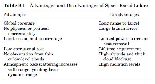
3 SPECIFIC REQUIREMENTS FOR AIRBORNE LIDAR v The primary constraints include limitations on size, mass, power, and receiver aperture, and the ability to operate in an environment with high- and lowfrequency vibrations and temperature and cabin pressure variations. v Should be designed and developed to function with limited operator intervention during flight. v To work in an eye-safe mode when flying over populated areas or in the vicinity of other aircraft.
 GTE: Biosphere/Atmosphere")

4 Airborne lidar measurements of aerosols NASA s Global Tropospheric Experiment (GTE) GTE: Biosphere/Atmosphere Exchange: ABLE-Expeditions study of aerosols from biomass burning GTE Long Range Transport: TRACE-A and PEM-Expeditions Trace gases

5 NASA s Global Tropospheric Experiment (GTE)
6 NASA/GSFS Large Aperture Scanning Airborne Lidar (LASAL) A nadir viewing, scanning Nd:YAG-based lidar, The system operates at a wavelength of 1064 nm and includes a large (36 x 25 inch) mirror, having two axes of motion. capable of rendering a three-dimensional structure of the convective boundary layer and deriving optical thickness over large areas.


7 Airborne lidar measurements of wind Wind Infrared Doppler Lidar (WIND)
8

9

10

11 Airborne DIAL system NASA Langley s airborne UV DIAL system LASE (Lidar Atmospheric Sensing Experiment)
12 Airborne DIAL system

13 NASA Langley s airborne UV DIAL system

14 Airborne RESONANCE FLUORESCENCE LIDAR The University of Illinois Na airborne lidar flown in these campaigns. Hawaiian Airglow-90 (ALOHA-90) Campaign, 1990 ALOHA-93, 1993
15 NASA/GSFC and Langley s Airborne Raman Ozone, Aerosol, and Temperature Lidar (AROTEL) AROTEL has four primary data products: vertical profile of ozone between km vertical profile of temperature from 13 km to ~60 km vertical profile of aerosol scattering aerosol depolarization at 532 nm The transmitter in the AROTEL instrument comprises two different lasers: a XeCl excimer laser, transmitting 308 nm; and a Nd-YAG laser transmitting at 1064, 532, and 355 nm.
16 Lecture 13.2: Space-based lidar
17 Introduction v Technical requirements for space lidar are more demanding than for ground-based or airborne systems. The range to a target within the atmosphere is much larger, with orbital altitudes generally falling in the range of 250 to 700 km, so that R 2 losses are much larger. To increased lidar system photon sensitivity, use higher laser pulse energy and pulse repetition frequency (PRF), larger receiver collection area. However, satellite allocations for electrical power, instrument mass, telemetry, thermal control, etc. are limited. Design of a lidar to be operated on a satellite involves careful balancing of many different constraints. v Must be specially designed to survive the mechanical vibration loads of launch and operate in the vacuum of space v Must be designed to be highly reliable because they must operate without the need for repair or adjustment.
18
19 Technology development for Spacebased lidar missions v The Laser Risk Reduction and Active Optical Remote Sensing Programs v Lidar Technologies for Space Missions Laser Lidar Telescope Detector
20 The Laser Risk Reduction and Active Optical Remote Sensing Programs v Laser Risk Reduction Program (LRRP) was initiated by NASA in 2002 to develop technologies that ensure the successful development of the broad range of lidar missions envisioned by NASA. v Three key recommendations have been made by the LRRP team to advance the space laser technology developing two laser transmitters to provide the primary wavelengths for carrying out six priority measurements for Earth sciences, and chemical and biological agent detection for civilian and warfare applications. (Nd:YAG/YLF laser at 1.06mm and Ho:Tm:YLF/LuLiF laser at 2.05 mm) develop space-qualified laser diode arrays (LDAs) develop eye-safe spacebased solid-state laser transmitters for multiple lidar applications.
21 Lidar Technologies for Space Missions v Laser laser system ruggedness Crossed-Porro laser resonator designs Use as few optical components as possible Good mechanical and thermal design long lifetime operation. Operate all optical components at appropriately derated levels. Design the space laser with enough redundancy.
22 Lidar Technologies for Space Missions v Lidar Telescope high rigidity and long-term stability vs. fabrication cost and mass Fabrication of carbon/silicon carbide (C/SiC) mirrors Using metal alloy shells (next generation of space telescope). v Detector considerably higher sensitivity


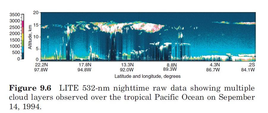
23 Space-based lidar for observations of aerosols and clouds The Lidar In-space Technology Experiment (LITE) flew on the Space Shuttle STS-64 mission in September 1994 as a proof-of-concept demonstration

24
25 ICESat (aka: Laser Altimetry Mision) The Ice, Cloud, and Elevation Satellite v Geoscience Laser Altimeter System (GLAS) - sole instrument v Combinination surface lidar with dual wavelength cloud and aerosol lidar v Launched Jan 12, 2003 Jan 15, 2003 Earth pointing v Measures ice sheet elevations changes in elevation through time height profiles of clouds and aerosols land elevations vegetation cover approximate sea thickness. Images and info from
26 ICESat (aka: Laser Altimetry Mision) The Ice, Cloud, and Elevation Satellite v First laser-ranging instrument for continuous global observations of Earth v Mission data will be distributed and archived by the National Snow and Ice Data Center v More detailed info ICESat FACT SHEET (.pdf) ICESat BROCHURE (.pdf) ICESat LITHO (.pdf) Environmental Assessment for ICESat (.pdf) National Environmental Policy Act (.pdf) Images and info from

 Environmental Assessment for ICESat (.pdf) National Environmental Policy Act (.")
27 ICESat (aka: Laser Altimetry Mision) The Ice, Cloud, and Elevation Satellite v v More detailed info ICESat FACT SHEET (.pdf) ICESat BROCHURE (.pdf) ICESat LITHO (.pdf) Environmental Assessment for ICESat (.pdf) National Environmental Policy Act (.pdf) Images and info from

28 The Ice, Cloud, and land Elevation Satellite-2 (ICESat-2) is the 2nd-generation of the orbiting laser altimeter ICESat scheduled for launch in late 2015 ICESat-2 ICESat_2.ppt


29 CALIPSO: Lidar on Satellite CALIPSO was Lunched in CALIPSO.ppt CALIPSO_summary.pdf
CLASSIFICATION OF NONPHOTOGRAPHIC REMOTE SENSORS
 CLASSIFICATION OF NONPHOTOGRAPHIC REMOTE SENSORS PASSIVE ACTIVE DIGITAL CAMERA THERMAL (e.g. TIMS) VIDEO CAMERA MULTI- SPECTRAL SCANNERS VISIBLE & NIR MICROWAVE HYPERSPECTRAL (e.g. AVIRIS) SLAR Real Aperture
Status of MOLI development MOLI (Multi-footprint Observation Lidar and Imager)
") Status of MOLI development MOLI (Multi-footprint Observation Lidar and Imager) Tadashi IMAI, Daisuke SAKAIZAWA, Jumpei MUROOKA, Rei Mitsuhashi and Toshiyoshi KIMURA JAXA 0 Outline of This Presentation
Status of MOLI development MOLI (Multi-footprint Observation Lidar and Imager) Tadashi IMAI, Daisuke SAKAIZAWA, Jumpei MUROOKA, Rei Mitsuhashi and Toshiyoshi KIMURA JAXA 0 Outline of This Presentation
Learning Objectives LIGHT DETECTION AND RANGING. Sensing. Blacksburg, VA July 24 th 30 th, 2010 LiDAR: Mapping the world in 3-D Page 1
 LiDAR: Mapping the world in 3-D Val Thomas Department of Forest Resources & Environmental Conservation July 29, 2010 Learning Objectives Part 1: Lidar theory What is lidar? How does lidar work? What are
Dennis L. Hlavka* and Stephen P. Palm Science Systems and Applications, Inc NASA/Goddard Space Flight Center, Greenbelt, Maryland
 P1.13 COLUMN OPTICAL DEPTH RETRIEVAL USING SURFACE REFLECTIVITY FROM GLAS Dennis L. Hlavka* and Stephen P. Palm Science Systems and Applications, Inc NASA/Goddard Space Flight Center, Greenbelt, Maryland
LIDAR an Introduction and Overview
 LIDAR an Introduction and Overview Rooster Rock State Park & Crown Point. Oregon DOGAMI Lidar Project Presented by Keith Marcoe GEOG581, Fall 2007. Portland State University. Light Detection And Ranging
Navigation for Future Space Exploration Missions Based on Imaging LiDAR Technologies. Alexandre Pollini Amsterdam,
 Navigation for Future Space Exploration Missions Based on Imaging LiDAR Technologies Alexandre Pollini Amsterdam, 12.11.2013 Presentation outline The needs: missions scenario Current benchmark in space
Lecture 24. Lidar Simulation
 Lecture 24. Lidar Simulation q Introduction q Lidar Modeling via Lidar Simulation & Error Analysis q Functions of Lidar Simulation and Error Analysis q How to Build up Lidar Simulation? q Range-resolved
Claus Weitkamp Editor. Lidar. Range-Resolved Optical Remote Sensing of the Atmosphere. Foreword by Herbert Walther. With 162 Ulustrations.
 Claus Weitkamp Editor Lidar Range-Resolved Optical Remote Sensing of the Atmosphere Foreword by Herbert Walther With 162 Ulustrations 4Q Springer Contents Foreword Preface List of Contributors v vii xix
Airborne Laser Scanning: Remote Sensing with LiDAR
 Airborne Laser Scanning: Remote Sensing with LiDAR ALS / LIDAR OUTLINE Laser remote sensing background Basic components of an ALS/LIDAR system Two distinct families of ALS systems Waveform Discrete Return
About LIDAR Data. What Are LIDAR Data? How LIDAR Data Are Collected
 1 of 6 10/7/2006 3:24 PM Project Overview Data Description GIS Tutorials Applications Coastal County Maps Data Tools Data Sets & Metadata Other Links About this CD-ROM Partners About LIDAR Data What Are
Lecture 09. Lidar Simulation and Error Analysis Overview (1)
") Lecture 09. Lidar Simulation and Error Analysis Overview (1) Introduction Lidar Modeling via Lidar Simulation & Error Analysis Functions of Lidar Simulation and Error Analysis How to Build up Lidar Simulation?
Lecture 09. Lidar Simulation and Error Analysis Overview (1) Introduction Lidar Modeling via Lidar Simulation & Error Analysis Functions of Lidar Simulation and Error Analysis How to Build up Lidar Simulation?
GeoTASO Project Summary and Relevance. Jim Leitch Ball Aerospace
 GeoTASO Project Summary and Relevance Jim Leitch Ball Aerospace jleitch@ball.com 303-939-5280 4/23/2013 Sensor Concept Overview Airborne nadir-viewing wide-swath imaging spectrometer Two channel spectrometer
DELIVERABLE 2 SPECIALIZED NOVEL SOFTWARE FOR THE ACQUISITION AND ANALYSIS OF 6 DIFFERENT LIDAR SIGNALS IN REAL TIME
 DELIVERABLE 2 SPECIALIZED NOVEL SOFTWARE FOR THE ACQUISITION AND ANALYSIS OF 6 DIFFERENT LIDAR SIGNALS IN REAL TIME Project Title : Development of a 6-wavelength LIDAR system for the retrieval of the microphysical
Leica - Airborne Digital Sensors (ADS80, ALS60) Update / News in the context of Remote Sensing applications
 Update / News in the context of Remote Sensing applications") Luzern, Switzerland, acquired with GSD=5 cm, 2008. Leica - Airborne Digital Sensors (ADS80, ALS60) Update / News in the context of Remote Sensing applications Arthur Rohrbach, Sensor Sales Dir Europe,
Luzern, Switzerland, acquired with GSD=5 cm, 2008. Leica - Airborne Digital Sensors (ADS80, ALS60) Update / News in the context of Remote Sensing applications Arthur Rohrbach, Sensor Sales Dir Europe,
CALIPSO Version 3 Data Products: Additions and Improvements
 CALIPSO Version 3 Data Products: Additions and Improvements Dave Winker and the CALIPSO team CALIPSO/CloudSat Science Team Meeting 28-31 July, Madison, WI 1 Version 3 Status Version 3 algorithms now used
CARBON NANOTUBE FLAT PLATE BLACKBODY CALIBRATOR. John C. Fleming
 CARBON NANOTUBE FLAT PLATE BLACKBODY CALIBRATOR John C. Fleming Ball Aerospace, jfleming@ball.com Sandra Collins, Beth Kelsic, Nathan Schwartz, David Osterman, Bevan Staple Ball Aerospace, scollins@ball.com
NEXTMap World 10 Digital Elevation Model
 NEXTMap Digital Elevation Model Intermap Technologies, Inc. 8310 South Valley Highway, Suite 400 Englewood, CO 80112 10012015 NEXTMap (top) provides an improvement in vertical accuracy and brings out greater
VALIDATION OF A NEW 30 METER GROUND SAMPLED GLOBAL DEM USING ICESAT LIDARA ELEVATION REFERENCE DATA
 VALIDATION OF A NEW 30 METER GROUND SAMPLED GLOBAL DEM USING ICESAT LIDARA ELEVATION REFERENCE DATA M. Lorraine Tighe Director, Geospatial Solutions Intermap Session: Photogrammetry & Image Processing
Spectral imagers for nanosatellites
 VTT TECHNICAL RESEARCH CENTRE OF FINLAND LTD Spectral imagers for nanosatellites Finnish Satellite Workshop 2018 Antti Näsilä VTT Microspectrometers Fabry-Perot (FPI) technology for miniaturizing optical
NEXTMap World 30 Digital Surface Model
 NEXTMap World 30 Digital Surface Model Intermap Technologies, Inc. 8310 South Valley Highway, Suite 400 Englewood, CO 80112 083013v3 NEXTMap World 30 (top) provides an improvement in vertical accuracy
Leica ALS70. Airborne Laser Scanners Performance for diverse Applications
 Leica ALS70 Airborne Laser Scanners Performance for diverse Applications Three Models, One Result. Highest Productivity in all Applications. Imagine an affordable 500 khz pulse rate city-mapping LIDAR
ENY-C2005 Geoinformation in Environmental Modeling Lecture 4b: Laser scanning
 1 ENY-C2005 Geoinformation in Environmental Modeling Lecture 4b: Laser scanning Petri Rönnholm Aalto University 2 Learning objectives To recognize applications of laser scanning To understand principles
Lecture 03. Fundamentals of Lidar Remote Sensing (1)
") Lecture 03. Fundamentals of Lidar Remote Sensing (1) q Introduction q History from searchlight to modern lidar q Various modern lidars q Determination of Altitude and Range q Summary and Questions 1 Introduction:
Lecture 03. Fundamentals of Lidar Remote Sensing (1) q Introduction q History from searchlight to modern lidar q Various modern lidars q Determination of Altitude and Range q Summary and Questions 1 Introduction:
Airborne LiDAR Data Acquisition for Forestry Applications. Mischa Hey WSI (Corvallis, OR)
") Airborne LiDAR Data Acquisition for Forestry Applications Mischa Hey WSI (Corvallis, OR) WSI Services Corvallis, OR Airborne Mapping: Light Detection and Ranging (LiDAR) Thermal Infrared Imagery 4-Band
Airborne LiDAR Data Acquisition for Forestry Applications Mischa Hey WSI (Corvallis, OR) WSI Services Corvallis, OR Airborne Mapping: Light Detection and Ranging (LiDAR) Thermal Infrared Imagery 4-Band
Laser Beacon Tracking for High-Accuracy Attitude Determination
 Laser Beacon Tracking for High-Accuracy Attitude Determination Tam Nguyen Massachusetts Institute of Technology 29 th AIAA/USU Conference on Small Satellites SSC15-VIII-2 08/12/2015 Outline Motivation
LiDAR & Orthophoto Data Report
 LiDAR & Orthophoto Data Report Tofino Flood Plain Mapping Data collected and prepared for: District of Tofino, BC 121 3 rd Street Tofino, BC V0R 2Z0 Eagle Mapping Ltd. #201 2071 Kingsway Ave Port Coquitlam,
Interactive comment on Quantification and mitigation of the impact of scene inhomogeneity on Sentinel-4 UVN UV-VIS retrievals by S. Noël et al.
 Atmos. Meas. Tech. Discuss., www.atmos-meas-tech-discuss.net/5/c741/2012/ Author(s) 2012. This work is distributed under the Creative Commons Attribute 3.0 License. Atmospheric Measurement Techniques Discussions
Interactive comment on Quantification and mitigation of the impact of scene inhomogeneity on Sentinel-4 UVN UV-VIS retrievals by S. Noël et al.
 Atmos. Meas. Tech. Discuss., 5, C741 C750, 2012 www.atmos-meas-tech-discuss.net/5/c741/2012/ Author(s) 2012. This work is distributed under the Creative Commons Attribute 3.0 License. Atmospheric Measurement
Light Detection and Ranging (LiDAR)
") Light Detection and Ranging (LiDAR) http://code.google.com/creative/radiohead/ Types of aerial sensors passive active 1 Active sensors for mapping terrain Radar transmits microwaves in pulses determines
Light Detection and Ranging (LiDAR) http://code.google.com/creative/radiohead/ Types of aerial sensors passive active 1 Active sensors for mapping terrain Radar transmits microwaves in pulses determines
Assessing the performance of m footprint waveform lidar data collected in ICESat data corridors in Greenland
 GEOPHYSICAL RESEARCH LETTERS, VOL. 35,, doi:10.1029/2008gl035774, 2008 Assessing the performance of 20 25 m footprint waveform lidar data collected in ICESat data corridors in Greenland M. A. Hofton, 1
Your Company Logo Here. Flying High-Performance FPGAs on Satellites: Two Case Studies
 Your Company Logo Here Flying High-Performance FPGAs on Satellites: Two Case Studies Introduction Often when considering flying a FPGA or other high-performance device the first thoughts might be how will
Using LiDAR for Classification and
 Using LiDAR for Classification and Recognition of Particulate Matter in the Atmosphere M. Elbakary, K. Iftekharuddin, and K. AFRIFA ECE Dept., Old Dominion University, Norfolk, VA Outline Goals of the
MHS Instrument Pre-Launch Characteristics
 MHS Instrument Pre-Launch Characteristics Jörg Ackermann, EUMETSAT, October 2017 The main objective of satellite instruments pre-launch characterisation is to ensure that the observed instrument performance
LIDAR MAPPING FACT SHEET
 1. LIDAR THEORY What is lidar? Lidar is an acronym for light detection and ranging. In the mapping industry, this term is used to describe an airborne laser profiling system that produces location and
Dr. Larry J. Paxton Johns Hopkins University Applied Physics Laboratory Laurel, MD (301) (301) fax
 (301) fax") Dr. Larry J. Paxton Johns Hopkins University Applied Physics Laboratory Laurel, MD 20723 (301) 953-6871 (301) 953-6670 fax Understand the instrument. Be able to convert measured counts/pixel on-orbit into
Dr. Larry J. Paxton Johns Hopkins University Applied Physics Laboratory Laurel, MD 20723 (301) 953-6871 (301) 953-6670 fax Understand the instrument. Be able to convert measured counts/pixel on-orbit into
Hyperspectral Imaging Lidar: Forest canopy heights and gaps for modelling the global carbon cycle
 Lidar: Forest canopy heights and gaps for modelling the global carbon cycle Jan-Peter Muller Mullard Space Sciences Laboratory University College London jpm@mssl.ucl.ac.uk Overview/Team Mathematical model
Lecture 05. First Example: A Real Lidar
 Lecture 05. First Example: A Real Lidar Brief review of lidar basics K Doppler lidar system architecture K lidar signal estimate from lidar equation Comparison of estimate to reality Summary Review of
A Cryogenic Heat Transport System for Space-Borne Gimbaled Instruments
 A Cryogenic Heat Transport System for Space-Borne Gimbaled Instruments M.V. Zagarola 1, J.K. Sanders 1, and C.S. Kirkconnell 2 1 Creare Inc., Hanover, NH 2 Raytheon Space & Airborne Systems, El Segundo,
Evaluation of Satellite Ocean Color Data Using SIMBADA Radiometers
 Evaluation of Satellite Ocean Color Data Using SIMBADA Radiometers Robert Frouin Scripps Institution of Oceanography, la Jolla, California OCR-VC Workshop, 21 October 2010, Ispra, Italy The SIMBADA Project
TELEDYNE GEOSPATIAL SOLUTIONS
 GEOSPATIAL SOLUTIONS THE CONTENTS TELEDYNE GEOSPATIAL SOLUTIONS Capability Overview... 4 Hosted Payloads... 6 Payload Operations as a Service... 8 TCloud Data Management... 10 Imagery Sales... 12 About
Infrared Scene Simulation for Chemical Standoff Detection System Evaluation
 Infrared Scene Simulation for Chemical Standoff Detection System Evaluation Peter Mantica, Chris Lietzke, Jer Zimmermann ITT Industries, Advanced Engineering and Sciences Division Fort Wayne, Indiana Fran
An Introduction to Lidar & Forestry May 2013
 An Introduction to Lidar & Forestry May 2013 Introduction to Lidar & Forestry Lidar technology Derivatives from point clouds Applied to forestry Publish & Share Futures Lidar Light Detection And Ranging
Using Python with Smoke and JWST Mirrors. Warren Hack, Perry Greenfield, Babak Saif, Bente Eegholm Space Telescope Science Institute
 Using Python with Smoke and JWST Mirrors Warren Hack, Perry Greenfield, Babak Saif, Bente Eegholm Space Telescope Science Institute The James Webb Space Telescope (JWST) will be the next NASA Great Observatory
SIMULATED LIDAR WAVEFORMS FOR THE ANALYSIS OF LIGHT PROPAGATION THROUGH A TREE CANOPY
 SIMULATED LIDAR WAVEFORMS FOR THE ANALYSIS OF LIGHT PROPAGATION THROUGH A TREE CANOPY Angela M. Kim and Richard C. Olsen Remote Sensing Center Naval Postgraduate School 1 University Circle Monterey, CA
Improvements to Ozone Mapping Profiler Suite (OMPS) Sensor Data Record (SDR)
 Sensor Data Record (SDR)") Improvements to Ozone Mapping Profiler Suite (OMPS) Sensor Data Record (SDR) *C. Pan 1, F. Weng 2, T. Beck 2 and S. Ding 3 * 1 ESSIC, University of Maryland, College Park, MD 20740; 2 NOAA NESDIS/STAR,
Improvements to Ozone Mapping Profiler Suite (OMPS) Sensor Data Record (SDR) *C. Pan 1, F. Weng 2, T. Beck 2 and S. Ding 3 * 1 ESSIC, University of Maryland, College Park, MD 20740; 2 NOAA NESDIS/STAR,
SICON Smart Sensors Role in Integrated System Health Management
 SICON 2005 Smart Sensors Role in Integrated System Health Management Jose M Perotti, Instrumentation Group Lead Command, Monitoring and Control Branch Spaceport Engineering &Technology Directorate, Kennedy
Design and Implementation of Data Models & Instrument Scheduling of Satellites in a Space Based Internet Emulation System
 Design and Implementation of Data Models & Instrument Scheduling of Satellites in a Space Based Internet Emulation System Karthik N Thyagarajan Masters Thesis Defense December 20, 2001 Defense Committee:
Strapdown Inertial Navigation Technology
 Strapdown Inertial Navigation Technology 2nd Edition David Titterton and John Weston The Institution of Engineering and Technology Preface xv 1 Introduction 1 1.1 Navigation 1 1.2 Inertial navigation 2
COMPARISON OF TREE EXTRACTION FROM INTENSITY DROP AND FROM MULTIPLE RETURNS IN ALS DATA
 COMPARISON OF TREE EXTRACTION FROM INTENSITY DROP AND FROM MULTIPLE RETURNS IN ALS DATA C.Örmeci a, S.Cesur b a ITU, Civil Engineering Faculty, 80626 Maslak Istanbul, Turkey ormeci@itu.edu.tr b ITU, Informatics
AGLITE: A Multiwavelength Lidar for Aerosols
 AGLITE: A Multiwavelength Lidar for Aerosols T.D. Wilkerson 1, G.E. Bingham 1, V.V. Zavyalov 1, J. Swasey 1, J.J. Hancock 1, B.G. Crowther 1, S.S. Cornelsen 2, C. Marchant 1, J.N. Cutts 1, D.C. Huish 3,
Jena-Optronik Relative Navigation Sensor Activities
 Jena-Optronik Relative Navigation Sensor Activities ESA AIM Industry Day Jena-Optronik Relative Navigation Sensor Activities ESA AIM Industry Day. Page 1 Space developments from Jena. 1976 1980 1991 1994
Laser Systems.
 Laser Systems www.aselsan.com.tr VIPER Laser Target Designator & Locator Laser Systems VIPER is a compact, lightweight, advanced ground laser target designator and target locator. VIPER can operate at
Multi-Band (Ku, C, Wideband - Satcom, Narrowband Satcom) Telemetry Test System for UAV Application
 Telemetry Test System for UAV Application") Multi-Band (Ku, C, Wideband - Satcom, Narrowband Satcom) Telemetry Test System for UAV Application Murat IMAY Turkish Aerospace Ind, Inc. Ankara, Turkey mimay@tai.com.tr, muratimay@gmail.com ABSTRACT "This
Multi-Band (Ku, C, Wideband - Satcom, Narrowband Satcom) Telemetry Test System for UAV Application Murat IMAY Turkish Aerospace Ind, Inc. Ankara, Turkey mimay@tai.com.tr, muratimay@gmail.com ABSTRACT "This
Improvements to the SHDOM Radiative Transfer Modeling Package
 Improvements to the SHDOM Radiative Transfer Modeling Package K. F. Evans University of Colorado Boulder, Colorado W. J. Wiscombe National Aeronautics and Space Administration Goddard Space Flight Center
N.J.P.L.S. An Introduction to LiDAR Concepts and Applications
 N.J.P.L.S. An Introduction to LiDAR Concepts and Applications Presentation Outline LIDAR Data Capture Advantages of Lidar Technology Basics Intensity and Multiple Returns Lidar Accuracy Airborne Laser
Space Laser Altimetry: Laser Engineering
 Vol. 24, No.12 The Review of Laser Engineering (1285) Laser Review Space Laser Altimetry: Laser Engineering for Multi-Beam Applications Jack L. BUFTON* and J. Bryan BLAIR** (Received October 26, 1996)
Geoscience Laser Altimeter System (GLAS) LASER FOOTPRINT LOCATION (GEOLOCATION) AND SURFACE PROFILES
 LASER FOOTPRINT LOCATION (GEOLOCATION) AND SURFACE PROFILES") Geoscience Laser Altimeter System (GLAS) Algorithm Theoretical Basis Document Version 2.0 LASER FOOTPRINT LOCATION (GEOLOCATION) AND SURFACE PROFILES Prepared by: B. E. Schutz Center for Space Research
Geoscience Laser Altimeter System (GLAS) Algorithm Theoretical Basis Document Version 2.0 LASER FOOTPRINT LOCATION (GEOLOCATION) AND SURFACE PROFILES Prepared by: B. E. Schutz Center for Space Research
Development of automated ultraviolet laser beam profiling system using fluorometric technique
 Development of automated ultraviolet laser beam profiling system using fluorometric technique BB Shrivastava*, NS Benerji, P Bhatnagar, HS Vora a and U Nundy Chemical and Excimer Laser Section a Laser
Remote Sensing Sensor Integration
 Remote Sensing Sensor Integration Erica Tharp LiDAR Supervisor Table of Contents About 3001 International Inc Remote Sensing Platforms Why Sensor Integration? Technical Aspects of Sensor Integration Limitations
LIDAR and Terrain Models: In 3D!
 LIDAR and Terrain Models: In 3D! Stuart.green@teagasc.ie http://www.esri.com/library/whitepapers/pdfs/lidar-analysis-forestry.pdf http://www.csc.noaa.gov/digitalcoast/_/pdf/refinement_of_topographic_lidar_to_create_a_bare_e
ICESATPROCESSOR, AN INTERFACE FOR ICESAT DATA EXTRACTION: APPLICATION GUIDE
 ICESATPROCESSOR, AN INTERFACE FOR ICESAT DATA EXTRACTION: APPLICATION GUIDE September, 2017 Otá vio Augusto Pássáiá Rodrigo C. D. Páivá 1 INTRODUCTION This manual aims to present an application guide for
Leica ALS80 Airborne Laser Scanners Performance for every Application
 Leica ALS80 Airborne Laser Scanners Performance for every Application Three Models, One Result. Highest Productivity in all Applications. Imagine an affordable city-mapping LIDAR system with an industry-leading
> OLEODL Workshop > Christopher Schmidt OSIRIS Update and Outlook. Christopher Schmidt Institute of Communications and Navigation
 DLR.de Chart 1 OSIRIS Update and Outlook Christopher Schmidt Institute of Communications and Navigation DLR.de Chart 2 OSIRIS Design Roadmap OSIRISv1: Open-Loop Body Pointing 200 Mbit/s OSIRISv2: Closed-Loop
GEOG 4110/5100 Advanced Remote Sensing Lecture 4
 GEOG 4110/5100 Advanced Remote Sensing Lecture 4 Geometric Distortion Relevant Reading: Richards, Sections 2.11-2.17 Review What factors influence radiometric distortion? What is striping in an image?
Effect of Satellite Formation Architectures and Imaging Modes on Albedo Estimation of major Biomes
 Effect of Satellite Formation Architectures and Imaging Modes on Albedo Estimation of major Biomes Sreeja Nag 1,2, Charles Gatebe 3, David Miller 1,4, Olivier de Weck 1 1 Massachusetts Institute of Technology,
ALS40 Airborne Laser Scanner
 ALS40 Airborne Laser Scanner Airborne LIDAR for Professionals High Performance Laser Scanning Direct Measurement of Ground Surface from the Air The ALS40 Airborne Laser Scanner measures the topography
Diffractive Optics for Moon Topography Mapping
 Diffractive Optics for Moon Topography Mapping John G. Smith a, Luis Ramos-Izquierdo b, Andrew Stockham a, Stan Scott b a MEMS Optical *, Inc., 205 Import Circle, Huntsville, AL, USA 35806 b NASA Goddard
RDT&E BUDGET ITEM JUSTIFICATION SHEET (R-2 Exhibit) February 2003
 February 2003") PE NUMBER: 0602605F PE TITLE: DIRECTED ENERGY TECHNOLOGY BUDGET ACTIVITY RDT&E BUDGET ITEM JUSTIFICATION SHEET (R-2 Exhibit) February 2003 PE NUMBER AND TITLE 02 - Applied Research 0602605F DIRECTED ENERGY
PE NUMBER: 0602605F PE TITLE: DIRECTED ENERGY TECHNOLOGY BUDGET ACTIVITY RDT&E BUDGET ITEM JUSTIFICATION SHEET (R-2 Exhibit) February 2003 PE NUMBER AND TITLE 02 - Applied Research 0602605F DIRECTED ENERGY
REFLIGHT OF THE METRIC CAMERA ON THE ATLAS-1 MISSION. M. Schroeder, R. Statter DFVLR, FR Germany
 REFLIGHT OF THE METRIC CAMERA ON THE ATLAS-1 MISSION M. Schroeder, R. Statter DFVLR, FR Germany Abstract: It is planned to fly the Metric Camera again on a Space Shuttle Flight - the ATLAS-1 Mission in
THE USE OF TERRESTRIAL LASER SCANNING FOR MEASUREMENTS IN SHALLOW-WATER: CORRECTION OF THE 3D COORDINATES OF THE POINT CLOUD
 Photogrammetry and Remote Sensing Published as: Deruyter, G., Vanhaelst, M., Stal, C., Glas, H., De Wulf, A. (2015). The use of terrestrial laser scanning for measurements in shallow-water: correction
University of Texas Center for Space Research. ICESAT/GLAS CSR SCF Release Notes for Orbit and Attitude Determination
 University of Texas Center for Space Research ICESAT/GLAS CSR SCF Notes for Orbit and Attitude Determination Charles Webb Tim Urban Bob Schutz Version 1.0 August 2006 CSR SCF Notes for Orbit and Attitude
Photonic Technologies for LiDAR in Autonomous/ADAS. Jake Li (Market Specialist SiPM & Automotive) Hamamatsu Corporation
 Hamamatsu Corporation") Photonic Technologies for LiDAR in Autonomous/ADAS Jake Li (Market Specialist SiPM & Automotive) 03-2018 Hamamatsu Corporation Outline of Presentation 1. Introduction to Hamamatsu 2. Autonomous Levels
Photonic Technologies for LiDAR in Autonomous/ADAS Jake Li (Market Specialist SiPM & Automotive) 03-2018 Hamamatsu Corporation Outline of Presentation 1. Introduction to Hamamatsu 2. Autonomous Levels
Strapdown Inertial Navigation Technology, Second Edition D. H. Titterton J. L. Weston
 Strapdown Inertial Navigation Technology, Second Edition D. H. Titterton J. L. Weston NavtechGPS Part #1147 Progress in Astronautics and Aeronautics Series, 207 Published by AIAA, 2004, Revised, 2nd Edition,
University of Texas Center for Space Research ICESAT/GLAS Document: CSR SCF Release Notes for Orbit and Attitude Determination
 University of Texas Center for Space Research ICESAT/GLAS Document: CSR SCF Notes for Orbit and Attitude Determination Tim Urban Sungkoo Bae Hyung-Jin Rim Charles Webb Sungpil Yoon Bob Schutz Version 3.0
Revision History. Applicable Documents
 Revision History Version Date Revision History Remarks 1.0 2011.11-1.1 2013.1 Update of the processing algorithm of CAI Level 3 NDVI, which yields the NDVI product Ver. 01.00. The major updates of this
RangePRO Model L-GM20 Laser Rangefinder Module
 TABLE OF CONTENTS Chapter Page 1 DESCRIPTION 1-1 2 S 2-1 2.1 System Performance 2-1 2.2 Communications 2-3 2.3 Physical Characteristics 2-3 2.4 Electrical Requirements 2-3 2.5 Environmental 2-4 2.6 Connector/Pin
COOL-COVERINGS. André Santos, The Netherlands Copyright Active Space Technologies
 COOL-COVERINGS André Santos, The Netherlands 21-03-2012 Copyright Active Space Technologies 2004-2011 Young and competent company Started in 2007 in Germany, in 2004 in Portugal Role Support scientific
Quinnipiac Post Flight Aerial Acquisition Report
 Quinnipiac Post Flight Aerial Acquisition Report August 2011 Post-Flight Aerial Acquisition and Calibration Report FEMA REGION 1 Quinnipiac Watershed, Connecticut, Massachusesetts FEDERAL EMERGENCY MANAGEMENT
EXTRACTING SURFACE FEATURES OF THE NUECES RIVER DELTA USING LIDAR POINTS INTRODUCTION
 EXTRACTING SURFACE FEATURES OF THE NUECES RIVER DELTA USING LIDAR POINTS Lihong Su, Post-Doctoral Research Associate James Gibeaut, Associate Research Professor Harte Research Institute for Gulf of Mexico
Critical Aspects when using Total Stations and Laser Scanners for Geotechnical Monitoring
 Critical Aspects when using Total Stations and Laser Scanners for Geotechnical Monitoring Lienhart, W. Institute of Engineering Geodesy and Measurement Systems, Graz University of Technology, Austria Abstract
Development of Portable and Mobile Aerosol Lidars
 Development of Portable and Mobile Aerosol Lidars Zhongmin Zhu National Engineering Research Center for Multimedia Software Wuhan University Wuhan, Hubei, China zzmwh@sohu.com Wei Gong State Key Laboratory
A Surrogate Time Series Model for the Kp Geomagnetic Index
 AEROSPACE REPORT NO. TOR-2013-00515 A Surrogate Time Series Model for the Kp Geomagnetic Index August 20, 2013 T. Paul O Brien Space Science Applications Laboratory Physical Sciences Laboratories Prepared
TES Algorithm Status. Helen Worden
 TES Algorithm Status Helen Worden helen.m.worden@jpl.nasa.gov Outline TES Instrument System Testing Algorithm updates One Day Test (ODT) 2 TES System Testing TV3-TV19: Interferometer-only thermal vacuum
Update on Pre-Cursor Calibration Analysis of Sentinel 2. Dennis Helder Nischal Mishra Larry Leigh Dave Aaron
 Update on Pre-Cursor Calibration Analysis of Sentinel 2 Dennis Helder Nischal Mishra Larry Leigh Dave Aaron Background The value of Sentinel-2 data, to the Landsat world, will be entirely dependent on
Overview of the Trimble TX5 Laser Scanner
 Overview of the Trimble TX5 Laser Scanner Trimble TX5 Revolutionary and versatile scanning solution Compact / Lightweight Efficient Economical Ease of Use Small and Compact Smallest and most compact 3D
The University of Wisconsin Arctic High-Spectral Resolution Lidar: General Information and Data Examples
 The University of Wisconsin Arctic High-Spectral Resolution Lidar: General Information and Data Examples Gijs de Boer, Edwin Eloranta The University of Wisconsin Madison, Madison, WI USA 1. Introduction
Breakout session: Active Remote Sensing for Ocean Colour
 Breakout session: Active Remote Sensing for Ocean Colour Jamet, C. Laboratoire d Océanologie et de Géosciences, Wimereux, France Churnside, J. NOAA, Boulder, USA Hostetler, C. NASA, Langley, USA Passive
SF10 SF10. Features: The SF10 laser altimeter is ideal for automated landings and precision hovering.
 The is a compact, lightweight laser altimeter for above-groundlevel altitude measurement from small fixed wing or multi-rotor craft. The laser altimeter is ideal for automated landings and precision hovering.
Ground LiDAR fuel measurements of the Prescribed Fire Combustion and Atmospheric Dynamics Research Experiment
 Ground LiDAR fuel measurements of the Prescribed Fire Combustion and Atmospheric Dynamics Research Experiment Eric Rowell, Erik Apland and Carl Seielstad IAWF 4 th Fire Behavior and Fuels Conference, Raleigh,
Earth observation in implementing Sendai Framework for Disaster Risk Reduction: UN-SPIDER Efforts
 UN-SPIDER Conference, Beijing, 14-16 September 2015 Earth observation in implementing Sendai Framework for Disaster Risk Reduction: 2015-2030 UN-SPIDER Efforts Shirish Ravan Head, UN-SPIDER Beijing Office
Snow cover change detection with laser scanning range and brightness measurements
 Snow cover change detection with laser scanning range and brightness measurements Sanna Kaasalainen, Harri Kaartinen, Antero Kukko, Henri Niittymäki Department of Remote Sensing and Photogrammetry 5th
RIEGL LMS-Q780. The Versatile, High Altitude Airborne LIDAR Sensor
 RIEGL LMS-Q780 4700m 400kHz The full waveform airborne laser scanner offers great versatility, accuracy, and data quality. The scanner enables you to successfully deliver your projects with industry leading
GEOG 4110/5100 Advanced Remote Sensing Lecture 2
 GEOG 4110/5100 Advanced Remote Sensing Lecture 2 Data Quality Radiometric Distortion Radiometric Error Correction Relevant reading: Richards, sections 2.1 2.8; 2.10.1 2.10.3 Data Quality/Resolution Spatial
Lecture 04. Fundamentals of Lidar Remote Sensing (2)
") Lecture 04. Fundamentals of Lidar Remote Sensing (2) Lidar Equation Introduction Physical Picture of Lidar Equation Fundamental Lidar Equation Different Forms of Lidar Equation Illustration of Lidar Equation
Lecture 04. Fundamentals of Lidar Remote Sensing (2) Lidar Equation Introduction Physical Picture of Lidar Equation Fundamental Lidar Equation Different Forms of Lidar Equation Illustration of Lidar Equation
UAS based laser scanning for forest inventory and precision farming
 UAS based laser scanning for forest inventory and precision farming M. Pfennigbauer, U. Riegl, P. Rieger, P. Amon RIEGL Laser Measurement Systems GmbH, 3580 Horn, Austria Email: mpfennigbauer@riegl.com,
Terrestrial GPS setup Fundamentals of Airborne LiDAR Systems, Collection and Calibration. JAMIE YOUNG Senior Manager LiDAR Solutions
 Terrestrial GPS setup Fundamentals of Airborne LiDAR Systems, Collection and Calibration JAMIE YOUNG Senior Manager LiDAR Solutions Topics Terrestrial GPS reference Planning and Collection Considerations
Seabed Mapping with LiDAR
 Seabed Mapping with LiDAR 2011 Jakarta David Jonas Lt Cdr Rupert Forester-Bennett RN (ret( ret d) October 18 th 2011 Mapping in South East Asia Field Survey Aerial Photography LiDAR Pleased to Introduce
GuideStar II Customer Presentation. February 2012
 GuideStar II Customer Presentation February 2012 Outline Product Overview Description Applications and Features Specifications Technical Details Picomotor Mirror Mounts 8784 Cameras Alignment Layout and
Performance Evaluation of Optech's ALTM 3100: Study on Geo-Referencing Accuracy
 Performance Evaluation of Optech's ALTM 3100: Study on Geo-Referencing Accuracy R. Valerie Ussyshkin, Brent Smith, Artur Fidera, Optech Incorporated BIOGRAPHIES Dr. R. Valerie Ussyshkin obtained a Ph.D.
DRONE MOUNTED NATURAL GAS PIPELINE LEAK DETECTION AND ASSET SAFETY MONITORING
 DRONE MOUNTED NATURAL GAS PIPELINE LEAK DETECTION AND ASSET SAFETY MONITORING KEY WORDS: Asset monitoring, Safety checks, performance analysis, Mid IR range, Laser based Methane detection, unmanned aerial