BIM PROCESS COMPARING NEW BUILD WITH EXISTING ASSETS A VERY QUICK SUMMARY OF THE PROCESS
|
|
|
- Phillip Craig
- 5 years ago
- Views:
Transcription


1 : STEPPING INTO THE FUTURE WITH THE PAST HYBRID MODELLING IN THE BIM PROCESS CARL BROOKES 8 DECEMBER 2017 INTRODUCTION Very quick summary of BIM process Comparing New build with existing assets 3D model and drawing production Different processes and drivers What is Hybrid modelling and BIM? 1. Harmondsworth barn The application of BIM within a heritage context Research project for Historic England covering some relevant topics 2. Kings cross, the lighthouse building BIM contributed to unlocking this project ENGINEERING SIMULATION MY BACKGROUND DEMOLITION WITHOUT UNDERSTANDING BEHAVIOUR Blarnacrag Viaduct, UK THE RISK DEMOLITION WITHOUT BRACING BIM PROCESS COMPARING NEW BUILD WITH EXISTING ASSETS A VERY QUICK SUMMARY OF THE PROCESS DEMOLITION WITH BRACING MODIFICATION TO RESTRAIN MASONRY VIADUCT Reproduced from PAS :2013 Specification for information management for the capital/delivery phase of construction projects using building information modelling 1


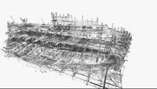


2 NEW BUILD BIM - THE INFORMATION DELIVERY CYCLE EXISTING AND HERITAGE SITES Significant conservation activities Benefits of the newbuild process are being recognised Challenges influencing uptake may relate to CaPex investment expected yet Opex receives greatest benefits Handover of Project Information Model (PIM) becomes the Asset Information Model (AIM) Benefits of BIM are less clear There is no handover asset information model (AIM) Existing information is likely to be a combination of forms, reports, sketches, 2D CAD etc.. Asset database in use, for instance Tribal K2 Some sort of spatial framework/model will need to be produced Ongoing conservation activities Reproduced from PAS :2013 Reproduced from PAS :2014 Specification Specification for information management for the for information management for the operational capital/delivery phase of construction projects phase of assets using building information using building information modelling modelling 3D MODEL AND DRAWING PRODUCTION DIFFERENT PROCESSES AND DRIVERS TOWARDS AUTOMATION ARCHITECTURE, STRUCTURES, MEP, CIVILS, HERITAGE Automated extraction of walls and services for an existing building for use within BIM Typical existing building Revit model Point cloud RGB 3D geometry model Existing traffic gantries Automated extraction of plant within an industrial facility BIM TYPICAL PROJECTS TYPICAL SIMULATION DRIVEN PROJECT POINT CLOUD OF MARY ROSE HULL 3D laser scanning point cloud AS A FEED TO BIM - MESHING DETAILED FORMS Generated with VRMesh Geometry model 2


3 3D MODEL USED BY OTHER DISCIPLINES: MARY ROSE NUMERICAL SIMULATION OF ATMOSPHERE USING CFD POINT CLOUD TO REVIT MODELS POINT CLOUD APPLICATIONS WITHIN HYBRID CAD Conventional process Existing environment scanned, modelled, and new equipment designed and accurately fitted. Reduces risk of expensive snags during construction Better process and very relevant to BIM for heritage Planning tunnel strengthening Use of hybrid environment to avoid modelling HARMONDSWORTH BARN THE APPLICATION OF BIM WITHIN A HERITAGE CONTEXT HARMONDSWORTH BARN & THE IRON BRIDGE Grade I listed Oak framed barn built in 1426 Grade I listed. Spans the River Severn built in 1779 NEW AND TRADITIONAL MEASUREMENT RAPIDLY GROWING DATA ACQUISITION METH0DS CLASSIFICATION OF SURVEY TECHNIQUES AND PROCESSES Generally mass data collection Point clouds Direct or processed Classes based on Range and point cloud density Typical cost (low, medium high) Potential application given 3


 As before, LoD")


4 LEVEL OF DETAIL (HARMONDSWORTH BARN EXAMPLE) LoD based on Potential uses Model tolerance Listing grade Once LoD is established survey class provides options for measurement and data acquisition methods Higher LoDs have object based geometry modelling Similar tables produced for 2D information, archive drawings, sketches, 2D CAD Simple viewers are important too for desktop inspection LEVEL OF DETAIL HARMONDSWORTH BARN EXAMPLE LoD 1 L1 - Ground based photogrammetry LoD 3 M3 - Static tripod supported laser scanners HYBRID ENVIRONMENTS Living bridges of India It is often impossible, within reasonable effort, to represent existing assets with new-building BIM tools. LEVEL OF DETAIL HYBRID ENVIRONMENTS (HARMONDSWORTH BARN EXAMPLE) As before, LoD based on: Potential uses Model tolerance Listing grade Once LoD is established survey class provides options for measurement and data acquisition methods Big advantage no object based geometry modelling of existing fabric Spatial framework for tagging information (links) LoD H1 EXAMPLE POINT CLOUDS WITH LINKS TO SUPPORTING MATERIAL WORKING IN A HYBRID ENVIRONMENT ONLY INTERVENTION AND POSSIBLY INTERPHASE MODELLED AS OBJECTS LoD H3 L3 - Low resolution, medium range handheld laser scanners Shows proposed new beam/tie Software: Software: ReCap, Revit Revit and Recap 4


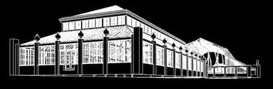
5 COMPARING DATASETS TIME DEPENDANT DATA IS IMPORTANT Useful to track major changes Missing parts and new additions Image compares laser point clouds from 2013 pre-conservation with 2015 postconservation Red indicates parts removed Software: Pointools V8i, CloudCompare, in-house post-processing software COMPARING DATASETS SMALL CHANGES Monitoring small changes Condition monitoring Image compares point clouds from 2013 preconservation photogrammetry with 2015 postconservation KINGS CROSS, THE LIGHTHOUSE BUILDING BIM CONTRIBUTED TO UNLOCKING THIS PROJECT KINGS CROSS, THE LIGHTHOUSE BUILDING KINGS CROSS, THE LIGHTHOUSE BUILDING POINT CLOUDS AND LASER AIDED MODELLING 5

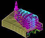

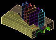


6 POINT CLOUD POINT CLOUD POINT CLOUD STRUCTURAL ANALYSIS BIM EXISTING AND PROPOSED MONITORING COMPARING POINT CLOUDS MAJOR CHANGES 6


, simplified")


 7")
7 KINGS CROSS, THE LIGHTHOUSE BUILDING SIMPLER WAYS OF VIEWING 3D DATA SETS AND BIM 3D PANORAMIC VIEWERS BIM MODELS, BIG DATA SETS AND SIMULATION RESULTS Energy from waste example showing BIM model (top), simplified model, numerical mesh, predicted air temperature results 3D PANORAMIC VIEWERS BIM MODELS, BIG DATA SETS AND SIMULATION RESULTS: RAMVIEW360 RAMView360 link Point cloud, photography and monitoring data RAMView360 is a tool developed by Engineering Simulation Team in Ramboll UK. It allows anyone to view 3D BIM models, big data sets and simulation results all within a web browser LINKED PANORAMIC VIEWERS ENHANCED DRAWING CONTENT LINKED PANORAMIC VIEWERS ENHANCED DRAWING CONTENT RAMView360 link Link to BIM model to provide additional information on phone or tablet (Limited access Beta version) Browser example - link to BIM model to provide additional information on phone or tablet RAMView360 link (Limited access Beta version) 7
The Application of Building Information Modelling (BIM) within a Heritage Science Context
 within a Heritage Science Context") The Application of Building Information Modelling (BIM) within a Heritage Science Context Carl Brookes Discovery, Innovation and Science in the Historic Environment Research Report Series no. 29-2017 Intended
The Application of Building Information Modelling (BIM) within a Heritage Science Context Carl Brookes Discovery, Innovation and Science in the Historic Environment Research Report Series no. 29-2017 Intended
3D Terrestrial Laser Scanner Innovative Applications for 3D Documentation
 3D Terrestrial Laser Scanner Innovative Applications for 3D Documentation Rodney Chaffee Head of Sales, FARO Asia Pacific 3D Laser Scaning Market 2017 2.3 Billion $ 2012 1.3 Billion $ CAGR : > 12% Source:
Laser Scanning. 3D Model is not existing and is required for: studies revamping maintenance HSE integration in another 3D model archiving
 Laser Scanning Laser Scanning Laser scanning is used whenever: 3D Model is not existing and is required for: studies revamping maintenance HSE integration in another 3D model archiving 2 Object acquisition
BIM for infrastructure make easy with Laser Scanner. 17 October Beng Chieh Quah Head of Marketing Asia Pacific
 BIM for infrastructure make easy with Laser Scanner 17 October 2016 Beng Chieh Quah Head of Marketing Asia Pacific who is? founded in 1981 NASDAQ since 1997 Global technology company Offering a range of
Simplicity is the new black: The BLK360 story
 Simplicity is the new black: The BLK360 story Vanda KADLECIKOVA Leica Geosystems Heerbrugg, Switzerland E-mail: vanda.kadlecikova@leica-geosystems.com Abstract Meet the game changer. The new Leica BLK360
OPEN. INTELLIGENT. Laser Scanning Software Solutions
 OPEN. INTELLIGENT. Laser Scanning Software Solutions www.lfm-software.com The Future of Laser Scanning Safe and efficient operation of complex engineering assets, and the efficient management of their
Geospatial Engineering Problems & Solutions Associated With NDP Roads, Tunnelling & Civil Engineering Projects Use of HDS Leica Laser Scanners
 Geospatial Engineering Problems & Solutions Associated With NDP Roads, Tunnelling & Civil Engineering Projects Use of HDS Leica Laser Scanners Laser Scanning Laser Scanning is a method of collecting large
UAVs & IMAGES ACCESSORIES ABOUT GEXCEL
 LIDAR SOFTWARE UAVs & IMAGES MONITORING MOBILE MAPPING ACCESSORIES OTHER ABOUT GEXCEL BUSINESS TEAM LOCATIONS Gexcel offices are located in Italy in two Innovation Centers SALES NETWORK Gexcel s worldwide
Reality Modeling Webinar
 Reality Modeling Webinar Leveraging 3D Reality Meshes for Real-Time Asset Management and Monitoring What is Reality Modeling? Images & video? What is Reality Modeling? Images & video As-built drawings
Example of Monitoring Requirement
 CEGE Department 3DIMPact of Civil, Environmental & Geomatic Engineering (CEGE) 3D Imaging, Metrology, Photogrammetry Applied Coordinate Technologies (3DIMPact) Optical non-contact railway track measurement
DRONE MAPPING FOR CONSTRUCTION
 DRONE MAPPING FOR CONSTRUCTION POWERFUL SOLUTIONS FOR AS-BUILT SURVEYS AND SITE DOCUMENTATION - AUTOMATED FLEXIBLE PROCESSING - REPEATABLE RELIABLE ACCURACY - APPLICABLE RESULTS WE CAPTURE IMAGES FROM
Major Renovation Work in Revit The Survival Guide
 Major Renovation Work in Revit The Survival Guide Jason Boehning Building Content Manager @jasonboehning Join the conversation #AU2016 Class summary Understand the process of using Revit for an existing
Introducing. GeoSLAM. The experts in go anywhere 3D mobile mapping technology. The Company. The Technology. The Applications. Strategic Partnerships
 Introducing GeoSLAM The experts in go anywhere 3D mobile mapping technology The Company The Technology The Applications Strategic Partnerships The Company Multipurpose Presentation Template 2 About Us
Explore Laser Scanning in As-Built Survey. Vijay Chowdhary SE: BIM/CIM
 Explore Laser Scanning in As-Built Survey Vijay Chowdhary SE: BIM/CIM About FARO The world leader in portable 3-D measurement and imaging technology EMEA Headquarters Korntal-Münchingen, Germany APAC Headquarters
BIM & Digital Transformation Scotland Live 2018 Capturing 3D Reality at the push of a button
 BIM & Digital Transformation Scotland Live 2018 Capturing 3D Reality at the push of a button Gary Kelly Country Manager Scotland Leica Geosystems @LeicaScot Capturing 3D Reality at the push of a button
VISUALISATION & 3D MODELLING SERVICES
 VISUALISATION & 3D MODELLING SERVICES 02 VISUALISATION VISUALISATION 3D is more than just an image. We have the ability to visualise and understand your project aspirations. We will deliver a visualisation
Trimble Indoor Mobile Mapping Solution
 Kevin Perkins Applanix Corp. NATIONAL SURVEYING, MAPPING & GEOSPATIAL CONFERENCE - MARCH 13-17, 2017 Trimble Indoor Mobile Mapping Solution Why Indoor Mapping? The need: As-built maps/models of indoor
Version 13 - UK Edition. Revit family creation standards
 Version 13 - UK Edition Revit family creation standards bimstore bible (Version 13) by bimstore Created August 2015 Printed August 2015 copyright bimstore 2015 All rights reserved No part of this publication
Innovation. lidarnews.com. volume 3 issue 5. Points clouds and terrain models support rail project. Structured light scanning for human head modeling
 volume 3 issue 5 LIDAR lidarnews.com SCALABILITY Points clouds and terrain models support rail project EXPRESSION Structured light scanning for human head modeling FLUCTUATION Scanning moving objects using
FARO As-Built for AutoCAD Software Versatile Reality to CAD Solutions
 FARO As-Built for AutoCAD Software Versatile Reality to CAD Solutions FARO As-Built for Autodesk Revit Creating Efficiencies in Scan Data Extraction for BIM FARO As-Built for AutoCAD Software TM Versatile
CAPTURING REALITY AT CENTRE BLOCK
 CAPTURING REALITY AT CENTRE BLOCK C. Boulanger a, C. Ouimet a, N. Yeomans a a Heritage Conservation Services, Public Services and Procurement Canada, 30 Victoria St, Gatineau, Quebec KEY WORDS: Structure
Revit family creation standards
 Revit family creation standards Version 14 - UK Edition bimstore bible 1 bimstore bible (Version 14) by bimstore Created August 2016 copyright bimstore 2016 All rights reserved No part of this publication
Point Clouds to IFC/BrIM Objective:
 Point Clouds to IFC/BrIM Objective: Develop and demonstrate a point cloud data processing solution, which takes a point cloud of a bridge obtained from laser scanning as input, and generates a solid model
Laser Scanning & Creation of 3D Models For BIM and Process Facilities
 Specialised Surveying Solutions Presented to: ICES UAE Region Abu Dhabi November 2009 Land and Engineering Surveying Services 3D Laser Scanning & Modeling Laser Scanning Technology Zoller+Fröhlich Phase
Crossrail: A Case Study in BIM (Draft 26 th July 2013)
") Crossrail: A Case Study in BIM (Draft 26 th July 2013) Crossrail: A Case Study in BIM Malcolm Taylor Crossrail Head of Technical Information 29 th October 2013 Agenda Briefly set the scene What BIM in
Crossrail: A Case Study in BIM (Draft 26 th July 2013) Crossrail: A Case Study in BIM Malcolm Taylor Crossrail Head of Technical Information 29 th October 2013 Agenda Briefly set the scene What BIM in
Industry 4.0 revolutionizing BIM and AEC
 CONFERÊNCIA CONSTRUÇÃO 4.0 O DESAFIO DA DIGITALIZAÇÃO DA CONSTRUÇÃO E A ENGENHARIA CIVIL NO CONTEXTO DA INDÚSTRIA 4.0 Industry 4.0 revolutionizing BIM and AEC Vakis P. Kokorelis Construsoft Portugal 22
Laser Surveys BIM ready models LASER SURVEYS. BIM Ready Models. A guide for our Clients. P a g e 1
 LASER SURVEYS BIM Ready Models A guide for our Clients P a g e 1 Introduction - the purpose of this guide: Survey information for the construction industry has a long-established tradition and is generally
Scan-to-BIM. NEWBIM ApS, Galina Slavova CEO, BIM Specialist
 Scan-to-BIM NEWBIM ApS, Galina Slavova CEO, BIM Specialist Agenda What is Building Information Modeling (BIM) About NEWBIM ApS 3D Laser Scanning Integration Case Study Demonstration Building Information
Real World to Virtual World. With Geomagic Design X
 Real World to Virtual World With Geomagic Design X About OR3D OR3D based in UK with offices in Wrexham (Wales) and Bristol (England) Cover the UK and Internationally UK s largest supplier of Geomagic software
Optimize Your Data Center. Gary Hill VP, Business Development DVL Group, Inc.
 Optimize Your Data Center Gary Hill VP, Business Development DVL Group, Inc. Data Center Age Profile Gartner Group Survey Legacy Data Centers Challenges Under Powered - Room or Racks Inadequate Air Delivery
Draper Aden VIRTUAL CONSTRUCTION DOCUMENT, DESIGN, AND BUILD IN 3D
 VIRTUAL CONSTRUCTION VIRTUAL CONSTRUCTION The design and construction environment has changed. While the goals of completing a project on time, within budget, and at the expected level of quality remain
US foundry Bradken implements optical measuring technology
 Application Note US foundry Bradken implements optical measuring technology Location / country: Tacoma / Washington, USA GOM systems: ATOS Triple Scan, TRITOP GOM software: ATOS Professional Sector: Power
3-D Modeling Implementation
 3-D Modeling Implementation Presented January 31, 2013 Douglas Townes FHWA Resource Center WORKFLOW FOR ELECTRONIC DATA TRANSFER WHEN USING AMG IN CONSTRUCTION Charles Jahren, PhD Iowa State University
 www.lfm-software.com LFM Software Overview Realise the true value of your laser scan data. Outside the EPC environment, Owner Operators are now also recognising the benefits of 3D laser scanning. Laser
Know What You Want: How to Start a Successful Scan-to-BIM Project MARGARITA LEONOVA
 Know What You Want: How to Start a Successful Scan-to-BIM Project MARGARITA LEONOVA Scan-to-BIM Scan the Building Get a Point Cloud Generate Building Information Model Scan-to-BIM Why convert a point cloud
THE COLORED COMPARISON OF THE WALL SCULPTURE WITH 3D LASER SCANNER AND ORTHOPHOTO
 THE COLORED COMPARISON OF THE WALL SCULPTURE WITH 3D LASER SCANNER AND ORTHOPHOTO Hirotoshi KURASHIGE, Jun KATO, Shozo NISHIMURA Creative Department, Keisoku Research Consultant Co, 1-665-1 Fukuda, Higashi-ku,
Virtual and remote inspection methods
 Virtual and remote inspection methods Rasmus Lindeneg Johansen, RLJ@cowi.dk 1 How do we inspect "today"? 2 Inspection "today" Manual inspections From the ground From lift/platform By rope Data was collected
Revit Architecture Syllabus Total duration: 80 hours (Theory 40 Hours + Lab 40 Hours)
") Faculty Start Date End Date No of Students Revit Architecture Syllabus Total duration: 80 hours (Theory 40 Hours + Lab 40 Hours) Introduction About BIM Introduction to Autodesk Revit Architecture Revit
Faculty Start Date End Date No of Students Revit Architecture Syllabus Total duration: 80 hours (Theory 40 Hours + Lab 40 Hours) Introduction About BIM Introduction to Autodesk Revit Architecture Revit
KRISTAPS KLAVA - HEAD OF LASER SCANNING DEPARTMENT AT MERKO 3D LASER SCANNING POSSIBILITIES IN REAL ESTATE
 KRISTAPS KLAVA - HEAD OF LASER SCANNING DEPARTMENT AT MERKO 3D LASER SCANNING POSSIBILITIES IN REAL ESTATE Overview 1. What is laser scanning; 2. Technology; 3. End results of laser scanning; 4. Applications;
Trimble 3D Laser Scanning TRANSFORMING THE WAY THE WORLD WORKS
 Trimble 3D Laser Scanning Speed, Precision and Versatility Complete Solutions for Every Challenge CAPTURE AND DELIVER PRECISE DATA. FASTER. For scanning professionals, speed and precision are critical.
Integrating Laser Scanning and 3D Capture in Shipbuilding
 Integrating Laser Scanning and 3D Capture in Shipbuilding Jen Rizzo, AVEVA Greg Lawes, point3d www.aveva.com About AVEVA The leading supplier of engineering design and information management software solutions
BSI BIM Solutions. Copyright 2016 BSI. All rights reserved.
 BSI BIM Solutions Copyright 2016 BSI. All rights reserved. 1 BSI Group Policy, Engagement National Standards Body Assessment and Certification Compliance support Standards Information Solutions Training
Integrated Field to Finish BIM for Surveyors. Boris Skopljak Market Manager, Trimble Geospatial Office Software
 Integrated Field to Finish BIM for Surveyors Boris Skopljak (boris_skopljak@trimble.com) Market Manager, Trimble Geospatial Office Software Agenda Trimble Introduction BIM relevance in Trimble Trimble
Most as-built information is still manually collected. Today s Design Market
 Agenda 1. Overview of 3D laser scanning 2. HDS 3D Laser scanning applications Leica ScanStation2 True Color Scan 3. Demonstration of HDS & Trueview 4. Questions and Answers The advanced 3D Laser Scanning
Integration of Textural and Material Information Into Existing BIM Using IR Sensing. A research by: Asem Zabin Baha Khalil
 Integration of Textural and Material Information Into Existing BIM Using IR Sensing A research by: Asem Zabin Baha Khalil Asem Zabin Senior BIM Engineer at itech Management Consultancy Master of Science
Artescan, 3D Scanning IPN TecBis, Edif. E Rua Pedro Nunes, Coimbra, Portugal
 1 Displacement and surface pathology monitoring of former Tejo Power Station building by combining terrestrial laser scanning, micro-geodesy, photogrammetry and GIS Adriano OLIVEIRA, João BOAVIDA, Bruno
3D SCANNING SERVICES FOR PUBLIC & PRIVATE CLIENTS
 Services provided include: 3D Scanning of Existing Structures & Equipment 3D Modeling for Current or Future Planning What can be scanned? Any 3-Dimensional Space Industrial Facilities Transshipment and
Oblique aerial imagery in the praxis: applications and challenges
 ISPRS / EuroSDR Workshop on Oblique aerial cameras sensors and data processing Barcelona, 10 October 2017 Oblique aerial imagery in the praxis: applications and challenges Daniela Poli, Kjersti Moe, Klaus
Point Cloud Scoping and Acquisition. Best Practice Guidelines. v1.9
 Point Cloud Scoping and Acquisition Best Practice Guidelines v1.9 Contents Statement of Intent... 3 Table 1: Point Cloud Project Scoping Guide... 4 Table 2: Required Quality Control... 5 Recommended Certification
The Most Comprehensive Solution for Indoor Mapping Applications
 The Most Comprehensive Solution for Indoor Mapping Applications TRIMBLE INDOOR MOBILE MAPPING SOLUTION TRIMBLE INDOOR MOBILE MAPPING SOLUTION (TIMMS): HIGH EFFICIENCY, MAXIMUM FLEXIBILITY, ALL-IN-ONE PACKAGE
Revit MEP. Autodesk Navisworks
 What is BIM? Autodesk BIM is an intelligent model-based process that helps owners and service providers achieve business results by enabling more accurate, accessible, and actionable insight throughout
ADVANCING REALITY MODELING WITH CONTEXTCAPTURE
 ADVANCING REALITY MODELING WITH CONTEXTCAPTURE Knowing the existing conditions of a project is a key asset in any decision process. Governments need to better know their territories, through mapping operations,
Terrestrial Laser Scanning: Applications in Civil Engineering Pauline Miller
 Terrestrial Laser Scanning: Applications in Civil Engineering Pauline Miller School of Civil Engineering & Geosciences Newcastle University Overview Laser scanning overview Research applications geometric
Comparing Aerial Photogrammetry and 3D Laser Scanning Methods for Creating 3D Models of Complex Objects
 Comparing Aerial Photogrammetry and 3D Laser Scanning Methods for Creating 3D Models of Complex Objects A Bentley Systems White Paper Cyril Novel Senior Software Engineer, Bentley Systems Renaud Keriven
Leica High-Definition Surveying Systems. Leica HDS3000. The Industry Standard for High-Definition Surveying
 Leica High-Definition Surveying Systems Leica HDS3000 The Industry Standard for High-Definition Surveying HDS High-Definition Surveying TM : Laser Scanning Redefined High-Definition Surveying, or HDS,
The Leica HDS Family. The Right Tool for the Job HDS3000 HDS2500 HDS4500. Cyclone & CloudWorx. Press the QuickScan button to define the field-of-view.
 HDS2500 High accuracy scanner, ideal for fixed or raised installations when leveled tripod mounting is not practical, or areas with less stringent field-of-view requirements. The Leica HDS Family Time-of-flight
Beyond the Limits: Using Autodesk Revit and Navisworks Manage for Design Collaboration on Large-Scale Projects
 Beyond the Limits: Using Autodesk Revit and Navisworks Manage for Design Collaboration on Large-Scale Projects Joseph Huang MWH Global Luther Lampkin MWH Global SE4259 This class covers best practices
Suite en It Up with Autodesk ReCap
 Chad Studer ADSK Solutions RC3165 Static and mobile laser scanning technologies capture millions of points and provide photorealistic interactive virtual sites known as point clouds. With Autodesk ReCap
Semi-Automatic Techniques for Generating BIM Façade Models of Historic Buildings
 Semi-Automatic Techniques for Generating BIM Façade Models of Historic Buildings C. Dore, M. Murphy School of Surveying & Construction Management Dublin Institute of Technology Bolton Street Campus, Dublin
A selection of our previous clients:
 Survey Solutions Geo-Spatial Survey Solutions Ltd Contact: Tel: Email: Y X Roger Davies 07713 160041 roger.davies@geo-spatial.co.uk www.geo-spatial.co.uk A selection of our previous clients: English Heritage
Virtually Real: Terrestrial Laser Scanning
 Check. They re Chartered. Geomatics Client Guides Virtually Real: Terrestrial Laser Scanning Understanding an evolving survey technology Summary This guide gives you an overview of the technique, some
groupbc.com Introducing BC 7 What s New Highlights
 groupbc.com Introducing BC 7 What s New Highlights Simplicity and Usability Key Features and Benefits include: In BC 7 we ve concentrated on simplicity and usability: cleaner, more flexible interface,
Defence and Security
 Defence and Security 13 HVM Perimeter Security Deployed at Westminster 2 Our Story TSP Projects is an innovative solutions driven company which prides itself on engineering projects and products, tailored
ROAD-SCANNER COMPACT APPLICATION FIELDS MAIN FEATURES
 ROAD-SCANNER COMPACT Mobile Mapping System by GEXCEL & SITECO collaboration A smaller mobile system for asset management and cartography suited for ZOLLER & FRÖHLICH PROFILER 9012 laser scanner. 2 + 3
Building Information Modeling
 Chapter Building Information Modeling 1 Building information modeling (BIM) is an integrated workflow built on coordinated, reliable information about a project from design through construction and into
Revit MEP 2014 Add-in. SysQue
 Revit MEP 2014 Add-in the difference is REAL SysQue June 17, 2013-14:15 Managed manufacturer specific objects and data in BIM Jim Reis, CFO TSI JReis@TSI-Software.com TSI Overview: What We Do the difference
VERSATILE AND EASY-TO-USE 3D LASER SCANNERS
 VERSATILE AND EASY-TO-USE 3D LASER SCANNERS > > A WORLD OF APPLICATIONS Z Corporation, producers of the industry s fastest, easiest-to-use and most versatile 3D scanners, makes 3D scanning ideal for a
Trimble MX2 mobile mapping
 Trimble MX2 mobile mapping user applications Point clouds within your reach The Trimble MX2 is a vehicle-mounted spatial imaging system which combines high resolution laser scanning and panoramic cameras
An Undergraduate Project with Terrestrial Laser Scanner for Purpose of Architectural Survey
 Theory and Application of Laser Scanning ISPRS Summer School 2007 Ljubljana,Slovenia An Undergraduate Project with Terrestrial Laser Scanner for Purpose of Architectural Survey Cemal Özgür KIVILCIM ISPRS
TERRESTRIAL LASER SCANNING AND APPLICATION IN GEODETIC ENGINEERING
 TERRESTRIAL LASER SCANNING AND APPLICATION IN GEODETIC ENGINEERING Marko Pejić U n i ve rs i t y o f B e l g ra d e, Fa c u l t y o f C i v i l E n g i n e e r i n g Mostar, 10.19.2017. TLS method and
ASSETS DATA INVENTORY BASED ON BUILDING INFORMATION MODELLING
 ASSETS DATA INVENTORY BASED ON BUILDING INFORMATION MODELLING Asep Yusup Saptari (Surveying and Cadastre Research Group) Geodesy And Geomatic Earth Science And Engineering Faculty Institut Teknologi Bandung
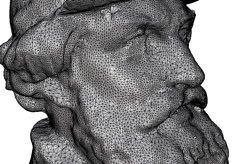
Integrated Projects. Madonna di Pietranico Pompeii insula V1 V I S UA L COMPUTING L A B I ST I - C N R
 Integrated Projects Madonna di Pietranico Pompeii insula V1 V I S UA L COMPUTING L A B I ST I - C N R La Madonna di Pietranico Pietranico s Madonna Terracotta statue, destroyed by an earthquake. We used
Microwave. Infrared. Preprogrammed Chip
 Advanced Technology for Design Mapping and Construction Layout AACE A.A.C.E. Meeting August 5, 2009 Daniel K. Mardock RBF Consulting Survey Manager Registered Land Surveyor Certified Federal Surveyor Arizona
Trimble Connect Overview
 Trimble Connect Overview Trimble Connect reduces costs and improves efficiency for buildings and infrastructure projects. It does this by consolidating and seamlessly exchanging information throughout
Building Information Modeling
 Chapter Building Information Modeling 1 Building information modeling (BIM) is an integrated workflow built on coordinated, reliable information about a project from design through construction and into
TSP Technical Solutions in Partnership
 TSP Technical Solutions in Partnership Discovering our customers needs and delivering the correct solutions: on budget, on time, first time. w: tspprojects.co.uk t: +44(0)1904 454600 Offices in Birmingham,
BEFORE YOU BUY: SEVEN CRITICAL QUESTIONS TO ASK ABOUT LASER SCANNERS. Robert Gardiner
 BEFORE YOU BUY: SEVEN CRITICAL QUESTIONS TO ASK ABOUT LASER SCANNERS Robert Gardiner Table of Contents Introduction... 3 Horizontal and Vertical Angular Accuracies... 4 Movement Tracking... 6 Range Limitations...
2/19/2018. Who are we? Who am I? What is Scanning? How does scanning work? How does scanning work? Scanning for Today s Surveyors
 2/19/2018 Who are we? Scanning for Today s Surveyors Survey, GIS, and Construction dealer Founded in 1988 Employee Owned Headquartered in Bismarck, ND States covered: ND, SD, MN, MT, WY, CO, UT, ID, WA,
Revit Structure. Autodesk Navisworks
 What is BIM? Autodesk BIM is an intelligent model-based process that helps owners and service providers achieve business results by enabling more accurate, accessible, and actionable insight throughout
HP-L-8.9 LASER SCANNER
 PRODUCT BROCHURE HP-L-8.9 LASER SCANNER Cost-effective laser scanning for the ROMER Absolute Arm 2 HP-L-8.9 LASER SCANNER HIGHLIGHTS MAKING LASER SCANNING ACCESSIBLE TO ALL The HP-L-8.9 is an affordable
Comparing Aerial Photogrammetry and 3D Laser Scanning Methods for Creating 3D Models of Complex Objects
 www.bentley.com Comparing Aerial Photogrammetry and 3D Laser Scanning Methods for Creating 3D Models of Complex Objects A Bentley White Paper Cyril Novel Senior Software Engineer, Bentley Systems Renaud
The Processing of Laser Scan Data for the Analysis of Historic Structures in Ireland
 The 7th International Symposium on Virtual Reality, Archaeology and Cultural Heritage VAST (2006) M. Ioannides, D. Arnold, F. Niccolucci, K. Mania (Editors) The Processing of Laser Scan Data for the Analysis
JANUARY 2017 WATER S END. Mobile Mapping. Station to Station. Decided Guidance Indoor application. Implementing BIM. A fixed boundary R E YEARS
 JANUARY 2017 WATER S END Mobile Mapping Station to Station Decided Guidance Indoor application Implementing BIM A fixed boundary R LEB ATING E C 30 YEARS Indoor Mobile Mapping A unique approach to interior
SPAR, ELMF 2013, Amsterdam. Laser Scanning on the UK Highways Agency Network. Hamish Grierson Blom Uk
 SPAR, ELMF 2013, Amsterdam Laser Scanning on the UK Highways Agency Network Hamish Grierson Blom Uk www.blomasa.com www.blom-uk.co.uk Blom UK Part of the Blom Group Blom Group - Europe s largest aerial
Convert Manual Drawings to Digital. Technical drawings manually drawn on paper can be scanned, traced & converted to CAD files.
 Convert Manual Drawings to Digital. Technical drawings manually drawn on paper can be scanned, traced & converted to CAD files. Advantages of CAD: Standardisation of drawing conventions to Bsi & International
Covers Autodesk Advance Steel fundamentals, so you become quickly productive with the software
 Covers Autodesk Advance Steel fundamentals, so you become quickly productive with the software Autodesk Advance Steel 2017 www.autodesk.com new Autodesk Advance Steel users. It is recommended that you
Trimble VISION Positions from Pictures
 Trimble VISION Positions from Pictures This session will cover What Is Trimble VISION? Trimble VISION Portfolio What Do you Need? How Does It Work & How Accurate Is It? Applications Resources Trimble VISION
PLAYBOOK. How Do You Plan to Grow? Evaluating Your Critical Infrastructure Can Help Uncover the Right Strategy
 PLAYBOOK F O R C H A N G E How Do You Plan to Grow? Evaluating Your Critical Infrastructure Can Help Uncover the Right Strategy The world is becoming more digital every day. The demand for feature-rich,
Overview and Agenda. (Green)BIM, Indoor Mobile Mapping - Innovative Ways to Scan Geomatic BIM education
BIM, Indoor Mobile Mapping - Innovative Ways to Scan Geomatic BIM education") CEGE Department - 3DIMPact of Civil, Environmental & Geomatic Engineering (CEGE) 3D Imaging, Metrology, Photogrammetry Applied Coordinate Technologies (3DIMPact) Chadwick GreenBIM Advancing Operational
CEGE Department - 3DIMPact of Civil, Environmental & Geomatic Engineering (CEGE) 3D Imaging, Metrology, Photogrammetry Applied Coordinate Technologies (3DIMPact) Chadwick GreenBIM Advancing Operational
Data, Data, Everywhere. We are now in the Big Data Era.
 Data, Data, Everywhere. We are now in the Big Data Era. CONTENTS Background Big Data What is Generating our Big Data Physical Management of Big Data Optimisation in Data Processing Techniques for Handling
Using Laser Scanning technology and software. Chris Palmer Sales Engineer 28 th April
 Construction Verification Using Laser Scanning technology and software Chris Palmer Sales Engineer 28 th April 2017 1 Contents What is construction verification? How do we measure and check construction
A Sweet Success in Plant Documentation for Michigan Sugar Company
 A Sweet Success in Plant Documentation for Michigan Sugar Company COMPANY LOCATION 3D Imaging Services Flint, MI TOOLS USED Leica ScanStation P40 (solutionshardware-p40.html) Leica Cyclone Software (solutionssoftware-cyclone.html)
With FARO PointSense for Revit. Jörg Braunes Platform Owner Software Chris Palmer Sales Engineer 1
 From Point Clouds to BIM Models With FARO PointSense for Revit Jörg Braunes Platform Owner Software Chris Palmer Sales Engineer 1 Agenda Scan to BIM with Revit PointClouds in Revit Advanced Workflow with
A web based BIM/GIS integration platform on top of open source
 A web based BIM/GIS integration platform on top of open source Sanghee Shin(shshin@gaia3d.com) Seongdo Son(sdson@gaia3d.com) Hakjoon Kim(hjkim@gaia3d.com) Jengdae Cheon(jdcheon@gaia3d.com)
3D Grid Size Optimization of Automatic Space Analysis for Plant Facility Using Point Cloud Data
 33 rd International Symposium on Automation and Robotics in Construction (ISARC 2016) 3D Grid Size Optimization of Automatic Space Analysis for Plant Facility Using Point Cloud Data Gyu seong Choi a, S.W.
Building Information ModelingChapter1:
 Chapter 1 Building Information ModelingChapter1: Building information modeling (BIM) is an integrated workflow built on coordinated, reliable information about a project from design through construction
USE THE 3D LASER SCANNING FOR DOCUMENTATION THE RIGA CATHEDRAL IN LATVIA
 USE THE 3D LASER SCANNING FOR DOCUMENTATION THE RIGA CATHEDRAL IN LATVIA Maris Kalinka, Elina Rutkovska, Department of Geomatic, Riga Technical University, Azenes 16-109, Riga, Latvia, geomatika@geomatika.lv
Leica ScanStation C10 The All-in-One Laser Scanner for Any Application
 The All-in-One Laser Scanner for Any Application Versatility, Productivity, Value Many organizations interested in laser scanning to diversify and/or improve current business have been waiting for a scanner
Constru January 15, 2013
 Use of Modula ar Design and its Relation to Energy Performance and Constru uction Costs January 15, 2013 The data center designerr and user now have a very wide range of modular options available with
Complete Construction Digital Documentation.a record for Life.
 Complete Construction Digital Documentation.a record for Life. PHOTO. VIDEO. WEBCAM. Total Asset Visibility Developed In Vancouver 2013 Operates in 48 Offices around the world Last 3 years have Documented