Adham Alzbiedi. ArcGIS for Server Performance and Scalability: Optimizing GIS Services
|
|
|
- Martin Ross
- 5 years ago
- Views:
Transcription

1 Adham Alzbiedi ArcGIS for Server Performance and Scalability: Optimizing GIS Services
2 WorkShop objectives 1. Describe web GIS implementation patterns 2. Explain how ArcGIS Server shares GIS data and functionality 3. Describe ArcGIS Server implementation options 4. Identify which service property to alter based on a performance problem 5. Alter service properties to improve performance 6. Describe how to monitor service performance using log files


3 Web GIS Desktop Web Device APPS Portal ACCESS SERVICES Server Online content and Services


4 ArcGIS Server and web services ArcGIS Server Mapping Analysis Admin HTTP HTTP


5 Accessing GIS services Map service REST services/service/mapserver SOAP services/service/mapserver KML services/service/mapserver/kmlserver
6 On-your-own-infrastructure implementation GIS server Portal for ArcGIS Web Adaptor Local area network DMZ


7 Hybrid implementation ArcGIS Online GIS server Portal for ArcGIS Web Adaptor Local area network DMZ
8 Demo1 - Installing web adapter and configure it with existing ArcGIS Server Product - Create new connection in ArcCatalog Application - Publish Basemap with Scale dependency
9 Tuning Services - Service Properties. - ArcGIS Server Log.
10 Service Properties. - Service Properties allow you to fine-tune how services run, which can heavily influence performance.
11 Service Properties Pooling Tab. Property Description When to adjust it Minimum number of instances per machine Maximum number of instances per machine The Maximum time a client can use a service Minimum number of instances of the service to create on each node within the cluster Default=1 Maximum number of instances of the service to create on each node within the cluster Default=2 Maximum number of seconds an instance can service a request. Default=600 seconds (10 minutes) Increase if there are frequently more requests than available instances Decrease if there are frequently more available instances than requests. Increase if clients are frequently waiting for an available instance. Decrease for infrequent requests. Increase for requests that may take longer Decrease for services that complete quickly to free system resources.
12 Service Properties Pooling Tab.. The maximum time a client will wait to get a service Maximum number of seconds the framework will wait for a free instance of the service before rejecting a service request. Default = 60 Seconds increase on a busy system. The maximum time an idle instance can be kept running Maximum number of seconds an idle instance of a service must be kept alive before it can be destroyed Default = 180 seconds (30 minutes) Increase if new instances are created frequently. Decrease for infrequently requested services to free system resources.
13 Service Properties.

14 Service Properties.
15 Service Properties

16 Service Properties
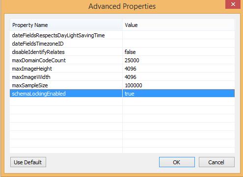
17 Service Properties
18 ArcGIS Server Logs - Troubleshooting workflow - Temporarily elevate the logging level - Interact with the site or/and service (query, pan, zoom, ) - Review the logs and, if necessary, generate additional logging data - Return the logging level to the default setting ( warning ).

19 Log Levels
20 Demo2 - Explore service statistics - Explore ArcGIS Server logs
21 GISTEC Professional Services GISTEC Professional Service offer a wide variety of GIS consulting Advisory and implementation services leverage a range of solutions to enhance knowledge transfer Encourage best practices and provide consulting services for a multitude of GIS application.

22 Why you need Professional Services Ad Hoc GIS Tasks and Services GISTEC-SCP Utilized on the go Application Development Professional Services Cost Effective Consulting Services GISWORX Flexibility to purchase services and training Training & Capacity Building Technical Account Management

23 How the Professional Services works GISTEC Professional Services can be processed online or by calling GISTEC customer service directly. If not utilized the credits can be rolled over to the next year.
24 A large number of employees. The Team Diversified Expertise : Developers, System analysts, Solution Architects Difficult & hard to find in the market : Different number of years starting from 2 to 25 years of GIS expertise Cost Effective: The client cannot recruit such a huge number of employees to perform 1 task Flexibility: Experienced personnel that can be pulled any time whenever required
ArcGIS Enterprise: Advanced Topics in Administration. Thomas Edghill & Moginraj Mohandas
 ArcGIS Enterprise: Advanced Topics in Administration Thomas Edghill & Moginraj Mohandas Outline Overview: Base ArcGIS Enterprise Deployment - Key Components - Administrator Endpoints Advanced Workflows:
Architect your deployment using Chef
 ArcGIS Enterprise Architect your deployment using Chef Cherry Lin and Scott MacDonald ArcGIS Enterprise base deployment Why automate your ArcGIS Enterprise deployment? Efficiency Get up and running faster
ArcGIS Online. The Road Ahead Geoff Mortson
 ArcGIS Online The Road Ahead Geoff Mortson gmortson@esricanada.com ArcGIS Online Easily create and share maps Delivered as intelligent maps Access on virtually any device anyone, anywhere Compliments and
ArcGIS Enterprise: Architecture & Deployment. Anthony Myers
 ArcGIS Enterprise: Architecture & Deployment Anthony Myers 1 2 3 4 5 Web GIS Overview of ArcGIS Enterprise Federation & Hosted Server Deployment Patterns Implementation 1 Web GIS ArcGIS Enabling GIS for
ArcGIS Online: Three-and-a-Half Ways to Create Tile Layers. Eric Anderson & Adam Eversole Esri Support Services
 ArcGIS Online: Three-and-a-Half Ways to Create Tile Layers Eric Anderson & Adam Eversole Esri Support Services Agenda 1. Introduction 2. What is a tile layer 3. How a tile layer works 4. The 3 ½ ways to
Introduction to ArcGIS Server Architecture and Services. Amr Wahba
 Introduction to ArcGIS Server 10.1 - Architecture and Services Amr Wahba awahba@esri.com Agenda Architecture Features Publishing Security Cloud Powerful GIS capabilities Delivered as Web services To help
ArcGIS for Server: Administration and Security. Amr Wahba
 ArcGIS for Server: Administration and Security Amr Wahba awahba@esri.com Agenda ArcGIS Server architecture Distributing and scaling components Implementing security Monitoring server logs Automating server
Building Android Apps Runtime SDK for Android
 Building Android Apps Runtime SDK for Android Dan O Neill & Alan Lucas Introductions What do you do What do we do - Android Development Team - Edinburgh Alan Lucas - https://github.com/alan-edi - Alaska
ArcGIS Server and Portal for ArcGIS An Introduction to Security
 ArcGIS Server and Portal for ArcGIS An Introduction to Security Jeff Smith & Derek Law July 21, 2015 Agenda Strongly Recommend: Knowledge of ArcGIS Server and Portal for ArcGIS Security in the context
Real-Time GIS: Leveraging Stream Services
 Real-Time GIS: Leveraging Stream Services Mark Bramer Senior Technical Analyst Esri Professional Services mbramer@esri.com RJ Sunderman Product Engineer GeoEvent Extension Product Team rsunderman@esri.com
ArcGIS Pro: Effective License Management. Stephanie Wendel Melanie Summers Rob Elkins
 ArcGIS Pro: Effective License Management Stephanie Wendel Melanie Summers Rob Elkins Effective License Management Licensing Model Key Concepts Setting Up and Managing your Organization Grouping Users How
ArcMap: Tips and Tricks
 Esri International User Conference San Diego, California Technical Workshops July 23 27, 2012 ArcMap: Tips and Tricks Miriam Schmidts Jorge Ruiz-Valdepena Agenda Navigating ArcMap Repairing data links
ArcGIS for Server: Security
 DevSummit DC February 11, 2015 Washington, DC Michael Sarhan Esri msarhan@esri.com Agenda Review Basic Security Workflow - ArcGIS Server Roles and Identity Stores - Authentication - Authorization: Securing
Get a Second Opinion: Enterprise GIS Health Checks. David Crosby Esri Southeast Regional Professional Services Charlotte, NC
 Get a Second Opinion: Enterprise GIS Health Checks David Crosby Esri Southeast Regional Professional Services Charlotte, NC E M E R A L D S A P P H I R E T H A N K Y O U T O O UR SPONSORS What is an Enterprise
ArcGIS Online A Security, Privacy, and Compliance Overview. Andrea Rosso Michael Young
 ArcGIS Online A Security, Privacy, and Compliance Overview Andrea Rosso Michael Young ArcGIS Online A Multi-Tenant System Portal Portal Portal ArcGIS Online Agenda Online Platform Security Deployment Architecture
Web AppBuilder for ArcGIS: JavaScript Apps Made Easy
 Web AppBuilder for ArcGIS: JavaScript Apps Made Easy Ryan Sellman @rcsellman Agenda Product overview Web AppBuilder for ArcGIS tour Customization Community and Resources Summary The ArcGIS Platform enables
Implementing a Hybrid Approach to ArcGIS. Philip McNeilly and Margaret Jen
 Implementing a Hybrid Approach to ArcGIS Philip McNeilly and Margaret Jen Difficulty Level: Intermediate Overview What you will learn: - How to successfully integrate and work with services from ArcGIS
ArcGIS Enterprise Portal for ArcGIS
 Portal for ArcGIS Elzbieta Covington Outline This presentation is an overview of the components of ArcGIS Enterprise, including Installation Architecture Deployment 1 ArcGIS Online Both systems are complementary
ArcGIS for Server Michele Lundeen
 ArcGIS for Server 10.1 Michele Lundeen Summary Vision Installation and Configuration Architecture Publishing Functional Enhancements Cloud Migration and Best Practices Powerful GIS capabilities Delivered
Architecting ArcGIS Server Solutions for Performance and Scalability
 Architecting ArcGIS Server Solutions for Performance and Scalability Dave Wrazien Eric Miller ESRI Developer Summit 2008 1 Schedule 75 minute session 60 65 minute lecture 10 15 minutes Q & A following
ArcGIS Online: Best Practices for High-Demand Web Applications. Kelly Gerrow-Wilcox Bonnie Stayer Beth Romero
 ArcGIS Online: Best Practices for High-Demand Web Applications Kelly Gerrow-Wilcox Bonnie Stayer Beth Romero Agenda Communicating with Maps Who do you build your apps for? Layer Types Scalability and Response
gistec Service Delivery Program (SDP)
") gistec Service Delivery Program (SDP) Specifications & Terms and Conditions V4.0 Dated 18 March 2018 gistec Service Delivery Program (SDP) provides a flexible and cost-effective vehicle to engage gistec
gistec Service Delivery Program (SDP) Specifications & Terms and Conditions V4.0 Dated 18 March 2018 gistec Service Delivery Program (SDP) provides a flexible and cost-effective vehicle to engage gistec
Geospatial Enterprise Search. June
 Geospatial Enterprise Search June 2013 www.voyagersearch.com www.voyagersearch.com/demo The Problem: Data Not Found The National Geospatial-Intelligence Agency is the primary source of geospatial intelligence
What s New in ArcGIS 10.4 for Server
 What s New in ArcGIS 10.4 for Server Derek Law, Esri Jan 19, 2016 Esri Southwest User Conference Agenda Product story GIS Server Sharing content from ArcGIS Pro Portal for ArcGIS Client Apps Summary Strongly
Configuring, Tuning and Managing ArcGIS Server. Dan O Leary James Cardona Owen Evans
 Configuring, Tuning and Managing ArcGIS Server Dan O Leary James Cardona Owen Evans Introductions and Overview Welcome and Thanks for Attending Approach of this Session Share Best Practices and Techniques
Introduction to Web AppBuilder for ArcGIS: JavaScript Apps Made Easy
 Introduction to Web AppBuilder for ArcGIS: JavaScript Apps Made Easy Jianxia Song & Derek Law July 21, 2015 Agenda Product overview Web AppBuilder for ArcGIS tour What s New July 2015 ArcGIS Online update
ArcGIS Enterprise: Portal Administration BILL MAJOR CRAIG CLEVELAND
 ArcGIS Enterprise: Portal Administration BILL MAJOR CRAIG CLEVELAND Agenda Welcome & Introduction to ArcGIS Enterprise Portal for ArcGIS - Basic Configuration - Advanced Configuration - Deploying Apps
IMAGERY FOR ARCGIS. Manage and Understand Your Imagery. Credit: Image courtesy of DigitalGlobe
 IMAGERY FOR ARCGIS Manage and Understand Your Imagery Credit: Image courtesy of DigitalGlobe 2 ARCGIS IS AN IMAGERY PLATFORM Empowering you to make informed decisions from imagery and remotely sensed data
No Programming Required Create web apps rapidly with Web AppBuilder for ArcGIS
 No Programming Required Create web apps rapidly with Web AppBuilder for ArcGIS By Derek Law, Esri Product Manager, ArcGIS for Server Do you want to build web mapping applications you can run on desktop,
Introduction to ArcGIS Online and Story Maps
 Introduction to ArcGIS Online and Story Maps Presented by the University of Connecticut s Center for Land Use Education and Research (CLEAR) CLEAR 1 Welcome! Instructor Introductions Course logistics Student
Working with the ArcGIS Viewer for Flex Application Builder
 Working with the ArcGIS Viewer for Flex Application Builder Esri Canada User Conference St. John s November 15, 2012 Presented By: Greg Yetman gyetman@esri.ca Agenda This seminar is designed to help you
How to Authorise ArcGIS for Desktop 10.2 Single Use
 Welcome to ArcGIS How to Authorise ArcGIS for Desktop 10.2 Single Use This document will help you authorise your Desktop product and any extensions you have purchased for Single Use. You can perform this
ArcGIS Server Web Server Web Applications WWW. Applications. ArcGIS Server Manager. GIS Server. Data. Desktop GIS. ArcGIS Desktop (content author) SOM
 SOM") ArcGIS Server on Linux and Unix Architecture and Deployment Recommendations Peter D Souza and Ravi Narayanan Developer Summit 2007 1 Our Assumptions Familiarity with ArcGIS Server Familiarity with Solaris
ArcGIS Server on Linux and Unix Architecture and Deployment Recommendations Peter D Souza and Ravi Narayanan Developer Summit 2007 1 Our Assumptions Familiarity with ArcGIS Server Familiarity with Solaris
ArcGIS Viewer for Microsoft Silverlight An Introduction
 Esri International User Conference San Diego, CA Technical Workshops July 12, 2011 ArcGIS Viewer for Microsoft Silverlight An Introduction Art Haddad, Rich Zwaap, and Derek Law Agenda Background Product
Raster Serving with ArcGIS
 Raster Serving with ArcGIS Agenda Introduction to server technology Workflow considerations ESRI raster serving technology ArcGIS Server Basic (ArcSDE) ArcGIS Server Standard/Advanced Web Services ArcGIS
ArcGIS for Server: What s New. Philip Heede, Jay Theodore
 ArcGIS for Server: What s New Philip Heede, Jay Theodore Agenda GIS server Web GIS: Portal for ArcGIS ArcGIS for Server Extensions - GeoEvent Extension - Production Mapping Primary target for new functionality
What is new in ArcGIS 10.2.x for Server
 What is new in ArcGIS 10.2.x for Server Ismael Chivite, Greg Tieman Esri UC 2014 Technical Workshop Map cache status Windows and Linux friendly Simplified architecture 64 bit Performance Improvements Administration
Important updates to Business Applications competencies
 Important updates to Business Applications competencies April 2019 Maximize the cloud opportunity Worldwide, business is moving to the cloud. We re focused on supporting you through this shift to a thriving
ArcGIS Enterprise Performance and Scalability Best Practices. Andrew Sakowicz
 ArcGIS Enterprise Performance and Scalability Best Practices Andrew Sakowicz Agenda Definitions Design workload separation Provide adequate infrastructure capacity Configure Tune Test Monitor Definitions
Ruckus Ready Partner Program Education Requirements Guide
 Ruckus Ready Partner Program Education Requirements Guide February 8, 2018 Copyright 2018 ARRIS Enterprises, LLC. All rights reserved Training Guide Contents Ruckus Ready Partner Program Educational requirements
ArcGIS Enterprise: Architecting Your Deployment
 ArcGIS Enterprise: Architecting Your Deployment ArcGIS Enterprise ESRI USER CONFERENCE 2017 1 Assumptions and Prerequisites This document assumes you are a system architect or an IT administrator (or work
Peoplesoft 9.0 Upgrade Case study using No code freeze methodology
 Peoplesoft 9.0 Upgrade Case study using No code freeze methodology PSDB Solutions Inc. Raghav Pujari Email : praghav@psdbs.com David Samadi Email : david.samadi@psdbs.com Session # 8527 Who we are? PSDB
County of Los Angeles. Chief Information Office Preferred Technologies for Geographic Information Systems (GIS) Version 2 May 2015
 Version 2 May 2015") County of Los Angeles Chief Information Office Preferred Technologies for Geographic Information Systems (GIS) Version 2 May 2015 CIO Preferred Technologies for GIS This document lists the preferred Geographic
County of Los Angeles Chief Information Office Preferred Technologies for Geographic Information Systems (GIS) Version 2 May 2015 CIO Preferred Technologies for GIS This document lists the preferred Geographic
Quick Base Certification Overview
 Quick Base Certification Overview Get the Most Value Out of Quick Base, Demonstrate Your Expertise and Bolster Your Career The Quick Base Certification Program validates Quick Base mastery at two levels:
Getting Started with ArcGIS for Server. Charmel Menzel and Ken Gorton
 Getting Started with ArcGIS for Server Charmel Menzel and Ken Gorton Agenda What is ArcGIS for Server? Types of Web services Publishing resources onto the Web Clients to ArcGIS for Server Editions and
ArcGIS Enterprise Administration
 TRAINING GUIDE ArcGIS Enterprise Administration Part 3 This session touches on key elements of Portal for ArcGIS setup, configuration and maintenance techniques. Table of Contents Portal for ArcGIS...
TRAINING GUIDE. GIS Setup and Config for Lucity Webmap
 TRAINING GUIDE GIS Setup and Config for Lucity Webmap GIS Setup & Configuration for Lucity Webmap This session introduces you to the functionality of the GIS Setup & Configuration for Lucity Webmap. We
Publishing image services in ArcGIS
 Esri International User Conference San Diego, California Technical Workshops July 26, 2012 Publishing image services in ArcGIS Wenxue Ju & Melanie Harlow What is an image service? A way to make image and
TRAINING GUIDE. Tablet: Cradle to Mobile Configuration and Setup
 TRAINING GUIDE Tablet: Cradle to Mobile Configuration and Setup Tablet Cradle to Mobile The Lucity Android Tablet and Lucity ios applications have been designed to work under the same framework as the
What s New in ArcGIS 10.3 for Server. Tom Shippee Esri Training Services
 What s New in ArcGIS 10.3 for Server Tom Shippee Esri Training Services Today s Agenda What is ArcGIS for Server at 10.3 - ArcGIS Platform story - Expanding ArcGIS for Server paradigm What s new in ArcGIS
Sharing Web Layers and Services in the ArcGIS Platform. Melanie Summers and Ty Fitzpatrick
 Sharing Web Layers and Services in the Platform Melanie Summers and Ty Fitzpatrick Agenda Platform overview - Web GIS information model - Two deployment options Pro Sharing - User experience and workflows
Real-Time GIS Leveraging Stream Services
 Real-Time GIS Leveraging Stream Services Suzanne Foss Product Engineer Real-Time GIS Team sfoss@esri.com Javier Delgadillo Real-Time Engineer Real-Time GIS Team jdelgadillo@esri.com Agenda 1 2 3 4 5 Stream
Education Brochure. Education. Accelerate your path to business discovery. qlik.com
 Education Education Brochure Accelerate your path to business discovery Qlik Education Services offers expertly designed coursework, tools, and programs to give your organization the knowledge and skills
ArcGIS Server Components: An Introduction to Server IT
 ArcGIS Server Components: An Introduction to Server IT Outline Web Adaptors & Web Server Web Server Certificates Portal Security Settings SQL Server & Management Studio Platform Illustrated: Windows 2012
Microsoft certified solutions associate
 Microsoft certified solutions associate MCSA: BI Reporting This certification demonstrates your expertise in analyzing data with both Power BI and Excel. Exam 70-778/Course 20778 Analyzing and Visualizing
Visualization with ArcGlobe. Brady Hoak
 Visualization with ArcGlobe Brady Hoak Contents What is ArcGlobe? 3D Mapping and ArcGlobe Displaying data in ArcGlobe ArcGlobe tools Tips for constructing ArcGlobe documents New at ArcGIS 9.3 ArcGIS integration
3D in the ArcGIS Platform. Chris Andrews
 3D in the ArcGIS Platform Chris Andrews Geospatial 3D is already all around us 3D is expanding the GIS community s opportunity to provide value 3D City & Infrastructure Models Generated 3D features Photogrammetrc
Implementing Security for ArcGIS Server Java Solutions
 Implementing Security for ArcGIS Server Java Solutions Shreyas Shinde Jay Theodore ESRI Developer Summit 2008 1 Schedule 75 minute session 60 65 minute lecture 10 15 minutes Q & A following the lecture
CORNERSTONE CONNECT REDESIGN Phase 2 (new UI!) GLOBAL SEARCH CONNECT (new UI!)
 GLOBAL SEARCH CONNECT (new UI!)") 1 CORNERSTONE CONNECT REDESIGN Phase 2 (new UI!) The next phase of Cornerstone Connect is here! The user interface and experience of Knowledge Bank and Communities have been completely redesigned. This
1 CORNERSTONE CONNECT REDESIGN Phase 2 (new UI!) The next phase of Cornerstone Connect is here! The user interface and experience of Knowledge Bank and Communities have been completely redesigned. This
Advanced Solutions of Microsoft SharePoint Server 2013 Course Contact Hours
 Advanced Solutions of Microsoft SharePoint Server 2013 Course 20332 36 Contact Hours Course Overview This course examines how to plan, configure, and manage a Microsoft SharePoint Server 2013 environment.
hereby recognizes that Timotej Verbovsek has successfully completed the web course 3D Analysis of Surfaces and Features Using ArcGIS 10
 3D Analysis of Surfaces and Features Using ArcGIS 10 Completed on September 5, 2012 3D Visualization Techniques Using ArcGIS 10 Completed on November 19, 2011 Basics of Map Projections (for ArcGIS 10)
Advanced Solutions of Microsoft SharePoint 2013
 Course 20332A :Advanced Solutions of Microsoft SharePoint 2013 Page 1 of 9 Advanced Solutions of Microsoft SharePoint 2013 Course 20332A: 4 days; Instructor-Led About the Course This four-day course examines
Real-Time GIS: GeoEvent Extension
 Real-Time GIS: GeoEvent Extension Greg Tieman gtieman@esri.com RJ Sunderman rsunderman@esri.com What is Real-Time GIS? GIS Data What has happened, what is happening, what will happen Credit: istockphoto/chris_lemmens
HCA ArcGIS. Online Tool - How To Guide V1.0 2/15/2016 HAWAII CONSERVATION ALLIANCE AGOL
 HCA ArcGIS 2/15/2016 Online Tool - How To Guide V1.0 HAWAII CONSERVATION ALLIANCE AGOL Table of Contents What is ArcGIS Online?... 1 Getting Started... 1 Getting a Login... 1 Logging In... 2 Searching
Goliath Technology Overview with MEDITECH Module
 Customers # 324 Fortune 500 Goliath Technology Overview with MEDITECH Module In approximately one week, support tickets dropped by 25% z Our Customers were complaining about persistent slowness with Citrix.
S s y t s em e s s Ar A ch c i h tec e t c ur u e e De D s e i s gn g, n C o C n o f n igu g r u at a ion o, n a n a d n D p e l p oy o m y en e t
 Systems Architecture Design, Configuration, and Deployment Tom Pattison and Michael Young Version 3.1 Agenda What is System Architecture? Design - System Architecture Business Data Application Technology
Performance and Scalability: Tuning, Testing, and Monitoring
 Performance and Scalability: Tuning, Testing, and Monitoring Andrew Sakowicz, asakowicz@esri.com Steve McCarthy, Steven.McCarthy@Williams.com Frank Pizzi, fpizzi@esri.com Agenda Process, Tools, Value Performance
Geographical Information Systems Institute. Center for Geographic Analysis, Harvard University. LAB EXERCISE 1: Basic Mapping in ArcMap
 Harvard University Introduction to ArcMap Geographical Information Systems Institute Center for Geographic Analysis, Harvard University LAB EXERCISE 1: Basic Mapping in ArcMap Individual files (lab instructions,
TRAINING GUIDE. GIS Session Preview (New Features) 2017 and 2017r2
 2017 and 2017r2") TRAINING GUIDE GIS Session Preview (New Features) 2017 and 2017r2 GIS Session Preview (New Features) 2017 and 2017r2 In this session, we ll provide an overview of GIS changes since ACT 2016 and a sneak
TRAINING GUIDE GIS Session Preview (New Features) 2017 and 2017r2 GIS Session Preview (New Features) 2017 and 2017r2 In this session, we ll provide an overview of GIS changes since ACT 2016 and a sneak
VPN Guide. Pre-Requisites. Before connecting to the SGUL VPN, you must ensure the following:
 VPN Guide This guide is for users of personal devices, when connecting from home. SGUL staff who have been issued with an SGUL owned and managed laptop should not use this guide. Pre-Requisites Before
Administering Your ArcGIS Enterprise Portal Bill Major Craig Cleveland
 Administering Your ArcGIS Enterprise Portal Bill Major Craig Cleveland Agenda Welcome & Introduction to ArcGIS Enterprise Portal for ArcGIS Administration - Basic Configuration - Advanced Configuration
Introduction to ArcGIS Server 10.1
 Introduction to ArcGIS Server 10.1 E-Learning for the GIS Professional Any Time, Any Place! geospatialtraining.com Module Outline What is ArcGIS Server? GIS Resources and Services ArcGIS Server Components
Understanding and Using Metadata in ArcGIS. Adam Martin Marten Hogeweg Aleta Vienneau
 Understanding and Using Metadata in ArcGIS Adam Martin Marten Hogeweg Aleta Vienneau Adam Martin National Government Account Management R&D Open Data Marten Hogeweg National Government Professional Services
Service Manager. Ops Console On-Premise User Guide
 Service Manager powered by HEAT Ops Console On-Premise User Guide 2017.2.1 Copyright Notice This document contains the confidential information and/or proprietary property of Ivanti, Inc. and its affiliates
OMS Private Cloud Offerings Presented By Basem Alsaeed
 OMS Private Cloud Offerings Presented By Basem Alsaeed Wednesday, November 23, 2011 Agenda 1 2 3 OMS Overview OMS Private Cloud Offerings Q&A OMS Overview IT Consulting and Solutions Provider established
Esri Developer Summit in Europe Building Applications with ArcGIS Runtime SDK for Java
 Esri Developer Summit in Europe Building Applications with ArcGIS Runtime SDK for Java Mark Baird Mike Branscomb Agenda Introduction SDK Building the Map Editing Querying Data Geoprocessing Asynchronous
Fundisa Web Map Applications
 Fundisa Web Map Applications 2013-01-09 Prepared by SANSA Earth Observation 1 Using the SANSA Fundisa Web Map Applications The Fundisa web map applications were created to aid students in their search
Building and Deploying Enterprise ArcGIS Server Solutions (Best Practices) Wittaker Mathot Developer Summit
 Wittaker Mathot Developer Summit") Building and Deploying Enterprise ArcGIS Server Solutions (Best Practices) Wittaker Mathot Developer Summit 2007 1 Presentation Goals See real world, Enterprise implementations of ArcGIS Server presented
Building and Deploying Enterprise ArcGIS Server Solutions (Best Practices) Wittaker Mathot Developer Summit 2007 1 Presentation Goals See real world, Enterprise implementations of ArcGIS Server presented
ArcGIS 10.1 for Desktop Artie Robinson
 ArcGIS 10.1 for Desktop Artie Robinson ArcGIS A Complete System for Geographic Information Cloud Web Online Mobile Enterprise Desktop Name Change Name Prior to 10.1 ArcGIS Desktop ArcInfo ArcEditor ArcView
Intro to GIS (requirements: basic Windows computer skills and a flash drive)
") Introduction to GIS Intro to GIS (requirements: basic Windows computer skills and a flash drive) Part 1. What is GIS. 1. System: hardware (computers, devices), software (proprietary or free), people. 2.
Introduction to GIS Intro to GIS (requirements: basic Windows computer skills and a flash drive) Part 1. What is GIS. 1. System: hardware (computers, devices), software (proprietary or free), people. 2.
ArcGIS Enterprise: Performance and Scalability Best Practices. Darren Baird, PE, Esri
 ArcGIS Enterprise: Performance and Scalability Best Practices Darren Baird, PE, Esri dbaird@esri.com What is ArcGIS Enterprise What s Included with ArcGIS Enterprise ArcGIS Server the core web services
Portal for ArcGIS. Matthias Schenker, Esri Switzerland
 Portal for ArcGIS Matthias Schenker, Esri Switzerland Empower people to use and create maps More apps Operations Dashboard for ArcGIS Collector for ArcGIS Maps everywhere Organize your maps and apps enable
Are You Avoiding These Top 10 File Transfer Risks?
 Are You Avoiding These Top 10 File Transfer Risks? 1. 2. 3. 4. Today s Agenda Introduction 10 Common File Transfer Risks Brief GoAnywhere MFT Overview Question & Answer HelpSystems Corporate Overview.
Deploy. Your step-by-step guide to successfully deploy an app with FileMaker Platform
 Deploy Your step-by-step guide to successfully deploy an app with FileMaker Platform Share your custom app with your team! Now that you ve used the Plan Guide to define your custom app requirements, and
Big Data Insights Using Analytics
 Governors State University OPUS Open Portal to University Scholarship All Capstone Projects Student Capstone Projects Fall 2015 Big Data Insights Using Analytics Naga Krishna Reddy Muppidi Governors State
Web Server (IIS 6) ArcGIS Server 9.1. ArcGIS Server 9.1 Server Object Manager. Server Object Container
 ArcGIS Server 9.1. ArcGIS Server 9.1 Server Object Manager. Server Object Container") Deploying and Tuning ArcGIS Server Presented by Jim Mason and Ian Sims ESRI Server Development ArcGIS Server Case Study San Francisco Routing Application Point to Point Driving Directions Enter Two Addresses
Deploying and Tuning ArcGIS Server Presented by Jim Mason and Ian Sims ESRI Server Development ArcGIS Server Case Study San Francisco Routing Application Point to Point Driving Directions Enter Two Addresses
TRAINING GUIDE. ArcGIS Online and Lucity
 TRAINING GUIDE ArcGIS Online and Lucity ArcGIS Online and Lucity This covers some basic functionality we feel you will need to be successful with Lucity with ArcGIS Online or Portal for ArcGIS Enterprise.
Troubleshooting Performance Issues with Enterprise Geodatabases. Ben Lin, Nana Dei, Jim McAbee
 Troubleshooting Performance Issues with Enterprise Geodatabases Ben Lin, Nana Dei, Jim McAbee blin@esri.com ndei@esri.com jmcabee@esri.com Workshop Agenda Performance Troubleshooting (Then & Now) Real-World
JANUARY Migrating standalone ArcGIS Server to ArcGIS Enterprise
 JANUARY 2018 Migrating standalone ArcGIS Server to ArcGIS Enterprise Copyright 2018 Esri All rights reserved. Printed in the United States of America. The information contained in this document is the
Architecting DR Solutions with VMware Site Recovery Manager
 Architecting DR Solutions with VMware Site Recovery Manager Agenda Understanding components of DR Introduction to VMware Site Recovery Manager (SRM) Key SRM Concepts Business Benefits of SRM 2 DR What
IT TRENDS REPORT 2016:
 IT TRENDS REPORT 2016: THE HYBRID IT EVOLUTION SINGAPORE WHAT WE COVER IN THE REPORT IT TRENDS REPORT 2016: THE HYBRID IT EVOLUTION Introduction Key Findings Recommendations Full Survey Results INTRODUCTION
Using an ArcGIS Server.Net version 10
 Using an ArcGIS Server.Net version 10 Created by Vince DiNoto Vince.dinoto@kctcs.edu Contents Concept... 2 Prerequisites... 2 Data... 2 Process... 3 Creating a Service... 3 Down Loading Shapefiles... 3
GeoPlanner Workshop. Esri Ocean GIS Forum November 4, Pete Aniello and Rob Stauder
 GeoPlanner Workshop Esri Ocean GIS Forum November 4, 2015 Pete Aniello and Rob Stauder Purpose and Take-aways Learn how to: - Create services - Use services in ArcGIS Online - Use services in GeoPlanner
GeoEvent Server Introduction
 GeoEvent Server Introduction RJ Sunderman Real-Time GIS Product Engineer rsunderman@esri.com Sagar Ayare Real-Time GIS Product Engineer sayare@esri.com Agenda 1 2 3 4 5 What is Real-Time GIS? Working with
Azure Technical Training Overview
 Azure Technical Training Overview Updated: 1/8/2018 Ingram Micro Inc. 1 1405002 rev 6.27.14 Agenda Introductions Microsoft Training Resources Microsoft Edx MOOCs/Professional Program Microsoft Learning
Q1) Describe business intelligence system development phases? (6 marks)
 Describe business intelligence system development phases? (6 marks)") BUISINESS ANALYTICS AND INTELLIGENCE SOLVED QUESTIONS Q1) Describe business intelligence system development phases? (6 marks) The 4 phases of BI system development are as follow: Analysis phase Design
BUISINESS ANALYTICS AND INTELLIGENCE SOLVED QUESTIONS Q1) Describe business intelligence system development phases? (6 marks) The 4 phases of BI system development are as follow: Analysis phase Design
Making Data Fit the. Community Maps Program. Migrating to the Local Government Information Model
 Making Data Fit the Community Maps Program Migrating to the Local Government Information Model By Tamara Yoder and Mark Stewart, Esri Learn a process for quickly and easily migrating source data to the
Securing ArcGIS Server Services An Introduction
 2013 Esri International User Conference July 8 12, 2013 San Diego, California Technical Workshop Securing ArcGIS Server Services An Introduction David Cordes & Derek Law Esri - Redlands, CA Agenda Security
Network Analysis with ArcGIS Online and On-premise Services
 2013 Esri International User Conference July 8 12, 2013 San Diego, California Technical Workshop Network Analysis with ArcGIS Online and On-premise Services Deelesh Mandloi Dmitry Kudinov Esri UC2013.
Collector for ArcGIS. Paul Barker Bert Yagrich
 Collector for ArcGIS Paul Barker Bert Yagrich Agenda What are we going to cover today? ArcGIS as a platform for data collection Device strategy and field data collection Collector for ArcGIS an overview