Visualization with ArcGlobe. Brady Hoak
|
|
|
- Sherilyn Bell
- 6 years ago
- Views:
Transcription


1 Visualization with ArcGlobe Brady Hoak
2 Contents What is ArcGlobe? 3D Mapping and ArcGlobe Displaying data in ArcGlobe ArcGlobe tools Tips for constructing ArcGlobe documents New at ArcGIS 9.3 ArcGIS integration Caching and optimization Best Practices Publishing 3D content to the web
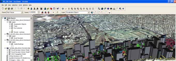
3 What is ArcGlobe? An ArcGIS desktop application that provides interactive 3D visualization of large amounts of geographic data Supports 3D analysis of spatial data Allows seamless transitions between global, local and street-level scales Uses standard ArcGIS data sources and layers It is a 3D Mapping front-end to a GIS system


4 What is 3D Mapping? A Solution for viewing spatial data and performing analysis in a 3D visualization environment using GIS. 3D GIS has applicability in fields such as Geography, Geology, Environment Modeling, Meteorology, Climatology, Hydrology, Utility Management, Disaster Management, Real estate, Location Based Services etc...
5 What can 3D GIS Do for you? Accurately represent geographic entities as they are in the real world. Can be easily used to create realistic models (e.g. city models) and allows visualization of what if scenarios (for planning and decision support systems (DSS). Transforms your 2D maps into 3D scenes (and globes) which allows you to extract more information from your data in regards to scale, visibility, line of sight etc...
6 What do I need to run ArcGlobe? Software: 3D Analyst Extension with ArcView, ArcEditor or ArcInfo 9.0, 9.1, 9.2, 9.3 latest Service Packs recommended Hardware: CPU at least 1.5 GHz Additional disk space for data cache, depending on need OpenGL 1.2 compatible video card with minimum 32 MB of memory (64 MB or greater preferred) Data: Most ArcGIS-supported datasets ArcGIS Online ArcGIS Data and Maps DVD
7 DEMO 1 Getting started with your 3D document


8 Displaying data in ArcGlobe Layer categories Draped On the globe surface Elevation Defining globe surface Floating Above or below globe surface Note - Drawing order of overlapping draped and elevation layers is set via Type tab on TOC and not on Display tab.

9 Layer Draw Order (Draped) Draped layers are overlaid following their order in the Type tab of the Table of Contents Order is important for transparency to work correctly

10 Floating Layers Draped layers (images, features) can be made floating at a constant height or on their own surface Can be used to show data (e.g. chemical concentration) as overlaid surface, to add features with own elevation above or below globe


11 Layer Draw Order (Floating) When using floating layers use transparency, the correct see-though position must be set Example: If layers with transparency are to be watched from the top:
12 ArcGlobe tools How to get around quickly in ArcGlobe? Standard navigation tools Navigate, Fly, Walk and Orbital Fly tool Zoom to layer(s) extent, full extent Zoom to selected features Bookmarks and Find tool Animation Toolbar 3D Graphics Toolbar KML Toolbar Publisher Toolbar

13 ArcGlobe tools Layer Transparency Transparency can be changed interactively in the 3D Effects toolbar Can also be set in the Display property page of the layer
 Tile based")
14 ArcGlobe tools Layer Visibility Ranges Important to display large sets of 3D features Can be used to manage multiple representations Units are defined in Globe properties (compare with distance in status bar) Tile based visibility


15 ArcGlobe tools Use bookmarks, like in ArcMap, to store interesting views These can be used later to create animations

16 ArcGlobe tools Use the Find tool to zoom to locations ArcWeb Place Finder uses ESRI s ArcWeb Service to find locations (requires internet connection)

17 ArcGlobe tools Animation tools Capture views and create quickly a presentation Create flybys from a path feature Animate groups of layers Export videos
18 ArcGlobe tools Pause data caching tool -F9 Similar to Pause tool in ArcMap Pauses all data preparation processes, but data already in memory is still displayed Allows for easier navigation and option setting until user is ready for full display Draft Mode tool Use for faster navigation performance without editing layer properties or invalidating your existing cache. Includes five configurable properties for: reducing the level of detail for elevation and raster layers; disabling 3D marker symbols; disabling object textures; disabling line densification; and showing a subset of features.

19 ArcGIS integration Layers can be copied (copy & paste) directly between ArcMap, ArcScene and ArcGlobe The GeoProcessing toolbox and ModelBuilder are integrated within ArcGlobe Results of analysis can be displayed directly
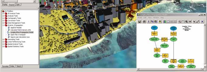
20 ArcGIS integration

21 ArcGIS integration ArcReader PMF files can be created from ArcGlobe, after enabling the Publisher extension
22 DEMO 2: Visual Analysis in 3D
23 What s new in ArcGIS 9.3 ArcGlobe usability and performance enhancements Default ArcGIS Online content. Globe graphics improvements Improved bookmark support New Functionality Improved support for KML 2.1 includes screen overlays, autorefresh of KML network links, etc. Improved Pan functionality. Support for 3D models defined in COLLADA files. Perimeter-based extrusion for lines and polygons where the line is extruded on a per-vertex basis. Tracking Analyst extension supported in ArcGlobe. Bill-boarded marker symbols now support images. Support for HTML popups in ArcGlobe and ArcScene
24 What s new in ArcGIS 9.3 Developer Support New 3D analysis/geometry operators for developers Improved Documentation _overview_of_3d_analyst New tutorial exercise on building realistic 3D views (eg: virtual cities) For more read What s new in ArcGIS 9.3 Documentation S_93.pdf
25 Using 3D Objects 3D (textured) Objects can be added to ArcGlobe by: Symbolizing points with 3D markers Out-of-the-box libraries of 3D Objects Imported from VRML,.3ds,.flt,.skp and.dae files Importing Multipatch features created elsewhere Using custom tools like the Façade Tool


26 Using 3D Text Annotation layers can be created in ArcMap and displayed in ArcGlobe Symbol substitution can be applied in ArcGlobe


27 Draped Text Display text draped on a 3D surface Goals Display annotation layers and labeled feature layers draped on the globe surface Billboarded annotation Draped annotation Draped line layer with labels
28 3D Graphics and KML support 3D Graphics Toolbar Digitize point, line, polygons and text graphics Apply 3D Symbology to the graphic elements Keyhole MarkUp Language XML-based language for defining the display of 3D spatial data in Google Earth Add KML data using the KML toolbar in ArcGlobe Strong support for KML 2.1


29 Caching and Optimization ArcGlobe uses caching to optimize display performance Cache tiles are kept for each layer: in memory for immediate use and in disk for later Caches are preserved when saving a layer file or document


30 Caching and Optimization Consolidation creates a single cache for a group of layers Improve display performance when showing many images or rasterized features
31 Caching and Optimization Tips Save a document or layer file to preserve the cache Verify the size of the memory cache in the Options dialog. If it s too small or too large, it can degrade performance From time to time, clean the cache location To optimize interaction, generate the caches in advance You can do this with the Generate Cache command It can also be done by pre-visiting the area of interest, or running an animation repeatedly For more read technical papers on : Tips for Designing Interactive ArcGlobe Documents Techniques for Consuming 3D Textured Objects in ArcGlobe and ArcScene
32 DEMO 3: Authoring 3D content
33 Publishing 3D content to the web ArcGIS Server Globe Services give you the ability to publish your 3D GIS data to the Web Globe Services are efficient streaming of globe visualization pages, animation and ability to perform spatial queries on 3d data. Globe Services provide a means for generating, managing and serving optimized globe data. Both just in time (on-demand) and pre-cached data serving models are supported.


34 Who can use Globe Services Any globe enabled ArcGIS Clients ArcGIS Desktop Applications - ArcGlobe and ArcCatalog Stand alone ArcGIS Engine Applications based on the GlobeControl The Free ArcGIS clients ArcGIS Explorer and ArcReader


35 Set Cache Location to ArcGIS Server GlobeCache
36 DEMO 4 : Publishing and Consuming 3D Web Services
Esri UC2013. Technical Workshop. Type Presentation Name Here
 Type Presentation Name Here 2013 Esri International User Conference July 8 12, 2013 San Diego, California Technical Workshop 3D Analyst An Introduction Deepinder Deol Michael Contreras Why use 3D GIS?
Contents What is 3D Mapping Creating g the 3D Dataset Ingredients of a 3D Virtual City Publishing 3D Globes The Road ahead Questions and Answers
 Creating a 3D Virtual City Using ArcGIS Tamrat Belayneh Hardeep Bajwa Contents What is 3D Mapping Creating g the 3D Dataset Ingredients of a 3D Virtual City Publishing 3D Globes The Road ahead Questions
Creating, managing and utilizing a 3D Virtual City in ArcGIS Tamrat Belayneh Eric Wittner
 Creating, managing and utilizing a 3D Virtual City in ArcGIS 10.1 Tamrat Belayneh (tbelayneh@esri.com) Eric Wittner (ewittner@esri.com ) Contents 3D Mapping & Ingredients of a 3D Virtual City Creating
Answer the following general questions: 1. What happens when you right click on an icon on your desktop? When you left double click on an icon?
 Name: Date: June 27th, 2011 GIS Boot Camps For Educators Practical: Explore ArcGIS 10 Desktop Tools and functionality Day_1 Lecture 1 Sources: o ArcGIS Desktop help o ESRI website o Getting to Know ArcGIS
GEOGRAPHIC INFORMATION SYSTEMS Lecture 25: 3D Analyst
 GEOGRAPHIC INFORMATION SYSTEMS Lecture 25: 3D Analyst 3D Analyst - 3D Analyst is an ArcGIS extension designed to work with TIN data (triangulated irregular network) - many of the tools in 3D Analyst also
COPYRIGHTED MATERIAL. Introduction to 3D Data: Modeling with ArcGIS 3D Analyst and Google Earth CHAPTER 1
 CHAPTER 1 Introduction to 3D Data: Modeling with ArcGIS 3D Analyst and Google Earth Introduction to 3D Data is a self - study tutorial workbook that teaches you how to create data and maps with ESRI s
3D Analysis Tools and Visualization with ArcGIS. Jie Chang Jinwu Ma
 3D Analysis Tools and Visualization with ArcGIS Jie Chang Jinwu Ma Why 3D GIS? Because our world is 3D Improve understanding 3D is easy for everyone to understand Solve 3D problems Some spatial problems
Contents 3D Visualization (Mapping) defined Globe Data Display Management & Architecture Caching and optimization Data Preparation and Usage Tips Cust
 defined Globe Data Display Management & Architecture Caching and optimization Data Preparation and Usage Tips Cust") Developers Guide to 3D Visualization in ArcGIS 9.2 Nathan Shephard Tamrat Belayneh Developer Summit 2007 1 Contents 3D Visualization (Mapping) defined Globe Data Display Management & Architecture Caching
Developers Guide to 3D Visualization in ArcGIS 9.2 Nathan Shephard Tamrat Belayneh Developer Summit 2007 1 Contents 3D Visualization (Mapping) defined Globe Data Display Management & Architecture Caching
3D Data Modelling at Esri. Paul Hardy Business Development Consultant Esri Europe
 3D Data Modelling at Esri Paul Hardy phardy@esri.com Business Development Consultant Esri Europe Users of 3D GIS Local government Facilities management Civil engineering 3D GIS Defense / Public Safety
Cartographic Techniques and Representations
 Cartographic Techniques and Representations NEARC 2007 ESRI Technical Session ESRI, Boston Overview of Presentation Labeling and Annotation Masking Layout Tips Cartographic Representations Labeling versus
Exporting ArcScene to 3D Web Scenes. Documents. An Esri White Paper November 2013
 Exporting ArcScene to 3D Web Scenes Documents An Esri White Paper November 2013 Copyright 2013 Esri All rights reserved. Printed in the United States of America. The information contained in this document
3D Analyst Visualization with ArcGlobe. Brady Hoak, ESRI DC
 3D Analyst Visualization with ArcGlobe Brady Hoak, ESRI DC 3D GIS Viewing geospatial data in 3D leads to new insights 2D 3D Sometimes you need to edit your data in 3D 2D 3D Some problems can only be solved
What's New in ArcGIS 9.2 Service Packs
 What's New in ArcGIS 9.2 Service Packs 18 July 2007 Updated for Service Pack 3 This document describes the main enhancements to 9.2 added by the service packs. It does not cover the bug fixes and quality
Exercise 1: Getting to know ArcGIS
 The Scenario You are working for the California Visitor s Commission. You have been asked to prepare a map of California for several dignitaries from out of the country. Your map will need to include enough
What's New in ArcGIS 9.2 Service Packs
 What's New in ArcGIS 9.2 Service Packs 8 July 2008 Updated for Service Pack 6 This document describes the main enhancements to 9.2 added by the service packs. It does not cover the bug fixes and quality
From 2D to 3D at Esri
 From 2D to 3D at Esri OGC/EuroSDR workshop on CityGML in National Mapping Paul Hardy phardy@esri.com Business Development Consultant National Mapping & Cadastre Esri 3D GIS Visualize Manage Share Analyze
ArcMap: Tips and Tricks
 Esri International User Conference San Diego, California Technical Workshops July 23 27, 2012 ArcMap: Tips and Tricks Miriam Schmidts Jorge Ruiz-Valdepena Agenda Navigating ArcMap Repairing data links
Please refer to for specifics and limitations with these operating systems.
 Appendix B ArcReader User Guide For the Southeast Ocean Based Renewable Energy Project INTRODUCTION The purpose of this document is to provide guidance and assistance to users with ArcReader, so that they
An ESRI Technical Paper May 2007 Techniques for Consuming 3D Textured Objects in ArcGlobe and ArcScene
 An ESRI Technical Paper May 2007 Techniques for Consuming 3D Textured Objects in ArcGlobe and ArcScene ESRI 380 New York St., Redlands, CA 92373-8100 USA TEL 909-793-2853 FAX 909-793-5953 E-MAIL info@esri.com
ArcGIS Pro Terminology Guide
 ArcGIS Pro Terminology Guide Essential Terminology or Functionality That s New to ArcGIS Pro ArcGIS Pro Project Map Scene Ribbon Tab on the ribbon View Active view Pane Gallery Task Quick Access Toolbar
ArcGIS Pro Terminology Guide
 ArcGIS Pro Terminology Guide Sharing Terminology and User Interface Cross-Reference Share content Project package (.ppkx) Map package (.mpkx) Layer package (.lpkx) Share or publish a web layer Share Web
Bouncing ball animation made up of 6 frames
 Incorporating Animation into your Analysis and Presentation Colin Childs UC2009 Technical Workshop 1 Content What is Animation What is ArcGIS animation What can be Animated Animation concepts Building
Developers Road Map to ArcGIS Desktop and ArcGIS Engine
 Developers Road Map to ArcGIS Desktop and ArcGIS Engine Core ArcObjects Desktop Team ESRI Developer Summit 2008 1 Agenda Dev Summit ArcGIS Developer Opportunities Desktop 9.3 SDK Engine 9.3 SDK Explorer
Integrating CAD Data with ArcGIS
 Integrating CAD Data with ArcGIS Agenda An Overview of CAD Drawings CAD Data Structure in ArcGIS Visualization Georeferencing Data Conversion ArcGIS for AutoCAD Q & A CAD Drawings - Overview Widely used
ArcGIS Desktop The Road Ahead. Amadea Azerki
 ArcGIS Desktop The Road Ahead Amadea Azerki Agenda An Overview of ArcGIS 10 Desktop Enhancements User Interface Mapping Editing Analysis Sharing Q & A ArcGIS 10 Overview Focuses on Usability and Productivity
From 2D to 3D at Esri
 From 2D to 3D at Esri Paul Hardy, Esri Inc phardy@esri.com, Cambridge, UK SHORT PAPER This short paper provides an overview of the 3D capabilities of a modern GIS, illustrated by the Esri ArcGIS system,
ArcGIS Pro: Mapping & Visualization. David Watkins, Edie Punt &
 ArcGIS Pro: Mapping & Visualization David Watkins, Edie Punt & Craig Williams @daviddwatkins, @epunt, & @williamscraigm Mapping an Visualization Vision In ArcGIS Pro Improve drawing performance and quality
ArcGIS Pro. Terminology Guide
 ArcGIS Pro Terminology Guide Essential Terminology or Functionality That s New to ArcGIS Pro ArcGIS Pro Project Map Scene Ribbon Tab on the ribbon View Active view Pane Gallery Task Quick Access Toolbar
Exercise 1: An Overview of ArcMap and ArcCatalog
 Exercise 1: An Overview of ArcMap and ArcCatalog Introduction: ArcGIS is an integrated collection of GIS software products for building a complete GIS. ArcGIS enables users to deploy GIS functionality
Working with Elevation Data URPL 969 Applied GIS Workshop: Rethinking New Orleans After Hurricane Katrina Spring 2006
 Working with Elevation Data URPL 969 Applied GIS Workshop: Rethinking New Orleans After Hurricane Katrina Spring 2006 This GIS lab exercise will explore Light Detection And Ranging (LiDAR) data for New
Priming the Pump Stage II
 Priming the Pump Stage II Modeling and mapping concentration with fire response networks By Mike Price, Entrada/San Juan, Inc. The article Priming the Pump Preparing data for concentration modeling with
Schematics in ArcMap Tutorial
 Schematics in ArcMap Tutorial Copyright 1995-2010 Esri All rights reserved. Table of Contents Introducing Schematics in ArcMap Tutorial........................ 3 Exercise 1: Getting familiar with Schematics
LAB 1: Introduction to ArcGIS 8
 LAB 1: Introduction to ArcGIS 8 Outline Introduction Purpose Lab Basics o About the Computers o About the software o Additional information Data ArcGIS Applications o Starting ArcGIS o o o Conclusion To
hereby recognizes that Timotej Verbovsek has successfully completed the web course 3D Analysis of Surfaces and Features Using ArcGIS 10
 3D Analysis of Surfaces and Features Using ArcGIS 10 Completed on September 5, 2012 3D Visualization Techniques Using ArcGIS 10 Completed on November 19, 2011 Basics of Map Projections (for ArcGIS 10)
GIS Workbook #1. GIS Basics and the ArcGIS Environment. Helen Goodchild
 GIS Basics and the ArcGIS Environment Helen Goodchild Overview of Geographic Information Systems Geographical Information Systems (GIS) are used to display, manipulate and analyse spatial data (data that
Review of File Management and Introduction to ArcGIS
 Review of File Management and Introduction to ArcGIS RNR/GEOG 417/517 Overview of Presentation Discuss the objectives of the lab exercise Introduce the class directory structure General file policies Introduce
Animation in ArcMap Tutorial
 ArcGIS 9 Animation in ArcMap Tutorial Copyright 2005 2006 ESRI All Rights Reserved. Printed in the United States of America. The information contained in this document is the exclusive property of ESRI.
Implementing and Optimizing ArcGIS Server Map Caches
 Implementing and Optimizing ArcGIS Server Map Caches Sterling Quinn Jeremy Bartley David Wilcox ESRI Developer Summit 2008 1 Schedule 75 minute session 60 65 minute lecture 10 15 minutes Q & A following
Getting Started with ArcGIS for Server. Charmel Menzel and Ken Gorton
 Getting Started with ArcGIS for Server Charmel Menzel and Ken Gorton Agenda What is ArcGIS for Server? Types of Web services Publishing resources onto the Web Clients to ArcGIS for Server Editions and
Introduction to GIS 2011
 Introduction to GIS 2011 Digital Elevation Models CREATING A TIN SURFACE FROM CONTOUR LINES 1. Start ArcCatalog from either Desktop or Start Menu. 2. In ArcCatalog, create a new folder dem under your c:\introgis_2011
Lab 1: Exploring ArcMap and ArcCatalog In this lab, you will explore the ArcGIS applications ArcCatalog and ArcMap. You will learn how to use
 Lab 1: Exploring ArcMap and ArcCatalog In this lab, you will explore the ArcGIS applications ArcCatalog and ArcMap. You will learn how to use ArcCatalog to find maps and data and how to display maps in
3D in the Browser with WebGL. Chris Andrews 3D Product Manager Javier Gutierrez 3D Product Engineer
 3D in the Browser with WebGL Chris Andrews 3D Product Manager Javier Gutierrez 3D Product Engineer Just sayin This is not a programming class Goal is to help you learn about a technology area that impacts
Geographical Information Systems Institute. Center for Geographic Analysis, Harvard University. LAB EXERCISE 1: Basic Mapping in ArcMap
 Harvard University Introduction to ArcMap Geographical Information Systems Institute Center for Geographic Analysis, Harvard University LAB EXERCISE 1: Basic Mapping in ArcMap Individual files (lab instructions,
Surface Analysis with 3D Analyst
 2013 Esri International User Conference July 8 12, 2013 San Diego, California Technical Workshop Surface Analysis with 3D Analyst Khalid H. Duri Esri UC2013. Technical Workshop. Why use 3D GIS? Because
Creating Contours using ArcMap
 Creating Contours with ArcMap and ArcScene Digital elevation models (DEMs) are geospatial datasets that contain elevation values sampled according to a regularly spaced rectangular grid. They can be used
Lesson 2 Installing and Using Quantum GIS (QGIS)
") Lesson 2 Installing and Using Quantum GIS (QGIS) Use file Explorer to open County QGIS portable hard drive provided. The program execute (.exe) will be at the bottom of the list. Double click on the file.
Lesson 2 Installing and Using Quantum GIS (QGIS) Use file Explorer to open County QGIS portable hard drive provided. The program execute (.exe) will be at the bottom of the list. Double click on the file.
Creating 2D Map Caches with
 Creating 2D Map Caches with ArcGIS Server 9.2 Presented by: The multi-threaded, threaded, over-clocked, dual core Diplo Matt Still AND the fast, the furious, the fully cached, Jonathan Fisk ArcGIS Server
ArcGIS 9. Using ArcCatalog
 ArcGIS 9 Using ArcCatalog Copyright 1999, 2003 2005 ESRI All rights reserved. Printed in the United States of America. The information contained in this document is the exclusive property of ESRI. This
The ArcMap Interface and Using Basic ArcMap Analysis Tools to Create a Map
 The ArcMap Interface and Using Basic ArcMap Analysis Tools to Create a Map *You will need a computer with ESRI ArcGIS Desktop version 9.3 or higher installed* Data Download 1. Save the zipped folder with
Tutorial 1 Exploring ArcGIS
 Tutorial 1 Exploring ArcGIS Before beginning this tutorial, you should make sure your GIS network folder is mapped on the computer you are using. Please refer to the How to map your GIS server folder as
What s New in Desktop 10.1
 What s New in Desktop 10.1 Damian Spangrud Esri Redlands Trip Down Memory Lane ArcGIS A Complete System for Geographic Information Cloud Web Online Mobile Enterprise Desktop Sharing Information sharing
Server Usage & Third-Party Viewers
 Server Usage & Third-Party Viewers October 2016 HiPER LOOK Version 1.4.16.0 Copyright 2015 PIXIA Corp. All Rights Reserved. Table of Contents HiPER LOOK Server Introduction... 2 Google Earth... 2 Installation...2
ArcGIS Basics Working with Labels and Annotation
 ArcGIS Basics Working with Labels and Annotation Labeling in ArcGIS has changed considerably from the old ArcView 3.X version. In ArcGIS label positions are generated automatically, are not selectable,
Welcome to NR402 GIS Applications in Natural Resources. This course consists of 9 lessons, including Power point presentations, demonstrations,
 Welcome to NR402 GIS Applications in Natural Resources. This course consists of 9 lessons, including Power point presentations, demonstrations, readings, and hands on GIS lab exercises. Following the last
Annotation/Labeling Workshop. Tim Rankin Pat Dolan
 Annotation/Labeling Workshop Tim Rankin Pat Dolan Agenda 8:00am - Introductions 8:05am - Goals of the Workshop 8:15am Labeling 8:45am Annotation Part I 9:15am Break 9:25am Annotation Part II 9:50am Questions
Pictometry for ArcGIS Desktop Local Release Notes
 Version 10.4 The Desktop - Local 10.4 extension is compatible with ArcGIS Desktop 10.4. Version 10.3.2 This extension includes a new installer, which allows you to select a location (other than Program
Using ArcScan for ArcGIS
 ArcGIS 9 Using ArcScan for ArcGIS Copyright 00 005 ESRI All rights reserved. Printed in the United States of America. The information contained in this document is the exclusive property of ESRI. This
ArcGIS 9. Using ArcCatalog
 ArcGIS 9 Using ArcCatalog Copyright 1999, 2003 2004 ESRI All rights reserved. Printed in the United States of America. The information contained in this document is the exclusive property of ESRI. This
ArcGIS 9. Using ArcReader
 ArcGIS 9 Using ArcReader Copyright 2003 2004 ESRI. All Rights Reserved. Printed in the United States of America. The information contained in this document is the exclusive property of ESRI. This work
Copyright information. U.S. Government Restricted/Limited Rights. ESRI Trademarks. Copyright ESRI All rights reserved
 Copyright 1999-2007 ESRI All rights reserved Copyright information The information contained in this document is the exclusive property of ESRI and its licensor(s). This work is protected under United
GIS LAB 8. Raster Data Applications Watershed Delineation
 GIS LAB 8 Raster Data Applications Watershed Delineation This lab will require you to further your familiarity with raster data structures and the Spatial Analyst. The data for this lab are drawn from
What's New at ArcPad 6
 What's New at ArcPad 6 An ESRI White Paper April 2002 ESRI 380 New York St., Redlands, CA 92373-8100, USA TEL 909-793-2853 FAX 909-793-5953 E-MAIL info@esri.com WEB www.esri.com Copyright 2002 ESRI All
ArcGIS 4: Sharing Content on the Web STUDENT EDITION
 ArcGIS 4: Sharing Content on the Web STUDENT EDITION Copyright 2016 Esri All rights reserved. Course version 3.1.1. Version release date July 2016. Printed in the United States of America. The information
Best Practices for Designing Effective Map Services
 2013 Esri International User Conference July 8 12, 2013 San Diego, California Technical Workshop Best Practices for Designing Effective Map Services Ty Fitzpatrick Tanu Hoque What s in this session Map
Sharing 3D Content on the Web
 Sharing 3D Content on the Web Nathan Shephard, Gert van Maren Why 3D GIS? Because our world is 3D Improve understanding 3D is easy for everyone to understand Better communication 3D makes it easier to
Introduction to ArcGIS Server 10.1
 Introduction to ArcGIS Server 10.1 E-Learning for the GIS Professional Any Time, Any Place! geospatialtraining.com Module Outline What is ArcGIS Server? GIS Resources and Services ArcGIS Server Components
What s s Coming in ArcGIS 10 Desktop
 What s s Coming in ArcGIS 10 Desktop Damian Spangrud ArcGIS Product Manager, ESRI dspangrud@esri.com (or at least turn to silent) ArcGIS 10 A Simple & Pervasive System for Using Maps & Geographic Information
ArcGIS Pro: What s New in Editing and Data Management
 Federal GIS Conference February 9 10, 2015 Washington, DC ArcGIS Pro: What s New in Editing and Data Management Robert LeClair ArcGIS Pro Overview Esri FedUC 2015 Technical Workshop ArcGIS Pro: What's
ArcGIS 9. Maplex Tutorial
 ArcGIS 9 Maplex Tutorial Copyright 004 006 ESRI All rights reserved. Printed in the United States of America. The information contained in this document is the exclusive property of ESRI. This work is
Outline Overview of Spatiotemporal data Storage and management of temporal data Feature Raster Array (netcdf) Visualization of temporal data Analysis
 Visualization of temporal data Analysis") Working with Temporal Data in ArcGIS Nawajish Noman Jeff Bigos Workshop on Spatial-Temporal Modeling Center for Geographic Analysis, Harvard University, April 10 th 2009 Outline Overview of Spatiotemporal
Working with Temporal Data in ArcGIS Nawajish Noman Jeff Bigos Workshop on Spatial-Temporal Modeling Center for Geographic Analysis, Harvard University, April 10 th 2009 Outline Overview of Spatiotemporal
Using GIS to Site Minimal Excavation Helicopter Landings
 Using GIS to Site Minimal Excavation Helicopter Landings The objective of this analysis is to develop a suitability map for aid in locating helicopter landings in mountainous terrain. The tutorial uses
Basic Tasks in ArcGIS 10.3.x
 Basic Tasks in ArcGIS 10.3.x This guide provides instructions for performing a few basic tasks in ArcGIS 10.3.1, such as adding data to a map document, viewing and changing coordinate system information,
Data Interoperability Extension Tutorial
 Data Interoperability Extension Tutorial Copyright 1995-2012 Esri All rights reserved. Table of Contents About the Data Interoperability extension tutorial...................... 3 Exercise 1: Using direct-read
Using ArcCatalog. GIS by ESRI
 Using ArcCatalog GIS by ESRI Copyright 1999, 2001 ESRI All rights reserved Printed in the United States of America The information contained in this document is the exclusive property of ESRI This work
Getting Started With LP360
 Getting Started With LP360 12/22/2015 1 Contents What is LP360?... 3 System Requirements... 3 Installing LP360... 4 How to Enable the LP360 Extension... 4 How to Display the LP360 Toolbar... 4 How to Import
Introduction to ArcGIS I
 Introduction 1-1 What is ArcGIS? ArcGIS Clients ArcReader E X T E N S I O N S ArcGIS Desktop ArcView ArcEditor ArcInfo ArcGIS Engine ArcPad Custom Application E X T E N S I O N S Web Browser Components
Tutorial 1: Finding and Displaying Spatial Data Using ArcGIS
 Tutorial 1: Finding and Displaying Spatial Data Using ArcGIS This tutorial will introduce you to the following: Websites where you may browse to find geospatial information Identifying spatial data, usable
What should y you expect in this session? Basic to advanced topics Outline What is map caching? Why should I cache? Caching workflow How to create a c
 Designing, Deploying, and Using Cached Map Services David Crosby & Craig Mesimer What should y you expect in this session? Basic to advanced topics Outline What is map caching? Why should I cache? Caching
Building 3D Cities Using Esri CityEngine STUDENT EDITION
 Building 3D Cities Using Esri CityEngine STUDENT EDITION Copyright 2017 Esri All rights reserved. Course version 2.0. Version release date February 2017. Printed in the United States of America. The information
Advanced PDF features
 1 of 7 2/17/2009 10:56 PM Show Navigation Hide Navigation You are here: Mapping and v isualization > Page layout and map composition > Map output Advanced PDF features Release 9.3 Last modified November
LAB #7 Creating TIN and 3D scenes (ArcScene) GISC, UNIVERSITY OF CALIFORNIA BERKELEY
 GISC, UNIVERSITY OF CALIFORNIA BERKELEY") LAB #7 Creating TIN and 3D scenes (ArcScene) GISC, UNIVERSITY OF CALIFORNIA BERKELEY The purpose of this laboratory is to introduce and explore surface data analysis using a vector data model: TIN. We
LAB #7 Creating TIN and 3D scenes (ArcScene) GISC, UNIVERSITY OF CALIFORNIA BERKELEY The purpose of this laboratory is to introduce and explore surface data analysis using a vector data model: TIN. We
City of La Crosse Online Mapping Website Help Document
 City of La Crosse Online Mapping Website Help Document This document was created to assist in using the new City of La Crosse online mapping sites. When the website is first opened, a map showing the City
Feature Analyst Quick Start Guide
 Feature Analyst Quick Start Guide Change Detection Change Detection allows you to identify changes in images over time. By automating the process, it speeds up a acquisition of data from image archives.
introduction to 3D data
 introduction to 3D data MODELING WITH ARCGIS 3D ANALYST AND GOOGLE EARTH K. HEATHER KENNEDY Introduction to 3D Data Introduction to 3D Data Modeling with ArcGIS 3D Analyst and Google Earth K. Heather
ModelBuilder: An Introduction. Kevin Armstrong
 ModelBuilder: An Introduction Kevin Armstrong What is ModelBuilder? A user-friendly way to automate a series of tools Part of the ArcGIS geoprocessing framework - ModelBuilder can run any tool in the ArcToolbox,
START>PROGRAMS>ARCGIS>
 Department of Urban Studies and Planning Spring 2006 Department of Architecture Site and Urban Systems Planning 11.304J / 4.255J GIS EXERCISE 2 Objectives: To generate the following maps using ArcGIS Software:
Explore some of the new functionality in ArcMap 10
 Explore some of the new functionality in ArcMap 10 Scenario In this exercise, imagine you are a GIS analyst working for Old Dominion University. Construction will begin shortly on renovation of the new
ArcGIS Desktop: Introduction to Geoprocessing with ModelBuilder Kevin Armstrong ESRI
 ArcGIS Desktop: Introduction to Geoprocessing with ModelBuilder Kevin Armstrong ESRI SERUG 2008 1 What is ModelBuilder? A user-friendly way to automate a series of tools Part of the ArcGIS geoprocessing
STUDENT PAGES GIS Tutorial Treasure in the Treasure State
 STUDENT PAGES GIS Tutorial Treasure in the Treasure State Copyright 2015 Bear Trust International GIS Tutorial 1 Exercise 1: Make a Hand Drawn Map of the School Yard and Playground Your teacher will provide
THE HONG KONG POLYTECHNIC UNIVERSITY DEPARTMENT OF LAND SURVEYING & GEO-INFORMATICS LSGI521 PRINCIPLES OF GIS
 THE HONG KONG POLYTECHNIC UNIVERSITY DEPARTMENT OF LAND SURVEYING & GEO-INFORMATICS LSGI521 PRINCIPLES OF GIS Student name: Student ID: Table of Content Working with files, folders, various software and
A Second Look at DEM s
 A Second Look at DEM s Overview Detailed topographic data is available for the U.S. from several sources and in several formats. Perhaps the most readily available and easy to use is the National Elevation
Delineating Watersheds from a Digital Elevation Model (DEM)
") Delineating Watersheds from a Digital Elevation Model (DEM) (Using example from the ESRI virtual campus found at http://training.esri.com/courses/natres/index.cfm?c=153) Download locations for additional
Delineating Watersheds from a Digital Elevation Model (DEM) (Using example from the ESRI virtual campus found at http://training.esri.com/courses/natres/index.cfm?c=153) Download locations for additional
Desktop. ArcGIS Server. ArcGIS
 Getting Started with ArcGIS Server Nakul Bhatia and David Crosby ESRI Charlotte 1 Agenda g Overview of ArcGIS Server 9.3.1 Working with GIS Services Using g Web GIS Service Clients ArcGIS Online Map Caching
Designing and Using Basemaps. Jennifer Hughey
 Designing and Using Basemaps Jennifer Hughey Agenda The ArcGIS System Basemaps are a key component of your system Cartographic design considerations Using basemap layers in ArcMap Best practices for designing
ArcMap Tips and Tricks
 2013 Esri International User Conference July 8 12, 2013 San Diego, California Technical Workshop ArcMap Tips and Tricks Jack Horton Jorge Ruiz-Valdepeña Esri UC2013. Technical Workshop. Jorge s Agenda
GIS IN ECOLOGY: VISUALIZING IN 3D
 GIS IN ECOLOGY: VISUALIZING IN 3D Contents Introduction... 2 3D Analyst and ArcScene... 2 3D Data... 2 Course Data Sources... 3 Instructions for Copying the Course Dataset... 4 Tasks... 4 Visualizing and
Getting Started. Extruding Features. Convert to feature class
 http://gmv.cast.uark.edu A Method Store for Advanced Survey and Modeling Technologies Mon, 01 Apr 2013 03:29:18 +0000 en-us hourly 1 http://wordpress.org/?v=3.5.1 http://gmv.cast.uark.edu/modeling/software-visualization/sketchup/workflow-sketchup/arcscene-tosketchup-to-arcscene/
ArcGIS for Developers. Kevin Deege Educational Services Washington DC
 ArcGIS for Developers Kevin Deege Educational Services Washington DC Introductions Who am I? Who are you? ESRI Product Development Experience? What development languages are you using? What types of applications
GeoEarthScope NoCAL San Andreas System LiDAR pre computed DEM tutorial
 GeoEarthScope NoCAL San Andreas System LiDAR pre computed DEM tutorial J Ramón Arrowsmith Chris Crosby School of Earth and Space Exploration Arizona State University ramon.arrowsmith@asu.edu http://lidar.asu.edu
Lab Assignment 4 Basics of ArcGIS Server. Due Date: 01/19/2012
 Lab Assignment 4 Basics of ArcGIS Server Due Date: 01/19/2012 Overview This lab assignment is designed to help you develop a good understanding about the basics of ArcGIS Server and how it works. You will