IMOS/AODN ocean portal: tools for data delivery. Roger Proctor, Peter Blain, Sebastien Mancini IMOS
|
|
|
- Amy Jacobs
- 5 years ago
- Views:
Transcription


1 IMOS/AODN ocean portal: tools for data delivery Roger Proctor, Peter Blain, Sebastien Mancini IMOS

2 Data from IMOS: The six Nodes Bluewater and Climate Node open ocean focus Five Regional Nodes continental shelf and coastal focus Western Australia Queensland WAIMOS QIMOS New South Wales Southern Australia Tasmania BwC SAIMOS NSW-IMOS TasIMOS

3
 publicly accessible directories archive storage of raw")

4 Elements of the information infrastructure Distributed Data Storage All IMOS data stored on ARCS/AERO Data Fabric ( RDSI) publicly accessible directories archive storage of raw data Data Delivery OPeNDAP servers/thredds catalog; Data Fabric Data subsetting and aggregation netcdf, flat ascii, csv IMOS > 2 million files, 30Tb data, ~2000 metadata records
 Legal standard: Creative")
 OPeNDAP Sensor Observation Service (SOS) data visualisation:")
5 IMOS Data Standards metadata standard: ISO 19115/19139 Marine Community Profile Metadata exchange: Catalog Services for the Web (CSW) Legal standard: Creative Commons data format: Climate and Forecast NetCDF Convention data download: Web Feature Service (WFS) OPeNDAP Sensor Observation Service (SOS) data visualisation: Web Map Service (WMS)
6 IMOS Data Standards metadata standard: ISO 19115/19139 Marine Community Profile Metadata exchange: Catalog Services for the Web (CSW) Legal standard: Creative Commons data format: Climate and Forecast NetCDF Convention data download: Web Feature Service (WFS) OPeNDAP Sensor Observation Service (SOS) data visualisation: Web Map Service (WMS)
 IMOS measures > 250")
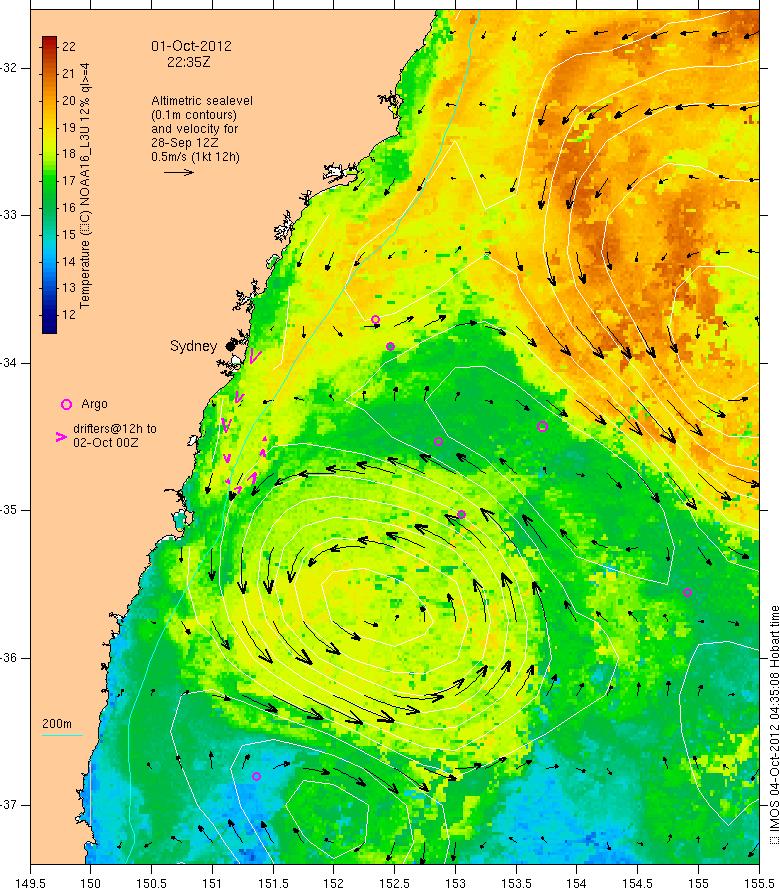
7 Portal screenshot (October 2012) IMOS measures > 250 parameters

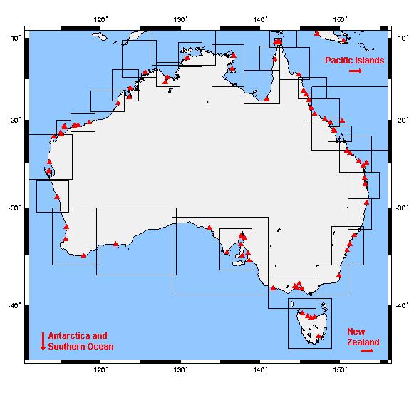
8 IMOS observations in the coastal zone
9 IMOS Ocean Portal: imos.aodn.org.au

10 IMOS Ocean Portal: imos.aodn.org.au

11 Integrated latest observations


12 Map view or search

13 HF Radar data in WA
14 Filtering datasets
15 Filtering datasets
16 Filtering datasets
17 Select mooring data by region

18 Argo Aggregations By year By region Atlantic N Pacific S Pacific Indian
 Southern Ocean Tasman")
19 SOOP XBT Aggregations by line, by year by region Australia (NE, NW, SE, SW) Southern Ocean Tasman Sea

20 an interoperable, online network of marine and coastal data resources Australia s interface to large amounts of otherwise undiscoverable marine data infrastructure & visualisation tools to establish free access to data and metadata neither generating, nor storing data! #1 challenge of publishing interoperable data from multiple disciplines! #2 the AODN can only work if people / researchers / institutes agree to share data! Australian Antarctic Division Australian Institute of Marine Science Bureau of Meteorology CSIRO Marine and Atmospheric Research Geoscience Australia Royal Australian Navy Hydrography and Metoc Branch Australian Ocean Data Centre Joint Facility (AODC JF)

21 IMOS and AODN distributed data and information network AAD RAN GA AIMS CSIRO BoM AODN portal NIWA Pacific Islands? ALA TERN
22 User discovers Datasets Through Metadata query AODN Portal User constructs Maps AODN Functional Diagram User Selects from map and plots or Downloads data User Downloads Data files Master Metadata Catalog (Geonetwork) Harvesting Geonetwork Metadata Catalog Geoserver Web Services (WMS, WFS) THREDDS Catalogs netcdf data files Harvesting Other Metadata Catalogs Imagery, Shapefiles Relational Databases AODN portal
 Harvesting Geonetwork Metadata Catalog Geoserver Web Services (WMS, WFS) THREDDS Catalogs netcdf data files Harvesting Other Metadata Catalogs Imagery, Shapefiles")
23 User discovers Datasets Through Metadata query AODN Portal User constructs Maps AODN Functional Diagram User Selects from map and plots or Downloads data User Downloads Data files A node of AODN Master Metadata Catalog (Geonetwork) Harvesting Geonetwork Metadata Catalog Geoserver Web Services (WMS, WFS) THREDDS Catalogs netcdf data files Harvesting Other Metadata Catalogs Imagery, Shapefiles Relational Databases AODN portal


24 User discovers Datasets Through Metadata query AODN Portal User constructs Maps AODN Functional Diagram User Selects from map and plots or Downloads data User Downloads Data files A node of AODN Master Metadata Catalog (Geonetwork) Harvesting Geonetwork Metadata Catalog Geoserver Web Services (WMS, WFS) THREDDS Catalogs netcdf data files Harvesting Other Metadata Catalogs Imagery, Shapefiles Relational Databases AODN portal
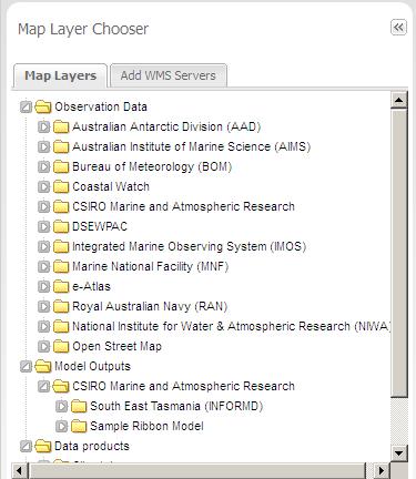
25 Map layers for contributors, includes IMOS

26

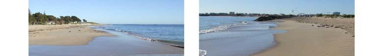
27 CoastalWatch beach cameras
28 CoastalWatch beach cameras
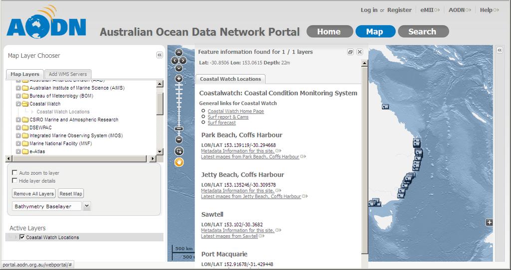

29 CoastalWatch beach cameras
30 Shoreline photos in WA

31 Shoreline photos in WA
32 Shoreline photos in WA


33 Shoreline photos in WA

34 AODN brings in additional datasets, e.g. XBT and CTD data from the Navy and the Research Vessels

35 And coastal observations for the GBR

36
37


38

39 Spatial/Temporal Search Search for data in a space time region. Combine with other search criteria such as parameter.


40 Faceted Search Faceted searching is due to be released in late October. Faceted searching became popular in online retailing, and is now a ubiquitous feature for searching lists on web sites. The portal s implementation will allow navigation of datasets using facets such as parameter, location, and organisation. Other facets will be added as the MCP schema is refined.

41 Machine interface for searching RAMADDA provides a web query service for searching IMOS & AODN datasets. This interface is used by external services such as the Marine Virtual Laboratory (MARVL). It is available at It is possible to query by date, time, parameter, and many other criteria. OPeNDAP URLs can be returned for further querying. Output types include JSON and XML.

42 Animation of Gridded Data Visualise your data before downloading Animations controls: Play, Pause, Fast Forward, etc Select a date range Select an individual time step Download animated gifs Share animations via a URL

43 Model animations e.g. Ribbon model

44 SETAS model


45 Aggregate Gridded Data Data split across multiple files can be subsetted, aggregated, and returned as a single 3D file covering a requested space/time region. The service is backed by the AODAAC aggregator and will soon be available through the portal s user interface.
46 Next steps


47 Next steps subset regions and along tracks

 2.")

48 Australian National Environmental Information Infrastructure IMOS data as a demonstrator within prototype NEII NEII Services Pathfinder Architecture overview 1. Spatial Information Services Stack (SISS) 2. Production information model registry 3. SISS configured for NEII data services across: air, land, water, ocean 4. Linked-data demonstrator 5. User interface for menu-driven querying
49 Linking IMOS data to NEII IMOS/AODN
50 Linking IMOS data to NEII IMOS/AODN SOS

51 Linking IMOS data to NEII IMOS/AODN ncsos
 and")
52 Timeseries comparison of model ( ) and observation ( )
53 Scope of Models and Products Bluelink? OceanMaps, other ocean models Atmos forcing? ACCESS Climatologies? BRAN, CARS, NW shelf? BGC data bio-optical database + NRS + SOOP MARS database inclusion? Sedsim data and model? Bathy data? Wave data? Sea level data?
54 Publish Your Model Output! The AODN publishes model data The AODN cookbook describes how to contribute
55 The End
Keywords: information infrastructure, marine data network
 AUSTRALIAN OCEAN DATA NETWORK (AODN) Publicly funded data, publicly available Roger Proctor, Patrick Gorringe, Kate Roberts Integrated Marine Observing System, University of Tasmania, Private Bag 21, Tas
eresearch Collaboration across the Pacific:
 eresearch Collaboration across the Pacific: Marine Systems and Australian Marine Science Craig Johnson University of Tasmania Outline Introduce the Australian Ocean Network Possibilities for trans-pacific
Oceanic Observatory for the Iberian Shelf
 Oceanic Observatory for the Iberian Shelf B.Vila Barcelona, 26th September 2016 Objectives: The Project Improve the oceanic observation at the North Western Iberian coast (meteorological, oceanographical
AODN update & priorities. Roger Proctor, Sebastien Mancini, Peter Blain
 AODN update & priorities Roger Proctor, Sebastien Mancini, Peter Blain Extreme events in the past year Completed migration of IMOS collections & services to Amazon Web Services Shut down of old AODN portal
Compass INSPIRE Services. Compass INSPIRE Services. White Paper Compass Informatics Limited Block 8, Blackrock Business
 Compass INSPIRE Services White Paper 2010 Compass INSPIRE Services Compass Informatics Limited Block 8, Blackrock Business Park, Carysfort Avenue, Blackrock, County Dublin, Ireland Contact Us: +353 1 2104580
Introduction to INSPIRE. Network Services
 Introduction to INSPIRE. Network Services European Commission Joint Research Centre Institute for Environment and Sustainability Digital Earth and Reference Data Unit www.jrc.ec.europa.eu Serving society
Data discovery and access via the SeaDataNet CDI system
 Data discovery and access via the SeaDataNet CDI system Central dataproducts and data services on distributed data. Peter Thijsse MARIS CLIPC IS-ENES workshop, KNMI, November 2014 Outline 1. Introduction
Marine Virtual Laboratory (MARVL) Early Activity Milestone Report 2.0
 Early Activity Milestone Report 2.0") MARVLMilestoneReport2.0 28March2012 Marine Virtual Laboratory (MARVL) Early Activity Milestone Report 2.0 Mark Hepburn, Uwe Rosebrock, Gary Carroll, Peter R. Oke CSIRO Marine and Atmospheric Research 28
MARVLMilestoneReport2.0 28March2012 Marine Virtual Laboratory (MARVL) Early Activity Milestone Report 2.0 Mark Hepburn, Uwe Rosebrock, Gary Carroll, Peter R. Oke CSIRO Marine and Atmospheric Research 28
Ocean Data View (ODV) Manual V1.0
 Manual V1.0") Ocean Data View (ODV) Manual V1.0 Prepared by the Coastal and Regional Oceanography Lab UNSW, Australia (www.oceanography.unsw.edu.au ) for the Sydney Institute of Marine Science. Table of Contents 1 Introduction
Ocean Data View (ODV) Manual V1.0 Prepared by the Coastal and Regional Oceanography Lab UNSW, Australia (www.oceanography.unsw.edu.au ) for the Sydney Institute of Marine Science. Table of Contents 1 Introduction
Developing data catalogue extensions for metadata harvesting in GIS
 University of Bergen Department of Informatics Developing data catalogue extensions for metadata harvesting in GIS Author: André Mossige Long master thesis June 2018 Acknowledgements I would like to thank
Catalog-driven, Reproducible Workflows for Ocean Science
 Catalog-driven, Reproducible Workflows for Ocean Science Rich Signell, USGS, Woods Hole, MA, USA Filipe Fernandes, Centro Universidade Monte Serrat, Santos, Brazil. 2015 Boston Light Swim, Aug 15, 7:00am
Metadata for Data Discovery: The NERC Data Catalogue Service. Steve Donegan
 Metadata for Data Discovery: The NERC Data Catalogue Service Steve Donegan Introduction NERC, Science and Data Centres NERC Discovery Metadata The Data Catalogue Service NERC Data Services Case study:
Online intercomparison of models and observations using OGC and community standards
 Online intercomparison of models and observations using OGC and community standards Alastair Gemmell * Jon Blower Keith Haines Adit Santokhee Reading e-science e Centre, Environmental Systems Science Centre,
The AusGIN Geoscience Portal:
 The AusGIN Geoscience Portal: A new age of geoscience data delivery Ollie Raymond and Carina Kemp Geoscience Australia Government Geoscience Information Committee Australian Geoscience Information Network
Desarrollo de una herramienta de visualización de datos oceanográficos: Modelos y Observaciones
 Desarrollo de una herramienta de visualización de datos oceanográficos: Modelos y Observaciones J. Fernandez, J. Lopez, I. Carlos, F. Jerez, F. Hermosilla, M. Espino SIMO, LIM-UPC, CIIRC FIELD_AC 7 th
New Datasets, Functionality and Future Development. Ashwanth Srinivasan, (FSU) Steve Hankin (NOAA/PMEL) Major contributors: Jon Callahan (Mazama(
 Steve Hankin (NOAA/PMEL) Major contributors: Jon Callahan (Mazama(") HYCOM Data Service New Datasets, Functionality and Future Development Ashwanth Srinivasan, (FSU) Steve Hankin (NOAA/PMEL) Major contributors: Jon Callahan (Mazama( Consulting) Roland Schweitzer (Weathertop
HYCOM Data Service New Datasets, Functionality and Future Development Ashwanth Srinivasan, (FSU) Steve Hankin (NOAA/PMEL) Major contributors: Jon Callahan (Mazama( Consulting) Roland Schweitzer (Weathertop
INSPIRE & Environment Data in the EU
 INSPIRE & Environment Data in the EU Andrea Perego Research Data infrastructures for Environmental related Societal Challenges Workshop @ pre-rda P6 Workshops, Paris 22 September 2015 INSPIRE in a nutshell
European Marine Data Exchange
 European Marine Data Exchange By Dick M.A. Schaap MARIS (NL) EU SeaDataNet Technical Coordinator EU EMODnet Ingestion Coordinator Noordzeedagen 2018 - October 2018 Acquisition of ocean and marine data
The Many Facets of THREDDS Thematic Real-time Environmental Distributed Data Services
 The Many Facets of THREDDS Thematic Real-time Environmental Distributed Data Services For March 2007 Unidata Policy Committee Meeting Ben Domenico 1 Motivation From the Unidata 2003 proposal: utilizing
Uniform Resource Locator Wide Area Network World Climate Research Programme Coupled Model Intercomparison
 Glossary API Application Programming Interface AR5 IPCC Assessment Report 4 ASCII American Standard Code for Information Interchange BUFR Binary Universal Form for the Representation of meteorological
Implementing a Data Quality Strategy to simplify access to data
 IN43D-07 AGU Fall Meeting 2016 Implementing a Quality Strategy to simplify access to data Kelsey Druken, Claire Trenham, Ben Evans, Clare Richards, Jingbo Wang, & Lesley Wyborn National Computational Infrastructure,
Making data access easier with OPeNDAP. James Gallapher (OPeNDAP TM ) Duan Beckett (BoM) Kate Snow (NCI) Robert Davy (CSIRO) Adrian Burton (ARDC)
 Duan Beckett (BoM) Kate Snow (NCI) Robert Davy (CSIRO) Adrian Burton (ARDC)") Making data access easier with OPeNDAP James Gallapher (OPeNDAP TM ) Duan Beckett (BoM) Kate Snow (NCI) Robert Davy (CSIRO) Adrian Burton (ARDC) Outline Introduction and trajectory (James Gallapher) OPeNDAP
Making data access easier with OPeNDAP James Gallapher (OPeNDAP TM ) Duan Beckett (BoM) Kate Snow (NCI) Robert Davy (CSIRO) Adrian Burton (ARDC) Outline Introduction and trajectory (James Gallapher) OPeNDAP
Introduction of SeaDataNet and EMODNET Working towards a harmonised data infrastructure for marine data. Peter Thijsse MARIS
 Introduction of SeaDataNet and EMODNET Working towards a harmonised data infrastructure for marine data Peter Thijsse MARIS CLIPC & IS-ENES 2 workshop, KNMI, November 2014 Outline 1. Introduction to marine
Technical documentation. SIOS Data Management Plan
 Technical documentation SIOS Data Management Plan SIOS Data Management Plan Page: 2/10 SIOS Data Management Plan Page: 3/10 Versions Version Date Comment Responsible 0.3 2017 04 19 Minor modifications
Version 3 Updated: 10 March Distributed Oceanographic Match-up Service (DOMS) User Interface Design
 User Interface Design") Distributed Oceanographic Match-up Service (DOMS) User Interface Design Shawn R. Smith 1, Jocelyn Elya 1, Adam Stallard 1, Thomas Huang 2, Vardis Tsontos 2, Benjamin Holt 2, Steven Worley 3, Zaihua Ji
Distributed Oceanographic Match-up Service (DOMS) User Interface Design Shawn R. Smith 1, Jocelyn Elya 1, Adam Stallard 1, Thomas Huang 2, Vardis Tsontos 2, Benjamin Holt 2, Steven Worley 3, Zaihua Ji
The GeoPortal Cookbook Tutorial
 The GeoPortal Cookbook Tutorial Wim Hugo SAEON/ SAEOS SCOPE OF DISCUSSION Background and Additional Resources Context and Concepts The Main Components of a GeoPortal Architecture Implementation Options
Ocean, Atmosphere & Climate Model Assessment for Everyone
 Ocean, Atmosphere & Climate Model Assessment for Everyone Rich Signell USGS Woods Hole, MA Unidata 2014 DeSouza Award Presentation Boulder, CO : Sep 15, 2014 2 US Integrated Ocean Observing System (IOOS
Multi-disciplinary Interoperability: the EuroGEOSS Operating Capacities
 Multi-disciplinary Interoperability: the EuroGEOSS Operating Capacities Stefano Nativi (CNR) stefano.nativi@cnr.it Opening and context for Global Dimension Stream: EuroGEOSS contribution to the Global
Python: Working with Multidimensional Scientific Data. Nawajish Noman Deng Ding
 Python: Working with Multidimensional Scientific Data Nawajish Noman Deng Ding Outline Scientific Multidimensional Data Ingest and Data Management Analysis and Visualization Extending Analytical Capabilities
Implementing a Data Quality Strategy to simplify access to data
 Implementing a Quality Strategy to simplify access to data Kelsey Druken Implementing a Quality Strategy to simplify access to data Kelsey Druken, Claire Trenham, Lesley Wyborn, Ben Evans National Computational
Data Centre NetCDF Implementation Pilot
 Data Centre NetCDF Implementation Pilot Peter Miu EUMETSAT User Conference Oslo, Sep. 2011 Splinter Session, Facilitating Data Access and Utilisation Slide: 1 EUM/OPS/VWG/11/2600 V.1 What is this Pilot
RAMADDA and THREDDS. Projects. Tom Yoksas, John Caron, Ethan Davis 1 Jeff McWhirter 2, Don Murray 3 Matthew Lazzara 4. Unidata Program Center/UCAR 2
 Use in Support of Two Disparate RAMADDA and THREDDS Projects Tom Yoksas, John Caron, Ethan Davis 1 Jeff McWhirter 2, Don Murray 3 Matthew Lazzara 4 1 Program Center/UCAR 2 UNAVCO 3 NOAA/ESRL/PSD and CIRES
The Scottish Spatial Data Infrastructure (SSDI)
") The Scottish Spatial Data Infrastructure (SSDI) INSPIRE Conference Istanbul Monday 25 th June 2012 15:55 Geoportals and registries II Tim Duffy BGS Edinburgh (trd@bgs.ac.uk) Shona Nicol Alex Ramage NERC
The Scottish Spatial Data Infrastructure (SSDI) INSPIRE Conference Istanbul Monday 25 th June 2012 15:55 Geoportals and registries II Tim Duffy BGS Edinburgh (trd@bgs.ac.uk) Shona Nicol Alex Ramage NERC
NOTICE. This document is only one section of a larger document. All sections together collectively form the NNEW Documentation.
 NOTICE This document is only one section of a larger document. All sections together collectively form the NNEW Documentation. Please be advised that: This section may need to be interpreted in the context
ARCHITECTURE OF SPATIAL DATA INFRASTRUCTURE (SDI) (DRAFT)
 (DRAFT)") ARCHITECTURE OF SPATIAL DATA INFRASTRUCTURE (SDI) (DRAFT) Author: Carlo Cipolloni September 20, 2018 Version 1.0 A SDI platform to support the SEIS in the ENP South region Introduction Based on the Contribution
ARCHITECTURE OF SPATIAL DATA INFRASTRUCTURE (SDI) (DRAFT) Author: Carlo Cipolloni September 20, 2018 Version 1.0 A SDI platform to support the SEIS in the ENP South region Introduction Based on the Contribution
Data Product Catalogue. T. Loubrieu, M. Treguer, G. Maudire, IFREMER
 Data Product Catalogue T. Loubrieu, M. Treguer, G. Maudire, IFREMER High level Scope / Requirements Product definition : result of an action or process (aiming at fulfilling user's demand). For seadatanet
OGC at KNMI: Current use and plans
 OGC at KNMI: Current use and plans 4th Workshop on the use of GIS/OGC standards in meteorology 4 th of March 2013, Reading 1. Ernst de Vreede 2. Maarten Plieger Contents 1. ADAGUC 2. Internal applications
Using the Network Common Data Form for storage of atmospheric data
 Using the Network Common Data Form for storage of atmospheric data Maarten Plieger Royal Netherlands Meteorological Institute The NetCDF4 data format (Network Common Data Form) is used within the ADAGUC
SeaDataNet, Pan-European infrastructure for marine and ocean data management + EMODNET
 SeaDataNet, Pan-European infrastructure for marine and ocean data management + EMODNET By Dick M.A. Schaap Technical Coordinator SeaDataNet & Coordinator EMODNet Bathymetry San Francisco USA, 13 December
Towards a pan-european infrastructure for marine and ocean data management + Importance of standards
 Towards a pan-european infrastructure for marine and ocean data management + Importance of standards By Dick M.A. Schaap MARIS Technical Coordinator SeaDataNet & ODIP Coordinator EMODnet Bathymetry Münster
High Performance Data Efficient Interoperability for Scientific Data
 High Performance Data Efficient Interoperability for Scientific Data Alex Ip 1, Andrew Turner 1, Dr. David Lescinsky 1 1 Geoscience Australia, Canberra, Australia Problem: Legacy Data Formats holding us
Is my institution ready for data citation? Dave Connell, Australian Antarctic Data Centre
 Is my institution ready for data citation? Dave Connell, Australian Antarctic Data Centre Am I ready? Q: How do you know if an organisation is ready for Data Citation? The Australian Antarctic Division
Development of the automatic data processing system of the Instituto Español de Oceanografía surface water sampling network
 Development of the automatic data processing system of the Instituto Español de Oceanografía surface water sampling network Gonzalo González-Nuevo, Jose Manuel Cabanas, Manuel Ruiz Villarreal, Elena Tel,
C3S Data Portal: Setting the scene
 C3S Data Portal: Setting the scene Baudouin Raoult Baudouin.raoult@ecmwf.int Funded by the European Union Implemented by Evaluation & QC function from European commission e.g.,fp7 Space call Selected set
AS/NZS ISO 19157:2015
 AS/NZS ISO 19157:2015 (ISO 19157:2013, IDT) Australian/New Zealand Standard Geographic information Data quality Superseding AS/NZS ISO 19113:2004, AS/NZS ISO 19114:2005, and AS/NZS ISO 19138:2008 AS/NZS
Lynnes, Yang, Hu, Domenico and Enloe Category: Technical Note March Interoperability between OGC CS/W and WCS Protocols
 Status of this RFC This RFC Technical Note describes a project to provide a catalog search service for the Thematic Realtime Environmental Data Distribution System (THREDDS). Specifically, the project
Facility for the Automated Intelligent Monitoring of Marine Systems IMOS EIF Facility Project Plan
 Facility for the Automated Intelligent Monitoring of Marine Systems 1011-13 IMOS EIF Facility Project Plan Infrastructure Investment: IMOS Facility: Operating Institution: Facility Leader (for this Proposal):
DanubeGIS User Manual Document number: Version: 1 Date: 11-Nov-2016
 DanubeGIS User Manual Document number: Version: 1 Date: 11-Nov-2016 Imprint Published by: ICPDR International Commission for the Protection of the Danube River ICPDR 2016 Contact ICPDR Secretariat Vienna
The CEDA Web Processing Service for rapid deployment of earth system data services
 The CEDA Web Processing Service for rapid deployment of earth system data services Stephen Pascoe Ag Stephens Phil Kershaw Centre of Environmental Data Archival 1 1 Overview of CEDA-WPS History first implementation
MARINE SDI FOR HYDROGRAPHIC HOW HYDROGRAPHIC SURVEYS CAN BENEFIT FROM IMPLEMENTATION OF MARINE SPATIAL DATA INFRASTRUCTURES
 MARINE SDI FOR HYDROGRAPHIC HOW HYDROGRAPHIC SURVEYS CAN BENEFIT FROM IMPLEMENTATION OF MARINE SPATIAL DATA INFRASTRUCTURES MAIN IMAGE: HafenCity: Produced by the Hamburg Port Authority using CARIS BASE
The Alaska Marine Information System
 The Alaska Marine Information System Dr. Mark Johnson Professor of Marine Science Institute of Marine Science University of Alaska Fairbanks Google Alaska Ocean Observing System or AOOS See Access the
PARR for the Course: GIS and Public Access to NOAA Fisheries Research Data
 PARR for the Course: GIS and Public Access to NOAA Fisheries Research Data Tiffany C. Vance and Nazila Merati NOAA/NMFS/Alaska Fisheries Science Center Public Access to Research Results (PARR) Publications
Clare Richards, Benjamin Evans, Kate Snow, Chris Allen, Jingbo Wang, Kelsey A Druken, Sean Pringle, Jon Smillie and Matt Nethery. nci.org.
 The important role of HPC and data-intensive infrastructure facilities in supporting a diversity of Virtual Research Environments (VREs): working with Climate Clare Richards, Benjamin Evans, Kate Snow,
Elements of sustained data management solutions for climate
 WMO Elements of sustained data management solutions for climate Peer Hechler, Omar Baddour WMO; Data Management Applications Division Introduction WMO promotes collaboration among its Members to improve
BIG DATA CHALLENGES A NOAA PERSPECTIVE
 BIG DATA CHALLENGES A NOAA PERSPECTIVE Dr. Edward J. Kearns NASA Examiner, Science and Space Branch, OMB/EOP and Chief (acting), Remote Sensing and Applications Division National Climatic Data Center National
Geospatial exploitation Products (GXP ) GXP PLATFORM v2.2.1 RELEASE ENHANCEMENTS
 GXP PLATFORM v2.2.1 RELEASE ENHANCEMENTS") Geospatial exploitation Products (GXP ) GXP PLATFORM v2.2.1 RELEASE ENHANCEMENTS GXP PLATFORM v2.2.1 A POWERFUL FOUNDATION FOR NEW CAPABILITIES IN THE GXP SUITE OF PRODUCTS. Providing the foundation for
Geospatial exploitation Products (GXP ) GXP PLATFORM v2.2.1 RELEASE ENHANCEMENTS GXP PLATFORM v2.2.1 A POWERFUL FOUNDATION FOR NEW CAPABILITIES IN THE GXP SUITE OF PRODUCTS. Providing the foundation for
Implementation of a reporting workflow to maintain data lineage for major water resource modelling projects
 18 th World IMACS / MODSIM Congress, Cairns, Australia 13-17 July 2009 http://mssanz.org.au/modsim09 Implementation of a reporting workflow to maintain data lineage for major water Merrin, L.E. 1 and S.M.
INSPIRE overview and possible applications for IED and E-PRTR e- Reporting Alexander Kotsev
 INSPIRE overview and possible applications for IED and E-PRTR e- Reporting Alexander Kotsev www.jrc.ec.europa.eu Serving society Stimulating innovation Supporting legislation The European data puzzle 24
CSIRO and the Open Data Cube
 CSIRO and the Open Data Cube Dr Robert Woodcock, Matt Paget, Peter Wang, Alex Held CSIRO Overview The challenge The Earth Observation Data Deluge Integrated science needs Data volume, rate of growth and
Webservice-energy.org GEO Community Portal & Spatial Data Infrastructure for Energy
 Webservice-energy.org GEO Community Portal & Spatial Data Infrastructure for Energy Lionel Menard / Oct. 23 2017 Centre Observation, Impacts, Energy Research activities: Use of Earth observation data (Models,
GeoNode Integration with SDIs and Community Mapping
 GeoNode Integration with SDIs and Community Mapping Salvador Bayarri sbayarri@gmail.com World Bank Consultant Contents Accessing other SDI services Catalog harvesting through Geonetwork Cascading external
Web Map Servers. Mark de Blois. Septembre 2016
 Web Map Servers Mark de Blois Septembre 2016 Learning Objectives After this lecture you will be able to understand web map servers as used in Web-GIS applications Introduction A Web Map Server is a computer
Steve Ansari *, Stephen Del Greco, Neal Lott NOAA National Climatic Data Center, Asheville, North Carolina 2. DATA
 5A.1 THE WEATHER AND CLIMATE TOOLKIT Steve Ansari *, Stephen Del Greco, Neal Lott NOAA National Climatic Data Center, Asheville, North Carolina ABSTRACT The Weather and Climate Toolkit (WCT) is free, platform
Instructions on the use of the AODN s MEST Metadata Entry and Search Tool (M.E.S.T)
") Instructions on the use of the AODN s MEST Metadata Entry and Search Tool (M.E.S.T) http://bluenet.its.utas.edu.au Document Version 1.0 Last updated 06 August 2008 1. Introductory note:...2 2. Searching
Instructions on the use of the AODN s MEST Metadata Entry and Search Tool (M.E.S.T) http://bluenet.its.utas.edu.au Document Version 1.0 Last updated 06 August 2008 1. Introductory note:...2 2. Searching
Understanding users workflows
 Understanding users workflows GloFAS current and future data services Fredrik Wetterhall 1 University of Leeds 6 September 2017 Objective of the talk and exercise 1. Demonstrate how GloFAS data is disseminated
Standards and business models transformations
 Standards and business models transformations Inspire Conference 2017 by Jean Michel Zigna, with support of Elisabeth Lambert, Tarek Habib, Tony Jolibois and Sylvain Marty Collecte Localisation Satellite
Capturing ICAN end-user requirements for NETMAR
 Capturing ICAN end-user requirements for NETMAR Declan Dunne, CMRC d.dunne@ucc.ie ICAN Workshop 5, Oostende, 31 August - 2 September 2011 Outline! User Feedback! Geo-processing services! Cookbooks 2 User
Jeffery S. Horsburgh. Utah Water Research Laboratory Utah State University
 Advancing a Services Oriented Architecture for Sharing Hydrologic Data Jeffery S. Horsburgh Utah Water Research Laboratory Utah State University D.G. Tarboton, D.R. Maidment, I. Zaslavsky, D.P. Ames, J.L.
Unidata and data-proximate analysis and visualization in the cloud
 Unidata and data-proximate analysis and visualization in the cloud Mohan Ramamurthy and Many Unidata Staff 1 June 2017 Modeling in the Cloud Workshop Unidata: A program of the community, by the community,
ERDAS APOLLO Managing and Serving Geospatial Information
 ERDAS APOLLO Managing and Serving Geospatial Information ERDAS APOLLO Do you have large volumes of geospatial information, regularly updated data stores, and a distributed user base? Do you need a single,
OPeNDAP: Accessing HYCOM (and other data) remotely
 remotely") OPeNDAP: Accessing HYCOM (and other data) remotely Presented at The HYCOM NOPP GODAE Meeting By Peter Cornillon OPeNDAP Inc., Narragansett, RI 02882 7 December 2005 8/25/05 HYCOM NOPP GODAE 1 Acknowledgements
OPeNDAP: Accessing HYCOM (and other data) remotely Presented at The HYCOM NOPP GODAE Meeting By Peter Cornillon OPeNDAP Inc., Narragansett, RI 02882 7 December 2005 8/25/05 HYCOM NOPP GODAE 1 Acknowledgements
Relation between Geospatial information projects related to GBIF
 Relation between Geospatial information projects related to GBIF Synthesys 3.6-Synthesys 3.7-GBIF.DE- BioGeomancer The most up to date work can always be found at: http://www.biogeografia.com/synthesys
Maritime Security Panel Canadian Maritime Security Impact of Big Data
 Maritime Security Panel Canadian Maritime Security Impact of Big Data Maritime security Canada In Halifax, easy to understand Canada s connection and dependence on free access to the world s oceans In
Toward the Development of a Comprehensive Data & Information Management System for THORPEX
 Toward the Development of a Comprehensive Data & Information Management System for THORPEX Mohan Ramamurthy, Unidata Steve Williams, JOSS Jose Meitin, JOSS Karyn Sawyer, JOSS UCAR Office of Programs Boulder,
Registry Interchange Format: Collections and Services (RIF-CS) explained
 explained") ANDS Guide Registry Interchange Format: Collections and Services (RIF-CS) explained Level: Awareness Last updated: 10 January 2017 Web link: www.ands.org.au/guides/rif-cs-explained The RIF-CS schema is
ANDS Guide Registry Interchange Format: Collections and Services (RIF-CS) explained Level: Awareness Last updated: 10 January 2017 Web link: www.ands.org.au/guides/rif-cs-explained The RIF-CS schema is
Web-enabled Physical Samples: Curating and Publishing Physical Samples in CSIRO
 Web-enabled Physical Samples: Curating and Publishing Physical Samples in CSIRO Anusuriya Devaraju Web-enabled Physical Samples: Curating and Publishing Physical Samples in CSIRO Anusuriya Devaraju, Jens
Jurisdictional Updates on Positioning Infrastructure & Services across Australia. Paul Harcombe, Deputy Surveyor General NSW
 Jurisdictional Updates on Positioning Infrastructure & Services across Australia Paul Harcombe, Deputy Surveyor General NSW Queensland SUNPOZ (Tier 3 network): 17 stations covering SE Queensland. First
Impacts of the new standard for metadata on geographic information (ISO :2014) on an INSPIRE discovery service
 on an INSPIRE discovery service") Impacts of the new standard for metadata on geographic information (ISO 19115-1:2014) on an INSPIRE discovery service Describing the process of migrating from an ISO19115 regional profile in Wallonia to
Impacts of the new standard for metadata on geographic information (ISO 19115-1:2014) on an INSPIRE discovery service Describing the process of migrating from an ISO19115 regional profile in Wallonia to
Scientific and Multidimensional Raster Support in ArcGIS
 Scientific and Multidimensional Raster Support in ArcGIS Sudhir Raj Shrestha sshrestha@esri.com Brief breakdown Scientific Multidimensional data Ingesting Scientific MultiDim Data in ArcGIS Ingesting and
Big Data Earth Observation Standardization elements Codrina Ilie TERRASIGNA TF7/SG5
 Big Data Earth Observation Standardization elements Codrina Ilie TERRASIGNA TF7/SG5 1 Earth Observation standardization intro 2 directions: 1. standardization of the Ground Segment Services: Heterogeneous
Oracle Spatial Users Conference
 April 27, 2006 Tampa Convention Center Tampa, Florida, USA Stephen Smith GIS Solutions Manager Large Image Archive Management Solutions Using Oracle 10g Spatial & IONIC RedSpider Image Archive Outline
Practical Benefits of Organised Spatial Data
 Practical Benefits of Organised Spatial Data Ray Scanlon Information Manager Geological Survey of Ireland Outline of talk Organising at a Corporate Level GSI Journey What do customers want? Example of
The French Geoportal : linking discovery and view network services. INSPIRE Conference Krakow
 The French Geoportal : linking discovery and view network services ( BRGM ) D.Richard (IGN) F. Robida Context of the French Geoportal The governance mechanism Transversal organisation based on the Ministry
SeaDataNet, Pan-European infrastructure for marine and ocean data management + EMODNET Bathymetry
 SeaDataNet, Pan-European infrastructure for marine and ocean data management + EMODNET Bathymetry By Dick M.A. Schaap Technical Coordinator SeaDataNet & Coordinator EMODNet Bathymetry Limassol Cyprus,
TIGGE and the EU Funded BRIDGE project
 TIGGE and the EU Funded BRIDGE project Baudouin Raoult Head of Data and Services Section ECMWF Slide 1 Slide 1 The TIGGE core dataset THORPEX Interactive Grand Global Ensemble Global ensemble forecasts
Current JGOFS DMTT activities, and data management requirements for future marine biogeochemical projects - insights for modelers
 1 Current JGOFS DMTT activities, and data management requirements for future marine biogeochemical projects - insights for modelers Margarita Conkright Ocean Climate Laboratory National Oceanographic Data
The geospatial metadata catalogue. FOSS4G Barcelona. Jeroen Ticheler. Founder and chair. Director
 The geospatial metadata catalogue FOSS4G2010 - Barcelona Jeroen Ticheler Director Founder and chair GeoNetwork opensource Dutch National Geo Registry FAO GeoNetwork SwissTopo geocat.ch GeoNetwork history
The University of Adelaide. Maritime Capability
 The University of Adelaide Maritime Capability Introduction The University of Adelaide is a world-class institution committed to delivering high quality education, research and mutually rewarding industry
Long-term preservation for INSPIRE: a metadata framework and geo-portal implementation
 Long-term preservation for INSPIRE: a metadata framework and geo-portal implementation INSPIRE 2010, KRAKOW Dr. Arif Shaon, Dr. Andrew Woolf (e-science, Science and Technology Facilities Council, UK) 3
Implementing the ANZLIC Profile
 Implementing the ANZLIC Profile John Weaver, Manager OSDM Empowering Australia with Spatial Information Introduction ANZLIC, the Spatial Information Council, is the peak intergovernmental organisation
Bruce Wright, John Ward, Malcolm Field, Met Office, United Kingdom
 The Met Office s Logical Store Bruce Wright, John Ward, Malcolm Field, Met Office, United Kingdom Background are the lifeblood of the Met Office. However, over time, the organic, un-governed growth of
INSPIRE roadmap and architecture: lessons learned INSPIRE 2017
 INSPIRE roadmap and architecture: lessons learned INSPIRE 2017 Stijn Goedertier GIM Thierry Meessen GIM Jeff Konnen ACT Luxembourg Patrick Weber ACT Luxembourg 1 Administration du cadastre et de la topographie
JAMSTEC Ocean Data Systems
 The 10th GEOSS Asia-Pacific Symposium Hanoi, Vietnam, 19 September 2017 JAMSTEC Ocean Data Systems Yasunori Hanafusa Data Management Office, Japan Agency for Marine-Earth Science and Technology (JAMSTEC)
Complex licence requirements for the Bioregional Assessment Programme managed by provenance Nicholas J Car & Matthew P Stenson 4 th December 2015
 Complex licence requirements for the Bioregional Assessment Programme managed by provenance Nicholas J Car & Matthew P Stenson 4 th December 2015 LAND AND WATER The paper and this presentation The paper
The PICES Metadata Federation: Pacific-wide marine metadata discovery, management and delivery for FUTURE
 PICES 17th Annual Meeting Dalian, People s Republic of China October 30, 2008 The PICES Metadata Federation: Pacific-wide marine metadata discovery, management and delivery for FUTURE S. Allen Macklin
RSV Aurora Australis. Inmarsat s satellite communications are a crucial part of Australia s ocean going Antarctic exploration efforts
 GLOBAL GOVERNMENT > Case study > RSV Aurora Australis RSV Aurora Australis Inmarsat s satellite communications are a crucial part of Australia s ocean going Antarctic exploration efforts Keeping the Orange
Automated Data Quality Assurance for Marine Observations
 Automated Data Quality Assurance for Marine Observations James V. Koziana Science Applications International Corporation (SAIC) Hampton, VA 23666 USA Third Meeting of GCOOS DMAC Renaissance Orlando Hotel
The Ocean Observatories Initiative (OOI) UNOLS Fleet Improvement Committee Meeting Update
 UNOLS Fleet Improvement Committee Meeting Update") The Ocean Observatories Initiative (OOI) UNOLS Fleet Improvement Committee Meeting Update October 10, 2007 Susan Banahan Associate Director Status NSF/MREFC Capital Investment: $331M over five years Operation
The Ocean Observatories Initiative (OOI) UNOLS Fleet Improvement Committee Meeting Update October 10, 2007 Susan Banahan Associate Director Status NSF/MREFC Capital Investment: $331M over five years Operation
EVOlution of EO Online Data Access Services (EVO-ODAS) ESA GSTP-6 Project by DLR, EOX and GeoSolutions (2015/ /04)
 ESA GSTP-6 Project by DLR, EOX and GeoSolutions (2015/ /04)") EVOlution of EO Online Data Access Services (EVO-ODAS) ESA GSTP-6 Project by DLR, EOX and GeoSolutions (2015/10 2017/04) 2016 Conference on Big Data from Space - BiDS 16, Tenerife, 15 th -17 th March Evolution
EVOlution of EO Online Data Access Services (EVO-ODAS) ESA GSTP-6 Project by DLR, EOX and GeoSolutions (2015/10 2017/04) 2016 Conference on Big Data from Space - BiDS 16, Tenerife, 15 th -17 th March Evolution
SeaDataNet, Pan-European infrastructure for ocean and marine data management & EMODNET Preparatory Actions Hydrographic Lot
 SeaDataNet, Pan-European infrastructure for ocean and marine data management & EMODNET Preparatory Actions Hydrographic Lot By Dick M.A. Schaap MARIS Brest, Sept 2009, GEBCO Science Day Supported by the