Desarrollo de una herramienta de visualización de datos oceanográficos: Modelos y Observaciones
|
|
|
- Ashley McKenzie
- 6 years ago
- Views:
Transcription

1 Desarrollo de una herramienta de visualización de datos oceanográficos: Modelos y Observaciones J. Fernandez, J. Lopez, I. Carlos, F. Jerez, F. Hermosilla, M. Espino SIMO, LIM-UPC, CIIRC
2 FIELD_AC 7 th FRAMEWORK EUROPEAN PROJECT SIMO: Operational Maritime Engineering Solutions. UPC spin-off company aiming to bridge the gap between research centres and end-users. - Ad-hoc spin-off created within the FIELD_AC framework to assess the feasibility of exploiting an innovative local-scale operational service with a new level of predictions for restricted domains. Three main objectives - Find suitable end-users - Understand end-users needs - Develop tailor-made service
3 Motivation Difficulty in visualising meteorological, earth observation and oceanographic data binary formats (netcdf, GRIB, HDF5). Difficulty in assessing quality of numerical modelling results comparison with observational data. Provision of friendly visualization tools of both observation and numerical data to end-users.
4 Tailor-made Service Data (SOS, THREDDS ) including own observational resources in addition to public ones Numerical Model (Wave, Ocean Circulation, Oil Spill ) Visualization tools
5 DATA - SOS (Sensor Observation Service) The Sensor Observation Service aggregates readings from live, in-situ and remote sensors. The service provides an interface to make sensors and sensor data archives accessible via an interoperable web based interface. SOS has three mandatory core operations: - GetObservation: provides access to sensor observations and measurement data via a spatio-temporal query that can be filtered. - DescribeSensor: retrieves detailed information about the sensors and processes generating those measurements. - GetCapabilities: provides the means to access SOS service metadata.
6 DATA - SOS (Sensor Observation Service) Several optional, non-mandatory operations can also be defined, such as RegisterSensor, InsertObservation, GetResult, GetFeatureOfInterest... The architecture of a SOS implementation requires: - POSTGRESQL: database - POSTGIS: spatial database extension for PostgreSQL - JAVA SDK: Java Software Development Kit - APACHE TOMCAT: open source web server and servlet container. 52 North distribution used!!

7 DATA - SOS (Sensor Observation Service) Basic Observation Model O&M Specification
 52 North SOS Standard Data")
8 DATA - SOS (Sensor Observation Service) 52 North SOS Standard Data Model
9 DATA THREDDS CATALOG THREDDS (Thematic Real-time Environmental Distributed Data Services) is a opensource software that allow the interconnection of data providers with endusers. Objective: To simplify the discovery and use of scientific data. To allow learning and scientific material and publications to reference data
10 Catalogs are the heart of the THREDDS concept. They are XML documents that describe on-line datasets. Catalogs can contain arbitrary metadata, and we have also defined a standard set of metadata to bridge to discovery centers like GCMD, DLESE and NSDL. Dynamic Catalog Generation The THREDDS Catalog Generator produces THREDDS catalogs by scanning or crawling one or more local or remote dataset collections. Catalogs can be generated periodically or on demand, using configuration files that control what directories get scanned, and how the catalogs are created. The TDS uses the Common Data Model to read datasets in various formats, and serves them through OPeNDAP, OGC Web Coverage Service, NetCDF subset, and bulk HTTP file transfer services. The first three allow the user to obtain subsets of the data, which is crucial for large datasets


11 Serves scientific data Any dataset read by the netcdf-java library E.g., netcdf 3&4, HDF 4&5 (and HDF EOS), GRIB 1&2 Using various data access services E.g., OPeNDAP, OGC WMS & WCS, NCSS, HTTP

12 DATA THREDDS CATALOG
13 NUMERICAL MODELS OPERATIONAL IMPLEMENTATIONS Ocean Circulation models Operational implementation for the Catalan Sea (ROMS). Model suite being implemented using FIELD_AC model suite: - ROMS implementation by LIM/UPC - MyOcean boundary conditions - BSC meteo information. - KUL continental inflows.


14 OPERATIONAL IMPLEMENTATIONS - Wave models First operational implementations of the FIELD_AC model suite. SWAN 9x9 and 3x3 implementations undertaken.
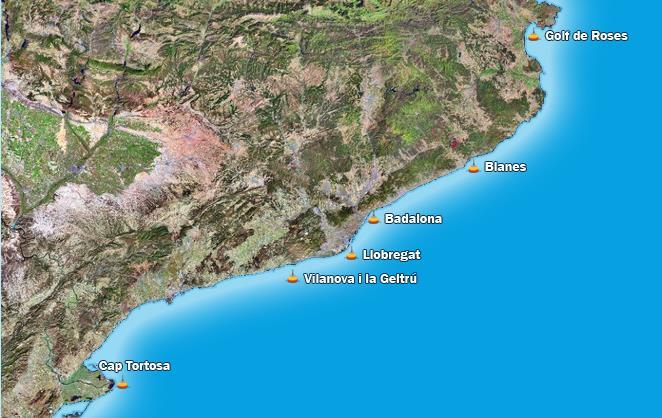
15 VALIDATION

16 Wave modelling results: DATABASE

17 Satellite data: DATABASE
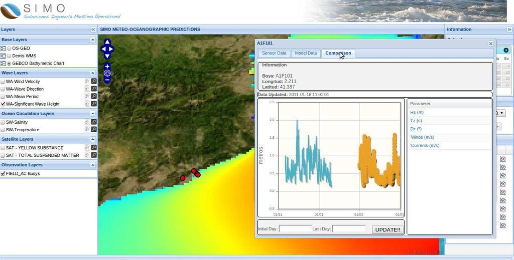
18 Comparison: DATABASE
 WMS Wave Model Meteo BC QA SOS Geo server TDS ROMS Model Ocean BC Geofeatures Land")
19 ARCHITECTURE Operational Models Internal External Posgre SQL DB User Application (JS, HTML, FLASH) WMS Wave Model Meteo BC QA SOS Geo server TDS ROMS Model Ocean BC Geofeatures Land BC
20 APPLICATIONS Using data from all the different sources, a webapplication is being developed using different javascript libraries, html code, flash applications and geoserver: - Javascript libraries: openlayers, geoext, ext.js, jquery... - Geoserver
21 FINAL END-USERS APPLICATION - Openlayers: An opensource js library to load, display and render maps from multiple sources on web pages. - Ext JS: a library for building interactive web applications using techniques such as Ajax, DHTML and DOM scripting - GeoExt: GeoExt brings together the geospatial know how of OpenLayers with the user interface savvy of Ext JS for building powerful desktop style GIS apps on the web with JavaScript.

22 FINAL END-USERS APPLICATION - Jquery: fast and concise JavaScript Library that simplifies HTML document traversing, event handling, animating, and Ajax interactions for rapid web development. - jqplot: open-source charting component that can be used to render data-driven and animated charts in web applications. - Geoserver: open source software server written in Java that allows users to share and edit geospatial data.
23 FINAL APPLICATIONS - MARINE TOWAGE COMPANY - MARINE GEOTECHNICAL COMPANY - OIL SPILL PREDICTION

24 MARINE TOWAGE COMPANY -Shipment of 25 caissons for new Harbour Terminal -Requirement of wave and wind predictions to ensure safe transport
 User requirements regarding hosting of")
25 MARINE GEOTECHNICAL COMPANY Different locations and constant changes (routes). Incorporation of buoy and simulated data (validation) User requirements regarding hosting of visualization tools

26 A new Numerical model has been developed Weathering processes incorporated Support for decision takers WebGIS application to enter data OIL SPILL PREDICTION

27 OIL SPILL PREDICTION Results can be analysed easily Possibility of incorporating different mitigation measures (work in progress)

28
Uniform Resource Locator Wide Area Network World Climate Research Programme Coupled Model Intercomparison
 Glossary API Application Programming Interface AR5 IPCC Assessment Report 4 ASCII American Standard Code for Information Interchange BUFR Binary Universal Form for the Representation of meteorological
Catalog-driven, Reproducible Workflows for Ocean Science
 Catalog-driven, Reproducible Workflows for Ocean Science Rich Signell, USGS, Woods Hole, MA, USA Filipe Fernandes, Centro Universidade Monte Serrat, Santos, Brazil. 2015 Boston Light Swim, Aug 15, 7:00am
Scientific and Multidimensional Raster Support in ArcGIS
 Scientific and Multidimensional Raster Support in ArcGIS Sudhir Raj Shrestha sshrestha@esri.com Brief breakdown Scientific Multidimensional data Ingesting Scientific MultiDim Data in ArcGIS Ingesting and
Working with Scientific Data in ArcGIS Platform
 Working with Scientific Data in ArcGIS Platform Sudhir Raj Shrestha sshrestha@esri.com Hong Xu hxu@esri.com Esri User Conference, San Diego, CA. July 11, 2017 What we will cover today Scientific Multidimensional
Oceanic Observatory for the Iberian Shelf
 Oceanic Observatory for the Iberian Shelf B.Vila Barcelona, 26th September 2016 Objectives: The Project Improve the oceanic observation at the North Western Iberian coast (meteorological, oceanographical
The GeoPortal Cookbook Tutorial
 The GeoPortal Cookbook Tutorial Wim Hugo SAEON/ SAEOS SCOPE OF DISCUSSION Background and Additional Resources Context and Concepts The Main Components of a GeoPortal Architecture Implementation Options
Online intercomparison of models and observations using OGC and community standards
 Online intercomparison of models and observations using OGC and community standards Alastair Gemmell * Jon Blower Keith Haines Adit Santokhee Reading e-science e Centre, Environmental Systems Science Centre,
OGC at KNMI: Current use and plans
 OGC at KNMI: Current use and plans 4th Workshop on the use of GIS/OGC standards in meteorology 4 th of March 2013, Reading 1. Ernst de Vreede 2. Maarten Plieger Contents 1. ADAGUC 2. Internal applications
Regarding the quality attributes, the architecture of the system must be:
 The SDSS System Overview This chapter gives an overview of the software architecture of the RiskChanges SDSS system. One of the objectives within the project is the development of a SDSS system for probabilistic
Developing data catalogue extensions for metadata harvesting in GIS
 University of Bergen Department of Informatics Developing data catalogue extensions for metadata harvesting in GIS Author: André Mossige Long master thesis June 2018 Acknowledgements I would like to thank
The Many Facets of THREDDS Thematic Real-time Environmental Distributed Data Services
 The Many Facets of THREDDS Thematic Real-time Environmental Distributed Data Services For March 2007 Unidata Policy Committee Meeting Ben Domenico 1 Motivation From the Unidata 2003 proposal: utilizing
PV Developing Apps for tempo-spatial meteorological satellite data - using OGC Services. EUMETSAT ImageGallery Key Concepts for better MapApps
 PV 2011 15-17 November 2011 CNES Toulouse, France Developing Apps for tempo-spatial meteorological satellite data - using OGC Services EUMETSAT ImageGallery Key Concepts for better MapApps Uwe Voges (con
Web Map Servers. Mark de Blois. Septembre 2016
 Web Map Servers Mark de Blois Septembre 2016 Learning Objectives After this lecture you will be able to understand web map servers as used in Web-GIS applications Introduction A Web Map Server is a computer
Python: Working with Multidimensional Scientific Data. Nawajish Noman Deng Ding
 Python: Working with Multidimensional Scientific Data Nawajish Noman Deng Ding Outline Scientific Multidimensional Data Ingest and Data Management Analysis and Visualization Extending Analytical Capabilities
Scientific Data Plat f or m
 Usi n g Ar cgis as a Scientific Data Plat f or m Feroz Kadar Sudhir Raj Shrestha Top i cs Introduction Ingesting and managing Visualizing and analyzing Disseminating and consuming The road ahead Scientific
Extension of INSPIRE Download Services TG for Observation Data
 Extension of INSPIRE Download Services TG for Observation Data Simon Jirka (52 North) 14 th June 2014, MIG Workshop on WCS-based INSPIRE Download Services Agenda Motivation Sensor Web Proposed Update for
Development of the automatic data processing system of the Instituto Español de Oceanografía surface water sampling network
 Development of the automatic data processing system of the Instituto Español de Oceanografía surface water sampling network Gonzalo González-Nuevo, Jose Manuel Cabanas, Manuel Ruiz Villarreal, Elena Tel,
SEXTANT 1. Purpose of the Application
 SEXTANT 1. Purpose of the Application Sextant has been used in the domains of Earth Observation and Environment by presenting its browsing and visualization capabilities using a number of link geospatial
Ocean, Atmosphere & Climate Model Assessment for Everyone
 Ocean, Atmosphere & Climate Model Assessment for Everyone Rich Signell USGS Woods Hole, MA Unidata 2014 DeSouza Award Presentation Boulder, CO : Sep 15, 2014 2 US Integrated Ocean Observing System (IOOS
Introduction to INSPIRE. Network Services
 Introduction to INSPIRE. Network Services European Commission Joint Research Centre Institute for Environment and Sustainability Digital Earth and Reference Data Unit www.jrc.ec.europa.eu Serving society
Leveraging OGC Services in ArcGIS Server. Satish Sankaran, Esri Yingqi Tang, Esri
 Leveraging OGC Services in ArcGIS Server Satish Sankaran, Esri Yingqi Tang, Esri GIS Creating and Managing Geo Information Products - Proprietary - Open Specifications - Standards Dissemination of Geo
Using a Sensor Observation Service (SOS) for E1a and E2a
 for E1a and E2a") Using a Sensor Observation Service (SOS) for E1a and E2a Olav Peeters Belgian Interregional Environment Agency (IRCEL CELINE) Content SOS what is this? SOS and the IPR schema Development of an IPR compliant
Using a Sensor Observation Service (SOS) for E1a and E2a Olav Peeters Belgian Interregional Environment Agency (IRCEL CELINE) Content SOS what is this? SOS and the IPR schema Development of an IPR compliant
pgrouting extends the postgis/postgresql geospatial database to provide geospatial routing and other network analysis functionality.
 Workshop: 1 pgrouting extends the postgis/postgresql geospatial database to provide geospatial routing and other network analysis functionality. Attendee s previous knowledge: SQL (PostgreSQL, PostGIS)
Lynnes, Yang, Hu, Domenico and Enloe Category: Technical Note March Interoperability between OGC CS/W and WCS Protocols
 Status of this RFC This RFC Technical Note describes a project to provide a catalog search service for the Thematic Realtime Environmental Data Distribution System (THREDDS). Specifically, the project
IMOS/AODN ocean portal: tools for data delivery. Roger Proctor, Peter Blain, Sebastien Mancini IMOS
 IMOS/AODN ocean portal: tools for data delivery Roger Proctor, Peter Blain, Sebastien Mancini IMOS Data from IMOS: The six Nodes Bluewater and Climate Node open ocean focus Five Regional Nodes continental
OPeNDAP: Accessing HYCOM (and other data) remotely
 remotely") OPeNDAP: Accessing HYCOM (and other data) remotely Presented at The HYCOM NOPP GODAE Meeting By Peter Cornillon OPeNDAP Inc., Narragansett, RI 02882 7 December 2005 8/25/05 HYCOM NOPP GODAE 1 Acknowledgements
OPeNDAP: Accessing HYCOM (and other data) remotely Presented at The HYCOM NOPP GODAE Meeting By Peter Cornillon OPeNDAP Inc., Narragansett, RI 02882 7 December 2005 8/25/05 HYCOM NOPP GODAE 1 Acknowledgements
The Integrated Data Viewer A web-enabled enabled tool for geoscientific analysis and visualization
 The Integrated Data Viewer A web-enabled enabled tool for geoscientific analysis and visualization Don Murray Unidata Program Center University Corporation for Atmospheric Research Overview Unidata Overview
CLIPC portal: driven by climate4impact.eu services
 Helping Europe respond to the impact of climate change CLIPC portal: driven by climate4impact.eu services MARIS: Peter Thijsen, Jordan Maduro, Bert Broeren, KNMI: Maarten Plieger, Ernst de Vreede, Andrej
Web Service Interface. Dr. Simon Jirka
 1 Web Service Interface Standards Dr. Simon Jirka Overview 2 Providing Access to Observation Data OGC Sensor Observation Service Controlling Sensors OGC Sensor Planning Service Event Notification SOS 3
Webservice-energy.org GEO Community Portal & Spatial Data Infrastructure for Energy
 Webservice-energy.org GEO Community Portal & Spatial Data Infrastructure for Energy Lionel Menard / Oct. 23 2017 Centre Observation, Impacts, Energy Research activities: Use of Earth observation data (Models,
Distributed Online Data Access and Analysis
 Distributed Online Data Access and Analysis Ruixin Yang George Mason University Slides from SIESIP Partners and from NOMADS PI, Glenn K. Rutledge of US NCDC on NOMADS SIESIP: Seasonal-to-Interannual Earth
Research, stakeholders and results transfer in the Pacific islands: first results of a multi-organisation project
 19th International Congress on Modelling and Simulation, Perth, Australia, 12 16 December 2011 http://mssanz.org.au/modsim2011 Research, stakeholders and results transfer in the Pacific islands: first
THE ENVIRONMENTAL OBSERVATION WEB AND ITS SERVICE APPLICATIONS WITHIN THE FUTURE INTERNET Project introduction and technical foundations (I)
") ENVIROfying the Future Internet THE ENVIRONMENTAL OBSERVATION WEB AND ITS SERVICE APPLICATIONS WITHIN THE FUTURE INTERNET Project introduction and technical foundations (I) INSPIRE Conference Firenze,
ENVIROfying the Future Internet THE ENVIRONMENTAL OBSERVATION WEB AND ITS SERVICE APPLICATIONS WITHIN THE FUTURE INTERNET Project introduction and technical foundations (I) INSPIRE Conference Firenze,
Processing and analysis of Earth Observation data
 Processing and analysis of Earth Observation data Carsten Brockmann, Brockmann Consult GmbH ESA Climate Change Initiative Toolbox Science Lead Big Data Analytics & GIS, Münster 20.-21. September 2017.
Metadata for Data Discovery: The NERC Data Catalogue Service. Steve Donegan
 Metadata for Data Discovery: The NERC Data Catalogue Service Steve Donegan Introduction NERC, Science and Data Centres NERC Discovery Metadata The Data Catalogue Service NERC Data Services Case study:
Proposed update of Technical Guidance for INSPIRE Download services based on SOS
 Proposed update of Technical Guidance for INSPIRE Download services based on SOS Organised by: Simon Jirka, Alexander Kotsev, Michael Lutz Dr. Simon Jirka (jirka@52north.org) 52 North GmbH Workshop - The
A ONE-STOP SERVICE HUB INTEGRATING ESSENTIAL WEATHER AND GEOPHYSICAL INFORMATION ON A GIS PLATFORM. Hong Kong Observatory
 A ONE-STOP SERVICE HUB INTEGRATING ESSENTIAL WEATHER AND GEOPHYSICAL INFORMATION ON A GIS PLATFORM Hong Kong Observatory Mission HONG KONG OBSERVATORY To provide people-oriented quality services in meteorology
Implementing Web GIS Solutions
 Implementing Web GIS Solutions using open source software Karsten Vennemann Seattle Talk Overview Talk Overview Why and What What is Open Source (GIS)? Why use it? Application Components Overview of Web
INTEGRATION OF DISASTER EVENT DATA INTO SPATIAL DATA INFRASTRUCTURES
 INTEGRATION OF DISASTER EVENT DATA INTO SPATIAL DATA INFRASTRUCTURES B. Stollberg a, *, T. De Groeve a, A. Hirner a, L. Vernaccini a, S. Paris a a Joint Research Centre of the European Commission, Institute
Interactive Web Mapping: Overview
 Interactive Web Mapping: Overview Overview of how geospatial data is formatted requested supplied consumed by/for web technologies 2 Definitions Analysis exploring and modeling geospatial phenomena Mapping
Making data access easier with OPeNDAP. James Gallapher (OPeNDAP TM ) Duan Beckett (BoM) Kate Snow (NCI) Robert Davy (CSIRO) Adrian Burton (ARDC)
 Duan Beckett (BoM) Kate Snow (NCI) Robert Davy (CSIRO) Adrian Burton (ARDC)") Making data access easier with OPeNDAP James Gallapher (OPeNDAP TM ) Duan Beckett (BoM) Kate Snow (NCI) Robert Davy (CSIRO) Adrian Burton (ARDC) Outline Introduction and trajectory (James Gallapher) OPeNDAP
Making data access easier with OPeNDAP James Gallapher (OPeNDAP TM ) Duan Beckett (BoM) Kate Snow (NCI) Robert Davy (CSIRO) Adrian Burton (ARDC) Outline Introduction and trajectory (James Gallapher) OPeNDAP
SDI Tecnological Components and Standards
 SDI Tecnological Components and Standards Salvador Bayarri sbayarri@gmail.com World Bank Consultant Contents The SDI architecture model Software components: the SDI stack Basic services Metadata SDI access
New Datasets, Functionality and Future Development. Ashwanth Srinivasan, (FSU) Steve Hankin (NOAA/PMEL) Major contributors: Jon Callahan (Mazama(
 Steve Hankin (NOAA/PMEL) Major contributors: Jon Callahan (Mazama(") HYCOM Data Service New Datasets, Functionality and Future Development Ashwanth Srinivasan, (FSU) Steve Hankin (NOAA/PMEL) Major contributors: Jon Callahan (Mazama( Consulting) Roland Schweitzer (Weathertop
HYCOM Data Service New Datasets, Functionality and Future Development Ashwanth Srinivasan, (FSU) Steve Hankin (NOAA/PMEL) Major contributors: Jon Callahan (Mazama( Consulting) Roland Schweitzer (Weathertop
European Marine Data Exchange
 European Marine Data Exchange By Dick M.A. Schaap MARIS (NL) EU SeaDataNet Technical Coordinator EU EMODnet Ingestion Coordinator Noordzeedagen 2018 - October 2018 Acquisition of ocean and marine data
The Butterfly Effect. A proposal for distribution and management for butterfly data programs. Dave Waetjen SESYNC Butterfly Workshop May 10, 2012
 The Butterfly Effect A proposal for distribution and management for butterfly data programs Dave Waetjen SESYNC Butterfly Workshop May 10, 2012 http://butterfly.ucdavis.edu Citizen Science based Observation
Developing a Free and Open Source Software based Spatial Data Infrastructure. Jeroen Ticheler
 Developing a Free and Open Source Software based Spatial Data Infrastructure Jeroen Ticheler 1 License This work is licensed under the Creative Commons Attribution-NonCommercial-ShareAlike 2.5 License.
NFMS web portals Focus on monitoring functions
 NFMS web portals Focus on monitoring functions National Forest Monitoring System web portal to disseminate forest-related geospatial data on the web Dr. Inge Jonckheere, FAO UN-REDD October 2014, Hanoi,
Compass INSPIRE Services. Compass INSPIRE Services. White Paper Compass Informatics Limited Block 8, Blackrock Business
 Compass INSPIRE Services White Paper 2010 Compass INSPIRE Services Compass Informatics Limited Block 8, Blackrock Business Park, Carysfort Avenue, Blackrock, County Dublin, Ireland Contact Us: +353 1 2104580
GeoNode Intro & Demo
 GeoNode Intro & Demo Cristiano Giovando - Global Facility for Disaster Reduction and Recovery, World Bank Paolo Corti - Center for Geographic Analysis, Harvard University Dynamic Mapping of Secondary Cities
Multi-Community, Multi-Sensor Maritime Earth Observation DC
 Multi-Community, Multi-Sensor Maritime Earth Observation DC How do you eat the elephant? Gianluca Luraschi EO Project Manager and Application Architect Gianluca.luraschi@emsa.europa.eu SafeSeaNet Ecosystem
HYCOM Data Service and Web Outreach
 HYCOM Data Service and Web Outreach A. Srinivasan 1, S. Hankin, P. Cornillon, and E. P. Chassignet 1 Center for Ocean-Atmospheric Prediction Studies, Florida State University phone: (850) 644-7462 fax:
Providing INSPIRE measurement data. K. Schleidt, S. Grellet, A. Sarretta, P. Tagliolato, A. Kotsev
 Providing INSPIRE measurement data K. Schleidt, S. Grellet, A. Sarretta, P. Tagliolato, A. Kotsev Part 1. Introduction Context 10 years ago o Geospatial information was hardly (if at all) exchanged in
Croatian Motorways Road Database Management System
 Croatian Motorways Road Database Management System Marko Turković FOSS4G-Europe 2014 Presentation overview About us System introduction System component architecture Kosmo Desktop WebGIS portal Future
Mobile Application Of Open Source Stack To Geo-Based Data Visualisation On E-Government Web Framework
 Free and Open Source Software for Geospatial (FOSS4G) Conference Proceedings Volume 15 Seoul, South Korea Article 18 2015 Mobile Application Of Open Source Stack To Geo-Based Data Visualisation On E-Government
OPEN SOURCE SOLUTIONS FOR SURVEYORS
 2 nd Sabah International Surveyors Congress 11 th 12 th March 2014 OPEN SOURCE SOLUTIONS FOR SURVEYORS Presented By : Sr Alexander Chong Director, Jurukur Antarabangsa The Benefits Of Closed Proprietary
Setting up the Ihlet Social Cadastre
 Setting up the Ihlet Social Cadastre Ihlet KHT Dr. Attila Molnár, GI consultant Bela Jarolics Rome, Italy TOPICS Goal of the project Architecture Database Solution Standards, communication Metadata Security
Open source technologies and INSPIRE network services in Slovak environmental agency
 Open source technologies and INSPIRE network services in Slovak environmental agency Peter Mozolík, Martin Koška, Marek Žiačik, Martin Tuchyňa Slovak Environmental Agency (SEA) SEA role within slovak SDI
Putting Your Data on the Map
 Putting Your Data on the Map Cyndy Chandler WHOI Marine Chemistry Department Woods Hole Data Mongers / Ocean Informatics Meeting 4 April 2007 - WHOI Finding the OI in WHOI What is Ocean Informatics? The
Lecture note on the history and principles of geo-webservices
 A SHORT INTRODUCTION TO GEO-WEBSERVICES Lecture note on the history and principles of geo-webservices Barend Köbben Version 1.0 February 24, 2010 Contents 1 From monolithic to distributed GIS architectures
The CEDA Web Processing Service for rapid deployment of earth system data services
 The CEDA Web Processing Service for rapid deployment of earth system data services Stephen Pascoe Ag Stephens Phil Kershaw Centre of Environmental Data Archival 1 1 Overview of CEDA-WPS History first implementation
Mapping, Visualization, and Digitization of the Geo-Referenced Information: A case study on Road Network Development in Near Real Time
 Mapping, Visualization, and Digitization of the Geo-Referenced Information: A case study on Road Network Development in Near Real Time Ronak Jain 1, Himansi Bhatt 2, Nithya Jeevanand 2, Praveen Kumar 3
Heterogeneous Missions Accessibility: Interoperability for Earth Observation
 Heterogeneous Missions Accessibility: Interoperability for Earth Observation Pier Giorgio Marchetti - European Space Agency pier.giorgio.marchetti@esa.int Slide 1 EO missions Earth Explorer Global Challenges
Using the Network Common Data Form for storage of atmospheric data
 Using the Network Common Data Form for storage of atmospheric data Maarten Plieger Royal Netherlands Meteorological Institute The NetCDF4 data format (Network Common Data Form) is used within the ADAGUC
Web GIS Development using Open Source Leaflet and Geoserver Toolkit
 Web GIS Development using Open Source Leaflet and Geoserver Toolkit 1 Taranjot Singh Bhatia, 2 Harpinder Singh, 3 P.K Litoria, 4 Brijendra Pateriya 1,2,3,4 Punjab Remote Sensing Centre, Ludhiana, Punjab,
Toward the Development of a Comprehensive Data & Information Management System for THORPEX
 Toward the Development of a Comprehensive Data & Information Management System for THORPEX Mohan Ramamurthy, Unidata Steve Williams, JOSS Jose Meitin, JOSS Karyn Sawyer, JOSS UCAR Office of Programs Boulder,
Air Quality & e-reporting from the perspective of Belgium
 Air Quality & e-reporting from the perspective of Belgium Olav Peeters Belgian Interregional Environment Agency (IRCEL CELINE) Content Who are we (IRCEL CELINE) and what do we do? E-reporting from our
Data discovery and access via the SeaDataNet CDI system
 Data discovery and access via the SeaDataNet CDI system Central dataproducts and data services on distributed data. Peter Thijsse MARIS CLIPC IS-ENES workshop, KNMI, November 2014 Outline 1. Introduction
Development of Java Plug-In for Geoserver to Read GeoRaster Data. 1. Baskar Dhanapal CoreLogic Global Services Private Limited, Bangalore
 Development of Java Plug-In for Geoserver to Read GeoRaster Data 1. Baskar Dhanapal CoreLogic Global Services Private Limited, Bangalore 2. Bruce Thelen CoreLogic Spatial Solutions, Austin, USA 3. Perumal
Spatial Data on the Web
 Spatial Data on the Web Tools and guidance for data providers The European Commission s science and knowledge service W3C Data on the Web Best Practices 35 W3C/OGC Spatial Data on the Web Best Practices
METAINFORMATION INFRASTRUCTURE FOR GEOSPATIAL INFORMATION
 2010/2 PAGES 1 7 RECEIVED 15. 6. 2009 ACCEPTED 2. 3. 2010 T. KLIMENT METAINFORMATION INFRASTRUCTURE FOR GEOSPATIAL INFORMATION ABSTRACT Tomáš KLIMENT email: tomas.kliment@stuba.sk Research field: Spatial
The Common Framework for Earth Observation Data. US Group on Earth Observations Data Management Working Group
 The Common Framework for Earth Observation Data US Group on Earth Observations Data Management Working Group Agenda USGEO and BEDI background Concise summary of recommended CFEOD standards today Full document
_ LUCIADFUSION V PRODUCT DATA SHEET _ LUCIADFUSION PRODUCT DATA SHEET
 _ LUCIADFUSION PRODUCT DATA SHEET V2016 LuciadFusion is the solution for efficient and effective use of geospatial data. It allows you to organize your data so that each user has one-click access to a
Work Package 5. Strengthening common analysis and planning tools. Leader: HCMR
 Work Package 5 Strengthening common analysis and planning tools Leader: HCMR Leonidas Perivoliotis Institute of Oceanography, HCMR Rome, 3 rd st Steering committee meeting 12-13 September 2012 PORTico-
InCLUDE Data Exchange. Julia Harrell, GISP GIS Coordinator, NC DENR
 InCLUDE Data Exchange Julia Harrell, GISP GIS Coordinator, NC DENR Julia.harrell@ncdenr.gov InCLUDE Project Partners NC Department of Environment & Natural Resources: The State of NC s lead environmental
Case Study #2: A DSS for Flash Flood
 S. Nativi, P. Mazzetti, L. Bigagli and M. Mancini Case Study #2: A DSS for Flash Flood Bringing together Geo-science systems and Decision Makers Ontology mapping issue Expanding Horizons 2003 UNIDATA/UCAR
RESOURCE ATLAS OVER THE WEB: PRELIMINARY RESULTS
 DISSEMINATION OF THE UAE SOLAR RESOURCE ATLAS OVER THE WEB: PRELIMINARY RESULTS and Research Center for Renewable Energy Mapping and Assessment Masdar Institute of Science and Technology, Abu Dhabi, United
The Logical Data Store
 Tenth ECMWF Workshop on Meteorological Operational Systems 14-18 November 2005, Reading The Logical Data Store Bruce Wright, John Ward & Malcolm Field Crown copyright 2005 Page 1 Contents The presentation
ASTROWEB ASTROINFORMATICS PROJECT AND COMPARISON OF THE WEB-GIS PROTOCOL STANDARDS
 Proceedings of the IX Bulgarian-Serbian Astronomical Conference: Astroinformatics (IX BSACA) Sofia, Bulgaria, July 2-4, 2014, Editors: M. K. Tsvetkov, M. S. Dimitrijević, O. Kounchev, D. Jevremović and
1.1 INTRODUCTION 1.2 HARDWARE AND SOFTWARE SPECIFICATIONS. Hardware - Processor (two quad core processors) with 32GB RAM, 5 x146gb RAID hard drive
 with 32GB RAM, 5 x146gb RAID hard drive") 1.1 INTRODUCTION This chapter deals with the type of hardware that is used and the software to support the same. Selection and identification of suitable software is also taken into account. Connectivity
1.1 INTRODUCTION This chapter deals with the type of hardware that is used and the software to support the same. Selection and identification of suitable software is also taken into account. Connectivity
OSGeo Web Mapping Typification: GeoMajas, Mapbender, MapFish and OpenLayers. Christoph Baudson Arnulf Christl FOSS4G 2010 Barcelona
 OSGeo Web Mapping Typification: GeoMajas, Mapbender, MapFish and OpenLayers Christoph Baudson Arnulf Christl FOSS4G 2010 Barcelona Disclaimer All information contained in this presentation has been compiled
Steve Ansari *, Stephen Del Greco, Neal Lott NOAA National Climatic Data Center, Asheville, North Carolina 2. DATA
 5A.1 THE WEATHER AND CLIMATE TOOLKIT Steve Ansari *, Stephen Del Greco, Neal Lott NOAA National Climatic Data Center, Asheville, North Carolina ABSTRACT The Weather and Climate Toolkit (WCT) is free, platform
SCSODC: Integrating Ocean Data for Visualization Sharing and Application
 IOP Conference Series: Earth and Environmental Science OPEN ACCESS SCSODC: Integrating Ocean Data for Visualization Sharing and Application To cite this article: C Xu et al 2014 IOP Conf. Ser.: Earth Environ.
Earth Observation Services in Collaborative Platforms
 Earth Observation Services in Collaborative Platforms Elecnor Deimos Overview Elecnor DEIMOS: the technology branch of ELECNOR Space is core business, with spillovers to Aerospace, Defense, Transport,
Exploring Open Source GIS Programming. Scott Parker, Katie Urey, Jack Newlevant, Mele Sax-Barnett
 Exploring Open Source GIS Programming Scott Parker, Katie Urey, Jack Newlevant, Mele Sax-Barnett When to write a program When you expect your tool to have multiple uses and/or multiple iterations Something
Managing Scientific Data Efficiently in a DBMS
 Introduced by: Presented by: Managing Scientific Data Efficiently in a DBMS Christine D Angela (IBM Corporation) Ian Barrodale (Barrodale Computing Services - BCS) and Robert Uleman (IBM Corporation) Date:02/18/2009
DATA SHARING AND DISCOVERY WITH ARCGIS SERVER GEOPORTAL EXTENSION. Clive Reece, Ph.D. ESRI Geoportal/SDI Solutions Team
 DATA SHARING AND DISCOVERY WITH ARCGIS SERVER GEOPORTAL EXTENSION Clive Reece, Ph.D. ESRI Geoportal/SDI Solutions Team Geoportal Extension for ArcGIS Server Context within an Enterprise Spatial Data Infrastructure
Leveraging OGC Standards on ArcGIS Server
 Leveraging OGC Standards on ArcGIS Server Satish Sankaran Interoperability and Standards Team James Michel III ESRI Intel Team ArcGIS Server Complete Interoperable Server-Based GIS Desktop Explorer Web
The Integrated Data Viewer A Tool for Scientific Analysis and Visualization
 The Integrated Data Viewer A Tool for Scientific Analysis and Visualization Don Murray Unidata Program Center Overview What is the Integrated Data Viewer (IDV)? IDV features Web enabled features Client/Server
Achieving Interoperability using the ArcGIS Platform. Satish Sankaran Roberto Lucchi
 Achieving Interoperability using the ArcGIS Platform Satish Sankaran Roberto Lucchi Thank you Please fill out the session survey in your mobile app Select [Achieving Interoperability using the ArcGIS Platform]
International Organization for Standardization Technical Committee 211 (ISO/TC211)
") Esri Support for Geospatial Standards: Open Geospatial Consortium (OGC) International Organization for Standardization Technical Committee 211 (ISO/TC211) An Esri White Paper April 2015 Copyright 2015
Esri Support for Geospatial Standards: Open Geospatial Consortium (OGC) International Organization for Standardization Technical Committee 211 (ISO/TC211) An Esri White Paper April 2015 Copyright 2015
From Synergie and Oppidum to Synopsis
 From Synergie and Oppidum to Synopsis M.-F. VOIDROT & A. LASSERRE-BIGORRY EGOWS Meeting ECMWF, June 2010 2 Overview Synergie and Oppidum : Two operational tools for forecasting at Meteo-France (and web
From Geoportal to Spatial Data Service Platform. Jani Kylmäaho National Land Survey of Finland Development Centre
 From Geoportal to Spatial Data Service Platform Jani Kylmäaho National Land Survey of Finland Development Centre Introduction National Land Survey of Finland - 1900 employees Development Centre - 120 employees
Introduction THE OPENGEO ARCHITECTURE
 Introduction Putting maps on the web used to be very very difficult. It required specialized software, and more important, specialized knowledge about the kinds of data and processes used to create cartographic
SERVO - ACES Abstract
 1 of 6 12/27/2004 2:33 PM 2 of 6 12/27/2004 2:33 PM Implementing GIS Grid Services for the International Solid Earth Research Virtual Observatory Galip Aydin (1), Marlon Pierce (1), Geoffrey Fox (1), Mehmet
CF-netCDF and CDM. Ethan Davis, John Caron, Ben Domenico, Stefano Nativi* UCAR Unidata Univ of Florence*
 CF-netCDF and CDM Ethan Davis, John Caron, Ben Domenico, Stefano Nativi* UCAR Unidata Univ of Florence* OGC in MetOcean, Toulouse, France, November 2009 CF-netCDF and CDM CF-netCDF CDM/netCDF-java TDS
Etanova Enterprise Solutions
 Etanova Enterprise Solutions Front End Development» 2018-09-23 http://www.etanova.com/technologies/front-end-development Contents HTML 5... 6 Rich Internet Applications... 6 Web Browser Hardware Acceleration...
Building Virtual Earth Observatories Using Scientific Database, Semantic Web and Linked Geospatial Data Technologies
 Building Virtual Earth Observatories Using Scientific Database, Semantic Web and Linked Geospatial Data Technologies Presenter: George Garbis ggarbis@di.uoa.gr Dept. of Informatics and Telecommunications
InCLUDE Data Exchange. Julia Harrell, GISP GIS Coordinator, NC DENR
 InCLUDE Data Exchange Julia Harrell, GISP GIS Coordinator, NC DENR Julia.harrell@ncdenr.gov InCLUDE Project Partners NC Department of Environment & Natural Resources: The State of NC s lead environmental
Welcome to the Introduction to Mapbender
 0 Welcome to the Introduction to Mapbender Author: Astrid Emde Author: Christoph Baudson Version: 1.0 License: Creative Commons Date: 2010-08-30 1 Table of Contents 1 Project Overview 2 1.1 Geoportal Framework
CMEMS Service Evolution 21-SE-CALL1. Recommendation and guideline to set up the hardware and software tools to provide HFR data to the HFR Node
 CMEMS Service Evolution 21-SE-CALL1 Recommendation and guideline to set up the hardware and software tools to provide HFR data to the HFR Node July26th, 2017 1 FOREWORD This document is the first version