CSIRO and the Open Data Cube
|
|
|
- Lucas Sanders
- 6 years ago
- Views:
Transcription

1 CSIRO and the Open Data Cube Dr Robert Woodcock, Matt Paget, Peter Wang, Alex Held CSIRO
2 Overview The challenge The Earth Observation Data Deluge Integrated science needs Data volume, rate of growth and variety User expectations Meeting the challenge, responding to change The EOI ecosystem Community and capacity building The Australian Geoscience Data Cube What it is / how it works


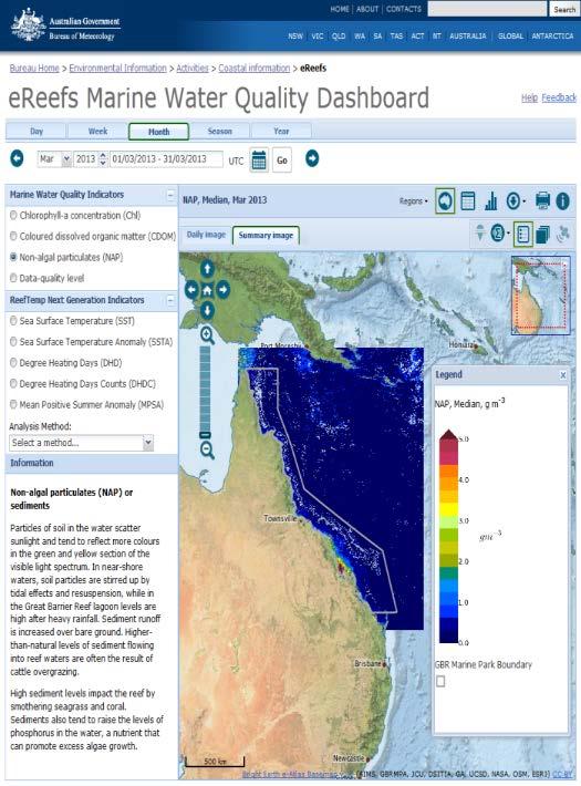
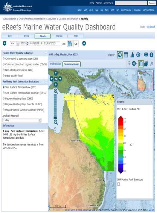
3 ereefs Marine Water Quality Dashboard


4 Collaborators: Thomas Schroeder, Arnold Dekker, David Blondeau-Patissier, Kadija Oubelkheir, Nagur Cherukuru, Lesley Clementson, Paul Daniel, Janet Anstee, Britta Schaffelke, Michelle Devlin OCEANS AND ATMOSPHERE

5 ...estimated annual average sediment load reducing by 11 per cent overall


6 Recognise the complete picture...

7 The growing expectations of users Increasing need for: richer content personalised tools better filtering diverse content from multiple sources Anywhere, anytime, any device, on-demand How do I connect my tools to your content?


8 Acquisition to Products Data Access public good & industry? instrument development partnerships Reduction to Reflectance/ Emittance/ Backscattering vicarious calibration atmospheric effects Information Extraction data volumes DD fusion/md fusion/mda libraries (standards) mixing accuracy (standards) Access data volumes web access metadata Information Products climate exploration & mining environment Agriculture, forestry aquaculture Outputs instruments Data access relationship agreements Outputs methods software publications Outputs product standards methods software publications Outputs web portal? metadata standards Outputs mineral, agriculture, forestry, carbon and environmental maps tech transfer Open Data Cube Diagram inspired by Dr Cindy Ong

")
9 Data Cube - External Interfaces (Concept)

10 UI & Application Layer Data Cube Notional Architecture Forest Economics App N Integrating Tool Application / GIS Mobile App Data & Application Platform Virtual Lab Platform Business Processes (Data Management, Access Controls, Job Management, Etc.) Authentication, Authorisation, Accounting Data Cube Infrastructure Task Execution Discovery Reporting Web Services Visualization Analytical Task Definition N-Dimensional Array Interface Storage Query and Access Module Ingester (ARD and Result) Data Collection 1 Data Collection 2 Index Store Index Store Multi- Dimensional Data Data Storage Unit Multi- Dimensional Data Data Storage Unit Data Acquisition & Inflow Observations Analysis Ready Data


11 Flow Diagram - Prototype

12 N-dimensional Array Interface Python, Numpy, xarray User specifies: Data to analyse Analysis function Resources to use Execution engine/workflows distribute the computation
 Spatial alignment and consistent calibration makes analysis much simpler Every unique observation is kept and included for analysis creating dense")
13 Simple data structures and analysis Dice and Stack Can reproject on demand as well by indexing existing files Calibrated to surface reflectance observations (CARD4L) Spatial alignment and consistent calibration makes analysis much simpler Every unique observation is kept and included for analysis creating dense timeseries
14 Storage - Files, Formats, Databases, Objects ODC supports: Files Multiple file formats via GDAL (eg. GeoTif, NetCDF) Can be on a file system or at the end of a HTTP (e.g. AWS S3 end point) Multi-dimensional files (for those that support it NetCDF) Space, Time, Bands, Masks, attributes - configurable Tends towards single Time per file but can (have!) run into limits on file system at scale Native S3 driver - objects on AWS No files -> objects are sparse arrays No limit to number of files (there is a limit but it is astronomical) More cost effective on AWS than EBS (normal file system) storage Scales like S3 does Parallel IO
15 S3

 of main memory; 10 PBytes (approx.")
 Parallel IO")
16 Deployment to HPC, Cloud, PC National Computational Infrastructure 57,472 cores (2.6 GHz) in 3592 compute nodes; 160 TBytes (approx.) of main memory; 10 PBytes (approx.) of usable fast file system (for short-term scratch space). Cloud AWS EC2 and S3 S3 native IO (no files) Parallel IO Elastically scalable Serverless? - AWS Lambda CSIRO Earth Analytics Industry Innovation Hub
17 Data-Intensive Quantitative EO Science The Open Data Cube (ODC) : supports the management and quantitative analysis of massive volumes of Earth observation (EO) and other geoscientific data. EO data are: calibrated to surface reflectance observations, organised as regular geographic tiles rather than scenes or images, Co-located high performance data (HPD) and high performance compute (HPC) at national facility for continental/global scale Cloud and PC portable for alternate needs (industry, elasticity) This approach positions the ODC to become a sensor-independent system for management, analysis and sharing of EO data from workbench science to continental and production scale analysis
Pangeo. A community-driven effort for Big Data geoscience
 Pangeo A community-driven effort for Big Data geoscience !2 What would you like to have and why? Pangeo s vision for scientific computing in the big-data era Pangeo s Website pangeo-data.org !3 Hello!
DIGITAL EARTH AUSTRALIA AND OPEN DATA CUBE TRAINING WORKSHOP
 DIGITAL EARTH AUSTRALIA AND OPEN DATA CUBE TRAINING WORKSHOP VIEW, ACCESS AND ANALYSE DATA Authors: Alex Leith, Felix Lipkin and Jess Keysers Document Control Date: 29 March 2019 Version: 1.1 (FINAL) Review:
Clare Richards, Benjamin Evans, Kate Snow, Chris Allen, Jingbo Wang, Kelsey A Druken, Sean Pringle, Jon Smillie and Matt Nethery. nci.org.
 The important role of HPC and data-intensive infrastructure facilities in supporting a diversity of Virtual Research Environments (VREs): working with Climate Clare Richards, Benjamin Evans, Kate Snow,
Digital Earth Australia: First Look
 Digital Earth Australia: First Look Contact: dea@frontiersi.com.au FRONTIERSI.COM.AU OUTLINE Phil Delaney and Eva Rodriguez 2 dea@frontiersi.com.au AGENDA Time Content Presenter 12:00 Introduction Phil
Implementing a Data Quality Strategy to simplify access to data
 Implementing a Quality Strategy to simplify access to data Kelsey Druken Implementing a Quality Strategy to simplify access to data Kelsey Druken, Claire Trenham, Lesley Wyborn, Ben Evans National Computational
Implementing a Data Quality Strategy to simplify access to data
 IN43D-07 AGU Fall Meeting 2016 Implementing a Quality Strategy to simplify access to data Kelsey Druken, Claire Trenham, Ben Evans, Clare Richards, Jingbo Wang, & Lesley Wyborn National Computational Infrastructure,
Catapult Open. The Open Data Cube (ODC) A tool to increase the value and impact of global Earth observation satellite data
 A tool to increase the value and impact of global Earth observation satellite data") The Open Data Cube (ODC) A tool to increase the value and impact of global Earth observation satellite data SATELLITE APPLICATIONS CATAPULT Our Mission // To innovate for a better world, empowered by satellites.
The Open Data Cube (ODC) A tool to increase the value and impact of global Earth observation satellite data SATELLITE APPLICATIONS CATAPULT Our Mission // To innovate for a better world, empowered by satellites.
eresearch Collaboration across the Pacific:
 eresearch Collaboration across the Pacific: Marine Systems and Australian Marine Science Craig Johnson University of Tasmania Outline Introduce the Australian Ocean Network Possibilities for trans-pacific
Pangeo. A community-driven effort for Big Data geoscience
 Pangeo A community-driven effort for Big Data geoscience !2 What Drives Progress in GEOScience? q soil New Ideas 8 < q rain2q ix2q sx z50 liq;z 5 @w : 2K soil @z 1Ksoil z > 0 New Observations New Simulations
Cyberinfrastructure Framework for 21st Century Science & Engineering (CIF21)
") Cyberinfrastructure Framework for 21st Century Science & Engineering (CIF21) NSF-wide Cyberinfrastructure Vision People, Sustainability, Innovation, Integration Alan Blatecky Director OCI 1 1 Framing the
Cyberinfrastructure Framework for 21st Century Science & Engineering (CIF21) NSF-wide Cyberinfrastructure Vision People, Sustainability, Innovation, Integration Alan Blatecky Director OCI 1 1 Framing the
 dan.fay@microsoft.com Scientific Data Intensive Computing Workshop 2004 Visualizing and Experiencing E 3 Data + Information: Provide a unique experience to reduce time to insight and knowledge through
escience in the Cloud Dan Fay Director Earth, Energy and Environment
 escience in the Cloud Dan Fay Director Earth, Energy and Environment dan.fay@microsoft.com New ways to analyze and communicate data EOS Article: Mountain Hydrology, Snow Color, and the Fourth Paradigm
Data-Intensive Workflows A journey to a Holistic Framework for Data-Intensive Workflows
 Data-Intensive Workflows A journey to a Holistic Framework for Data-Intensive Workflows Ian Corner Design and Implementation Lead May 2016 INFORMATION MANAGEMENT AND TECHNOLOGY (IMT) CSIRO Who we are Commonwealth
escience in the Cloud: A MODIS Satellite Data Reprojection and Reduction Pipeline in the Windows
 escience in the Cloud: A MODIS Satellite Data Reprojection and Reduction Pipeline in the Windows Jie Li1, Deb Agarwal2, Azure Marty Platform Humphrey1, Keith Jackson2, Catharine van Ingen3, Youngryel Ryu4
DATA SHEET AlienVault USM Anywhere Powerful Threat Detection and Incident Response for All Your Critical Infrastructure
 DATA SHEET AlienVault USM Anywhere Powerful Threat Detection and Incident Response for All Your Critical Infrastructure AlienVault USM Anywhere accelerates and centralizes threat detection, incident response,
Genomics on Cisco Metacloud + SwiftStack
 Genomics on Cisco Metacloud + SwiftStack Technology is a large component of driving discovery in both research and providing timely answers for clinical treatments. Advances in genomic sequencing have
Mathematics and Computer Science Division. Department of Agricultural and Biological Engineering
 Mathematics and Computer Science Division Department of Science and Technologies University of Naples Parthenope FACE-IT: Earth science workflows made easy with Globus and Galaxy technologies (Provide
The Earth-Observation Image Librarian (EOLib): The data mining component of the TerraSAR-X Payload Ground Segment
: The data mining component of the TerraSAR-X Payload Ground Segment") The Earth-Observation Image Librarian (EOLib): The data mining component of the TerraSAR-X Payload Ground Segment Daniela Espinoza Molina, Vlad Manilici, Octavian Dumitru, Christoph Reck, Shiyong Cui,
The Earth-Observation Image Librarian (EOLib): The data mining component of the TerraSAR-X Payload Ground Segment Daniela Espinoza Molina, Vlad Manilici, Octavian Dumitru, Christoph Reck, Shiyong Cui,
C3S Data Portal: Setting the scene
 C3S Data Portal: Setting the scene Baudouin Raoult Baudouin.raoult@ecmwf.int Funded by the European Union Implemented by Evaluation & QC function from European commission e.g.,fp7 Space call Selected set
High Performance Data Efficient Interoperability for Scientific Data
 High Performance Data Efficient Interoperability for Scientific Data Alex Ip 1, Andrew Turner 1, Dr. David Lescinsky 1 1 Geoscience Australia, Canberra, Australia Problem: Legacy Data Formats holding us
Next GEOSS der neue europäische GEOSS Hub
 DLR.de Folie 1 27.10.2016, Oberpfaffenhofen Next GEOSS der neue europäische GEOSS Hub J. Meyer-Arnek, A. Müller, G. Schreier DLR.de Folie 2 NextGEOSS-Konsortium Kick-Off: 16-18 JAN 2017 Project duration:
Unidata and data-proximate analysis and visualization in the cloud
 Unidata and data-proximate analysis and visualization in the cloud Mohan Ramamurthy and Many Unidata Staff 1 June 2017 Modeling in the Cloud Workshop Unidata: A program of the community, by the community,
Lesson 14: Cloud Computing
 Yang, Chaowei et al. (2011) 'Spatial cloud computing: how can the geospatial sciences use and help shape cloud computing?', International Journal of Digital Earth, 4: 4, 305 329 GEOG 482/582 : GIS Data
Pervasive DataRush TM
 Pervasive DataRush TM Parallel Data Analysis with KNIME www.pervasivedatarush.com Company Overview Global Software Company Tens of thousands of users across the globe Americas, EMEA, Asia ~230 employees
AWS IoT Overview. July 2016 Thomas Jones, Partner Solutions Architect
 AWS IoT Overview July 2016 Thomas Jones, Partner Solutions Architect AWS customers are connecting physical things to the cloud in every industry imaginable. Healthcare and Life Sciences Municipal Infrastructure
Raster Analytics in Image Server: An Introduction. Mike Muller
 Raster Analytics in Image Server: An Introduction Mike Muller Introduction and Context The ArcGIS Platform and ArcGIS Image Server enable access to imagery and analysis through a wide range of integrated
ArcGIS Enterprise: An Introduction. Philip Heede
 Enterprise: An Introduction Philip Heede Online Enterprise Hosted by Esri (SaaS) - Upgraded automatically (by Esri) - Esri controls SLA Core Web GIS functionality (Apps, visualization, smart mapping, analysis
The Cambridge Bio-Medical-Cloud An OpenStack platform for medical analytics and biomedical research
 The Cambridge Bio-Medical-Cloud An OpenStack platform for medical analytics and biomedical research Dr Paul Calleja Director of Research Computing University of Cambridge Global leader in science & technology
IMAGERY FOR ARCGIS. Manage and Understand Your Imagery. Credit: Image courtesy of DigitalGlobe
 IMAGERY FOR ARCGIS Manage and Understand Your Imagery Credit: Image courtesy of DigitalGlobe 2 ARCGIS IS AN IMAGERY PLATFORM Empowering you to make informed decisions from imagery and remotely sensed data
Co-ReSyF Hands-on sessions
 This project has received funding from the European Union s Horizon 2020 Research and Innovation Programme under grant agreement no 687289 Co-ReSyF Hands-on sessions Coastal Waters Research Synergy Framework
Please give me your feedback
 #HPEDiscover Please give me your feedback Session ID: B4385 Speaker: Aaron Spurlock Use the mobile app to complete a session survey 1. Access My schedule 2. Click on the session detail page 3. Scroll down
Advances in GIS help create Smarter Communities
 Advances in GIS help create Smarter Communities POP(ovich) Quiz Who is a Desktop User? Who is an ArcGIS Online User? Who is a ArcGIS Server Admin? Who is a Programmer? Who works with or for a government
IMOS/AODN ocean portal: tools for data delivery. Roger Proctor, Peter Blain, Sebastien Mancini IMOS
 IMOS/AODN ocean portal: tools for data delivery Roger Proctor, Peter Blain, Sebastien Mancini IMOS Data from IMOS: The six Nodes Bluewater and Climate Node open ocean focus Five Regional Nodes continental
Uniform Resource Locator Wide Area Network World Climate Research Programme Coupled Model Intercomparison
 Glossary API Application Programming Interface AR5 IPCC Assessment Report 4 ASCII American Standard Code for Information Interchange BUFR Binary Universal Form for the Representation of meteorological
AWS & Intel: A Partnership Dedicated to fueling your Innovations. Thomas Kellerer BDM CSP, Intel Central Europe
 AWS & Intel: A Partnership Dedicated to fueling your Innovations Thomas Kellerer BDM CSP, Intel Central Europe The Digital Service Economy Growth in connected devices enables new business opportunities
Cloud scaling of Visual Weather
 Cloud scaling of Visual Weather Jozef Matula CTO 1 EGOWS Reading, United Kingdom, 15 th -17 th October 2018 Cloud - Separation of responsibilities 2 https://blogs.technet.microsoft.com/yungchou/2010/11/15/cloud-computing-primer-for-it-pros/
Cumulus Services Working Group. Dan Pilone SE TIM / August 2017
 Cumulus Services Working Group Dan Pilone dan@element84.com SE TIM / August 2017 2 Reminder: Why are we doing this? 3 Background: Motivation for Cloud Growth of Mission Data & Processing: Projected rapid
SEXTANT 1. Purpose of the Application
 SEXTANT 1. Purpose of the Application Sextant has been used in the domains of Earth Observation and Environment by presenting its browsing and visualization capabilities using a number of link geospatial
THE GEOSPATIAL DATA CLOUD: AN IMPLEMENTATION OF APPLYING CLOUD COMPUTING IN GEOSCIENCES*
 THE GEOSPATIAL DATA CLOUD: AN IMPLEMENTATION OF APPLYING CLOUD COMPUTING IN GEOSCIENCES* Xuezhi Wang 1*, Jianghua Zhao 1, Yuanchun Zhou 1, Jianhui Li 1 1 Scientific Data Center, Computer Network Information
Azure DevOps. Randy Pagels Intelligent Cloud Technical Specialist Great Lakes Region
 Azure DevOps Randy Pagels Intelligent Cloud Technical Specialist Great Lakes Region What is DevOps? People. Process. Products. Build & Test Deploy DevOps is the union of people, process, and products to
CSIRO Visualisation Service
 CSIRO Visualisation Service Assessment and Future Plans Justin Baker Visualisation and Collaboration Manager 31 August2012 IMT ERESEARCH PROGRAM CSIRO eresearch Program Research Planning eresearch Planning
DIVER and ERMA: Data and Visualization
 DIVER and ERMA: Data and Visualization DWH Long Term Data Management June 7 8, 2017 Ben Shorr (presenting) Dr. Amy Merten, Marti McGuire, Mike Peccini, Jamey Redding Nick Eckhardt, Jay Coady, Michele Jacobi,
The NCI High Performance Computing (HPC) and High Performance Data (HPD) Platform to Support the Analysis of Petascale Environmental Data Collections
 and High Performance Data (HPD) Platform to Support the Analysis of Petascale Environmental Data Collections") ESSI 2015-8273 The NCI High Performance Computing (HPC) and High Performance Data (HPD) Platform to Support the Analysis of Petascale Environmental Data Collections Ben Evans 1, Lesley Wyborn 1, Tim Pugh
ESSI 2015-8273 The NCI High Performance Computing (HPC) and High Performance Data (HPD) Platform to Support the Analysis of Petascale Environmental Data Collections Ben Evans 1, Lesley Wyborn 1, Tim Pugh
DANUBIUS-RI, the pan-european distributed research infrastructure supporting interdisciplinary research on river-sea systems
 DANUBIUS-RI, the pan-european distributed research infrastructure supporting interdisciplinary research on river-sea systems Dr. Adrian Stanica, DANUBIUS-RI ESFRI Project Coordinator www.danubius-ri.eu
Overview of the EnMAP Imaging Spectroscopy Mission
 Overview of the EnMAP Imaging Spectroscopy Mission L. Guanter, H. Kaufmann, K. Segl, S. Foerster, T. Storch, A. Mueller, U. Heiden, M. Bachmann, G. Rossner, C. Chlebek, S. Fischer, B. Sang, the EnMAP Science
ARCHITECTING WEB APPLICATIONS FOR THE CLOUD: DESIGN PRINCIPLES AND PRACTICAL GUIDANCE FOR AWS
 ARCHITECTING WEB APPLICATIONS FOR THE CLOUD: DESIGN PRINCIPLES AND PRACTICAL GUIDANCE FOR AWS Dr Adnene Guabtni, Senior Research Scientist, NICTA/Data61, CSIRO Adnene.Guabtni@csiro.au EC2 S3 ELB RDS AMI
Image Analysis With the Definiens Software Suite
 Image Analysis With the Definiens Software Suite Definiens Enterprise Image Intelligence Andreas Kühnen, Senior Sales Manager Malte Sohlbach, Systems Engineering Manager August 2009 Definiens AG 1986 Prof.
INSPIRE & Environment Data in the EU
 INSPIRE & Environment Data in the EU Andrea Perego Research Data infrastructures for Environmental related Societal Challenges Workshop @ pre-rda P6 Workshops, Paris 22 September 2015 INSPIRE in a nutshell
BROCADE CLOUD-OPTIMIZED NETWORKING: THE BLUEPRINT FOR THE SOFTWARE-DEFINED NETWORK
 BROCADE CLOUD-OPTIMIZED NETWORKING: THE BLUEPRINT FOR THE SOFTWARE-DEFINED NETWORK Ken Cheng VP, Service Provider and Application Delivery Products September 12, 2012 Brocade Cloud-Optimized Networking
Eight Tips for Better Archives. Eight Ways Cloudian Object Storage Benefits Archiving with Veritas Enterprise Vault
 Eight Tips for Better Email Archives Eight Ways Cloudian Object Storage Benefits Email Archiving with Veritas Enterprise Vault Most organizations now manage terabytes, if not petabytes, of corporate and
Integrated and Hyper-converged Data Protection
 Integrated and Hyper-converged Data Protection Ahmed Fouad Advisory Systems Engineer GLOBAL SPONSORS Agenda Dell EMC Data Protection portfolio Business and technology landscape Customer challenges in data
Nuclias by D-Link is a complete cloud-managed networking solution for small to medium-sized organisations with one or more sites.
 Nuclias by D-Link is a complete cloud-managed networking solution for small to medium-sized organisations with one or more sites. Simpler to install and easier to manage How it works Wi-Fi coverage and
Integrated and Hyper-converged Data Protection
 Integrated and Hyper-converged Data Protection Simplicity & Agility GLOBAL SPONSORS Data Protection Portfolio Protection and recovery to cloud PROTECTION STORAGE PROTECTION SOFTWARE PROTECTION APPLIANCE
European Space Policy
 European Space Policy Eleni Paliouras, ESA EuroGeographics General Assembly 3 October 2017 Vienna, Austria ESA UNCLASSIFIED - For Official Use ESA facts and figures Intergovernmental agency of 22 Member
How to Route Internet Traffic between A Mobile Application and IoT Device?
 Whitepaper How to Route Internet Traffic between A Mobile Application and IoT Device? Website: www.mobodexter.com www.paasmer.co 1 Table of Contents 1. Introduction 3 2. Approach: 1 Uses AWS IoT Setup
Global Monitoring for Environment and Security
 Global Monitoring for Environment and Security Final Report for the GMES Initial Period (2001-2003) Version 3.5 1 The GMES initiative was launched in May 1998 in Baveno and adopted by the ESA and EU Councils
Working with Scientific Data in ArcGIS Platform
 Working with Scientific Data in ArcGIS Platform Sudhir Raj Shrestha sshrestha@esri.com Hong Xu hxu@esri.com Esri User Conference, San Diego, CA. July 11, 2017 What we will cover today Scientific Multidimensional
the steps that IS Services should take to ensure that this document is aligned with the SNH s KIMS and SNH s Change Requirement;
 Shaping the Future of IS and ICT in SNH: 2014-2019 SNH s IS/ICT Vision We will develop the ICT infrastructure to support the business needs of our customers. Our ICT infrastructure and IS/GIS solutions
VMware Cloud on AWS Technical Deck VMware, Inc.
 VMware Cloud on AWS Technical Deck # 2 Enterprise Adoption Driving Strong Growth of Public Cloud Infrastructure as a Service, According to IDC. Press release. IDC. July 14, 2016 3 Cloud Building Challenges
Python: Working with Multidimensional Scientific Data. Nawajish Noman Deng Ding
 Python: Working with Multidimensional Scientific Data Nawajish Noman Deng Ding Outline Scientific Multidimensional Data Ingest and Data Management Analysis and Visualization Extending Analytical Capabilities
Hosted Azure for your business. Build virtual servers, deploy with flexibility, and reduce your hardware costs with a managed cloud solution.
 Hosted Azure for your business Build virtual servers, deploy with flexibility, and reduce your hardware costs with a managed cloud solution. Azure is approximately 50 percent cheaper than other cloud services
Zombie Apocalypse Workshop
 Zombie Apocalypse Workshop Building Serverless Microservices Danilo Poccia @danilop Paolo Latella @LatellaPaolo September 22 nd, 2016 2015, Amazon Web Services, Inc. or its Affiliates. All rights reserved.
AWIPS Technology Infusion Darien Davis NOAA/OAR Forecast Systems Laboratory Systems Development Division April 12, 2005
 AWIPS Technology Infusion Darien Davis NOAA/OAR Forecast Systems Laboratory Systems Development Division Plans for AWIPS Next Generation 1 What s a nice lab like you, doing in a place like this? Plans
NorStore. a national infrastructure for scientific data. Andreas O Jaunsen UNINETT Sigma as
 NorStore a national infrastructure for scientific data Andreas O Jaunsen UNINETT Sigma as About UNINETT Sigma UNINETT Sigma AS is a private company established by the Ministry of science and education
THE ENVIRONMENTAL OBSERVATION WEB AND ITS SERVICE APPLICATIONS WITHIN THE FUTURE INTERNET Project introduction and technical foundations (I)
") ENVIROfying the Future Internet THE ENVIRONMENTAL OBSERVATION WEB AND ITS SERVICE APPLICATIONS WITHIN THE FUTURE INTERNET Project introduction and technical foundations (I) INSPIRE Conference Firenze,
ENVIROfying the Future Internet THE ENVIRONMENTAL OBSERVATION WEB AND ITS SERVICE APPLICATIONS WITHIN THE FUTURE INTERNET Project introduction and technical foundations (I) INSPIRE Conference Firenze,
The NextGEOSS Project
 NextGEOSS GEOSS Interoperability workshop 28 August 2017 The NextGEOSS Project Marie-Francoise Voidrot, Bart De Lathouwer Open Geospatial Consortium Europe Nuno Catarino DEIMOS Head of Data Systems NextGEOSS
Develop and test your Mobile App faster on AWS
 Develop and test your Mobile App faster on AWS Carlos Sanchiz, Solutions Architect @xcarlosx26 #AWSSummit 2016, Amazon Web Services, Inc. or its Affiliates. All rights reserved. The best mobile apps are
SciSpark 201. Searching for MCCs
 SciSpark 201 Searching for MCCs Agenda for 201: Access your SciSpark & Notebook VM (personal sandbox) Quick recap. of SciSpark Project What is Spark? SciSpark Extensions scitensor: N-dimensional arrays
Deliverable 6.4. Initial Data Management Plan. RINGO (GA no ) PUBLIC; R. Readiness of ICOS for Necessities of integrated Global Observations
 PUBLIC; R. Readiness of ICOS for Necessities of integrated Global Observations") Ref. Ares(2017)3291958-30/06/2017 Readiness of ICOS for Necessities of integrated Global Observations Deliverable 6.4 Initial Data Management Plan RINGO (GA no 730944) PUBLIC; R RINGO D6.5, Initial Risk
Ref. Ares(2017)3291958-30/06/2017 Readiness of ICOS for Necessities of integrated Global Observations Deliverable 6.4 Initial Data Management Plan RINGO (GA no 730944) PUBLIC; R RINGO D6.5, Initial Risk
Assessing Applications of Cloud Computing to NASA s Earth Observing System Data and Information System (EOSDIS)
") Assessing Applications of Cloud Computing to NASA s Earth Observing System Data and Information System (EOSDIS) Chris Lynnes, Katie Baynes, Mark McInerney NASA/GSFC ESDIS Earth Observing System Data and
Assessing Applications of Cloud Computing to NASA s Earth Observing System Data and Information System (EOSDIS) Chris Lynnes, Katie Baynes, Mark McInerney NASA/GSFC ESDIS Earth Observing System Data and
Environmental Computing More than computing environmental models? Anton Frank IEEE escience Conf., Munich,
 Environmental Computing More than computing environmental models? Anton Frank IEEE escience Conf., Munich, 1.9.2015 Focus Topic Environment What is Environmental Computing? 9/3/2015 Leibniz Supercomputing
SMART. Investing in urban innovation
 SMART Investing in urban innovation What Smart Belfast? Belfast has ambitious plans for the future. Building on our economic revival, we want to make our city an outstanding place to live, work and invest.
Experiences with Serverless Big Data
 Experiences with Serverless Big Data AWS Meetup Munich 2016 Markus Schmidberger, Head of Data Service Munich, 17.10.16 Key Components of our Data Service Real-Time Monitoring Enable our development teams
Deliverable 07. Proof of Concept (Python) A COMMON, OPEN SOURCE INTERFACE BETWEEN EARTH OBSERVATION DATA INFRASTRUCTURES AND FRONT-END APPLICATIONS
 A COMMON, OPEN SOURCE INTERFACE BETWEEN EARTH OBSERVATION DATA INFRASTRUCTURES AND FRONT-END APPLICATIONS") A COMMON, OPEN SOURCE INTERFACE BETWEEN EARTH OBSERVATION DATA INFRASTRUCTURES AND FRONT-END APPLICATIONS Deliverable 07 Version 1.0 from 2018/03/27 Proof of Concept (Python) Change history Issue Date
A COMMON, OPEN SOURCE INTERFACE BETWEEN EARTH OBSERVATION DATA INFRASTRUCTURES AND FRONT-END APPLICATIONS Deliverable 07 Version 1.0 from 2018/03/27 Proof of Concept (Python) Change history Issue Date
Sharing Environmental Information In Action. Chris Steenmans European Environment Agency
 Sharing Environmental Information In Action Chris Steenmans INSPIRE Conference 2012, Istanbul 26.06.2012 Sharing environmental information in action Outline What is SEIS? Implementation Content Cooperation
Internet of Things Towards a more collaborative model
 i Internet of Things Towards a more collaborative model Brahim GHRIBI Head of Government Relations MEA NOKIA 1 Nokia 2017 Past has been about connecting people, the future is about connecting things Improving
IBM POWER SYSTEMS: YOUR UNFAIR ADVANTAGE
 IBM POWER SYSTEMS: YOUR UNFAIR ADVANTAGE Choosing IT infrastructure is a crucial decision, and the right choice will position your organization for success. IBM Power Systems provides an innovative platform
Amazon Web Services. For Government, Education, and Nonprofit Organizations
 Amazon Web Services For Government, Education, and Nonprofit Organizations Max Peterson GM EMEA, LATAM and Global Contracts maxpete@amazon.co.uk +44 (0)7342 079563 2015, Amazon Web Services, Inc. or its
IBM Power Systems: Open innovation to put data to work Dexter Henderson Vice President IBM Power Systems
 IBM Power Systems: Open innovation to put data to work Dexter Henderson Vice President IBM Power Systems 2014 IBM Corporation Powerful Forces are Changing the Way Business Gets Done Data growing exponentially
GEO Update and Priorities for 2014
 GEO Update and Priorities for 2014 Osamu Ochiai GEO Secretariat 37 th CEOS WGCV Plenary Frascati, 17-20 Feb 2014 GEO Secretariat Ministerial Summit, Geneva Jan 17 th 2014 Highest number of participants
MEDIA PROCESSING ON CLOUD
 MEDIA PROCESSING ON CLOUD SCALABLE, MANAGEABLE AND COST EFFECTIVE SRINI AKKALA TABLE OF CONTENTS INTRODUCTION... 3 SOLUTION... 3 Elastic computing... 4 Storage and archival... 5 Database... 6 Disaster
INSPIRE in a nutshell, and overview of the European Union Location Framework
 INSPIRE in a nutshell, and overview of the European Union Location Framework Francesco Pignatelli European Commission, DG JRC 10 th European Congress and Exhibition on Intelligent Transport Systems and
KES: Knowledge Enabled Services for better EO Information Use. Andrea Colapicchioni Advanced Computer Systems Space Division
 KES: Knowledge Enabled Services for better EO Information Use Andrea Colapicchioni Advanced Computer Systems Space Division a.colapicchioni@acsys.it The problem During the last decades, the satellite image
Adaptive SIOP parameterisation algorithm for complex waters
 NASA-Aqua MODIS January 4 2011 Satellite Chlorophyll estimate Courtesy of Dr. V. Brando, CLW Adaptive SIOP parameterisation algorithm for complex waters Dekker A. G., Brando V. E., Schroeder T., Boldeau-Patissier,
Clemson HPC and Cloud Computing
 Clemson HPC and Cloud Computing Jill Gemmill, Ph.D. Executive Director Cyberinfrastructure Technology Integration Computing & Information Technology CLEMSON UNIVERSITY 2 About Clemson University South
Greece s Collaborative Ground Segment Initiatives
 Greece s Collaborative Ground Segment Initiatives Dr Haris KONTOES National Observatory of Athens SENTINEL COLLABORATIVE GS WORKSHOP 2015, 28 May 2015 Matera Collaborative GS workshop 2015 27 28 May 2015
Private Cloud Public Cloud Edge. Consistent Infrastructure & Consistent Operations
 Hybrid Cloud Native Public Cloud Private Cloud Public Cloud Edge Consistent Infrastructure & Consistent Operations VMs and Containers Management and Automation Cloud Ops DevOps Existing Apps Cost Management
GMES Status November 2004
 GMES Status November 2004 Peter BREGER DG RTD/H5 «Space: research activities, GMES» GMES GMES: a joint EC-ESA initiative The objective is to establish by 2008 a European capacity for global as well as
Lambda Architecture for Batch and Real- Time Processing on AWS with Spark Streaming and Spark SQL. May 2015
 Lambda Architecture for Batch and Real- Time Processing on AWS with Spark Streaming and Spark SQL May 2015 2015, Amazon Web Services, Inc. or its affiliates. All rights reserved. Notices This document
GSCB-Workshop on Ground Segment Evolution Strategy
 GSCB-Workshop on Ground Segment Evolution Strategy N. Hanowski, EOP-G, Ground Segment and Operations Department, nicolaus.hanowski@esa.int 24 September 2015 ESA UNCLASSIFIED For Official Use - Slide 1
User guide for MODIS derived vegetation fractional cover metrics
 User guide for MODIS derived vegetation fractional cover metrics Introduction The MODIS derived vegetation fractional cover metrics is a collection of image files which statistically summarise the time
I data set della ricerca ed il progetto EUDAT
 I data set della ricerca ed il progetto EUDAT Casalecchio di Reno (BO) Via Magnanelli 6/3, 40033 Casalecchio di Reno 051 6171411 www.cineca.it 1 Digital as a Global Priority 2 Focus on research data Square
Introduction to INSPIRE. Network Services
 Introduction to INSPIRE. Network Services European Commission Joint Research Centre Institute for Environment and Sustainability Digital Earth and Reference Data Unit www.jrc.ec.europa.eu Serving society
About Intellipaat. About the Course. Why Take This Course?
 About Intellipaat Intellipaat is a fast growing professional training provider that is offering training in over 150 most sought-after tools and technologies. We have a learner base of 600,000 in over
Graphical System Design
 Graphical System Design Nancy Dib Marketing Manager 21 st Century Challenges Engineering Grand Challenges, NAE Advance health informatics Engineer the tools of scientific discovery Reverse-engineer the
Transformation Through Innovation
 Transformation Through Innovation A service provider strategy to prosper from digitization People will have 11.6 billion mobile-ready devices and connections by 2020. For service providers to thrive today
IBM Software IBM InfoSphere Information Server for Data Quality
 IBM InfoSphere Information Server for Data Quality A component index Table of contents 3 6 9 9 InfoSphere QualityStage 10 InfoSphere Information Analyzer 12 InfoSphere Discovery 13 14 2 Do you have confidence
Making data access easier with OPeNDAP. James Gallapher (OPeNDAP TM ) Duan Beckett (BoM) Kate Snow (NCI) Robert Davy (CSIRO) Adrian Burton (ARDC)
 Duan Beckett (BoM) Kate Snow (NCI) Robert Davy (CSIRO) Adrian Burton (ARDC)") Making data access easier with OPeNDAP James Gallapher (OPeNDAP TM ) Duan Beckett (BoM) Kate Snow (NCI) Robert Davy (CSIRO) Adrian Burton (ARDC) Outline Introduction and trajectory (James Gallapher) OPeNDAP
Making data access easier with OPeNDAP James Gallapher (OPeNDAP TM ) Duan Beckett (BoM) Kate Snow (NCI) Robert Davy (CSIRO) Adrian Burton (ARDC) Outline Introduction and trajectory (James Gallapher) OPeNDAP
EarthCube and Cyberinfrastructure for the Earth Sciences: Lessons and Perspective from OpenTopography
 EarthCube and Cyberinfrastructure for the Earth Sciences: Lessons and Perspective from OpenTopography Christopher Crosby, San Diego Supercomputer Center J Ramon Arrowsmith, Arizona State University Chaitan
IM&T Data Management Strategy Overview March 2013 CSIRO INFORMATION MANAGEMENT & TECHNOLOGY
 IM&T Data Management Strategy Overview March 2013 CSIRO INFORMATION MANAGEMENT & TECHNOLOGY What is the CSIRO Research Data Service? RDS is a newly established service developed by IM&T that delivers a