QGIS Plugins FOSS4G From Must-Haves to insider Sourcepole AG, Switzerland
|
|
|
- Chester West
- 5 years ago
- Views:
Transcription
1 FOSS4G 2015 From Must-Haves to insider Sourcepole AG, Switzerland
2 About Sourcepole > QGIS > > > > Core dev. & Project Steering Commitee QGIS Server, Printing, Plugins, QGIS Enterprise QGIS Cloud > OGR / GDAL > Interlis drivers > Schema support for PostGIS driver > Web-GIS > Mapfish Committer / Mapfish Appserver > Contributions to MapServer, Openlayers,...
3 QGIS > Full featured desktop GIS > Support for many vector and raster formats > Extensible with Python and C++ plugins > Customizable > Web mapping services with QGIS Server > Windows, Linux, Mac OS support > Open Source
4 plugins.qgis.org

5 Plugin Manager > Plugins Manage and Install Plugins
6 Top Downloads (non-core)

7 #1: OpenLayers Plugin > Google Maps, Bing, OSM ackground maps > 460'000 downloads

8 #2: Table Manager > Table structure modification

9 #3: mmqgis > Collection of algorithms for data processing, analysis, etc.
10 Digitizing

11 CAD Tools et al > Integrated since QGIS 2.8 > Plugins: CAD Tools, CADDigitize,...
12 Daily Helpers

13 Place search > Quick Finder: OSM + other providers > Alternatives: OSM Place Search, GeoCoding

14 Tile Map Scale Plugin > OSM and other XYZ background layers > Alternatives: OpenLayers, TileLayer Plugin

15 Dockable MirrorMap > Synchronized map views > Alternative: Auxiliary Window

16 Time Manager > Animation of temporal Data (Exp.)
17 Raster

18 Profile tool > Elevation profile, layer comparison, export,...


19 Raster terrain analysis > Raster based terrain analysis (C++ core plugin) > Slope, aspect, hillshade, relief, ruggedness index

20 Semi-Automatic Classification Plugin > Classification of raster data

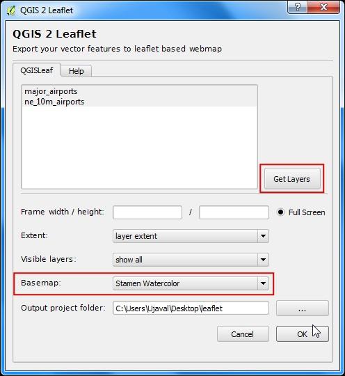
21 Georeferencer Plugin > Georeferencing and resampling of rasters > C++ core plugin
22 Database tools

23 DB Manager > Data transfer and schema editing > Core plugin

24 Offline Editing > Offline editing and database synchronization > C++ Core Plugin


25 Offline Editing > Local copy of data in Spatialite DB > Synchronization with master DB
26 Web mapping

27 Export to OpenLayers 3 > Generating HTML/Javascript for OL 3

28 qgis2leaf > Generating HTML/Javascript for Leaflet

29 QGIS Cloud Plugin > Publication of maps from QGIS desktop > OGC services, web map, mobile map,...

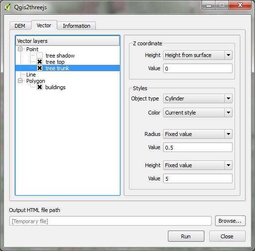
30 Qgis2threejs > Generating HTML/Javascript for threejs
31 OGC services

32 WPS Client > Client for Web Processing Services

33 MetaSearch Catalogue Client > Search CSW catalog services (Core plugin)

34 WFS 2.0 Client > WFS 2 client (Built-in WFS-Provider supports WFS 1.0)
35 Custom solutions

36 MOLUSCE > Analyse, model and simulate land use changes

37 InaSAFE > Natural hazard impact scenarios for response planning

38 TIGER-NET Water Observation and Information System (WOIS) > Satellite image processing for water resource managament in Africa (ESA)
39 Plugin development

40 Plugin Builder > Plugin template generator
 > Plugins Settings Show also experimental")
41 Plugin Reloader > Reloding Plugins after code changes (Exp.) > Plugins Settings Show also experimental plugins
 > Bonus hint: geoapis.")
42 Remote Debug > Remote Debugging of QGIS plugins (Exp.) > Bonus hint: geoapis.sourcepole.com
43 Tips > News sources: > Blogs: planet.qgis.org > Twitter #qgis > Check plugins.qgis.org > Recently updated? > Tickets?

44 FOSS4G 2015 Thank you!
Building an OpenLayers 3 map viewer with React
 FOSS4G 2015 Building an OpenLayers 3 map viewer with React @PirminKalberer Sourcepole AG, Switzerland www.sourcepole.com About Sourcepole > QGIS > > > > Core dev. & Project Steering Commitee QGIS Server,
OPEN SOURCE SOLUTIONS FOR SURVEYORS
 2 nd Sabah International Surveyors Congress 11 th 12 th March 2014 OPEN SOURCE SOLUTIONS FOR SURVEYORS Presented By : Sr Alexander Chong Director, Jurukur Antarabangsa The Benefits Of Closed Proprietary
pgrouting extends the postgis/postgresql geospatial database to provide geospatial routing and other network analysis functionality.
 Workshop: 1 pgrouting extends the postgis/postgresql geospatial database to provide geospatial routing and other network analysis functionality. Attendee s previous knowledge: SQL (PostgreSQL, PostGIS)
Implementing Web GIS Solutions
 Implementing Web GIS Solutions using open source software Karsten Vennemann Seattle Talk Overview Talk Overview Why and What What is Open Source (GIS)? Why use it? Application Components Overview of Web
Providing Interoperability Using the Open GeoServices REST Specification
 2013 Esri International User Conference July 8 12, 2013 San Diego, California Technical Workshop Providing Interoperability Using the Open GeoServices REST Specification Satish Sankaran Kevin Sigwart What
Web Map Servers. Mark de Blois. Septembre 2016
 Web Map Servers Mark de Blois Septembre 2016 Learning Objectives After this lecture you will be able to understand web map servers as used in Web-GIS applications Introduction A Web Map Server is a computer
Open Source Software: What and Why?
 ESRI and Open Source A Love Story Presented by Bates Rambow Open Source Software: What and Why? What Software that has its source code published for anyone to inspect the source code. Generally released
Open Source Software Solutions
 Open Source Software Solutions Ned Horning horning@amnh.org http://biodiversityinformatics.amnh.org 1 Overview Introduction to open source software Geospatial software options Open Source Geospatial Foundation
Georeferencing in QGIS
 Georeferencing in QGIS Introduction Georeferencing is one of the most useful tools for historians. Historic cartographic data can be digitized (scanned, downloaded) and assigned coordinate data on a modern
Searching and Downloading OpenStreetMap Data
 Searching and Downloading OpenStreetMap Data QGIS Tutorials and Tips Author Ujaval Gandhi http://www.spatialthoughts.com This work is licensed under a Creative Commons Attribution 4.0 International License.
CHAPTER 5 DIGITAL ELEVATION MODEL AND 3D VISUALIZATION
 CHAPTER 5 DIGITAL ELEVATION MODEL AND 3D VISUALIZATION A digital elevation model (DEM) is a digital model or 3D representation of a terrain's surface. A DEM can be represented as a raster (a grid of squares,
Orchard Link Mapping Workshop (QGIS Training) Contact
 Contact") Orchard Link Mapping Workshop (QGIS Training) Contact email: info@neetmaps.co.uk for technical support, bespoke mapping or further information or visit www.neetmaps.co.uk 1 2 1: Introduction to QGIS What
Orchard Link Mapping Workshop (QGIS Training) Contact email: info@neetmaps.co.uk for technical support, bespoke mapping or further information or visit www.neetmaps.co.uk 1 2 1: Introduction to QGIS What
T-rex, a vector tile server for your own data
 FOSS4G 2017 T-rex, a vector tile server for your own data @PirminKalberer Sourcepole, Zurich, Switzerland www.sourcepole.com Vector Tiles Demo > Vector tile demo > https://www.mapbox.com/maps/ Demo > Vector
Leveraging OGC Services in ArcGIS Server. Satish Sankaran, Esri Yingqi Tang, Esri
 Leveraging OGC Services in ArcGIS Server Satish Sankaran, Esri Yingqi Tang, Esri GIS Creating and Managing Geo Information Products - Proprietary - Open Specifications - Standards Dissemination of Geo
Open source technologies and INSPIRE network services in Slovak environmental agency
 Open source technologies and INSPIRE network services in Slovak environmental agency Peter Mozolík, Martin Koška, Marek Žiačik, Martin Tuchyňa Slovak Environmental Agency (SEA) SEA role within slovak SDI
Serving Imagery with ArcGIS Server 10.1
 Serving Imagery with ArcGIS Server 10.1 Presented by: André Piasta apiasta@esri.ca Esri Canada Users Conference Calgary, AB 28 May 2013 Today s Agenda ArcGIS server and image services Publishing of imagery
The Butterfly Effect. A proposal for distribution and management for butterfly data programs. Dave Waetjen SESYNC Butterfly Workshop May 10, 2012
 The Butterfly Effect A proposal for distribution and management for butterfly data programs Dave Waetjen SESYNC Butterfly Workshop May 10, 2012 http://butterfly.ucdavis.edu Citizen Science based Observation
GeoServer, The Open Source Solution for the interoperable management of geospatial data
 GeoServer, The Open Source Solution for the interoperable management of geospatial data Ing. Andrea Aime, GeoSolutions Ing. Simone Giannecchini, GeoSolutions Outline Who is GeoSolutions? Quick intro to
gvsig: towards 4D GIS
 gvsig: towards 4D GIS Salvador Bayarri IVER Salvador.Bayarri@iver.es www.gvsig.gva.es Contents gvsig's background & updates 3D visualization in gvsig Time and Animation in gvsig Implementation plan Demo
Who are we? Randal Hale. Nathan Saylor. GIS Coordinator for Hardin Co. Owner of North River Geographic Systems. Consultant. Owner of Saylor Mapping
 Who are we? Nathan Saylor Randal Hale GIS Coordinator for Hardin Co. Owner of North River Geographic Systems Owner of Saylor Mapping Consultant Been doing GIS since 2005 Been in the GIS Industry 20 something
3D webservices - where do we stand? Emmanuel Belo
 3D webservices - where do we stand? Emmanuel Belo +41 21 619 10 25 emmanuel.belo@camptocamp.com Camptocamp Open Source Service Provider Staff 49 Switzerland, France & Austria Since 2001 Wien Lausanne Chambéry
GRASS. Geographic Resources Analysis Support System Current versions. Related software
 GRASS Geographic Resources Analysis Support System http://grass.osgeo.org Current versions 6.3 stable (old) 6.4 next stable (new) 7 development (future) Related software QGIS http://qgis.org GRASS Capabilities
QGIS Tutorials Documentation
 QGIS Tutorials Documentation Release 0.1 Nathaniel Roth November 30, 2016 Contents 1 Installation 3 1.1 Basic Installation............................................. 3 1.2 Advanced Installation..........................................
SDI Tecnological Components and Standards
 SDI Tecnological Components and Standards Salvador Bayarri sbayarri@gmail.com World Bank Consultant Contents The SDI architecture model Software components: the SDI stack Basic services Metadata SDI access
Beyond PostGIS. New developments in Open Source Spatial Databases. Karsten Vennemann. Seattle
 New developments in Open Source Spatial Databases Karsten Vennemann Seattle Talk Overview Intro Relational Databases PostGIS JASPA INGRES Geospatial MySQL Spatial Support HatBox a user space extension
Qgis2threejs plugin Documentation
 Qgis2threejs plugin Documentation Release 2.0 Minoru Akagi May 16, 2018 Contents 1 Examples 3 2 Tutorial 7 3 Exporter 13 4 Object Types 23 5 Web Viewer 33 6 Development 35 i ii Note: Now being updated
InCLUDE Data Exchange. Julia Harrell, GISP GIS Coordinator, NC DENR
 InCLUDE Data Exchange Julia Harrell, GISP GIS Coordinator, NC DENR Julia.harrell@ncdenr.gov InCLUDE Project Partners NC Department of Environment & Natural Resources: The State of NC s lead environmental
GeoNode Intro & Demo
 GeoNode Intro & Demo Cristiano Giovando - Global Facility for Disaster Reduction and Recovery, World Bank Paolo Corti - Center for Geographic Analysis, Harvard University Dynamic Mapping of Secondary Cities
Setting Up and Deploying Geospatial Data Shares Using the QGIS Server Application
 Setting Up and Deploying Geospatial Data Shares Using the QGIS Server Application Donald L. Schrupp Wildlife Ecologist Colorado Division of Wildlife (retired) Quantum GIS (QGIS) Applications QGIS is not
Introduction to QGIS: Student Workbook
 2016 Introduction to QGIS: Student Workbook Created by: MARK DE BLOIS, CEO / FOUNDER, UPANDE LIMITED WITH SUPPORT FROM THE WORLD BANK AND THE UK DEPARTMENT FOR INTERNATIONAL DEVELOPMENT (DFID) Module 3:
Exploring Open Source GIS Programming. Scott Parker, Katie Urey, Jack Newlevant, Mele Sax-Barnett
 Exploring Open Source GIS Programming Scott Parker, Katie Urey, Jack Newlevant, Mele Sax-Barnett When to write a program When you expect your tool to have multiple uses and/or multiple iterations Something
Managing and Serving Elevation and Lidar Data. Cody Benkelman UC 2018
 Managing and Serving Elevation and Lidar Data Cody Benkelman UC 2018 Outline Usage Modes Data Management - Architecture - Workflow Automation for Repeatability & Scalability A few options Usage Modes of
Leveraging OGC Services in ArcGIS Server. Satish Sankaran Yingqi Tang
 Leveraging OGC Services in ArcGIS Server Satish Sankaran ssankaran@esri.com Yingqi Tang ytang@esri.com Agenda Interoperability Enablers OGC and esri OGC Web Services ArcGIS and OGC Web Services - @ version
Terrain Analysis. Using QGIS and SAGA
 Terrain Analysis Using QGIS and SAGA Tutorial ID: IGET_RS_010 This tutorial has been developed by BVIEER as part of the IGET web portal intended to provide easy access to geospatial education. This tutorial
ArcGIS Online. The Road Ahead Geoff Mortson
 ArcGIS Online The Road Ahead Geoff Mortson gmortson@esricanada.com ArcGIS Online Easily create and share maps Delivered as intelligent maps Access on virtually any device anyone, anywhere Compliments and
MapStore create, save and share maps and mashups. Dott. Ing. Mauro Bartolomeoli, GeoSolutions Ing. Simone Giannecchini, GeoSolutions
 MapStore create, save and share maps and mashups Dott. Ing. Mauro Bartolomeoli, GeoSolutions Ing. Simone Giannecchini, GeoSolutions Outline About GeoSolutions MapStore Introduction Demo Standards Architecture
WebEasy GIS is a cloud computing application for the web consultation of maps and geographic data.
 WebEasy GIS Geographic Information System WebEasy GIS is a cloud computing application for the web consultation of maps and geographic data. WebEasy GIS has a practical and intuitive interface, it works
GeoNode Integration with SDIs and Community Mapping
 GeoNode Integration with SDIs and Community Mapping Salvador Bayarri sbayarri@gmail.com World Bank Consultant Contents Accessing other SDI services Catalog harvesting through Geonetwork Cascading external
Leveraging OGC Standards on ArcGIS Server
 Leveraging OGC Standards on ArcGIS Server Satish Sankaran Interoperability and Standards Team James Michel III ESRI Intel Team ArcGIS Server Complete Interoperable Server-Based GIS Desktop Explorer Web
Interoperability and Standards Supports in ArcGIS
 Esri International User Conference San Diego, California Technical Workshops July 26, 2012 Interoperability and Standards Supports in ArcGIS Satish Sankaran, Esri Yingqi Tang, Esri Agenda Esri s participation
Modernizing California State Highway Right of Way Records with GIS. Caltrans District 4 Oakland, CA
 Modernizing California State Highway Right of Way Records with GIS Caltrans District 4 Oakland, CA About Us Kirsten Lawrence (GISP), Senior Geospatial Analyst on staff augmentation contract with Caltrans
Managing Imagery and Raster Data using Mosaic Datasets
 Esri European User Conference October 15-17, 2012 Oslo, Norway Hosted by Esri Official Distributor Managing Imagery and Raster Data using Mosaic Datasets Peter Becker ArcGIS is a Comprehensive Imagery
Norwegian Polar Institute, February 2018 Project website: quantarctica.npolar.no
 Get started with Quantarctica 3 Norwegian Polar Institute, February 2018 Project website: quantarctica.npolar.no Quantarctica is the result of an initiative by the Norwegian Polar Institute (NPI) to develop
Image Services for Elevation Data
 Image Services for Elevation Data Peter Becker Need for Elevation Using Image Services for Elevation Data sources Creating Elevation Service Requirement: GIS and Imagery, Integrated and Accessible Field
Introduction to basic GIS. International Federation of Red Cross and Red Crescent Societies Information Management Team. September 2017 Version 1.
 Introduction to basic GIS International Federation of Red Cross and Red Crescent Societies Information Management Team September 2017 Version 1.0 Introduction This is a basic GIS guidance document created
SDI SOLUTIONS FOR INSPIRE: TECHNOLOGIES SUPPORTING A FRAMEWORK OF COOPERATION
 SDI SOLUTIONS FOR INSPIRE: TECHNOLOGIES SUPPORTING A FRAMEWORK OF COOPERATION Roberto Lucchi 1, Marten Hogeweg 1, Guenther Pichler 2 1 Esri, Redlands, CA, USA 2 Esri Kranzberg, Germany 1 Vision INSPIRE
Raster Analysis and Image Processing in ArcGIS Enterprise
 Raster Analysis and Image Processing in ArcGIS Enterprise Vinay Viswambharan, Jie Zhang Overview Patterns of use - Introduction to image processing and analysis in ArcGIS - Client/Server side processing
Image Management and Dissemination. Peter Becker
 Image Management and Dissemination Peter Becker OUTLINE Requirements Intro to Mosaic Datasets Workflows & Demo Dynamic Mosaicking, On-the-fly processing Properties Differentiator Raster Catalog, ISDef,
Using R for Spatial Analysis. Tina A.
 Using R for Spatial Analysis Tina A. Cormier tina@telluslabs.com @TinaACormier Outline What is R & why should you consider using it for geo? What can you do with R? Common challenges Code examples with
InCLUDE Data Exchange. Julia Harrell, GISP GIS Coordinator, NC DENR
 InCLUDE Data Exchange Julia Harrell, GISP GIS Coordinator, NC DENR Julia.harrell@ncdenr.gov InCLUDE Project Partners NC Department of Environment & Natural Resources: The State of NC s lead environmental
SMARTERDECISIONS. Geospatial Portal 2013 Open Interoperable GIS/Imagery Services with ERDAS Apollo 2013 and ERDAS Imagine 2013
 Geospatial Portal 2013 Open Interoperable GIS/Imagery Services with ERDAS Apollo 2013 and ERDAS Imagine 2013 Carahsoft Intergraph Government Solutions SMARTERDECISIONS Geospatial Portal 2013 Geospatial
An Overview of FMW MapViewer
 An Overview of FMW MapViewer Agenda What is MapViewer Select Features Getting Started Additional Resources 2 Copyright 2013, Oracle and/or its affiliates. All rights reserved. Oracle
ArcGIS for Server Michele Lundeen
 ArcGIS for Server 10.1 Michele Lundeen Summary Vision Installation and Configuration Architecture Publishing Functional Enhancements Cloud Migration and Best Practices Powerful GIS capabilities Delivered
[ ]..,ru. GeoServer Beginner's Guide. open source^ software server. Share and edit geospatial data with this open source.
![[ ]..,ru. GeoServer Beginner's Guide. open source^ software server. Share and edit geospatial data with this open source.](/thumbs/80/80955530.jpg "[ ]..,ru. GeoServer Beginner's Guide. open source^ software server. Share and edit geospatial data with this open source.") GeoServer Beginner's Guide Share and edit geospatial data with this open source software server Stefano lacovella Brian Youngblood [ ]..,ru open source^ PUBLISHING community experience distilled BIRMINGHAMMUMBAI
GeoServer Beginner's Guide Share and edit geospatial data with this open source software server Stefano lacovella Brian Youngblood [ ]..,ru open source^ PUBLISHING community experience distilled BIRMINGHAMMUMBAI
May 22, 2013 Ronald Reagan Building and International Trade Center Washington, DC USA
 May 22, 2013 Ronald Reagan Building and International Trade Center Washington, DC USA 1 Building Applications with Oracle MapViewer LJ Qian (lj.qian@oracle.com) Director, Software Development The following
MapStore create, save and share maps and mashups. Ing. Alejandro Díaz, GeoSolutions
 MapStore create, save and share maps and mashups Ing. Alejandro Díaz, GeoSolutions Outline About GeoSolutions MapStore Introduction Demo Standards Architecture Tools Implementations GeoSolutions Founded
Preparation of contouring, hill shade and slope map of erode district by using QGIS
 ISSN:2348-2079 Volume-6 Issue-2 International Journal of Intellectual Advancements and Research in Engineering Computations Preparation of contouring, hill shade and slope map of erode district by using
Introduction to ArcGIS Server 10.1
 Introduction to ArcGIS Server 10.1 E-Learning for the GIS Professional Any Time, Any Place! geospatialtraining.com Module Outline What is ArcGIS Server? GIS Resources and Services ArcGIS Server Components
HEC-RAS 5.0 Training New Zealand Workshop Guide
 HEC-RAS 5.0 Training New Zealand Workshop Guide Prepared by: Krey Price Surface Water Solutions 57 Bromfield Drive Kelmscott WA 6111 Australia Tel. +61 400 367 542 e-mail: info@surfacewater.biz website:
Introduction to QGIS: Instructor s Notes
 2016 Introduction to QGIS: Instructor s Notes Created by: MARK DE BLOIS, CEO / FOUNDER, UPANDE LIMITED WITH SUPPORT FROM THE WORLD BANK AND THE UK DEPARTMENT FOR INTERNATIONAL DEVELOPMENT (DFID) Module
Oracle Spatial Users Conference
 April 2006 April 27, 2006 Tampa Convention Center Tampa, Florida, USA April 2006 Michael Smith Physical Scientist Remote Sensing/GIS Center of Expertise Army Corps of Engineers Engineer Research & Development
COMPONENTS. The web interface includes user administration tools, which allow companies to efficiently distribute data to internal or external users.
 COMPONENTS LASERDATA LIS is a software suite for LiDAR data (TLS / MLS / ALS) management and analysis. The software is built on top of a GIS and supports both point and raster data. The following software
Developing Qt Apps with the Runtime SDK
 Developing Qt Apps with the Runtime SDK Thomas Dunn and Michael Tims Esri UC 2014 Technical Workshop Agenda Getting Started Creating the Map Geocoding and Routing Geoprocessing Message Processing Work
ArcGIS Online: Managing Data. Jeremy Bartley Sentha Sivabalan
 ArcGIS Online: Managing Data Jeremy Bartley (jbartley@esri.com) Sentha Sivabalan (ssivabalan@esri.com) Agenda Creating and managing content like Apps, Maps, Scenes and Layers in ArcGIS Today s Topics:
Working with Feature Layers. Russell Brennan Gary MacDougall
 Working with Feature Layers Russell Brennan Gary MacDougall Working with Feature Layers Session will focus on feature access and editing Highlight new features added over the last few releases Agenda Introduction
Workflows for Managing and Serving Elevation (and Lidar) Data. Cody Benkelman
 Data. Cody Benkelman") Workflows for Managing and Serving Elevation (and Lidar) Data Cody Benkelman Outline Usage Modes Data Management - Architecture - Workflow Automation for Repeatability & Scalability A few options re: Cloud,
Workflows for Managing and Serving Elevation (and Lidar) Data Cody Benkelman Outline Usage Modes Data Management - Architecture - Workflow Automation for Repeatability & Scalability A few options re: Cloud,
County of Los Angeles. Chief Information Office Preferred Technologies for Geographic Information Systems (GIS) Version 2 May 2015
 Version 2 May 2015") County of Los Angeles Chief Information Office Preferred Technologies for Geographic Information Systems (GIS) Version 2 May 2015 CIO Preferred Technologies for GIS This document lists the preferred Geographic
County of Los Angeles Chief Information Office Preferred Technologies for Geographic Information Systems (GIS) Version 2 May 2015 CIO Preferred Technologies for GIS This document lists the preferred Geographic
Distributed Image Analysis Using the ArcGIS API for Python
 Distributed Image Analysis Using the ArcGIS API for Python Jie Zhang, Elizabeth Graham The ArcGIS Platform Is a Comprehensive Imagery Platform System of Engagement System of Insight Professional Imagery
GeoNetwork: metadata and cataloging French (GeoSource) and Swiss (geocat.ch) experiences
 and Swiss (geocat.ch) experiences") GeoNetwork: metadata and cataloging French (GeoSource) and Swiss (geocat.ch) experiences camptocamp SA / 12. mars 2009 / www.camptocamp.com / info@camptocamp.com Camptocamp, a Franco-Swiss company A Franco-Swiss
GeoNetwork: metadata and cataloging French (GeoSource) and Swiss (geocat.ch) experiences camptocamp SA / 12. mars 2009 / www.camptocamp.com / info@camptocamp.com Camptocamp, a Franco-Swiss company A Franco-Swiss
Geog183: Cartographic Design and Geovisualization Spring Quarter 2018 Lecture 10: Production, Reproduction and Dissemination
 Geog183: Cartographic Design and Geovisualization Spring Quarter 2018 Lecture 10: Production, Reproduction and Dissemination Historical development Ancient maps: many media and materials Papyrus used in
What s New in ArcGIS Server 10
 What s New in ArcGIS Server 10 Derek Law ArcGIS Server Product Management What s s new in ArcGIS Server 10? Agenda Highlights: Enhanced Web mapping More powerful server-based analysis Geo-collaboration
International Organization for Standardization Technical Committee 211 (ISO/TC211)
") Esri Support for Geospatial Standards: Open Geospatial Consortium (OGC) International Organization for Standardization Technical Committee 211 (ISO/TC211) An Esri White Paper April 2015 Copyright 2015
Esri Support for Geospatial Standards: Open Geospatial Consortium (OGC) International Organization for Standardization Technical Committee 211 (ISO/TC211) An Esri White Paper April 2015 Copyright 2015
Introduction to using QGIS for Archaeology and History Workshop by the Empirical Reasoning Center
 Introduction to using QGIS for Archaeology and History Workshop by the Empirical Reasoning Center In this workshop, we will cover the basics of working with spatial data, as well as its main uses for archaeology.
UWWTD SIIF national toolbox How to manage the UWWTD SIIF toolbox
 Specific contract n 07.0201/2014/SFRA/698614/ENV.C.2 implementing Framework Service Contract ENV.D.2/FRA/2012/0013: Expanding the Urban Wastewater Structured Information and Implementation Framework (SIIF)
Managing Imagery And Raster Data Using Mosaic Dataset. Peter Becker & Cody Benkelman
 Managing Imagery And Raster Data Using Mosaic Dataset Peter Becker & Cody Benkelman ArcGIS is a Comprehensive Imagery Platform Imagery is integral to the ArcGIS Platform System of Engagement System of
Vegetation height maps derived from digital elevation models the next innovation in the production of orienteering maps?
 Vegetation height maps derived from digital elevation models the next innovation in the production of orienteering maps? Development of Orienteering Maps. 1. Revolution 20 years ago: Digital Cartography
Processing and dissemination of satellite remote sensing data in an heterogeneous environment.
 Victoria, BC, Canada on 25 September 2007 FOSS4G2007 Conference 1 Processing and dissemination of satellite remote sensing data in an heterogeneous environment. Armin Burger, Paul Hasenohr armin.burger@jrc.it,
QGIS for Geoscientists
 QGIS for Geoscientists Robin Armit, Tom Carmichael, Lachlan Grose Monash Structural Geophysics group 22 nd 26th February 2016 GIS A geographic information system (GIS) is a system designed to capture,
MIKE Release 2019 News and features. October 2018
 MIKE Release 2019 News and features October 2018 What s new in MIKE 2019 release? Marine updates Urban updates Inland updates DHI MIKE Release 2019 Urban Water Morten Kjølby What s new MIKE URBAN 2019
CHAPTER 2 GEOREFERENCING AND SHAPEFILE CREATION
 CHAPTER 2 GEOREFERENCING AND SHAPEFILE CREATION Georeferencing is the process of assigning real-world coordinates to each pixel of the raster. These coordinates are obtained by doing field surveys - collecting
ArcGIS for Server Imagery Update. Cody A. Benkelman Technical Product Manager, Imagery
 ArcGIS for Server Imagery Update Cody A. Benkelman Technical Product Manager, Imagery Outline Mosaic dataset Management and dissemination of imagery - Dynamic image services, Tiled Cache Visualization
ITS488 Geographic Informa5on System
 ITS488 Geographic Informa5on System 11-1 Open source GIS 2014 10 29 Teerayut Horanont, PhD Sirindhorn Interna5onal Ins5tute of Technology (SIIT) Thammasat University E: teerayut@siit.tu.ac.th 10/29/14
Deploying ios Apps. Al Pascual
 Deploying ios Apps Al Pascual Overview Device Platform Strategy Built from a common GIS Runtime Configurable Apps ArcGIS for ios, Android, Windows Phone Collector for ArcGIS Operations Dashboard Additional
Carmenta Server Product Description
 White paper Carmenta Server Product Description Carmenta AB, Tel +46-31-775 57 00, www.carmenta.com P315 121RD, 2010 Carmenta reserves the right to change the specifications at any time and without notice.
Raster Analytics in Image Server: An Introduction. Mike Muller
 Raster Analytics in Image Server: An Introduction Mike Muller Introduction and Context The ArcGIS Platform and ArcGIS Image Server enable access to imagery and analysis through a wide range of integrated
QGIS GML application schema toolbox guided tour use case on French Groundwater Information Network (GIN)
") QGIS GML application schema toolbox guided tour use case on French Groundwater Information Network (GIN) S.Grellet BRGM / H.Mercier Oslandia French GIN linked data use case > Objectives To provide stable
QGIS GML application schema toolbox guided tour use case on French Groundwater Information Network (GIN) S.Grellet BRGM / H.Mercier Oslandia French GIN linked data use case > Objectives To provide stable
A ONE-STOP SERVICE HUB INTEGRATING ESSENTIAL WEATHER AND GEOPHYSICAL INFORMATION ON A GIS PLATFORM. Hong Kong Observatory
 A ONE-STOP SERVICE HUB INTEGRATING ESSENTIAL WEATHER AND GEOPHYSICAL INFORMATION ON A GIS PLATFORM Hong Kong Observatory Mission HONG KONG OBSERVATORY To provide people-oriented quality services in meteorology
Feature Extraction from Imagery & Lidar. Kurt Schwoppe, Esri Mark Romero, Esri Gregory Bacon, Fairfax County
 Feature Extraction from & Lidar Kurt Schwoppe, Esri Mark Romero, Esri Gregory Bacon, Fairfax County Today s Speakers Image Processing Experts and Good Colleagues Kurt Schwoppe Industry Lead Esri Mark Romero
Introducing Quantum GIS. Tim Sutton QGIS Release Manager and Developer
 Introducing Quantum GIS Tim Sutton QGIS Release Manager and Developer tim@linfiniti.com http://linfiniti.com What is QGIS? A Free, Open Source Desktop GIS application A set of developer libraries for building
PFMS OPERATION MANUAL FOR PROVINCIAL FOREST MONITORING DATABASE (FOR DISTRICT FPDS)
") PFMS OPERATION MANUAL FOR PROVINCIAL FOREST MONITORING DATABASE (FOR DISTRICT FPDS) Preface This provincial forest monitoring database operation manual for district level provides step by step guidance
PFMS OPERATION MANUAL FOR PROVINCIAL FOREST MONITORING DATABASE (FOR DISTRICT FPDS) Preface This provincial forest monitoring database operation manual for district level provides step by step guidance
Getting Started with ArcGIS for Server. Charmel Menzel and Ken Gorton
 Getting Started with ArcGIS for Server Charmel Menzel and Ken Gorton Agenda What is ArcGIS for Server? Types of Web services Publishing resources onto the Web Clients to ArcGIS for Server Editions and
PhotoScan. Fully automated professional photogrammetric kit
 PhotoScan Fully automated professional photogrammetric kit Agisoft PhotoScan is a stand-alone photogrammetric software solution for automatic generation of dense point clouds, textured polygonal models,
OSGeo Web Mapping Typification: GeoMajas, Mapbender, MapFish and OpenLayers. Christoph Baudson Arnulf Christl FOSS4G 2010 Barcelona
 OSGeo Web Mapping Typification: GeoMajas, Mapbender, MapFish and OpenLayers Christoph Baudson Arnulf Christl FOSS4G 2010 Barcelona Disclaimer All information contained in this presentation has been compiled
ArcGIS Runtime SDK for WPF
 Esri Developer Summit in Europe November 9 th Rotterdam ArcGIS Runtime SDK for WPF Mike Branscomb Mark Baird Agenda Introduction SDK Building the Map Query Spatial Analysis Editing and Geometry Programming
FLOOD MONITORING WITH SENTINEL-1 USING S-1 TOOLBOX - JANUARY 2015, MALAWI
 TRAINING KIT HAZA01 FLOOD MONITORING WITH SENTINEL-1 USING S-1 TOOLBOX - JANUARY 2015, MALAWI Table of Contents 1 Introduction to RUS... 2 2 Training... 2 2.1 Data used... 2 2.2 Software in RUS environment...
Paul Hardy. We Live in a Rapidly Changing World. Mobile Mapping: Collect, Manage, Produce, Share. MMT Krakow, Many Forces Are Converging
 Mobile Mapping: Collect, Manage, Produce, Share MMT Krakow, 2011 Paul Hardy We Live in a Rapidly Changing World Increasingly Driven by Population Growth & Human Action Impacting Environment Society Economy
EUCOM/AFRICOM DEFENSE USER GROUP MEETING MARCH 2010 STUTTGART WELCOME!
 EUCOM/AFRICOM DEFENSE USER GROUP MEETING 23-25 MARCH 2010 STUTTGART WELCOME! AGENDA March 23, Tuesday 0800-0900 Registration 0900-0915 Welcome and Introductions 0915-1000 Getting Started with ArcGIS Server
Developing an Advanced Document Based Map Server *
 Proceedings of the 8 th International Conference on Applied Informatics Eger, Hungary, January 27 30, 2010. Vol. 1. pp. 337 344. Developing an Advanced Document Based Map Server * Roberto Giachetta a,
By Robert Slivinsky 1
 By Robert Slivinsky 1 Tell HC Mobile Application SQL Server 2008 GeoServer GeoExt- Open Layers 2 3 Desktop Splash Page 2 sec GPS/Location Approval 4 Homepage Meat - Form Categories from EOCcalls 5 Description
Leveraging OGC Services in ArcGIS Server
 Esri International User Conference San Diego, CA Technical Workshops Jul.14 th 2011 Leveraging OGC Services in ArcGIS Server Satish Sankaran Yingqi Tang Agenda Interoperability