Leveraging OGC Services in ArcGIS Server
|
|
|
- Alexandrina Riley
- 5 years ago
- Views:
Transcription


1 Esri International User Conference San Diego, CA Technical Workshops Jul.14 th 2011 Leveraging OGC Services in ArcGIS Server Satish Sankaran Yingqi Tang
2 Agenda Interoperability Enablers OGC and esri OGC Web Services ArcGIS and OGC Web Services version 10.0 version 10.1


3 ArcGIS 10 A Complete System Mobile Web Discover Create Manage Visualize Analyze Collaborate Cloud Enterprise Local Desktop A
4 ArcGIS Server is Open & Interoperable Using Standards to Integrate with Any System Web REST, SOAP XML,KML,... OGC GML, WFS, WMS, WCS... Enterprise Integration Google SOAP, XML, EJB, SQL Application Content AutoCAD CAD, Image, PDF Virtual Earth Any Client/Any Application SAP ENVI GeoMedia Imagine Ionic Standards ArcGIS Server MapInfo
5 Interoperability Enablers ETL Interoperability - DGN, DWG, MIF Interoperability through Open Standards - OGC Simple Features - SF-SQL, SF-OLE/COM - GML, OGC KML - OGC Web Services - WMS, WFS, WCS, CS-W, OGC KML, WPS, WMTS Interoperability through Open Specifications - Shapefiles, File Geodatabase API, Geoservices Specification - GeoRSS, KML


6 Where does OGC fit in the standards world? ISO & Other National Domains: oobject/abstract omodels ocontent ovocabulary OASIS/IETF / W3C Infrastructure: o WSDL o UDDI o SOAP o XML
7 ESRI s s OGC Participation Serving many roles within OGC Principal member Actively participates: Technical Committee Planning Committee Board of Directors All three OGC programs Interoperability program Standards program Community Outreach and Adoption program Architecture Board Chair Standards and Domain Working Groups
8 OGC Web Services I-87 I-295 I-95 Web Map Service Geospatial picture publishing/viewing service Web Feature Service Geospatial feature publishing/streaming service I-87 I-295 I-95 Web Coverage Service Imagery and gridded data publishing/processing service Keyhole Markup Language Service Geospatial feature publishing/streaming service
9 ArcGIS Server - Supporting OGC Services Building open and interoperable Systems ArcGIS Desktop Google Earth ArcExplorer ArcGIS Web ADF Imagine ENVI Gaia gvsig AutoCAD OpenLayers OGC Services GeoMedia Ionic Standards QGIS udig ArcGIS Server MapInfo
10 Service Oriented Architecture ArcGIS Supports Interoperability for: Service Service Requester Requester Client - Spatial Data Infrastructures Find Find Bind Bind Interact Interact Service Description Service Service Broker Broker - Enterprise Architectures Publish Service Service Service Provider Provider Service Description - Neogeography, Mashup and WEB 2.0 environments
11 OGC Service Encodings Key Value Pair (KVP) - Using HTTP GET / POST SOAP RESTful

12 RESTful Encoding / Style Richardson Maturity Model
13 WMS WMS on MapService KML 1.0.0, 1.1.0, 1.1.1, GetCapabilities GetMap GetFeatureInfo ArcGIS Desktop client WebADF client KML on MapService KML 2.1 Add WMS on ImageService Styled Layer Descriptors (SLD) publish multiple styles at server side send external styles through SLD Filter Encoding (FE) in SLD Security (inherits ArcGIS Server Security Framework) Bug fixes KML on ImageService and GeoDataService KML through ArcGIS REST API Bug fixes WCS WCS on MapService WCS on ImageService WCS on GeoDataService 1.0.0, 1.1.0, GetCapabilities DescribeCoverage GetCoverage Add WMS on optimized map service Support SLD_BODY Support GetStyle Support GetLegendGraphic Support WMS-T (TIME) Bug fixes KML 2.2 (to OGC namespace) Support TIME in KML Bug fixes Bug fixes Updated Make WCS layer GP tool Add WCS on Optimized Map Service Ass TIME support Bug fixes WMTS Add WMTS on cached map service Bug fixes Bug fixes WFS Make WCS layer GP tool ArcGIS Desktop client WFST on MapService WFST on GeoDataService OGC Services Support GetCapabilities DescribeFeatureType GetFeature GetFeatureWithLock Transaction Data Interoperability Extension WFS to FeatureClass GP tool Add WFST (9.3 SP1) Add WFS on Optimized MapService Add WFST on non-versioned geodatabase Bug fixes Performance enhancement Bug fixes Add WPS on Geoprocessing Service WPS
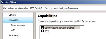
14 OGC Services in ArcGIS Server - Architecture Implemented as capabilities of ArcGIS Server services - Map Service - WMS, WCS, WFS, KML, WMTS (10.1) - Image Service - WMS, WCS, KML - GeoData Service - WCS, WFS, KML - Geoprocessing Service - WPS (10.1)
15 OGC Services in ArcGIS Server - Architecture Inherit from ArcGIS Server services - Rich features from ArcObjects - cartography, geodatabase, caching, geoprocessing etc. - Good authoring and publishing work flow - Scalability and Durability in distributed environment - Performance - Security mechanism
16
17
18
19
20
21
22 WMS in ArcGIS Server Serving map, legend, styles and limited feature data - Supported versions , 1.1.0, 1.1.1, Supported operations - GetCapabilities - GetMap - GetFeatureInfo - GetStyle - GetLegendGraphic
23 WMS in ArcGIS Server Cont. Highlights - Styled Layer Descriptor (SLD) - Support both OGC Symbology and Filter encoding spec - Support SLD and SLD_BODY parameter - GetStyles and GetLegendGraphic - TIME - XSLT template for GetFeatureInfo - Security (http basic, digest, token based)


24 SLD work flow Step 4: Push SLD back to server using SLD_BODY Step 1: Data and map document ArcGIS Servers OGC WMS Internet WMS clients Step 3: 3 GetStyles return SLD definition for Named-style Step 2: publish additional Named-Style SLD XML


25 Customize GetFeatureInfo response using XSLT Data and Map document XSLT template to embed videos XSLT template to embed pictures Default response ArcGIS Servers OGC WMS Internet WMS client Default XSLT template for GetFeatureInfo response XSLT template to embed JS code

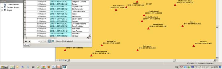
26 WMS TIME support
27

28
29 KML in ArcGIS Server Serving dynamic/cached maps and imagery, 2D/3D vectors - Supported versions - 2.2, no extensions - Supported operations - \GenerateKML (Mapping: 2D/3D vectors and/or GroundOverlays) - \Query (Mapping: 2D/3D vectors) - \Execute (GP only) - \ReverseGeocode (Geocode only) - Supported resources - \mapimage.kmz (Mapping and Imaging: Region based GroundOverlays) - \MapServer?f=kmz (footprint) - \ImageServer?f=kmz (footprint)
30 KML in ArcGIS Server Cont. Highlights - Regions for cached services - 2D and 3D vectors with extrusion expressions - Simple renderers (lines and polygons) with transparency - Labeling for point placemarks - HTML popups with xsl styling - Time - Legends
31 WMS and KML Demo Leverage ArcGIS Server WMS in QGIS Leverage ArcGIS Server WMS in ArcGIS.com Time Slider in ArcMap with Time enabled WMS Leverage KML in Google Earth
32 WFS in ArcGIS Server Data service, serving out geographic feature data Version implemented 1.0.0, WFS interfaces implemented GetCapabilities DescribeFeature GetFeature Transaction
33 WFS in ArcGIS Server Highlights - Simple Features GML - Transactions on versioned data - Transactions on non-versioned data - Field Aliases and Visibility Constraints - DefaultMaxFeatures property - Security (http basic, digest and token based)
34 WFS/WFST work flow WFS viewer Default version Non-versioned Editing WFS service ArcMap Reconcile Internet WFS version Versioned Editing WFST service Edits ArcSDE Geodatabase ArcGIS Server WFST editor
35 ArcGIS as a WFS Client Data Interoperability Extension Internet WFS services ArcGIS Desktop Data Interop Connection ArcMap WFS to Feature Class GP tool Internet Internet WFS services Geoprocessing tool Geodatabase Feature Class
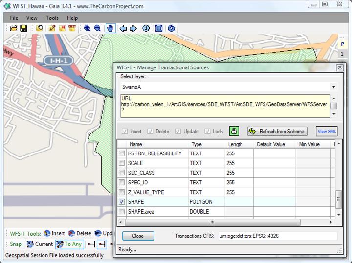
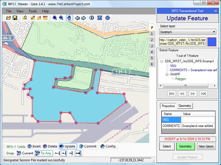
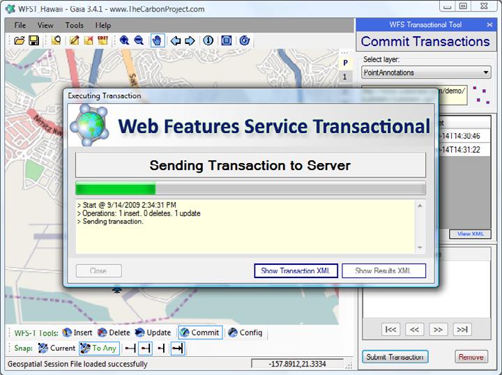
36 WFS Demo Web editing through WFST in OpenLayers Wed editing through Gaia (screenshots)
37
38
39
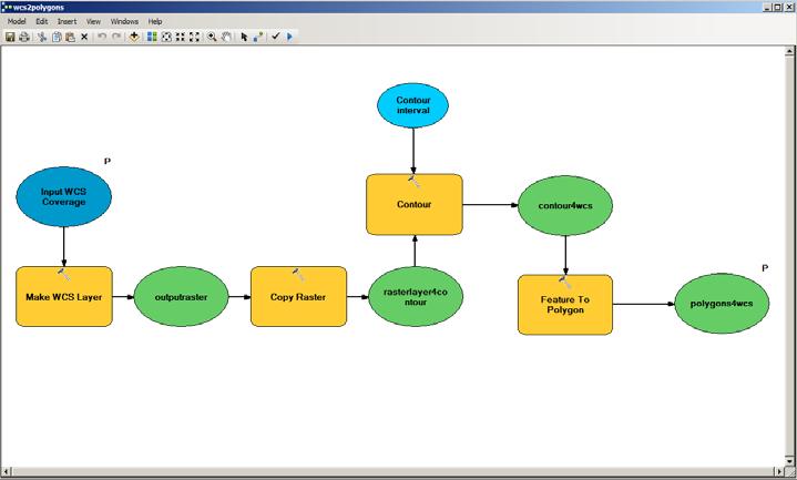
40 WCS in ArcGIS Server Data service, serving out geographic coverage data Version implemented 1.0.0, 1.1.0, and WCS interfaces implemented GetCapabilities DescribeCoverage GetCoverage (coverage data) Highlights Supported formats: GeoTIFF, NITF, HDF, JPEG, JPEG2000, PNG; TIME IMAGE (ESRI specific parameter to request an individual raster in a raster catalog) Security (http basic, digest and token based)
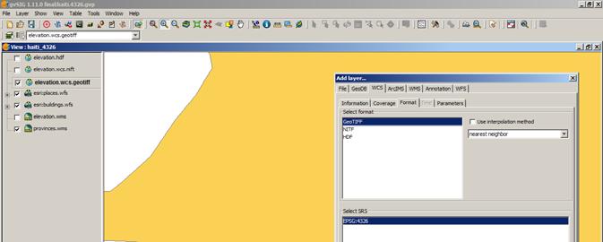
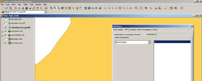
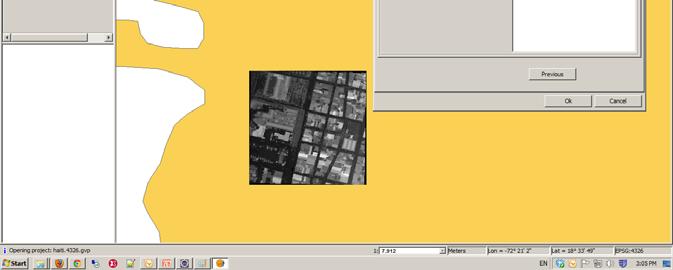
41 WCS Demo Leverage ArcGIS Server WCS in gvsig (screenshot)
42
43
44
45
46 WMTS in ArcGIS Server (10.1 Only) Serving pre-cached map tiles Version implemented WMTS interfaces implemented GetCapabilities GetTile
47 WMTS in ArcGIS Server (10.1 Only) Highlights Cache creation and management tools Performance and scalability
48 WMTS Clients OpenLayers Gaia ArcGIS JavaScript API Other generic tile service client - udig - OpenScales - DeepEarth
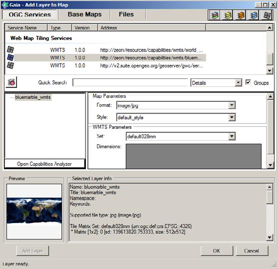
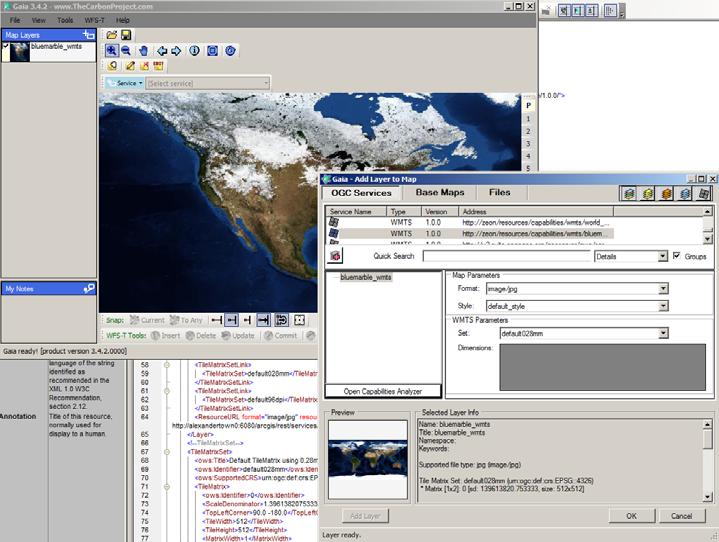
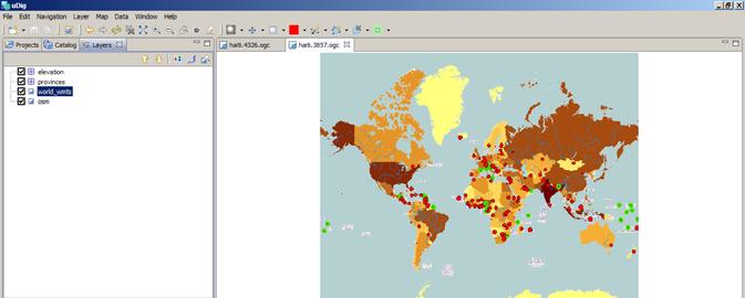
49 WMTS Demo Leverage ArcGIS Server WMTS in OpenLayers Leverage ArcGIS Server WMTS in ArcGIS Script API Leverage ArcGIS Server WMTS in Gaia (screenshot) Leverage ArcGIS Server WMTS in udig (screenshot)
50
51
52
53
54 WPS in ArcGIS Server (10.1 Only) Geospatial processes over the web Version implemented WPS interfaces implemented GetCapabilities DescribeProcess Execute Highlights Out-of of-the-box GP tools and scripts Python scripting environment and Model Builder Synchronous and Asynchronous execute mode Input and output features as GML
55 WPS Clients 52North - OpenLayers client (JavaScript) - udig (Java) OpenLayers QGIS PyWPS OpenLayers client (JavaScript) ZOO API (server-side JavaScript)
56 WPS Demo WPS in OpenLayers
Leveraging OGC Services in ArcGIS Server. Satish Sankaran Yingqi Tang
 Leveraging OGC Services in ArcGIS Server Satish Sankaran ssankaran@esri.com Yingqi Tang ytang@esri.com Agenda Interoperability Enablers OGC and esri OGC Web Services ArcGIS and OGC Web Services - @ version
Leveraging OGC Standards on ArcGIS Server
 Leveraging OGC Standards on ArcGIS Server Satish Sankaran Interoperability and Standards Team James Michel III ESRI Intel Team ArcGIS Server Complete Interoperable Server-Based GIS Desktop Explorer Web
Leveraging OGC Services in ArcGIS Server. Satish Sankaran, Esri Yingqi Tang, Esri
 Leveraging OGC Services in ArcGIS Server Satish Sankaran, Esri Yingqi Tang, Esri GIS Creating and Managing Geo Information Products - Proprietary - Open Specifications - Standards Dissemination of Geo
Providing Interoperability Using the Open GeoServices REST Specification
 2013 Esri International User Conference July 8 12, 2013 San Diego, California Technical Workshop Providing Interoperability Using the Open GeoServices REST Specification Satish Sankaran Kevin Sigwart What
Interoperability and Standards Supports in ArcGIS
 Esri International User Conference San Diego, California Technical Workshops July 26, 2012 Interoperability and Standards Supports in ArcGIS Satish Sankaran, Esri Yingqi Tang, Esri Agenda Esri s participation
SDI SOLUTIONS FOR INSPIRE: TECHNOLOGIES SUPPORTING A FRAMEWORK OF COOPERATION
 SDI SOLUTIONS FOR INSPIRE: TECHNOLOGIES SUPPORTING A FRAMEWORK OF COOPERATION Roberto Lucchi 1, Marten Hogeweg 1, Guenther Pichler 2 1 Esri, Redlands, CA, USA 2 Esri Kranzberg, Germany 1 Vision INSPIRE
Achieving Interoperability using the ArcGIS Platform. Satish Sankaran Roberto Lucchi
 Achieving Interoperability using the ArcGIS Platform Satish Sankaran Roberto Lucchi Thank you Please fill out the session survey in your mobile app Select [Achieving Interoperability using the ArcGIS Platform]
Getting Started with ArcGIS for Server. Charmel Menzel and Ken Gorton
 Getting Started with ArcGIS for Server Charmel Menzel and Ken Gorton Agenda What is ArcGIS for Server? Types of Web services Publishing resources onto the Web Clients to ArcGIS for Server Editions and
ArcGIS 9.2 Works as a Complete System
 ArcGIS 9.2 Works as a Complete System A New Way to Manage and Disseminate Geographic Knowledge Author/Serve/Use Maps Data Models Globes Metadata Use Desktop Explorer Web Map Viewer Mobile Open APIs Enterprise
What s New in ArcGIS Server 10
 What s New in ArcGIS Server 10 Derek Law ArcGIS Server Product Management What s s new in ArcGIS Server 10? Agenda Highlights: Enhanced Web mapping More powerful server-based analysis Geo-collaboration
Esri Support for Geospatial Standards
 APRIL 2017 ArcGIS Is Open and Interoperable Esri Support for Geospatial Standards Copyright 2017 Esri All rights reserved. Printed in the United States of America. The information contained in this document
SuperGIS Server 3.2 Value Edition Specification
 SuperGIS Server 3.2 Value Edition Specification 20140826 Specification 1. All of the services support SOAP (Simple Object Access Protocol). 2. Use map file created by SuperGIS Desktop as map services SuperGIS
How to become an INSPIRE node and fully exploit the investments made?
 How to become an INSPIRE node and fully exploit the investments made? Solution patterns for consumers: end users & developers (2/2) Roberto Lucchi 22 June 2010, Krakow 1 Geoportal extension Enabling discovery
Achieving Interoperability Using Open Standards
 FedGIS Conference February 24 25, 2016 Washington, DC Achieving Interoperability Using Open Standards Satish Sankaran Marten Hogeweg Agenda Understanding Interoperability What, Why and How? ArcGIS Platform
EUCOM/AFRICOM DEFENSE USER GROUP MEETING MARCH 2010 STUTTGART WELCOME!
 EUCOM/AFRICOM DEFENSE USER GROUP MEETING 23-25 MARCH 2010 STUTTGART WELCOME! AGENDA March 23, Tuesday 0800-0900 Registration 0900-0915 Welcome and Introductions 0915-1000 Getting Started with ArcGIS Server
Web Map Servers. Mark de Blois. Septembre 2016
 Web Map Servers Mark de Blois Septembre 2016 Learning Objectives After this lecture you will be able to understand web map servers as used in Web-GIS applications Introduction A Web Map Server is a computer
ArcGIS Online. The Road Ahead Geoff Mortson
 ArcGIS Online The Road Ahead Geoff Mortson gmortson@esricanada.com ArcGIS Online Easily create and share maps Delivered as intelligent maps Access on virtually any device anyone, anywhere Compliments and
Managing Image Data on the ArcGIS Platform Options and Recommended Approaches
 Managing Image Data on the ArcGIS Platform Options and Recommended Approaches Peter Becker Petroleum requirements for imagery and raster Traditional solutions and issues Overview of ArcGIS imaging capabilities
Introduction to ArcGIS Server Architecture and Services. Amr Wahba
 Introduction to ArcGIS Server 10.1 - Architecture and Services Amr Wahba awahba@esri.com Agenda Architecture Features Publishing Security Cloud Powerful GIS capabilities Delivered as Web services To help
SDI Tecnological Components and Standards
 SDI Tecnological Components and Standards Salvador Bayarri sbayarri@gmail.com World Bank Consultant Contents The SDI architecture model Software components: the SDI stack Basic services Metadata SDI access
ICIT. Brian Hiller ESRI Account Manger. What s new in ArcGIS 10
 ICIT Brian Hiller ESRI Account Manger What s new in ArcGIS 10 ArcGIS 10 Fast Easy Powerful Everywhere late June 2010 ArcGIS System for Geographic Information Desktop Server Mobile Online A System A Complete
ArcGIS Viewer for Microsoft Silverlight An Introduction
 Esri International User Conference San Diego, CA Technical Workshops July 12, 2011 ArcGIS Viewer for Microsoft Silverlight An Introduction Art Haddad, Rich Zwaap, and Derek Law Agenda Background Product
An Introduction to Data Interoperability
 Esri International User Conference San Diego, California 2012 Technical Workshops July 24/25 An Introduction to Data Interoperability Bruce Harold - Esri Dale Lutz Safe Software Background Why Data Interoperability?
Introduction to ArcGIS Server 10.1
 Introduction to ArcGIS Server 10.1 E-Learning for the GIS Professional Any Time, Any Place! geospatialtraining.com Module Outline What is ArcGIS Server? GIS Resources and Services ArcGIS Server Components
Interoperability with ArcGIS
 Interoperability with ArcGIS Satish Sankaran Marten Hogeweg Agenda Understanding Interoperability What, Why and How? ArcGIS Platform An Open Platform Supporting Interoperability Examples from the real
Desktop. ArcGIS Server. ArcGIS
 Getting Started with ArcGIS Server Nakul Bhatia and David Crosby ESRI Charlotte 1 Agenda g Overview of ArcGIS Server 9.3.1 Working with GIS Services Using g Web GIS Service Clients ArcGIS Online Map Caching
International Organization for Standardization Technical Committee 211 (ISO/TC211)
") Esri Support for Geospatial Standards: Open Geospatial Consortium (OGC) International Organization for Standardization Technical Committee 211 (ISO/TC211) An Esri White Paper April 2015 Copyright 2015
Esri Support for Geospatial Standards: Open Geospatial Consortium (OGC) International Organization for Standardization Technical Committee 211 (ISO/TC211) An Esri White Paper April 2015 Copyright 2015
Interactive Web Mapping: Overview
 Interactive Web Mapping: Overview Overview of how geospatial data is formatted requested supplied consumed by/for web technologies 2 Definitions Analysis exploring and modeling geospatial phenomena Mapping
Getting Started with the ArcGIS Server JavaScript API
 Getting Started with the ArcGIS Server JavaScript API Agenda Introduction ArcGIS Server services and mashups REST API Services Directory JavaScript API ArcGIS Server Resource Center Dojo Maps, layers,
Adopting the Appropriate GIS Web Service Technologies
 Adopting the Appropriate GIS Web Service Technologies Bo Guo, PE, PhD GIS/IT Integration Consultant Gistic Research Inc. UT & AZ Jake Payne Database Administrator & Architect State of Utah Department of
Working with the ArcGIS Viewer for Flex Application Builder
 Working with the ArcGIS Viewer for Flex Application Builder Esri Canada User Conference St. John s November 15, 2012 Presented By: Greg Yetman gyetman@esri.ca Agenda This seminar is designed to help you
Designing and Using Cached Map Services
 Esri International User Conference San Diego, California Technical Workshops July 2012 Designing and Using Cached Map Services Sterling Quinn Eric Rodenberg What we will cover Session Topics - Map cache
GEOSPATIAL ERDAS APOLLO. Your Geospatial Business System for Managing and Serving Information
 GEOSPATIAL ERDAS APOLLO Your Geospatial Business System for Managing and Serving Information ERDAS APOLLO Do you have large volumes of data, a geographicallydistributed user base and rapidly changing
ArcGIS Online: Managing Data. Jeremy Bartley Sentha Sivabalan
 ArcGIS Online: Managing Data Jeremy Bartley (jbartley@esri.com) Sentha Sivabalan (ssivabalan@esri.com) Agenda Creating and managing content like Apps, Maps, Scenes and Layers in ArcGIS Today s Topics:
Integrated Map Tool. Overview, Current Status, and Things to Come
 Integrated Map Tool Overview, Current Status, and Things to Come Integrated Mapping and Analysis Tool (IMAT) map widget Integrated Mapping Tool IMAT Reusable components for portrayal, query, analysis,
ArcGIS for Server Michele Lundeen
 ArcGIS for Server 10.1 Michele Lundeen Summary Vision Installation and Configuration Architecture Publishing Functional Enhancements Cloud Migration and Best Practices Powerful GIS capabilities Delivered
Lecture note on the history and principles of geo-webservices
 A SHORT INTRODUCTION TO GEO-WEBSERVICES Lecture note on the history and principles of geo-webservices Barend Köbben Version 1.0 February 24, 2010 Contents 1 From monolithic to distributed GIS architectures
Serving Imagery with ArcGIS Server 10.1
 Serving Imagery with ArcGIS Server 10.1 Presented by: André Piasta apiasta@esri.ca Esri Canada Users Conference Calgary, AB 28 May 2013 Today s Agenda ArcGIS server and image services Publishing of imagery
Publishing image services in ArcGIS
 Esri International User Conference San Diego, California Technical Workshops July 26, 2012 Publishing image services in ArcGIS Wenxue Ju & Melanie Harlow What is an image service? A way to make image and
Developing a Free and Open Source Software based Spatial Data Infrastructure. Jeroen Ticheler
 Developing a Free and Open Source Software based Spatial Data Infrastructure Jeroen Ticheler 1 License This work is licensed under the Creative Commons Attribution-NonCommercial-ShareAlike 2.5 License.
ESRI & Interoperability. David Danko ISO TC 211 Metadata Project Leader OGC Metadata WG Chair ESRI Senior Consultant GIS Standards
 ESRI & Interoperability David Danko ISO TC 211 Metadata Project Leader OGC Metadata WG Chair ESRI Senior Consultant GIS Standards ddanko@esri.com GIS has always required Interoperability Social Factors
Scientific and Multidimensional Raster Support in ArcGIS
 Scientific and Multidimensional Raster Support in ArcGIS Sudhir Raj Shrestha sshrestha@esri.com Brief breakdown Scientific Multidimensional data Ingesting Scientific MultiDim Data in ArcGIS Ingesting and
DATA SHARING AND DISCOVERY WITH ARCGIS SERVER GEOPORTAL EXTENSION. Clive Reece, Ph.D. ESRI Geoportal/SDI Solutions Team
 DATA SHARING AND DISCOVERY WITH ARCGIS SERVER GEOPORTAL EXTENSION Clive Reece, Ph.D. ESRI Geoportal/SDI Solutions Team Geoportal Extension for ArcGIS Server Context within an Enterprise Spatial Data Infrastructure
Accessing OGC Services To access OGC WMS and WFS open the service in the directory that you want to consume, and click on either WMS or WFS.
 Using Web Services Web Services Overview This user guide contains instructions on how to consume a range of services through a range of both web based and desktop GIS applications. Web services are a live
Service Oriented Architecture For GIS Applications
 The 12 th International Conference of International Association for Computer Methods and Advances in Geomechanics (IACMAG) 1-6 October, 2008 Goa, India Service Oriented Architecture For GIS Applications
Extend GIS. The Reach. Of Your GIS. Chris Cappelli Nathan Bennett
 Extend The Reach GIS Of Your GIS Chris Cappelli Nathan Bennett Where do your co-workers, managers, customers, and citizens go when they want to find or make a map? GIS is a practical system for problem
PRODUCT DESCRIPTION. ERDAS APOLLO 2014 Product Features and Comparisons
 PRODUCT DESCRIPTION ERDAS APOLLO 2014 Product Features and Comparisons ERDAS APOLLO is an enterprise-class, comprehensive data management, analysis, and delivery system enabling an organization to catalog,
Web Mapping Applications with ArcGIS. Bernie Szukalski Derek Law
 Web Mapping Applications with ArcGIS Bernie Szukalski Derek Law Agenda Web Mapping and Map Services Fundamentals ArcGIS Web Mapping Applications - Hosted online - Hosted on-premise Summary Web Application
Using ArcGIS for Server. Javier Abadía, Esri España Peter McDaid, Esri UK
 Using ArcGIS for Server Javier Abadía, Esri España Peter McDaid, Esri UK 1. Intro 2. ArcGIS for Server = Geospatial Apps Server 3. Map Services Publishing Flow Apps 4. Spatial Functionality Services Publishing
PRODUCT BROCHURE ERDAS APOLLO MANAGING AND SERVING GEOSPATIAL INFORMATION
 PRODUCT BROCHURE ERDAS APOLLO MANAGING AND SERVING GEOSPATIAL INFORMATION ERDAS APOLLO Do you have large volumes of geospatial information, regularly updated data stores, and a distributed user base? Do
Best Practices for Designing Effective Map Services
 2013 Esri International User Conference July 8 12, 2013 San Diego, California Technical Workshop Best Practices for Designing Effective Map Services Ty Fitzpatrick Tanu Hoque What s in this session Map
INSPIRE: The ESRI Vision. Tina Hahn, GIS Consultant, ESRI(UK) Miguel Paredes, GIS Consultant, ESRI(UK)
 Miguel Paredes, GIS Consultant, ESRI(UK)") INSPIRE: The ESRI Vision Tina Hahn, GIS Consultant, ESRI(UK) Miguel Paredes, GIS Consultant, ESRI(UK) Overview Who are we? Introduction to ESRI Inc. and ESRI(UK) Presenters ArcGIS The ESRI Solution to
INSPIRE: The ESRI Vision Tina Hahn, GIS Consultant, ESRI(UK) Miguel Paredes, GIS Consultant, ESRI(UK) Overview Who are we? Introduction to ESRI Inc. and ESRI(UK) Presenters ArcGIS The ESRI Solution to
ESRI Technology Update. Joe Holubar Larry Young
 ESRI Technology Update Joe Holubar Larry Young Continued Improvement Improving Quality and Extending and Refining Functionality First Half of 2009: Minor Update Release (ArcGIS 9.3.1) ArcGIS Explorer Fall
ArcGIS Runtime SDK for WPF
 Esri Developer Summit in Europe November 9 th Rotterdam ArcGIS Runtime SDK for WPF Mike Branscomb Mark Baird Agenda Introduction SDK Building the Map Query Spatial Analysis Editing and Geometry Programming
Using ESRI data in Autodesk ISD Products
 GI13-3 Using ESRI data in Autodesk ISD Products 1.5 hr. Class 02-Dec-03 3:30pm - 5:00pm Session Description: We will focus on using data in a variety of ESRI formats within the Autodesk GIS product line,
An Introduction to GIS for developers
 An Introduction to GIS for developers Part 4: GIS Sharing Canserina Kurnia & Tom Shippee Agenda Web GIS ArcGIS Online Cloud-based ArcGIS Server ArcGIS Server on-premises ArcGIS a complete platform discover,
Esri Support for Geospatial Standards: OGC and ISO/TC211. An Esri White Paper May 2015
 Esri Support for Geospatial Standards: OGC and ISO/TC211 An Esri White Paper May 2015 Copyright 2015 Esri All rights reserved. Printed in the United States of America. The information contained in this
Learning What s New in ArcGIS 10.1 for Server: Administration
 Esri Mid-Atlantic User Conference December 11-12th, 2012 Baltimore, MD Learning What s New in ArcGIS 10.1 for Server: Administration Derek Law Product Manager Esri - Redlands ArcGIS for Server Delivering
SMARTERDECISIONS. Geospatial Portal 2013 Open Interoperable GIS/Imagery Services with ERDAS Apollo 2013 and ERDAS Imagine 2013
 Geospatial Portal 2013 Open Interoperable GIS/Imagery Services with ERDAS Apollo 2013 and ERDAS Imagine 2013 Carahsoft Intergraph Government Solutions SMARTERDECISIONS Geospatial Portal 2013 Geospatial
ERDAS APOLLO Managing and Serving Geospatial Information
 ERDAS APOLLO Managing and Serving Geospatial Information ERDAS APOLLO Do you have large volumes of geospatial information, regularly updated data stores, and a distributed user base? Do you need a single,
Working with Feature Layers. Russell Brennan Gary MacDougall
 Working with Feature Layers Russell Brennan Gary MacDougall Working with Feature Layers Session will focus on feature access and editing Highlight new features added over the last few releases Agenda Introduction
Dynamic Situational Awareness. Through Developer Applications
 Dynamic Situational Awareness Through Developer Applications Mission Focused Applications Building Apps to support operations Agile Simple High-Performance Defense Developers GIS Simplifies Working With
Carmenta Server Product Description
 White paper Carmenta Server Product Description Carmenta AB, Tel +46-31-775 57 00, www.carmenta.com P315 121RD, 2010 Carmenta reserves the right to change the specifications at any time and without notice.
Open source technologies and INSPIRE network services in Slovak environmental agency
 Open source technologies and INSPIRE network services in Slovak environmental agency Peter Mozolík, Martin Koška, Marek Žiačik, Martin Tuchyňa Slovak Environmental Agency (SEA) SEA role within slovak SDI
Building Applications with the ArcGIS Runtime SDK for WPF
 Esri International User Conference San Diego, California Technical Workshops 24 th July 2012 Building Applications with the ArcGIS Runtime SDK for WPF Euan Cameron & Paul Pilkington Agenda Introduction
Getting Started with the ArcGIS API for JavaScript. Julie Powell, Paul Hann
 Getting Started with the ArcGIS API for JavaScript Julie Powell, Paul Hann Esri Developer Summit Berlin November 19 2012 Getting Started with the ArcGIS API for JavaScript ArcGIS for Server Is a Platform
OPEN SOURCE SOLUTIONS FOR SURVEYORS
 2 nd Sabah International Surveyors Congress 11 th 12 th March 2014 OPEN SOURCE SOLUTIONS FOR SURVEYORS Presented By : Sr Alexander Chong Director, Jurukur Antarabangsa The Benefits Of Closed Proprietary
Creating Mosaic Datasets and Publishing Image Services using Python
 Creating Mosaic Datasets and Publishing Image Services using Python Jie Zhang, Jamie Drisdelle Session Offering ID: 305 Overview Introduction to mosaic dataset Raster product for sensor imagery Automatic
pgrouting extends the postgis/postgresql geospatial database to provide geospatial routing and other network analysis functionality.
 Workshop: 1 pgrouting extends the postgis/postgresql geospatial database to provide geospatial routing and other network analysis functionality. Attendee s previous knowledge: SQL (PostgreSQL, PostGIS)
Goals Give you an overview of development with ArcGIS Server Give you a roadmap to other sessions Cover the breadth of the software Not a deep dive se
 ArcGIS Server 9.2: An Overview for Developers Sud Menon, Rex Hansen, Antony Jayaprakash, Mike Shaw Art Haddad, Jay Theodore, Fred Aubry Anne Reuland, David Cordes, Jeff Shaner, Dave Wrazien Developer Summit
PRODUCT DESCRIPTION ERDAS APOLLO 2018 PRODUCT FEATURES AND COMPARISONS
 PRODUCT DESCRIPTION ERDAS APOLLO 2018 PRODUCT FEATURES AND COMPARISONS ERDAS APOLLO ERDAS APOLLO is an enterprise-class, comprehensive data management, analysis, and delivery system enabling an organization
Tutorial International Standards. Web Map Server (WMS) & Web Feature Server (WFS) Overview
 & Web Feature Server (WFS) Overview") ISO/TC 211 17 th Plenary & Associated Meetings Berlin, Germany, DIN Institute / 2003-10-31 Advisory Group on Outreach Tutorial International Standards Web Map Server (WMS) & Web Feature Server (WFS) Overview
ISO/TC 211 17 th Plenary & Associated Meetings Berlin, Germany, DIN Institute / 2003-10-31 Advisory Group on Outreach Tutorial International Standards Web Map Server (WMS) & Web Feature Server (WFS) Overview
S s y t s em e s s Ar A ch c i h tec e t c ur u e e De D s e i s gn g, n C o C n o f n igu g r u at a ion o, n a n a d n D p e l p oy o m y en e t
 Systems Architecture Design, Configuration, and Deployment Tom Pattison and Michael Young Version 3.1 Agenda What is System Architecture? Design - System Architecture Business Data Application Technology
Implementing Web GIS Solutions
 Implementing Web GIS Solutions using open source software Karsten Vennemann Seattle Talk Overview Talk Overview Why and What What is Open Source (GIS)? Why use it? Application Components Overview of Web
Designing and Using Basemaps. Jennifer Hughey
 Designing and Using Basemaps Jennifer Hughey Agenda The ArcGIS System Basemaps are a key component of your system Cartographic design considerations Using basemap layers in ArcMap Best practices for designing
Working with Scientific Data in ArcGIS Platform
 Working with Scientific Data in ArcGIS Platform Sudhir Raj Shrestha sshrestha@esri.com Hong Xu hxu@esri.com Esri User Conference, San Diego, CA. July 11, 2017 What we will cover today Scientific Multidimensional
ArcGIS Desktop The Road Ahead. Amadea Azerki
 ArcGIS Desktop The Road Ahead Amadea Azerki Agenda An Overview of ArcGIS 10 Desktop Enhancements User Interface Mapping Editing Analysis Sharing Q & A ArcGIS 10 Overview Focuses on Usability and Productivity
Developers Road Map to ArcGIS Desktop and ArcGIS Engine
 Developers Road Map to ArcGIS Desktop and ArcGIS Engine Core ArcObjects Desktop Team ESRI Developer Summit 2008 1 Agenda Dev Summit ArcGIS Developer Opportunities Desktop 9.3 SDK Engine 9.3 SDK Explorer
Interoperability and gvsig
 CEN/TC 287 Madrid, 25-02-2009 Interoperability and gvsig Gabriel Carrión Rico Francisco José Peñarrubia Jorge Piera Llodrá Carlos Sánchez Periñán Director of gvsig project. Conselleria D' Infraestructures
X Slippy Maps. (...and Scott Davis)
") X Slippy Maps (...and Scott Davis) 1 2 Scott Davis 3 4 It was the best of times, it was the worst of times... 5 6 Ajax 7 Static Maps vs. Slippy Maps 8 9 10 Who is the OGC? The Open Geospatial Consortium
X Slippy Maps (...and Scott Davis) 1 2 Scott Davis 3 4 It was the best of times, it was the worst of times... 5 6 Ajax 7 Static Maps vs. Slippy Maps 8 9 10 Who is the OGC? The Open Geospatial Consortium
3D in the Browser with WebGL. Chris Andrews 3D Product Manager Javier Gutierrez 3D Product Engineer
 3D in the Browser with WebGL Chris Andrews 3D Product Manager Javier Gutierrez 3D Product Engineer Just sayin This is not a programming class Goal is to help you learn about a technology area that impacts
Data Interoperability An Introduction
 2013 Esri International User Conference July 8 12, 2013 San Diego, California Technical Workshop Data Interoperability An Introduction Bruce Harold Esri Dale Lutz Safe Software Background Why Data Interoperability?
Enabling High-Quality Printing in Web Applications. Tanu Hoque & Jeff Moulds
 Enabling High-Quality Printing in Web Applications Tanu Hoque & Jeff Moulds Print Service Technical Session Outline What s new in 10.6x What is Print Service Out of the box print solutions Print service
County of Los Angeles. Chief Information Office Preferred Technologies for Geographic Information Systems (GIS) Version 2 May 2015
 Version 2 May 2015") County of Los Angeles Chief Information Office Preferred Technologies for Geographic Information Systems (GIS) Version 2 May 2015 CIO Preferred Technologies for GIS This document lists the preferred Geographic
County of Los Angeles Chief Information Office Preferred Technologies for Geographic Information Systems (GIS) Version 2 May 2015 CIO Preferred Technologies for GIS This document lists the preferred Geographic
Introduction THE OPENGEO ARCHITECTURE
 Introduction Putting maps on the web used to be very very difficult. It required specialized software, and more important, specialized knowledge about the kinds of data and processes used to create cartographic
Addressing Geospatial Big Data Management and Distribution Challenges ERDAS APOLLO & ECW
 Addressing Geospatial Big Data Management and Distribution Challenges ERDAS APOLLO & ECW Nouman Ahmed GeoSystems-Me (Hexagon Geospatial / ERDAS Regional Partner) Enterprise Solutions Architect Hexagon
Enabling High-Quality Printing in Web Applications. Tanu Hoque & Craig Williams
 Enabling High-Quality Printing in Web Applications Tanu Hoque & Craig Williams New Modern Print Service with ArcGIS Enterprise 10.6 Quality Improvements: Support for true color level transparency PDF produced
GEOMEDIA SMART CLIENT 2015 PRODUCT FEATURES AND COMPARISONS
 GEOMEDIA SMART CLIENT 2015 PRODUCT FEATURES AND COMPARISONS GeoMedia Smart Client enables the entire organization to access and utilize rich geospatial data in their business processes. It delivers an
[ ]..,ru. GeoServer Beginner's Guide. open source^ software server. Share and edit geospatial data with this open source.
![[ ]..,ru. GeoServer Beginner's Guide. open source^ software server. Share and edit geospatial data with this open source.](/thumbs/80/80955530.jpg "[ ]..,ru. GeoServer Beginner's Guide. open source^ software server. Share and edit geospatial data with this open source.") GeoServer Beginner's Guide Share and edit geospatial data with this open source software server Stefano lacovella Brian Youngblood [ ]..,ru open source^ PUBLISHING community experience distilled BIRMINGHAMMUMBAI
GeoServer Beginner's Guide Share and edit geospatial data with this open source software server Stefano lacovella Brian Youngblood [ ]..,ru open source^ PUBLISHING community experience distilled BIRMINGHAMMUMBAI
ERDAS Image Web Server Datasheet
 ERDAS Image Web Server Datasheet age 1 of 10 ERDAS Image Web Server Image serving protocols Multi-protocol support Expose images with different protocols. ERDAS Compressed Wavelet Protocol (ECWP) image
Understanding and using Metadata across the ArcGIS Platform. Aleta Vienneau Marten Hogeweg
 Understanding and using Metadata across the ArcGIS Platform Aleta Vienneau Marten Hogeweg Understanding and using Metadata across the ArcGIS Platform Metadata fundamentals ArcGIS platform Road ahead Metadata
Web Services for Geospatial Mobile AR
 Web Services for Geospatial Mobile AR Introduction Christine Perey PEREY Research & Consulting cperey@perey.com Many popular mobile applications already use the smartphone s built-in sensors and receivers
Image Management and Dissemination. Peter Becker
 Image Management and Dissemination Peter Becker OUTLINE Requirements Intro to Mosaic Datasets Workflows & Demo Dynamic Mosaicking, On-the-fly processing Properties Differentiator Raster Catalog, ISDef,
Creating Web Mapping Applications. Nikki Golding
 Creating Web Mapping Applications Nikki Golding Agenda Web Mapping and Map Services Fundamentals ArcGIS Web Mapping Applications - ArcGIS.com Viewer - ArcGIS Explorer Online - ArcGIS Viewer for Flex -
Caching Tile Cache Creation & Management
 Exploring Options for Map Caching Tile Cache Creation & Management Presented By: Todd Wascher, Business Development Manager 04.21.2011 We Visualize Your World Whachutalkinbout? What we ll cover with this
Agenda. Introduction. Supported Formats. Creating a Custom REST Service. What s Next
 Using the ArcGIS Server REST API Jeremy Bartley Keyur Shah Agenda Introduction Design and Concepts Supported Formats REST API Admin Creating a Custom REST Service What s New (Since 9.3) What s Next Conclusion
Understanding and Using Metadata in ArcGIS. Adam Martin Marten Hogeweg Aleta Vienneau
 Understanding and Using Metadata in ArcGIS Adam Martin Marten Hogeweg Aleta Vienneau Adam Martin National Government Account Management R&D Open Data Marten Hogeweg National Government Professional Services
> > > Functionality Matrix. Version 10.3
 > > > Matrix Version 10.3 WebOffice 10.3 Matrix Query / Search Query / Selection Full-text search () () () () () (Multiple) queries on layers (geodata) Select and identify on one or many layers using one
Serving Large-Scale Coverages - How to Tame an Elephant
 Serving Large-Scale s - How to Tame an Elephant OGC Workshop 2 INSPIRE Conference Edinburgh, 29-jun-2011 Peter Baumann Jacobs University rasdaman GmbH OGC WCS.SWG chair OGC spec editor Sensor & Image Data
What should y you expect in this session? Basic to advanced topics Outline What is map caching? Why should I cache? Caching workflow How to create a c
 Designing, Deploying, and Using Cached Map Services David Crosby & Craig Mesimer What should y you expect in this session? Basic to advanced topics Outline What is map caching? Why should I cache? Caching