3D MAPPING FORUM. Introduction to Modeling and Simulation in Real-Time 3D ArcGIS. Morakot Pilouk, Ph.D. Senior Software Developer/Consultant
|
|
|
- Herbert Oliver Morrison
- 6 years ago
- Views:
Transcription


1 3D MAPPING FORUM Introduction to Modeling and Simulation in Real-Time 3D ArcGIS Morakot Pilouk, Ph.D. Senior Software Developer/Consultant

2 Source:

3 Source:
4 Outline Modeling and Simulation - Modeling - Simulation ArcGIS Supporting Technologies - Real-Time GIS - ArcGIS 3D
5 Modeling and Simulation A discipline based on - Computer Science, Systems Engineering, Software Engineering, Artificial Intelligence, and more Means different things to different people In this context: - Aspects relating to space and time


6 Modeling and Simulation Life Cycle Simplify Modeling Real World Context Conceptual Model Refinement Validate Implement Result Computer Model Execute Simulation

7 Modeling
8 Modeling The purposeful abstraction of reality - resides on the abstraction level The formal specification of - a conceptualization - assumptions - constraints
9 What is a Model? Relating to 3D - Oxford: - A three-dimensional representation of a person or thing or of a proposed structure, typically on a smaller scale than the original - Webster: - A miniature representation of something Relating to Behavior or Process - Oxford: - A simplified description, especially a mathematical one, of a system or process, to assist calculations and predictions - Webster: - A system of postulates, data, and inferences presented as a mathematical description of an entity or state of affairs
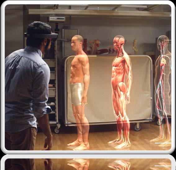
10 A Model A representation of some key aspects of the subject Captures the essential aspects of the subject May not represent other aspects well May have some simplifications or generalizations


11 Model Examples Schematics diagram of a physical network - Simplified/generalized - Misrepresents some aspects, e.g. distances, locations - Captures the connectivity


12 Model Examples Mathematical models See:


13 Model Examples Physical models A 3D printer See:


14 Model Examples Terrain Model


15 Model Examples Solid Terrain Modeling ( Sand Table by Simtable (


16 Model Examples Touch table 3D Topographic Map Table by Applied Minds and Northrop Grumman


17 Model Examples Vehicles Human figures Plants


18 Acquiring Digital Models Digitizing/Scanning - LiDar - Sonar - Manual Digital Sculpting Automatically generated - Stereo fusion - Procedural Motion Capture:
19 Model Behaviors Controlled by human - using input from hardware Controlled by software a model may be controlled by other models - Artificial Intelligence - Mathematical model (e.g. Physics model)


20 Simulation
21 Simulation An execution of a model over time Resides on the implementation level
22 Why using Simulations Are cheaper and safer than - Actual exercises - Physical prototypes Are more realistic than traditional experiments Can be conducted faster or slower than real time Allow setting up a coherent synthetic environment
23 Simulation Advantages Players can practice in a safe, protected environment Players can interact among one another Players may be: - Human, computer controlled or mixed Observers can observe without distracting the players Supervisors can assist, guide, assess Scene/scenarios can be selected or adjusted - Supports what-if Repeatable Comparable - E.g. compared with previous runs
24 Elements of Simulation Process - weather, traffic, lighting, wind Procedure - steps of operation Subject - things to practice on Source: Meller G. A typology of simulators for medical education. J Digital Imaging, 1997 Aug: 10
 Interactive - Elements change in response to player, e.g. agent-based, AI")
25 Type of Simulators Passive - Provides element of realism scene decorators, base-map Active - Elements change over time - Changes driven by: - Sequence of snapshots - Calculations - Combination of the above (e.g. tweening, dead-reckoning, interpolation) Interactive - Elements change in response to player, e.g. agent-based, AI


26 Fidelity of Simulation Low fidelity - Simple simulation - Individual player - Involves only a few elements - Focus on specific subject High fidelity - Complex simulation - Involves many elements, passive, active, and interactive - Involves many subject matter experts - Involves many players Adapted from:
27 Collecting Data for Simulation Project Too many data points will overload the system - Poor performance - Require hardware sizing adequately - NVIDIA Quadro K6000 with cores, $4, Storage capacity - Data communication bandwidth Sparse data points - Reduce fidelity of the representation and simulation - Not enough realism


28 System Components


29 Inputs Keyboard Mouse Touch screen Joystick Steering wheel Weapon interface Eye/head tracking Motion/Gesture - Kinect - Leap Motion - Myo Armband Microphone


30 Inputs IoT Sensors Air quality airqualityegg.com Atmospheric Pressure pressurenet.io CO2 Temperature Humidity Light Sound


31 Outputs 3D Visualization - Head-mounted Display - Monitors - Projectors - Hologram 3D Sounds - Speakers, headphones Haptic Scent Air flow


32 Integrated Inputs and Outputs


33 Environment/Platform Touch table Sand table CAVE - Northrop Grumman VIPE Holodeck Source: Source:
 - Data logger/recorder Real-time analytics - Geofencing - Trigger -")
34 Software Components Modeling - Scene/Environment authoring - 3D base-maps - Behavior control simulation engine - Repast/ArcGIS Agent Analyst - NetLogo/AgenScript - Swarm - Agent-based Modeling (ABM) - Data logger/recorder Real-time analytics - Geofencing - Trigger - Alert -
 IEEE 1516 - Test and Training Enabling Architecture (TENA) - Real-time data streaming - Positions - Orientations -")
 Your Applications Send Features to a Stream Service Feature")
35 Data Communication Communication protocols - Distributed Interactive Simulation (DIS) IEEE High Level Architecture (HLA) IEEE Test and Training Enabling Architecture (TENA) - Real-time data streaming - Positions - Orientations - States Messaging Time synchronization ArcGIS Server GeoEvent Extension Update a Feature Add a Feature feature layers Map Services Feature Services Stream Services EGDB Polling (Pull) Your Applications Send Features to a Stream Service Feature Layer Stream Layer

36 Simulation Authoring Unit/Track creation - Unit catalog - Map/Scene - Drag and drop unit onto map - Track authoring - Unit type - Terrain factor, e.g. elevation, slope, type of ground cover Track playback tool Tracks orchestration - Timeline placement - Time synchronization Simulation recording tool


37 Questions and Answers
38 Selected 3D Sessions 3D Analysis: An Overview - Tue 7/21/ :30 AM - 09:45 AM Room 10 - Thu 7/23/ :30 AM - 09:45 AM Ballroom 06 E 3D Cartographic Techniques: An Introduction - Tue 7/21/ :30 AM - 09:45 AM Room 31 B - Thu 7/23/ :15 PM - 04:30 PM Room 17 A Creating 3D Campuses - Tue 7/21/ :15 PM - 04:30 PM Room 14 A 3D Analyst: An Introduction - Wed 7/22/ :30 AM - 09:45 AM Room 02 ArcGIS API for JavaScript: Building 3D Web Apps - Wed 7/22/ :30 AM - 09:45 AM Room 10
39 Selected 3D Sessions Working with 3D Analyst and CityEngine - Wed 7/22/ :30 AM - 09:45 AM Room 14 A ArcGIS for 3D Cities: An Introduction - Wed 7/22/ :30 PM - 02:45 PM Room 15 A - Thu 7/23/ :30 PM - 02:45 PM Room 05 B Advanced workflows for creating 3D Web Scenes in ArcGIS Online - Wed 7/22/ :15 PM - 04:30 PM Room 14 B Sharing 3D Content on the Web - Wed 7/22/ :15 PM - 04:30 PM Room 15 A
40 Real-Time GIS Sessions Real-Time GIS: GeoEvent Extension - Tue 10:15-11:30am, Room 17 A - Wed 10:15-11:30am, Room 14 B Real-Time GIS: Leveraging Stream Services - Tue 8:30-9:45am, Room 01 A/B - Wed 8:30-9:45am, Ballroom 06 D Real-Time GIS: Applying Real-Time Analytics - Tue 10:15-11:30am, Room 15 B - Wed 8:30-9:45am, Room 14 B Real-Time GIS Use Cases and Implementation Patterns - Tue 2:30-3:15PM, Demo Theater 6 - Geodata ArcGIS Intelligence: Discern Activities of Interest through Advanced Analytics - Wed 10:15-11:30am, Omni Ballroom A/B Real-Time GIS: The Road Ahead - Wed 1:30-2:45pm, Room 14 B Real-Time GIS: Best Practices - Thu 8:30-9:45am, Room 14 B Real-Time GIS for Asset Readiness, Event Preparation, and Intervention - Thu 8:30-9:45am, Room 29 C


41
ArcGIS GeoEvent Server: Making 3D Scenes Come Alive with Real-Time Data
 ArcGIS GeoEvent Server: Making 3D Scenes Come Alive with Real-Time Data Morakot Pilouk, Ph.D. Senior Software Developer, Esri mpilouk@esri.com @mpesri Agenda 1 2 3 4 5 6 3D for ArcGIS Real-Time GIS Static
Real-Time GIS: GeoEvent Extension
 Real-Time GIS: GeoEvent Extension Greg Tieman gtieman@esri.com RJ Sunderman rsunderman@esri.com What is Real-Time GIS? GIS Data What has happened, what is happening, what will happen Credit: istockphoto/chris_lemmens
GeoEvent Server: Introduction
 GeoEvent Server: Introduction Josh Joyner GeoEvent Server, Product Manager jjoyner@esri.com Sagar Ayare Real-Time GIS Product Engineer sayare@esri.com @thetechiesagar Agenda 1 2 3 4 5 What is Real-Time
ArcGIS GeoEvent Server: Leveraging Stream Services. Ken Gorton RJ Sunderman
 ArcGIS GeoEvent Server: Leveraging Stream Services Ken Gorton RJ Sunderman Agenda 1 2 3 4 5 Overview of Stream Services & Stream Layers Publishing Stream Services Visualization of real-time data Sample
GeoEvent Server Introduction
 GeoEvent Server Introduction RJ Sunderman Real-Time GIS Product Engineer rsunderman@esri.com Sagar Ayare Real-Time GIS Product Engineer sayare@esri.com Agenda 1 2 3 4 5 What is Real-Time GIS? Working with
Creating and Maintaining Your 3D Basemap. Brian Sims Dan Hedges Gert van Maren
 Creating and Maintaining Your 3D Basemap Brian Sims Dan Hedges Gert van Maren Complementary Resource Email (no marketing) A copy of the presentation Links to today s web demos Links to training materials
GeoEvent Server: An Introduction. Adam Ziegler, Solution Engineer
 GeoEvent Server: An Introduction Adam Ziegler, Solution Engineer Agenda 1 2 3 4 5 What is Real-Time GIS? Working with Real-Time Data Applying Real-Time Analytics Visualizing Real-Time Data Wrap-up 1 What
Real-Time GIS: Leveraging Stream Services
 Real-Time GIS: Leveraging Stream Services Mark Bramer Senior Technical Analyst Esri Professional Services mbramer@esri.com RJ Sunderman Product Engineer GeoEvent Extension Product Team rsunderman@esri.com
Real-Time & Big Data GIS: Leveraging the spatiotemporal big data store
 Real-Time & Big Data GIS: Leveraging the spatiotemporal big data store Suzanne Foss Product Manager, Esri sfoss@esri.com Ricardo Trujillo Real-Time & Big Data GIS Developer, Esri rtrujillo@esri.com @rtrujill007
ArcGIS GeoEvent Server: Real-Time GIS
 ArcGIS GeoEvent Server: Real-Time GIS Anthony Myers Local Government Solutions Engineer Kevin Armstrong Public Safety Solutions Engineer E M E R A L D S A P P H I R E T H A N K Y O U T O O UR SPONSORS
Building Great Situational Awareness Apps Using ArcGIS Developer Tools. Kerry Robinson Eric Bader Thomas Solow
 Building Great Situational Awareness Apps Using ArcGIS Developer Tools Kerry Robinson Eric Bader Thomas Solow Agenda Situational Awareness in ArcGIS Developing apps in connected environments - ArcGIS Enterprise
GeoEvent Server: An Introduction. Josh Joyner RJ Sunderman
 : An Introduction Josh Joyner RJ Sunderman Agenda: 1 2 3 4 5 Key Product Capabilities Working with Real-Time Data Demo: Vehicle Location and Alert Monitoring Consuming Real-Time Data Wrap-up Real-Time
Monitoring Your Operations David Jacob
 Monitoring Your Operations David Jacob Jeff Shaner Real-time data Vessels Vehicles Sensors Weather People Challenge of Real-time data How do I visualize real-time data? How can I process and analyze it?
Mobile Mapping and Navigation. Brad Kohlmeyer NAVTEQ Research
 Mobile Mapping and Navigation Brad Kohlmeyer NAVTEQ Research Mobile Mapping & Navigation Markets Automotive Enterprise Internet & Wireless Mobile Devices 2 Local Knowledge & Presence Used to Create Most
What s New in ArcGIS 10.3 for Server. Tom Shippee Esri Training Services
 What s New in ArcGIS 10.3 for Server Tom Shippee Esri Training Services Today s Agenda What is ArcGIS for Server at 10.3 - ArcGIS Platform story - Expanding ArcGIS for Server paradigm What s new in ArcGIS
Real-Time GIS: Applying Real-Time Analytics
 Real-Time GIS: Applying Real-Time Analytics RJ Sunderman GeoEvent Server Product Engineer, Esri rsunderman@esri.com Ken Gorton Real-time/Big Data Product Engineer, Esri kgorton@esri.com Agenda 1 2 3 4
ArcGIS Server and Portal for ArcGIS An Introduction to Security
 ArcGIS Server and Portal for ArcGIS An Introduction to Security Jeff Smith & Derek Law July 21, 2015 Agenda Strongly Recommend: Knowledge of ArcGIS Server and Portal for ArcGIS Security in the context
Using Operations Dashboard for ArcGIS: An Introduction
 FedGIS Conference February 24 25, 2016 Washington, DC Using Operations Dashboard for ArcGIS: An Introduction Ken Gorton Carmella A. Burdi, GISP Solution Engineer Esri National Government Team kgorton@esri.com
ArcGIS for Intelligence: Discern Activities of Interest Through Advanced Analysis. Natalie Feuerstein Ben Conklin Lyle Wright
 ArcGIS for Intelligence: Discern Activities of Interest Through Advanced Analysis Natalie Feuerstein Ben Conklin Lyle Wright Challenges Demo Movement Pattern Dashboard Key Concepts New Analytic Workflow
3D in the ArcGIS Platform. Chris Andrews
 3D in the ArcGIS Platform Chris Andrews Geospatial 3D is already all around us 3D is expanding the GIS community s opportunity to provide value 3D City & Infrastructure Models Generated 3D features Photogrammetrc
GeoEvent Server: Creating Connectors and Processors Using the GeoEvent SDK
 GeoEvent Server: Creating Connectors and Processors Using the GeoEvent SDK Javier Delgadillo Real-Time GIS Developer, Esri jdelgadillo@esri.com Ming Zhao Real-Time GIS Developer, Esri mzhao@esri.com Agenda
ArcGIS GeoEvent Server: Leveraging Stream Services
 ArcGIS GeoEvent Server: Leveraging Stream Services James Cardona Web Developer DC R&D Center Tysons jcardona@esri.com RJ Sunderman GeoEvent Server Real-Time Capabilities rsunderman@esri.com Agenda Overview
What Is a Distributed Simulation (i.e., A Federation)?
?") M&S VV&A RG Core Document: VV&A of Federations What Is a Distributed Simulation (i.e., A Federation)? 1/31/2011 A distributed simulation is defined as a disparate set of models and/or simulations operating
M&S VV&A RG Core Document: VV&A of Federations What Is a Distributed Simulation (i.e., A Federation)? 1/31/2011 A distributed simulation is defined as a disparate set of models and/or simulations operating
Connecting Space and Time OSIsoft & Esri
 Connecting Space and Time OSIsoft & Esri Presented by Michelle Kuiee Product Manager Frank Batke Senior Systems Engineer 2 Which of these describe your need? Operating Engineers & Analysts Environmental
V-Sentinel: A Novel Framework for Situational Awareness and Surveillance
 V-Sentinel: A Novel Framework for Situational Awareness and Surveillance Suya You Integrated Media Systems Center Computer Science Department University of Southern California March 2005 1 Objective Developing
ArcGIS for Server: What s New. Philip Heede, Jay Theodore
 ArcGIS for Server: What s New Philip Heede, Jay Theodore Agenda GIS server Web GIS: Portal for ArcGIS ArcGIS for Server Extensions - GeoEvent Extension - Production Mapping Primary target for new functionality
Real-Time GIS: The Internet of Things (IoT)
") Esri Developer Summit March 8 11, 2016 Palm Springs, CA Real-Time GIS: Morakot Pilouk, Ph.D. Senior Software Developer, Esri mpilouk@esri.com @mpesri Ming Zhao Real-Time GIS Developer, Esri mzhao@esri.com
Esri Developer Summit March 8 11, 2016 Palm Springs, CA Real-Time GIS: Morakot Pilouk, Ph.D. Senior Software Developer, Esri mpilouk@esri.com @mpesri Ming Zhao Real-Time GIS Developer, Esri mzhao@esri.com
ArcGIS Runtime SDK for ios and macos: Building Apps. Suganya Baskaran, Gagandeep Singh
 ArcGIS Runtime SDK for ios and macos: Building Apps Suganya Baskaran, Gagandeep Singh Get Started Core Components Agenda - Display Map Content - Search for Content - Perform Analysis - Edit Content Summary
Network Analyst: An Introduction
 2013 Esri International User Conference July 8 12, 2013 San Diego, California Technical Workshop Network Analyst: An Introduction Patrick Stevens Robert Garrity Esri UC2013. Technical Workshop. Introduction
Making the Most of Raster Analysis with Living Atlas Data. Aileen Buckley, PhD, Research Cartographer Esri - Redlands
 Making the Most of Raster Analysis with Living Atlas Data Aileen Buckley, PhD, Research Cartographer Esri - Redlands Spatial Analysis with Online Data Your Desktop Web Device Never scrounge for or download
Modeling and Simulation Body of Knowledge (M&SBOK) - Index
 - Index") Modeling and Simulation Body of Knowledge (M&SBOK) - Index updated and by: Dr. Tuncer Ören - 2010-12-17 Terminology: Types of Data & Terms Related with Data (based on the first version of the Multi-lingual
Modeling and Simulation Body of Knowledge (M&SBOK) - Index updated and by: Dr. Tuncer Ören - 2010-12-17 Terminology: Types of Data & Terms Related with Data (based on the first version of the Multi-lingual
Building Real-Time Web Applications Using ArcGIS GeoEvent Processor
 Building Real-Time Web Applications Using ArcGIS GeoEvent Processor Ryan Elliott Software Engineer ArcGIS GeoEvent Processor for Server relliott@esri.com James Cardona Web Developer DC Development Center
Developing Real-Time Web Mapping Applications
 Developing Real-Time Web Mapping Applications Adam Mollenkopf, Solutions Product Manager Morakot Pilouk, Senior Software Consultant Hanoch Kalmanovich, Tracking Development Lead Agenda Real-Time Web Mapping
ArcGIS GeoEvent Extension for Server: The Internet of Things (IoT)
") ArcGIS GeoEvent Extension for Server: The Internet of Things (IoT) C. Adam Mollenkopf Product Lead ArcGIS GeoEvent Extension for Server amollenkopf@esri.com @amollenkopf Morakot Pilouk, PhD Senior Consultant
ArcGIS GeoEvent Extension for Server: The Internet of Things (IoT) C. Adam Mollenkopf Product Lead ArcGIS GeoEvent Extension for Server amollenkopf@esri.com @amollenkopf Morakot Pilouk, PhD Senior Consultant
Dynamic Adaptive Disaster Simulation: A Predictive Model of Emergency Behavior Using Cell Phone and GIS Data 1
 Dynamic Adaptive Disaster Simulation: A Predictive Model of Emergency Behavior Using Cell Phone and GIS Data 1, Zhi Zhai, Greg Madey Dept. of Computer Science and Engineering University of Notre Dame Notre
Building Real Time Web Applications with GeoEvent Processor. Ken Gorton, Esri
 Building Real Time Web Applications with GeoEvent Processor Ken Gorton, Esri Agenda An example of how real-time streaming data could save your life Brief intro to Geoevent Processor Some useful GEP outputs
Lab 1: Introductory Project to Breadware
 1 Lab 1: Introductory Project to Breadware Exploration of Breadware s IoT Development Tools Overview The goal of this lab is to become familiar with the Internet of Things prototyping tools available in
Surface Analysis with 3D Analyst
 2013 Esri International User Conference July 8 12, 2013 San Diego, California Technical Workshop Surface Analysis with 3D Analyst Khalid H. Duri Esri UC2013. Technical Workshop. Why use 3D GIS? Because
Introduction to Web AppBuilder for ArcGIS: JavaScript Apps Made Easy
 Introduction to Web AppBuilder for ArcGIS: JavaScript Apps Made Easy Jianxia Song & Derek Law July 21, 2015 Agenda Product overview Web AppBuilder for ArcGIS tour What s New July 2015 ArcGIS Online update
rfpro & DS Products: Integrated development software for human and autonomously driven vehicles
 rfpro & DS Products: Integrated development software for human and autonomously driven vehicles rfpro & DS Products: Integrated development software for human andautonomously driven vehicles rfpro The
Khronos and the Mobile Ecosystem
 Copyright Khronos Group, 2011 - Page 1 Khronos and the Mobile Ecosystem Neil Trevett VP Mobile Content, NVIDIA President, Khronos Copyright Khronos Group, 2011 - Page 2 Topics It s not just about individual
Lidar and GIS: Applications and Examples. Dan Hedges Clayton Crawford
 Lidar and GIS: Applications and Examples Dan Hedges Clayton Crawford Outline Data structures, tools, and workflows Assessing lidar point coverage and sample density Creating raster DEMs and DSMs Data area
Getting Started with ArcGIS for Server. Charmel Menzel and Ken Gorton
 Getting Started with ArcGIS for Server Charmel Menzel and Ken Gorton Agenda What is ArcGIS for Server? Types of Web services Publishing resources onto the Web Clients to ArcGIS for Server Editions and
An Introduction to Using Lidar with ArcGIS and 3D Analyst
 FedGIS Conference February 24 25, 2016 Washington, DC An Introduction to Using Lidar with ArcGIS and 3D Analyst Jim Michel Outline Lidar Intro Lidar Management Las files Laz, zlas, conversion tools Las
Advanced Parcel Editing. Amy Andis Tim Hodson
 Advanced Parcel Editing Amy Andis Tim Hodson Overview What to expect in this technical workshop Review of the Parcel Fabric Data Model Advanced Tips and tricks for Parcel entry Assessing Quality of Parcel
By: Computer Education. Introduction Level One
 Computer Education Introduction Level One What is a Computer? A computer is an electronic machine which can take in data, stores and processed the data, and then produces information Data is information
Real-Time & Big Data GIS: Best Practices. Suzanne Foss Josh Joyner
 Real-Time & Big Data GIS: Best Practices Suzanne Foss Josh Joyner ArcGIS Enterprise With Real-time Capabilities Desktop Apps APIs visualization ingestion dissemination & actuation analytics storage Agenda:
Introduction to Cisco IoT Tools for Developers IoT 101
 Introduction to Cisco IoT Tools for Developers IoT 101 Mike Maas, Technical Evangelist, IoT, DevNet Angela Yu, Technical Leader DEVNET-1068 Agenda The Cisco IoT System Distributing IoT Applications Developer
8.3 Networked Application. History and Evolution. U.S. Department of Defense (DoD) SIMNET NSA. i. Object-Event Architecture
 SIMNET NSA. i. Object-Event Architecture") 8.3 Networked Application Department of Defense (DoD) SIMNET Distributed Interactive Simulation (DIS) High-Level Architecture (HLA) Academic NVEs PARADISE DIVE BrickNet other academic projects Networked
8.3 Networked Application Department of Defense (DoD) SIMNET Distributed Interactive Simulation (DIS) High-Level Architecture (HLA) Academic NVEs PARADISE DIVE BrickNet other academic projects Networked
USING THE VIRTUAL REALITY SYSTEM IN THE DEVELOPMENT OF AIRCRAFT ENGINE
 IN THE DEVELOPMENT OF AIRCRAFT ENGINE I. Svadkovskiy, L. Zhemuranova Central Institute of Aviation Motors, Russia igor@ciam.ru, lzhemuranova@ciam.ru Keywords: VR, jet engines development, virtual prototype
ROAD SURFACE STRUCTURE MONITORING AND ANALYSIS USING HIGH PRECISION GPS MOBILE MEASUREMENT SYSTEMS (MMS)
") ROAD SURFACE STRUCTURE MONITORING AND ANALYSIS USING HIGH PRECISION GPS MOBILE MEASUREMENT SYSTEMS (MMS) Bonifacio R. Prieto PASCO Philippines Corporation, Pasig City, 1605, Philippines Email: bonifacio_prieto@pascoph.com
ROAD SURFACE STRUCTURE MONITORING AND ANALYSIS USING HIGH PRECISION GPS MOBILE MEASUREMENT SYSTEMS (MMS) Bonifacio R. Prieto PASCO Philippines Corporation, Pasig City, 1605, Philippines Email: bonifacio_prieto@pascoph.com
Apple Carplay. The Connected Car. AppRadioLIVE. Android Auto
 Pioneer's NEX or Networked Entertainment experience line of receivers features an innovative and powerful new user interface that is responsive and highly customizable. The NEX models are designed especially
Sharing 3D Content on the Web
 Sharing 3D Content on the Web Nathan Shephard, Gert van Maren Why 3D GIS? Because our world is 3D Improve understanding 3D is easy for everyone to understand Better communication 3D makes it easier to
ArcGIS Enterprise: Portal Administration BILL MAJOR CRAIG CLEVELAND
 ArcGIS Enterprise: Portal Administration BILL MAJOR CRAIG CLEVELAND Agenda Welcome & Introduction to ArcGIS Enterprise Portal for ArcGIS - Basic Configuration - Advanced Configuration - Deploying Apps
ICAP - Intelligence Configuration for ArcGIS Pro. Natalie Feuerstein Dan Barnes Joe Bayles
 ICAP - Intelligence Configuration for ArcGIS Pro Natalie Feuerstein Dan Barnes Joe Bayles Overview Intelligence Analyst supporting Operations ArcGIS Pro SDK Intelligence Configuration for ArcGIS Pro -
Spatial Analyst Identifying the Best Paths with Cost Distance Analysis. Kevin M. Johnston Elizabeth Graham
 Spatial Analyst Identifying the Best Paths with Cost Distance Analysis Kevin M. Johnston Elizabeth Graham Cost distance analysis - Outline What is cost distance analysis Creating a cost surface Cost Analysis
INTERIOARCH SOLUTIONS AUDIO VIDEO SYSTEM
 INTERIOARCH SOLUTIONS AUDIO VIDEO SYSTEM PRO AV AND HOME AV SYSTEMS AV AUTOMATION AND CONTROL VIDEO AND AUDIO CONFERENCING DIGITAL SIGNAGE INTERACTIVE AND LEARNING TECHNOLOGIES PROJECTION LED, LCD AND
ArcGIS GeoEvent Server Overview. Thomas Paschke
 ArcGIS GeoEvent Server Overview Thomas Paschke Agenda 1 2 3 4 5 6 GeoEvent Development GeoEvent Server Real-Time & Big Data @ 10.5.x Visualization Road Ahead (10.6) R&D Project Trinity & Other 1 GeoEvent
Developing 2D and 3D Applications for Real-Time Visualization and Analysis
 Developing 2D and 3D Applications for Real-Time Visualization and Analysis Morakot Pilouk Hanoch Kalmanovich Ryan Elliott ESRI Developer Summit 2008 1 Outline Introduction ESRI Technologies for Real-time
Real-Time Insights from the Source
 LATENCY LATENCY LATENCY Real-Time Insights from the Source This white paper provides an overview of edge computing, and how edge analytics will impact and improve the trucking industry. What Is Edge Computing?
Working with Scientific Data in ArcGIS Platform
 Working with Scientific Data in ArcGIS Platform Sudhir Raj Shrestha sshrestha@esri.com Hong Xu hxu@esri.com Esri User Conference, San Diego, CA. July 11, 2017 What we will cover today Scientific Multidimensional
ArcGIS Runtime SDK for Qt: Building Apps. Koushik Hajra and Lucas Danzinger
 ArcGIS Runtime SDK for Qt: Building Apps Koushik Hajra and Lucas Danzinger Cross-platform apps Agenda for today Intro to Qt Framework and ArcGIS Runtime SDK for Qt App design patterns with this SDK SDK
WINGS AVIO NODE BASED, DE-CENTRALIZED SHOW CONTROL. Interface. Script. Data. Distribution.
 WINGS AVIO NODE BASED, DE-CENTRALIZED SHOW CONTROL Interface. Script. Data. Distribution. WHAT IS AVIO? Simple. Clever. Stable. Avio is a network protocol and sophisticated show control logic system developed
ArcGIS GeoEvent Processor for Server. Jayson Hagen & Bryan Franey
 ArcGIS GeoEvent Processor for Server Jayson Hagen & Bryan Franey ArcGIS GeoEvent Processor for Server Agenda Real-time GIS Overview Working with real-time data Performing continuous processing and analysis
ArcGIS Pro Tasks: An Introduction. Jason Camerano Amir Bar-Maor
 ArcGIS Pro Tasks: An Introduction Jason Camerano Amir Bar-Maor Live Call With Esri Technical Support Esri Technical support: Jason Customer: Amir Warning: there is a test in the end of the presentation
Network Analysis with ArcGIS Online and On-premise Services
 2013 Esri International User Conference July 8 12, 2013 San Diego, California Technical Workshop Network Analysis with ArcGIS Online and On-premise Services Deelesh Mandloi Dmitry Kudinov Esri UC2013.
Feature Extraction from Imagery & Lidar. Kurt Schwoppe, Esri Mark Romero, Esri Gregory Bacon, Fairfax County
 Feature Extraction from & Lidar Kurt Schwoppe, Esri Mark Romero, Esri Gregory Bacon, Fairfax County Today s Speakers Image Processing Experts and Good Colleagues Kurt Schwoppe Industry Lead Esri Mark Romero
Missile Simulation in Support of Research, Development, Test Evaluation and Acquisition
 NDIA 2012 Missile Simulation in Support of Research, Development, Test Evaluation and Acquisition 15 May 2012 Briefed by: Stephanie Brown Reitmeier United States Army Aviation and Missile Research, Development,
Networked Virtual Environments
 Special Course on Networked Virtual Jouni Smed Turku Centre for Computer Science (TUCS) Department of Information Technology, University of Turku 2004 Course Syllabus credits: 2 cu prerequisites: knowledge
ArcGIS Viewer for Microsoft Silverlight An Introduction
 Esri International User Conference San Diego, CA Technical Workshops July 12, 2011 ArcGIS Viewer for Microsoft Silverlight An Introduction Art Haddad, Rich Zwaap, and Derek Law Agenda Background Product
Autorama, Connecting Your Car to
 Autorama, Connecting Your Car to the Internet of Tomorrow Nicholas Sargologos, Senior Marketing Manager, Digital Networking Freescale Semiconductor Overview Automotive OEMs need a secure, managed process
Drone2Map for ArcGIS: Bring Drone Imagery into ArcGIS
 Drone2Map for ArcGIS: Bring Drone Imagery into ArcGIS Mike Sweeney 1 Drone2Map for ArcGIS Turn Drones into Enterprise Productivity Tools ArcGIS Drone2Map for ArcGIS Create 2D and 3D products from raw drone
ANIMS-Phase 2. IntuiLab Intactile DESIGN. Eurocontrol CARE INO II programme
 ANIMS-Phase 2 IntuiLab Intactile DESIGN Eurocontrol CARE INO II programme Introduction The ANIMS project is carried out in collaboration between the Eurocontrol agency, researchers in user interfaces from
Introduction to ArcGIS API for Flex. Bjorn Svensson Lloyd Heberlie
 Introduction to ArcGIS API for Flex Bjorn Svensson Lloyd Heberlie Agenda API Introduction Getting started API concepts and examples Getting more information API Introduction ArcGIS 10 A Complete System
Collector for ArcGIS: What s New. Chris LeSueur & James Tedrick
 Collector for ArcGIS: What s New Chris LeSueur & James Tedrick Outline Product overview Workflows Preparing data for Collector for ArcGIS What s new in Collector for ArcGIS v18.1.0 (Aurora) Advanced topics
ArcGIS GeoEvent Server REALTIME GIS. Jay Fowler Solution Engineer
 ArcGIS GeoEvent Server REALTIME GIS Jay Fowler Solution Engineer GOLD S I L V E R T H A N K Y O U T O O UR SPONSORS Agenda REALTIME GIS Intro Real-Time GIS Overview Act I Hop on the bus Act II Radar Love
Simulation: A Must for Autonomous Driving
 Simulation: A Must for Autonomous Driving NVIDIA GTC 2018 (SILICON VALLEY) / Talk ID: S8859 Rohit Ramanna Business Development Manager Smart Virtual Prototyping, ESI North America Rodolphe Tchalekian EMEA
Lesson 9 Smart city Services And Monitoring. Chapter-12 L09: "Internet of Things ", Raj Kamal, Publs.: McGraw-Hill Education
 Lesson 9 Smart city Services And Monitoring 1 Tech-Mahindra partnering with ThingWorx Smart City Solutions Smart traffic solutions Smart energy management Smart parking, Smart waste bins Smart street lighting
nüvi 860 Safer handsfree operation Touch-free phone calls Part Number:
 nüvi 860 Part Number: 010-00577-01 The widescreen nüvi 860 combines true voice control with premium navigation. This intelligent sat-nav is the first with full menu voice activation, which means there
Tracking Requirements for ATC Tower Augmented Reality Environments
 Tracking Requirements for ATC Tower Augmented Reality Environments Magnus Axholt Department of Science and Technology (ITN) Linköping University, Sweden Supervisors: Anders Ynnerman Linköping University,
Esri UC2013. Technical Workshop. Type Presentation Name Here
 Type Presentation Name Here 2013 Esri International User Conference July 8 12, 2013 San Diego, California Technical Workshop 3D Analyst An Introduction Deepinder Deol Michael Contreras Why use 3D GIS?
Knight Library 106 Browsing Room
 1 Knight Library 106 Browsing Room Technology Tutorial 1. Turn the projector on a. In the upper right-hand corner of the touch panel, press the power button to wake the screen. b. Then, select the Projector
Features: (no need for QR Code)
") The Capp-Sure series brings a revolution in surveillance. Utilising a range of high-quality IP Wireless cameras, Capp-Sure provides stunning video clarity and optional Talk-Back audio over internet via
The Capp-Sure series brings a revolution in surveillance. Utilising a range of high-quality IP Wireless cameras, Capp-Sure provides stunning video clarity and optional Talk-Back audio over internet via
Ubiquitous IoT Perspectives The Power of Connected Sensors and Actuators
 Ubiquitous IoT Perspectives The Power of Connected Sensors and Actuators Andrea Onetti Vice President, General Manager MEMS Sensor Division STMicroelectronics Digital Technologies are Transforming nearly
Chris Rotondo, GIS Specialist. Prince George s County Planning Department The Maryland-National Capital Park and Planning Commission
 Chris Rotondo, GIS Specialist Prince George s County Planning Department The Maryland-National Capital Park and Planning Commission MSGIC, July 2015 A 150-page report on implementing 3D technology, prepared
Connected Car. Dr. Sania Irwin. Head of Systems & Applications May 27, Nokia Solutions and Networks 2014 For internal use
 Connected Car Dr. Sania Irwin Head of Systems & Applications May 27, 2015 1 Nokia Solutions and Networks 2014 For internal use Agenda Introduction Industry Landscape Industry Architecture & Implications
Advanced Driver Assistance: Modular Image Sensor Concept
 Vision Advanced Driver Assistance: Modular Image Sensor Concept Supplying value. Integrated Passive and Active Safety Systems Active Safety Passive Safety Scope Reduction of accident probability Get ready
Architect your deployment using Chef
 ArcGIS Enterprise Architect your deployment using Chef Cherry Lin and Scott MacDonald ArcGIS Enterprise base deployment Why automate your ArcGIS Enterprise deployment? Efficiency Get up and running faster
E3De. E3De Discover the Next Dimension of Your Data.
 International Support Exelis Visual Information Solutions is a global company with direct offices in North America, Europe, and Asia. Combined with our extensive, worldwide distributor network, we can
Part I: Introduction to Wireless Sensor Networks. Xenofon Fafoutis
 Part I: Introduction to Wireless Sensor Networks Xenofon Fafoutis Sensors 2 DTU Informatics, Technical University of Denmark Wireless Sensor Networks Sink Sensor Sensed Area 3 DTU Informatics,
Standardized Data Production Strategies Across Your Enterprise
 Federal GIS Conference February 9 10, 2015 Washington, DC Standardized Data Production Strategies Across Your Enterprise Amber Bethell Sherry Fagin Authoritative content producers Knowledge Workers Executive
See What We See - Sharing Mixed Reality Experiences with WebRTC
 See What We See - Sharing Mixed Reality Experiences with WebRTC Jonathan Reeves October 9, 2017 1 Introduction Mixed Reality is a game changing technology for enterprises including AEC, education, energy,
Realtime Object Detection and Segmentation for HD Mapping
 Realtime Object Detection and Segmentation for HD Mapping William Raveane Lead AI Engineer Bahram Yoosefizonooz Technical Director NavInfo Europe Advanced Research Lab Presented at GTC Europe 2018 AI in
Korea ICT Market Overview. Yoonmi Kim Finpro Korea
 Korea ICT Market Overview Yoonmi Kim Finpro Korea 5G Advanced Network Key Players Network Service Provider Electronics Company Car and Car Component Company - 5G Antenna Technoloies for Mobile device and
CHARLES DARWIN, CYBERSECURITY VISIONARY
 SESSION ID: SPO1-W12 CHARLES DARWIN, CYBERSECURITY VISIONARY Dan Schiappa SVP and GM, Products Sophos @dan_schiappa It is not the strongest of the species that survives, nor the most intelligent that survives.
Creating Apps Using ArcGIS Online Templates. Matt Kennedy
 Creating Apps Using ArcGIS Online Templates Matt Kennedy Topics we will cover The publishing process Before you publish Where apps live Breakdown of apps Publishing web app templates The steps for publishing
Outline Sensors. EE Sensors. H.I. Bozma. Electric Electronic Engineering Bogazici University. December 13, 2017
 Electric Electronic Engineering Bogazici University December 13, 2017 Absolute position measurement Outline Motion Odometry Inertial systems Environmental Tactile Proximity Sensing Ground-Based RF Beacons
Towards Fully-automated Driving. tue-mps.org. Challenges and Potential Solutions. Dr. Gijs Dubbelman Mobile Perception Systems EE-SPS/VCA
 Towards Fully-automated Driving Challenges and Potential Solutions Dr. Gijs Dubbelman Mobile Perception Systems EE-SPS/VCA Mobile Perception Systems 6 PhDs, 1 postdoc, 1 project manager, 2 software engineers
Visualisation : Lecture 1. So what is visualisation? Visualisation
 So what is visualisation? UG4 / M.Sc. Course 2006 toby.breckon@ed.ac.uk Computer Vision Lab. Institute for Perception, Action & Behaviour Introducing 1 Application of interactive 3D computer graphics to
Data Interoperability Advanced Use
 Data Interoperability Advanced Use Bruce Harold Dale Lutz bharold@esri.com Safe Software This is your world ask us today about best practices Automate Moving Data No Domain Limitations ArcGIS Data Interoperability