ArcGIS GeoEvent Server: Real-Time GIS
|
|
|
- Lily Green
- 5 years ago
- Views:
Transcription


1 ArcGIS GeoEvent Server: Real-Time GIS Anthony Myers Local Government Solutions Engineer Kevin Armstrong Public Safety Solutions Engineer


2 E M E R A L D S A P P H I R E T H A N K Y O U T O O UR SPONSORS
3 Agenda What is Real-Time GIS? Working with Real-Time Data Applying Real-Time Analytics Integrating Real-Time Data in Web Apps Wrap-up

4 ArcGIS Enterprise Web Device Desktop GeoEvent Server Real-time and big-data capabilities Ingest high velocity real-time data into ArcGIS Perform continuous analytics on events as they are received live features live & historic aggregates & features Store observations in a spatiotemporal big data store Run batch analytics on stored observations Visualize high velocity & volume data: - as an aggregation - as discrete features ingestion analytics stream service visualization ArcGIS Enterprise map & feature service analytics Notify those who need to know about patterns of interest GeoEvent Server spatiotemporal big data store storage GeoAnalytics Server GeoEvent Server is a server role extending the capabilities of your ArcGIS Enterprise
5 1 What is Real-Time GIS


6 GIS Data What has happened, what is happening, what will happen Credit: istockphoto/chris_lemmens The current snapshot is outdated almost as soon as it s created


7 Real-Time GIS Data Continuous stream of events flowing from a data feed Features Police Car Police Person Ambulance Network Sensor Warehouse Item Applications Storm 110 Wind Temperature Earthquake Wild Fire Each event represents the latest state of the sensor

8 Real-Time Analytics What fishing vessels are inside designated no fishing zones? Continuous Analysis Inside Boundary Features Vessel Alert Applications Continuous processing on event data as it is received


9 Real-Time Notifications and Alerting Tell a parent when their child leaves school property Continuous Analysis Features Child Applications Outside Boundary Alerting stakeholders on discovered patterns of interest in real-time
10 2 Working with Real-Time Data
11 Out of the Box Esri Gallery Partner Gallery Inputs Outputs Ingesting real-time data into ArcGIS Input connectors GeoEvent Extension GeoEvent Services You can create your own connectors. Poll an ArcGIS Server for Features ActiveMQ Amazon IoT HTTP Poll an external website for GeoJSON, JSON, or XML CAP Azure IoT REST Receive Features, GeoJSON, JSON, or XML on a REST endpoint Cursor-on-Target CompassLDE WS Receive GeoJSON or JSON on a WebSocket Exploitation Support Data envirocar Receive RSS Instagram exactearth AIS Receive Text from a TCP or UDP Socket KML FAA (ASDI) * WS Subscribe to an external WebSocket for GeoJSON or JSON Kafka * GNIP *.csv Watch a Folder for new CSV, GeoJSON, or JSON Files MQTT Networkfleet * NMEA 0183 OSIsoft * RabbitMQ Valarm Sierra Wireless (RAP) Waze Trimble (TAIP) Zonar * Twitter
12 Out of the Box Esri Gallery Inputs Outputs Storing real-time data in ArcGIS and alerting Output connectors GeoEvent Extension GeoEvent Services You can create your own connectors. Add or Update a feature Publish Text to a UDP Socket Amazon IoT Azure IoT HTTP Push GeoJSON or JSON to an external Website ActiveMQ WS Push GeoJSON or JSON to an external WebSocket Cursor-on-Target Push Text to an external TCP Socket Hadoop Send a Text Message Kafka Send an MongoDB im Send an Instant Message MQTT Send Features to a Stream Service RabbitMQ.csv Write to a CSV, GeoJSON, or JSON File Twitter Add a Feature to a Spatiotemporal Big Data Store Update a feature in a Spatiotemporal Big Data Store
 ingesting event data")
 to which event records")
13 GeoEvent Services A GeoEvent Service defines the flow of event records - The input(s) ingesting event data - The filtering and processing performed on each event record - The output(s) to which event records are sent
14 Inputs Outputs Working with Real-Time Data Making features come alive Connect an output to your feature/stream service Import the schema of your feature as a GeoEvent Definition Configure an input to receive real-time data Author and publish a GeoEvent Service Visualize your real-time features GeoEvent Extension GeoEvent Services Operations Dashboard for ArcGIS GeoEvent Definitions ArcGIS Online / Portal for ArcGIS operation views web maps feature services stream services ArcGIS Server Update features in real-time to produce a common operational display


15 Making Features Come Alive Tracking Live Traffic Incidents from Waze


16 Waze-BDS Archiving Features Tracking Live Traffic Incidents from Waze
17 3 Applying Real-Time Analytics


18 Filters A Filter eliminates GeoEvents based on an expression = = = = Event records are allowed to pass when a filter s expression evaluates TRUE


19 Filtering Using filters and filter expressions


20 Out of the Box Esri Gallery Inputs Outputs Processors Use a Processor to calculate new values, enrich events, project geometry, GeoEvent Extension GeoEvent Services You can create your own processors. Buffer Creator Geotagger Add XYZ Range Fan Convex Hull Creator Incident Detector Bearing Reverse Geocoder Difference Creator Intersector Ellipse Service Area Creator Envelope Creator Projector Event Volume Control Symbol Lookup Field Calculator Simplifier Extent Enricher Track Idle Detector Field Enricher Symmetric Difference Field Grouper Unit Converter Field Mapper Track Gap Detector GeoNames Lookup Visibility Field Reducer Union Creator Motion Calculator Query Report Processors generally alter event records they receive
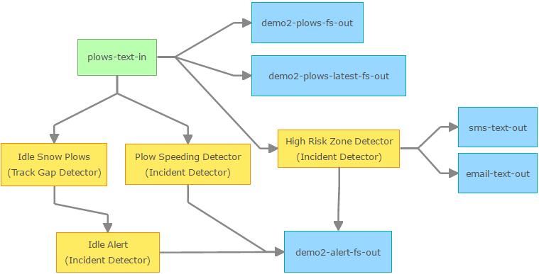


21 Processing Detecting Events of Interest
22 Spatial Operators Used by both filters and processors to determine spatial relationship inside enter intersects touches crosses overlaps outside exit disjoint contains equals within In GeoEvent Server, any geometry can serve as a geofence

23 Spatial Operators - Example Incoming weather hazard intersects a geofence modeled as a point geometry
24 Spatial Operators: Scope Intersects Any geofence Intersects All geofences

25 Spatial Operators - Example Vehicles enter or leave assigned area


26 Spatial Aggregation Hex Bin Data is visualized in high volume
27 4 Integrating Real-Time Data in Web Apps
28 Visualization choosing a service type: stream service, feature service, map service Stream layers in apps subscribe to stream services to immediately visualize observations - Does not require storage, low latency, no playback Map & Features layers in apps periodically poll to visualize most current observations - Backed by an enterprise geodatabase (EGDB) or a spatiotemporal big data store (BDS) - History can be retrieved & queried for playback Send Features to a Stream Service Stream Service subscribe (push) web Add or Update a Feature GeoEvent Server Add a Feature to a BDS Update a Feature in a BDS EGDB ArcGIS Enterprise polling (pull) device GeoAnalytics Server spatiotemporal big data store Map Service Feature Service desktop Stream Layer Map Layer Feature Layer


29 Demonstration Real-Time Data
30 5 Wrap-up
31 Summary Real-Time GIS: GeoEvent Server ArcGIS Enterprise is a full-featured mapping and analytics platform GeoEvent Server brings real-time capabilities to the ArcGIS Enterprise Licensing roles allow ArcGIS Server, a component of the enterprise, to be licensed in different ways - GIS Server /what-is-arcgis-gis-server-.htm - Image Server /what-is-arcgis-image-server-.htm - GeoEvent Server /what-is-arcgis-geoevent-server.htm - GeoAnalytics Server /what-is-arcgis-geoanalytics-server-.htm - Business Analyst Server /what-is-arcgis-business-analyst-server-.htm GeoEvent Server is Real-Time GIS for your ArcGIS Enterprise
32 Summary Real-Time GIS: GeoEvent Server GeoEvent Server: - Simplifies real-time data ingest with configurable out-of-the-box inbound connectors - Enables continuous analytics to be executed on event data as it arrives - Extends options for data storage with an enterprise spatiotemporal no-sql data store - Works with GeoAnalytics Server to make batch analytics on high volume data possible - Provides solutions for high volume data visualization with on-the-fly aggregation - Supports stakeholder notification of patterns of interest as they are discovered in real-time Know what is happening, as it happens, so you can make smart decisions faster

33 Summary Real-Time GIS: GeoEvent Server Step-by-Step Tutorials, free to download - Introduction - Stream services - Spatiotemporal Big Data Store - Notifications Blogs and discussions on the forum - Self-paced training and introductions to GeoEvent Server


34 Please take our Survey Download the Esri Events App for ios or Android
35 Questions / Feedback? Please visit us at the booth Anthony Myers Local Government Solutions Engineer awmyers@esri.com Kevin Armstrong Public Safety Solutions Engineer karmstrong@esri.com

36
GeoEvent Server: An Introduction. Adam Ziegler, Solution Engineer
 GeoEvent Server: An Introduction Adam Ziegler, Solution Engineer Agenda 1 2 3 4 5 What is Real-Time GIS? Working with Real-Time Data Applying Real-Time Analytics Visualizing Real-Time Data Wrap-up 1 What
GeoEvent Server Introduction
 GeoEvent Server Introduction RJ Sunderman Real-Time GIS Product Engineer rsunderman@esri.com Sagar Ayare Real-Time GIS Product Engineer sayare@esri.com Agenda 1 2 3 4 5 What is Real-Time GIS? Working with
GeoEvent Server: Introduction
 GeoEvent Server: Introduction Josh Joyner GeoEvent Server, Product Manager jjoyner@esri.com Sagar Ayare Real-Time GIS Product Engineer sayare@esri.com @thetechiesagar Agenda 1 2 3 4 5 What is Real-Time
Monitoring Your Operations David Jacob
 Monitoring Your Operations David Jacob Jeff Shaner Real-time data Vessels Vehicles Sensors Weather People Challenge of Real-time data How do I visualize real-time data? How can I process and analyze it?
Real-Time GIS: GeoEvent Extension
 Real-Time GIS: GeoEvent Extension Greg Tieman gtieman@esri.com RJ Sunderman rsunderman@esri.com What is Real-Time GIS? GIS Data What has happened, what is happening, what will happen Credit: istockphoto/chris_lemmens
GeoEvent Server: An Introduction. Josh Joyner RJ Sunderman
 : An Introduction Josh Joyner RJ Sunderman Agenda: 1 2 3 4 5 Key Product Capabilities Working with Real-Time Data Demo: Vehicle Location and Alert Monitoring Consuming Real-Time Data Wrap-up Real-Time
ArcGIS GeoEvent Server REALTIME GIS. Jay Fowler Solution Engineer
 ArcGIS GeoEvent Server REALTIME GIS Jay Fowler Solution Engineer GOLD S I L V E R T H A N K Y O U T O O UR SPONSORS Agenda REALTIME GIS Intro Real-Time GIS Overview Act I Hop on the bus Act II Radar Love
ArcGIS GeoEvent Processor for Server. Jay Hagen Esri Solution Engineer
 ArcGIS GeoEvent Processor for Server Jay Hagen Esri Solution Engineer GeoEvent Extension Jay Hagen Esri Solution Engineer GeoEvent Extension Real-Time GIS Overview Working with Real-Time Data Performing
ArcGIS GeoEvent Server Overview. Thomas Paschke
 ArcGIS GeoEvent Server Overview Thomas Paschke Agenda 1 2 3 4 5 6 GeoEvent Development GeoEvent Server Real-Time & Big Data @ 10.5.x Visualization Road Ahead (10.6) R&D Project Trinity & Other 1 GeoEvent
ArcGIS for Intelligence: Discern Activities of Interest Through Advanced Analysis. Natalie Feuerstein Ben Conklin Lyle Wright
 ArcGIS for Intelligence: Discern Activities of Interest Through Advanced Analysis Natalie Feuerstein Ben Conklin Lyle Wright Challenges Demo Movement Pattern Dashboard Key Concepts New Analytic Workflow
ArcGIS GeoEvent Server: A Developer's Guide. Mark Bramer Esri Professional Services Vienna, VA
 ArcGIS GeoEvent Server: A Developer's Guide Mark Bramer Esri Professional Services Vienna, VA Agenda Connectors - Inbound - Outbound GeoEvent SDK Transports and Adapters Processors Maven Scripting upstream
GeoEvent Server: Creating Connectors and Processors Using the GeoEvent SDK
 GeoEvent Server: Creating Connectors and Processors Using the GeoEvent SDK Javier Delgadillo Real-Time GIS Developer, Esri jdelgadillo@esri.com Ming Zhao Real-Time GIS Developer, Esri mzhao@esri.com Agenda
Real-Time Data and the Internet of Things (IoT) Adam Mollenkopf Real-Time & Big Data GIS Capability Lead, Esri
 Adam Mollenkopf Real-Time & Big Data GIS Capability Lead, Esri") Real-Time Data and the Internet of Things (IoT) Adam Mollenkopf Real-Time & Big Data GIS Capability Lead, Esri amollenkopf@esri.com @amollenkopf Real-Time GIS bringing geospatial insights to your Environment
Real-Time Data and the Internet of Things (IoT) Adam Mollenkopf Real-Time & Big Data GIS Capability Lead, Esri amollenkopf@esri.com @amollenkopf Real-Time GIS bringing geospatial insights to your Environment
Building Real Time Web Applications with GeoEvent Processor. Ken Gorton, Esri
 Building Real Time Web Applications with GeoEvent Processor Ken Gorton, Esri Agenda An example of how real-time streaming data could save your life Brief intro to Geoevent Processor Some useful GEP outputs
ArcGIS GeoEvent Extension for Server: Building Real-Time Web Apps
 DevSummit DC February 11, 2015 Washington, DC ArcGIS GeoEvent Extension for Server: Building Real-Time Web Apps Ken Gorton GIS Solutions Engineer Esri kgorton@esri.com Agenda Goal : Provide an overview
ArcGIS GeoEvent Processor for Server. Jayson Hagen & Bryan Franey
 ArcGIS GeoEvent Processor for Server Jayson Hagen & Bryan Franey ArcGIS GeoEvent Processor for Server Agenda Real-time GIS Overview Working with real-time data Performing continuous processing and analysis
ArcGIS GeoEvent Extension for Server: Building Real-Time WebApps. Jon Satchwell Professional Services, Esri Switzerland
 ArcGIS GeoEvent Extension for Server: Building Real-Time WebApps Jon Satchwell j.satchwell@esri.ch Professional Services, Esri Switzerland ArcGIS GeoEvent Extension for Server: Building Real Time Web Applications
Building Real-Time Web Applications Using ArcGIS GeoEvent Processor
 Building Real-Time Web Applications Using ArcGIS GeoEvent Processor Ryan Elliott Software Engineer ArcGIS GeoEvent Processor for Server relliott@esri.com James Cardona Web Developer DC Development Center
Real-Time GIS: Applying Real-Time Analytics
 Real-Time GIS: Applying Real-Time Analytics RJ Sunderman GeoEvent Server Product Engineer, Esri rsunderman@esri.com Ken Gorton Real-time/Big Data Product Engineer, Esri kgorton@esri.com Agenda 1 2 3 4
ArcGIS GeoEvent Server: Leveraging Stream Services. Ken Gorton RJ Sunderman
 ArcGIS GeoEvent Server: Leveraging Stream Services Ken Gorton RJ Sunderman Agenda 1 2 3 4 5 Overview of Stream Services & Stream Layers Publishing Stream Services Visualization of real-time data Sample
ArcGIS GeoEvent Server: Leveraging Stream Services
 ArcGIS GeoEvent Server: Leveraging Stream Services James Cardona Web Developer DC R&D Center Tysons jcardona@esri.com RJ Sunderman GeoEvent Server Real-Time Capabilities rsunderman@esri.com Agenda Overview
Real-Time & Big Data GIS: Leveraging the spatiotemporal big data store
 Real-Time & Big Data GIS: Leveraging the spatiotemporal big data store Suzanne Foss Product Manager, Esri sfoss@esri.com Ricardo Trujillo Real-Time & Big Data GIS Developer, Esri rtrujillo@esri.com @rtrujill007
Real-Time & Big Data GIS: Best Practices. Josh Joyner Adam Mollenkopf
 Real-Time & Big Data GIS: Best Practices Josh Joyner Adam Mollenkopf ArcGIS Enterprise with real-time capabilities Desktop Apps APIs live features stream services live & historic aggregates & features
ArcGIS GeoEvent Server: Making 3D Scenes Come Alive with Real-Time Data
 ArcGIS GeoEvent Server: Making 3D Scenes Come Alive with Real-Time Data Morakot Pilouk, Ph.D. Senior Software Developer, Esri mpilouk@esri.com @mpesri Agenda 1 2 3 4 5 6 3D for ArcGIS Real-Time GIS Static
Real-Time & Big Data GIS: Best Practices. Suzanne Foss Josh Joyner
 Real-Time & Big Data GIS: Best Practices Suzanne Foss Josh Joyner ArcGIS Enterprise With Real-time Capabilities Desktop Apps APIs visualization ingestion dissemination & actuation analytics storage Agenda:
What s New in ArcGIS 10.3 for Server. Tom Shippee Esri Training Services
 What s New in ArcGIS 10.3 for Server Tom Shippee Esri Training Services Today s Agenda What is ArcGIS for Server at 10.3 - ArcGIS Platform story - Expanding ArcGIS for Server paradigm What s new in ArcGIS
Building Great Situational Awareness Apps Using ArcGIS Developer Tools. Kerry Robinson Eric Bader Thomas Solow
 Building Great Situational Awareness Apps Using ArcGIS Developer Tools Kerry Robinson Eric Bader Thomas Solow Agenda Situational Awareness in ArcGIS Developing apps in connected environments - ArcGIS Enterprise
Real-Time GIS Leveraging Stream Services
 Real-Time GIS Leveraging Stream Services Suzanne Foss Product Engineer Real-Time GIS Team sfoss@esri.com Javier Delgadillo Real-Time Engineer Real-Time GIS Team jdelgadillo@esri.com Agenda 1 2 3 4 5 Stream
ArcGIS for Server: What s New. Philip Heede, Jay Theodore
 ArcGIS for Server: What s New Philip Heede, Jay Theodore Agenda GIS server Web GIS: Portal for ArcGIS ArcGIS for Server Extensions - GeoEvent Extension - Production Mapping Primary target for new functionality
Real-Time GIS: Leveraging Stream Services
 Real-Time GIS: Leveraging Stream Services Mark Bramer Senior Technical Analyst Esri Professional Services mbramer@esri.com RJ Sunderman Product Engineer GeoEvent Extension Product Team rsunderman@esri.com
Real-Time GIS: The Internet of Things (IoT)
") Esri Developer Summit March 8 11, 2016 Palm Springs, CA Real-Time GIS: Morakot Pilouk, Ph.D. Senior Software Developer, Esri mpilouk@esri.com @mpesri Ming Zhao Real-Time GIS Developer, Esri mzhao@esri.com
Esri Developer Summit March 8 11, 2016 Palm Springs, CA Real-Time GIS: Morakot Pilouk, Ph.D. Senior Software Developer, Esri mpilouk@esri.com @mpesri Ming Zhao Real-Time GIS Developer, Esri mzhao@esri.com
ArcGIS Enterprise: Architecture & Deployment. Anthony Myers
 ArcGIS Enterprise: Architecture & Deployment Anthony Myers 1 2 3 4 5 Web GIS Overview of ArcGIS Enterprise Federation & Hosted Server Deployment Patterns Implementation 1 Web GIS ArcGIS Enabling GIS for
Connecting Space and Time OSIsoft & Esri
 Connecting Space and Time OSIsoft & Esri Presented by Michelle Kuiee Product Manager Frank Batke Senior Systems Engineer 2 Which of these describe your need? Operating Engineers & Analysts Environmental
Working with Feature Layers. Russell Brennan Gary MacDougall
 Working with Feature Layers Russell Brennan Gary MacDougall Working with Feature Layers Session will focus on feature access and editing Highlight new features added over the last few releases Agenda Introduction
ArcGIS Enterprise: An Introduction. David Thom Solution Engineer State Government
 ArcGIS Enterprise: An Introduction David Thom Solution Engineer State Government What is ArcGIS Enterprise? ArcGIS Enterprise is server software that allows you to use infrastructure you manage to implement
PI Integrator for Esri ArcGIS: A Journey Through Time and Space
 PI Integrator for Esri ArcGIS: A Journey Through Time and Space Presented by Vadim Fedorov, Sr. Systems Engineer Elizabeth Ammarell, Product Manager The Past: Where We Started 2 Two companies, one vision
ArcGIS Enterprise: An Introduction. Philip Heede
 Enterprise: An Introduction Philip Heede Online Enterprise Hosted by Esri (SaaS) - Upgraded automatically (by Esri) - Esri controls SLA Core Web GIS functionality (Apps, visualization, smart mapping, analysis
USERS CONFERENCE Copyright 2016 OSIsoft, LLC
 Bridge IT and OT with a process data warehouse Presented by Matt Ziegler, OSIsoft Complexity Problem Complexity Drives the Need for Integrators Disparate assets or interacting one-by-one Monitoring Real-time
Using Collector for ArcGIS and Operations Dashboard for ArcGIS. Mike Sweeney Esri-Charlotte
 Using Collector for ArcGIS and Operations Dashboard for ArcGIS Mike Sweeney Esri-Charlotte Agenda The ArcGIS Platform Desktop Web Device Portal Cloud Server Online Content and Services On-Premises Available
What is new in ArcGIS 10.2.x for Server
 What is new in ArcGIS 10.2.x for Server Ismael Chivite, Greg Tieman Esri UC 2014 Technical Workshop Map cache status Windows and Linux friendly Simplified architecture 64 bit Performance Improvements Administration
BIG DATA COURSE CONTENT
 BIG DATA COURSE CONTENT [I] Get Started with Big Data Microsoft Professional Orientation: Big Data Duration: 12 hrs Course Content: Introduction Course Introduction Data Fundamentals Introduction to Data
Introduction to Your First ArcGIS Enterprise Deployment. Thomas Edghill & Jonathan Quinn
 Introduction to Your First ArcGIS Enterprise Deployment Thomas Edghill & Jonathan Quinn Overview Web GIS options with Esri Building a Base ArcGIS Enterprise Deployment - Overview of Base ArcGIS Enterprise
microsoft
 70-775.microsoft Number: 70-775 Passing Score: 800 Time Limit: 120 min Exam A QUESTION 1 Note: This question is part of a series of questions that present the same scenario. Each question in the series
Developing Real-Time Web Mapping Applications
 Developing Real-Time Web Mapping Applications Adam Mollenkopf, Solutions Product Manager Morakot Pilouk, Senior Software Consultant Hanoch Kalmanovich, Tracking Development Lead Agenda Real-Time Web Mapping
Dynamic Situational Awareness. Through Developer Applications
 Dynamic Situational Awareness Through Developer Applications Mission Focused Applications Building Apps to support operations Agile Simple High-Performance Defense Developers GIS Simplifies Working With
Data Ingestion at Scale. Jeffrey Sica
 Data Ingestion at Scale Jeffrey Sica ARC-TS @jeefy Overview What is Data Ingestion? Concepts Use Cases GPS collection with mobile devices Collecting WiFi data from WAPs Sensor data from manufacturing machines
Developing in Power BI. with Streaming Datasets and Real-time Dashboards
 Developing in Power BI with Streaming Datasets and Real-time Dashboards Code and Slides for this Session https://github.com/criticalpathtraining/realtimedashboards Critical Path Training https://www.criticalpathtrainig.com
ArcGIS Hub: Open data best practices. Graham Hudgins, esri product engineer
 ArcGIS Hub: Open data best practices Graham Hudgins, esri product engineer Agenda Overview of open data in the ArcGIS Hub Example sites - Hubs Around the World Storymap Making a good site map Preparing
Big Data Technology Ecosystem. Mark Burnette Pentaho Director Sales Engineering, Hitachi Vantara
 Big Data Technology Ecosystem Mark Burnette Pentaho Director Sales Engineering, Hitachi Vantara Agenda End-to-End Data Delivery Platform Ecosystem of Data Technologies Mapping an End-to-End Solution Case
USERS CONFERENCE Copyright 2016 OSIsoft, LLC
 Conference Theme and Keywords 2 PI Integrator for Esri ArcGIS Sparkling Maps are just the beginning Presented by Michelle Kuiee, OSIsoft Two companies One Vision We believe data in the hands of smart people
Permissions Grid. Cross-Organization Notification. Contact Upload. User Management. Role Management. Account Setting MASS NOTIF OPERATOR GROUP MANAGER
 Cross-Organization Notification Send notifications to contacts in any organization Contact Upload Upload and view contacts in any organization User Management Create, edit, delete and enable/disable users
ArcGIS Runtime SDK for WPF
 Esri Developer Summit in Europe November 9 th Rotterdam ArcGIS Runtime SDK for WPF Mike Branscomb Mark Baird Agenda Introduction SDK Building the Map Query Spatial Analysis Editing and Geometry Programming
Stanislav Harvan Internet of Things
 Stanislav Harvan v-sharva@microsoft.com Internet of Things IoT v číslach Gartner: V roku 2020 bude na Internet pripojených viac ako 25mld zariadení: 1,5mld smart TV 2,5mld pc 5mld smart phone 16mld dedicated
Cloud Operations Using Microsoft Azure. Nikhil Shampur
 Cloud Operations Using Microsoft Azure Nikhil Shampur Agenda - Overview - ArcGIS Enterprise on Azure strategy - Deployment Options - What s new - 10.6-10.6.1 - Automation, Upgrades - Tips and Tricks -
Android Team Awareness Kit (ATAK) and ArcGIS
 and ArcGIS") Android Team Awareness Kit (ATAK) and ArcGIS Darron Pustam Product Manager, Esri Craig Cleveland Product Engineer, Esri Verne LaClair Product Manager, PAR Agenda Connecting Intel and Operations in Real
Android Team Awareness Kit (ATAK) and ArcGIS Darron Pustam Product Manager, Esri Craig Cleveland Product Engineer, Esri Verne LaClair Product Manager, PAR Agenda Connecting Intel and Operations in Real
Live aus dem Lab: IoT (Internet of Things) - Anwendungen der SAP
 - Anwendungen der SAP") Live aus dem Lab: IoT (Internet of Things) - Anwendungen der SAP Jochen Rundholz, SAP Solution Experience SAP Summit April 2016 2014 SAP AG or an SAP affiliate company. All rights reserved. 1 Hands on
Live aus dem Lab: IoT (Internet of Things) - Anwendungen der SAP Jochen Rundholz, SAP Solution Experience SAP Summit April 2016 2014 SAP AG or an SAP affiliate company. All rights reserved. 1 Hands on
Advances in GIS help create Smarter Communities
 Advances in GIS help create Smarter Communities POP(ovich) Quiz Who is a Desktop User? Who is an ArcGIS Online User? Who is a ArcGIS Server Admin? Who is a Programmer? Who works with or for a government
ArcGIS Enterprise: Architecting Your Deployment
 ArcGIS Enterprise: Architecting Your Deployment ArcGIS Enterprise ESRI USER CONFERENCE 2017 1 Assumptions and Prerequisites This document assumes you are a system architect or an IT administrator (or work
Using Operations Dashboard for ArcGIS: An Introduction
 FedGIS Conference February 24 25, 2016 Washington, DC Using Operations Dashboard for ArcGIS: An Introduction Ken Gorton Carmella A. Burdi, GISP Solution Engineer Esri National Government Team kgorton@esri.com
Streaming Integration and Intelligence For Automating Time Sensitive Events
 Streaming Integration and Intelligence For Automating Time Sensitive Events Ted Fish Director Sales, Midwest ted@striim.com 312-330-4929 Striim Executive Summary Delivering Data for Time Sensitive Processes
Creating Transparency, Openness and Trust: Modern Approach to Redistricting
 Creating Transparency, Openness and Trust: Modern Approach to Redistricting Richard Leadbeater, Esri Jerry Howe, Utah Legislature Larry Boden, Esri NCSL Legislative Summit Sunday, Aug. 6 11:15 am-12:15
ArcGIS Enterprise: Portal Administration BILL MAJOR CRAIG CLEVELAND
 ArcGIS Enterprise: Portal Administration BILL MAJOR CRAIG CLEVELAND Agenda Welcome & Introduction to ArcGIS Enterprise Portal for ArcGIS - Basic Configuration - Advanced Configuration - Deploying Apps
Administering Your ArcGIS Enterprise Portal Bill Major Craig Cleveland
 Administering Your ArcGIS Enterprise Portal Bill Major Craig Cleveland Agenda Welcome & Introduction to ArcGIS Enterprise Portal for ArcGIS Administration - Basic Configuration - Advanced Configuration
Cisco Tetration Analytics
 Cisco Tetration Analytics Enhanced security and operations with real time analytics Christopher Say (CCIE RS SP) Consulting System Engineer csaychoh@cisco.com Challenges in operating a hybrid data center
Architecting the ArcGIS Platform: Best Practices. Raymond Bunn, GISP, PMP Esri Patterns & Practices Solution Architect
 Architecting the ArcGIS Platform: Best Practices Raymond Bunn, GISP, PMP Esri Patterns & Practices Solution Architect E M E R A L D S A P P H I R E T H A N K Y O U T O O UR SPONSORS Please Take Our Survey
ArcGIS Enterprise: Advanced Topics in Administration. Thomas Edghill & Moginraj Mohandas
 ArcGIS Enterprise: Advanced Topics in Administration Thomas Edghill & Moginraj Mohandas Outline Overview: Base ArcGIS Enterprise Deployment - Key Components - Administrator Endpoints Advanced Workflows:
Announcements. Data Sources a list of data files and their sources, an example of what I am looking for:
 Data Announcements Data Sources a list of data files and their sources, an example of what I am looking for: Source Map of Bangor MEGIS NG911 road file for Bangor MEGIS Tax maps for Bangor City Hall, may
Lesson 5 Nimbits. Chapter-6 L05: "Internet of Things ", Raj Kamal, Publs.: McGraw-Hill Education
 Lesson 5 Nimbits 1 Cloud IoT cloud-based Service Using Server at the Edges A server can be deployed at the edges (device nodes) which communicates the feeds to the cloud service. The server also provisions
Quick Start ArcGIS Enterprise with Automation. Shannon Kalisky Mark Carlson Nikhil Shampur Cherry Lin
 Quick Start ArcGIS Enterprise with Automation Shannon Kalisky Mark Carlson Nikhil Shampur Cherry Lin Software installation is my favorite! I really love how complex and repetitive it can be especially
Intelligent Enterprise meets Science of Where. Anand Raisinghani Head Platform & Data Management SAP India 10 September, 2018
 Intelligent Enterprise meets Science of Where Anand Raisinghani Head Platform & Data Management SAP India 10 September, 2018 Value The Esri & SAP journey Customer Impact Innovation Track Record Customer
Deploying and Using ArcGIS Enterprise in the Cloud. Bill Major
 Deploying and Using ArcGIS Enterprise in the Cloud Bill Major Quick Survey Your role in your organization - Developer? - Cloud Admin? Already a cloud user Running Esri deployment on AWS Running Esri deployment
Integrating DHS Geospatial Tools, Infrastructure Data, and Standardized Symbology
 Integrating DHS Geospatial Tools, Infrastructure Data, and Standardized Symbology September 13-14, 2016 www.napsgfoundation.org @napsgfoundation napsgfoundation.org @napsgfoundation 1 Introduction napsgfoundation.org
Data Architectures in Azure for Analytics & Big Data
 Data Architectures in for Analytics & Big Data October 20, 2018 Melissa Coates Solution Architect, BlueGranite Microsoft Data Platform MVP Blog: www.sqlchick.com Twitter: @sqlchick Data Architecture A
ArcWeb Services (APIs, GIS Content and Functionality)
") ArcWeb Services SOAP API Deep Dive Marwa Mabrouk: Saravanan Rajaram: ArcWeb Development Manager ArcWeb Senior QA Engineer Developer Summit 2007 1 Topics Quick Overview Location services Spatial analysis
ArcWeb Services SOAP API Deep Dive Marwa Mabrouk: Saravanan Rajaram: ArcWeb Development Manager ArcWeb Senior QA Engineer Developer Summit 2007 1 Topics Quick Overview Location services Spatial analysis
Data Store Management Best Practices. Bill Major Laurence Clinton
 Data Store Management Best Practices Bill Major Laurence Clinton Session Agenda 1. Overview 2. Installation and Configuration 3. Backing up the data store 4. Restoring the data store 5. Moving data store
Change Management for the ArcGIS Platform for Local Government. Ayan Mitra Seth Lewis
 Change Management for the ArcGIS Platform for Local Government Ayan Mitra Seth Lewis What is Change Management? Process used to ensure that changes to a product or system are introduced in a controlled
3D MAPPING FORUM. Introduction to Modeling and Simulation in Real-Time 3D ArcGIS. Morakot Pilouk, Ph.D. Senior Software Developer/Consultant
 3D MAPPING FORUM Introduction to Modeling and Simulation in Real-Time 3D ArcGIS Morakot Pilouk, Ph.D. Senior Software Developer/Consultant Source: http://en.memory-alpha.wikia.com/wiki/holodeck Source:
Using ArcGIS for Server. Javier Abadía, Esri España Peter McDaid, Esri UK
 Using ArcGIS for Server Javier Abadía, Esri España Peter McDaid, Esri UK 1. Intro 2. ArcGIS for Server = Geospatial Apps Server 3. Map Services Publishing Flow Apps 4. Spatial Functionality Services Publishing
Web App Builder: Code-free Development. Adam Ziegler, Esri-Northeast, Local Government Team
 Web App Builder: Code-free Development Adam Ziegler, aziegler@esri.com Esri-Northeast, Local Government Team Agenda Product overview Web AppBuilder for ArcGIS tour Adding Custom Widgets Community and Resources
Using Node-RED to build the internet of things
 IBM Bluemix Using Node-RED to build the internet of things Ever had one of those days Where the Application works! And then Can we also get some data from the this whatchamacallit? And send the logs off
Flash Storage Complementing a Data Lake for Real-Time Insight
 Flash Storage Complementing a Data Lake for Real-Time Insight Dr. Sanhita Sarkar Global Director, Analytics Software Development August 7, 2018 Agenda 1 2 3 4 5 Delivering insight along the entire spectrum
Understanding ArcGIS Pipeline Referencing for Vertically Integrated Gas Companies. GeoConX 2017 September 7, 2017
 Understanding ArcGIS Pipeline Referencing for Vertically Integrated Gas Companies GeoConX 2017 September 7, 2017 The Asset Intelligence Imperative GOAL The necessity to learn ever more, in as close to
Verarbeitung von Vektor- und Rasterdaten auf der Hadoop Plattform DOAG Spatial and Geodata Day 2016
 Verarbeitung von Vektor- und Rasterdaten auf der Hadoop Plattform DOAG Spatial and Geodata Day 2016 Hans Viehmann Product Manager EMEA ORACLE Corporation 12. Mai 2016 Safe Harbor Statement The following
Fluentd + MongoDB + Spark = Awesome Sauce
 Fluentd + MongoDB + Spark = Awesome Sauce Nishant Sahay, Sr. Architect, Wipro Limited Bhavani Ananth, Tech Manager, Wipro Limited Your company logo here Wipro Open Source Practice: Vision & Mission Vision
Alexander Klein. #SQLSatDenmark. ETL meets Azure
 Alexander Klein ETL meets Azure BIG Thanks to SQLSat Denmark sponsors Save the date for exiting upcoming events PASS Camp 2017 Main Camp 05.12. 07.12.2017 (04.12. Kick-Off abends) Lufthansa Training &
ArcGIS Issues Addressed List
 ArcGIS 10.4.1 Issues Addressed List ArcGIS for Desktop (Also Contains ArcGIS Engine) Portal for ArcGIS ArcGIS Data Store Home Application ArcGIS for Server Amazon Documentation Feature Services Geocode
ArcGIS GeoEvent Extension for Server: The Internet of Things (IoT)
") ArcGIS GeoEvent Extension for Server: The Internet of Things (IoT) C. Adam Mollenkopf Product Lead ArcGIS GeoEvent Extension for Server amollenkopf@esri.com @amollenkopf Morakot Pilouk, PhD Senior Consultant
ArcGIS GeoEvent Extension for Server: The Internet of Things (IoT) C. Adam Mollenkopf Product Lead ArcGIS GeoEvent Extension for Server amollenkopf@esri.com @amollenkopf Morakot Pilouk, PhD Senior Consultant
Data Acquisition. The reference Big Data stack
 Università degli Studi di Roma Tor Vergata Dipartimento di Ingegneria Civile e Ingegneria Informatica Data Acquisition Corso di Sistemi e Architetture per Big Data A.A. 2017/18 Valeria Cardellini The reference
Cortana Analytics : with Raspberry Pi and Weather Sensor
 Cortana Analytics : with Raspberry Pi and Weather Sensor Leila Etaati (Microsoft MVP, PhD, Consultant, and Data science) #614 SQL Saturday South Island Leila Etaati Leila is Microsoft Data Platform MVP,
Enable IoT Solutions using Azure
 Internet Of Things A WHITE PAPER SERIES Enable IoT Solutions using Azure 1 2 TABLE OF CONTENTS EXECUTIVE SUMMARY INTERNET OF THINGS GATEWAY EVENT INGESTION EVENT PERSISTENCE EVENT ACTIONS 3 SYNTEL S IoT
Hidden Gems in JD Edwards Orchestrator and AIS Server
 Hidden Gems in JD Edwards Orchestrator and AIS Server Darryl Shakespeare Senior Director Product Development Oracle JD Edwards EnterpriseOne November 12-17, 2017 Safe Harbor Statement The following is
Get a Second Opinion: Enterprise GIS Health Checks. David Crosby Esri Southeast Regional Professional Services Charlotte, NC
 Get a Second Opinion: Enterprise GIS Health Checks David Crosby Esri Southeast Regional Professional Services Charlotte, NC E M E R A L D S A P P H I R E T H A N K Y O U T O O UR SPONSORS What is an Enterprise
Microsoft. Exam Questions Perform Data Engineering on Microsoft Azure HDInsight (beta) Version:Demo
 Version:Demo") Microsoft Exam Questions 70-775 Perform Data Engineering on Microsoft Azure HDInsight (beta) Version:Demo NEW QUESTION 1 HOTSPOT You install the Microsoft Hive ODBC Driver on a computer that runs Windows
Microsoft Exam Questions 70-775 Perform Data Engineering on Microsoft Azure HDInsight (beta) Version:Demo NEW QUESTION 1 HOTSPOT You install the Microsoft Hive ODBC Driver on a computer that runs Windows
Increase Value from Big Data with Real-Time Data Integration and Streaming Analytics
 Increase Value from Big Data with Real-Time Data Integration and Streaming Analytics Cy Erbay Senior Director Striim Executive Summary Striim is Uniquely Qualified to Solve the Challenges of Real-Time
Enterprise Data Catalog for Microsoft Azure Tutorial
 Enterprise Data Catalog for Microsoft Azure Tutorial VERSION 10.2 JANUARY 2018 Page 1 of 45 Contents Tutorial Objectives... 4 Enterprise Data Catalog Overview... 5 Overview... 5 Objectives... 5 Enterprise
ArcGIS Enterprise Portal for ArcGIS
 Portal for ArcGIS Elzbieta Covington Outline This presentation is an overview of the components of ArcGIS Enterprise, including Installation Architecture Deployment 1 ArcGIS Online Both systems are complementary
Does Your Data Have Harmony. Dan Stone
 Does Your Data Have Harmony Dan Stone Agenda Introduction Configuration Patterns Implementation Approaches Your Feedback ArcGIS for Local Government Esri solutions for local government customers Series
Real-time Streaming Applications on AWS Patterns and Use Cases
 Real-time Streaming Applications on AWS Patterns and Use Cases Paul Armstrong - Solutions Architect (AWS) Tom Seddon - Data Engineering Tech Lead (Deliveroo) 28 th June 2017 2016, Amazon Web Services,
Cisco Tetration Analytics
 Cisco Tetration Analytics Enhanced security and operations with real time analytics John Joo Tetration Business Unit Cisco Systems Security Challenges in Modern Data Centers Securing applications has become
AT&T Flow Designer. Current Environment
 AT&T Flow Designer A Visual IoT Application Development environment that includes reusable components, drag & drop design capabilities, team collaboration, and cloud deployment that allows M2M/IoT developers