Feature Extraction from Imagery & Lidar. Kurt Schwoppe, Esri Mark Romero, Esri Gregory Bacon, Fairfax County
|
|
|
- Ellen Robinson
- 6 years ago
- Views:
Transcription


1 Feature Extraction from & Lidar Kurt Schwoppe, Esri Mark Romero, Esri Gregory Bacon, Fairfax County


2 Today s Speakers Image Processing Experts and Good Colleagues Kurt Schwoppe Industry Lead Esri Mark Romero Specialist Esri Gregory Bacon GIS Analyst III Fairfax County GISP

3 The Science of Where Integrates Dynamic Data About Everything Built Environment Natural Environment I ot

4 Think Big - National Programs ArcGIS Image Server

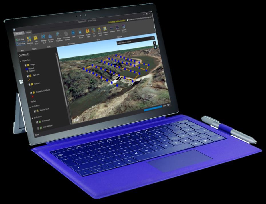


5 Think Small Micro Geographies Drone2Map


6 It Leverages All Types of Remotely Sensed Data Turning imagery into information Drone Mapping Image Analysis Advanced Workstation All Major Sensors Drone2Map Full-Motion Video High-Resolution Satellites Ortho Mapping Small Sats Aerial Photos Dynamic Image Processing Server DTM Generation Seamless Orthophotos Classification Stereo View Change Analysis Image Space and Mensuration... New Image Analyst Extension


 Density")

 Leveraging")

7 is Not an Addition to GIS - It is Part of One Feature Analytics Raster Analytics GeoAnalytics Server Large Observation Collections Image Server Large Collection Space-Time Cube Riparian Areas Power Outages (50+ Million) Density Hot Spots Lidar: Bare Earth Lidar: First Return Faster (10x+) Leveraging Distributed Computing and Parallel Processing... Accessible from ArcGIS Pro and Python API


8 Built Upon an Enterprise Model ArcGIS Pro Image Analyst Extension Web App Builder Services (WABIS) GIS Professionals Server Image Server See the Earth, Find the Patterns, Share with Others


 Data")
9 In Highly Scalable Configurations Specialist ArcGIS Pro Desktop Web Device Portal Clients 2D & 3D ArcGIS Pro Excalibur Web Maps Scenes Enterprise Server(s) Image Server(s) GeoDataBases (Mosaic Dataset) Data Store Configured for Raster


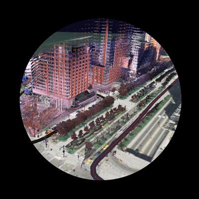
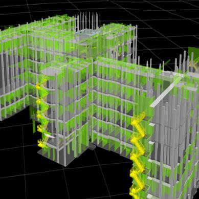
10 The Science of Where is Multidimensional Delineating both 3D Space and Time CAD/BIM Photogrammetry GIS Data Oblique Lidar


11 Image Server Hyper Extends in Pro Infinite Scalability = Raster Analytics Deploy to as many Servers as Needed Full Distributed Processing Elastic Pricing Model*


12 Bundles Support Implementation Patterns Robust Image Processing OrthoMapping and Stereo ArcGIS Pro 2.1 & Image Analyst Extension Image Analytics Ortho Mapping Extracting Features & Change Detection Image Management Make massive collections of imagery accessible Accurate basemaps and Elevation products


13 Image Analyst Extension for Pro 2.1 Improved UI & Display for Mensuration Raster Analytics Stereo Ortho Mapping Workflow & 3D - View imagery undistorted, with vectors transformed to the image - Image coordinate system based measurement - Improved UX for oblique imagery - Sensor model based measurements based on sensor orientation from high resolution satellite imagery and oblique aerial imagery - Workflows and tools for image classification and machine learning - All raster functions that currently require the SA extension, will be available through the Image Analyst extension - Stereo visualization and data capture capabilities, enabling detailed and accurate elevations and height measurements - Production level photogrammetry including triangulation, block bundle adjustments, DEM extraction, and ortho rectification - Extraction of features from point cloud data The Image Analyst Extension extends ArcGIS Pro with advanced tools and user experiences for Image Analysts who perform: Image interpretation and exploitation of imagery Creation of information products from imagery Advanced feature interpretation and measurements from imagery Detailed data capture and measurement on stereo imagery Advanced raster and image analysis workflows for machine learning and feature extraction
 for Dedicated Workflows Image")

14 Image Centric View Improved UI: ELT Like Linked Views Ribbon(s) for Dedicated Workflows Image Coordinate Space: Up is Up! Oblique Viewing - Overlay feature layers - Create and Edit feature layers


15 Precise Measurements Capabilities: Measure distance, area, centroid, azimuth with georeferenced imagery Measure height requires sensor model Measure height from shadow requires sun angle Measure 3D objects Style and annotate measurements Track, store, and manage measurements Report generation for decision makers


16 Raster Analytics Feature Extraction


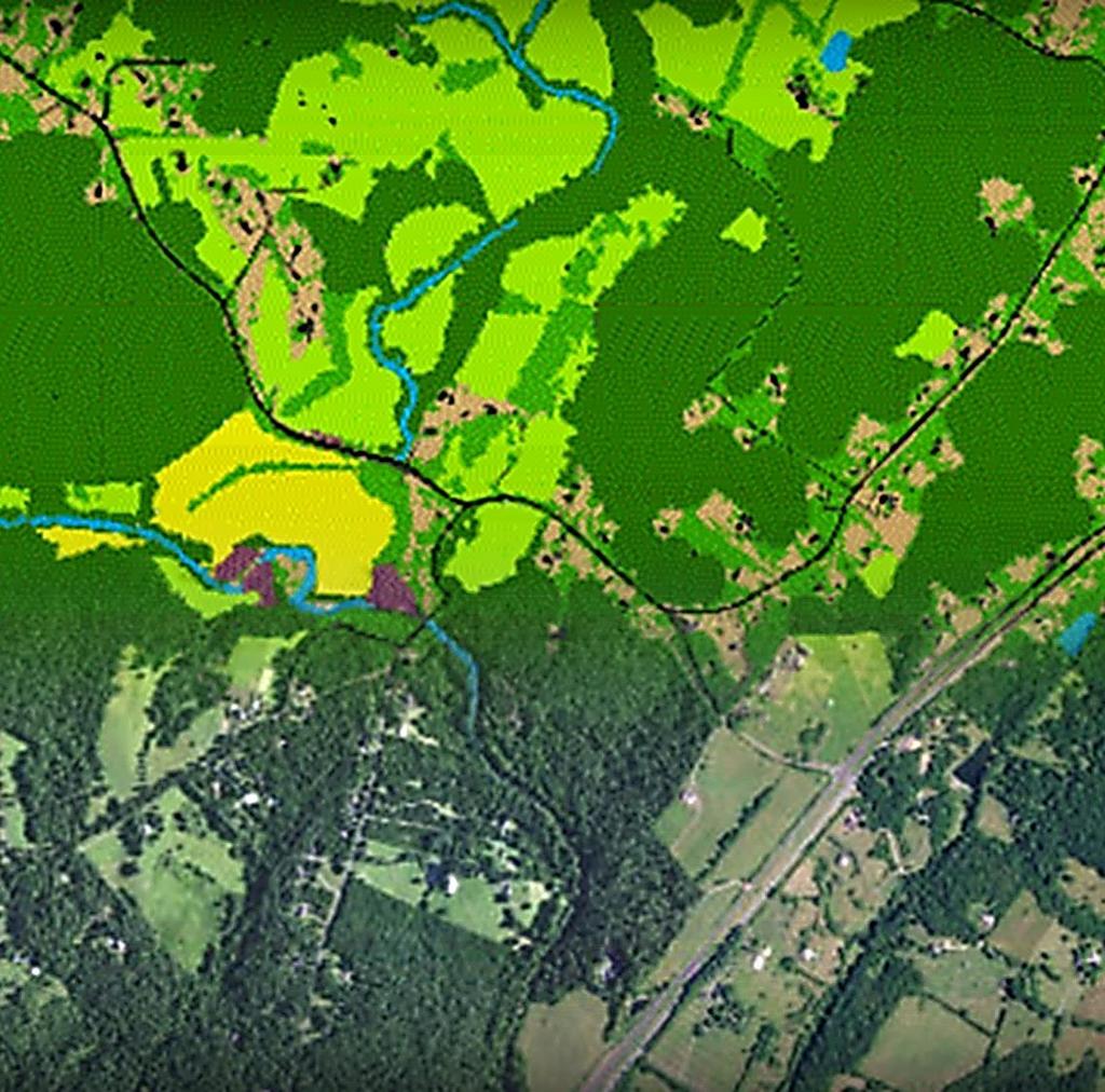
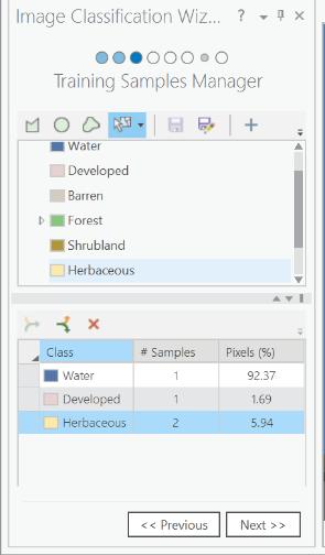
17 Raster Analytics for Land Cover Mapping CBP Land Cover Classification Barren Impervious Roads Impervious Surfaces Low Vegetation Shrubland Structures Tree Canopy Tree Canopy over Impervious Roads Tree Canopy over Impervious Surfaces Tree Canopy over Structures Water Wetlands


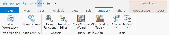
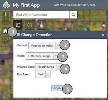
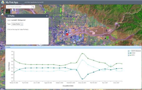
18 Modernizing Feature Extraction Workflow Step 1: Call up an Image Service Step 2: Define your AOI Step 3: Run Classification Wizard Step 4: Vectorize the results Step 5: Publish

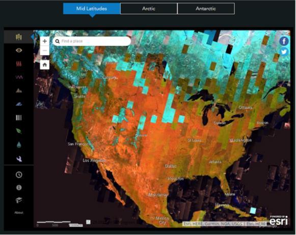
19 Raster Analytics for Change Detection Identifies Changes It shows where we ve been and the direction we are going


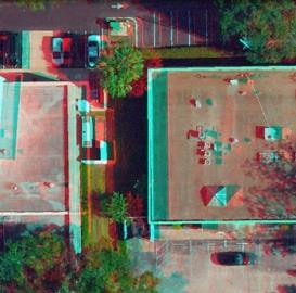
20 Working with Stereo Capabilities: Works with aerial, satellite, and drone imagery Leverages Mosaic Datasets to work with large collections of stereo pairs Consistent Pro editing UX familiar tools, feature template support, etc. New cursor modes, and shapes Shutter glass, and anaglyph stereo viewing Application: Accurate 3D Mapping Improved Image Analysis and Targeting 3D Modeling for Mission Rehearsal


21 Production Ortho Mapping Raw New Web UI Mobile Apps Block Bundle Adjust Ortho ArcGIS DSM Source Mosaic Dataset Refined Bundled Adjustment DTM Derived Mosaic Datasets ArcGIS Pro Point Cloud Image Server Computer Added Design


22 Accurate and Authoritative


23 Ortho Mapping Information Products Base Mapping Site Modeling Inspect & Measure Orthomosaics (.TIFF &.TPK) Digital Surface Model (DSM) Point Cloud (LAS) (imagery derived) 3D Mesh (.OBJ) Annotate Images Volumetric NDVI Contours Scene Layer Package (.SLPK) 3D GeoPDF Inspection Viewer 3D Measure*


24 Working with LIDAR DEM DSM Hillshade Slope Aspect Hydro Solar Features Contours

25 And New Data Models
26 Extend Capabilities to the Web Web App Builder for Services:


27 ArcGIS Pro Feature Extraction Demo Mark Romero

28 Dissemination & Applications Gregory Bacon


29 The Science of Where
What s New in Imagery in ArcGIS. Presented by: Christopher Patterson Date: October 18, 2017
 What s New in Imagery in ArcGIS Presented by: Christopher Patterson Date: October 18, 2017 Imagery in ArcGIS Advancing 2010 Stretch, Extract Bands Clip, Mask Reproject, Orthorectify, Pan Sharpen Vegetation
Drone2Map for ArcGIS: Bring Drone Imagery into ArcGIS
 Drone2Map for ArcGIS: Bring Drone Imagery into ArcGIS Mike Sweeney 1 Drone2Map for ArcGIS Turn Drones into Enterprise Productivity Tools ArcGIS Drone2Map for ArcGIS Create 2D and 3D products from raw drone
Drone2Map for ArcGIS: Bring Drone Imagery into ArcGIS. Will
 Drone2Map for ArcGIS: Bring Drone Imagery into ArcGIS Will Meyers @MeyersMaps A New Window on the World Personal Mapping for Micro-Geographies Accurate High Quality Simple Low-Cost Drone2Map for ArcGIS
What s New in Imagery in ArcGIS. Presented by: Christopher Patterson Date: September 12, 2017
 What s New in Imagery in ArcGIS Presented by: Christopher Patterson Date: September 12, 2017 Agenda Ortho Mapping Elevation extraction Drone2Map Raster Analytics ArcGIS is a Comprehensive Imagery System
Image Management in ArcGIS. Vinay Viswambharan
 Image Management in ArcGIS Vinay Viswambharan Topics covered Primary Imagery Management Information Model - Mosaic Dataset Sharing Imagery using mosaic datasets/image services. Image Services and Cloud
Working with Imagery in ArcGIS. Christopher Patterson October 11, 2018
 Working with Imagery in ArcGIS Christopher Patterson October 11, 2018 Imagery What s New Overview Providing Advanced Processing, Analysis, and Management Desktop and Web Full-Motion Video Mensuration NDVI
IMAGERY FOR ARCGIS. Manage and Understand Your Imagery. Credit: Image courtesy of DigitalGlobe
 IMAGERY FOR ARCGIS Manage and Understand Your Imagery Credit: Image courtesy of DigitalGlobe 2 ARCGIS IS AN IMAGERY PLATFORM Empowering you to make informed decisions from imagery and remotely sensed data
ArcGIS Enterprise: An Introduction. Philip Heede
 Enterprise: An Introduction Philip Heede Online Enterprise Hosted by Esri (SaaS) - Upgraded automatically (by Esri) - Esri controls SLA Core Web GIS functionality (Apps, visualization, smart mapping, analysis
Imagery in ArcGIS: What s New. Peter Becker and Vinay Viswambharan
 Imagery in ArcGIS: What s New Peter Becker and Vinay Viswambharan ArcGIS Provides a Comprehensive Imagery Platform Seamless integration and analysis of imagery with all spatial data A scalable platform
Imagery and Raster Data in ArcGIS. Abhilash and Abhijit
 Imagery and Raster Data in ArcGIS Abhilash and Abhijit Agenda Imagery in ArcGIS Mosaic datasets Raster processing ArcGIS is a Comprehensive Imagery System Integrating All Types, Sources, and Sensor Models
Introduction to the Image Analyst Extension. Mike Muller, Vinay Viswambharan
 Introduction to the Image Analyst Extension Mike Muller, Vinay Viswambharan What is the Image Analyst Extension? The Image Analyst Extension (IA) is an application extension which extends ArcGIS Pro with
The ArcGIS Platform for Managing, Processing, and Sharing UAV Data
 The ArcGIS Platform for Managing, Processing, and Sharing UAV Data Cody Benkelman, Technical Product Manager - Imagery David Gadsden, Nonprofit Program Manager Esri Advancing GIS Strong and Growing..Serving
Drone2Map: an Introduction. October 2017
 Drone2Map: an Introduction October 2017 Drone2Map: An Introduction Topics: - Introduction to Drone Mapping - Coordinate Systems - Overview of Drone2Map - Basic Drone2Map Workflow - 2D Data Processing -
Best Practices for Managing Aerial and UAS Frame Imagery. Cody Benkelman, Jie Zhang
 Best Practices for Managing Aerial and UAS Frame Imagery Cody Benkelman, Jie Zhang Objectives Manage and share collections of imagery from aerial frame cameras - Professional digital cameras - Metric lens,
Managing and Serving Elevation and Lidar Data. Cody Benkelman UC 2018
 Managing and Serving Elevation and Lidar Data Cody Benkelman UC 2018 Outline Usage Modes Data Management - Architecture - Workflow Automation for Repeatability & Scalability A few options Usage Modes of
Managing Imagery And Raster Data Using Mosaic Dataset. Peter Becker & Cody Benkelman
 Managing Imagery And Raster Data Using Mosaic Dataset Peter Becker & Cody Benkelman ArcGIS is a Comprehensive Imagery Platform Imagery is integral to the ArcGIS Platform System of Engagement System of
Lidar and GIS: Applications and Examples. Dan Hedges Clayton Crawford
 Lidar and GIS: Applications and Examples Dan Hedges Clayton Crawford Outline Data structures, tools, and workflows Assessing lidar point coverage and sample density Creating raster DEMs and DSMs Data area
Advances in GIS help create Smarter Communities
 Advances in GIS help create Smarter Communities POP(ovich) Quiz Who is a Desktop User? Who is an ArcGIS Online User? Who is a ArcGIS Server Admin? Who is a Programmer? Who works with or for a government
Raster Analytics in Image Server: An Introduction. Mike Muller
 Raster Analytics in Image Server: An Introduction Mike Muller Introduction and Context The ArcGIS Platform and ArcGIS Image Server enable access to imagery and analysis through a wide range of integrated
Producing Ortho Imagery In ArcGIS. Hong Xu, Mingzhen Chen, Ringu Nalankal
 Producing Ortho Imagery In ArcGIS Hong Xu, Mingzhen Chen, Ringu Nalankal Agenda Ortho imagery in GIS ArcGIS ortho mapping solution Workflows - Satellite imagery - Digital aerial imagery - Scanned imagery
Using Imagery for Intelligence Analysis
 2013 Esri International User Conference July 8 12, 2013 San Diego, California Technical Workshop Using Imagery for Intelligence Analysis Renee Bernstein Natalie Campos Esri UC2013. Technical Workshop.
Managing Imagery and Raster Data using Mosaic Datasets
 Esri European User Conference October 15-17, 2012 Oslo, Norway Hosted by Esri Official Distributor Managing Imagery and Raster Data using Mosaic Datasets Peter Becker ArcGIS is a Comprehensive Imagery
Managing Lidar and Photogrammetric Point Clouds. Lindsay Weitz Cody Benkelman
 and Photogrammetric Point Clouds Lindsay Weitz Cody Benkelman Presentation Context What is lidar, and how does it work? Not this presentation! What can you do with lidar in ArcGIS? What does Esri recommend
Intelligent photogrammetry. Agisoft
 Intelligent photogrammetry Agisoft Agisoft Metashape is a cutting edge software solution, with its engine core driving photogrammetry to its ultimate limits, while the whole system is designed to deliver
Ingesting, Managing, and Using UAV (Drone) Imagery in the ArcGIS Platform
 Imagery in the ArcGIS Platform") Ingesting, Managing, and Using UAV (Drone) Imagery in the ArcGIS Platform Cody A. Benkelman Technical Product Manager Imagery Esri cbenkelman@esri.com Version 2 17 November 2015 This in an Esri draft document
Ingesting, Managing, and Using UAV (Drone) Imagery in the ArcGIS Platform Cody A. Benkelman Technical Product Manager Imagery Esri cbenkelman@esri.com Version 2 17 November 2015 This in an Esri draft document
Automated Feature Extraction from Aerial Imagery for Forestry Projects
 Automated Feature Extraction from Aerial Imagery for Forestry Projects Esri UC 2015 UC706 Tuesday July 21 Bart Matthews - Photogrammetrist US Forest Service Southwestern Region Brad Weigle Sr. Program
Welcome to IMAGIN. June 18, 2018
 Welcome to IMAGIN June 18, 2018 Battle Royale: Pix4D vs Drone2Map A Comparison of Drone Processing Softwares as applied to GIS and a Fly-Through of UAV/GIS workflows 2 Presentation Flight Plan 1. Introductions
ArcGIS Enterprise: An Introduction. David Thom Solution Engineer State Government
 ArcGIS Enterprise: An Introduction David Thom Solution Engineer State Government What is ArcGIS Enterprise? ArcGIS Enterprise is server software that allows you to use infrastructure you manage to implement
An Introduction to Using Lidar with ArcGIS and 3D Analyst
 FedGIS Conference February 24 25, 2016 Washington, DC An Introduction to Using Lidar with ArcGIS and 3D Analyst Jim Michel Outline Lidar Intro Lidar Management Las files Laz, zlas, conversion tools Las
Raster Analysis and Image Processing in ArcGIS Enterprise
 Raster Analysis and Image Processing in ArcGIS Enterprise Vinay Viswambharan, Jie Zhang Overview Patterns of use - Introduction to image processing and analysis in ArcGIS - Client/Server side processing
LORI COLLINS, RESEARCH ASSOCIATE PROFESSOR CONTRIBUTIONS BY: RICHARD MCKENZIE AND GARRETT SPEED, DHHC USF L IBRARIES
 LORI COLLINS, RESEARCH ASSOCIATE PROFESSOR CONTRIBUTIONS BY: RICHARD MCKENZIE AND GARRETT SPEED, DHHC USF L IBRARIES AERIAL AND TERRESTRIAL SURVEY WORKFLOWS Workflow from project planning applications
PhotoScan. Fully automated professional photogrammetric kit
 PhotoScan Fully automated professional photogrammetric kit Agisoft PhotoScan is a stand-alone photogrammetric software solution for automatic generation of dense point clouds, textured polygonal models,
Surveying like never before
 CAD functionalities GCP Mapping and Aerial Image Processing Software for Land Surveying Specialists Surveying like never before www.3dsurvey.si Modri Planet d.o.o., Distributors: info@3dsurvey.si +386
Raster Serving with ArcGIS
 Raster Serving with ArcGIS Agenda Introduction to server technology Workflow considerations ESRI raster serving technology ArcGIS Server Basic (ArcSDE) ArcGIS Server Standard/Advanced Web Services ArcGIS
Image Management and Dissemination. Peter Becker
 Image Management and Dissemination Peter Becker OUTLINE Requirements Intro to Mosaic Datasets Workflows & Demo Dynamic Mosaicking, On-the-fly processing Properties Differentiator Raster Catalog, ISDef,
Image Services for Elevation Data
 Image Services for Elevation Data Peter Becker Need for Elevation Using Image Services for Elevation Data sources Creating Elevation Service Requirement: GIS and Imagery, Integrated and Accessible Field
ArcGIS Enterprise: Sharing Imagery. Zikang Zhou Imagery and Raster team
 ArcGIS Enterprise: Sharing Imagery Zikang Zhou Imagery and Raster team ArcGIS Enterprise: Sharing Imagery PowerPoint slides will be available online. Send me an E-mail if you need it faster: zzhou@esri.com
UAS to GIS Utilizing a low-cost Unmanned Aerial System (UAS) for Coastal Erosion Monitoring
 for Coastal Erosion Monitoring") UAS to GIS Utilizing a low-cost Unmanned Aerial System (UAS) for Coastal Erosion Monitoring A New Window on the World Personal Mapping for Micro-Geographies Accurate High Quality Simple Low-Cost Drone2Map
UAS to GIS Utilizing a low-cost Unmanned Aerial System (UAS) for Coastal Erosion Monitoring A New Window on the World Personal Mapping for Micro-Geographies Accurate High Quality Simple Low-Cost Drone2Map
ArcGIS GeoEvent Server: Making 3D Scenes Come Alive with Real-Time Data
 ArcGIS GeoEvent Server: Making 3D Scenes Come Alive with Real-Time Data Morakot Pilouk, Ph.D. Senior Software Developer, Esri mpilouk@esri.com @mpesri Agenda 1 2 3 4 5 6 3D for ArcGIS Real-Time GIS Static
Creating and Maintaining Your 3D Basemap. Brian Sims Dan Hedges Gert van Maren
 Creating and Maintaining Your 3D Basemap Brian Sims Dan Hedges Gert van Maren Complementary Resource Email (no marketing) A copy of the presentation Links to today s web demos Links to training materials
Workflows for Managing and Serving Elevation (and Lidar) Data. Cody Benkelman
 Data. Cody Benkelman") Workflows for Managing and Serving Elevation (and Lidar) Data Cody Benkelman Outline Usage Modes Data Management - Architecture - Workflow Automation for Repeatability & Scalability A few options re: Cloud,
Workflows for Managing and Serving Elevation (and Lidar) Data Cody Benkelman Outline Usage Modes Data Management - Architecture - Workflow Automation for Repeatability & Scalability A few options re: Cloud,
Designing and Using Basemaps. Jennifer Hughey
 Designing and Using Basemaps Jennifer Hughey Agenda The ArcGIS System Basemaps are a key component of your system Cartographic design considerations Using basemap layers in ArcMap Best practices for designing
ERDAS IMAGINE THE WORLD S MOST WIDELY-USED REMOTE SENSING SOFTWARE PACKAGE
 PRODUCT BROCHURE ERDAS IMAGINE THE WORLD S MOST WIDELY-USED REMOTE SENSING SOFTWARE PACKAGE 1 ERDAS IMAGINE The world s most widely-used remote sensing software package 2 ERDAS IMAGINE The world s most
3D in the ArcGIS Platform. Chris Andrews
 3D in the ArcGIS Platform Chris Andrews Geospatial 3D is already all around us 3D is expanding the GIS community s opportunity to provide value 3D City & Infrastructure Models Generated 3D features Photogrammetrc
ENVI THE PREMIER SOFTWARE FOR EXTRACTING INFORMATION FROM GEOSPATIAL DATA
 ENVI THE PREMIER SOFTWARE FOR EXTRACTING INFORMATION FROM GEOSPATIAL DATA HarrisGeospatial.com BENEFITS Use one solution to work with all your data types Access a complete suite of analysis tools Customize
Integrating Imagery into ArcGIS Runtime Application. Jie Zhang, Zhiguang Han San Jacinto, 5:30 pm 6:30 pm
 Integrating Imagery into ArcGIS Runtime Application Jie Zhang, Zhiguang Han San Jacinto, 5:30 pm 6:30 pm Overviews Imagery is an essential component of ArcGIS - Visualization, Processing and Analysis -
An Introduction to Lidar & Forestry May 2013
 An Introduction to Lidar & Forestry May 2013 Introduction to Lidar & Forestry Lidar technology Derivatives from point clouds Applied to forestry Publish & Share Futures Lidar Light Detection And Ranging
ArcGIS for Server Imagery Update. Cody A. Benkelman Technical Product Manager, Imagery
 ArcGIS for Server Imagery Update Cody A. Benkelman Technical Product Manager, Imagery Outline Mosaic dataset Management and dissemination of imagery - Dynamic image services, Tiled Cache Visualization
Creating raster DEMs and DSMs from large lidar point collections. Summary. Coming up with a plan. Using the Point To Raster geoprocessing tool
 Page 1 of 5 Creating raster DEMs and DSMs from large lidar point collections ArcGIS 10 Summary Raster, or gridded, elevation models are one of the most common GIS data types. They can be used in many ways
Real-Time & Big Data GIS: Leveraging the spatiotemporal big data store
 Real-Time & Big Data GIS: Leveraging the spatiotemporal big data store Suzanne Foss Product Manager, Esri sfoss@esri.com Ricardo Trujillo Real-Time & Big Data GIS Developer, Esri rtrujillo@esri.com @rtrujill007
Exelis Visual Information Solutions Capability Overview Presented to NetHope October 8, Brian Farr Academic & NGO Program Manager
 Exelis Visual Information Solutions Capability Overview Presented to NetHope October 8, 2013 Brian Farr Academic & NGO Program Manager Agenda Overview of ENVI Platform ENVI+IDL ENVI EX ENVI LiDAR Integration
DRONE MAPPING FOR CONSTRUCTION
 DRONE MAPPING FOR CONSTRUCTION POWERFUL SOLUTIONS FOR AS-BUILT SURVEYS AND SITE DOCUMENTATION - AUTOMATED FLEXIBLE PROCESSING - REPEATABLE RELIABLE ACCURACY - APPLICABLE RESULTS WE CAPTURE IMAGES FROM
2010 LiDAR Project. GIS User Group Meeting June 30, 2010
 2010 LiDAR Project GIS User Group Meeting June 30, 2010 LiDAR = Light Detection and Ranging Technology that utilizes lasers to determine the distance to an object or surface Measures the time delay between
Visualizing 2D Data in a 3D World
 Visualizing 2D Data in a 3D World Karl Kliparchuk, M.Sc., GISP, and Brendan Walashek, B.Sc. McElhanney Consulting Services Ltd. Email: kkliparchuk@mcelhanney.com and bwalashek@mcelhanney.com Agenda A Quick
3D Analyst Visualization with ArcGlobe. Brady Hoak, ESRI DC
 3D Analyst Visualization with ArcGlobe Brady Hoak, ESRI DC 3D GIS Viewing geospatial data in 3D leads to new insights 2D 3D Sometimes you need to edit your data in 3D 2D 3D Some problems can only be solved
Trimble Geospatial Division Integrated Solutions for Geomatics professions. Volker Zirn Regional Sales Representative
 Trimble Geospatial Division Integrated Solutions for Geomatics professions Volker Zirn Regional Sales Representative 1 Agenda Trimble GeoSpatial Division Airborne System Solutions Trimble Inpho Software
BRIEF EXAMPLES OF PRACTICAL USES OF LIDAR
 BRIEF EXAMPLES OF PRACTICAL USES OF LIDAR PURDUE ROAD SCHOOL - 3/9/2016 CHRIS MORSE USDA-NRCS, STATE GIS COORDINATOR LIDAR/DEM SOURCE DATES LiDAR and its derivatives (DEMs) have a collection date for data
ENVI 5 & E3De. The Next Generation of Image Analysis
 ENVI 5 & E3De The Next Generation of Image Analysis The information contained in this document pertains to software products and services that are subject to the controls of the Export Administration Regulations
New Features in SOCET SET Stewart Walker, San Diego, USA
 New Features in SOCET SET Stewart Walker, San Diego, USA 2610083107A EXPORT CONTROL DATA. This presentation is approved for export as of 31 August 2007. The actual product and its technical information
From 2D to 3D at Esri
 From 2D to 3D at Esri OGC/EuroSDR workshop on CityGML in National Mapping Paul Hardy phardy@esri.com Business Development Consultant National Mapping & Cadastre Esri 3D GIS Visualize Manage Share Analyze
CREATING CUSTOMIZED SPATIAL MODELS WITH POINT CLOUDS USING SPATIAL MODELER OPERATORS TO PROCESS POINT CLOUDS IN IMAGINE 2014
 CREATING CUSTOMIZED SPATIAL MODELS WITH POINT CLOUDS USING SPATIAL MODELER OPERATORS TO PROCESS POINT CLOUDS IN IMAGINE 2014 White Paper December 22, 2016 Contents 1. Introduction... 3 2. ERDAS IMAGINE
Desktop Workflows: An Introduction to ArcGIS Pro. David Watkins, Mark Smithgall
 Desktop Workflows: An Introduction to ArcGIS Pro David Watkins, Mark Smithgall ArcGIS for Desktop Desktop Web Device ArcMap ArcCatalog ArcScene ArcGlobe ArcGIS Pro Portal Server Online Content and Services
Esri International User Conference. July San Diego Convention Center. Lidar Solutions. Clayton Crawford
 Esri International User Conference July 23 27 San Diego Convention Center Lidar Solutions Clayton Crawford Outline Data structures, tools, and workflows Assessing lidar point coverage and sample density
Serving Imagery with ArcGIS Server 10.1
 Serving Imagery with ArcGIS Server 10.1 Presented by: André Piasta apiasta@esri.ca Esri Canada Users Conference Calgary, AB 28 May 2013 Today s Agenda ArcGIS server and image services Publishing of imagery
Digital Elevation Models (DEM)
") Digital Elevation Models (DEM) Digital representation of the terrain surface also referred to as Digital Terrain Models (DTM) Digital Elevation Models (DEM) How has relief depiction changed with digital
Digital Elevation Models (DEM) Digital representation of the terrain surface also referred to as Digital Terrain Models (DTM) Digital Elevation Models (DEM) How has relief depiction changed with digital
Technical Considerations and Best Practices in Imagery and LiDAR Project Procurement
 Technical Considerations and Best Practices in Imagery and LiDAR Project Procurement Presented to the 2014 WV GIS Conference By Brad Arshat, CP, EIT Date: June 4, 2014 Project Accuracy A critical decision
ERDAS IMAGINE THE WORLD S MOST WIDELY-USED REMOTE SENSING SOFTWARE PACKAGE
 PRODUCT BROCHURE ERDAS IMAGINE THE WORLD S MOST WIDELY-USED REMOTE SENSING SOFTWARE PACKAGE 1 ERDAS IMAGINE The world s most widely-used remote sensing software package 2 ERDAS IMAGINE The Theworld s world
GIS-Generated Street Tree Inventory Pilot Study
 GIS-Generated Street Tree Inventory Pilot Study Prepared for: MSGIC Meeting Prepared by: Beth Schrayshuen, PE Marla Johnson, GISP 21 July 2017 Agenda 2 Purpose of Street Tree Inventory Pilot Study Evaluation
Working with Feature Layers. Russell Brennan Gary MacDougall
 Working with Feature Layers Russell Brennan Gary MacDougall Working with Feature Layers Session will focus on feature access and editing Highlight new features added over the last few releases Agenda Introduction
2/9/2016. Session Agenda: Implementing new Geospatial Technologies for more efficient data capture
 Implementing new Geospatial Technologies for more efficient data capture Jay Haskamp Applied Geospatial Engineer Steve Richter VP Sales Session Agenda: Today s changing technologies and what lies ahead
ArcGIS Enterprise: Architecture & Deployment. Anthony Myers
 ArcGIS Enterprise: Architecture & Deployment Anthony Myers 1 2 3 4 5 Web GIS Overview of ArcGIS Enterprise Federation & Hosted Server Deployment Patterns Implementation 1 Web GIS ArcGIS Enabling GIS for
PhotoScan. Fully automated professional photogrammetric kit
 PhotoScan Fully automated professional photogrammetric kit Agisoft PhotoScan is a stand-alone photogrammetric software solution for automatic generation of dense point clouds, textured polygonal models,
COMPONENTS. The web interface includes user administration tools, which allow companies to efficiently distribute data to internal or external users.
 COMPONENTS LASERDATA LIS is a software suite for LiDAR data (TLS / MLS / ALS) management and analysis. The software is built on top of a GIS and supports both point and raster data. The following software
Best Practices for Managing Processed Ortho Imagery
 Best Practices for Managing Processed Ortho Imagery Cody Benkelman DRAFT slides (June 2017) Characteristics of Processed Ortho Imagery Typically 8 bit (sometimes 16) Typically 3 spectral bands (sometimes
High resolution survey and orthophoto project of the Dosso-Gaya region in the Republic of Niger. by Tim Leary, Woolpert Inc.
 High resolution survey and orthophoto project of the Dosso-Gaya region in the Republic of Niger by Tim Leary, Woolpert Inc. Geospatial Solutions Photogrammetry & Remote Sensing LiDAR Professional Surveying
Surface Analysis with 3D Analyst
 2013 Esri International User Conference July 8 12, 2013 San Diego, California Technical Workshop Surface Analysis with 3D Analyst Khalid H. Duri Esri UC2013. Technical Workshop. Why use 3D GIS? Because
MODULE 1 BASIC LIDAR TECHNIQUES
 MODULE SCENARIO One of the first tasks a geographic information systems (GIS) department using lidar data should perform is to check the quality of the data delivered by the data provider. The department
Creating, balancing and mosaicing Orthophotos
 Creating, balancing and mosaicing Orthophotos Wizards Map production 3D presentations Annotation Orthophoto Surface gridding Contouring Image mosaicing Data compression Geocoding Spatial analysis Raster
Light Detection and Ranging (LiDAR)
") Light Detection and Ranging (LiDAR) http://code.google.com/creative/radiohead/ Types of aerial sensors passive active 1 Active sensors for mapping terrain Radar transmits microwaves in pulses determines
Light Detection and Ranging (LiDAR) http://code.google.com/creative/radiohead/ Types of aerial sensors passive active 1 Active sensors for mapping terrain Radar transmits microwaves in pulses determines
ArcGIS Online. The Road Ahead Geoff Mortson
 ArcGIS Online The Road Ahead Geoff Mortson gmortson@esricanada.com ArcGIS Online Easily create and share maps Delivered as intelligent maps Access on virtually any device anyone, anywhere Compliments and
UAV Flight Operations for Mapping. Precision. Accuracy. Reliability
 UAV Flight Operations for Mapping Precision. Accuracy. Reliability Part One: Why is Mapping different? Part Two: What about accuracy and precision? Part Three: What is the Workflow? Part Four: AGENDA What
Harnessing GIS and Imagery for Power Transmission Inspection. ESRI European Users Conference October 15, 2015
 Harnessing GIS and Imagery for Power Transmission Inspection ESRI European Users Conference October 15, 2015 About Us Airborne/Threod Designer, manufacturer & service provider for multi-rotor & fixed wing
ICIT. Brian Hiller ESRI Account Manger. What s new in ArcGIS 10
 ICIT Brian Hiller ESRI Account Manger What s new in ArcGIS 10 ArcGIS 10 Fast Easy Powerful Everywhere late June 2010 ArcGIS System for Geographic Information Desktop Server Mobile Online A System A Complete
Migrating to ArcGIS Pro. John Sharrard, Esri Solutions Engineer
 Migrating to ArcGIS Pro John Sharrard, Esri Solutions Engineer jsharrard@esri.com ArcGIS Desktop Desktop Web Device ArcMap ArcCatalog ArcScene ArcGlobe ArcGIS Pro Portal Server Online Content and Services
N.J.P.L.S. An Introduction to LiDAR Concepts and Applications
 N.J.P.L.S. An Introduction to LiDAR Concepts and Applications Presentation Outline LIDAR Data Capture Advantages of Lidar Technology Basics Intensity and Multiple Returns Lidar Accuracy Airborne Laser
ArcGIS Enterprise Building Raster Analytics Workflows. Mike Muller, Jie Zhang
 ArcGIS Enterprise Building Raster Analytics Workflows Mike Muller, Jie Zhang Introduction and Context Raster Analytics What is Raster Analytics? The ArcGIS way to create and execute spatial analysis models
UAV Surveying II. Precision. Accuracy. Reliability
 UAV Surveying II Precision. Accuracy. Reliability Part One: Project Lifecycle Deliverables Part Two: Evaluation of UAV Data Accuracy and Examples of Error Part Three: AGENDA Review of Results Examples
Using ArcGIS Server Data to Assist in Planimetric Update Process. Jim Stout - IMAGIS Rick Hammond Woolpert
 Using ArcGIS Server Data to Assist in Planimetric Update Process Jim Stout - IMAGIS Rick Hammond Woolpert Using ArcGIS Server Data to Assist in Planimetric Update Process Jim Stout - IMAGIS Rick Hammond
Developing Imagery Apps Using the ArcGIS API for JavaScript and WebApp Builder. Naila Khan, Chayanika Khatua
 Developing Imagery Apps Using the ArcGIS API for JavaScript and WebApp Builder Naila Khan, Chayanika Khatua What are we talking about today Custom applications Map Viewer Web AppBuilder ArcGIS API for
COMPUTING SOLAR ENERGY POTENTIAL OF URBAN AREAS USING AIRBORNE LIDAR AND ORTHOIMAGERY
 COMPUTING SOLAR ENERGY POTENTIAL OF URBAN AREAS USING AIRBORNE LIDAR AND ORTHOIMAGERY Ryan Hippenstiel The Pennsylvania State University John A. Dutton e-education Institute 2217 Earth & Engineering Sciences
PRODUCT BROCHURE IMAGESTATION HIGH VOLUME PHOTOGRAMMETRY AND PRODUCTION MAPPING
 PRODUCT BROCHURE IMAGESTATION HIGH VOLUME PHOTOGRAMMETRY AND PRODUCTION MAPPING UNPARALLELED PROCESSING, ACCURATE RESULTS FOR CAD AND GIS-BASED WORKFLOWS The ImageStation software suite enables digital
Managing Image Data on the ArcGIS Platform Options and Recommended Approaches
 Managing Image Data on the ArcGIS Platform Options and Recommended Approaches Peter Becker Petroleum requirements for imagery and raster Traditional solutions and issues Overview of ArcGIS imaging capabilities
3D Data Modelling at Esri. Paul Hardy Business Development Consultant Esri Europe
 3D Data Modelling at Esri Paul Hardy phardy@esri.com Business Development Consultant Esri Europe Users of 3D GIS Local government Facilities management Civil engineering 3D GIS Defense / Public Safety
Distributed Image Analysis Using the ArcGIS API for Python
 Distributed Image Analysis Using the ArcGIS API for Python Jie Zhang, Elizabeth Graham The ArcGIS Platform Is a Comprehensive Imagery Platform System of Engagement System of Insight Professional Imagery
UAV s in Surveying: Integration/processes/deliverables A-Z. 3Dsurvey.si
 UAV s in Surveying: Integration/processes/deliverables A-Z Info@eGPS.net TODAY S PROGRAM Introduction to photogrammetry and 3Dsurvey Theoretical facts about the technology and basics of 3dsurvey Introduction
Lecture 4: Digital Elevation Models
 Lecture 4: Digital Elevation Models GEOG413/613 Dr. Anthony Jjumba 1 Digital Terrain Modeling Terms: DEM, DTM, DTEM, DSM, DHM not synonyms. The concepts they illustrate are different Digital Terrain Modeling
JANUARY Migrating standalone ArcGIS Server to ArcGIS Enterprise
 JANUARY 2018 Migrating standalone ArcGIS Server to ArcGIS Enterprise Copyright 2018 Esri All rights reserved. Printed in the United States of America. The information contained in this document is the
Getting Started with Spatial Analyst. Steve Kopp Elizabeth Graham
 Getting Started with Spatial Analyst Steve Kopp Elizabeth Graham Spatial Analyst Overview Over 100 geoprocessing tools plus raster functions Raster and vector analysis Construct workflows with ModelBuilder,
UTILIZACIÓN DE DATOS LIDAR Y SU INTEGRACIÓN CON SISTEMAS DE INFORMACIÓN GEOGRÁFICA
 UTILIZACIÓN DE DATOS LIDAR Y SU INTEGRACIÓN CON SISTEMAS DE INFORMACIÓN GEOGRÁFICA Aurelio Castro Cesar Piovanetti Geographic Mapping Technologies Corp. (GMT) Consultores en GIS info@gmtgis.com Geographic
SOCET GXP. extreme Analysis ELECTRONICS & INTEGRATED SOLUTIONS
 SOCET GXP extreme Analysis ELECTRONICS & INTEGRATED SOLUTIONS extreme Analysis Experience the power of one intuitive software package for advanced image analysis, mapping, geospatial production/photogrammetry,